the clwyd-powys archaeological trust … clwyd-powys archaeological trust annual review 2009/10...
TRANSCRIPT

THE CLWYD-POWYS ARCHAEOLOGICAL TRUST
annual review
2009/10
April 2010

2 CPAT Annual Review 2009/10

3 CPAT Annual Review 2009/10
THE CLWYD-POWYS ARCHAEOLOGICAL TRUST7a Church Street, Welshpool, Powys, SY21 7DLtel. 01938 553670, fax 01938 552179email [email protected], www.cpat.org.uk
Registered Charity No. 508301Limited Company Registered in Wales No. 1212455
© The Clwyd-Powys Archaeological Trust April 2010 File: annual report 09-10.indd
Contents
Preface ...........................................................................................2
Curatorial Work in 2008/09 .............................................................5
Fieldwork and Desk-based Projects in 2009/10 ............................37
Publications and Reports 2009/10 ................................................77
Trustees, Committee Members, Members, Staff, April 2010 .........80

4 CPAT Annual Review 2009/10
Preface
This review has been produced quickly at the end of one financial year and the beginning of the next, and provides a summary of the work undertaken by the Clwyd-Powys Archaeological Trust during the 2009/10 financial year, ending 31 March 2010.
The Trust is grateful for the continuing financial support it receives from both public and private sector bodies, and especially the following during 2009/10 financial year: Aggegates Levy Sustainability Fund; Brecon Beacons National Park; Cadw; Conwy County Borough Council; Countryside Council for Wales; Defence Estates; Flintshire County Council; Forestry Commission; Portable Antiquities Scheme; Powys County Council; Royal Commission on the Ancient and Historical Monuments of Wales; Welsh Assembly Government

5 CPAT Annual Review 2009/10
Curatorial Work in 2009/10
PLANNING SERVICESFunding: Cadw, Brecon Beacons National Park, Conwy County Borough Council, Flintshire County Council, Powys County CouncilThis section, headed by the Development Control Officer (Mark Walters), assisted part time by the Development Control Assistant (Wendy Owen), is part of the Curatorial Section and is line managed by the Head of Curatorial Services (Chris Martin). The main duty of Planning Services is to provide a development control response to local authority consultation on planning applications and to other consultation arising from ‘non-planning’ development.
Funding for CPAT’s Planning Services is provided by grant aid from Cadw. Additional funding has been secured from Flintshire County Council, Conwy County Borough Council, Powys County Council, and the Brecon Beacons National Park and this continues to help maintain present service levels.
Local Authority Liaison The operation of Planning Policy Wales and its ‘archaeologically’ related circulars 60/96 and 61/96 have been monitored by CPAT Curatorial during the year. This guidance continues to be successfully applied in all areas. Contact with planning officers and other planning staffs are maintained on a daily basis during the normal casework consultation process.
Monitoring the effectiveness of Planning Policy Wales etc. 6471 planning applications have been made known to CPAT Curatorial during the financial year. In general there has been an increase in applications submitted to all authorities and the total is close to the number of applications received in 2001/02 (6517). So far the recession does not appear to have had any effect on the level of casework handled by the development control section. In the second half of 2009 it was noticeable that dormant applications with an archaeological commitment via condition were becoming active once more which suggests that the development market is perhaps more confident now than it was in 2008/09. There was also a swing away from minor domestic extensions and alterations in 2008/09 to more new single or multiple dwellings and industrial unit developments in 2009/10. Numbers of planning applications made known to CPAT since 2001/2002
LPA 2002/2003 2003/2004 2004/2005 2005/2006 2006/2007 2007/2008 2008/2009 2009/2010
BBNP 484 502 519 503 496 503 495 505Conwy 774 735 753 711 803 658 543 591Denbighshire 1040 1227 1271 1303 1049 1076 1011 1058Flintshire 1387 1664 1776 1556 1778 1476 1198 1276Powys 2067 2481 2378 2290 2108 1853 1706* 1781*Wrexham 1255 1372 1572 1407 1514 1233 1210 1260TOTAL 7007 7981 8269 7770 7748 7105 6163 6471
* This total includes all applications submitted to Powys CC under the new unified application system from Brecknock, Radnor and Montgomeryshire in 2009/10.

6 CPAT Annual Review 2009/10
Of these 6471 applications, 608 consultations were identified by CPAT as having the potential to impact on the historic environment.
This year CPAT Curatorial has called for 40 field evaluations, desktop assessments or other predetermination actions when considering planning applications. To date, local authorities have implemented 10 of these recommendations. As ever, the ‘shortfall’ is caused by subsequent withdrawal of a small number of applications, but more commonly by delays of at least 6 months on over 50% of the
applications requiring evaluation due to the resale of development plots and subsequent re-applications. As in previous years the majority of these evaluation recommendations have resulted from the potential impacts of relatively small-scale developments in open plots within the historic core of former medieval nucleated settlements. Some larger scale field surveys and assessments have been required, usually in pursuit of Environmental Impact Assessments, or as a result of large-scale green-field development for housing or utilities installations. A total of 36 briefs for archaeological work have been prepared by CPAT
Distribution of all planning applications notified to CPAT during 2009/10.
Distribution of planning applications during 2009/10 which involved some follow-up work by CPAT staff.

7 CPAT Annual Review 2009/10
Curatorial during the year, a number of these being for work recommended within the previous year.
Work undertaken by contractors during the year has been monitored by CPAT Curatorial. These monitoring visits have included single or multiple visits to numerous projects and contractors working in our area over the last year have included AOC Archaeology, APAC Ltd, Cambrian Archaeological Projects, Castlering Archaeology, Clwyd-Powys Archaeological Trust, Earthworks Archaeology, Gwynedd Archaeological Trust, Headland Archaeology, L-P Archaeology, Nick Tavener.
Besides monitoring visits there have been 102 meetings with developers, applicants or planning officers relating to specific casework along with visits to development sites to ascertain the archaeological potential of the site, verify information retained within the HER and to aid the preparation of design briefs. PLANNING CASEWORK Throughout the year the planning services section has been involved in a number of cases that have resulted in positive archaeological recommendations, conservation or mitigation. A small sample of the most interesting of these cases is highlighted below:
Borras Sand and Gravel Quarry Extension, Borras, Wrexham The requirement for assessment of the quarry extensions at the Tarmac owned quarry in Borras was initially identified by CPAT with subsequent curation in the form of a design brief and monitoring falling to the Wrexham County Borough Archaeologist. With the loss of the Wrexham County Archaeologist position in 2007 the curation of this project reverted to CPAT.
Initial investigation work at the quarry site included the recording of the extensive remains of the former WWII RAF airfield structures that would be lost to expansion.
The wider extraction area includes largely low-lying and gently undulating land interspersed with wetland areas, larger ponds and remains of immediately post glacial surface features such a kettle-holes. Walkover survey of this area revealed only post medieval and
later features and the potential for earlier sub-surface archaeology was unknown.
It was decided that a rolling programme of stripping, mapping, sampling and excavation would take place as a condition of consent and in the early summer of 2008 the initial stages of stripping commenced at the northern extreme of the landholding near Caia Farm close to Gresford.
Work continued in 2009 in an area immediately east of the 2008 excavations where topsoil stripping progressed as part of the first phase extension to the quarry. The watching brief commenced in June 2009 and a number of potentially prehistoric features were revealed which were excavated in August and September 2009.
Features identified this year were very similar to those located last year and included pits filled with quantities of charcoal and fore-cracked stone suggesting cooking activity, gullies, post holes, an isolated cremation pit and numerous other pits with no obvious function.
Pottery recovered here suggests occupation of the site in the mid to late Neolithic with a later phase of activity during the Bronze Age. Most of the pottery is in the Peterborough Ware style in use between 3500 and 2500 BC. This has been confirmed by radiocarbon dating of associated charcoal indicating activity in the period 3638 to 3118 BC. The precise nature and function of any settlement here remains in doubt as no clearly defined structures have been recorded but there is clearly a high potential for structural evidence in the immediate vicinity on the higher gravel prominences.
The excavation also revealed the heavily damaged remains of a post medieval dwelling known as White House on the 1839 tithe map. Other than a square stone and brick hearth no structural remains of the 18th-19th century timber frame survived. The structure may have been associated with clay extraction and brick making activity in the late eighteenth century which is known to lie less than a kilometre to the east.
Work will continue at Borras Quarry as further extension takes place and the results of the 2008 and

8 CPAT Annual Review 2009/10
2009 season excavations are currently in the post excavation stage. The excavation has generated a great deal of interest in the media and local community with site tours, articles in local newspapers, TV interviews and radio broadcasts.
Tesco Supermarket Development, Salop Road, Newtown, Powys Excavation of the Roman road on this site followed on from evaluation work completed in 2006 which revealed a well preserved road agger with lateral ditches and a potential for earlier activity in the form of a pit beneath the road construction layers.
Planning permission for a supermarket was subsequently granted early in 2009 with a condition for further investigation and excavation. The excavation by CPAT Contracts and Field Services took place between May and July 2009 The road is a section of the Forden Gaer to Caersws alignment (RR64) which has been known to run along the Severn Valley since at least the early 19th century and can be traced on maps as a continuous field
boundary from at least the late eighteenth century. Recent excavations in Shropshire on a continuation of the same road at Bayston Hill revealed a six metre wide road with flanking ditches and three phases of construction.
Excavations at Newtown also identified three phases of road construction over a total length of some 210 metres. Close dating of the phases was impossible due to the lack of finds which is a common issue with road archaeology of any period. The earliest phase of river cobbles on a clay base appears to have had no associated lateral drainage ditches and was around 4.5 metres in size. There was a patchy stone surface at the side of the road in the west which suggested roadside activity but no structural evidence survived. The second phase of graded river gravels was laid directly on top and contained a number of wheel ruts. An early second century AD coin of Trajan was found in the make-up layers of this phase. The last phase included additional river stone laid over the phase two surface, a south-eastern roadside ditch and an overall final width of around 6 metres.
Aerial phtograph by Nigel Jones of CPAT showing the site of the Trust’s excavations at the Tesco site, Newtown.

9 CPAT Annual Review 2009/10
The last road phase and all other contemporary surfaces and features were subsequently buried by hillwash from the south. Extensive post medieval pitting and modern construction had significantly damaged portions of the road and stratigraphy overall was minimal on this site.
The excavation generated much media and local interest and a site ‘open day’ was well attended with guided tours of the site.
Four Crosses Bypass, Four Crosses, Powys Work commenced on the construction of this bypass in February 2010. CPAT Contracts and Field Services have been contracted by Alun Griffiths Ltd. to complete the extensive fieldwork required by condition. Prior assessment and evaluation in 1998 and 2004 had revealed a high potential for prehistoric archaeology in the northern extreme of the road corridor with post medieval activity at the southern
extreme. The central section of the road corridor was seen to be less archaeologically active, perhaps due to the extensive clays and consequent waterlogged nature of the ground in the past.
The northern and southern extremes have been targeted for intensive monitoring during a controlled strip of the areas down to archaeological levels with subsequent mapping, cleaning and excavation of all identified features. In the north the basal level of the road construction is a metre below the present ground level and slowly rises to the south. In the southern area the basal road level is shallower, but the construction of flood compensation ponds on the northern boundary will require deep excavation through archaeological horizons.
At the time of writing (mid April) the predicted concentration and type of features present here is holding up well. The northern area strip has revealed
Visitors to the Trust’s excavations at the Tesco site, Newtown.

10 CPAT Annual Review 2009/10
extensive pits, post holes, linear ditches, a pit alignment, a compacted stone surface and possible traces of a ring ditch. No excavation of these features has taken place so far as the road contractors require the southern area to be cleared first.
In the south at least three late eighteenth – early nineteenth century clamp type brick kilns have been identified along with two parallel curving ditches of unknown date. It is known that a temporary searchlight installation was situated here in WWII and traces of this may be revealed. The WWI war memorial on the corner of the cross road junction will be removed to another location in the village and has been photographically recorded in its present position.
Excavation and watching brief work will continue at Four Crosses for at least the next two months and possibly longer if more features are revealed in the central road corridor.
Hot Weather Action Plan Pipelines, Powys The rolling watching brief on the Llandinam to Abermule water pipeline was completed in August 2009 by CPAT Contracts and Field Services after lengthy delays due to engineering problems. Overall very few archaeological sites were revealed indicating a low impact by the pipeline construction.
Significant features recorded included a section of the Forden Gaer to Caersws Roman road at Penstrowed. The road was poorly preserved with only the basal river cobble phase present but the overall width was recorded at six metres and there was a roadside ditch on the north-east side. Close to Aberhafesp a clamp type brick kiln was recorded which may have provided the bricks for a nearby derelict barn in the late eighteenth century. A post medieval barn foundation was recorded east of Newtown.
Close to the Caersws Level Crossing road junction a small square enclosure was recorded in the geophysical survey and the outer ditch was explored prior to the pipe trench being excavated. No finds were recovered but the morphology of the enclosure shape and its proximity to the Roman settlement at Caersws suggest a Romano-British date. Much of the enclosure lies buried under the main road and extends into fields to the north.
Tesco Supermarket Development, Welshpool Smithfield, Welshpool, Powys Following earlier evaluation of this site in 2007 a specific area was targeted for excavation which corresponded with deep excavations for the petrol station fuel tanks. This area on the Mill Lane frontage was the scene of a recovery of Roman artefacts by George Boon of the National Museum in Wales in the mid 1950’s when workmen installing a drain revealed complete Roman pottery vessels, a set of iron Fire Dogs and other metal items.
The excavation had to be completed in two phases due to the delayed demolition of a former storage building and the de-activation of services running through the area. Excavation commenced in February and March 2010, with additional work for two weeks in early April that is currently ongoing.
Preliminary results from the excavation indicate an initial prehistoric phase of Neolithic date with transient settlement along the edge of the brook which formerly crossed the site (now culverted). Finds included at least a hundred flint flakes and some tools suggesting flint knapping activity in a closely defined area.
Roman activity consisted of a wide ditch crossing the site diagonally which appeared to act as a primary drainage ditch and which was later cut by other narrower ditch features perhaps representing a field system layout on a different alignment. The wide ditch produced a good quantity of Romano-British pottery. A possible Roman period structure was evidenced in the north by an area of burning and a stone surface but no definite shape or function could be ascertained.
A set of post holes and a surface in the east of the site may be evidence for an early medieval settlement along the Mill Lane frontage. It is unclear whether the compacted stone surface represents a medieval road alignment or a yard/interior surface. An early medieval settlement has long been postulated here as the course of Mill Lane runs between the Domen Gastell motte and bailey castle and Domen Mill to the south and the former Capel Llywelyn on Salop Road to the north. It is possible that this area represented the location of a native settlement before the urban centre shifted to the 13th century planned town location centred on the

11 CPAT Annual Review 2009/10
current cross roads and High Street.
At the time of writing Boon’s trench has just been revealed and a number of pottery and metal artefacts that he discarded have been recovered, but the context of the original deposition event for the Roman artefacts still eludes us and should be revealed when the medieval surface is removed. Excavation and watching brief work will continue here in April 2010.
New Graveyard Extension, Land adj. Llanmerewig Church, Llanmerewig, Powys A pre-determination evaluation was originally recommended here in 1999 due to the location of the plot within a medieval settlement core. The plot is also immediately adjacent to the medieval churchyard boundary which survives as a substantial raised bank and the potential is high for locating the original outer ditch of an early church enclosure. The evaluation recommendation was subsequently overruled by the planning committee and the application received consent with a contracted watching brief condition attached. This condition was totally unworkable as it would have involved an archaeologist being present during the excavation of each new grave! The consent period subsequently lapsed after five years with no development taking place and prior to renewal we were contacted by the Community Council with regard to evaluation prior to submitting a new application.
The evaluation was completed in March 2010 by Cambrian Archaeological Projects and archaeological features were recorded over the whole evaluation area. Two concentric ditches surround the church boundary on the west side and are presumably related either to the earliest church foundation here in the 5th-6th century or belong to a pre-existing, potentially prehistoric, enclosure on the same site. Numerous gullies, pits, post holes and stake holes were also recorded and suggest that permanent settlement in the form of timber framed structures is likely. Unfortunately, none of the features produced reliable dating evidence but this may indicate that the features are quite early, possibly pre-dating the 12th -13th centuries when medieval pottery is more common on settlement sites.
Due to the density and importance of the archaeology
here complete excavation would be the only mitigation possible if the development is given consent once more. We have advised the Community Council to abandon the application due to the high costs of excavation and await their decision.
New Roundabout and Connecting Roads, Ewloe Interchange, Warren Bank, Broughton, Flintshire Following earlier assessment and evaluation of this new roundabout and its connecting road corridors by archaeologists of Gifford Ltd., construction commenced early in 2009 with a condition attached to the permission requiring additional archaeological investigation by strip/map/excavate techniques. The additional investigation work was completed by Earthworks Archaeological Services. The evaluation had identified an area of potential Mesolithic activity due to the presence of a pit with charcoal and a Mesolithic flint blade. There was also some potential for locating the postulated Roman coastal road connection between the forts at Chester and Caernarfon.
The stripped area where the Roman road had been suggested proved to be totally negative with the exception of an undated pit. The area to the south with the prehistoric features did reveal a shallow gully surrounding the Mesolithic pit on two sides and slight evidence for a trampled surface inside this, but there were no associated stake holes. It is possible that this represented a temporary camp structure around a cooking area and as such it is rare evidence of a Mesolithic occupation site in Wales. The Mesolithic site was unfortunately badly damaged by post medieval activity relating to an adjacent dwelling which had been identified on the first edition OS mapping. The foundation of the dwelling, its outer enclosure and an outside privy were all revealed in the excavation and it clearly dated to the late eighteenth or early nineteenth century with brick, glass and pottery scattered over much of the site and in refuse pits.
New Dwelling at Eagles Glen, Four Crosses, Powys Following earlier evaluation in 2009 on the site of a property damaged by fire, the demolition of the old property and construction of a new dwelling commenced in June 2009. The evaluation was designed to test for the presence of Offa’s Dyke at this location where either the basal layers of the rampart
12 CPAT Annual Review 2009/10
or the edge of the western ditch were anticipated. Neither of these features were actually recorded and it was clear that the Offa’s Dyke rampart had been completely truncated. There was no evidence of the ditch either and this must actually lie beneath the present A483. There was archaeology here however and it was all of Roman date! A large pit and shallow gully were recorded with late first and second century Roman pottery.
The condition required the prior investigation of the new dwelling foundations after demolition. The foundation trenches were archaeologically excavated and revealed further Roman pits and an interconnecting system of shallow ditches. The latter features almost certainly relate to some form of field system and similar examples were excavated at the rear of the Vets Surgery in Four Crosses in 2004.
New Residential and Retail Development, South Camp, Sealand Airfield, Sealand Flintshire Following notification from Defence Estates that this former WWI and WWII maintenance and training airfield complex would be demolished to make way for a prestige retail and housing development, a preliminary desktop and field visit assessment of the South Camp was completed by Oxford Archaeology North. The resulting report and the advice of local aviation historians suggested that a number of the buildings on the site were potentially of national importance and this was backed up in 2009 by specialist advice sought from Paul Francis, who
is probably the UK’s leading specialist on airfield structures and has recorded many disused airfields in England for English Heritage. CPAT visited the South and North camps at Sealand in the company of Paul Francis, a number of local aviation historians and staff from the surviving RAF logistics unit at North Camp. A number of clearly unique structures survive here and the complex has excellent group value in connection with the already listed hangars on the business estate immediately north of South Camp. A number of WWI and transition period buildings in particular were unique and nationally important in the UK, not just Wales.
In light of the new information Cadw were invited to review their earlier decision not to protect any of the buildings at Sealand and hopes were high that a representative group of buildings could be saved for future use. Sadly, Cadw did not feel that they could revise their previous advice and no protection was offered.
At the end of March 2010 the South Camp site was sold by Defence Estates to a new developer and we await contact details and information on the nature of any future development. With no protection the options for mitigation are limited. On objection based on the destruction of nationally important buildings would certainly be dismissed due to Cadw’s comments and the likely course of action will be to recommend an English Heritage Level 4 record of all the surviving buildings.
——Mark Walters
13 CPAT Annual Review 2009/10
HERITAGE MANAGEMENTFunding: CadwHeritage Management provides strategic planning advice, elements of Tir Gofal and Glastir support, monument management advice and HER output, information and publicity about project work, advice and support for Cadw-funded pan-Wales schemes and the activities of CPAT and the other Welsh Archaeological Trusts, and support for the Portable Antiquities Scheme in Wales. The Heritage Management Service falls within the Curatorial Section of CPAT and has been staffed during the year by Michelle Bithell (Glastir polygonisation programme), Abi McCullough (Tir Gofal support, Better Woodlands for Wales, Glastir polygonisation programme, outreach work & general heritage management), Chris Martin (Head of Curatorial Services), Jeff Spencer (HER enquiries and management, outreach work & portable antiquities support), Mark Walters (‘non-planning’ development control), Sophie Watson (HER enquiries, Better Woodlands for Wales, Glastir polygonisation programme, outreach work & general heritage management) and Wendy Owen (‘non-planning’ development control & HER enhancement) and by regular volunteer Rod Trevaskus (portable antiquities scheme).
In addition to the continual tasks, such as the support of Cadw’s Scheduling Enhancement Programme, support of Pan-Wales Projects and ongoing liaison with other conservation bodies, the following work has been undertaken during the year.
Scheduled Monument Consents CPAT has been notified of 13 SMC cases during the year, most of which deal with proactive management of monuments rather than ‘development threat’. All bar one of these notifications have been post consent.
Strategic Planning Advice(See also report on Development Plan Support). Wrexham CBC consulted on two draft Local Planning Guidance Notes and six draft Conservation Area Character Assessment and Management Plans.
Interim Development Control Guidance for Windfarms in Powys Although reported on last year and the year before as
nearing publication, the production of this guidance document, by Powys County Council, is still awaited, although it is understood that PCC still intend to follow this item through to completion. It is hoped that this important piece of planning advice may see the light of day during 2010.
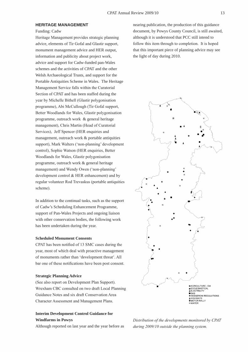
Distribution of the developments monitored by CPAT during 2009/10 outside the planning system.

14 CPAT Annual Review 2009/10
Environment Agency liaison Five consultations have been received in the last year from the Environment Agency or their agents.
The Agency now employs two archaeologists who cover the CPAT area and joint liaison has continued over the last year. A large number of consultations from this source have been related to the improvement of fish stocks in the upper reaches of main rivers and their tributaries by the potential demolition of historic weirs. Consultation on weir demolition or alteration has continued this year although at a slower rate and new areas in Breconshire have been targeted. Our advice has suggested a preference for fish passes rather than the complete demolition of potentially historic weir structures. Where impacts to historic structures are unavoidable appropriate recording has been advised.
In response to severe flooding events in recent years the development control section has also responded to numerous consultations regarding new flood alleviation schemes in town centres. Consultations for flood defence works at Abergele, Denbigh, Ruthin, Caersws and Meifod have all been received this year and in the case of Denbigh, Caersws and Meifod programmes of archaeological assessment and evaluation of potential impact areas are progressing while the Ruthin and Abergele schemes are at a scoping stage.
Water industry CPAT Curatorial has provided detailed comments on 8 schemes under direct consultation with Welsh Water, Severn Trent Water and their various engineering consultants. The majority of these have been small-scale replacement works of existing pipelines or works within existing compounds. Two schemes have attracted a need for prior archaeological assessment or other forms of archaeological mitigation.
A large amount of DC involvement has been generated by the Severn Trent scheme known as the Hot Weather Action Plan. This essentially seeks to boost water supply to key tourist areas in Montgomeryshire where water supplies have been short in hot weather and tanking supplies into these areas is considered non-sustainable. Supply from existing water reservoirs will effectively be doubled by the construction of largely
parallel pipelines in six areas. After lengthy delays and numerous changes to construction contractor and management staff the Llandinam to Abermule pipeline was completed towards the end of 2009. Numerous archaeological sites were discovered and recorded during the intensive watching brief process and these included a new Romano-British enclosure close to Caersws village, a late eighteenth/early nineteenth century brick clamp kiln close to Aberhafesp, a length of the Caersws to Forden Roman road near Penstrowed and a post medieval barn structure close to Newtown.
The Llandrinio pipeline was contaminated in the construction process and had to be re-excavated and buried on a slightly different alignment which necessitated an additional watching brief requirement. The Llansantffraid to Llanymynech pipeline was also completed last year and other than confirming a post medieval trackway, formerly identified form aerial photographs as a possible Roman road, little was recorded on this pipeline route.
Annual liaison with Welsh Water is maintained through attendance at a conservation liaison meeting at the HQ in Nelson, Treharris.
A joint Memorandum of Understanding has been developed relating to consultation procedures between Welsh Water and the Welsh Archaeological Trusts. An Archaeological Management Process Document has also been drawn up in consultation with Laing O’Rourke and a final draft was agreed in March 2009.
Electricity industry 10 schemes have been received for consultation this year. Four of these have attracted recommendations for some form of archaeological assessment prior to development and one required prior scheduled monument consent.
Gas industry Ten consultations have been received over the last year from the gas industry. Nine schemes have been for minor online works to refurbish existing small diameter pipeline routes and no archaeological intervention has been required. One scheme attracted a watching brief recommendation. In all cases now the consultations are received from environmental consultants acting on behalf of the regional National Grid offices.

15 CPAT Annual Review 2009/10
Minerals industry Two consultations relating to minerals planning have been received. Both were for approval of new modern conditions relating to previously consented Interim Development Orders. One of these schemes at Blaen Onnau Quarry near Llangynidr attracted a recommendation for archaeological assessment of a new extraction area within the existing landholding.
Road Schemes The Development Control Section continues to be involved with numerous large trunk road schemes put forward by the Welsh Assembly Government - Transport Division. Major schemes requiring our input in 2009-10 include:
Four Crosses Bypass – Development commenced on this scheme in February 2010 with the setting out of a fenced corridor and removal of hedgerows and trees. Despite all of our consistent and lengthy correspondence over many years on the archaeological commitment required prior to development the construction company were completely oblivious of the scale of archaeological operations and the logistics of operating in conjunction with a team of archaeologists. This necessitated a number of meetings to set up the whole process and secure a field team. Two large areas at the northern and southern extremes of the road corridor had previously been identified for detailed investigation through prior evaluation in 1998 and 2004. These areas are now being systematically stripped under archaeological supervision and all identified archaeology will be excavated.
Cwmbach to Newbridge Bypass – The Orders for the construction of this road scheme were passed in 2010 after a Public Enquiry. The outstanding evaluation of the anomalies, identified by geophysical prospecting in selected areas, was completed in February and March 2010 by Headland Archaeology and the Jacobs consultancy. Despite a large number of evaluation trenches targeted at a wide range of potentially archaeological anomalies none of the trenches revealed any significant archaeology. The quality of interpretation of the geophysical results was clearly poor here as a number of potential field systems, pits, a possible hilltop enclosure and linear features all failed to make an appearance. A standard watching
brief will now be completed during the initial topsoil stripping process.
Builth Bypass – This is scheme is still in the early stages of development and a number of route options are being considered. Environmental Liaison Group meetings are being attended as necessary. Jacobs consultants are once again involved in terms of archaeological consultancy and they have carried out a preliminary archaeological desktop study and walkover. The potential for widening the listed Builth bridge over the River Wye was met with some resistance by the Powys CC Building Conservation Officer.
Newtown Bypass – This scheme is also in its early stages. Initial route options now favour a corridor to the south of the town and industrial estate or online traffic management options. The route to the north of the town was abandoned due to the large number of constraints including scheduled ancient monuments and unscheduled archaeology. Environmental Liaison Meetings are being attended as necessary.
Middletown to Buttington Improvement – Little has moved forward with this scheme for a few years now although it is still being considered a viable option. The scheme may be revived once the new livestock market development is complete at Buttington Cross.
Discussions continue between the Welsh Archaeological Trusts, Cadw and Welsh Assembly Government: Transport Division with regard to the curatorial commitment at various stages of a road development scheme. Currently the Trusts are only funded by Cadw to attend the Environmental Liaison Group meetings and offer initial scoping advice. Subsequent funding for curatorial involvement when the construction commences is supposed to come from the construction company and their clients, but this process is still not working efficiently. Construction companies are also supposed to have included the advice and quotation of an archaeological contractor in the tender process for a road scheme but, as in the case of the Four Crosses Bypass, this is still not happening on a consistent basis.
Ysciog and Christmas Pitch, Erwood Improvement This scheme has been renewed this year after initial

16 CPAT Annual Review 2009/10
scoping and assessment stages in 2006. The scheme requires the straightening of a number of curving bends on the route between Erwood and Llyswen. Much of the work has been minimised in the intervening years and is largely online rather than over new route corridors. The main impact on an undated settlement and metal working site at Alltmawr, which was revealed by evaluation, is no longer threatened. Consultation on this scheme continues.
Windfarms A large number of windfarm applications are currently active in the CPAT area and comments on scoping opinions or advice relating to mitigation recommendations in Environmental Impact Statements have been made for the following in 2009/2010: Llys Dymber Windfarm (Mynydd Hiraethog), Clocaenog Windfarm, Nant Y Moch Area Windfarm, Neuadd Goch Windfarm (Newtown South), Esgair Cwmowen Windfarm, Dyfnant Windfarm, Llaithddu Windfarm, Penrhyddlan North Windfarm Extension, Carno 3 Windfarm Extension.
In conjunction with the windfarms there will be an increasing number of connecting overhead electricity lines and we have been consulted on the Llandinam Windfarm Repowering Line which runs through the Vale of Montgomery registered historic Landscape.
Diocesan Archaeology consultations We received notification of one diocesan faculty application over the last year and this attracted an archaeological watching brief recommendation. Most of these applications now bypass the curatorial section completely and go direct to the diocesan archaeologist who makes recommendations for any archaeological work necessary. The curatorial section will only be involved where the diocesan archaeologist requires a brief, or where a development requires planning permission (eg. with large extensions, or with some curtilage buildings) in addition to a faculty.
Motor Rally consultation This scheme, instigated by Powys County Council, has now been running for five years. This year CPAT has received 27 consultations about planned motor rally events in Powys. The vast majority of these events use existing metalled roads or byways, but permission must be sought from the local authority
to use public rights of way for such purposes. Powys County Council now requires all such applicants to consult CPAT to assess potential impacts on the heritage. Both on and off-road consultations are received from car and motorcycle rally organisers. Rally organizers are supplied with information from the HER and advised on areas to avoid.
During the year three events attracted recommendations for avoidance of identified archaeology on, or close to, the rally route. In each case archaeology was successfully avoided.
Hedgerow Regulations CPAT has received 5 consultations relating to the Hedgerow Regulations. These generally relate to works by local authorities, such as highways improvements, or by utility companies. No archaeological impacts were identified.
Environmental Impact Assessment of Uncultivated Land and Semi-Natural Areas Provisions CPAT has received only 1 consultation relating to the implementation of this EU directive. This case did not need an environmental impact assessment
Forestry Commission liaison General liaison with the Forestry Commission has continued during the year as well as local liaison meetings with regional FC staff. CPAT has attended an annual liaison meeting with the Coed y Gororau district Forestry Commission office in Welshpool, and continues to attend the annual national liaison meeting.
Forestry Design Plans Consultation on 3 design plans has been received. Current HER information was forwarded and standard conservation measures were recommended in line with forestry commission guidance on the preservation of archaeological remains in woodland and management prescriptions arising form the HLF funded Heritage Assets survey. The majority of the plans received are re-submissions of areas previously consulted on in the last round of design plan reviews.
Forestry Felling Licences No felling licence applications have been forwarded to the development control section this year. It is understood that

17 CPAT Annual Review 2009/10
consultation procedures for Felling License applications will be brought into line with those for Better Woodlands for Wales during the coming year.
Welsh Assembly Government Glastir Stakeholders Group CPAT has attended two meetings of this group during the year, representing the four Welsh Archaeological Trusts. Although not expected to start until 2013, the first half of the Glastir scheme (the entry level scheme) is already complete and the second stage (the higher level scheme) is rapidly nearing completion. It is expected that this national liaison work will continue next year.
In addition to this high level liaison a number of Glastir meeting have been held during the year to discuss all aspects of the scheme. For further discussion of the Glastir polygons digitisation programme see the individual project reports.
Built Heritage Forum CPAT has attended both meetings of this Cadw hosted group during the year. It is expected that CPAT will give a presentation about the new on-line HER
software at the next meeting to be held in April 2010.
Bryn Euryn Local Nature Reserve Management Advisory Group The Local Nature Reserve encompasses the multi-period Bryn Euryn Hillfort and Llys Euryn medieval house. In 2009/10 CPAT attended two meetings of the Management Advisory Group chaired by Conwy County Borough Council at their offices in Colwyn Bay. A bid for money to the Tidy Towns fund was successful and upgrading of footpaths and site way marking will now go ahead. A feasibility study for introducing grazing by ponies on the Bryn was produced by CCBC but after discussion, an appeal by the newly formed Bryn Euryn User Association and a vote it was decided not to proceed any further.
Rhydymwyn Valley Site The owners of this site (a Second World War and Cold War era chemical weapons factory now a nature reserve) Defra have chosen not to continue to support the Joint Consultative Board since a change in senior management and the ending of Mr Grant Webberley’s association with the site. Grant, a retired Defra manager chaired the board meetings as a specialist
Forecourt of one of the pyrotechnic magazines at Rhydymwyn Valley Site cleared of 50 to 60 years of undergrowth by Rhydymwyn Valley History Society volunteers.

18 CPAT Annual Review 2009/10
consultant. The Rhydymwyn Valley History Society remains active with a growing membership (it has shot up to 170 from 50 over the course of the year!) keen to clear and interpret parts of the site, publish articles and reports about its history, and who are in the process of building their own website. Articles about aspects of the former chemical weapons factory produced by the group are sent to CPAT for proof reading and several are due for publication in regional journals. During the year CPAT has commented on an application for Scheduled Monument Consent by North East Wales Wildlife (NEWW, who manage the nature reserve on behalf of Defra) for erection of an electric fence and use of one of the factory buildings as an animal shelter. Our advice was to permit the erection of the fence but for NEWW to investigate the possibility of constructing a temporary shelter outside the scheduled area to avoid unnecessary damage to a protected element of the site.
Liverpool Bay Coastal Cell & Shoreline Management Plan CPAT has continued to attend meetings of the steering group for the revision of the Liverpool Bay Shoreline Management Plan.
Offa’s Dyke Path Liaison Committee CPAT has attended one meeting of this management committee hosted by CCW at the Offa’s Dyke Centre in Knighton. Items addressed were mainly path, as opposed to earthwork, related but useful discussions were had on the future work of the Path Management Officer. The Path Management Service has prepared an Interpretation Strategy that identifies the heritage as of key importance to the ongoing management of the path.
Midas HER Compliance Table Review Group CPAT has continued to represent the interests of Welsh HERs (as part of ALGAO) through the UK wide review of the Midas HER Compliance Table as part of the revised MIDAS data standard. This work has been completed during the year and the final publication was launched at the summer meeting of the Historic Environment Forum
Brecon Beacons National Park Advisory Forum CPAT has attended one meeting of the Western Area Advisory Forum and two joint meetings of
both the Western and the Eastern Area Advisory Forums during the year. Attendance has provided a valuable opportunity to raise the profile of the historic environment and the Welsh Archaeological Trusts within the park and park officers and members have welcomed input in matters impacting on the historic environment. Attempts to combat illegal off-roading continue with a promise that the WATs will be consulted if plans to establish designated off-roading areas within the park come to fruition.
Brecon Beacons National Park Sustainable Development Fund Grants Advisory Panel Three meetings of this Panel were attended during the course of the year to advise on applications to the Sustainable Development Fund. The group also enjoyed an ‘away day’ visiting projects that had received funding including Talgarth Mill where it is planned to install hydro-electric generating plant and develop an eco-café.
Twentieth Century Military Structures Liaison Group Two meetings of this group chaired by Cadw were attended at the RCAHMW in Aberystwyth in June
Caring for… booklet produced by Cadw in association with the Twentieth Century Military Structures Liaison Group.

19 CPAT Annual Review 2009/10
and December 2009. Representatives of the Welsh Archaeological Trusts, RCAHMW and Pembrokeshire Coast and Snowdonia National Parks along with individual specialists presented short reports on work on sites and remains of this period in Wales; Cadw contributed an update on their programme of statutory protection. During the course of the year the Caring for Military Sites of the Twentieth Century booklet was published and was enthusiastically received. The December meeting focussed specifically on the sites of crashed aircraft in an attempt to begin to formulate a way to manage these emotive and vulnerable remains. Members of the group joined UPM Tilhill’s Forest Manager John Ferguson on a visit to the site of a crashed Grumman Avenger aircraft near Llangynog to discuss protecting the site when the forestry in which it lies is harvested shortly.
Welsh Industrial Archaeology Panel Jeff Spencer of CPAT chaired the 2009 Welsh Industrial Archaeology Panel meeting at Rhydymwyn, Flintshire in April. After a morning of business and reports from the various parties in attendance the group were shown a film about the site and were conducted on a tour by Colin Barber, Chairman of the
Rhydymwyn Valley History Society.
Powysland Museum, Welshpool In February CPAT was invited by Eva Bredsdorff, Curator of Powysland Museum in Welshpool to assist in the updating and remodeling of the permanent archaeology exhibition. A first meeting was attended where the layout of the exhibition space and presentation of artifacts was discussed and a display case and wall space for use specifically by CPAT was agreed. CPAT’s contribution will extend into the new financial year.
Website Development and Maintenance Work has continued on the CPAT website throughout the year. The number of individual pages continues to grow and as in previous years it is still very gratifying to see that a relevant search in Google still returns CPAT as the first (of 228,000 worldwide) option. Again as in previous years the number of links made to our site by major internet sites such as www.bbc.co.uk continues to rise.
Web statistics for the past year show that there have been 145,508 individual unique pages loaded made by
Wales in the World: distribution of ‘hits’ on the CPAT website in June 2009.

20 CPAT Annual Review 2009/10
83,396 unique visitors of which 11,005 were regularly returning visitors and 72,391 were visiting for the first time. This gives an average of 398 unique pages loaded every day, although the distribution of this activity continues to be uneven across the week. This year visitors have come from 85 different countries with the top ten users being the UK (7871), USA (1194), Canada (250), Ireland (179), Australia (132), Netherlands (103), New Zealand (56), France (49), Germany (42) and India (40) although single visitors continue range from a wide variety of locations such as Brunei Darussalam, Bosnia Herzegovina, Botswana and Brazil. The most popular sections continue to be those on the Historic Churches Survey, Historic Landscapes, the CPAT News pages, and the Offa’s Dyke Initiative, although the prize for the most popular single page (other than the home page) is still, for the third year running, that for the Key Stage 2 educational leaflet Houses and Households: from Neolithic to medieval times (http://www.cpat.org.uk/educate/leaflets/houses/houses.htm). Again as in previous years the majority of visitors come to the site through internet search engines, with Google (and in particular Google Images) still being 25 times more popular than its nearest rival Bing.
Romans in mid Wales Exhibition This exhibition has been out once again, this time to set up camp at the Marches School in Oswestry. The exhibition formed part of the one day seminar Romans and Countrymen: Rome meets the Iron Age in the Northern Marches. This was the Third Annual Seminar organised the Old Oswestry Landscape and Archaeology Project and comprised a series of talks examining the cultural implications the Roman invaders may have had upon the native population of the Northern Marches and North Wales. Over 200 visitors attended the event.
To accompany the virtual reality model produced, originally produced for the 2007 Powysland exhibition, and now mounted on the CPAT website, CPAT has produced a booklet. Copies of this booklet and access to the model can be found at http://www.cpat.org.uk/outreach/exrimw/exrimw.htm.
Historic Environment Network Seminar CPAT has attended two meetings of this group during the year.
Herefordshire Archaeology day out CPAT helped organise a day trip for the members of Herefordshire Archaeology. Some 15 staff were treated to a day in the Walton Basin, looking in particular at the newly excavated Womaston Causewayed Enclosure but also at some of the areas other iconic sites. This was followed by a trip to Beacon Ring to see the Trusts newly acquired hillfort and to discuss plans for its future.
Festival of British Archaeology 2009 What used to be the Council for British Archaeology’s National Archaeology Day, then National Archaeology Week has grown to a 2 week festival celebrating British Archaeology. CPAT were involved in a very successful weekend event held at the Loggerheads Country Park, near Mold in mid-July. The event was organised by Denbighshire County Council and included various activities for people of all ages. The early-medieval re-enactment group Cwmwd Iâl were present, so we tailored our craft activities to the early-medieval period, with ‘Celtic’ shields, brooches and helmets to decorate and wear. These were all extremely popular, with some children making one of everything!
Helmet - check, shield - check, brooch - check!

21 CPAT Annual Review 2009/10
This year we put a lot of thought into ways of gaining feedback from the people visiting our tent, to help us to plan future events. As the event is targeted at families we knew we needed something simple and quick, so we used a target board with sections for each activity. Everyone was given a sticker (colour-coded according to age) and was asked to place the sticker within one of the three bands of the target according to how well they enjoyed the activity. Fortunately we did not have a single sticker in the ‘poor’ band, and vast majority were in the ‘excellent’ band. Though not as detailed or constructive as a questionnaire, for example, the target board allowed immediate appraisal of the activities and is something we will probably use again in the future. Further information about this event can be seen at http://www.cpat.org.uk/outreach/nad/logg09.htm.
Student placements Over the course of the 2 weeks between 6th and 17th July, staff at the Clwyd-Powys Archaeological Trust (CPAT) welcomed 7 young people aged between 15 and 17 from Welshpool High School, Builth High School, Llanidloes High School, Bishop’s Castle Community College and Caereinion High School, Target board in action. © Council for British
Drawing a plan of earthworks at Moat Farm

22 CPAT Annual Review 2009/10
Llanfair Caereinion on work experience placement. The aim was for the students to help CPAT with a range of activities to discover valuable new information about archaeological sites in Powys. The students themselves arranged their work-experience placements with support from their schools and ‘Careers Wales/Gyrfa Cymru’. Our task at CPAT was to inspire them to become the next generation of archaeologists!
Students were initially taken on a tour of some local historic sites, including Offa’s Dyke and Montgomery Castle. After this things really hotted up with buildings survey round Welshpool and both earthwork survey and geophysical survey at Moat Farm, a medieval site just outside the town. Good work was also done at Beacon Ring, the hillfort that has been in CPAT’s ownership since July 2008. An EDM survey of the earthworks at the south entrance was carried out along with a geophysical survey of the same area and a study of the different types of vegetation over the whole site. Once again CPAT is very happy to be joined by Mr John Burman (an expert from North Wales) to carry out the geophysical surveys.
At the end of the two weeks, the students produced their own CPAT web page where they have presented the results of their work. This can be seen at http://www.cpat.org.uk/outreach/nad/workex09.htm.
This year’s event was a great success and having our own hillfort to work on has been of tremendous benefit. A feedback session was held on the final day of the placements with a discussion guided by Cadw’s Generic Learning Outcomes the results of which were very positive and demonstrated the range of benefits of hosting work experience placements.
Top: Surveying the earthworks at Beacon Ring hillfortBottom: Geophysical survey at Beacon Ring with expert Mr John Burman.Right: A smiling team of placement students!
23 CPAT Annual Review 2009/10
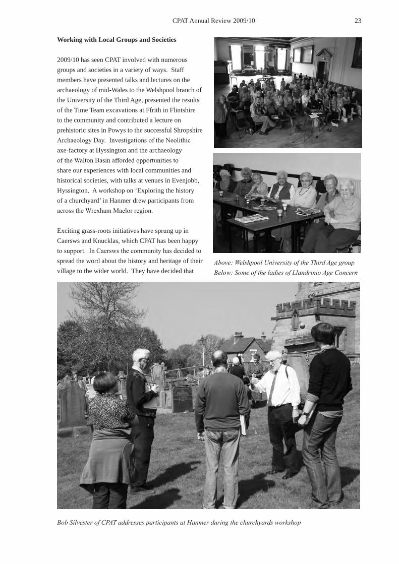
Working with Local Groups and Societies
2009/10 has seen CPAT involved with numerous groups and societies in a variety of ways. Staff members have presented talks and lectures on the archaeology of mid-Wales to the Welshpool branch of the University of the Third Age, presented the results of the Time Team excavations at Ffrith in Flintshire to the community and contributed a lecture on prehistoric sites in Powys to the successful Shropshire Archaeology Day. Investigations of the Neolithic axe-factory at Hyssington and the archaeology of the Walton Basin afforded opportunities to share our experiences with local communities and historical societies, with talks at venues in Evenjobb, Hyssington. A workshop on ‘Exploring the history of a churchyard’ in Hanmer drew participants from across the Wrexham Maelor region.
Exciting grass-roots initiatives have sprung up in Caersws and Knucklas, which CPAT has been happy to support. In Caersws the community has decided to spread the word about the history and heritage of their village to the wider world. They have decided that
Above: Welshpool University of the Third Age groupBelow: Some of the ladies of Llandrinio Age Concern
Bob Silvester of CPAT addresses participants at Hanmer during the churchyards workshop

24 CPAT Annual Review 2009/10
the first step should be the production and erection of 5 information boards presenting information about, amongst other things, the 2 Roman forts and the Roman settlement (vicus) beneath the village. CPAT has contributed specialist advice and information for the editorial group responsible for producing the boards and we hope to continue our involvement over the coming year. CPAT has also contributed to the Knucklas Community Land Project with staff providing background support for fieldwalking and metal detecting on fields below the castle hill and organised and ran a recording day for locals who wanted to learn how to record their parish church and churchyard.
During the course of the year further talks were given to Newtown Civic Society, Builth Wells and District Heritage Society, The Arwystli Society, Welshpool Parkinson’s Disease Society, Tregynon Good Companions’ Club, Coedpoeth History Society, Old Radnor WI and four Age Concern Montgomeryshire groups! Bill Britnell talks to walkers on a joint visit with the
Montgomeryshire Wildlife Trust to Rounton Iron Age hillfort.
A small but happy band beside the canal during ‘Be a Local Tourist Week’ in Welshpool. Two people returned from the USA after enjoying last years event so much!

25 CPAT Annual Review 2009/10
Guided walks and site visits CPAT has led a number of historically and archaeologically themed walks and site visits during the year. One of the most rewarding being a short trip by CPAT staff down the road to Maesydre School in Welshpool where nearly 100 children in the four Year 3/4 classes joined in activity sessions to learn about archaeology and the Romans. CPAT staff organised an open day to view the excavation of the Roman road at the Tesco site in Newtown which despite unseasonal weather for July attracted 150 people and staff once again contributed to Welshpool Town Council’s ‘Be a Local Tourist’ week with a walk along the Montgomeryshire Canal and participation in an ‘Ask the Expert’ session.
CPAT staff supervised the membership of the Llandudno and Colwyn Bay History Society who undertook a small excavation to the south of Ffynnon Elian (Saint Elian’s Well) at Llanelian, Conwy and jointly led a walk up the (very steep!) Roundton Hill with an expert from the Montgomeryshire Wildlife Trust.
The database of heritage societies and similar organisations in the CPAT area has been maintained this year along with an outreach events database of information on walks and talks led by CPAT staff. Articles about CPAT’s various outreach events have been posted on the News page of our website (http://www.cpat.org.uk/news/news.htm).Photos 2900-0001.jpg A small but happy band beside the canal during ‘Be a Local Tourist Week’ in Welshpool. Two people returned from the USA after enjoying last years event so much!2824-0004 or 0007 Bill Britnell talks to walkers on Corndon
Liaison with other groups and professional bodies Throughout the year meetings and events were attended to liaise with archaeological and other bodies including; the Association of Local Government Archaeological Officers Cymru committee, the ALGAO HER committee, the ALGAO Countryside committee, the ALGAO UK national executive, the ALGAO Heritage Protection Review group, the Welsh Archaeological Trusts’ Curators Group, WAT HER Officers Group, WAT Development Control Officers Group, Cadw’s Heritage Management Group,
the Strategic Framework for Historic Environment Records in Wales working group, IFA Wales, the Historic Environment Group, Built Heritage Forum, The Archaeological Forum, Natur, DEFRA, CCW National Trails team, Powys County Council Rights of Way, Northern Marches Leader Plus, Welshpool Town Council, Heather & Hillforts Project, the Powysland Club, the Radnorshire Society, St Asaph Diocesan Advisory Committee, Medieval Settlement Research Group, Cambrian Archaeological Association, Wrexham Heritage Society, Oldford Force Metal Detecting Group, HER Forum, Caer Alyn Project, the Brecknock Society, Clwydian Range LPAG, Heritage Lottery, Association of Diocesan & Cathedral Archaeologists, Wrexham Archaeology Service, Denbighshire Countryside Service, Better Woodlands for Wales steering group, the Open Churches Network, WAG Tir Gofal Stakeholders Group, Hereford Archaeology, Cadw Convergence Funding project, Ffynnon Elian interest group, and the Rhuddlan Local History Society.
IT systems support The Curatorial Section continues to provide hardware and software support across CPAT.
——Chris Martin, Mark Walters. Jeff Spencer Abi McCullough, Sophie Watson
LANDMAP QUALITY ASSURANCE PANEL CPAT Project 1045Funding: Countryside Council for WalesCPAT has continued to input into this CCW convened panel, and has attended 6 monthly panel meetings. This year work has concentrated on the monitoring exercise undertaken in Torfaen. The purpose of this has been to test the procedures for monitoring landscape change being evolved within LANDMAP and to see which of the various remote sensing options provides a good base line from which to work. This has involved the desk-based assessment of a number of remotely derived data sources (satellite imagery, aerial photography, OS mapping, Phase 1 habitat survey) and the field testing of the results obtained. Two presentations have been given to members of Torfaen and neighbouring councils.
——Chris Martin

26 CPAT Annual Review 2009/10
GLASTIR POLYGONIZATION PILOT CPAT PROJECT 1621Funding: CadwCPAT worked in partnership with the Dyfed Archaeological Trust to trial approaches to drawing GIS polygons around sites deemed to be manageable under the Glastir agri-environment scheme. The Glastir scheme is to replace the Tir Gofal scheme in 2013, and although not a whole farm scheme in the manner of Tir Gofal it is hoped that the identification of manageable sites will enable their protection by the entry-level scheme.
——Chris Martin
GLASTIR POLYGONISATION CPAT Project 1630Funding: CadwFollowing on from the pilot exercise CPAT embarked on a programme of polygonization, with the aim of drawing a GIS polygon around every site, or combination of sites, that could be managed by the Glastir agri-environment scheme. Each drawn polygon has been numbered and a range of metadata recorded for it. An accompanying database has been prepared relating the number of Historic Environment Record sites to the drawn polygons. Both the drawn polygons and the database will be submitted to the Welsh Assembly Government’s cartographic section and will be used to identify historic environment features within the Glastir scheme. As yet only the first part of the task, to draw some 7500 polygons, has been achieved, but as the work must be completed by June 2010 it is expected to continue into next year.
——Chris Martin
GLASTIR POLYGONISATION QUALITY ASSURANCE CPAT project 1631Funding: CadwCPAT have been quality assuring the product of the main Glastir polygonization project. This work has entailed the gathering of the drawn data and the accompanying database from the four Welsh Archaeological Trusts, and checking this for structural errors. So far over 12,600 polygons have been checked and submitted to the Welsh Assembly Government.
——Chris Martin
LOCAL DEVELOPMENT PLAN SUPPORT CPAT PROJECT 1581Funding: CadwCPAT has continued to liaise with local planning authorities over the production of the final round of Unitary Development Plans and the phasing in of Local Development Plans, and similar strategic documents throughout the year. The Powys County Council Unitary Development Plan was formally adopted in March 2010. Work is currently under way to consolidate the Deposit Draft Unitary Development Plan with the Modifications of 2007, 2008, 2009 & 2010. The Brecon Beacons National Park approved their UDP in March 2007 for development control purposes and it supersedes the May 1999 Local Plan.
Distribution of polygons drawn for the Glastir agri-environment scheme in the CPAT area during 2009/10.

27 CPAT Annual Review 2009/10
BETTER WOODLANDS FOR WALES Funding: Forestry CommissionLaunched in 2006, Better Woodlands for Wales is the new Forestry Commission Wales (FCW) grant scheme. Replacing Woodland Grant Scheme and the New Native Woodland Planting Scheme, BWW places greater emphasis on good quality woodland management and offers grants specially designed for Welsh woodlands. Grant aid is now based upon an approved long term management plan.
Unlike the previous schemes, the Welsh Archaeological Trusts are now consulted on every
The Conwy County Borough Council Deposit LDP was published for public consultation between 27th April 2009 and 3rd July 2009 and the consultation period on representations closed in December 2009. When adopted this LDP will be current until 2022. The Denbighshire County Council UDP was adopted in July 2002 and is still current. The public consultation period on the deposit LDP has now closed. Adoption of the LDP is anticipated in late 2010. The Wrexham County Borough Council Unitary Development Plan 1996 - 2011 was adopted by Wrexham County Borough Council in February 2005. Consultation on the LDP is due to start. Once adopted it will replace the existing Unitary Development Plan and will cover the period 2006 – 2021. The Flintshire County Council UDP is currently in preparation and this will be the land-use plan for the period 2000 - 2015. Formal adoption of the UDP may be achieved by June 2010 if no further modifications are identified. Consultation was received from Conwy CBC on 110 LDP candidate sites for land allocation in relation to the revised deposit LDP. 9% of these allocations required potential future archaeological intervention should planning applications arise.
——Chris Martin
MONITORING THE HISTORIC ENVIRONMENT CPAT Project 1657Funding: CadwIn previous years this project had been subsumed into the general heritage management work carried out by CPAT - work that comprised the generation of a single database of HER sites for the whole of Wales that could be sampled to provide a monitoring base line. Having collected and sampled this data the project has moved into its second phase that has been to assemble the base-line data sets against which the proposed monitoring work can be carried out. In CPAT this has meant the preparation of 300 dossiers of HER data, site visit forms, aerial and terrestrial photographs and, where appropriate, scheduling and other paperwork. A further 492 dossiers are to be prepared by CPAT in the forthcoming year.
——Chris Martin
Distribution of the Better Woodlands for Wales schemes monitored in the CPAT area during 2009/10.

28 CPAT Annual Review 2009/10
TIR GOFAL Tir Gofal Historic Environment Report 1sFunding: CadwTir Gofal (literally meaning ‘Land Care’) is an agri-environment scheme run by the Welsh Assembly Government, promoting whole farm conservation and management. Since its inception in 1999, Tir Gofal has supported thousands of farmers in protecting both the archaeological heritage and the natural environment in one scheme. There are four main objectives to Tir Gofal: Habitat Conservation (encouraging bio-diversity), Landscape Management (preserving local rural character), Historic and Archaeological Features (protecting archaeological sites, traditional farm buildings, field boundaries, and other historic features), and Access (public access paths across land).
The four Welsh Archaeological Trusts are consulted on every farm that applies to enter the scheme, and subsequently every farm is subjected to a desk-based assessment, or HE1 (Historic Environment Report 1). During this process the Heritage Management team inspect the HER, early OS maps and other sources to provide the WAG with all known information regarding the historic environment of that farm. Roughly 20% of these farms are then visited by the Trusts, to enable more informed decisions on the management of historic features and traditional farm buildings. A second report (HE2, or Historic Environment Report 2) is then produced, and the updated information on the various sites and monuments is then fed back into the HER.
Since the announcement of the Glastir, the new all-Wales agri-environment scheme, Tir Gofal has closed to new applications, so our workload has dropped considerably. During the 2009/10 year, 22 Round 5 HE1 reports have produced and submitted to The National Assembly for Wales. These were produced by Abi McCullough and Sophie Watson.
Five Year Review consultations have continued throughout the year. This review process offers an opportunity to re-examine the historic environment of the farm and introduce new information into the farm’s Tir Gofal Management Plan, whether from additional land, or sites that were not in the HER
application to the scheme, whether for management of existing woodland or areas of new planting. Each case is subjected to a rapid assessment, and if there are any features present, a WHE1 (Woodland Historic Environment Report 1) is produced. During this process the Heritage Management team inspect the HER, early OS maps and other sources to provide the FCW with all known information regarding the historic environment of that area of land. When forestry works are likely to affect historic features within the woodland, the team visits the sites to discuss the proposals with the woodland planners to ensure no unnecessary damage occurs. A WHE2 (Woodland Historic Environment Report 2) report is then compiled.
Up to the end of 2008/09 CPAT received 151 BWW consultations. Of these, 53 WHE1s were compiled, and 1 WHE2 visit (Penpont) was carried out. As usual, the cases consulted on have varied greatly, from small areas of farm woodland, to vast tracts of commercial forestry, to sprawling semi-natural estate woodlands. As the scope of the WHE2 reports has changed somewhat since work on BWW began, the emphasis now is on visiting sites that might be directly affected by certain forestry works. The numbers of visits this year has therefore dropped, accordingly.
The Penpont WHE2 visit was carried out in January, which included an area of Registered Parkland - a predominantly early 19th century park and garden, which was home to the Williams family. There was a large fishpond and dam within the woodland, as well as a number of Listed Buildings that were associated with the parkland, such as Cwm Lodge - an unusual 19th century curved-ended folly building and the Williams Family Vault.
——Sophie Watson

29 CPAT Annual Review 2009/10
TIR GOFAL Tir Gofal Historic Environment Report 1sFunding: CadwTir Gofal (literally meaning ‘Land Care’) is an agri-environment scheme run by the Welsh Assembly Government, promoting whole farm conservation and management. Since its inception in 1999, Tir Gofal has supported thousands of farmers in protecting both the archaeological heritage and the natural environment in one scheme. There are four main objectives to Tir Gofal: Habitat Conservation (encouraging bio-diversity), Landscape Management (preserving local rural character), Historic and Archaeological Features (protecting archaeological sites, traditional farm buildings, field boundaries, and other historic features), and Access (public access paths across land).
The four Welsh Archaeological Trusts are consulted on every farm that applies to enter the scheme, and subsequently every farm is subjected to a desk-based assessment, or HE1 (Historic Environment Report 1). During this process the Heritage Management team inspect the HER, early OS maps and other sources to provide the WAG with all known information regarding the historic environment of that farm. Roughly 20% of these farms are then visited by the Trusts, to enable more informed decisions on the management of historic features and traditional farm buildings. A second report (HE2, or Historic Environment Report 2) is then produced, and the updated information on the various sites and monuments is then fed back into the HER.
Since the announcement of the Glastir, the new all-Wales agri-environment scheme, Tir Gofal has closed to new applications, so our workload has dropped considerably. During the 2009/10 year, 22 Round 5 HE1 reports have produced and submitted to The National Assembly for Wales. These were produced by Abi McCullough and Sophie Watson.
Five Year Review consultations have continued throughout the year. This review process offers an opportunity to re-examine the historic environment of the farm and introduce new information into the farm’s Tir Gofal Management Plan, whether from additional land, or sites that were not in the HER
at the time of the original consultation. Of the 38 consultations processed during the year, 12 required new HE1s.
——Abi McCullough
Tir Gofal Historic Environment Report 2Funding: Welsh Assembly Government Due to the termination of the Tir Gofal scheme, during the 2009/10 year, only 3 heritage management field surveys (HE2s) were carried out. One of these surveys was of a large tract of the Clwydian Hills in Denbighshire. Dominated by several impressive Iron Age hillforts, there are many ‘lesser’ historic features, particularly on the lower slopes that in the past have largely been overlooked. The HE2 survey was a good opportunity to redress the balance, with several field banks, mine shafts and other structures being discovered.
The Special Project reported on in last year’s Annual Report finally took place in February 2010, almost 2 years since CPAT first visited the site. This rather fine double lime kiln had been getting increasingly
obscured and damaged by vegetation, so a project was designed by the Welsh Assembly’s Tir Gofal Project Officer to carefully remove trees and scrub from the top of the structure, and also from the front and sides. CPAT monitored the felling from the top of the kiln, as some of the trees were growing out of the edges of the charging holes. Though we have not visited the site since it was totally cleared, the improvement by the end of the first day was marked.
——Abi McCullough
Above: Top of the kiln before felling.Below: Front of kiln after felling on top.
Distribution of all the Tir Gofal farm applications in the Clwyd-Powys area between 1999-2009

30 CPAT Annual Review 2009/10
PORTABLE ANTIQUITIES SCHEME Funding: Portable Antiquities Scheme via NMW Over the past year 2009/10, we have worked hard to maintain and improve on our data recording for the Portable Antiquities Scheme (PAS). As a result of improved workflow and object collection, we have seen the previous year’s number of items recorded exceeded yet again, by over 60% bringing the total this year to 260 records. Our volunteer staff member, Rod Trevaskus, who has further streamlined his workflow situation and data collation, has achieved this improvement. That level of recording however comes with its own penalties – the time and effort now put in by Rod has increased with much of the work being carried out at home using his resources. In recognition of that work, CPAT has now established a system to remunerate Rod for materials expended.
One area of further improvement over the year has been due to working more closely with several of our independent detector users and singing the virtues of PAS. This has resulted in these ‘independents’
introducing us to their friends/colleagues who also detect, the outcome of which has been the introduction of another three independents to the PAS and our recording service here at CPAT.
We have continued to liaise with North East Wales Community Archaeologist Sarah Pevely who is based at Rhyl Museum and continue to work closely with the Wrexham Heritage Society. Working with them has now brought us closer to more of their members who are happy to place their trust in the systems we have established for the recording and return of their finds. That has also been true of our independents, as with many detectorists, they were initially uncertain of the consequences of reporting their finds. Having established a very clear statement of intent to turn around and return their coveted finds within one month, we now enjoy a steady flow of material/objects. We have also worked to assist in their recognition of the flint and pottery that they may come across whilst detecting. That in-turn has brought some significant finds to add to our recording of the past in
The five Bronze Age palstaves from Nantmel, Powys. Photo: Rod Trevaskus CPAT

31 CPAT Annual Review 2009/10
the Clwyd-Powys region and beyond.
In recognition of the close working relationship we now have with Wrexham Heritage Society and to encourage their membership we have introduced a Find of the Quarter certificate for the member who in our opinion has reported the rarest or most interesting find during the previous quarter. Allied to this we have established a link to their website and have built a dedicated page about the club and their star finds on the CPAT website, which is updated quarterly.
Working with the Oldford Force Team of Welshpool has been more challenging with fewer finds coming in from that source recently, though we intend to redouble our efforts on this front. We still await the Treasure hearing for a medieval silver annular brooch found by a club member, submitted in 2008. The delay in processing it is a cause for concern, possibly leading to the disaffection of some finders. We do our utmost to keep them on side but when these matters drift outside of the guided timelines, it is difficult to keep their attention and good humour.
One particular success with a new member has been the discovery of a significant assemblage of Bronze Age palstaves from Nantmel, Powys. The finder brought in a first palstave and followed it up with a further four over a period of several weeks. Given the significance of the find, they have been sent to the National Museum Wales in Cardiff, for processing through the Treasure scheme.
Following our care and service to the local metal detecting community, the next item on our priority list is the increase of the recording of finds from Wales. Over the past year, the split has been very nearly 60%/40% with the greater number now coming from Wales. However, as with most FLO regions, our finders drift over the borders! Our encouragement of the Wrexham club to shift the focus of their detecting areas into Wales has met with some success.
Toward the end of the financial year, we have been made aware of a new metal detecting club being formed in Brecon. We have established contact via Nigel Blackamore of Brecknock Museum and Mark Lodwick of the National Museum and are in the process of arranging meetings and briefings to their
Above: Jeff Spencer hands the first Find of the Quarter certificate to Julian Owen of the Wrexham Heritage Society.Below: A contemporary forgery of a Charles I penny found near Welshpool. Photo: Rod Trevaskus CPAT
members. It is hoped that this new relationship will further our data recording for Powys finds as it is understood that their interest lies within their local environment.
The addition of new clubs brings with it greater pressure on our annually budgeted funds for the PAS work we undertake at CPAT. Most of the work is now born by our volunteer Rod Trevaskus and whilst we are able to compensate him for the costs of materials used we are calling on him to do more and more. To his credit and the benefit of the PAS, he has agreed to try to increase his efforts. Much of that will depend on the success of the new PAS database and its ability to speed up the recording process. Rod has said that the first impressions are very encouraging! Notwithstanding the efforts put in by Rod, we are still forecasting a shortfall in funding for the coming year.
——Jeff Spencer

32 CPAT Annual Review 2009/10
REGIONAL HISTORIC ENVIRONMENT RECORDFunding: Royal Commission on the Ancient and Historical Monuments, Cadw, CPAT It has been a busy year working with the Historic Environment Record. A review of the HER Benchmark performance measure documents was carried out and where necessary they have been updated in preparation for validation by an independent consultant (see HER Benchmarking below). A new Forward Plan (Benchmark 4.4) for the coming year was drafted and processing of the HER backlog has continued when possible, guided by the HER Audit (Benchmark 3.6). Development of the online HER system WalesHER and Archwilio, the version tailored for public access has also continued apace. The Historic Environment Record lies within the Curatorial Section of CPAT and is line managed by the Head of Curatorial Services.
Staffing and structure Funding for this service is provided by grant aid from the Royal Commission on the Ancient and Historical Monuments of Wales and Cadw with additional funding from other sources, including significant help in kind from Local Authorities under partnership arrangements. Jeff Spencer remains in post as Historic Environment Record Officer and Sophie Watson, Heritage Management Archaeologist continues to assist with HER work, including the management and answering of HER enquiries. In May 2009 additional input on HER backlog processing tasks came from Italian archaeologist Paolo Scozzari who came to us on placement via European Training Services Ltd of Lichfield and since February 2010 a local volunteer, Natasha Arthurs has picked up his work, joining us for half a day per week.
HER Benchmarking The HER Strategic Frameworks Group felt that validation of HER Benchmark performance measure documents by an external assessor should be delayed until Cadw’s Chief Inspector Gwilym Hughes had completed his ‘Guidelines for HER in Wales’ document. However, as the document was nearing completion, it was felt best to proceed with the validation before the end of the financial year. A project brief for the validation project was prepared by RCAHMW and Cadw and put out to tender, Rachel Edwards of Arboretum Archaeological Consultancy, Worcester being commissioned to validate the completed Benchmark documentation of the four Welsh Archaeological Trusts.
The project comprised five stages: Gathering together of Benchmark documentation from all •
HER staff: Jeff Spencer, Sophie Watson and temporary Italian placement Paolo Scozzari

33 CPAT Annual Review 2009/10
four of the Welsh HERs for initial review.A meeting to be attended by representatives of all • four Welsh Archaeological Trusts and the Royal Commission.A detailed review and analysis of the Benchmark • documentation.Contacting of HERs by telephone and email to • discuss the findings of the validation and to seek clarification of any issues.Production of a report summarising progress by • each of the four HERs towards the Benchmarks, highlighting areas where the Benchmark has not been achieved, and making recommendations for further work if necessary.
The final report from Rachel Edwards is awaited but initial feedback suggested there were no areas of significant concern, although to quote Rachel: ‘I appreciate that the issue of staffing and funding is significant for all four HERs. Whilst the minimum interpretation of the benchmark is probably met in all cases, it is not clear that the staffing provision is fully “commensurate with the level of services provided” ‘.
Service Provision to Local AuthoritiesThe CPAT HER is formally recognised by all 5 of its local authorities, and the National Park, as the County Sites and Monuments Record and agreements have been signed with all parties relating to SMR service provision and the reciprocal exchange of data. Data (at various levels) has been exchanged with Conwy County Borough Council, Denbighshire County Council, Wrexham County Borough Council and Powys County Council (and Brecon Beacons National Park), and Flintshire County Council.
During the year CPAT held two training seminars at the Brecon Beacons National Park for park officers and development consultants outlining the potential changes in heritage legislation and looking at how CPAT staff and the new HER software might address some of the issues raised and deliver improved services.
WalesHER software development The new HER software is now in use for intra-trust querying, day-to-day editing and data entry. During the year use expanded to CPAT’s Contracts and Field Services section for Cadw-funded thematic projects.
This new web-based system, a MySQL database mounted on a commercial web server and delivering various PHP and Java scripts via any internet enabled pc using standard web browsers, offers most of the features available from a desktop database application but also includes a fully featured web GIS system. Revised point and polygon data from Cadw for Scheduled Ancient Monuments, Historic Landscape Character areas, Registered Parks and Gardens and Listed Buildings has been incorporated into it. Elements of the previous HER systems are still in use, particularly in handling existing GIS data in MapInfo. The balance of use between the new and old software will continue to alter over the coming year.
A public access front end for the four Welsh HERs, christened Archwilio (Welsh for to search or examine) is the major new feature completed this year. A working application is in place and is awaiting an official launch. As part of the Wales HER Initiative, work is also under way on a reporting function to allow extraction of data for more complex third party enquiries and a support and development contract with software consultant Steve Smith, who continues to guide development of the WalesHER software.
Front page of the new Welsh HER web-based enquiries page being developed by the Welsh Archaeological Trusts.

34 CPAT Annual Review 2009/10
Database statistics The relative numbers of HER records in the main data tables are shown below. The majority of records created this year have been in the Core and Event tables.
Main tables No of recordsCore table 68,659Events table 47,269Artefact table 8,990Scientific dating tables 565 Bibliographical table 63,248Total records 188,731
Images catalogue 122,114
Data entry and editing The new Wales HER Initiative online system is being used for the creation of new records and maintenance and enhancement of the Historic Environment Record. Processing of part of the HER Backlog has continued and the search of that part generated by
the CPAT Development Control section for reports and architects’ plans for addition to the HER has been completed. Since February 2010 Wendy Owen has taken on the task of enhancing the HER from new material generated by the Development Control section and is progressing well after a period of training. Items from the Miscellaneous sources backlog item have been studied and new HER records created, and existing ones enhanced and edited, as necessary. HER enhancement has continued with the scanning of Cadw thematic project site visit forms and the addition of detail to the relevant HER records, this work being carried out by an archaeologist on placement from Italy and by a volunteer member of staff. Work on the development of a database and, where appropriate, GIS table defining areas covered by archaeological events for incorporation into the HER and aid CPAT’s Development Control work has continued.
While work on the backlog of information awaiting entry to the HER has begun, there is still a considerable quantity of material awaiting attention. Reports from archaeological contractors have continued to come in during the year and a considerable amount of un-entered data still awaits attention, including that in a number of books, journals and occasional publications, internal Trust reports, that resulting from the Portable Antiquities Scheme (PAS) and data from development control work. Information on finds, and other subsidiary data have also been extracted from published and unpublished reports, from correspondence with museums and via visitors to the CPAT offices. The CPAT Historic Environment Record Audit Section 6.3 (Backlog Audit) has been updated with new additions at various points throughout the year.
Routine processing of data from new Cadw listings and schedulings has continued.
GIS mapping Graphical and mapped information held in the HER as MapInfo tables has been maintained throughout the year and is in constant use by all parts of the curatorial section.
Data standards In partnership with the RCAHMW and other END
CPAT’S front page of the new Welsh HER web-based enquiries page being developed by the Welsh Archaeological Trusts.

35 CPAT Annual Review 2009/10
Partners the on-line version of the Thesaurus of Monument-types for Wales has been updated with new terms from candidates proposed by archaeologists working in Wales during the year. Word lists for period type, threat type, threat significance, threat timescale, monument condition, condition rating and management record category have also been adopted. Work continues on the draft word lists for event type and monument form.
Non-digital records Curation of non-digital records in the HER Supplement Files has continued throughout 2009/10. Digitization of a certain amount of this material has been undertaken during the year, to facilitate access to the resource.
HER enquiries Over this financial year, the Trust received a total of 242 external HER enquiries, which equates to a slight decrease (down from 258) in comparison to last year. As usual, the majority of enquiries received (74) were from members of the public with a personal interest in particular sites of archaeological and historical interest. A total of 49 enquiries received were of a commercial nature, related to proposed developments (excluding regular automated consultation by Planning Services – see below). This figure includes 13 relating to WAT projects, 11 of which came from CPAT. A further 6305 (automated) checks of HER data were made against planning applications and other development control and heritage management consultations within CPAT.
The majority of initial enquiries to the HER were made by email, approximately 58%, followed by telephone enquiries, 28%. Around 5% of initial enquiries were made by letter and 5% by people visiting the HER ‘on spec’ - a slight increase in the numbers of last year. A total of 5% of enquirers made subsequent appointments to visit the Trust offices in order to use the resources available, particularly aerial photographs, journals and maps. The number of people visiting the HER is decreasing slightly year by year and it is evident that due to the increasing use of e-mail and the level of HER data that can now be provided digitally, receiving data via e-mail is often preferred by the enquirer. This along with the
fact that many people making enquiries do not live locally perhaps reflects the steady reduction in visitor numbers.
Of the enquiries made this year, 95% came from the UK, with roughly 50% of these being from Wales - 6% of which were from people based locally. This year saw a small increase in the number of enquiries from foreign countries – no doubt generated by information on our website. These enquiries were primarily relating to family history – particularly interest in buildings where family members are known to have lived. Enquiries were received from the USA (5) (including Portland, San Antonio, South Carolina, Ohio and Santa Monica), Australia (1), New Zealand (1) and France (1).
As usual, enquiries have covered a wide chronological and thematic range, the majority having arisen due to the personal interest of the individual. Enquiries ranged from university students carrying out research and local history societies, to people who have simply seen a site of interest whilst out walking and wish to find out more about it. As with the enquiries of last year – several have resulted out of potential sites having been spotted on Google Earth. This, coupled with the members of the public who are constantly out and about in the landscape visiting sites has meant that as well as the HER providing information to individuals, we have also been receiving information about potential new sites as well as further information about sites already featured in the HER.
An example of an HER enquiry during the year In April 2009, Heather Hidden and Veronica Hay who are both part of the Old Oswestry Landscape and Archaeology Project (OOLAP), visited the Trust in order to collect information about the area of Leighton and Trelystan – namely the Leighton Estate and the Trelystan round cairn excavations. The information was to be used in planning a guided walk around the area for members of OOLAP.
Heather then made subsequent visits to the Trust later in the year along with other members of OOLAP to gather information for use in presentations at the one day seminar ‘Romans and Countrymen: Rome meets the Iron Age in the Northern Marches’ which was to be held at the Marches School in Oswestry in late

36 CPAT Annual Review 2009/10
October. This was to be the Third Annual Seminar organised by OOLAP and comprised a series of talks examining the cultural implications the Roman invaders may have had upon the native population of the Northern Marches and North Wales.
Margaret Worthington was to be one of the speakers at the seminar – focusing particularly on Llanymynech Hill. Margaret also made visits to the Trust in order to view and copy a selection of aerial photographs of the hill that she could use to illustrate her talk. She also used the public access computer to gather information about specific sites of interest she would be talking about on the day.
CPAT were later asked to set up our travelling exhibition ‘Romans in Mid Wales’ as well as a selection of free guides and leaflets at the event, which was attended by over 200 visitors.
HER/SMR Funding Liaison Two meetings dealing with RCAHMW funding for the
four Regional HERs were attended this year.
END Technical Group Three meetings of this group were attended during the year.
ENDEX & CARN data exchange agreement with RCAHMW A data exchange agreement signed with RCAHMW in 1997/98 is still in operation and data exchange has been taking place quarterly. Meetings between RCAHMW and the WAT HER Officers have continued over the last year.
West Midlands Historic Environment Records Forum Two liaison meetings with HER colleagues in England were attended this year, in Worcester (May) and Hereford (November) where Jeff Spencer demonstrated WalesHER the new online Historic Environment Record.
——Jeff Spencer, Sophie Watson
CPAT exhibition at the Old Oswestry Landscape and Archaeology Project Romans and Countrymen seminar. Our involvement led from being contacted for information from the HER.

37 CPAT Annual Review 2009/10
revealed two Roman marching camps which intersect with the ring ditch, leading to one suggestion that the site might be a Roman gyrus, an arena for training horses. Later photography by CPAT in 1996 has suggested a possible entrance around 14m in width to the south-east, although the cropmarks are not conclusive. Recent geophysical survey, undertaken as part of the current project, failed to elucidate the putative entrance.
The ring ditch is of a similar size to the earthwork bank and ditch at Stonehenge, and is by far the largest such site in mid and north-east Wales, although there are a further 18 ring ditches over 30m in diameter, of which 11 measure more than 40m. These enigmatic sites have recently attracted attention as possible ‘formative henges’, which it has been suggested could date to the Middle Neolithic.
Fieldwork and Desk-based Projects in 2009/10
PREHISTORIC FUNERARY AND RITUAL MONUMENTS Project 715Funding: CadwMeusydd Henge and Timber CirclesThe final text and illustrations of the report on this project were completed and have been submitted for publication. This complex of prehistoric monuments near Llanrhaeadr-ym-Mochnant, in northern Powys was the subject of a programme of geophysical survey and small-scale excavation during the summer of 2007. Aerial photography taken in 1975 had identified a henge with two separate circles of pits in relatively close proximity. The geophysical survey provided better definition of all three monuments, each of which were then subject to trial excavation. The henge appears to have a single entrance on the north-east side, and comprises a substantial ditch, 19.5m in diameter, with some evidence for an external bank. Inside the henge the excavation revealed the remnants of a turf mound revetted by a timber palisade that was set within a narrow slot. The mound sealed a pit in the centre of the monument which had been disturbed by a later feature cut through the mound. This later pit contained a fragmented Beaker and had been largely infilled with packed river cobbles. The smaller pit circle was comprised of six pits, and measured 7.4m in diameter. One of the pits was totally excavated, revealing the remains of a charred oak post against which a cremation had later been placed. The larger circle was 10.5m in diameter with 10 pits, and had a possible entrance on the south-east side. The excavation of a single pit revealed a post-pipe, but with no evidence for charring or any other cultural or dateable material.
Walton Court Ring DitchThe ring ditch near Walton Court Farm lies amid a complex of prehistoric funerary and ritual monuments which occupy the eastern end of Radnorshire’s Walton Basin. In common with other monuments in the complex the ring ditch was first recognised as a cropmark from aerial reconnaissance. Photography taken in July 1967 by JK St Joseph identified an unusually large ring ditch around 100m in diameter, defined by a very narrow ditch. The cropmarks also
Publication drawing of the Beaker vessel from the Meusydd henge.

38 CPAT Annual Review 2009/10
A small-scale evaluation was undertaken during 2009 to investigate the ring ditch, in the hope of determining its form and dating, with particular reference to its place in the general sequence of prehistoric monuments in the Walton Basin. The ring ditch is partly scheduled where it coincides with the Roman marching camps (Rd138) and consent was received from Cadw to excavated one trench to investigate the relationship between the ring ditch and one of the marching camps. A second trench was positioned outside the scheduled area.
The excavations demonstrated that the ditch was around 2m wide and 1.4m deep, although there was no evidence for the position of an accompanying bank which could, therefore, have been either internal, in the manner of ‘formative’ henges, or external, as a ‘classic’ henge. Fragments of hazel charcoal from the secondary fill have produced a date of 2570-2300 cal. BC which, although not providing a construction date for the monument, indicate that it may have been built not long before this due to the presumed rapid weathering of the ditch sides to form the initial infilling.
Trial excavations at the Walton Court Farm ring-ditch. The late Neolithic ring-ditch, curving away into the distance, was cut through by the ditch of the Roman marching camp which runs from left to right in the foreground.

39 CPAT Annual Review 2009/10
Walton Palisaded EnclosureA programme of excavation and geophysical survey was undertaken in 2009-10 to investigate the palisaded enclosure at Walton. The site lies to the west and north of Walton village, between the Summergil Brook and Riddings Brook (SO 25355986) at an altitude of approximately 189mOD.
The enclosure was discovered by J K St Joseph in 1975 and consists of a curvilinear alignment of pits visible as individual cropmarks on aerial photographs. The cropmarks are only apparent in fields to the west of the B4357, curving southwards across the A44 and to the south-east as far as the Riddings Brook. The similarity with the Hindwell palisaded enclosure is clear and the cropmarks are likely to represent the western side of an enclosure measuring about 300m across, which is possibly associated with a double alignment of pits forming an avenue to the south-west. The presence of the pit avenue has drawn comparisons with Meldon Bridge, Peeblesshire. The site is overlain by two scheduled Roman marching camps (SAM Rad 138).
Trial excavation by CPAT in 1998 investigated an area measuring 11m by 9m immediately to the west of the B4357, identifying an oval pit c. 4.3m long and 2m wide, for a post 0.4m or more in diameter, with a post ramp to one side. Prior to this a programme of magnetometer and resistivity survey had been undertaken in 1995 in an attempt to define at least part of the enclosure to the east of the B4357, where cropmark evidence is lacking. The results for the magnetometry were rather disappointing and although the resistivity did produce a number of anomalies, from which an arc was projected as a best fit for the line of the palisade, this was far from convincing.
As part of the current project a magnetometer survey was undertaken by CPAT in November 2009 in a pasture field on the eastern side of the B4357. In part this involved resurveying an area investigated in 1998, although the methodology was such that it gave a density of readings four times that of the original survey, which it was hoped might produce more satisfactory results. Despite the increased density of readings the survey failed to identify either the arc of the palisaded enclosure, or the ditches associated with the Roman marching camp. A
further phase of geophysical survey was undertaken by ArchaeoPhysica, on behalf of CPAT, employing caesium vapour magnetometry, which is considerably more sensitive than standard magnetometry. The results were not entirely convincing, however, although careful analysis of the data did reveal two possible arcs of pits, one of which could represent the perimeter of the palisaded enclosure.
Recent excavations investigated a single pit immediately to the west of that investigated in 1998, revealing a large post ramp around 3.6m in length and up to 1.5m deep. At the north-eastern end of the pit was a substantial post pit about 1.1m in diameter and up to 2.05m in depth, with near vertical sides and clear evidence for a post pipe between 0.65m and 0.7m in diameter. Although there was no evidence to suggest that the post had been charred, as at Hindwell, samples of charcoal were recovered from various levels within the postpit and ramp which it is hoped will provide at least one radiocarbon date.
One of the enormous postholes of the Walton Neolithic palisaded enclosure, showing its ramp in the foreground.The pit held a timber post 0.4m or more in diameter.

40 CPAT Annual Review 2009/10
Dyffryn Lane CursusThe complex of prehistoric funerary and ritual monuments at Dyffryn Lane has attracted considerable archaeological interest, and more recent work in particular has helped to shed light on the dating and sequence of some of the major monuments. The complex is currently known to extend over an area of at least 1km by 0.7km, and includes the long barrow and Neolithic enclosure at Lower Luggy, a henge and a large, possibly ritual pit at Dyffryn Lane, Maen Beuno standing stone, and at least fifteen upstanding barrows and ring ditches.
Many of the prehistoric monuments were first recognised as cropmarks from aerial reconnaissance, a process which has gradually increased our knowledge and understanding of the complex as a whole. The most recent discovery came in late June 2009 when
an elongated, rectangular enclosure was identified as a positive cropmark in a field of ripening cereal at SJ 19810147.
Coincidentally, at the same time that the potential cursus was identified a new water main was being constructed on behalf of Severn Trent Water which was about to cut through the newly revealed cropmark site. An excavation was rapidly undertaken by CPAT which revealed two roughly parallel ditches around 48m apart and aligned north-west to south-east. The north-eastern ditch was 2.3m to 2.8m wide and 0.8m deep, with a profile which included a shelf along the north-eastern edge at a depth of 0.42m below the surface of the subsoil. The south-western ditch was more regular, around 2.2m wide and 0.65m deep. No artefactual evidence was discovered, although fragments of charcoal were recovered from the north-

41 CPAT Annual Review 2009/10
eastern ditch which produced radiocarbon dates of 3960-3780 BC and 3660-3520 BC or 3400-3380 BC. However, it should be borne in mind that although the charcoal was recovered from the ditch fill this does not necessarily provide a date for the construction of the monument.
In an attempt to identify the south-eastern terminal a magnetometer survey was undertaken by CPAT in October 2009 within the field which lies in the angle between Dyffryn Lane and the A483. The survey successfully identified both ditches of the cursus, lying between 47m and 50m apart and visible within the survey area for around 118m, the south-eastern extent coinciding with a series of ditched features aligned north-east to south-west which are assumed
The northern terminal of the Dyffryn Lane cursus showing in a field of wheat, photographed by Nigel Jones, CPAT.

42 CPAT Annual Review 2009/10
to be part of a former field system. Unfortunately, significant disturbance from the post and wire fence severely limited the effectiveness of the survey along the boundary, although there was the suggestion of a curving section of ditch which could be the southern corner of the cursus terminal.
An electrical resistance survey was conducted by ArchaeoPhysica in March 2010, on behalf of CPAT, covering the presumed south-eastern end of the cursus in a further attempt to identify a terminal. The survey produced clear evidence for both cursus ditches, demonstrating that the south-western ditch in particular extended further to the south-east than had been apparent in the magnetic data, beyond the presumed field boundary ditches. There was, however, no conclusive evidence for a terminal, both ditches appearing to come to an abrupt end. The survey also identified further narrow ditches which could be associated with a former field system, as well as a number of small pits
Self-guided Walks OnlineA series of self-guided walks is being developed to encourage people to visit a range of prehistoric funerary and ritual monuments across the Clwyd-Powys area. Each walk is available on-line, to download from the CPAT website, and provides a map of the route, detailed directions and information about the sites and surrounding landscape.
Seven such walks have been completed to date:
Graig Fawr to Gop Cairn.• A walk visiting the largest man-made cairn in Wales, as well as Gop Cave, several Bronze Age burial mounds and two 19th-century water mills.Eglwyseg Mountain• . The spectacular setting of Creigiau Eglwyseg provides a dramatic walk through limestone scenery, visiting several Bronze Age burial cairns, areas of lead mining and limestone quarrying, with views of the hillfort and castle at Dinas Bran.Moel Ty Uchaf and the Berwyn Ridge• . There are options for a short walk to the stone circle, cists and burial cairns at Moel Ty Uchaf, or a
Excavations in progress on the northern ditch of the Dyffryn Lane cursus, along the course of the pipeline.

43 CPAT Annual Review 2009/10
longer circuit taking in the Berwyn Ridge with its summit cairns and dramatic views.Corndon Hill• . A walk on the Powys/Shropshire border visits the summit cairns on Corndon Hill, with views across the Vale of Montgomery historic landscape, before returning via Mitchells Fold stone circle.Trannon Moor• . Now set within the Carno Windfarm, an interesting complex of prehistoric sites includes a stone row, a ring cairn and several burial cairns.Gro Hill• . On the south side of the Elan Reservoirs the walk takes in an important ground of burial cairns on Gro Hill, as well as the stone circle at Crugiau Bach.Pen Cerrig-calch• . A dramatic ridge walk above Crickhowell, visiting several Bronze Age burial cairns, round huts and the Iron Age hillfort at Crug Hywel.
——Nigel Jones
TIRGWYNT OVERHEAD POWERLINE Project 1369Funding: SP SP Power SystemsThe cultural heritage element of an environmental
impact assessment was conducted for a proposed power line running into the Carno Valley from the hills to the north, and a chapter prepared for the environmental statement
——Bob Silvester
CWM MAWR AXE FACTORY PUBLICATION CPAT Project 1432Funding: CadwThe final draft of the text and illustrations for the publication report on this project was completed in conjunction with staff of the National Museum Wales and has been submitted for publication. Field investigation were conducted over two seasons in an attempt to locate the production site of the Group XII Bronze Age battle axes and axe hammers. In the 1950s a potential source had been identified on a small hill near Hyssington in Powys, where a number of picrite outcrops and small-scale workings had been identified. Field survey, geophysical survey and excavation investigated an obvious quarry site, as well as several small quarry scoops. Although the quarry proved to be relatively recent in date, the smaller workings remain undated. It still seems likely, however, that this outcrop was the source of the picrite from which
Summary sheet for one of the self-guided online walks.

44 CPAT Annual Review 2009/10
the axes were fashioned, although the precise location of the production site remains unidentified. he unexpected discovery of a number of stone carvings in close proximity to the areas of extraction has given new significance to site. The decoration is similar to examples found in Neolithic contexts in Scotland and Ireland.
——Nigel Jones
WOMASTON CAUSEWAYED ENCLOSURE PUBLICATION CPAT Project 1527Funding: CadwThe final draft of the text and illustrations for the publication report on this project was completed and has been submitted for publication. The causewayed enclosure at Womaston in the Walton Basin in eastern Radnorshire (part of the modern county of Powys) was identified as a cropmark in 2006, adding yet another major monument to what was already an area of considerable importance during the Neolithic. The significance and potential of the site was readily apparent and a programme of survey and excavation was undertaken in 2008 to confirm the date, and assess the condition and vulnerability of the site. The results have added significant detail to the known plan of the double-ditched causewayed enclosure, and around 80% of the circuit has now been identified. A single section was excavated across the ditches, which included a terminal on the inner ditch circuit. Although cultural material was generally sparse, several sherds of Early Neolithic pottery were recovered from the ditches. Radiocarbon dates
from the inner ditch and a feature cut into the top of the outer ditch indicate a main period of activity between 3600 BC and 3300 BC, although a single date from a pit within the interior implies possible reuse of the site during the Iron Age. Both ditches were substantial, between 2.3m and 2.8m wide and around 1.8m deep, with U-shaped profiles. Their form suggests that they may originally have been excavated as a series of intercutting pits, rather than continuous ditch segments. The nature of the silting suggests that both ditches had internal banks, with that on the inner circuit respecting the ditch terminal, while the inner ditch also had evidence of a later recut.
——Nigel Jones
LLANELWEDD BRONZE AGE CAIRNS CPAT Project 1495Funding: Aggregates Levy Sustainability Fund and
Cadw with help in kind from Hansons Quarries
A draft publication report and publication drawings were completed on the Bronze Age cairns excavated in 2007 and 2008 in advance of quarrying. A single radiocarbon date of 1870-1600 cal. BC was obtained for a deposit possibly dating shortly after the construction of Cairn 1. Two dates were obtained from charcoal associated with the central grave below Cairn 2, one of 2200-1950 cal. BC and one of 2190-1940 cal. BC. The final report is awaiting completion of reports on charcoal and charred plant remains by Astrid Caseldine and Catherine Griffiths of the Department of Archaeology, University of Lampeter.
——Bill Britnell
Calibration plot of radiocarbon dates from the Womaston Neolithic causewayed camp.

45 CPAT Annual Review 2009/10
LLANDINAM TO WELSHPOOL OVERHEAD POWERLINE Project 1521Funding: SP Power SystemsThe cultural heritage element of an environmental impact assessment was conducted for a major overhead power line running along the Severn Valley, which will link the Llandinam windfarm and the sub-station at Welshpool. The resulting Environmental Statement includes an ASIDOHL for the Vale of Montgomery registered historic landscape.
——Bob Silvester
WREXHAM INDUSTRIAL ESTATE ACCESS ROADS Project 1571Funding: Wrexham County Borough CouncilThe final phase of pre-development archaeological work on two proposed roads serving the industrial estate on the eastern outskirts of Wrexham, involved sub-contracted geophysical survey and selective fieldwalking was completed.
——Bob Silvester
Publication drawing of one of the Llanelwedd Bronze Age cairns.

46 CPAT Annual Review 2009/10
PANT PIPELINE FOUR CROSSES TO ARDDLEEN Project 1575Funding: Severn Trent WaterA watching brief was maintained during topsoil stripping along the route of a new watermain between Four Crosses and Arddleen. This revealed a limited number of archaeological features, which were rapidly investigated and recorded. At the northern end of the pipeline a broad, undated ditch was identified which may be associated with a feature that has been identified as a possible trackway in an earlier geophysical survey. Further to the south, in the area around Rhysnant Lodge, two further linear ditches were also identified, both of which also remain undated.
On the outskirts of Arddleen the watching brief revealed potentially significant evidence for medieval activity in the form of a broad hollow-way with a probable drainage gully on one side, the excavation of which produced sherds of medieval pottery. Further pottery was recovered from a silty deposit a short distance to the south. The results from the watching brief suggest the presence of further medieval activity in the immediate area.
——Ian Grant
PENYCLODDIAU CAIRN Project 1576Funding: Denbighshire County CouncilA programme of excavation was undertaken on a small cairn which occupies the summit of Penycloddiau, located at the northern end of the hillfort (SJ 1271367886, SAM Fl009). The cairn was being actively eroded by the Offa’s Dyke footpath and scheduled monument consent was granted to record the surviving deposits within the eastern part of the cairn. An evaluation, undertaken by CPAT in 2008, failed to provide conclusive evidence for the dating of the cairn, although it has been generally regarded as potentially Bronze Age. The excavation provided evidence indicating that the cairn is likely to have been constructed as a burial monument, presumably during the Bronze Age, although no dating evidence was recovered. 19th-century disturbance to the centre of the cairn had removed all traces of a primary burial or cremation, although the central burial pit could still be discerned. The original diameter of the cairn may have been between 8m and 9m, although this had been truncated by modern erosion associated with the
Offa’s Dyke footpath. The cairn now survives to a height of around 0.3m above the surface of the natural subsoil, but may have been rather more prominent in its original form. The cairn appears to have been constructed from two layers of stone and earth, in between which there is evidence for a possible layer of turfs. It is probable that the area was stripped of turf prior to the construction of the cairn and that this material, together with stone and earth from the immediate area, was then use to form the cairn.
——Ian Grant
LLANDINAM PIPELINE Project 1580Funding: Severn Trent WaterA watching brief was maintained during topsoil stripping along the route of a 22km-long pipeline from Llandinam reservoir in the west (SO 0132 8980) to a point north-east of Abermule in the east (SO 1680 9567). This revealed a number of significant archaeological sites which were previously unrecorded.
Forden Gaer to Caersws Roman RoadThe Roman road linking the forts at Forden Gaer and Caersws was identified during topsoil stripping at Penstrowed, in a field on the eastern side of the A490 (SO 0720 9083). A small-scale excavation was conducted in late August 2009, carefully cleaning and recording an area measuring 6.3m by 7.5m, centred on the best preserved section of road. In all 28m of road were identified within the stripped area, following an alignment of 3320. To the south of the excavation the road was less well preserved and a machine-excavated sondage some 35m from the excavation failed to identify any surviving road structure.
It was evident that the road had been severely truncated, although there was evidence for two phases of road construction. The earliest phase consisted of a deposit of compacted river gravel around 0.1m thick laid directly onto the clay subsoil. This was sealed beneath a deposit of larger river cobbles up to 0.15m across, with both layers forming the base for a road around 4.5m wide with no surviving surface. A shallow roadside ditch was identified along the western side, 0.9m wide and 0.3m deep. The corresponding ditch on the eastern side was not identified within the excavated area.

47 CPAT Annual Review 2009/10
Along the eastern side of the road there was evidence for a second phase of road construction in the form of a thin layer of compacted river gravel which had been largely truncated by ploughing, surviving only where it dipped along the edge of the original road. A layer of silty clay separated the two phases.
To the north-east of Newtown the watching brief may have identified further evidence for the course of the same Roman road at a point where the pipe trench crossed the A483 near Cil-Gwrgan (SO 1470 9333). A layer of stone beneath the base of the modern road appeared to have been laid on top of a deposit of imported clay. A watching brief in 1996 had located a similar layer of probable road make-up around 350m to the north-east, again beneath the modern road. This consisted of two or three layers of gravel totalling up to 0.4m thick sealing a layer of clay (PRN 34754; SO 1492 9359).
Possible Enclosure near New House, CaerswsAs part of the initial archaeological assessment for the pipeline route a programme of geophysical survey was undertaken by Archaeology Services, of University of Durham. This revealed what appeared to be a
rectangular enclosure immediately east of New House, Caersws (SO 0380 9140). As part of the overall mitigation for the pipeline a programme of excavation was proposed for that part of the enclosure likely to be affected by the construction process. In the event the pipeline route was modified slightly to avoid the enclosure, although an excavation was still conducted in the adjacent area.
The excavation demonstrated the presence of a series of ditches, gullies and pits which, in conjunction with the results from the geophysical survey, suggest potentially significant activity. Although no dating evidence was recovered, the V-shaped profile of one ditch, together with the rectilinear nature of features indicated by the geophysical survey, could suggest a Romano-British date.
Great Brimmon Brick KilnThe remains of a small brick kiln were identified in a pasture field on the south side of Newtown (SO 1144 9100). The stripped area was then cleaned by hand and a programme of rapid excavation and recording took place over a four-day period. The kiln occupied an area of around 8.5m north-east/south-west by 5.75m
Stretch of the Forden Gaer to Caersws Roman Road under excavation at Penstrowed.
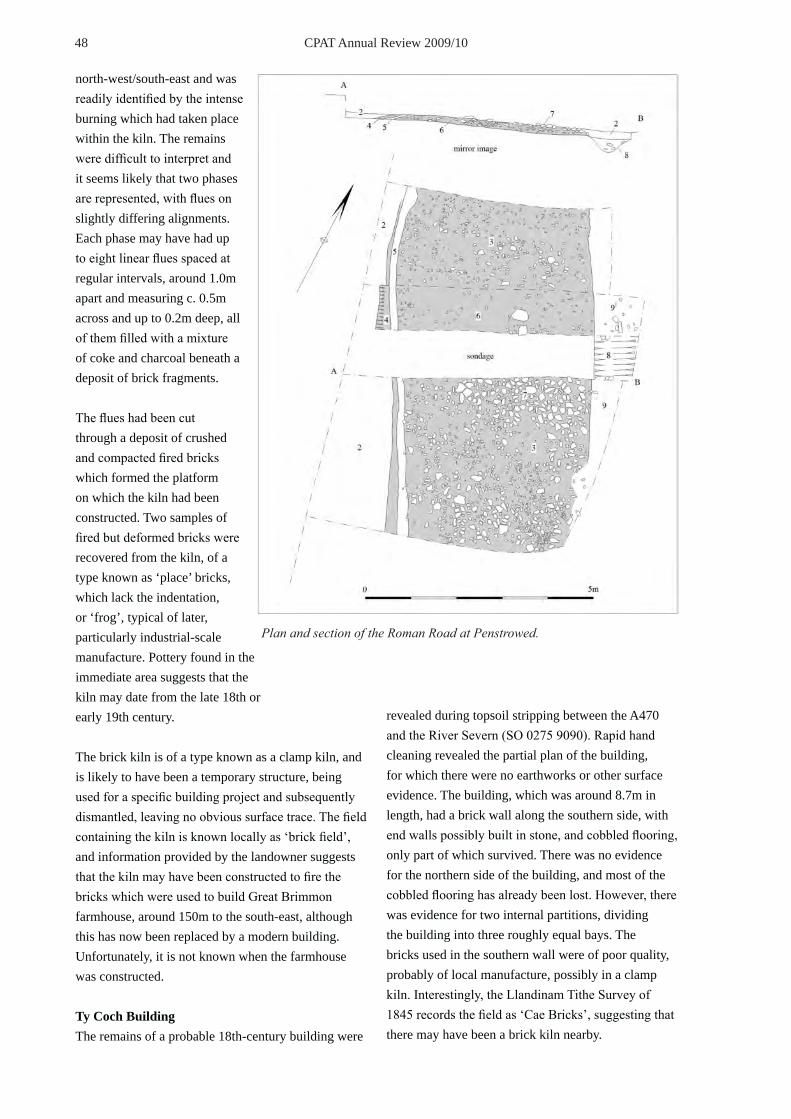
48 CPAT Annual Review 2009/10
north-west/south-east and was readily identified by the intense burning which had taken place within the kiln. The remains were difficult to interpret and it seems likely that two phases are represented, with flues on slightly differing alignments. Each phase may have had up to eight linear flues spaced at regular intervals, around 1.0m apart and measuring c. 0.5m across and up to 0.2m deep, all of them filled with a mixture of coke and charcoal beneath a deposit of brick fragments.
The flues had been cut through a deposit of crushed and compacted fired bricks which formed the platform on which the kiln had been constructed. Two samples of fired but deformed bricks were recovered from the kiln, of a type known as ‘place’ bricks, which lack the indentation, or ‘frog’, typical of later, particularly industrial-scale manufacture. Pottery found in the immediate area suggests that the kiln may date from the late 18th or early 19th century.
The brick kiln is of a type known as a clamp kiln, and is likely to have been a temporary structure, being used for a specific building project and subsequently dismantled, leaving no obvious surface trace. The field containing the kiln is known locally as ‘brick field’, and information provided by the landowner suggests that the kiln may have been constructed to fire the bricks which were used to build Great Brimmon farmhouse, around 150m to the south-east, although this has now been replaced by a modern building. Unfortunately, it is not known when the farmhouse was constructed.
Ty Coch BuildingThe remains of a probable 18th-century building were
revealed during topsoil stripping between the A470 and the River Severn (SO 0275 9090). Rapid hand cleaning revealed the partial plan of the building, for which there were no earthworks or other surface evidence. The building, which was around 8.7m in length, had a brick wall along the southern side, with end walls possibly built in stone, and cobbled flooring, only part of which survived. There was no evidence for the northern side of the building, and most of the cobbled flooring has already been lost. However, there was evidence for two internal partitions, dividing the building into three roughly equal bays. The bricks used in the southern wall were of poor quality, probably of local manufacture, possibly in a clamp kiln. Interestingly, the Llandinam Tithe Survey of 1845 records the field as ‘Cae Bricks’, suggesting that there may have been a brick kiln nearby.
Plan and section of the Roman Road at Penstrowed.
49 CPAT Annual Review 2009/10
Ffridd Wood BuildingTopsoiling operations between Penstrowed and Newtown revealed evidence for a possible building (SO 0763 9029). Three rows of edge-set bricks were identified, set on a bed of what appeared to be crushed brick, sealing a deposit of peat 50mm thick. The bricks had been laid in two directions, with a single row aligned east/west and a double row at right angles. The bricks appeared to be edging a deposit of crushed brick, which may have been laid as a floor. It was not possible to determine the full extent of the floor and no other structural features were identified.
FindsA range of post-medieval pottery, glass and clay pipe fragments were recovered from the topsoil during stripping operations, although these were only retained where they were thought to relate to a particular archaeological site. Among the topsoil finds was a fragment of perforated floor tile from a malting kiln, which was found around SO 04599174. There were also two significant finds which are worthy of particular attention. A small, convex thumbnail scraper was recovered during topsoiling at SO 03559 91201, and a single gold coin was recovered by a workman during trenching operations along one of the access roads on the Vastre Industrial Estate in Newtown (SO 1205 9173). The find was brought to the attention of CPAT who were monitoring groundworks in adjacent fields at the time of the discovery. The coin has been identified as a Noble, dating from the reign of Henry IV (1399-1413). It is in excellent condition and displays very little sign of having been in general circulation.
——Nigel Jones
SCHEDULING ENHANCEMENT PROGRAMMEFunding: CadwA programme of scheduling enhancement involving all the Welsh Archaeological Trusts was initiated by Cadw in 2008 to examine outstanding site types of prehistoric and Roman date not previously assessed in Wales. A series of enhancement programmes had, of course, already taken place during previous years, in some cases going back into the early 1990s, to study thematically a range of monument types including unenclosed prehistoric settlements identified through their lithic concentrations, prehistoric funerary and ritual monuments, round huts, defended enclosures
of Iron Age and Roman date, Roman military establishments and Roman roads. Such enhancement programmes were designed not only to identify sites which held sufficient potential to qualify them for scheduling as sites of national importance, but also to assist a rationalisation of the HER, through the validation of authentic sites and rejection of spurious examples, the amplification of existing records as necessary, and the removal of duplicate records. A scoping study in 2007/8 identified in general terms the number of sites and features in the regional Historic Environment Record (HER) that still needed to be assessed in order to complete the scheduling programme for prehistoric and Roman sites in the region, taking the study from the earliest times through to AD 400. The current programme initiated in 2008/9 was completed during the current year.
The preliminary study had identified over 1600 sites where assessment might be useful. Some site types such as burnt mounds and caves appeared to provide in themselves typologically discrete studies, but it was equally clear that there were some areas of east and north-east Wales where concentrations of various types of site suggested that a more geographically defined approach to both desk-top analysis and fieldwork might be a more efficient and economic mechanism for assessment. During the year four geographical areas and two morphological types were examined and these are reported on below. MINES AND QUARRIES CPAT Project 1583The metal mines of the region have been the subject of several past studies which were brought together in a CBA Research Report in 2004. Though chronologically wide-ranging, its focus was the mines of predominantly post-medieval date, yet some of these extraction sites had prehistoric or Roman origins. Prehistoric quarrying is more difficult to identify, even though there can be little doubt that it did occur within the region. Work on the stone axe factory at Hyssington in eastern Montgomeryshire, reported on in last year’s annual report and now prepared for publication, testifies to this. to assume that it was taken by simple methods from surface exposures of this material.
A significant proportion of the sporadic evidence for prehistoric metal mining belongs to the Bronze

50 CPAT Annual Review 2009/10
Age, when sources of copper were exploited for the manufacture of artefacts, tools and weapons. Known sites of the period include Nant yr Eira in western Montgomeryshire and, just outside the study area, the mines at Cwmystwyth in northern Ceredigion and at the Great Orme, near Llandudno. One of the features of Bronze Age mines is the presence of large numbers of hammerstones, and there is a report from the 1920s of such stones along with charcoal and burnt stone from fire-setting on spoil tips next to a narrow open working at the Nantyricket mine near Llanidloes. In some cases, it is possible to identify mines which are potentially associated with settlements, the most significant example being Llanymynech Ogof, in northern Montgomeryshire, which lies within the largest hillfort in Wales. The underground workings here are of particular interest as the absence of hammerstones would favour Iron Age and Roman mining. Open workings which are perhaps of similar date extend for at least 250m to the north, west, and south-west from the known mine and the antiquity of these workings is suggested by evidence of smelting dating from the last centuries BC uncovered during excavations in widely spaced parts of the fort over the years. For the Roman period, examples of mining include Ffrith, near Wrexham, and Prestatyn on the north coast, and these may have been controlled by the military which is implicit in the Roman fortlet at Penycrocbren close to the early lead workings at Dyfngwm/Castle Rock, north-west of Llanidloes. Other candidates for mines of Roman date include Ffos-y-bleiddiad, where there is a large opencut of early date, in close proximity to the Iron Age hillfort of Castell Cawr, and Graig Fawr, near Prestatyn where the hill is adjacent to the mines at Talargoch where finds of Roman date were made from the 18th century onwards.
As a result of the study three sites that were probably exploited during the prehistoric or Roman eras have been recommended for statutory designation.
BLACK MOUNTAINS CPAT Project 1584The Black Mountains in the south of our region and lying to the east of the Brecon Beacons included over 600 sites whose records required assessment. Some 170 records in the HER were enhanced, around half
of which were substantive changes.
In the northern reaches of the Vale of Ewyas a potential prehistoric enclosure was found to be of medieval date, while sites of other periods included a fine post-medieval farm complex, possibly with a medieval predecessor nearby, and significant numbers of scooped mounds. Fieldwork on Partrishow common, an area also recently covered under the Royal Commission’s Upland Initiative, was visited because of its known prehistoric usage and the presence of a possible cairnfield. While this proved unproductive, six new medieval house/structure platforms were identified including two very fine, deeply cut, house platforms surrounded by a relict field system and these are being recommended for scheduling as they are more than the equal of some of the other platforms that have already been designated on Partrishow Hill. There were also several unexplained features including two small, stony sub-rectangular platforms.
In the valley of Cwm Banw, fieldwork was confined to the east-facing slopes, where features of potential prehistoric interest had been recorded by the late Graham Makepeace. Some but not all of the features had been assessed during the Round Huts project. One enclosure turned out to be of medieval origin, containing a number of rectangular structures in the long hut tradition, while the alleged association of another enclosure with a prehistoric hut circle proved to be incorrect, although the site is still potentially prehistoric in date. Moreover, vertical aerial photographic coverage for the locality revealed a further enclosure and both have been recommended for statutory designation.
Where Cwm Rhiangoll merges with the valley of the river Usk, it is overlooked on the east side by the mountain summit of Pen Cerrig-calch. The western slopes of this mountain form a series of shelves descending into the minor tributary valley of Cwm Gu, where a prehistoric settlement site comprising two hut circles and an enclosure was recorded under the Round Huts project some years ago. Vertical aerial photographic coverage of the upper slopes, above the prehistoric settlement, revealed a significant area of linear stone stripes which appeared to represent a discrete field or enclosure system, even though

51 CPAT Annual Review 2009/10
this lies at about 550m OD, so it was considered possible that they might form an upper extension of the prehistoric activity already recorded. Nothing of obvious prehistoric date was found at this altitude but there was some ambivalent evidence of medieval or early post-medieval settlement and it is assumed that this is associated with the field system, though further survey is needed to confirm the date.
Sporadically, small earthworks of a distinctive type have been recorded in the Historic Environment Records from various upland localities across Wales. Essentially these consist of low mounds, usually several metres across, the material for which was scooped from one side, normally on the uphill side, leaving a hollow. Having been termed scoop graves and thought by Aileen Fox back in the 1930s to be of prehistoric date, these were discussed at an early stage by the co-ordinating group of the Cadw-funded prehistoric funerary and ritual monument survey in the late 1990s,
Scooped mound on Cefn Foel in the Black Mountains
Vertical aerial photograph of Pen Cerrig Calch.© Next Perspectives. Welsh Assembly Government 2009.

52 CPAT Annual Review 2009/10
and dismissed as authentic prehistoric features. In itself this was perfectly logical, but the corollary was that the term ‘scoop grave’ was then dropped from the thesaurus of terms used in the HER in favour of the much broader term ‘mound’ with the result that it was no longer possible readily to detect where these particular earthworks have been recognised and recorded in the past. ‘Scoop graves’ are particularly prevalent in the Black Mountains, and the opportunity to summarise the existing evidence and enhance the HER was taken during this scheduling enhancement programme. Though we should perhaps be wary of seeking a single, all-encompassing explanation for these features, the most plausible explanation is that they have been dug by troops on military manoeuvres
ELAN VALLEY CPAT Project 1585The Elan Valley area of western Powys contains a high proportion of sites that are of either prehistoric funerary and ritual origin or medieval and post-medieval rural settlement, both former pan-Wales projects, and for this reason alone, the number of HER entries that required assessment was not as large as for some other areas examined under the Scheduling Enhancement Programme. Though there is virtually no known Roman activity, other than the temporary military camp on Esgair Perfedd, there are perhaps more potential prehistoric occupation sites of open character here than in some other upland areas of mid Wales.
Relatively few records required enhancing – less than thirty with another fifty seeing very small modifications. Several field visits produced more substantive results. The Lan Fawr stone was omitted from the prehistoric funerary and ritual study, probably because the Ordnance Survey were unable to locate it in forestry in 1977. A cursory examination of recent vertical aerial photography, however, revealed a possible contender in a clearing a couple of hundred metres to the east of the given grid reference. The large stone lay in a clearing and forestry workers had created an approach track to it. The stone itself looks like a natural boulder, though of considerable size, but it evidently impressed the forestry workers who had put lumps of quartz in a circle on its surface. More important is the imposing stone in Llanwrthwl churchyard which was probably overlooked because of its setting. Tradition has it that St Wrthwl founded
his church here because of the stone and while there is no way of proving this to be true, there can also be no doubt that this stone is deliberately set up and in the absence of any form of inscription or symbol, a prehistoric date must be assumed. As such it should surely be scheduled, even though it is on sacred ground. The small mounds on Esgair Rhiwlan remain an enigma. Their landscape location militates their interpretation as a cairnfield and they do not have the ‘feel’ of prehistoric burial cairns, being too small and irregular and well-spread out across the ridge; their appearance as mounds rather than pits does not favour the suggestion that they are the result of military firing or bombing practice. As far as can be established on the evidence available, there are no comparable sites locally. The Allt Goch cairnfield is more straightforward, for there can be little doubt that
The megalithic Stone in Llanwrthwl churchyard.

53 CPAT Annual Review 2009/10
the cairns were the product of agricultural clearance in the prehistoric era. Unfortunately, there is virtually no associated evidence which might have enhanced the prospects of scheduling on these moorland shelves, and the only possible hut site is too small and incomplete to merit scheduling in its own right. There are several records of the Allt Goch Cairnfield, one of them wildly misleading. It proved impossible to correlate all of the cairns that were seen during the visit and were registered using GPS with the existing records, but some were, and we have thus rationalised the record to an acceptable degree.
As to why the Crugiau Bach Enclosure was not scheduled when the adjacent stone circle was afforded that protection is unclear. Had it been clearly flagged up in the HER when CPAT was examining prehistoric house sites in Breconshiure a couple of years ago, it would probably have been recommended. However, it is not actually a house site, more an enclosure in which an otherwise invisible hut was set.
Finally, we might note in a slightly flippant vein how records once created, and regardless of their integrity, are encased in stone, never to be excised from the record. The Nant y Fedw enclosure is claimed ‘as a square enclosure with large beds’, intriguing in itself, and the source is given as the RCAHMW archive. Despite our careful search and assistance from the Royal Commission staff in the NMR, no trace of this archival record can be recognised. A ghost site has been created, and we shall probably never clarify the nature of the large beds.
SEVERN VALLEY CPAT Project 1586The Severn Valley study produced no new recommendations for scheduling. With a high percentage of cropmarks and considerable work on particular site types over the last few years, this should come as no surprise.
Pit alignments belong to a class of monument which has not been considered under other programmes of scheduling enhancement, and while none of these pits has provided dating evidence, but a late Bronze Age or early Iron Age origin has been suggested. The widespread nature of the alignments and the fairly intensive cultivation which characterises the area creates difficulties in considering the merits of
statutory protection and arguably a more strategic and specifically focused overview needs to be taken of such systems, looking at the evidence from Wales as a whole rather than from a single region.
Of sites that were visited, a significant proportion could either not be located or proved to be unrelated to the study period. One example of the latter was the Middletown Quarry (PRN 4515), which is situated on the small knoll lying between Moel y Golfa and Middletown Hill in the Breiddin Hills, and where the original record suggested that the earthworks might represent a hillfort. Given that there are a number of prehistoric enclosures in the locality, this was worth further examination but its resemblance to a hillfort was entirely fortuitous and only evident from the Middletown Hill side. Its nature was confirmed by the spoil which had been left and the irregular base of the excavated hollows. Similarly, a site of potential interest was the Maes y Gwastad platform on the outskirts of Welshpool, where the earthworks had been seen as potentially late prehistoric or Roman and even compared to a Roman fort. The site comprises a levelled platform on the crest of a broad ridge, but the earthworks are only present on two sides, so the site is not defensive and certainly not Roman from its appearance. More probably it represents a 19th-century military encampment, as it is known that the local militia used the area as a training ground.
One of the positive discoveries was the Black Gate enclosure near Dolfor, which had been effectively dismissed in the past as an aberrant mark on an aerial photograph, but proved to be a sub-circular earthwork enclosure. This lay on a very gentle slope at the natural saddle/watershed between the Mule and Ithon river catchments and was approximately 45m in diameter, defined by a low bank about 4m-5m wide and up to 0.4m high, with hints of an external ditch. A possible entrance gap, 5m wide, lay on the SW side. A linear parchmark seen on a 1967 Cambridge aerial photograph of the floor of the Severn Valley, near Berriew had been recorded in the HER as a probable former field boundary. Heading directly towards the fort at Forden, there was a possibility that it signalled a Roman road running towards Forden Gaer from Caer Gai. A field visit failed to identify any definite trace of the feature. One new site was a possible fish weir composed of two parallel rows of oak posts, each

54 CPAT Annual Review 2009/10
about the size of modern fencing posts, projecting from the waters of the river Vyrnwy.
MYNYDD HIRAETHOG CPAT Project 1587Mynydd Hiraethog offers rather less scope for identifying significant sites than the other areas studied over the last eighteen months, for archaeologically it is one of the less interesting upland blocks in east Wales. This is not to downplay the value and interest of the Brenig prehistoric sites and from a later era Hen Ddinbych and Hafod Nant y Criafolen; rather it is a statement on the totality of the archaeology that is to be found here, particularly on the western moors. Fewer than forty records were enhanced, and no scheduling records have been made. There are hints though that the high moors are the wrong place to be looking for the informative remains of the past – the lower slopes below the high ground, long enclosed for agrarian purposes, is where the interesting archaeology resides. There is the complex of earthworks north of the A5 which has been termed Fron Bellaf and which we drew attention to more than ten years ago; these are probably medieval but a prehistoric element cannot be ruled out. There are the two curious monuments at Ffridd Can Awen, just north of Pentrefoelas and at Hafod-y-dre about seven hundred metres to the east. The former comprises around 450 small stones protruding generally no more than 0.1m high from the ground and set in irregular rows over an area less than one hundred metres square; excavations in 1884 uncovered burials in three cists but these are now visible only as shallow depressions in the ground. The Hafod-y-dre stones form rows that have recently been re-surveyed by the Royal Commission and will be published in their book on Hiraethog. And there are other sites which have come within the purview of this project. The Ty Tan-y-foel platforms are significant because they represent one of the very few proven physical manifestations of open settlement in the pre-Roman Iron Age from north-east Wales. It is deeply regrettable that the National Museum has not been able to muster the resources to publish their excavations there. There is too an enclosure which lies surrounded by the turbines of the Tir Mostyn windfarm south of the A543 which crosses the moors towards Denbigh. We have termed this the Marial Gwyn enclosure. It was first discovered through the Royal Commission’s aerial photography
in 2007, and in this respect highlights the inadequacy of the environmental impact assessment that had been conducted for the windfarm several years earlier. It could be a seasonal settlement of medieval date or a small late prehistoric homestead enclosure, and it is the latter that we tend to favour. It lies in enclosed pasture, and it is the agricultural improvement that has occurred here that prevents a scheduling recommendation.
BURNT MOUNDS CPAT Project 1589Burnt mounds have been a recognised site type for many years, and various interpretations continue to emerge. In the west Midlands in the 1980s Lawrence Barfield and Mike Hodder argued that many had been prehistoric saunas, articulating their theory in the interestingly titled Burnt Mounds and Hot Stone Technology (1991). Much more recently in Ireland it has been suggested that burnt mounds were a by-product of beer-making in prehistoric times, an idea that has been taken up enthusiastically in Gwynedd as revealed in the pagers of a recent edition of British Archaeology. More traditional is the belief that many burnt mounds were waste from the cooking process, with water being heated with stones from a fire that shattered when put into the trough, trench or pit that had been dug, the food being put in the water to cook, and the stones ultimately discarded in a mound around the trough. This resulted in the diagnostic kidney-shaped form of the classic burnt mound.
What stand out is that east Wales is not apparently liberally endowed with burnt mounds. Compared with west Wales we have very few recorded examples, and this is a phenomenon that is difficult to explain. There is also some confusion in the HER as a result of the tendency to shoehorn past discoveries not only into a category of hearths and fire or fired pits but also cite the term ‘burnt mound’ as an alternative as though it was a generic term for any feature whose content included burnt stone. This is clearly demonstrated by the recent work at Dinorben near Abergele in north Wales, where the excavators have classed pits filled with fire-cracked stone as burnt mounds, even though from the interim reports there were no visible mounds to be seen prior to excavation. It might be reasonable to assume that over the centuries any mounds that were associated with the activity have been levelled out, leaving only the pit fills as testimony to the
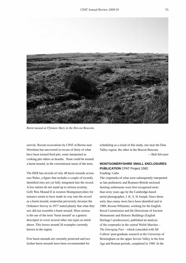
55 CPAT Annual Review 2009/10
Burnt mound at Ffynnon Mary in the Brecon Beacons.
activity. Recent excavations by CPAT at Borras near Wrexham has uncovered in excess of thirty of what have been termed fired pits, some interpreted as cooking pits others as hearths. None could be termed a burnt mound, in the conventional sense of the term. The HER has records of only 48 burnt mounds across east Wales, a figure that includes a couple of recently identified sites not yet fully integrated into the record. A few entries do not stand up to serious scrutiny. Gelli Wen Mound II in western Montgomeryshire for instance seems to have made its way into the record as a burnt mound, somewhat perversely, because the Ordnance Survey in 1977 stated plainly that what they saw did not resemble a burnt mound. More serious is the use of the term ’burnt mound’ as a generic descriptor to cover several other site types as noted above. This leaves around 26 examples currently known in the region.
Five burnt mounds are currently protected and two further burnt mounds have been recommended for
scheduling as a result of this study, one near the Elan Valley region, the other in the Brecon Beacons. —Bob Silvester
MONTGOMERYSHIRE SMALL ENCLOSURES PUBLICATION CPAT Project 1582Funding: CadwThe cropmarks of what were subsequently interpreted as late prehistoric and Romano-British enclosed farming settlements were first recognised more than sixty years ago by the Cambridge-based aerial photographer, J. K. S. St Joseph. Since those early days many more have been identified and in 1989, Rowan Whimster, working for the English Royal Commission and the Directorate of Ancient Monuments and Historic Buildings (English Heritage’s predecessor), published an analysis of the cropmarks in the central Welsh Marches – The Emerging Past – which coincided with Jill Collens’ post-graduate research at the University of Birmingham on the upper Severn Valley in the Iron Age and Roman periods, completed in 1988. In the

56 CPAT Annual Review 2009/10
early 1990s CPAT with funding from Cadw undertook its own assessment of the cropmark enclosures in Montgomeryshire, plotting individual sites against Ordnance Survey mapping, and visiting the locations of cropmark enclosures to identify above-ground survivals, and this resulted in an internal report in 1993. Furthermore, small trial excavations were conducted on seven sites in the Llandyssil area near Montgomeryshire in 1993/4. The paper prepared for publication, probably in the local county journal, pulls together the evidence from the field visits and the trial excavations in the 1990s, and the geophysical surveys between 2006 and 2008, all funded by Cadw. In addition a separate internal report has been prepared detailing the seven excavations and their results (CPAT Report no 1042). The number of cropmark enclosures that has been recognised in Montgomeryshire currently stands at about 190, a reasonably precise figure which excludes another 80 or so sites where the photographic evidence is equivocal. Their distribution is far from even across the county and indeed is weighted almost exclusively to the eastern half, concentrating along the Severn Valley itself, extending into the lower reaches of its main tributaries, the Tanat, Vyrnwy, Rhiw and, converging on it from the east, the Camlad. Beyond these valleys numbers drop dramatically, and central and western Montgomeryshire is largely a blank. Even the Dyfi Valley above Machynlleth in the extreme west has failed to produce any convincing cropmarks. Complementing the distribution pattern of cropmark enclosures are the smaller enclosures which survive as earthworks. They are generally found away from the low-lying valley areas where cropmarks are prevalent, and on the higher valley sides where their distribution overlaps that of the cropmark enclosures. However they also spread out further, higher up the Vyrnwy and Banwy, and into the hills below the Kerry ridge. Western Montgomeryshire is again devoid of recorded examples but aside from the high watershed between the Severn and Dovey drainage systems which would never have formed an attractive environment for settlement, it is likely that a paucity of fieldwork could be responsible for the apparent absence of such sites. Certainly Iron Age hillforts have a wider distribution in the west and south of the county, implying amongst other things that these areas
were inhabited earlier in the Iron Age, and logically there is no reason to assume these areas would have been entirely deserted as individual enclosed farms became more prevalent. Aerial photography is of course only an initial stage in comprehending both the nature of the enclosed settlements themselves and also the wider patterns of farming and exploitation in the landscape. Aerial discoveries of new sites are now tailing off, though there remains an assumption that exceptionally dry summers will add further examples to the corpus of sites as happened in 1989 and 1990. It is the other archaeological methods that are beginning to fill out the picture.
Fieldwork has demonstrated that the distinction between cropmark and earthwork enclosures is not as simple as it might appear. This was apparent at Collfryn, excavated in 1980, which is still the most thoroughly examined enclosure in the county. Identified from the air through its cropmarks, Collfryn is also defined by its relict earthworks, and was probably the first of what is now a total of over thirty cropmark enclosures which can be recognised on the ground, the surface evidence complementing the aerial view. These enclosures exhibit the transition at ground surface level from three to two-dimensional form – they are cropmarks in the making – and represent nearly 20% of the enclosures first photographed from the air. But there is no even spread across the site types. And their geographical locations reinforce the transition for while a very few of them are to be found in the valleys most are higher up the slopes, admittedly intermixed with true cropmark enclosures in the middle reaches of the Montgomeryshire Severn, but elsewhere as in the valley of the Cain, on the fringes of the cropmark distribution. The results of the limited excavations on seven sites broadly confirmed expectations but were not particularly productive. The approach in each case was to excavate a radial trial trench which where possible extended across the innermost ditch, across the line of the assumed inner bank inside it and extending just into the interior of the enclosure. Most informative was the Mount Pleasant enclosure where the base of the inner rampart just over 3 metres wide, survived to a height of 0.4 metre, and behind it were the truncated remains of a hearth and two postholes possibly

57 CPAT Annual Review 2009/10
Mount Pleasant enclosure, Llandyssil, Montgomeryshire.

58 CPAT Annual Review 2009/10
representing a four-post structure containing charcoal that has been provided radiocarbon dates of 484–170 cal. BC (SWAN-11) and 401–119 cal. BC (SWAN-12). Charred plant remains from the hearth and buried soil included sparse grains of spelt wheat.
Geophysical surveys have been conducted on seventeen enclosures along the Severn Valley from Berriew as far north as Guilsfield, with solitary exceptions in Churchstoke and Kerry. The primary purpose of that work was to determine how much additional information could be gleaned from geophysics on enclosures already plotted from aerial photographs, and the value of the technique has been to add detail to an incomplete picture. Thus the Tyn-y-coed enclosure in Berriew is set astride a narrow ridge, and parchmarks displayed no more than an entrance defined by its ditch terminals and, 65m away, a short length of ditch on the far side of the enclosure, both of these showing on the thin soils of the ridge top. Geophysics successfully defined almost the entire perimeter. The most surprising geophysical survey, however, was that at Dol-lâs which from aerial photography was postulated as a potential cursus. This is now seen to be a complete double-ditched enclosure with a mass of internal detail
The picture that emerges is that the enclosures in the Severn Valley are of fundamental importance to the late prehistoric and Roman era: they are the defining elements of settlement, occupation and the farming economy for a period of a millennium and perhaps more. The discovery of this seemingly intensively farmed landscape ranks as one of the major achievements of aerial photography in Wales and the Marches over the last half a century. Work on the enclosures, albeit sporadic, has been going on now for sixty years, and will long continue into the future, but needs to be seen against a background of continuing
plough damage and gradual degradation. It is evident that aerial photography still has much to contribute, but above all excavation is also required, and while any large-scale examination must be welcome, arguably the emphasis should be on the smaller univallate enclosures which are currently under-examined in the record. The study is still in its infancy, and considerably more research is needed before some of the important questions can be answered. ——Bob Silvester
LLANELWEDD CORN-DRYING KILN AND FARMHOUSE CPAT Project 1588Following on the excavation of two Bronze Age burial cairns at Llanelwedd in 2007 and 2008, the focus of work in 2009, funded by Cadw, was the remains of an abandoned farmstead within the quarrying concession, associated with the corn-drying kiln excavated in 2008. The upland farm, probably founded in about the later seventeenth century, had evidently been abandoned by the later eighteenth or early nineteenth century. It had clearly been deserted by the time the Llanelwedd tithe map of 1845 was drawn up, and no record of the name of the farm or its occupants have yet been traced. The farm lay at one corner of a large field called ‘Pen-y-graig’ enclosing part of rocky summit of the Carneddau hills, the name which

59 CPAT Annual Review 2009/10
has been adopted for the abandoned farm. The main building is a longhouse, perhaps the first of its kind to be excavated in Radnorshire, can be closely paralleled at a number of surviving houses in the county, described in Richard Suggett’s authoritative Houses & History in the March of Wales. Radnorshire 1400-1800 published by the Royal Commission. Part of the importance of the Pen-y-graig farm complex is that it has offered the opportunity of examining a relatively short-lived farm complex, undisturbed by building work in the later nineteenth and twentieth centuries. The farmhouse, which lay on the uphill side of the longhouse, had been partly terraced into the slope of the hill. The upper gable wall was of locally-quarried stone bonded with clay. It included the remains of a fireplace and chimney backing onto the slope of the hill. Spiral stairs to one side of the fire gave access to an upper floor and probably confined to the roof space. The absence of roof tiles or slates on the site suggests
that the roof was thatched.
A second, slightly larger stone fireplace and chimney was found at the lower end of the farmhouse, to one side of which was a doorway leading into a cowhouse below. A circular bread oven had been added to this second fireplace, perhaps replacing the external oven forming part of the Llanelwedd corn-drying kiln. Unlike the end walls, the side walls of the farmhouse and the cowhouse below it were evidently of timber-framed construction set on low stone sill walls. It proved impossible to complete the excavation of the interior of the farmhouse due to the unprecedented wet weather in November 2009, but a return is now planned for the spring of 2010. There are already indications that the farmhouse was divided into a number of different rooms, possibly with a parlour with a slightly higher earth floor at the upper end and a kitchen, partly paved with stone, at the lower
Llanelwedd farmhouse during the course of excavation. Note the added bread oven in the foreground and the fireplace in the background.

60 CPAT Annual Review 2009/10
end. Pen-y-graig can now be seen to have included a longhouse, a possible cartshed to the west (probably also of timber-framed construction), the corn-drying kiln to the south, and possibly other structures. The farm was probably associated with the embanked enclosure, shown on the tithe map, that had been carved out of the upland common on the southern end of Carneddau in about the later seventeenth century. Its economy probably depended upon cattle and sheep farming as well as cereal cultivation. The growing of perhaps barley and rye on small flatter areas of cultivatable land scattered amongst the rocky outcrops on the hill is clearly denoted by the corn-drying kiln as well as by a scattering of clearance cairns, including those which overlay the two excavated Bronze Age burial cairns. The farm was no doubt deliberately sited next to a natural pond, representing one of the few sources of water on the summit of Carneddau. Parts of the pond may well have been artificially deepened as a source of clay for building work. Relatively few stratified finds have so far been recovered but, interestingly, appear to include a preponderance of fine wares, including early tea wares and the slipware sherds shown here.
——Bill Britnell
ROMAN MILITARY VICI ASSESSMENT CPAT Project 1590Funding: CadwThe military vici assessment was formulated as a two to three-year project focusing on the six best-known civilian settlements in the Clwyd-Powys area: Brecon Gaer, Caersws, Castell Collen, Forden Gaer, Hindwell and Pen-y-gaer. The initial focus was on two of the six: Caersws where it was planned to pull together the results from numerous pieces of small-scale developer-led work over the last fifteen years or so to produce a synthesis of present knowledge of the vicus which could address specific research agenda issues and also inform future planning policy; and Pen-y-gaer where it was hoped to examine further a building revealed in a small evaluation in 2007, and also involve local volunteers in the work. The work on Pen-y-gaer was postponed at the request of Cadw who had concerns about the impact of continuing metal-detecting at Brecon Gaer, and as a result work was undertaken there.
Caersws, MontgomeryshireAs part of the military vici assessment an article has been prepared for Montgomeryshire Collections, summarising the results from a series of archaeological investigations since 1993. This follows on from two papers published in the same journal which synthesised the information produced by various pieces of work undertaken within and around the two Roman forts at Caersws and the associated civilian settlement, or vicus, between 1984 and 1993 (Jones 1993; 1996).
During the past thirty years Caersws has seen considerably more in the way of archaeological investigations than any other auxiliary fort in mid-Wales. This results from the position of Caersws II fort and vicus, much of which lies beneath the modern settlement, the continuing development of which has afforded frequent opportunities to examine the underlying archaeology. Comparable military sites such as at Forden Gaer, Brecon Gaer and Castell Collen, near Llandrindod Wells are mostly in farmland, impinged by only a few farm buildings.
That said, however, there have been no large-scale excavations since 1993 as the preservation of historic remains have now become an integral part of the planning process. Over a sixteen-year period there have been thirty-eight archaeological investigations in Caersws since the last summary report (Jones 1993), of which four have been geophysical surveys while small-scale excavations and watching briefs each number seventeen. Of these, there have only been twenty-one occasions when evidence for Roman activity has been recognised. This is not, however, as unpromising a statistic as it might appear as the existence of negative evidence has itself helped to redefine the likely extent of the vicus.
Where Roman deposits have been encountered some have served merely to confirm our existing knowledge, while others have provided significant new information. There is now evidence for smithing activity on at least two sites within the vicus, in the area of the Old Primary School, and adjacent to the telephone exchange along Manthrig Lane. This fits well with the idea that much of the civilian settlement was essentially a commercial enterprise with

61 CPAT Annual Review 2009/10
numerous shops and small workshops.
The lifespan of the vicus still remains uncertain. Activity probably commenced not long after the foundation of the fort in the late 1st century AD, while the 1985-6 excavations (Britnell 1989) imply that the commercial centre of the settlement, outside the south gate, or porta praetoria, was in decline by as early as AD 130. This reflects the general pattern in Wales as a whole where the inhabitants of the vici do not appear to have forged sufficient ties with the native population to allow them to develop into independent villages or towns before the military presence was scaled down and troops were withdrawn in the Hadrianic to Antonine period (Britnell 1989, 127). There is, however, evidence for activity continuing in some form into the 3rd century, when a succession of timber buildings were sealed beneath a stone spread and then a deliberate dump of clay. Deposits identified by the telephone exchange appear to confirm this sequence.
Yet while parts of the vicus appear to have been in decline by the mid-2nd century, the succession of timber buildings at Greenlands continued into the 3rd century. There is now also evidence for some later activity, possibly in the form of ribbon development, along the side of the road leading eastwards from the fort, at least 300m beyond the defences. Unfortunately, the scale of excavations at Glan-y-nant was insufficient to allow any more definite conclusions regarding the nature and precise dating of the activity there.
Although excavations have been conducted in Caersws for more than 150 years, it is clear that much still remains to be discovered and, despite the rather small-scale and piecemeal nature of most current archaeological investigations, future work has the potential for revealing important new information, particularly with regard to the vicus.
ReferencesJones, N. W., 1993. Caersws Roman Fort and
Vicus, Montgomeryshire, Powys, 1984-92. Montgomeryshire Collections 81, 15-96.
Jones, N. W., 1996. Excavations within the Roman vicus at Caersws, 1989-93. Montgomeryshire Collections 84, 1-36.
——Nigel Jones
Brecon GaerGeophysics carried out by the Trust in 2005 and 2006 around the periphery of the fort at Brecon Gaer revealed significant activity along the road leading from the fort’s northern gate, additional to those examined by Mortimer Wheeler in the 1920s. In contrast, there was only patchy traces of activity outside the south and west gates, while the flat field to the east of the fort was surprisingly almost featureless. Metal-detecting in the unscheduled eastern field at some point after the geophysical survey had been completed presented a different picture, with the recovered metalwork representing a significant collection that included items that could reflect local pre-Roman Iron Age metalworking traditions still current at the time of the Roman military penetration of Wales.
To resolve this dichotomy, a strategy was developed of small-scale test pitting, taken down to the top of any existing archaeological levels, supplemented by the augering of selected areas between the pits. Each
One of the trial pits excavated to try and define the area of the vicus next to Brecon Gaer Roman fort.

62 CPAT Annual Review 2009/10
Areas of geophysical survey by CPAT superimposed upon the fort plan of Brecon Gaer Roman fort. The survey identified the Roman road with buildings belonging to the vicus to the north of the fort, but the area just to the east of the fort appeared blank.

63 CPAT Annual Review 2009/10
Trial pits excavated to the north and east of the Brecon Gaer Roman fort dug to try and define the extent of the vicus settlement.
trench and auger hole was located by EDM survey, thus establishing their precise positions in relation to the local field boundaries, the geophysical plots and, where they had been recorded, the metal-detecting finds.
While four of the test pits and a couple of auger holes
were placed in the fields to the north of the fort in order to answer specific questions about the presence of deposits associated with the vici as viewed through the geophysics results, a larger number of pits were dug in the field to the east of the fort. Ten pits and one line of auger holes were placed regularly across

64 CPAT Annual Review 2009/10
the entire field and revealed traces of Roman activity in almost every part, except for the extreme south-eastern corner. Even there, however, there was Roman material in the ploughsoil implying that vicus activity was nearby.
The purpose of this approach was not to establish the nature of the activity in the vicus for that could only be achieved though much more extensive excavations but to determine its presence or absence in order to aid Cadw in their scheduling strategy of Brecon Gaer. In this respect the approach has been very successful and also cost-effective, and it is anticipated that it will be extended to other areas around the fort during the present year. Nevertheless, some new information on the activity around Brecon Gaer has come to light. A useful collection of Samian ware fragments were recovered, most of which appear to be later 1st century or early 2nd in date according to Peter Webster. And in one test pit, a ditch or gully was revealed where the Roman occupation layer formed one of the later fills. This suggests that the ditch was very early in date, certainly belonging to the earliest period of Roman activity, or perhaps even of pre-Roman origin.
——Bob Silvester
MEDIEVAL CROSSES AND CROSSHEADS Project 1592Funding: CadwThe spur to this study centres on the superb medieval churchyard crosshead at Tremeirchion in Denbighshire which was sold by the churchwardens in 1863 and found a new home at St Bueno’s monastery in the same parish. In 2004 the monastery’s authorities decided to offer it back to the church at Tremeirchion, and the parish authorities re-erected it, but on an incongruously short shaft under a yew tree where it is increasingly covered by mould; had it been scheduled in 2004, its present fate might have been different.
With this as a background this study examined the extant crosses and crossheads in east and north-east Wales, their nature and status. The project was funded by Cadw and in general terms fits into the on-going programme of scheduling enhancement work which has been conducted by all the trusts over the last two years, albeit on sites and features of prehistoric and Roman date. Early medieval crosses were excluded
as these had already been covered in the Trust’s Early Medieval Ecclesiastical and Burial; Sites Study in 2002-4.
The region is not well-endowed with medieval crosses. Compared with Cornwall’s 700 surviving medieval crosses and more than one hundred in Herefordshire, the fifty or so crosses in our dataset for the whole of the east and north-east of Wales, quite a few of which are no longer extant, is a fairly small group. The only detailed study is Elias Owen’s late 19th-century book on Old Stone Crosses of the Vale of Clwyd, an intriguing little volume which demonstrates that Owen was a sympathetic antiquary and an acute observer.
Crosses have fulfilled various roles in the past. Any attempt rigidly to categorise a group of disparate crosses closely can develop into a frustrating exercise. Most writers seem to accept that a cross that was erected for a specific reason subsequently took on other roles as time passed. A churchyard cross for instance might become a preaching cross, a wayside cross might double up as a memorial cross and so on. And many crosses may only be classified because of their current location, and potentially then our modern
Maes-y-groes cross, Cilcain.

65 CPAT Annual Review 2009/10
perceptions of what a particular position might imply come into play.
Churchyard crossesChurchyard crosses form the most distinctive group of survivals, and most churchyards will undoubtedly have had a cross in them in the medieval era. Some might have been of wood, but the majority would have been of more durable stone. The patterns of survival in our region are intriguing, but it is perhaps unlikely that Elias Owen appreciated in the early 1880s that in the Vale of Clwyd he was dealing with one of the more remarkable groupings in the country, including scheduled crosses at Derwen, Trelawnyd and Llanrhudd. The only churchyard cross to remain in Montgomeryshire is at Pennant Melangell, and in Radnorshire the situation is but little better with cross bases at Gladestry, and Llanbedr Painscastle, and a shaft at Presteigne. Only in the valley of the Usk and its tributaries in Brecknock does the density pick up again. The earliest post-Conquest cross in the region is probably that at Corwen which has been attributed to the 12th century, but most of those that can be dated, usually on the basis of their form and decoration, are likely to be later, from the 14th or 15th centuries. Fieldwork has removed some churchyard crosses from the list of known survivals in Denbighshire and Flintshire. The short shaft at Overton-on-Dee is not likely to have come from a churchyard cross, and the stub at Marchwiel is not really convincing. In southern Powys no complete churchyard cross remains, and crossheads are non-existent. Llanfeugan has most of its shaft surviving, but generally it is the base that remains as at Llangattock and Cwmdu. Both of these exhibit small niches for the pyx, the vessel containing the Host on Palm Sunday.
Town and Market Crosses It was a widespread, standard practice in the Middle Ages to mark the presence of a market with a cross. Some towns had more than one cross. Brecon had no less than three – a high cross, a preaching cross and a market cross. Few have survived. Some became obstacles to traffic, others because they no longer had a function. In many cases there will be no guide to their locations. Holywell for instance has a Cross Street, but the location of the cross is not known. Rhuddlan had a cross whose position is tolerably well
Top: the Tremeirchion crosshead.Bottom: Llangattock cross shaft.

66 CPAT Annual Review 2009/10
known but which disappeared in the 19th century. Denbigh is exceptional, indeed perhaps unique in our region, for the survival of its cross. It has travelled around the town, yet in this there is an implication too that its past significance and importance has been appreciated by the town council, and it has now been re-sited behind the market hall in the town centre, a matter of a few metres from where it had been for many centuries.
Boundary crosses Crosses might mark the boundaries of ecclesiastical lands, could define the sanctuary of the church, and in a more overtly secular context, might mark the rights and lands of a borough as at Rhuddlan. Identifying examples today is much more difficult. Criccin Cross to the east of Rhuddlan is a probable example. Perambulating the parish bounds, usually in Rogation week, was a widespread communal practice in the medieval era. The custom was undoubtedly affected by the Reformation and the Puritan Revolution of the mid 17th century but continued in some places in a more secular form into the 19th century. The markers however survived less well. There is from our region one published record of perambulations of the bounds of Churchstoke parish in the early 18th century where crosses were cut or re-cut in the turf, and it is within this context that the anomalous crosses marked on the maps of commons in southern Radnorshire almost certainly fit. Wayside crosses These were set up on roads or at cross roads, or perhaps too at fords, as waymarkers but also for passing worshippers, and in due course for the burial of suicides. Some wayside crosses may have been set up as memorials, a visual method of remembrance, whether to individuals, or to their charitable works. Occasionally, monastic routes across the moors might be marked by crosses, though whether for monks or pilgrims is not always clear. The Pedlar’s Cross near Llanigon (scheduled) is probably beside an ancient track running southwards towards Llanthony Abbey, and it has been suggested that the 13th-century cross not too far away in St Martin’s church at Cwmyoy (also in Monmouthshire) was a wayside cross on the pilgrim’s way to St Davids. In a less obviously religious context, the cross base at Croes Farm to
the south-west of Gresford has been claimed as a wayside cross, even though there is uncertainty as to its original location. Much the same is true of several others, but in all cases the term ‘wayside cross’ has almost certainly been applied within the record in a generic sense, because the cross lies close to a road which may or may not have medieval antecedents.
Only a small number of crosses are currently scheduled in the region, with rather more listed. Of those churchyard crosses already designated, Derwen, and to a lesser extent Trelawnyd and Hanmer, are worthy examples, but for Llanrhudd the criteria are presumably the height of the shaft and the fact that it carries a small amount of decoration, for there is no crosshead surviving. To these we would now suggest adding the fine crosshead at Tremeirchion. For crosses outside the environs of the churchyard, there is little to consider. No cross or cross-inscribed stone stands out immediately as being worthy of statutory designation, although there are some which are no more damaged than Criccin Cross which is already scheduled ——Bob Silvester
LLANELIAN COMMUNITY EXCAVATION Project 1595 Funding: CPATA weekend excavation on features adjacent to the famous cursing well at Llanelian with volunteers from the Llandudno Local History Society was supervised by the Trust.
——Bob Silvester
WALTON MARCHING CAMP Project 1596Funding: DeveloperA watching brief was maintained during the installation of an underground electricity cable supplying a caravan site within the area of a scheduled marching camp at Walton in Powys (SJ 25625996; SAM Mg 138). No archaeological features or finds were revealed.
——Ian Grant
WREXHAM CHURCHYARDS Project 1597Funding: Northern Marches CymruA short well-attended course was held at Hanmer on exploring the history of a churchyard, involving both a
67 CPAT Annual Review 2009/10
lecture and practical training ——Bob Silvester
MASON’S YARD, RHAYADER Project 1600Funding: DeveloperA watching brief was maintained during groundworks associated with a new building on the south side of Bridge Street, Rhayader (SN 96866788). No significant archaeological features or deposits were observed.
——Nigel Jones
LLANYMYNECH GOLF CLUB Project 1605Funding: Llanymynech Golf ClubA watching brief was undertaken in February 2009 during groundworks within the scheduled area of Llanymynech Hillfort (Mg030), in connection with the construction of a golf driving range at Llanymynech Golf Club. The watching brief monitored the excavation of eight test pits, together with the removal of turf and topsoil in a test strip. The watching brief revealed no trace of any features or deposits associated with the Iron Age hillfort, although was evidence for a deposit of hillwash across the area.
——Ian Grant
EAGLES GLEN, FOUR CROSSES Project 1607Funding: DeveloperAn evaluation was undertaken in connection with proposals to rebuild a fire-damaged house on the northern extent of Four Crosses (SJ 26941893). The single trench, 1.5m wide and 10m long, was excavated across the predicted line of the Offa’s Dyke rampart. The evaluation produced no evidence for the survival of deposits associated with Offa’s Dyke, although there was evidence, in the form of ditches, gullies and surviving ground surfaces, to suggest potentially significant Romano-British activity in the immediate area.
——Ian Grant
BRYN AWEL, MONTGOMERY Project 1609Funding: DeveloperAn evaluation was undertaken in connection with proposals for a new dwelling in the grounds of Bryn Awel, Montgomery (SO 22359669). The site lies towards the northern side of the town, around 150m north of the Church of St Nicholas. The evaluation produced no direct evidence for medieval occupation
within the area investigated, although the results do suggest that the site was formerly part of two medieval burgage plots, divided by a shallow ditched boundary, presumably associated with properties fronting onto Princes Street.
——Ian Grant
MOUNT CLOSE, WELSHPOOL Project 1611Funding: DeveloperA small-scale evaluation was undertaken on the site of a vacant plot of land fronting onto the south side of Mount Street in Welshpool (SJ 22190761). The evaluation revealed that the streetfrontage had been disturbed by cellars, leaving little prospect of surviving medieval deposits.
——Richard Hankinson
KEEL BERRIEW PIPELINE Project 1612Funding: Severn Trent WaterA watching brief was maintained during topsoiling operations associated with the construction of a new watermain near Berriew, in Powys. The pipeline comprised two main sections, one following the western side of the A483 from Refail, near Berriew (SJ 1926400368), for nearly 2km as far as Lower Luggy (SJ 1993802086), and the other running for 2km to the east and north of Powis Castle, near Welshpool, from SJ 2227906181 to SJ 2134607051. Two further short sections of pipeline also fell under this scheme, one to the south-west of Newtown, between the Llandinam Trunk Main (SO 08739040) and the Hollies SR (SO 08818935), and the other at the northern end of the Llandinam Trunk Main at Abermule, from Rhosllyn Farm (SO 17059563) to Green Lane (SO 17349579).
The watching brief revealed little of archaeological significance, identifying only a post-medieval trackway and with the finds limited to a single flint and a scatter of medieval pottery. However, the coincidental discovery from cropmark evidence of a potential Neolithic cursus, which was identified independently by Mr Bob Jones, generated a programme of excavation in advance of pipelaying operations.
The excavations revealed two roughly parallel ditches around 48m apart and aligned north-west to south-east. The north-eastern ditch was 2.3m to 2.8m wide

68 CPAT Annual Review 2009/10
and 0.8m deep, with a profile which included a shelf along the north-eastern edge at a depth of 0.42m below the surface of the subsoil. The south-western ditch was more regular, around 2.2m wide and 0.65m deep. No artefactual evidence was discovered, although fragments of charcoal were recovered from the north-eastern ditch which produced radiocarbon dates of 3960-3780 cal. BC and 3660-3520 cal. BC or 3400-3380 cal. BC. However, it should be borne in mind that although the charcoal was recovered from the ditch fill this does not necessarily provide a date for the construction of the monument.
A single date of cal. AD 1040-1214 was forthcoming from the south-western ditch, which appears to be anomalous, although significant worm activity was noted during the excavation and the charcoal could therefore have been intrusive. Remnants of medieval stripfields survived in this area until the second half of the 18th century and are depicted on an estate map of the Berriew area from 1764. Although the map itself is not metrically accurate, it has been possible to rectify it against a modern map base, the results from which clearly demonstrate that the ditches of the presumed cursus follow a different alignment to the medieval field pattern.
The dates from the north-eastern ditch, together with a review of the available aerial photography for the area in question suggest that the ditches are likely to be part of a Neolithic cursus at least 320m in length and between 38m and 53m wide, with a squared terminal at the north-west end. Perhaps significantly, the terminal appears to enclosure a prominent elongated rise which may be a natural landform. The south-eastern terminal ditch has yet to be located, although the monument is unlikely to extend much further to the south-east as there is no trace of the ditches extending into the adjacent field which has produced very clear cropmarks in previous years.
The newly discovered cursus provides a significant addition to the nationally important complex of Neolithic and Bronze Age funerary and ritual monuments in the Dyffryn Lane area. This collection of monuments occupies the area on the western side of the River Severn, between its confluence with the Rhiw in the south and the Luggy Brook to the north. Apart from the cursus the earliest monuments
to have been dated in the group are both at Lower Luggy where radiocarbon dates suggest that the palisade trench surrounding an earthen long barrow and the ditch of an adjacent enclosure were both constructed between 3650 and 3350 cal. BC (Gibson 2006). The enclosure also saw later activity with a cremation dated to 3020-2700 cal. BC, which is broadly contemporary with a phase of pit deposition involving the burial of Peterborough Ware and burnt material revealed during recent excavations on the site of the multi-phase monument known as the Dyffryn Lane Henge (Gibson forthcoming). The Dyffryn Lane complex also includes at least nine ring ditches and two upstanding barrows, as well as the standing stone known as Maen Beuno and one, or possibly two timber halls which may be of Neolithic or just possibly early medieval date.
ReferencesGibson, A M, 2006. Excavations at a Neolithic
Enclosure at Lower Luggy, near Welshpool, Powys, Wales. Proceedings of the Prehistoric Society 72, 163-191. Proceedings of the Prehistoric Society.
Gibson, A M, forthcoming. Excavation and Survey at Dyffryn Lane Henge Complex, Powys.
——Nigel Jones
WAT’S DYKE, PENYFFORDD Project 1615Funding: SP Power Systems LtdA watching brief was maintained during the installation of an underground fibre optic cable crossing the line of Wat’s Dyke at Penyffordd, near Mold, in Flintshire (SJ 29526111). The cable route crossed the dyke at a point where no visible earthworks survived, the line of the dyke here marked only by a scarp topped by hedgerow (the lower ground lying to the west of this). The watching brief revealed the upper fill of the ditch along the western side of the dyke, which at this point measured 4.2m in width, although the depth of the trench was insufficient to identify the base of the ditch, or its lower silts.
——Wendy Owen
BORRAS QUARRY, WREXHAM Project 1616Funding: TarmacA watching brief was maintained during a second season of topsoil stripping associated with the

69 CPAT Annual Review 2009/10
Three phases of road construction were identified, each consisting of a deposit of compacted river gravel. The earliest phase had been constructed on a base of imported clay, with a road width of around 4.5m and was flanked by a single ditch on
expansion of the sand and gravel quarry at Borras, to the east of Wrexham. Stripping of an adjacent area in 2008 revealed a significant concentration of hearths, cooking pits, and other domestic features, some of which were associated with Neolithic pottery. The watching brief revealed that the prehistoric activity identified in 2008 extended further to the east, leading to the excavation of a large area.
——Richard Hankinson
TESCO NEWTOWN Project 1617Funding: Tesco plcA large-scale excavation was conducted from late May to late July 2009 in advance of a new Tesco supermarket development on the site of the former Smithfield livestock market in Newtown (SO 1145 9147). The excavation consisted of three separate areas all focusing on the projected line of the Roman road linking the forts at Caersws and Forden Gaer. In total an area of around 3115m2 was mechanically stripped in the three areas, uncovering around 210m of the Roman road, making this one of the longest sections of Roman road which have been excavated in Wales.
Top: the Tesco site, Newtown during the course of excavation in a aerial view by Nigel Jones of CPAT. Bottom: part of the Roman road uncovered during the excavations.

70 CPAT Annual Review 2009/10
the south-eastern side. A second layer of metalling was later laid directly onto the surface of the first, and the roadside ditch was recut to form a wider and deeper feature. A number of wheel ruts were identified in the compacted surface, while a coin was recovered from the make-up, suggesting that this phase was constructed in the early 2nd century. The final phase saw a widening of the road to around 6m, extending across the flanking ditch.
While there was some evidence for roadside activity, in the form of stone spreads and limited areas of burning, it seems likely that a broad strip on either side of the Roman road remained relatively sterile throughout its use, a feature also noted along other Roman roads. Although at least one stone surface is likely to be contemporary with the first phase of road construction there was a general lack stratigraphical or artefactual evidence to relate other features to the Roman road.
The programme of immediate post-excavation analysis is currently on-going, to be followed by full post-excavation and publication in due course.
——Nigel Jones and Ian Grant
HENLLAN ADULT TRAINING CENTRE, HENLLAN Project 1619Funding: Denbighshire County CouncilAn assessment of the existing adult training centre and its grounds at Henllan near Denbigh was undertaken in advance of the redevelopment of the site.
——Bob Silvester
WANTYN DYKE Project 1620Funding: Severn Trent WaterA watching brief was maintained during the renewal of a watermain between Goetre and Sarn at the point where it crossed the line of an ancient earthwork known as the Wantyn Dyke (SO 18689154). The Wantyn Dyke extends for around 3km from SO 18299211, running south-eastwards to SO 19668957. Where there are surviving earthworks along the north-western half of the dyke they generally consist of a scarp or embanked scarp facing downslope to the south-west. Very little of the south-eastern half is now upstanding, although where present the earthworks normally comprise a bank with a probable ditch on the south-western side.
Although there are no visible remains of the dyke at this point, the watching brief identified the upper fill of a ditch around 4.5m wide. There was, however, no evidence for any surviving bank material. Interestingly, the dyke appears to give little respect to the local topography, its course crossing the slope some 20m below the crest of the hill, rather than occupying a more prominent position further east. This is a feature which is apparent in other dykes, where what appears to be the best route from a defensive perspective is not always followed.
——Wendy Owen
HAIM, LLANDRINIO Project 1623Funding: Environment AgencyA watching brief was maintained during the excavation of test pits relating to proposed works on a flood defence bank at the confluence of the Rivers Severn and Vyrnwy at Haim, near Llandrinio (SJ 32681607). The watching brief revealed little significant information on the archaeology of the area, the only evidence relating to two land drain alignments of 19th- or early 20th-century date.
——Richard Hankinson
SEVERNLEA, NEWTOWN Project 1624Funding: DeveloperA programme of rapid investigation was undertaken in advance of construction works for a new dwelling at Dolafon Road, Newtown, on the north side of the River Severn (SO 11389172). The results confirmed that substantial remains survive relating to 19th-century limekilns which are likely to have been constructed shortly after 1821 with the completion of this section of the Montgomeryshire Canal, which terminated at a basin to the west of the development site. The kilns were evidently disused by 1886 when they were depicted by the Ordnance Survey 1st edition 25-inch mapping. This shows a row of four limekilns with a small building to one side. The limekilns still stand to around 2.7m with two large drawholes visible, built into a substantial stone revetment wall. Each drawhole would have served two kilns. The foundations for the small building were revealed following the removal of demolition rubble, along with part of a brick paved yard.
The limekilns are an important feature of Newtown’s industrial past and are one of only two visible

71 CPAT Annual Review 2009/10
structures directly related to the canal basin. The other is the Commercial Mill, a 19th-century flannel and tweed mill around 100m north of the limekilns.
——Ian Grant
ST MICHAEL’S CHURCH, ABERGELE Project 1625Funding: Church authoritiesCPAT continued its work, initiated in 2005, around the parish church at Abergele, The primary aim in 2009 was to establish the nature and date of the vault located alongside the north chancel wall. A detailed survey of the structure suggests that the nature of its limestone stonework is typical of the earlier 19th-century interest in ‘folly’ medieval architecture, and it is proposed that the vault was associated with the Bamford-Hesketh family of Gwrych Castle, and
probably emptied and resealed prior to 1861. The results of test-pit excavations at the bases of two blocked northern doorways were inconclusive because of time constraints.
——Ian Grant
DENBIGHSHIRE URBAN CHARACTERIZATION CPAT Project 1627CPAT undertook the preparation of the GIS mapping of Denbigh as part of Cadw’s Urban Characterization study of the town. This work involved the examination of the various editions of the OS, tithe and other early maps and the transfer of the various town boundaries into a digital environment. Despite the relatively large range of source material the resulting maps were surprisingly consistent and demonstrated that the basic extent of Denbigh had
changed very little between the production of John Speed’s map of 1611 and the various OS editions up to the 1930s — indeed it is not until the early 1970’s that any significant industrial and domestic expansion of the town can be seen. To accompany the various GIS layers produced a detailed text was also prepared about the history of the town and its development.
——Chris Martin
LOWER LEA, LYDHAM Project 1629Funding: DeveloperThe hamlet of Lea, 2.8km east of Bishops Castle, is principally composed of Upper and Lower Lea Farms, together with a few houses, all clustered around the junction of minor roads (SO 35178916). The complex of buildings at Lower Lea Farm comprises the remains of Lea Castle, a 19th-century farmhouse, and a range of farm buildings which include a timber-framed barn, two cowhouses and a cartshed and granary range. A programme of rapid building survey and assessment was undertaken to assist in the development of options for the future management of the complex.
Lea Castle is likely to date from the late 13th or early 14th century, having been constructed as a tower keep, or fortified dwelling, rather than a true castle. The earliest known occupant of the castle, though not of Lea as a settlement, was Robert Corbet, who is referred to in a document of about 1328-29, and the Corbets were still in possession of the castle in 1645 when Parliament ordered its destruction. The north wall has been lost and the surviving remains consist of the outer walls of the basement and first floor, a second floor having also been lost. It seems likely that the tower keep was associated with a moat, although the extent of this is uncertain. Evidence from 19th-century mapping, together with surviving earthworks, hint at a roughly rectangular area which could have been around 80m by 60m internally. The modern course of the lanes around south and east side of the complex may indicate the extent of the moat, although this is conjectural.
It is possible that the tower keep was replaced as a main residence by the construction of a new house immediately to the south, possibly in 1560. Certainly a house is depicted in this position in 1844, although no visible remains of this building survive. There appears to have been a major period of rebuilding
The vault alongisde the north chancel wall of St Michael’s Church, Abergele.

72 CPAT Annual Review 2009/10
during the mid 19th century, in several phases, which commenced with the construction of the existing western range of the farmhouse, the position of which suggests that part of the earlier structure may have remained in use for a short time. This was followed by a new east-west range, occupying approximately the same extent as the earlier house.
The range of farm buildings present an interesting collection of agrarian architecture, the earliest of which is a timber-framed barn on the eastern side of the complex which may date from the late 17th or early 18th century. The box-framing stands on a stone plinth, part of which may have been associated with an earlier structure. Close by is a purpose-built cowshed which is likely to be mid 19th-century in date and is constructed in stone and timber framing. The importance of dairying at this time is indicated by the presence of a second cowshed, also purpose-built, and of similar date.
——Nigel Jones
BORRAS QUARRY, WREXHAM Project 1632Funding: TarmacDuring the monitoring of soil stripping in June 2009 further archaeological features were revealed and rapidly investigated, leading to a second season of
excavation over a period of four weeks in August and September 2009. An area of around 6,100m2 was mechanically stripped down to the surface of the natural subsoil under close archaeological supervision, although the area of the excavation was subsequently reduced.
The 2008 excavations identified a significant number of features, many of which were associated with pottery, suggesting some form of settlement dating to the mid or late Neolithic. This was reinforced by radiocarbon dates which confirmed activity between around 3600 and 3100 BC, while a single date has indicated a later phase of activity during the Bronze Age, around 1500-1200 BC.
The excavations in 2009 investigated an area along the eastern side of the previous excavations, revealing further pits, postholes and evidence for cooking activities. While the density of features was sparser than the previous season, and the number of finds significantly less, the excavations have uncovered important new evidence in the form of a single cremation. This had been placed in a pit, with no evidence for any containing vessel or associated finds. The presence of burial activity, as well as occupation, enhances the significance of the site, although at
Blaen-talar abandoned farmhouse on the Sennybridge Training Area.

73 CPAT Annual Review 2009/10
this stage there is no indication of the date for the cremation. The precise nature of the settlement still remains uncertain, and although further structural evidence was identified, no definite buildings have yet been recognised.
——Nigel Jones and Ian Grant
SENNYBRIDGE ABANDONED FARMS CPAT Project 1633Funding: Defence EstatesThis study was a sequel to a condition assessment of the archaeological sites and features that was conducted by the Trust on behalf of Defence Estates in 2008/09 (Silvester and Hankinson 2009). All the farming families on Epynt were evicted in 1940 in order to create what is now known as the Sennybridge Training Area (SENTA). Some fifty farms were abandoned at that time, but in total there are over a hundred in the training area for many others were abandoned before the end of the 19th century. The old buildings on Epynt have not survived well. There has been, at least in the recent past, a consistent and deliberate policy of demolishing and levelling the buildings in the training area and as a result, Epynt has been left with only a partial housing stock. There is perhaps an irony in the fact that some of the better preserved farms tend to be found in the live-firing area where on the face of it, remains might be considered to be more vulnerable. Each building, with the exception of a handful in remote parts of the Impact Area, was visited and its salient features were rapidly recorded. The general condition of each farm and cottage was recorded, and a brief report on each prepared. Recommendations for future survey work and building recording, but realistically these are not likely to be implemented.
——Bob Silvester
HEYOPE CHURCHYARD Project 1634Funding: Heyope Local History Society A measured survey of the location of all the memorials within the churchyard of Heyope near Knighton was conducted for the local history society in advance of the detailed recording of the memorials. ——Richard Hankinson
EAGLES GLEN, FOUR CROSSES Project 1636Funding: DeveloperA programme of excavation was undertaken in association with the rebuilding of a fire-damaged property on the northern edge of Four Crosses, Powys (SJ 26941893), sited along the projected line of Offa’s Dyke. A pre-planning evaluation had been undertaken by CPAT which revealed a series of shallow ditches and gullies of likely Romano-British date. The foundations for the new house were excavated archaeologically, producing further, albeit limited evidence for activity in the area, although unfortunately without any conclusive indication of the date. Apart from a range of post-medieval pottery from later deposits and features the only artefacts recovered from the excavation consisted of two possible hobnails and two small sherds of pottery, all of which could be Romano-British in date, although the pottery fragments were too small to allow a positive identification.
The shallow gullies and pits were of a similar nature to those revealed during the evaluation, and it is not unreasonable to assume that the two sets of features might be related. The evaluation produced evidence to suggest that at least some of the features were likely to be Romano-British in date and associated with a field system which has been identified to the south and east through earlier aerial reconnaissance and excavation.
A soil layer near the south-western corner of the excavation may be of some significance, as its position matches that of the projected line for the bank representing Offa’s Dyke. However, no dating evidence was recovered from the layer, which extended below the maximum depth of disturbance for the foundation trench.
——Nigel Jones
NEUADD WEN, RHAYADER Project 1640Funding: DeveloperA watching brief was maintained during the initial stages of the construction of a new dwelling on land at Neuadd Wen, Cae Herbert Lane, Rhayader. No significant archaeological deposits or finds were forthcoming.
——Nigel Jones

74 CPAT Annual Review 2009/10
PANT PIPELINE, LLANYMYNECH TO LLANSANTFFRAID Project 1641Funding: Severn Trent WaterA watching brief was maintained during topsoiling operations along the route of a new watermain between Llanymynech and Llansantffraid-ym-Mechain. On the eastern outskirts of Llansantffraid-ym-Mechain the route passed alongside a scheduled ancient monument (SJ 2280 2062) which was identified and investigated by Prof. Barri Jones during the 1980s and interpreted as a Roman supply depot. A slight earthwork in the form of a low, intermittent bank, some 11m wide, formed the south-east side of the enclosure, while the rest of the perimeter, detectable only from the aerial photographs, was seen as an irregular polygonal shape bounded by double ditches. The excavations appear to have identified two timber buildings in the interior, one of which was interpreted as a granary, although there were no finds from the site which were indubitably Roman (Silvester 2008).
The watching brief identified a trackway consisting of compacted gravel containing 19th-century pottery. The track is depicted on the Ordnance Survey 1st edition map of 1886 (Montgomeryshire 10.7) and its course appears to coincide almost exactly with the northern side of putative supply depot, and is therefore likely to be the feature which was identified from aerial photographs and interpreted as part of the defensive circuit.
The only other features of note were two shallow, undated gullies (SJ 2540720799), and a small pit (SJ 2506020858) containing evidence for in situ burning, which also had fragments of burnt limestone within the fill.
ReferencesSilvester, R J, 2008. Abertanat, Llansantffraid and
Clawdd Coch: Barri Jones’s Excavations in Montgomeryshire. Studia Celtica, 42, 27–53
——Nigel Jones
BRECON TOWN WALL Project 1643Funding: Western Power DistributionA watching brief was maintained during the
installation of an underground electricity cable along the southern edge of the scheduled area for Brecon Town Wall (SAM Br 150), adjacent to the Watton Tower. It was evident that the bank upon which the sub-station is sited has been heavily landscaped in the past fifty years. Therefore it can be assumed that any deposits of archaeological value have been removed from this part of the site.
——Ian Grant
ARCLID QUARRY, SANDBACH Project 1644Funding: Bathgate Silica SandIn October 2009 a watching brief was conducted during the removal of topsoil over an area of around 0.5ha in advance of an expansion to the existing working area. Arclid Quarry lies 2.5km north-east of Sandbach, 8.5km west of Congleton and 5km south of Holmes Chapel.
The watching brief revealed a limited number of archaeological features, including a probable boundary ditch, three small pits and an unusual feature defined by two curving gullies. With the exception of the boundary ditch, which is likely to be post-medieval in date, the remaining features were undated, although the lack of artefacts might suggest an earlier date. There was no evidence to suggest the function of the small pits, nor the curving gullies.
——Nigel Jones
14 HEOL OFFA, COEDPOETH Project 1645Funding: DeveloperA small-scale archaeological excavation was conducted in connection with the construction of a new extension to 14 Heol Offa, Coedpoeth, Wrexham (SJ 29295095). The development plot was located along the projected line of Offa’s Dyke. The excavation produced no direct evidence for the survival of in-situ deposits relating to the dyke.
——Ian Grant
8 CYMAU ROAD, FFRITH Project 1646Funding: DeveloperA watching brief was maintained during the removal of around 0.15m of topsoil on the site of a new dwelling adjacent to 8 Cymau Road in Ffrith (SJ 2861

75 CPAT Annual Review 2009/10
5533). No significant archaeological deposits or finds were forthcoming.
——Nigel Jones
OLD SCHOOL, LLANARMON-YN-IAL Project 1647Funding: Church in WalesAn evaluation was conducted in connection with proposals for a new building extension on the west side of the Old School at Llanarmon-yn-Iậl (SJ 19095612). The development site was located immediately to the south of St Garmon’s Church within the original medieval churchyard boundary that curves around the plot to the south.
The evaluation demonstrated that even though the site lay within the early churchyard, there was no evidence for any medieval structural features or graves. It was also evident that there were no deposits or features of archaeological significance within the area investigated.
——Ian Grant
WELSHPOOL SMITHFIELD Project 1649Funding: Tesco/Longcross
The development of a new Tesco store on the site of the old Smithfield Livestock Market in Welshpool led to a programme of excavation between January and April 2010, focusing on the area where a group of Roman artefacts were uncovered in 1959-60. The artefacts were of extremely high quality and included three bronze paterae (dishes) and a bronze ewer,
Two views of the Welshpool Smithfied excavations. The upper photograph shows the re-excavation in progress of the pit which the Welshpool Roman hoard was recovered in 1959-60.

76 CPAT Annual Review 2009/10
which were placed in a bronze cauldron and wrapped in a fine linen cloth and may have been packed in leaves. A sixth vessel was a wooden bucket with a bronze bull’s head handle, similar to an example from Kent. There was also an iron fire-dog which dates from AD 150-200, two iron stands, the remains of a glass bottle and some sherds of pottery. From the nature of the artefacts George Boon of the National Museum of Wales concluded that they were likely to be associated with the grave of a native Cornovian chieftain.
The limited excavations undertaken in 1960 revealed no evidence of any Roman stratigraphy, and it was suggested that finds were recovered from the surface of the natural subsoil. It appeared that the artefacts had all been deposited within an area about 1.2m across, and a patch of wood ash, a few sherds of pottery and an iron nail were identified in situ. An unknown quantity of pottery was also uncovered during the initial construction works, but none of this was retained (Boon 1961, 13-31).
The present excavations, which are still on-going at the time of writing, has revealed evidence for prehistoric, Roman and medieval activity. The earliest activity comprised a scatter of flints, including a number of artefacts and waste material, indicating in situ flintworking. This material has yet to be identified by a specialist but could be Mesolithic in date.
The Roman activity appears to focus on a pit within which the metalwork recovered in 1959-60 seems to have been deposited. It is clear that the earlier excavations did not necessarily recognise the pit, and certainly did not excavate it fully. Small fragments of bronze and iron, have been recovered from the
backfill of the excavation, together with pottery and glass. It is hoped that the excavation of the remainder of the pit will shed some light on the nature of this rich artefactual deposit. A number of other potentially Roman features have also been identified, including possible postholes and several shallow gullies, although none are obviously associated with a building.
A general scatter of medieval pottery was recovered from the base of former ploughsoils, together with fragments of burnt daub, some containing wattle impressions. There was, however, no clear indication of an associated building, although the excavations did uncover a metalled surface of presumed medieval date which could be part of a road, perhaps a precursor to Mill Lane, or possibly a yard.
——Nigel Jones
BROMPTON ROMAN FORT Project 1656Funding: DeveloperIn January 2010 a watching brief was conducted during the excavation of three trial pits at Brompton View, near Pentreheyling, in Shropshire (SO 24749320). The watching brief was required by English Heritage to provide information which could be used in the determination of an application for scheduled monument consent for the construction of a proposed new dwelling at Brompton View. The trial pits were therefore designed to test the depth of the archaeologically significant deposits, thereby informing the planning process and aiding the design of the foundations for the proposed dwelling. Only one of the pits produced evidence for in situ Roman deposits, while a small number of later features were revealed in all three trenches, but these were generally of quite recent (probably late 20th-century) date.
——Richard Hankinson

77 CPAT Annual Review 2009/10
Reports and Publications in 2009/10A full list of reports and publications by the Trust is available on the Trust’s website (at www.cpat.org.uk/
cpat/cpatbib/cpatbib.htm).
PROJECT REPORTSBritnell, W J, 2010. Trial excavations on defended enclosure sites in the Llandyssil area of Montgomeryshire in
1993-94. CPAT Report 1042.
Grant, I. 2009. Walton Roman Marching Camps. Archaeological Watching Brief. CPAT Report 984.
Grant, I. 2009. Bryn Awel, School Lane, Montgomery, Powys. Archaeological Evaluation. CPAT Report 989.
Grant, I. 2009. Eagles Glen, Four Crosses, Powys. Archaeological Evaluation. CPAT Report 990.
Grant, I. 2009. Underground Cabling adjacent to Brecon Town Wall. Archaeological Watching Brief. CPAT Report
1019.
Grant, I, 2009. 14 Heol Offa, Coedpoeth, Wrexham. Archaeological Excavation. CPAT Report 1020.
Grant, I, 2010. St Michael’s Church, Abergele. Archaeological Excavations 2009. CPAT Report 1024.
Grant, I, 2010. Abermule Busness Park, Powys. Archaeological Watching Brief. CPAT Report 1038.
Grant, I, 2010. Old School, Llanarmon-yn-Ial. Archaeological Evaluation. CPAT Report 1037.
Grant, I, & Jones, N W 2009. Pant Pipeline, Four Crosses to Arddleen. Archaeological Watching Brief. CPAT
Report 985.
Grant, I & Jones, N, 2009. Penycloddiau Cairn, Flintshire. Archaeological Excavation 2009. CPAT Report 1011.
Grant, I & Jones, N W, 2009. Tesco Supermarket Development, Pool Road, Newtown, Powys. Archaeological
Excavation and Watching Brief. Summary Report. CPAT Report 1012.
Grant, I & Jones, N W, 20010 Tesco Supermarket Development, Pool Road, Newtown, Powys, Archaeological
Excavation and Watching Brief. Interim Report. CPAT Report 1030.
Hankinson, R, 2009. Mount Street, Welshpool. Archaeological Evaluation. CPAT Report 991.
Hankinson, R, 2009. The Haim, near Llandrinio, Powys. Archaeological Watching Brief. CPAT Report 1005.
Hankinson, R, 2009. Brecon Gaer, Aberyscir, Powys. Archaeological Investigations. Interim Report. CPAT Report
1017.
Hankinson, R, 2010. Brompton View, near Churchstoke. Shropshire. Archaeological Watching Brief. CPAT Report
1029.
Hankinson, R, 2010. The Black Mountains. The Scheduling Enhancement Programme. CPAT Report 1031.
Hankinson, R, 2010. The Severn Valley. The Scheduling Enhancement Programme. CPAT Report 1032.
Hankinson, R, 2010. Mines and Quarries. The Scheduling Enhancement Programme. CPAT Report 1033.
Hankinson, R & Silvester, R J, 2009. Elan Valley. The Scheduling Enhancement Programme. CPAT Report 1004.
Hankinson, R & Silvester, R J, 2009. Mynydd Hiraethog The Scheduling Enhancement Programme. CPAT Report
1009.
Hankinson, R & Silvester, R J, 2009. Waun Garno Windfarm. Archaeological Assessment. CPAT Report 1021.
Jones, N W, 2009. Planning Application for a South Eastern Extension to Silica Sand Workings at South Arclid,
Arclid Quarry, Near Sandbach, Cheshire. Archaeological Assessment. CPAT Report 958.
Jones, N W, 2009. Keel Berriew Pipeline. Archaeological Watching Brief. CPAT Report 1006.
Jones, N W, 2009. Lower Lea Farm, Lydham, Shropshire. Archaeological Assessment . CPAT Report 1008.
Jones, N W, 2009. Eagles Glen, Four Crosses, Powys. Archaeological Excavation. CPAT Report 2013.
Jones, N W, 2009. Llandinam Pipeline. Archaeological Watching Brief. CPAT Report 1014.
Jones, N W, 2009. South Arclid, Arclid Quarry, Near Sandbach, Cheshire. Archaeological Watching Brief. CPAT
Report 1015.
Jones, N W, 2009. Severnlea, Dolafon Road, Newtown, Powys. Archaeological Watching Brief. CPAT Report
1023.
Jones, N W, 2010. Walton Court Farm Ring Ditch. Trial Excavation and Survey 2009-10. CPAT Report 1025.
Jones, N W, 2010. Walton Palisaded Enclosure. Geophysical Survey and Excavation 2009-10. CPAT Report

78 CPAT Annual Review 2009/10
1026.
Jones, N W, 2010. Pant Pipeline, Llansantffraid-ym-Mechain to Llanymynech. Archaeological Watching Brief.
CPAT Report 1027.
Jones, N W, 2010. The Dyffryn Lane Cursus, Berriew. Geophysical Survey 2009-10. CPAT Report 1035.
Jones, N W & Grant, I, 2009. Excavations at Borras Quarry, Wrexham, 2009. Interim Report. CPAT Report 1018.
Jones, N W & Grant, I, 2010. Excavations at Tesco Stie, Newtown, Powys. Interim Report. CPAT Report 1030.
Martin, C, 2009. Flintshire LANDMAP Evaluation TR. CPAT Report 999.
Martin, C, 2009. Wrexham LANDMAP Evaluation TR. CPAT Report 1000.
Martin, C, 2009. Montgomeryshire LANDMAP Evaluation TR. CPAT Report 1001.
Martin, C, 2009. Radnorshire LANDMAP Evaluation TR. CPAT Report 1002.
Martin, C, 2009. Brecknockshire LANDMAP Evaluation TR. CPAT report 1003.
Martin C. 2010. LANDMAP Monitoring Phase II. CPAT Report 1016.
Martin, C & McCullough, A, 2009. Conwy LANDMAP TR. CPAT Report 998.
McCullough, A, 2009. Tir Gofal Management Plan: Heritage Management Information (HE2). Clwydian Range.
CPAT report 1007.
Owen, W J, 2009. Wat’s Dyke, Penyffordd, Mold. Archaeological Watching Brief. CPAT Report 995.
Owen, W J, 2009. Wantyn Dyke near Sarn, Powys. Archaeological Watching Brief. CPAT Report 997.
Silvester, R J, 2009. St Andrew’s Church, Minera. An Archaeological Assessment in advance of Redundancy.
CPAT Report 988.
Silvester, R J, 2009. Henllan Adult Training Centre, Denbighshire. Archaeological Assessment. CPAT Report
996.
Silvester, R J, 2010. Burnt Mounds. The Scheduling Enhancement Programme. CPAT Report 1034.
Silvester, R J, 2010. [Crosses and Crossheads]. CPAT Report 1036.
Silvester, R J. 2010. [DTE Wales and West: Sennybridge, Powys and Carmarthenshire. Survey of farms and
farmsteads]. CPAT Report 1041.
Silvester, R J & Hankinson, R, 2009. DTE Wales and West: Sennybridge, Powys and Carmarthenshire. Survey of
non-scheudled archaeological features. CPAT Report 987.
Silvester, R J & Hankinson, R, 2009. Wrexham Industrial Estate Access Roads. Archaeological Works. CPAT
Report 992.
Watson, S, 2009. Better Woodlands for Wales Management Plan: Heritage Management Information (WHE2). Allt
y Gader. CPAT Report 993.
Watson, S, 2009. Tir Gofal Management Plan: Heritage Management Information (HE2). Pwllcoediog Farm.
CPAT report 994.
Watson, S, 2009. Tir Gofal Management Plan: Heritage Management Information (HE2). Cilhaul, Trefeglwys.
CPAT Report 1010.
Watson, S, 2009. Tir Gofal Management Plan: Heritage Management Information (HE2). Cae-Iago. CPAT Report
1022.
Watson, S, 2010. Better Woodlands for Wales Management Plan: Heritage Management Information (WHE2).
Penpont. CPAT Report 1028.
PUBLISHED REPORTS AND ARTICLESBritnell, W J, [Caseldine, AE & Griffiths, C J], 2009. Partial Excavation of a round barrow on Corndon Hill in
2006. Archaeology in Wales, 48, 2008, pp 17-25.
Britnell, W J, Silvester, R J, [Suggett, R, Wiliam, E], 2009. Ty Draw, Llanarmon Mynydd Mawr, Powys - a late-
medieval cruck-framed hallhouse-longhouse. Archaeologia Cambrensis, 158, 2008, 157-202.
Silvester, R J, 2010. ‘Abandoning the uplands: depopulation amongst dispersed settlements in western Britain’ in
C. Dyer and R. Jones (eds), Deserted Villages Revisited, Hatfield: University of Hertford Press, 140-61.
Silvester, R J & [Evans, J W], 2009. ‘Identifying the Mother Churches of North-East Wales’, in Edwards, N

79 CPAT Annual Review 2009/10
(ed) The Archaeology of the Early Medieval Celtic Churches, Society for Church Archaeology Monograph 1,
London, 21-40.
NEWSLETTERS, BOOKLETS AND LEAFLETSNewsletter Spring 2009
Newsletter Autumn 2009

80 CPAT Annual Review 2009/10
YMDDIRIEDOLAETH ARCHAEOLEGOL CLWYD-POWYSCLWYD POWYS ARCHAEOLOGICAL TRUST
Ebrillbil /April 2010
Ymddiriedolwyr/Cyfarwyddwyr y CwmniTrustees/Company Directors
Mrs Frances M Lynch Llewellyn, Chairman, BangorDr Jeffrey L Davies, Vice Chairman, Aberystwyth
Mr Christopher R Musson, AberystwythMr David W L Rowlands, Llanerfyl, Montgomeryshire
Mr David Morgan, Llanhamlach, Breconshire
Pwyllgor Ymgynhorol – Advisory CommitteeProfessor Stephen H R Aldhouse-Green
Mr Kenneth S Brassil, National Museums and Galleries of WalesMr P Dorling, Clyro, Breconshire
Dr Emma Plunkett Dillon, The National TrustProfessor Dai M Evans, University of Chester
Dr Jodie Lewis, University of WorcesterMrs Fiona Gale, Denbighshire County CouncilMr Stephen Grenter, Wrexham County Borough
Mrs Hilary Malaws, Royal Commission on the Ancient and Historical Monuments of WalesMr Edward G Parry, Aberhafesp, Montgomeryshire
Dr Sian Rees, observer for CadwMr Christopher J Williams, Marford, Wrexham
Aelodau – MembersMrs Janet Bailey, Llangynidr Local History SocietyCouncillor G R Banks, Powys County CouncilMiss Eva Bredsdorff, Powysland MuseumMr R Brewer, National Museum of WalesMrs Sadie Cole, Radnorshire SocietyMr Monty Cordwell, St Asaph Archaeology SocietyMr Jim Davies, Builth Wells Heritage SocietyCouncillor R J Dutton, Wrexham County Borough CouncilDr Judith Everard, Powysland ClubMr Ken Lloyd Gruffydd, The Buckley SocietyNaomi J Hughes, Rhuddlan Local History Society
Staff Tim Gweinyddol – Administration Team
Bill Britnell, Trust Director/Company SecretaryJenny Britnell, Administrative Officer
Merle Godsell, Finance Assistant
Tim Prosiect – Project Team Bob Silvester, Deputy Director/Head of Field Services
Nigel Jones, Senior Project ArchaeologistIan Grant, Project Archaeologist
Richard Hankinson, Project ArchaeologistWendy Owen, Project Archaeologist
Tim Curadural – Curatorial TeamChris Martin, Head of Curatorial Services
Abi McCullough, Heritage Management ArchaeologistJeff Spencer, Regional Historic Environment Record Officer
Mark Walters, Development Control OfficerSophie Watson Heritage Management ArchaeologistMichelle Bithell Heritage Management Archaeologis
Councillor G James, Flintshire County CouncilCouncillor R W Morgan, Powys County CouncilMr John D Napier, Kerry Local History SocietyMrs Nora P Parker, Flintshire Historical SocietyDr G G Poole, Llanymynech Historical SocietyMr Derrick Pratt, Denbighshire Historical SocietyCouncillor T J Van Rees, Powys County CouncilCouncillor D Smith, Denbighshire County CouncilDr David Stephenson, The Arwystli SocietyMrs Margaret Worthington, Border and Oswestry History and Archaeology Group
