the collord site (ca-sis-s15): a proto-karok ... collord site (ca-sis-s15): a proto-karok village at...
TRANSCRIPT
THE COLLORD SITE (CA-Sis-S15)
A PROTO-KAROK VILLAGE AT HAPPY CAMP
Joseph L Chartkoff Department of Ant h ropology Michigan state University
East Lansing MI 48823-1118
ABSTRACT
Northwestern Californias c u ltu ral and linguistic diversity provokes questions about how when and why its several ethnic groups emerged as distinct cultures Newly analyzed data from the Collord site (CA-Sis-S15) a prehistoric settlement on the Klamath River near Happy Camp shed light on the emergence of the Karok system It suggests that a non -sedentary non-villageshyorganized non-fishing-oriented Late Archaic way of life existed in the Klamath drainage prior to the arrival of Algic and Athapaskan speaking peoples It also suggests that obsidian exchange developed earlier than riverine adaptation
INTRODUCTION
One of the continuing probl e ms in the archaeology of northwestern California concerns the e mergence of its distinctive patterns of sedentary village life wi th large population aggregates complex social institutions and intensive riverineshyoriented adaptation In evolutionary terms how did cultures become transformed from their small-scale egalitarian bandshylevel terrestrially-focused Archaic predecessors And what relationship did this transforma tion have to the presumed migration of Algic and Ath a paskan speakers into the area some 1000 years ago
I have been interes ted in these questions since the early 1970s when my wife and I did s ome fieldwork for the US Forest service along the Klamath River i n the traditional territory of the Karok people The Karok ethnographic area still has seen very little archaeological e xcav ation so even the modest amount of testing we did in 1972 has value (Chartkoff and Chartkoff 1975)
This paper examines one s ite we tested at that time It is the Collord site (CA-Sis-S15 ) near Happy Camp At the time we assumed that the Co110rd site was a protohistoric village Recent reexamination of t he collection along with some newer data indicate the site i s earl ier h owever and that it may shed
2 3
some light on the transformation from Archaic to p r otohistoric cultures a long the Middle Klamath River
BACKGROUND
The Collord site i s named for Mr and Mrs Everett Collord of Ha ppy Ca mp the landowners of the site when it was tested The site i s s i tuat ed on a h i gh terrace ove rlooking the Klamath River about 15 l ineal miles (23 km) eas t of Happy Camp It lies wes t of a nd down slope from state Highway 9 6 off the Morgan Po i nt turnoff (Figure 1)
Th e t est e xcavations were undertaken as part of a cultural resource ma nagement program provided for Region V of the Us Forest Servi c e i n 1972 The main aim o f the p r og ram was the provision of training for 40 Forest Service e mpl oyees in elements of cultural resource management The oppor tun ity was also used to provide similar tra i ning for 15 s tudents from Michigan state University In a d d i tion the training exercises conducted by these stude nt s were used to gather some basic a r chaeological data in the tradit ional ethnog raphic territory of t he Ka rok people At that t ime no published archaeology had been done in the Karok territory Th i s work was intended to begin compiling a site record inventor y and to test-excavate some repre sentative sites as time p e rmitt ed The results were also intended to help Klamat h Nat i onal Forest establish a data base for those parts of the forest withi n Karok territory
The fie ld season was conducted between June 22 and July 30 1972 It was d i rected by Kerry K Chartkoff and the author with the assistance of t hree graduate students from Michigan state Janet Bras h Ier Jeff rey Tordoff and Judy Tordof f During the season about 1 00 named Karok ethnographic place s along the Klamat h River wer e v i s i ted and recorded along with some 40 addit ional prehistoric and historic sites that were located during s urvey Th e r esults were summarized in a study of Karok area s ettlement patterns (Chartkoff and Chartkoff 1975) In addit i ontest excavations were conducted at three prehistoric sett leme nts and three historic sites (see Char tkof f 1986 1989) The Col l ord Site was one of the tested prehistoric sites
Work at the Collord site was conducted between July 2 and July 21 1972 A total of ten field days of actual testing was availab l e Altoge ther some 20 Forest Service employees and 12 MS U students worked at the site Because of the rest of the c urriculum of the program however only an average of 6-7 worked at t h e site at anyone time Since most of them were having their f irst e xcavation training progress was ver y modest The fie ldwork was directed by Judy Tordoff
Th e Collord site is located on the Happy Camp USGS 75 minute topographic map I t is situated on the second major
)~7 N )
J
J Q -~Q)
Ol -0 J CU
o () CD ~~ (l)
9~ ~~ 01gt-
3o 2
km
Figure 1 Location of the Collard Site (CA-Sis-S15)
25
terrace of the Klamath River a bout 35 feet (11 m) above the summer river level The sites ex i stence was indicated by the occurrence of obsidian flakes in t he soil of a garden on the south side of the Collords house The Collards kindly allowed us to conduct test excavations outs ide their garden in the lawn area We were permitted t o open six units It was not possible to conduct random sampling Test shovel probes across the lawn also were not permitted Consequently it is not known how large the site may be Our test pits show it to cover an area of at least 20000 sq ft (ca 2000 sq m) although it may be much larger
Placement of test pits was bas ed on the Collords concern that their lawn not be heavily damaged As a result pits were placed in two clusters plus one additional pit A site datum established at the southeast corner of the Collords house was a corner post for a porch From that point a meridian was established due south and a base l i ne was extended westward These lines were divided into 5 int ervals (ca 15 m) Each interval was numbered in consecutive units south or west of datum Sl S2 S3 WI W2 W3 and so forth Grid units were based on the resulting 5 square s Each unit was designated according to the lines intersecting to form its southwest corner These intersections defined the p i t datum Each pit datum was measured by transit from site datum All locations within a pit were measured three dimensionally f rom pit datum (Figure 2)
The test units chosen for excavation were units S8W20 S8W22 S12W2 S12W5 S12W9 a nd S31W24 Each unit was excavated by hand trowel All excava ted soil was sifted through screens with 14 mesh (ca 8 mm) Units were excavated in 6 arbitrary levels (ca 15 cm) All debris from each level was collected separately for process ing at t he field laboratory A cube six inches on a side was collected whole from the center of the north wall of each level for later analysis
Because of the modest amount o f time and labor available none of the units was excavated to sterile soil The deepest unit (S31W24) was excavated eight levels deep (4 ft or ca 120 cm) Among the six pits a t otal o f 28 levels was recorded for a total volume of 350 cubic feet The site as a whole has a volume no less than 80000 cubic feet The resulting sample amounted to less than 0005 of the midden and probably a good deal less than that amount
The site is located at or near a named Karok settlement called Okurimshurak This settlement was noted by Kroeber (1936) in his brief paper on Karok towns I t also is listed by William Bright (1957) in his monograph on the Karok language where it is shown on Map 1 as Site 7 Bright s s ite 6 called Kiritskan is located just to the north of Okuri ms hurak but appears to be on a lower terrace Based on this identification it was suspected that the Collord site was the ethnographic settlement of
26
This page has been redacted to protect the location of this site Should you require specific location information please contact the SCA Business Office at officescahomeorg
Okurimshurak and therefore might reflect the protohistoric Karok riverine village way of life in our archaeological sample The Collord site was therefore chosen for testing
RESEARCH ORIENTATION
In a recent paper the author argued from other data that the Klamath River area in contrast to the North Coast Ranges was very modestly used by Archaic foragers in earlier prehistory (Chartkoff 1989) Two particular factors were seen at work One was the lack of chippable stone The Middle Klamath River area is notably poor in colloidal silicates and has no obsidian or basalt This lack is a serious limitation for any stone-based technology It is particularly limiting for Archaic-style technologies which rely heavily on locally available resources
A second limitation involves the relative poverty of the habitat for foods edible by humans The middle Klamath River traverses the western Klamath Mountains This area is very high in biomass but the great bulk consists of coniferous trees especially Douglas fir (Pseudotsuga menziesii) The region also is notable for its great diversity of species According to Jepson (1963) the Klamath Mountains have the highest number of endemic species of any comparable area in North America On the one hand the prevalence of conifers means that the bulk of the areas biomass is not usable for food by humans or the species humans can eat On the other the high diversity of other species means that the population size of each other species is small Thus the quantity of edible terrestrial plant and animal foods is not very great compared to nearby regions such as the North Coast Ranges where chaparral and oak stands are much heavier as consequently were the populations of deer elk and rabbits
The most important food source for the middle Klamath was the salmonid fishery of the river itself But the successful use of the fishery required organized c ol lective labor preservation methods storage facilities and h igh levels of sedentism none of which were features of Archa i c adaptations It was therefore hypothesized that the e ffective settlement of the middle Klamath was not possible until means were developed to import quantities of chippable stone and to harvest surpluses of salmonids from the river
It is clear that by late prehi s tory these limits had been overcome Fairly complex exchange systems were developed to import obsidian primarily from e astern Siskiyou County to allow lithic technology to function (see Hughes 1978 1982) In addition the institutions necessary to allow the surplus collection and storage of salmonid s we re evolved How did things proceed in this evolutionary direction When the Collord site project was begun it was expected t hat the testing would reveal
28
details a bout the l a ter stages of development of the pattern of Karok riverine adaptation Subsequent analysis has suggested that i nstead the Col lord site informs about earlier phases during the tra nsit ion from Archaic to Pac ific Period adaptations 2000 or more years ago (Ch a rtkof f and Chartkoff 1984 Fredrickson 1984) Th e following c omments summa r ize what has been learned about the site from analysis o f the 197 2 s a mp l e
NATURE OF THE MIDDEN DEPOSIT
The depo si t of the Collord Site cons ists of a medium to dark brown midden with a moderate amount of a s h and grease Charcoal although present in minute fl ecks was not abundant in lumps Only 45 grams of charcoa l were recovered from the 28 levels excavated Most recover ies amounted to 03 gr or less The soil was quite dense and compacted and was f airly heavy in fire affected rock Bone was poo rly represented Soil pH values of 60-70 suggest that high a c idity wa s not responsible for the paucity of bone
The top two levels (12 in or 30 cm) of the deposit were disturbed fair ly substantial ly by post-d epositional processes Chief among them were the mechanical turning of the soil by plowing and t illing a nd the churning of the soil by small mammals especial l y the California ground squirrel (Citellus beechei i) A number of pieces of lightly charred and unburned wood scraps were found in the top two levels of t he deposit as was the ma j ori ty of the bone fragments rec overed Below a depth of 12 i nches evidence for di s turbance was much less
NATURE OF THE COLLECTION
The tes t excavations y ielded a collection of moderate size but one which still has some interesting aspects The collection is d ominated by 107 7 pieces of chipped stone i nc luding 95 retouche d p ieces 14 3 ut ilized f lakes and 839 waste flakes or pieces o f debita ge By contrast only 20 cores and core fragments were recovered mostly micro-cores o f obsidian and only five pieces of g round stone The faunal remains were comparab l y modest only 17 bone f ragments were found all of medium-s i zed or larger mammals but none ide nt ifiable to species There were 80 lumps o f red minera l pigment or ochre found Historical artifacts c onsi s ted primarily of na ils and numbered 22 pieces in all None of the historical mat e rials showed any signs of h aving bee n modified or employed in a traditional Karok technology (Figure 3)
The chipped stone is domina ted by obsid i an Of the 1077 flakes and f l ake tool s 857 a re of obsidian (Table 1) This percentage i ndicates the significant lack of ch ippable stone with in the tra d itional territory of the Karok Thomas M Origer
29
I (
- -----shyI
~~-~ tlr~
d a b c
~
t~ __H ~D e f g h
~~~i ~-K ~V ~--~
k
~---n ~-~ ~~u ~u
pm n o
o 1 2 3
emFigure 3 Artifacts from t h e Collord site [a KR-501 projectile point b KR-759 projectile point fragment c KR-475 drill fragment d KR-521 graver e KR-797 burin f KR-843 bifac ia l ly retouched misc piece g KR-505 end scraper h KR-550 side scraper i KR-381 scraper on a diagona l j KR-869 transve rse scraper k-l KR-840 1583 thumbnail scrapers m-n KR-826 539 notched scrapers o-p 601 472 compound scrapers adh are jasper ce are chert all others are obsidian]
30
of Sonoma State University performed sourcing by XRF on 25 of these pieces Of them 24 came from the Medicine Lake Highlands locality and the other was associated with the Grassbopper Flat locality both of eastern Siskiyou County The absence of materials from the Clear Lake sources in the North Coast Ranges is significant because it indicates a lack of regional interaction between the North Coast Ranges and the Klamath River drainage at the time when the Collord site was occupied Instead the Collord sites orientation lay with the Upper Klamath River drainage which significantly lay along with the Karok territory in the hands of speakers of Hokan languages It was this orientation which was related to access to essential raw materials for the lithic industry of the Collord site community
Table 1 Percentage of obsidian in Collord site chipped-stone artifacts
Category Number
Obsidian Number
Non-obsidian Total umber
Percent Obsidian
Retouched utilized Non-utilized
TOTAL CHIPPED STONE
79 124 720
923
16 19
119
154
95 143 839
1077
832 867 858
857
The retouched chipped stone artifacts can be divided into a dozen categories none of which has many examples The area of the site tested clearly was not a center of tool manufacturing or for any intensive activity but the variety of tools present indicates that a fairly wide range of domestic activities was performed The categories of tools can be divided initially into two larger sets tools with bifacial retouch and tools with unifacial retouch
Four categories of bifacially r etouched pieces can be recognized The most numerous category includes projectile points and point fragments of which ten examples were recovered Seven of them are of obsidian one is of jasper one of yellowshygray chert and one of chalcedony Most pieces are too fragmentary to reflect style The most diagnostic piece is a bi shypointed or diamond-shaped point of jasper while two obsidian point fragments appear to reflect convex base forms The bi shypointed specimen is most similar to the McKee Series points as defined by Basgall and Hildebrandt for the Sacramento River Canyon in Shasta County (1989165-170 see especially Figure 18a) They find McKee points most commonly associated with occupations dating between 3000 and 4000 BP
The bifacially retouched pieces also include four drills and
31
borers five gravers and burins and three miscellaneous bifacially retouched pieces Among the drills a gray chert piece has elongated parallel serrated sides with a thick crossshysection and appears to be a mid-section of a T-shaped drill The other three specimens have projecting spurs with rotary wear around the projections One is of obsidian another of jasper and the third is of gray chert The jasper piece is a double drill while the obsidian one combines a drill with an end scraper and a notch The gravers and burins are almost all of obsidian They represent pieces that have been snapped after bifacial retouch was begun and on which a graver or burin edge was created by producing a second snap or a removal by burin blow at right angles to the original snap The three other pieces include a bifacially worked knife fragment on a tabular metamorphic rock a small obsidian biface fragment and another biface fragment on gray-green chert
All told the bifacial pieces have a much higher percentage of non-obsidian than the unifacial pieces roughly 38 versus 10 Why this should be so is an interesting question Sampling error may be responsible but differential curation behavior may also be the answer Individuals may have kept and carried bifacial pieces with them while the simpler unifacial tools may have been made and discarded as needed
Unifacially retouched pieces outnumber bifacial pieces almost three to one They also include more than twice as many varieties (see Table 2) of tools
The variety of scraping tools along with the number of utilized flakes suggests a fairly wide array of household tasks was performed at the site ranging from hide preparation to basketry production The tools suggest tasks by both genders rather than a special-function camp used by one gender It would be useful to conduct microscopic edge wear analysis on the tools to test this suggestion Unfortunately reliable methods for doing edge wear analysis on obsidian have not yet been developed
Features Four features were found during the test program All four
consisted of rock concentrations Each rock feature was composed of a mixture of fire-affected cobbles and unaffected cobbles with no tools in direct association No evidence for house floors fire pits storage facilities or other architectural remains was found Neither were any marked concentrations of tools or debitage encountered Given the limited sample recovered there is no way to know now whether the lack of other features is due to their absence or to sampling error
Faunal Remains Faunal remains were scarce in the Collord Site sample Only
17 bone fragments were found Almost all were found within the top 12 inches of the deposit None was identifiable to species
32
but all were mammal bones principally from large mammals most probably deer No fish scales bones or otoliths were recovered from either the excavations or subsequent studies of soil samples The faunal data therefore do not reflect riverine exploitation even though the site overlooks a rich salmon stream
Site stratigraphy These test excavations never reached the base of the
deposit The deepest unit extended down for eight levels or 48 inches No physical stratigraphic layering was observed in any of the unit profiles The vertical distribution of artifacts in the deposit suggests however that the site has some vertical segregation of materials (see Table 3) Although not all units were excavated to the same depth the fact that frequencies increase in lower levels indicates that real patterning occurs in artifact distribution
Table 2 Collord Site retouched flake tools by type
Type Obsidian Non-Obsidian
Bifacially Retouched 1 Points and frags 7 3 2 Drills and borers 1 3 3 Gravers and burins 4 1 4 Misc bifacially 1 2
retouched pieces
Subtotal 13 (591) 9 (409)
Unifacially Retouched 1 End scrapers 3 0 2 Side scrapers 5 1 3 Transverse scrapers 1 0 4 Scrapers on diagonal 5 0 5 Thumbnail scrapers 10 0 6 Notched scrapers 6 1 7 Compound scrapers 9 0 8 Trimming flakes 20 1 9 Misc unifacially 5 4
retouched flakes
Subtotal 64 (901) 7 (99)
Total 77 (828) 16 (172) -------- _--shy
Total
10 4 5 3
22
3 6 1 5
10 7 9
21 9
71
93
The data in Table 3 indicate that artifact frequencies peak in levels 2 and 3 decline in level 4 and rise in level 5 to decline again sharply in level 6 They rise again in level 7
33
Tab1e 3 Vertical Distribution of Artifacts in t~e Col lord Site
III III toIII
c r ~ III III
e C1J o r III (lJ III
r 0- en (lJ III r w III to 10 0 r C1J III III III to o
III ~ III r to C1J c C1J Co c ~ r III u c r 0- to c u c (lJ r Q III r Vl ) to r to ~~ rl C1J
Vl u s r l r C1J s r U C1J ~ o o c= (lJ 0- C1J o u -1 u lt) r o Q cl c to III Vl N o ~ r
-shy to r r III -c c n - u Vl (lJ
III to r u (lJ r to -a s c (lJ
III III r u r- gt C1J ~ C1J l -~ U N - -a u III
~ (lJ U r- III 0- 0 ~ o E to ~ Ill s c ~ gt to C1J ~ to E U 0- E 4- C1J l C1J to - to 4- 0 -c to r l ~ E s r o s -a p
o r r ~ r u ~ o o r E _0 o r o (lJ oDepth Q C ~ 11 W Vl Vl t- z u u (J C) ~
Surface o o o o o 1 o o o o 1 o o 14 26 o o 11 o 54
Level 1 o 1 1 0 000 001 1 7 3 26 236 1 o 4 38 319 (0-6)
Level 2 2 3 1 2 120 222 3 8 1 37 210 9 1 0 27 313 (6-121 )
Level 3 2 o 1 1 2 1 1 0 2 2 o 3 3 7 92 2 o o 15 144 (12-18 )
Level 4 4 o 1 o 1 0 1 1 1 1 1 o 14 63 1 0 0 o 89 (18-241 )
Level 5 0 o o o o 1 o o 2 1 1 1 1 9 103 1 o o 122 (24-301)
Level 6 0 o 1 1 o o o o o o o o o 5 25 2 1 o o 35 (30-361 )
Level 7 0 o o o o o o 1 2 o 2 1 1 16 61 - 1 2 o 88 (36-42 )
Level 8 2 o o 1 o o o o 1 o o o o 5 23 1 1 o o 34 (42-48)
Totals lU 4 5 5 3 6 1 5 10 7 9 21 9 143 839 20 5 17 80
34
1198
and falloff again in level 8 Within this trimodal distribution there are some diff erences as to what artifact categories predominate in upper and lower parts of the deposit For example drills occur only in t h e top two levels of the deposit and end scrapers are found only in levels 2 and 3 Side scrapers transverse scrapers and notched scrapers occur only above level 6 Red ocher was found on ly in the top three levels By contrast 80 of the ground s t one occurs in the four lowest levels Do these differences i nd i c ate functional and temporal changes in the site over time The possibility is interesting and deserves further research It is possible that sampling error is responsible since in e a ch c ase the number of tools per type is too small for statistical con fidence It also is possible that taphonomic factors have affected larger and smaller artifact types differently It still r emains possible however that the site was occupied over a cons i derable span of time and that functional changes in site use t ook place One way to evaluate this idea is to see whe ther obsidian hydration data support the notion of a considerable p eriod of occupation
Obsidian sourcing Thomas origer of Sonoma State University has sourced 25
samples from the Collord s ite us ing XRF Results are presented in Table 4 They show that 24 of the samples carne from the Medicine Lake Highlands source i n eastern Siskiyou County and the other was from the Grasshopper Flat s locality in the same region This pattern shows t h a t the pr i mary lithic acquisition relationships developed by the people at the Collord Site lay within the Klamath River drainage The sources in eastern Siskiyou County are much closer than a ny others as well as being very productive so this result is not surprising It also may be relevant though that the peop l e s living around the sources like the Karok were speakers of Hokan languages
Obsidian Hydration The samples sent to Sonoma State University for hydration
analysis were mostly taken from a single p it S31W24 This pit the deepest one excavated provided samples of obsidian from all but one of its eight levels In t his way it was hoped that results would reflect on the relat ive ages of the pits levels as well as on any possible changes i n source preference over time Usable hydration results were obta ine d from 21 samples from this unit The results are presented in Ta ble 4 Table 5 provides mean values for the readings of each art ifact and for the artifacts in each level
The range of values from this unit show that the smallest reading has a substantial amount o f hydr ation and the largest reading is somewhat less than 60 gre a ter than the smallest The largest reading comes from an art i fact that exhibits weathering so the overall pattern is more r eliable than the extreme value
35
Table 4 Obsidian Hydration and Source Values fJr 25 Artifac~s From the Collard Site (Provided by Thomas H Criger Sonoma State University)
CA-S[S-515 5ub~ltte~ by Joe ChJr~oi - ~su ~Jrch 1990
-----------------------------~----------------------------Lab $ CJ t aIog 1 Descrtotan Provenie~ce Re~drxs Re~Qings Mean 511urce 01 KR-67 de) i tJae 531 21Levei none 42 t2 43 t jS 4S 4 1 i (J 1
02 KR -595 deb i tage 531mLelei none 43 14 44 S 45 47 U MLH (v) 03 KR-96 debiaoe 531 02LeJei ~on~ 44 I amp 45 - 5 amp5 17 4 NU (v) O~ KR-712 debitge 531 ~WLeJel 7 ~ane 2amp 25 25 25 26 25 25 GF (v) 05 KR-7J3 ~~i) i ta~ Sj ~2~leJe none 4amp 15 15 l7 1 7 47 10 ~LH (v)
06 KR-b29 de)ilqe 53 t ~L ~LeJe i 2 none 42 14 1amp ampamp 1amp 1amp 4 1 )1L~ (v) 07 KR-I640 debitaQe 531mLev~1 1 none 53 53 54 5amp 54 5amp 5 4 (v
08 KR-16~1 debitage 53J24LeJel3 I 48 S 49 amp9 50 50 49 NLH (v) 09 KR-i6t3 dcoitlge 53 J241LeJe l 3 I)nt DH MLH (v 1 10 KR-1583 detiraqe 531 J24ILeJe I 4 none 45 47 47 49 49 49 48 MLH (v) 11 KR-1590 deai t1a~ S31~WLeJel I none 51 53 53 54 55 55 ~~ MLH (v)
12 IltR-~636 deb i tage 531 JWLeJel 4 none 4 9 ~ 9 50 51 51 5 50 MLH (v) 13 KR-5S9 debitloe 53 i24Lewi 5 none 41 amp2 -2 amp3 4amp 4 U IILH (v
14 KR-t589 deb i tJge 531 IWLeve 1 5 none 39 U 41 U 42 LZ 41 MLH (v) 15 KR-t658 deb i taae 531n4Leve15 nl) n~ t 2 12 2 2 U ~LH (v) 16 KR-331 debitage 531 JWLeJe I none 43 43 ~3 4amp 44 ~5 U MLH (v) 17 KR-iS86 deb i taoe 531 n4Level 7 none 42 43 43 43 44 45 U ~LH (IJ 1
18 KR-i6H deb i taqe 531 J24Lelel 7 none 45 4S 47 47 47 48 U MLH (v) 19 KR-646 debitage 531~24Lelel 7 none tq 19 9 ~ 51 53 50 ~LH I v1 20 IltR-333 deb i tage 531 J241LeJe 1 8 none 43 48 49 49 50 51 49 MLH (v) 21 KR-340 de~itaoe 531JWLeve 8 none ~7 43 48 j~ t 19 i8 MLH (v) 22 KR-843 deb i cage 531mLeleI8 I 63 63 63 64 66 66 64 MLH (IJ) 23 KR-1662 deoit30e 531 tJ24Lev~ 8 none 53 54 5S SS 5S 5S 55 MLH () 24 KR-15i9 deb i tage 58middotJ20Lee 1 2 II MLH (v)
1012S KR-1609 debitlge 58 J20Lee I k l 12 2 U 12 12 12 MLH (v)
Lab Accession ~o 90-~886 Technician Tho~a~ ~ Oriqer
w = surface weathering
DH = diffused hydration
MLH = t1edicine Lake Highland obsidian source in eastern Siskiyou County
GF = Grasshopper FlatLost Iron WellsRed Switchback series of sources in eastern Siskiyou County
36
Table 5 Mean values of hydration readings from S31W24
Level Mean Values per Artifact Mean Values per Level
1 44 45 45 (microns) 4466 (microns) 2 46 44 4500 3 54 49 5150 4 48 54 50 5066 5 43 41 42 4200 6 no samples 7 44 43 47 50 4600 8 49 48 64 55 5400
As Table 5 shows the average hydration values of obsidian artifacts in unit S31W24 increases from Levell to Level 4 In Level 5 it declines to a smaller value than for Levell but then increases again in the lowest levels reaching the greatest values in the deepest level
The meaning of this pattern is not clear and more readings as well as C-14 determinations are being sought to help clarify it While sampling error may be at work taphonomic effects cannot be discounted at this point
AGE OF SITE
Several lines of evidence bear on the possible age of the Collord Site Initially it was assumed that the site represented an ethnohistoric settlement because it lay at the apparent location of the named Karok locality of Okurimshurak (Bright 1957 Map 1) If so its age would fall in the period of roughly AD 1750-1850
This interpretation could not be sustained however The site lacked any historical materials that could be related to a Karok occupation It also lacked artifacts whose styles clearly belonged to the last several centuries of prehistory in the region such as Gunther Island Barbed projectile points saucershyshaped Olivella shell beads or Dentalium shells It also lacked any architectural featUres characteristic of Late Period riverine occupation
Of projectile points a few base fragments appear to have convex forms which could place them in the post-AD 1500 period (Gould 1972 Heizer and Mills 1952 Elsasser 1986) but also could be as early as AD 500 (Chartkoff 1988) The most diagnostic point a bi-pointed specimen similar to McKee Series points from the Sacramento River Canyon area some 140 km to the SSE would be best dated to the period between 3000 and 4000 BP (Basgall and Hildebrandt 1989165-170) studies in the North
37
coast Ranges also place these points in an Archaic time frame (Fredrickson 1984 Hildebrandt and Hayes 1983 1984 Eidsness 1985)
The obsidian hydration evidence also suggests an older age Of the 21 usable readings from the same pit none has a value of less than 41 microns and the greatest is about 60 larger Obsidian hydration readings from the nearby May site provide radiocarbon dates in association and suggest that a hydration rind of 40 microns represents a calendric age in this area of at least 1000-1500 years (Chartkoff 198857) If so the obsidian readings at the Collord site when combined with the McKee-like projectile point suggest the site was first occupied perhaps 2500-3000 or more years ago The lack of any evidence for riverine exploitation or village sedentism indicates the site ceased being used before the specialized riverine way of life was developed or no more recently than perhaps 1500 years ago If so it may reflect the earliest stages of riverine settlement along the middle Klamath River if not its Archaic antecedents
DISCUSSION
In a recent paper I argued that the Klamath River in contrast to the North Coast Ranges was very modestly utilized by Archaic foragers prior to AD 500 This low use stemmed from the lack of a diverse food base in sufficient quantity the lack of chippable stone and the lack of technology and social patterns to harvest and preserve salmon sufficiently Once these limits were overcome the Klamath River was able to support a much larger and more densely permanently settled population than could comparable-sized areas of the North Coast Ranges (Chartkoff 1989)
This model was developed as a plausible hypothesis to account for the available evidence of late prehistoric settlement along the middle Klamath River and the lack of evidence for earlier periods To test the model data from earlier sites are needed The Collord site may offer such data
Given that the Collord site is located on the Klamath River and is at a named Karok locality it would seem reasonable to assume that the focus of activity at the site was the exploitation of riverine resources (Bright 1978) Evidence for riverine exploitation is conspicuously absent however Fishing gear such as net weights and fishing toggles was not found There has been no recovery of fish scales bones or otoliths While sampling error could well account for the absence of lowshyfrequency items such as architectural features fish remains at least should be in high frequency if present Fish remains should be present if fishing were a major and persistent activity So far though neither excavation data nor column sample analysis has yielded any fish remains There is a
38
comparable lack of evidence for a major village The lack of architecture has already been noted The poverty of the site in terms of faunal remains ground stone tools charcoal and black greasy midden also is indicative that the site does not represent a village occupation
The limited evidence available so far indicates that the Collord site was not protohistoric was not a riverine exploitation site nor a sedentary village If not what was it most likely and what would its significance be
At this time the site appears to date to perhaps the end of the Archaic Period perhaps 2000-1500 years ago (Chartkoff and Chartkoff 1984 Chapter 3) Its establishment would appear to date within the Late Archaic Period The variety of stone tool types indicates that a wide range of domestic activities was conducted at the site involving both males and females The site therefore is most likely a campsite rather than a special function site Given the lack of architecture and other relevant features it most likely is a temporary or seasonal campsite rather than a sedentary community It appears to reflect a modest exploitation of land-based food resources such as hard seeds and mammals rather than riverine exploitation The lack of mortars and pestles suggests that acorn processing was not yet a feature of this adaptation another sign that the site may be earlier than 1500-2000 years ago Since deer in the region spend their summers at higher elevations and their winters at lower elevations it is plausible to suggest that the Collord site might reflect a winter occupation
Several pollen studies in northwestern California have shown that in the period between 10000 and 3500 years ago environmental conditions were more xeric than today Mesic conditions more comparable to today began to emerge by about 3500 years ago (West 198948-49)
Archaic cultures of northern California appear to have responded to these climatic episodes Several writers have noted that prior to about 5000 years ago Archaic foragers followed ways of life that emphasized diversified hunting and gathering patterns which peaked between 5000 and 3000 BP when climatic modernization produced optimal conditions for upland exploitation As climatic conditions began to evolve toward cooler more mesic ones after 3500 BP reduced upland resources and expanding resources at lower elevations led to an increasing emphasis on seasonal lowland exploitation Both intensive riverine exploitation and systematic use of acorn crops which together provided the foundations for a settled riverine village way of life in many parts of northern California emerged between 1500 and 2000 years ago (Basgall and Hildebrandt 1989 Hildebrandt and Hayes 1983 1984 Johnson and Theodoratus 1984 Kowta 1984) This reconstruction helps suggest an understanding of the place of the Collord site in regional prehistory At this
39
time the Collord site appears to be the earliest site yet identified within the Karok ethnographic territory It appears to date to the early part of the emergence of mesic environmental conditions in the regions and may reflect an early effort at exploiting lowland resources more intensively before either salmon fishing or acorn exploit a tio n had come to be developed
In regional terms the Col lord site appears to reflect an occupation that is more or less contemporary with Point st George I on the Del Norte County c oast (Gould 1966 1972) if not a bit earlier Like Point st George I the Collord Site may reflect an early expansion of seasonal foraging in low-elevation terrestrial habitats by populations that previously had concentrated their efforts more in habitats at higher elevations It is perhaps significant that some o f the gray-green chert used for tools at the Collord site res emb les the cherts naturally available in the vicinity of t he Point st George site
The great bulk of the chippab le stone used at the Collord site however clearly is ob sid ian from the eastern Siskiyou County sources some 140-150 km ESE of the Collord Site The Collord site shows that a solut i on to the problem of lack of chippable stone was developed thr ough the evolution of social mechanisms for the importation o f the needed raw material The solution was developed historica l ly earlier than was the development of intensive riverine exp l o itation and therefore may be seen as a necessary prea daptat ion The solution also relied on transmissions along the Kl amath River primarily with upstream people rather than dep end ing on sources from across the mountain ranges This point helps clarify the distinction between the Klamath River drainage a nd the North Coast Ranges as separate cultural provinces a nd help s explain the lack of obsidian from the Clear Lake area i n the Klamath region Also the chippable stone solution was d ev e loped when settlement of a seasonal nature had begun along the Klamath but was not yet sedentary The evolution of the exchange system involving obsidian thus can be seen as a central element in the subsequent evolution of sedentism village org anization and socioeconomic complexity as well as riparian specialization
The development of the obs id ian exchange network now also seems to have taken place before the arrival of Algic and Athapaskan speaking peoples in the r egion and therefore is not to be explained in those terms On lingu i stic grounds it is presumed that Hokan-speaking peoples occupied the parts of the Klamath drainage now in Yurok Karok and Shasta territory and that dialect divergence was then much less far advanced If so kinship ties between adjacent Archa ic bands up and down the Klamath could have provided a s uita ble mechanism for the development of early obsidian exchange
Although the sample from the Collord site is small the data it has yielded suggest new understandings concerning the
40
development of the protohistoric sedentary riverine way of life along the Klamath The site appears to reflect a key stage in the historical development of proto-Karok culture one which has not yet been reconstructed archaeologically (Moratto 1984)
NOTES
Grateful thanks are given to Mr and Mrs Everett Collord for allowing the excavations which provided the basis for this paper The field research was supported by Klamath National Forest and Region V of the Forest Service uS Department of Agriculture Analysis has been supported through grants from the College of Social Science Michigan State University Fieldwork was done by Judith Tordoff students of the 1972 summer field school in archaeology from Michigan state University and personnel of the US Forest Service who participated in MSUs cultural resource management program that summer The support of the Forest Supervisor and the Forest Archaeologist of Klamath National Forest and the District Ranger of the Happy Camp District were especially valuable I am especially grateful however to Donald S Miller then Regional Archaeologist for Region V USFS for his outstanding leadership support and guidance in this project
Thanks also are due to individuals who have supported the analysis of the Collord collection in many ways various aspects of analysis were performed during different academic years by John Davis Carol Raupp Daniel Taryane and Jacqueline Upham and most recently Susan Skaggs to all of whom I am particularly grateful I also am extremely grateful to David Fredrickson and Thomas origer of Sonoma State University and to Clement W Meighan and Glenn Russell of the University of California at Los Angeles for their invaluable assistance with the analysis of obsidian from the site Sincere thanks also are due to David Weide of the University of Nevada at Las Vegas for assistance with soil chemistry analysis and lithic analysis
REFERENCES CITED
Basgall Mark E and William R Hildebrandt 1989 Prehistory of the Sacramento River Canyon Shasta County
California Center for Archaeological Research at Davis Publication 9 University of California Davis
Bright William 1957 The Karok Language University of California Publications
in Linguistics 13 Berkeley
1978 Karok IN Handbook of North American Indians Vol 8 California edited by Robert F Heizer pp 180-189 smithsonian Institution Washington DC
41
Chartkoff Joseph L 1986 Test Excavations at the Daisy Jacobs Site (CA-Sis-521) in
Western Siskiyou County California Preliminary Notes Robert ~ Schenck Archives in California Archaeology Paper 89 Treganza Museum of Anthropology San Francisco State University San Francisco
1988 Test Excavations at the May site (CA-Sis-57) in Seiad Valley Northwestern California Archives of California Prehistory 17 Coyote Press Salinas CA
1989 Exchange Subsistence and Sedentism Along the Middle Klamath River IN Research 11 edited by Barry L Isaac New London CT
in Economic Anthropology pp 285-303 JAI Press
Vol Inc
Chartkoff Joseph L and Kerry K Chartkoff 1975 Late Period Settlement of the Middle Klamath River of
Northwest California American Antiquity 40(2) 172-179
1984 The Archaeology of California Stanford University Press Stanford CA
Eidsness Janet P 1985 Prehistoric Archaeology within Chimariko Territory
California MA thesis Department of Anthropology Sonoma State University Rohnert Park CA
Elsasser Albert B 1986 Archaeology on Gunther Island (Site Hum-67) IN A New
Look at Some Old Sites edited by F A Riddell pp 49-54 Archives of California Prehistory 6 coyote Press Salinas CA
Fredrickson David A 1984 The North Coast Ranges IN California Archaeology by
Michael J Moratto pp 471-527 Academic Press San Diego
Gould Richard A 1966 Archaeology of the Point st George site and Tolowa
Prehistory University of California Publications in Anthropology 4 Berkeley
1972 A Radiocarbon Date from the Point st George Site Northwestern California University of California Archaeological Research Facility contributions 1441-44 Berkeley
Heizer Robert F and John Mills 1952 The Four Ages of Tsurai University of California Press
Berkeley
42
Hildebrandt William R and John F Hayes 1983 Archaeological Investigations on Pilot Ridge Six Rivers
National Forest MS on file Six Rivers National Forest Eureka CA
1984 Archaeological Investigations on South Fork Mountain six Rivers and Shasta-Trinity National Forests MS on file Six Rivers National Forest Eureka CA
Hughes Richard E 1978 Aspects of Prehistoric Wiyot Exchange and Social Ranking
Journal of California Anthropology 553-66
1982 Age and Exploitation of Obsidian from the Medicine Lake Highland California Journal of Archaeological Science 9173-185
Jepson willis L 1963 ~ Manual of The Flowerinq Plants of California
University of California Press Berkeley
Johnson JJ and DJ Theodoratus 1984 Dutch Gulch Lake Intensive Cultural Resources Survey MS
on file US Army Corps of Engineers Sacramento
Kowta Makoto 1984 Further Thoughts on Maiduan Prehistory ~ View from
Chico Paper presented at the Annual Meetings of the Society for California Archaeology Salinas CA
Kroeber A L 1936 Karok Towns University of California Publications in
American Archaeology and Ethnology 35(4) 29-38 Berkeley
Moratto Michael J 1984 California Archaeology Academic Press San Diego
West Gerald James 1989 Late PleistoceneHolocene Vegetation and Climate IN
Prehistory of the Sacramento River Canyon Shasta County California by Mark E Basgall and William R Hildebrandt pp 36-55 Center for Archaeological Research at Davis Publication 9 University of California Davis
43
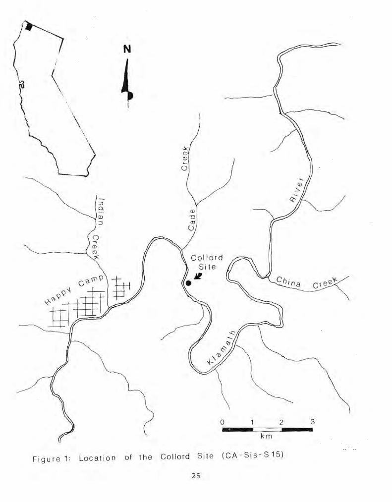
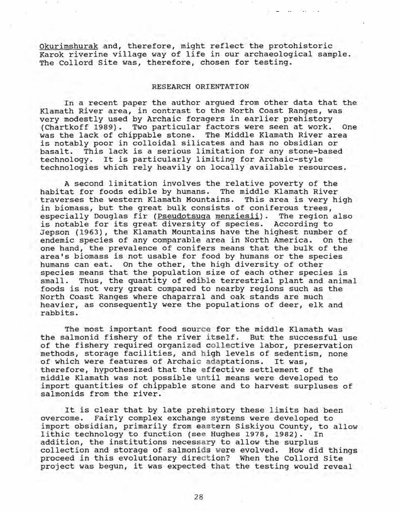
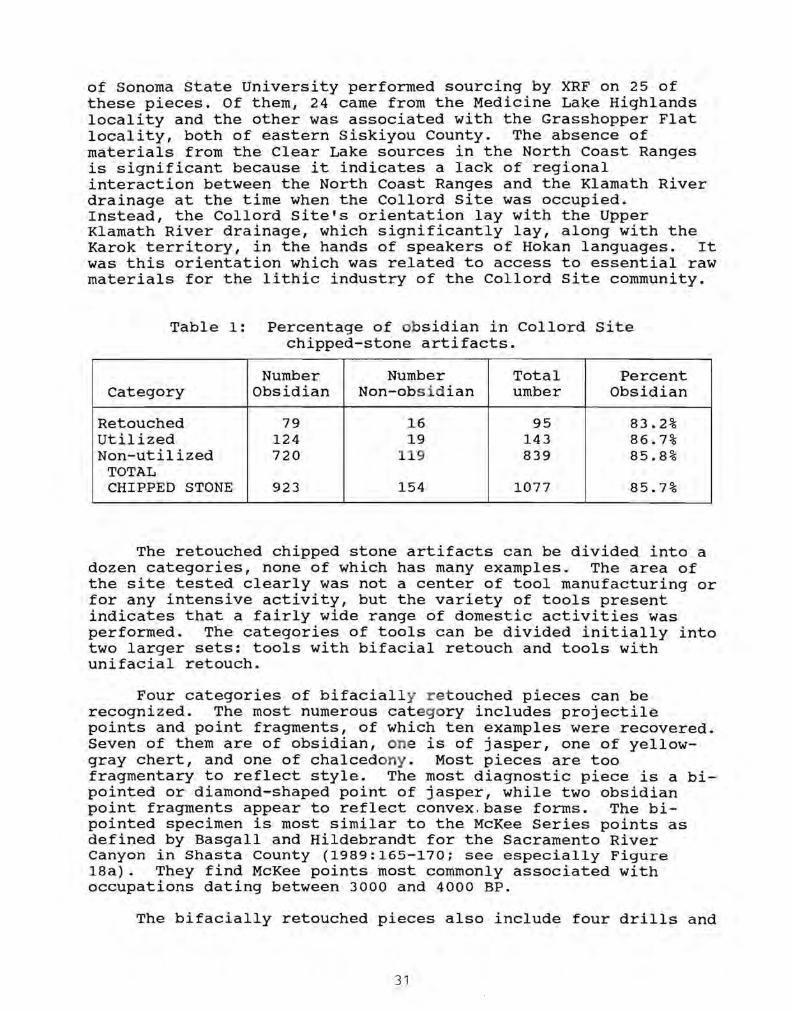