the geoarchaeology of the peace bridge site, fort erie,...
TRANSCRIPT

The Geoarchaeology of the Peace Bridge Site, Fort Erie, Ontario MacDonald, R.I1., S.M. Douglas2, P.F. Karrow3, and A.J. VandenBygaart4
1 Archaeological Services Inc. 2 Ontario Ministry of Natural Resources 3 Department of Earth Sciences, University of Waterloo 4 Agriculture and Agri-Food Canada Abstract: The Peace Bridge site (AfGr-9) is a very large multi-component site situated at the head of the Niagara River in the Town of Fort Erie, Ontario. On-going archaeological investigations have documented occupations from the Late Archaic period (circa 3,580 B.P.) through to the present. Archaeological deposits, sediments, and paleosols exposed through construction activities, bore holes, test pits, and archaeological excavations, reveal the evolution of this riparian landscape and its colonization by Aboriginal peoples. This paper reviews the geoarchaeology of the site and outlines its implications for reconstructing paleoenvironment and interpreting Aboriginal land-use trends.
1
Introduction
SLIDE 1: TITLE SLIDE
SLIDE 2: EXTENT OF PEACE BRIDGE SITE
Since the spring of 1992, Archaeological Services Inc. has been undertaking salvage excavations at
the Peace Bridge site in the Town of Fort Erie. This research has shown that a buried black organic
paleosol, containing evidence of approximately 4,000 years of occupation, encompasses an area of
more than 24 hectares (60 acres) surrounding the approach to the Canadian end of the Peace Bridge.
This paper summarizes geoarchaeological investigations that have been carried out in order to better
understand the paleoenvironmental context and formation processes of the site.
Physiography
SLIDE 3: LOCATION OF PEACE BRIDGE SITE
The Peace Bridge site is situated along the upper reach of the Niagara River where it meets Lake
Erie. This reach is about 600 metres wide, 4 metres deep, and has an average current of about 13
kilometres per hour. Farther downstream, where the river deepens and widens, the flow drops to
around 3 kilometres per hour. North of the Peace Bridge, the constricted river forms a series of
rapids where it flows over the Fort Erie-Buffalo sill, a bedrock ridge which controls the level of
Lake Erie. The valley is bordered by shelved dolostone and limestone pavements and low clay-plain
bluffs. Below the higher bluffs of the Fort Erie moraine, the river has aggraded a floodplain
approximately 400 metres wide. The Peace Bridge site is situated on this floodplain. Across the
river, below the bluffs of the Buffalo moraine, the river has eroded the bank and the floodplain is
much narrower. Although the current riparian environment hardly resembles its pre-settlement

The Geoarchaeology of the Peace Bridge Site,Fort Erie, Ontario
R.I. MacDonald R.I. MacDonald 11, S.M. Douglas , S.M. Douglas 22, P.F. , P.F. KarrowKarrow 33 & A.J. & A.J. VandenBygaartVandenBygaart 44
1 Archaeological Services Inc. 2 Ontario Ministry of Natural Resources 3 Department of Earth Sciences, University of Waterloo 4 Agriculture and Agri-Food Canada


2
condition, nearby Navy Island may represent a remnant of this environmental zone.
Bedrock Geology
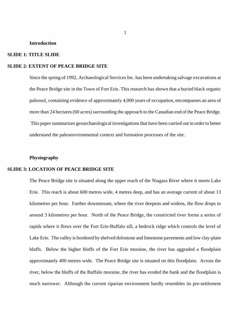
SLIDE 4: NIAGARA BEDROCK CUT-AWAY
The bedrock in the vicinity of the Peace Bridge site consists of dolostone and cherty limestone of
upper Silurian and lower Devonian age that slopes gently towards Lake Erie. In areas to the east and
west of the Niagara River, these form the striking and ecologically significant Onondaga
Escarpment. The chert-rich Clarence Member of the Onondaga Formation outcrops extensively on
most of the north shore of Lake Erie from Fort Erie to Nanticoke (Telford and Tarrant 1975; Parkins
1977:86). Commonly known as Onondaga chert, this material was the most widely used toolstone
throughout regional prehistory. The Clarence Member underlies the Peace Bridge site and is exposed
along the Niagara River waterfront. As the strike of the Onondaga Formation runs roughly east-west
(Buehler and Tesmer 1963), it seems likely that Onondaga chert would also have been available to
prehistoric peoples along the east side of the river, however, land development has modified the
Buffalo waterfront to such an extent that confirmation of this hypothesis is very difficult. Elsewhere
on the New York side of the river, the Onondaga Formation is largely buried by Quaternary deposits
(Cadwell et al. 1986), except along the Onondaga escarpment, where occasional outcrops of chert
may have been available (P. Calkin, J. Holland, personal communications 1997).
Quaternary Geology
SLIDE 5: QUATERNARY GEOLOGY OF FORT ERIE AREA
The bedrock ridge of the Onondaga escarpment, which constitutes the most noteworthy topographic
feature of the southeastern Niagara peninsula, has been subdued by a series of Late Wisconsinan

Peace Bridge Site
Surficial Geology

3
deposits. The most extensive of these is a blanket of glaciolacustrine sediments that was deposited
during the Mackinaw interstadial between 14,000 and 13,000 years ago. Readvance of the Erie lobe
then deposited the complex suite of Halton diamictons during the Port Huron stadial around 13,000
years ago. A brief pause in the following glacial retreat built the Fort Erie moraine, a feature that is
about 6.5 km long, up to 1.5 km wide, and rises about 7 metres above the Onondaga cuesta dipslope.
SLIDE 6: LAKES WAINFLEET & TONAWANDA
As the ice front retreated to the Niagara Escarpment, a series of proglacial lakes inundated the
Niagara Peninsula to the south and laid down deposits of finely laminated clay and silt. When the
ice retreated beyond the Niagara Escarpment around 12,400 B.P., flow via the Niagara River over
the falls began, marking the beginning of early Lake Erie. Residual waters ponded between the
Onondaga and Niagara escarpments formed lakes Tonawanda and Wainfleet on the American and
Canadian sides of the Niagara River, respectively (Calkin and Feenstra 1985:163); Douglas 2003;
Feenstra 1981).
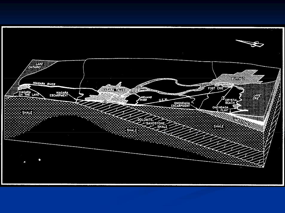
SLIDE 7: LAKE LEVEL CHANGES
The evolution of Lake Erie since its inception is characterized by a complex sequence of fluctuating
levels controlled largely by variations of inflow from the Huron basin, and by changes in the
controlling sills of the Niagara River attributable to the countervailing effects of erosion and isostatic
rebound. Meteorological conditions have also contributed to fluctuations in lake level. Annual
fluctuations historically range about a metre on average, although extreme rises of up to 2.4 metres
have been recorded. From deglaciation until around 10,000 BP, a sill at Fort Erie/Buffalo (~170 m
asl) was in control. During this time, the main highstand of Lake Algonquin (ca. 11,200 - 10,200
B.P.) attained an elevation of 180 m in the Huron basin and likely contributed waters to Lake Erie.


4
Control then switched to the Lyell/Johnson sill (~173 m asl) at Niagara Falls, as isostatic rebound
raised it to, and eventually about 3 metres above, the Fort Erie/Buffalo sill. Water became ponded
again within the Tonawanda/Wainfleet basin at this time, as water levels there approached or
achieved confluence with Lake Erie (Douglas 2003: 181; Pengelly et al. 1997).
SLIDE 8: EXTENT OF PEACE BRIDGE SITE WITH PROFILE & SAMPLING SITES
At the Peace Bridge site, between the waterfront and the base of the Fort Erie moraine scarp to the
west, the river terrace ranges in elevation from about 174 to 178 metres above sea level, while the
brow of the moraine stands at around 183 m asl. This suggests that the terrace was eroded in early
postglacial times and implies generally lower water levels in the Erie basin immediately thereafter
(Calkin and Brett 1978; Tinkler et al. 1992:231-232).
Sedimentation resumed in the vicinity of the Peace Bridge site around 10,000 years ago, as water
levels rose to meet the elevation of the Lyell/Johnson sill.
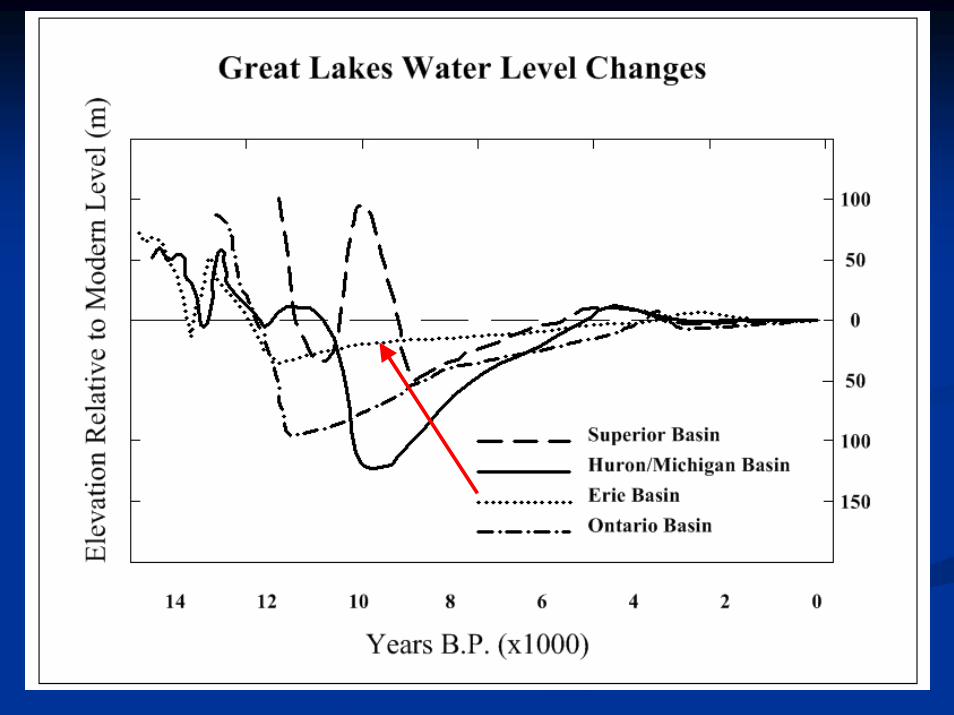
SLIDE 9: BEACH PIT PROFILE
This is confirmed by a radiocarbon date of 9,890 +/- 80 B.P. from the base of a five-metre-deep
sedimentary profile at the Beach Pit profile of the Peace Bridge site (Douglas 2003).
SLIDE 10: BEACH PIT POLLEN SPECTRUM
A pollen spectrum compiled from this profile records a wetland succession from a deep, open-water
wetland to a shallow marsh between 9,890 and 7,500 B.P. This spectrum also records the return to a
deep water marsh environment in an interval consistent with the Nipissing I rise of Great Lakes
water levels between 5,500 and 4,700 B.P. Water levels at the Peace Bridge site dropped again after
the Nipissing I transgression and remained low enough for a shrub-carr wetland community to
develop. This community is indicated by pollen and a woody peat layer in the sedimentary profile,

Beach PitProfile & SamplingSite
Truck PadProfile & SamplingSite
Pier 2 Profile and Sampling Site
Stratigraphy of the Beach Pit, with note of radiocarbon dates.
The colouring of the section approximates that of the sediments.
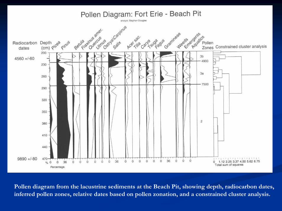
Pollen diagram from the lacustrine sediments at the Beach Pit, showing depth, radiocarbon dates, inferred pollen zones, relative dates based on pollen zonation, and a constrained cluster analysis.
5
which has been radiocarbon dated to 4,560 +/- 60 B.P. Sometime after this date, water levels once
again rose during the Nipissing II transgression, which has been dated elsewhere to between 4,300
and 4,000 B.P. Nipissing II brought water levels up to around 180 metres, thereby inundating the
entire floodplain terrace. Pollen, plant macrofossil, and mollusc assemblages suggest the
development of a deep-water marsh or open-water environment at this time. Nipissing II ended with
the lowering of waters to near modern levels between about 3,800 and 3,900 B.P. This lowering of
water levels seems to have been linked to erosion of the Lyell-Johnson sill at Niagara Falls and the
return of control for Lake Erie levels to the Fort Erie-Buffalo sill. With this change, a gradient was
established between the upper Niagara River and the Fort Erie-Buffalo sill. Depositional conditions
in the upper Niagara River were thus transformed from lacustrine to alluvial for the first time since
before 10,000 B.P.
SLIDE 11: STEPHEN DOUGLAS AT BEACH PIT PROFILE
This transition is reflected in the sedimentary profile at the Peace Bridge site, where lacustrine clay
is overlain by alluvial sands. Although it is possible that the higher, western margins of the
floodplain terrace may have been occasionally exposed earlier, the current terrace seems to have
finally emerged at about this time.
SLIDE 12: TRUCK PAD FEATURES
Supporting evidence for this comes from the earliest clear evidence for human occupation of the
Peace Bridge site, which is attributable to Late Archaic period. Nut shell from two of these Late
Archaic deposits has yielded radiocarbon dates of 3,470 B.P. +/- 60 and 3,580 B.P. +/- 60,
respectively.

Lacustrine/alluvium transition at the Beach Pit. Stephen Douglas points to dark gray lacustrine silty clay that coarsens upward into coarse sand alluvium.

Pre-contact Aboriginalcultural features at Truck Pad Locality,Peace Bridge site.
Carbonized nut shell fromLate Archaic period features has yielded radiocarbon dates of 3,470 B.P. +/- 60 and3,580 B.P. +/- 60.

6
Throughout the last three millennia, water levels in the Erie basin appear to have been largely within
the modern range due to the relative stability of inflow and the controlling sill, although isostatic
rebound continues to gradually lift the north shore. Meteorologically produced lake-level
fluctuations also occur, and several short-term rises have been suggested (Pengelly et al. 1997).
Soils
SLIDE 13: ROB & DEB IN HOLE
The soils of the southeastern Niagara Peninsula are typically dominated by compacted, level, poorly
drained, acidic clays of glacio-lacustrine origin. Better drained loams and clay loams, however, are
associated with the till deposits of the Crystal Beach and Fort Erie Moraines, while coarser, well-
drained soils are associated with glaciolacustrine beach/ off-shore bar deposits and more recent
eolian and wave-deposited sediments of the Lake Erie coast.
At the Peace Bridge site the soil parent material is typically alluvial sand generally over 2 metres
deep. A dark, organic A horizon has developed on this sand as well as a light brown B horizon.
These horizons are often encountered as a buried paleosol overlain with various fill matrices and
asphalt. The topsoil horizon frequently contains large quantities of prehistoric cultural material,
especially lithic debitage. These soils are porous and well drained.
Boreholes suggest some variability in the bedrock topography. Deep excavations near the Peace
Bridge reveal sand overlying a thin, cherty gravel lag resting on bedrock at a depth of less than 2
metres. Excavations and boreholes farther north, however, indicated deeper deposits, with 2 metres


7
of alluvial sand overlying 3 metres of lacustrine clay. Gleying at depths below about 2 metres
demarcates the water table, which roughly corresponds to the elevation of the river (McGlone &
Associates 1993). This suggests that significant rises in the river level would have affected the
drainage properties of these soils through the raising and lowering of the water table.
SLIDE 14: PALEOSOL ANALYSIS - STRUCTURE
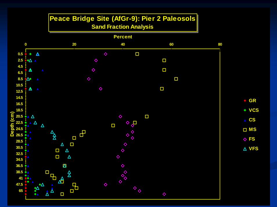
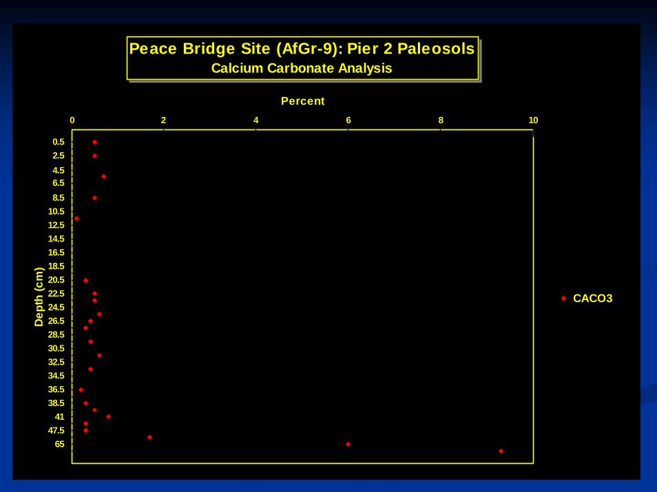
Direct evidence of periodic inundation of the Peace Bridge site has been encountered in the course
of excavations south of the Peace Bridge. At Pier 2, two buried paleosols have been documented,
one directly overlying the other. Analysis of soil structure,
SLIDE 15: PALEOSOL ANALYSIS - PARTICLE SIZE
particle size,
SLIDE 16: PALEOSOL ANALYSIS - SAND FRACTION
sand fraction,
SLIDE 17: PALEOSOL ANALYSIS – pH
pH,
SLIDE 18: PALEOSOL ANALYSIS – PERCENT OF CALCIUM CARBONATE EQUIVALENT
percent of calcium carbonate equivalent,
SLIDE 19: PALEOSOL ANALYSIS - ORGANIC CARBON
and organic carbon indicate that the lower horizon is a Brunisolic paleosol which developed on a
relatively stable surface of silty sand over an extended period. The upper horizon, which has
developed on a somewhat more coarse deposit of sandy alluvium approximately 20 cm thick,
appears to be an immature Regosol. This preliminary classification is based on its less well-
developed stratification and a relatively lower proportion of organic material in its A horizon. The

0 1 2 3 4 5 6
Dep
th (c
m)
1.003.005.007.009.00
11.0013.0015.0017.0019.0021.0023.0025.0027.0029.0031.0033.0035.0037.0039.0042.0050.0070.0090.00
Structure Code
Peace Bridge Site (AfGr-9): Pier 2 PaleosolsSoil Structure Analysis
1=structureless; single grain 2=medium granular 3=medium-coarse subangular blocky4=medium subangular blocky 5=fine-medium subangular blocky 6=fine subangular blocky

0 20 40 60 80 100 120
Dep
th (c
m)
Percent
0.52.54.56.58.5
10.512.514.516.518.520.522.524.526.528.530.532.534.536.538.5
4147.5
65
SAND
SILT
CLAY
Peace Bridge Site (AfGr-9): Pier 2 PaleosolsParticle Size Analysis
0 20 40 60 80
Dep
th (c
m)
Percent
0.52.54.56.58.5
10.512.514.516.518.520.522.524.526.528.530.532.534.536.538.5
4147.5
65
GR
VCS
CS
MS
FS
VFS
Peace Bridge Site (AfGr-9): Pier 2 PaleosolsSand Fraction Analysis

6.6 6.8 7 7.2 7.4
Dept
h (c
m)
pH
0.52.54.56.58.5
10.512.514.516.518.520.522.524.526.528.530.532.534.536.538.5
4147.5
6585
pH (CaCl2)
Peace Bridge Site (AfGr-9): Pier 2 PaleosolspH Analysis
0 2 4 6 8 10
Dep
th (c
m)
Percent
0.52.54.56.58.5
10.512.514.516.518.520.522.524.526.528.530.532.534.536.538.5
4147.5
65
CACO3
Peace Bridge Site (AfGr-9): Pier 2 PaleosolsCalcium Carbonate Analysis

0 0.5 1 1.5 2 2.5
Dept
h (c
m)
Percent of Organic Carbon
0.52.54.56.58.5
10.512.514.516.518.520.522.524.526.528.530.532.534.536.538.5
4147.5
6585
%O.C.
Peace Bridge Site (AfGr-9): Pier 2 PaleosolsOrganic Carbon Analysis
8
presence of Transitional Woodland ceramics in the lower paleosol suggest that this horizon dates
between the end of the Nipissing II rise around 3,800 B.P. and the beginning of the Late Woodland
period around 1,150 B.P. In New York State, deposits similar to the upper paleosol have been
attributed to climatic change associated with events of the Little Ice Age of ca. 450 to 70 B.P.
(Monaghan personal communication 1997). Further analysis will be required to determine the
nature and age of these soils with certainty.
Conclusions
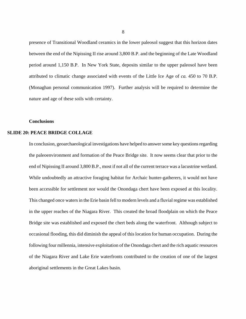
SLIDE 20: PEACE BRIDGE COLLAGE
In conclusion, geoarchaeological investigations have helped to answer some key questions regarding
the paleoenvironment and formation of the Peace Bridge site. It now seems clear that prior to the
end of Nipissing II around 3,800 B.P., most if not all of the current terrace was a lacustrine wetland.
While undoubtedly an attractive foraging habitat for Archaic hunter-gatherers, it would not have
been accessible for settlement nor would the Onondaga chert have been exposed at this locality.
This changed once waters in the Erie basin fell to modern levels and a fluvial regime was established
in the upper reaches of the Niagara River. This created the broad floodplain on which the Peace
Bridge site was established and exposed the chert beds along the waterfront. Although subject to
occasional flooding, this did diminish the appeal of this location for human occupation. During the
following four millennia, intensive exploitation of the Onondaga chert and the rich aquatic resources
of the Niagara River and Lake Erie waterfronts contributed to the creation of one of the largest
aboriginal settlements in the Great Lakes basin.
