the geology of the cantabrian belt in the area surrounding ... · pdf file3 abstract the pico...
TRANSCRIPT
The Geology of the Cantabrian Belt in the area surrounding Pico Jano, Leon, Espãna
Thomas William Dale
A report submitted in partial fulfilment of the requirements for the degree of e.g., B.Sc
Geology, University of Manchester
School of Earth, Atmospheric and Environmental Sciences, The University of Manchester,
Oxford Road, Manchester, M13 9PL
February, 2013
2
3
Abstract
The Pico Jano area is a sub-division of the Elsa Nappe region located in the Cantabrian Mountains,
North Spain. The area is predominantly composed of a Cambrian-Carboniferous succession of
unmetamorphosed sedimentary rocks deposited in a shallow marine environment. Much of the
exposed stratigraphy belongs to a series of prominent weather resistant limestones belonging to
the Devonian-Carboniferous eras. Prior to this sediments were primarily classified as terrigenous
clastic with exception to the Lancara limestone formation. This onset of a carbonate dominated
deposition in the latter half of the Cambrian-Carboniferous succession is due a profound change
in the method of carbonate deposition, Cambrian carbonates were built as archaeocyatha
shelves which switched to a more productive coral shelf based carbonate deposition in the mid-
Palaeozoic.
The structure of the Pico Jano area owes much of its present day nature to the Variscan Orogeny
of the Late Carboniferous period, during which a series of thrust sheets caused crustal thickening
defining the Esla Nappe region and more specifically its Pico Jano segment. The Pico Jano
segment itself is composed of two nappes; the Corniero Nappe and the Esla Nappe. The two
thrust sheets are separated by a minor thrust sheet, the fore ramp of which is called the Pico Jano
Duplex. Originally originating in the same succession as the Corniero Nappe, the Pico Jano Duplex
was thrust prior to the emplacement of the Corniero Nappe undercutting it and deforming the
fore-ramp of the already emplaced Esla Nappe. Activity in the broader Cantabrian zone has
caused further deformation in the Pico Jano area since the activating of the Esla and Corniero
Nappes resulting in less significant folding and faulting regarding the magnitude of deformation.
The Alpine Orogeny during the Stephanian B era caused isostatic lift across the whole Cantabrian
Zone. Consequently rates of erosion increased leading to the formation of poorly sorted syn-
orogenic conglomerates across the south east of the Pico Jano area
4
Table of Contents
1.0. Introduction
1.1. Regional Geological Setting
1.2. Summary of the geology of the mapped area
2.0. Stratigraphy
2.1. Lancara Formation ………………………………………..
2.2. Oville Formation ……………………………………………
2.3. Barrios Formation ………………………………………...
2.4. Formigoso Formation ……………………………………
2.5. San Pedro Formation …………………………………….
2.6. La Vid Formation …………………………………………..
2.7. Santa Lucia Formation ………………………………….
2.8. Huergas Formation ……………………………………….
2.9. Portilla Formation …………………………………………
2.10. Alba Formation……………………………………………
2.11. Caliza de Montana Formation …………………….
2.12. Bonar Formation ……………………………………….
3.0. Structure
4.0. Geomorphology
5.0. Economic geology
6.0. Geological history
7.0. Acknowledgements
8.0. References
8.1. Literature
8.2. Software
5
8
9
9
9
10
11
12
13
14
15
18
19
21
22
22
24
27
28
29
33
34
34
35
5
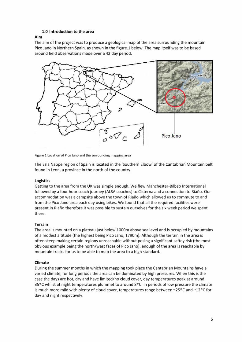
1.0 Introduction to the area Aim The aim of the project was to produce a geological map of the area surrounding the mountain Pico Jano in Northern Spain, as shown in the figure.1 below. The map itself was to be based around field observations made over a 42 day period.
Figure 1 Location of Pico Jano and the surrounding mapping area
The Esla Nappe region of Spain is located in the ‘Southern Elbow’ of the Cantabrian Mountain belt found in Leon, a province in the north of the country. Logistics Getting to the area from the UK was simple enough. We flew Manchester-Bilbao International followed by a four hour coach journey (ALSA coaches) to Cisterna and a connection to Riaño. Our accommodation was a campsite above the town of Riaño which allowed us to commute to and from the Pico Jano area each day using bikes. We found that all the required facilities were present in Riaño therefore it was possible to sustain ourselves for the six week period we spent there. Terrain The area is mounted on a plateau just below 1000m above sea level and is occupied by mountains of a modest altitude (the highest being Pico Jano, 1790m). Although the terrain in the area is often steep making certain regions unreachable without posing a significant saftey risk (the most obvious example being the north/west faces of Pico Jano), enough of the area is reachable by mountain tracks for us to be able to map the area to a high standard. Climate During the summer months in which the mapping took place the Cantabrian Mountains have a varied climate, for long periods the area can be dominated by high pressures. When this is the case the days are hot, dry and have limited/no cloud cover, day temperatures peak at around 35®C whilst at night temperatures plummet to around 8®C. In periods of low pressure the climate is much more mild with plenty of cloud cover, temperatures range between ~25®C and ~12®C for day and night respectively.

6
Land Use Due to the steep relief of the area any grassland on the slopes is used for pastoral farming, mainly in the form of goat herding. Woodland and forest is sparse in the area with the only real woodland located on the north face of Pico Jano and on the slopes directly north of Las Salas. Other more minor land uses included settlements and quarrying. Exposure In most areas exposure was good, especially exposure of the more weather resistant formations such as the limestones, quartzites and consolidated sandstones. Physical features such as the Pico Jano duplex provided large limestone cliff faces on all sides of the mountain with ample exposure allowing thorough and detailed analysis of the composition and its structure. Large areas of exposure such as the Pico Jano duplex creates the possibility of producing detailed stratigraphic logs of the formations and therefore allowing us a greater insight into the evolution of the lithology’s depositional environment. Artificial features which provide an improved view of the stratigraphy is limited to quarries and road side excavations. Useful literature A number of papers have been published on the Esla Nappe area, the most useful of which are: WALLACE, P. 1972. The Geology of the Palaeozoic Rocks of the South-Western Part of the Cantabrian Cordillera, North Spain. Proceedings of the Geologists' Association .Vol 83, 1, 57–73. Alonso, J. 1987. Sequences of thrusts and displacement transfer in the superposed duplexes of the Esla Nappe region (Cantabrian Zone, NW Spain). Journal of Structural Geology, Vol.9(8), pp.969-983 Álvaro, J.J ; Vennin, E ; Moreno-Eiris, E ; Perejón, A ; Bechstädt, T. 2000. Sedimentary patterns across the Lower-Middle Cambrian transition in the Esla Nappe. These provide information on the lithology, structure and carbonates respectively. Sedimentary Geology, 2000, Vol.137(1), pp.43-61 These provide information on lithology, structure and important changes in carbonates deposition respectively.

7
1.1. Geological Setting
The Cantabrian Mountains are an E-W trending range located in Northern Spain. The Cantabrian
Zone is located in the foreland of the Variscan Belt (Gasparrini et al, 2006), and is one of many
areas located across North America and Western/Central Europe which once comprised part of
the southern coast of Laurasia. It is also an area which experienced orogeny in the Late Palaeozoic
due to a collision between the continental plates Laurasia and Gondwana. The Variscan tectonics
became active in the Late Carboniferous (Gasparrini et al, 2006) with the emplacement of
regional thrusts and folds followed by later fracturing. From Late Pre-Cambrian times until the
end of the Palaeozoic, the region was located in a shallow shelf sea, in which deposition was in
the form of limestone (often highly fossiliferous), shale and shallow-water sandstones (Wallace,
1972). The deposition of this succession coincided with a major change in carbonate production,
prior to the Lower-Middle Cambrian transition subtropical carbonates sediments were composed
of primarily ooidal shoals, cyanthan and microbial build up, and a peritidal deposits (Álvaro,
2000). After this transition carbonate production became largely dependent on archaeocyathan
reefs (Álvaro, 2000), a transition that can be observed in the Láncara limestone formation (Álvaro,
2000). The Late Pre-Cambrian – Palaeozoic succession is relatively thin and possesses many
unconformities although these are more concentrated in the Lower Palaeozoic period in
comparison to the Later Palaeozoic period (Wallace, 1972). As a result of this change in carbonate
production the proportion of limestone deposition increases during the Late Palaeozoic resulting
in prolific formations such as Santa Lucia, La Vid and Portilla (Devonian shelf limestone) and Caliza
de Montaña (Carboniferous mud mound limestone) (Wallace, 1972). Deposition effectively
ceased during the Variscan orogeny, which deformed the rock so that many of the rocks were
vertical or totally overturned (Wallace, 1972). The orogeny didn’t induce metamorphism. Post
Orogenic-activity conglomerates and coarse sandstones filled the basins of the Late
Carboniferous unconformably overlaying the Pre-Cambrian – Palaeozoic succession, whilst plant
Section from: Alvaro 2000
Sedimentary patterns across the
Lower-Middle Cambrian transition
in the Esla Nappe. Sedimentary
Geology 137, 43-61.
Figure 2. Simplified geological
overview of the Cantabrian Zone
showing the location of the study
area.

8
debris accumulated to form coal seams (Wallace, 1972).
1.2. Summary of the mapped area
The Pico Jano area is composed of a relatively simple sedimentary succession spanning from the
mid-Cambrian to the mid-Carboniferous period. The stratigraphy is composed of sediments which
are initially dominated by clastic formations but after the early Devonian are carbonate
dominated. Although lithologically simple the area has a complex structural setup. The Variscan
Orogeny of the late Carboniferous and subsequent less significant orogenic events has caused
regional deformation of the entire Cantabrian Zone in the form of large scale thrust sheets and
faulting as well as more minor folds and normal/strike-slip faulting. The Pico Jano area is densely
packed with such features all across the size spectrum. It features three thrust sheets (two of
which are nappes), a duplex and countless medium-small scale faults and folds. Most deformation
in the area appears to be trending in or perpendicular to the NW-SE plane. In the south east
regions of the area the stratigraphy and its structure have been overlain by Cretaceous
conglomerates.
9
2.0. Stratigraphy of the Pico Jano area
The stratigraphic column provided should be used with the following section to aid understanding
f deposition sequence and nature of contacts between formations.
2.1. Láncara
The Láncara formation a multi-membered limestone recognisable by its upper red griotte
member as well as its prominent grey basal member. Láncara forms the base of the Esla Nappe
as any stratigraphy below it has been faulted out and replaced by the Caliza de Montaña of the
Pico Jano Duplex. The Láncara formation has been estimated to be between 50-100m in thickess
in this area, however as no complete formation was present the true thickness of the formation is
likely to be significantly higher than this estimation. The upper limit of the formation is defined by
an inferred contact as a lithological change between the Láncara and the Oville is unexposed but
assumed to be planar and abrupt. The formation’s exposure throughout the area was very
limited, present only upon the Esla Nappe occupying the area between localities 0326197
4753691 and 0327734 4753468 east of Crémenes. The Láncara takes its name from the town
Láncara de Luna (Wallace, 1972) with each of its formations named based on their appearances,
Láncara Limestone and Láncara Griotte. The formation is ~middle Cambrian(Wallace, 1972)
suggested due to the presence of brachiopods from that era.
As the definitive base of the Láncara cannot be determined due to a break in stratigraphy it can
only be assumed that the formation contains two members, although there is potential for more.
Previous literature on the region describes the Láncara as a three member formation, which
includes the addition of a basal ooilithic dolomites containing local algal stromtalites (Wallace,
1972) not present in Pico Jano Duplex area mapped by ourselves. The two members, the lower
Láncara Limestone and the upper Láncara Griotte, only occur once within the stratigraphic
sequence.
The Láncara Limestone member is a fine grained and calcite rich limestone with a battleship grey
coloured matrix. The limestone matrix contains matt black minerals in abundance. Bedding layers
throughout this member vary between 10-20cm thick. Add about the thin sections.
The grey limestone member shares a planar and abrupt contact with the younger Láncara Griotte
member. A coarse grained burgundy limestone, very calcite rich (much more so than the previous
member). Bed thickness reduces rapidly in thicknesses (in the space of 20m) as the member gets
younger, beds reduce to size from 10-20cm to beds of ~3cm (as shown in the sketch below). Thin
beds are very fine grained, less calcitic than thicker beds and take a nodular nature. The Láncara
Griottes association with intertidal algal deposits suggests that it was deposited in a shallow
marine intertidal environment (Wallace, 1972). The Láncara in the Pico Jano area appears to have
been deposited in water of moderate depth as it is coral free.

10
Figure 3. Láncara upper/lower member contact found at
2.2. Oville
Prodominantly a shale formation, the Oville has only one member. The Oville formation's most
prominant feature is the largely an orange colour exhibited by weathered surfaces in shale and
sand beds alike. The formation is estimated to be approximately 830m thick in this part of the
Esla Region. After its clean contact with the Láncara the formation begins as a predominantly
shale outcrop and as the formation gets younger, gradually the sandstone interbeds become
more frequent until eventually the formation is composed of mainly sandstone. The formation is
exposed throughout large areas across the map including exposure on both the Elsa Nappe and
the Corneiro Nappe. Outcrop was only really limited to area heavily exposed to erosion, i.e. ridges
and localities of artificial erosion, e.g. during road building. The Oville type locality is a village east
of the mapped area in which the formation is exposed. The Oville formation originates again from
the Middle Cambrian, derived from the Middle Cambrian trilobite fauna present in the basal
shales (Wallace, 1972).
The base of the Oville is composed of mostly large mudstone bands with infrequent beds of
sandstone in between. The mudstone is found in very poorly consolidated beds ~3cm in thickness
and as a result heavily jointed and often displaying deformation. The matrix contains traces of an
orange mineral believed to be glauconite, approximately 20%. The infrequent sandstone bands
are fine graded and appear to be more glauconite rich. Although more resistant than the shale,
the beds are ~ 15cm and remain poorly consolidated and jointed.
As the formation progresses the sandstone beds become more frequent, more consolidated and
increase in grain size, feldspar and quartz have become recognisable and more glauconite rich,
now at ~60% glauconite. Sandstone beds have begun to display grey laminations parallel to the
bedding. Basal sandstone beds often contain load cast bed forms. The Oville displayed ripple
structures upon occasional sand beds whilst commonly displaying slump structures at the sand
bed base however, all occurrences were too unconvincing for a definitive identification as the
unconsolidated sand appeared too weathered to rule out the structures being a result of erosion.
According to Wallace (1972) the base of the Oville contains well preserved trilobite fauna
however, none were observed in the mapping area.
The consistency of the Oville Formation suggests that it was deposited in an environment which
remained stable with localised ripple structures suggesting that it was shallow marine. The size of
the formation suggests that sedimentation was quick, whilst an increase in sand as the formation
gets older suggests the sediment reworking took place in the shallow basin (Wallace, 1972).

11
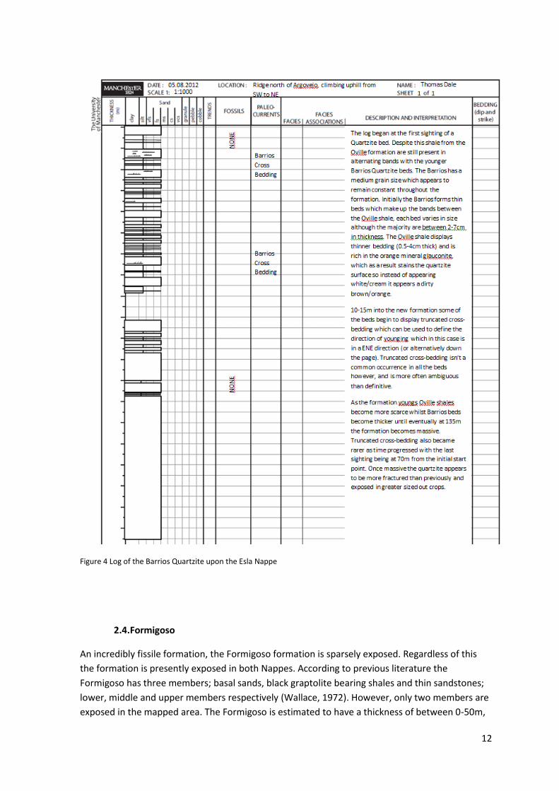
2.3. Barrios Quartzite
The Barrios Quartzite is very prominent single member formation, present across both nappes it
is the only metamorphic formation of the region’s Cambrian – Carboniferous succession. The
Barrios Quartzite formation has a thickness between 75-280m. The formation emerges from the
Oville across a gradational contact composed of alternating mud beds of the Oville and quartzite
beds of the Barrios. Due to the formation having an incredibly high resistance to weathering, the
Barrios is often exposed along well defined ridges isolated from surrounding formations. This is
especially the case in the north eastern area of the map. The Barrios Quartzite was deposited
during the Ordovican period from the late Potsdamian to the end of the Arenig era (Wallace,
1972).
The Oville and Barrios Quartzite share a gradational planar contact in which the quartzite first
emerges thinly bedded (~5cm) and medium grained, alternating with mudstone of the Oville
formation. The thin quartzite beds display an orange tint which maybe to be due staining as a
result of the presence of glauconite in the Oville’s shale beds. As the formation moves upwards
the shale beds become less frequent whilst the Barrios Quartzite bedding becomes increasingly
thicker. This coincides with the glauconite presence decreasing, consequently the rock changed to
a white/creamy colour. Whilst still thinly bedded that the quartzite displays regular cross bedding
(of crest height ~35mm and wave length ~40mm) as seen at 0327617 4753008. Eventually 120m
into the formation the Barrios Quartzite becomes massive. The massive quartzite is heavily
jointed throughout, remains medium grained and of the same composition as the pure
white/creamy bedded quartzite previously lower down the formation. A log across the Barrios
Quartzite (see below fig.4) shows the nature of the gradational boundary and the Quartzites
transition from bedded to massive. In the initial 80m of the formation the alternating bands
remain quite constant in size (no increasing/decreasing trends apparent) with the only difference
being an increase in Barrios Quartzite bed size as the formation gets younger, suggesting
deposition events increased in magnitude during quartzite deposition. As the protolith to the
Barrios Quartzite is a sandstone, the alternating formations are indicative of an environment
frequently alternating between mudflats and tidal flats.
The Barrios Quartzite has an absence of fossils and trace fossils throughout.
The base of the formation, alternating muds and quartzite beds suggest that the Barrios began in
a shallow marine environment, a theory backed up by the truncated cross bedding found in the
thin quartzite beds. As the formation continues the deposition environment stabilises as a tidal
flat. Once the Barrios Quartzite displays massive bedding this signifies the start of a continuous
supply of sediment.
12
Figure 4 Log of the Barrios Quartzite upon the Esla Nappe
2.4.Formigoso
An incredibly fissile formation, the Formigoso formation is sparsely exposed. Regardless of this
the formation is presently exposed in both Nappes. According to previous literature the
Formigoso has three members; basal sands, black graptolite bearing shales and thin sandstones;
lower, middle and upper members respectively (Wallace, 1972). However, only two members are
exposed in the mapped area. The Formigoso is estimated to have a thickness of between 0-50m,

13
the upper limit of this estimate is somewhat undermined by the non-observation of the lower
member described by Wallace (1972) and Comte (1959). The Formigoso begins after a parallel yet
unconformable contact between itself and the Barrios Quartzite. In all cases the Formigoso is
poorly exposed at the bases of steep slopes, a direct result of the difference in the resistance to
weathering between the Barrios Quartzite and itself. The presence of graptolites in the middle
member insinuates that the formation dates from the Upper Llandovery and Ludlow era (Comte,
1959).
The middle member of the Formigoso is a dark brown/black incredibly fissile shale, very thinly
bedded approximately ~3cm thick. The member is being graptolite bearing however, the
graptolotes are not present in all three areas of Formigoso exposure. When found however, the
fossils are very well preserved suggesting a very low energy deposition environment with low
levels of oxygen, possibly a sheltered basin with a physical silt barrier preventing oxygen
dissolving into the liquid.
Moving into the upper thin sandstone member across an abrupt planar contact, the formation
becomes a well sorted fine grained structure, pale olive green in colour. The sand contains white
mica and biotite although the proportions vary between beds as some are rich in the micas (>
40%) whilst others are clearly not (<20%). Observable exposure shows that this member is only
approximately 20m in height. Wallace has described this member as containing trails burrows and
load clasts however, once again they appear to be absent in the limited exposure found in the
mapping area.
The deposition environment of the Formigoso Shale must have been very calm and shallow due
to the lack of sedimentary structure displayed by mud exposure. However, the presence of
Graptolites provides evidence that the environment was not stagnent (Wallace, 1972).
2.5. San Pedro
San Pedro is overall a well consolidated, medium grained sandstone exposed across both nappes
and can be divided into three individual members. The San Pedro as a formation is 50-200m in
hieght. The basal member should follow an abrupt, planar contact between itself and the
Formigoso formation, however, in parts of the area the Formigoso is assumed to have thinned
out (at 0328715 4753663) as it has been observed that the San Pedro and the Barrios Quartzite
can share a parallel yet unconformable contact with no evidence of faulting. The San Pedro takes
its name from the town located ~50km south of Argovejo. According to Comte (1959), the
formation is thought to span the Silurian-Devonian boundary, dating from Upper Wenlock at the
basal member to Lower Gedinnian at the upper member contact with La Vid.
The Basal member is composed of reasonably well sorted, thickly bedded sandstones (40-60cm)
of a dusty yellow colour. Fresh faces reveal this member to be a medium grained rock less well
consolidated than the previous Barrios Quartzite formation but relatively resistant to weathering.
Beds display no internal structures with grains appearing to be in random orientations. Basal beds
display symmetrical dunes (~6cm in crest height), however, other such features and structures
such as fossils, ripples and slumping appear to be absent. The dunes insinuate a shallow marine
intertidal deposition environment whilst the moderately well sorted matrix opens up the
possibility that the sand was reworked by fluvial processes in an environment such as a delta.

14
The thick basal sandstone moves abruptly into the middle shale member. The majority of
exposure displays large bands of dull grey/brown shale with infrequent beds of fine grained sands
of a dull grey/sandy yellow. The band heights being >1m and <20cm respectively. Shales appear
to be fissile, heavily jointed, unfossiliferous and often heavily deformed exhibiting almost perfect
compression sequences.
Finally the upper member of the San Pedro emerges as a well sorted quartz rich sandstones
interbedded with fissile brown/black shale. The quartz rich sandstone appears to be fine grained,
with the majority of beds being jointed and heavily laminated, approximately 1mm in size. The
shale is again fissile and unfossiliferous.
The entire San Pedro formation is iron rich, suggesting an abundance of organic matter present in
its deposition environment. The Basal San Pedro Member suggests a shallow, moderately
energetic environment, whilst thick bedding planes indicates a rapid deposition rate. As the
formation gets younger the finer grain size suggests that the deposition environment possesses a
lower energy than before. The middle member is probably situated in deeper waters causing the
magnitude of tidal influence to decrease. The Upper San Pedro displays an increased grain size
suggesting relative sea levels have fallen to provide an increase in the environment energy.
Obvious laminations suggest short deposition events and a return to a river delta environment.
The well sorted nature of the member offers the idea that the sediment was reworked by fluvial
channels to a greater extent than in the lower San Pedro.
2.6. La Vid
The La Vid limestone is an often well exposed dark grey, highly fossilferous limestone
recognisable due to its red dolomitic basal member. The formation can be divided into three
members; the lower member being the basal red dolomites, the middle member being a grey
limestone followed by an upper member rich in crinoids stems. The middle La Vid member
experiences large variations in fossil concentration as their distribution appears to be in large lens
like structures (Wallace, 1972). La Vid has an estimated thickness of 630-830m, this value may
have been enhanced by a series of folds which have caused N-S shortening of the formation in
the only location in which the full formation is observed. La Vid is introduced via an abrupt planar
contact between itself and the underlying San Pedro Formation. Consistently well exposed across
both nappes, it displays highly varying characteristics within the middle member. Lower member
brachiopods in the Basal member provide evidence that suggesting the formation formed during
the Gedinnian to Siegenian age, early Devonian (Comte, 1959).
The Basal member of the La Vid is comprised of a vibrant red dolomitic limestone. The dolomite itself is coarse grained containing abundant vugs, some of which have been infilled as minerals have recrystallised inside, although the majority appear to hollow. All bedding structure has been destroyed by the process of dolomitisation giving the member a massive yet heavily fractured appearance. Brachiopod, crinoid stems, rhynchonellids and stromatolites are all well preserved extruded from the rock as silicified fossils. The Basal member is approximately 20m in height.
The middle member of La Vid begins after an abrupt planar contact. It is a moderately bedded dark grey limestone, approximately 15-30cm. The matrix is very fine grained and calcite rich. Often exposure is covered in calcareous deposits giving it a massive appearance. The middle member is highly fossiliferous, fossils have been deposited in lense shaped distribution patterns and therefore the fossil content varies across the area. Rock within the fossiliferous lenses

15
contain: brachiopods, crinoids stems, corals and rhynchonellids; on average 80%, 10%, 5% and 5% respectively with burrows also a common occurence. Although in rock found outside these lenses only the prior two fossils are found and are much less frequent.
The upper member is a light grey limestone, fine grained with bedding sizes much the same as the previous member. The fossil content of has changed dramatically from a brachiopod dominated composition found in lenses to a totally crinoids dominated composition, which as we move up the member rapidly becomes increasingly concentrated with the rock making the transition from a wackestone to a packstone. The distribution in this member is consistent throughout the mapping area. The beds at the very top of this member and the formation originate as lithified depth accumulations as the rock is almost entirely made up of crinoid stems, fragments of brachiopods and rhynchonellids are also present. The upper member of La Vid is estimated to be approximately 20m in thickness.
The La Vid formation is largely coral deficient and therefore marine depth is assumed to have been too great to support a coral reef. Instead an abundance of crinoids and brachiopods seems to suggest moderate depth with low clastic input. The formation must shallow towards the middle member as corals have been found within the fossiliferous lenses however, the limestone is still crinoid dominated. In the upper member of La Vid the limestone becomes a lithified depth accumulation of mainly corals and crinoid stems.
Figure 5. Packstone sample from the upper La Vid found in the Esla Nappe stratigraphy
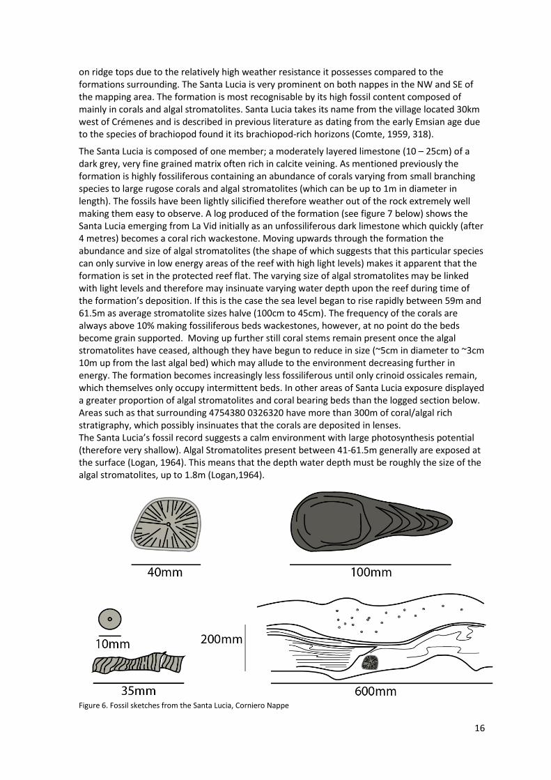
2.7. Santa Lucia
The Santa Lucia is one of the area’s more prolific and recognisable limestone formations. It is a single member formation which is between 100-275m thick. The formation shares a clean and planar contact with the underlying La Vid formation. The prolific limestone is often found exposed
Bryozoa
Rhynchonellids
Crinoids
Brachiopod Fragments
16
on ridge tops due to the relatively high weather resistance it possesses compared to the formations surrounding. The Santa Lucia is very prominent on both nappes in the NW and SE of the mapping area. The formation is most recognisable by its high fossil content composed of mainly in corals and algal stromatolites. Santa Lucia takes its name from the village located 30km west of Crémenes and is described in previous literature as dating from the early Emsian age due to the species of brachiopod found it its brachiopod-rich horizons (Comte, 1959, 318).
The Santa Lucia is composed of one member; a moderately layered limestone (10 – 25cm) of a dark grey, very fine grained matrix often rich in calcite veining. As mentioned previously the formation is highly fossiliferous containing an abundance of corals varying from small branching species to large rugose corals and algal stromatolites (which can be up to 1m in diameter in length). The fossils have been lightly silicified therefore weather out of the rock extremely well making them easy to observe. A log produced of the formation (see figure 7 below) shows the Santa Lucia emerging from La Vid initially as an unfossiliferous dark limestone which quickly (after 4 metres) becomes a coral rich wackestone. Moving upwards through the formation the abundance and size of algal stromatolites (the shape of which suggests that this particular species can only survive in low energy areas of the reef with high light levels) makes it apparent that the formation is set in the protected reef flat. The varying size of algal stromatolites may be linked with light levels and therefore may insinuate varying water depth upon the reef during time of the formation’s deposition. If this is the case the sea level began to rise rapidly between 59m and 61.5m as average stromatolite sizes halve (100cm to 45cm). The frequency of the corals are always above 10% making fossiliferous beds wackestones, however, at no point do the beds become grain supported. Moving up further still coral stems remain present once the algal stromatolites have ceased, although they have begun to reduce in size (~5cm in diameter to ~3cm 10m up from the last algal bed) which may allude to the environment decreasing further in energy. The formation becomes increasingly less fossiliferous until only crinoid ossicales remain, which themselves only occupy intermittent beds. In other areas of Santa Lucia exposure displayed a greater proportion of algal stromatolites and coral bearing beds than the logged section below. Areas such as that surrounding 4754380 0326320 have more than 300m of coral/algal rich stratigraphy, which possibly insinuates that the corals are deposited in lenses. The Santa Lucia’s fossil record suggests a calm environment with large photosynthesis potential (therefore very shallow). Algal Stromatolites present between 41-61.5m generally are exposed at the surface (Logan, 1964). This means that the depth water depth must be roughly the size of the algal stromatolites, up to 1.8m (Logan,1964).
Figure 6. Fossil sketches from the Santa Lucia, Corniero Nappe

17
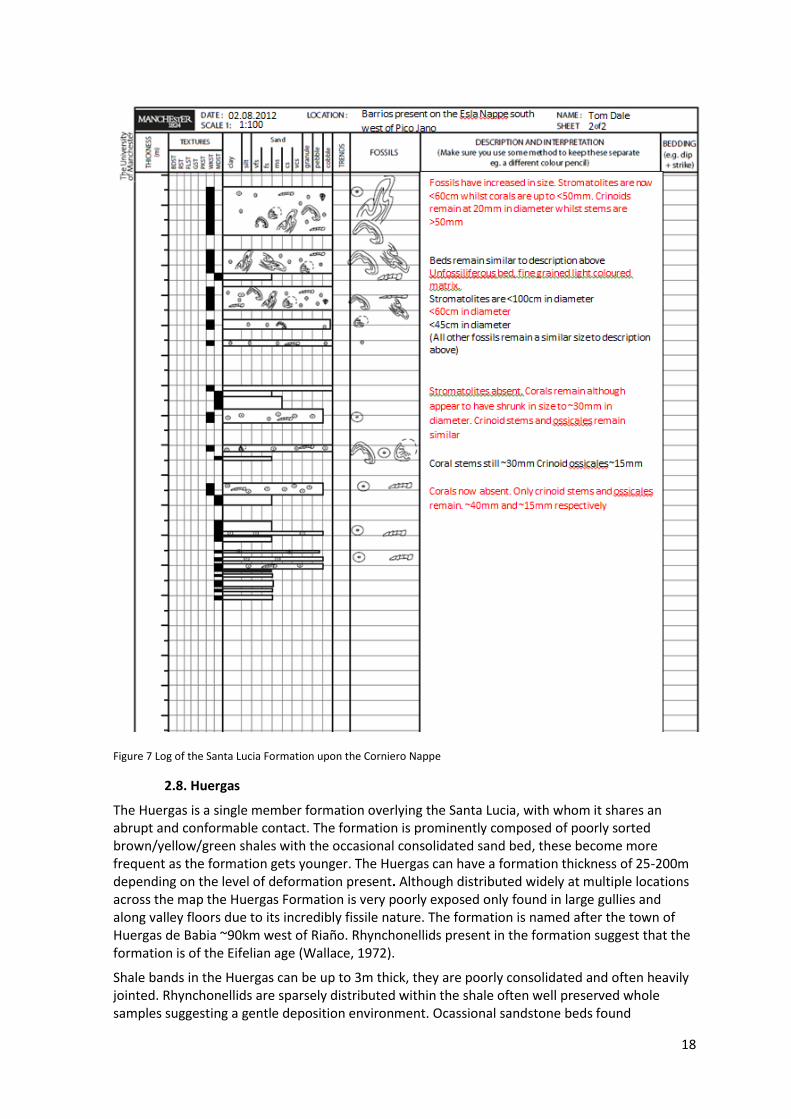
18
Figure 7 Log of the Santa Lucia Formation upon the Corniero Nappe
2.8. Huergas
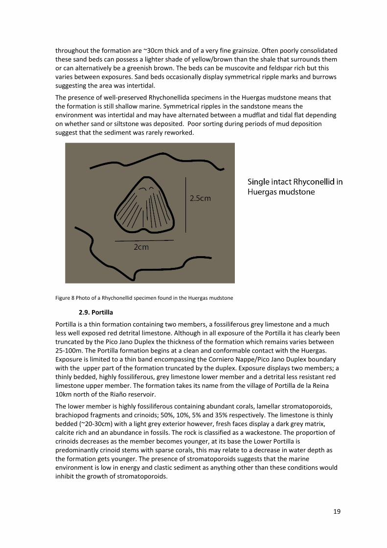
The Huergas is a single member formation overlying the Santa Lucia, with whom it shares an abrupt and conformable contact. The formation is prominently composed of poorly sorted brown/yellow/green shales with the occasional consolidated sand bed, these become more frequent as the formation gets younger. The Huergas can have a formation thickness of 25-200m depending on the level of deformation present. Although distributed widely at multiple locations across the map the Huergas Formation is very poorly exposed only found in large gullies and along valley floors due to its incredibly fissile nature. The formation is named after the town of Huergas de Babia ~90km west of Riaño. Rhynchonellids present in the formation suggest that the formation is of the Eifelian age (Wallace, 1972).
Shale bands in the Huergas can be up to 3m thick, they are poorly consolidated and often heavily jointed. Rhynchonellids are sparsely distributed within the shale often well preserved whole samples suggesting a gentle deposition environment. Ocassional sandstone beds found
19
throughout the formation are ~30cm thick and of a very fine grainsize. Often poorly consolidated these sand beds can possess a lighter shade of yellow/brown than the shale that surrounds them or can alternatively be a greenish brown. The beds can be muscovite and feldspar rich but this varies between exposures. Sand beds occasionally display symmetrical ripple marks and burrows suggesting the area was intertidal.
The presence of well-preserved Rhychonellida specimens in the Huergas mudstone means that the formation is still shallow marine. Symmetrical ripples in the sandstone means the environment was intertidal and may have alternated between a mudflat and tidal flat depending on whether sand or siltstone was deposited. Poor sorting during periods of mud deposition suggest that the sediment was rarely reworked.
Figure 8 Photo of a Rhychonellid specimen found in the Huergas mudstone
2.9. Portilla
Portilla is a thin formation containing two members, a fossiliferous grey limestone and a much less well exposed red detrital limestone. Although in all exposure of the Portilla it has clearly been truncated by the Pico Jano Duplex the thickness of the formation which remains varies between 25-100m. The Portilla formation begins at a clean and conformable contact with the Huergas. Exposure is limited to a thin band encompassing the Corniero Nappe/Pico Jano Duplex boundary with the upper part of the formation truncated by the duplex. Exposure displays two members; a thinly bedded, highly fossiliferous, grey limestone lower member and a detrital less resistant red limestone upper member. The formation takes its name from the village of Portilla de la Reina 10km north of the Riaño reservoir.
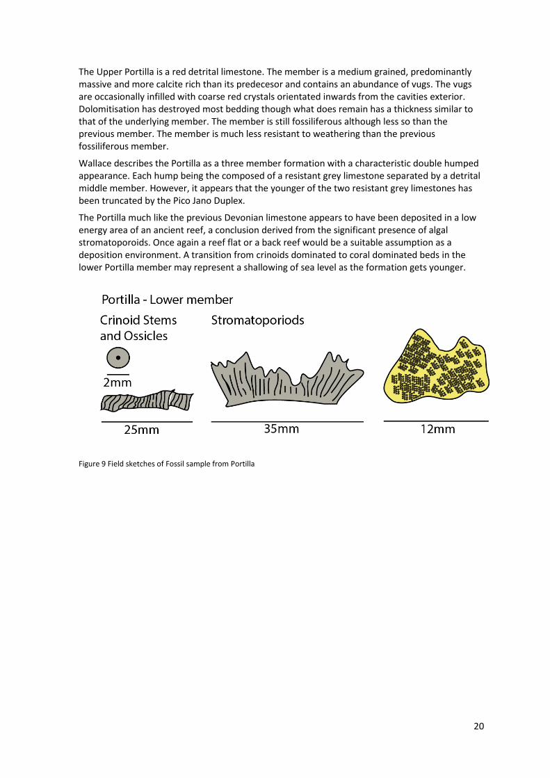
The lower member is highly fossiliferous containing abundant corals, lamellar stromatoporoids, brachiopod fragments and crinoids; 50%, 10%, 5% and 35% respectively. The limestone is thinly bedded (~20-30cm) with a light grey exterior however, fresh faces display a dark grey matrix, calcite rich and an abundance in fossils. The rock is classified as a wackestone. The proportion of crinoids decreases as the member becomes younger, at its base the Lower Portilla is predominantly crinoid stems with sparse corals, this may relate to a decrease in water depth as the formation gets younger. The presence of stromatoporoids suggests that the marine environment is low in energy and clastic sediment as anything other than these conditions would inhibit the growth of stromatoporoids.
20
The Upper Portilla is a red detrital limestone. The member is a medium grained, predominantly massive and more calcite rich than its predecesor and contains an abundance of vugs. The vugs are occasionally infilled with coarse red crystals orientated inwards from the cavities exterior. Dolomitisation has destroyed most bedding though what does remain has a thickness similar to that of the underlying member. The member is still fossiliferous although less so than the previous member. The member is much less resistant to weathering than the previous fossiliferous member.
Wallace describes the Portilla as a three member formation with a characteristic double humped appearance. Each hump being the composed of a resistant grey limestone separated by a detrital middle member. However, it appears that the younger of the two resistant grey limestones has been truncated by the Pico Jano Duplex.
The Portilla much like the previous Devonian limestone appears to have been deposited in a low energy area of an ancient reef, a conclusion derived from the significant presence of algal stromatoporoids. Once again a reef flat or a back reef would be a suitable assumption as a deposition environment. A transition from crinoids dominated to coral dominated beds in the lower Portilla member may represent a shallowing of sea level as the formation gets younger.
Figure 9 Field sketches of Fossil sample from Portilla

21
Figure 9b Bryozoans in the Portilla upper member
2.10 Alba
The Alba is a limestone formation which bares many similarities to the Láncara formation described previously. It can be divided into three individual members. Like the Láncara the three formations in the Alba are; the basal dolomite member, the middle grey limestone member and an upper griotte member. Although exposure is too limited to provide a worthwhile estimate of the formation thickness in the mapping area its height is approximately 25m in the limited exposure present. The area has very limited Alba exposure, the formation is only present in the south east of the map very briefly with less than 10 metres of reachable exposure. Previous literature states that its age is found to range from Visean to mid-Namurian (van Adrichem Boogaert, Briemer, Higgins, 1962;Wagner-Gentis, 1963; Winkler-Prins, 1968).
The lower member is a moderately bedded grey limestone, between 10-20cm thick. The member is unfossiliferous but contains an abundant of ooliths. The member has a dark grey matrix which is fine grained and reasonably calcite rich.
The middle member is a massive deep rusty red limestone. It is more fissile than the surrounding members, the matrix has a very grain size. The member appears to be unfossiliferous and has an absence of vugs.
The upper member is again a deep grey limestone although appears to be less fossiliferous and more fissile than its lower member counterpart.
Like the Láncara the Alba formation is assumed to have been deposited in a marine environment of moderate depth. It is difficult to comment further as exposure was so limited.

22
2.11 Caliza de Montaña
The most prolific formation in the area, the Caliza de Montaña is a single membered dark silt grained limestone which makes up the majority of the Pico Jano Duplex (situated in the centre of the mapping area). The Formation varies between 200-1960m thick; however, the nature of the Pico Jano duplex is such that it has experienced an abundance of faulting events. These faulting events may have caused an overall shortening in a given direction, in an east-west direction according to Alonso, 1982. A consequence of this ambiguity towards the magnitude of deformation is that any estimation of the Caliza de Montaña’s original thickness (when it was in its original deposition sequence) is an invalid one. In addition to alterations in the formations thickness there is no evidence collected during time in the field to suggest that the entire Caliza de Montaña formation is present in the Pico Jano Duplex as no contact between itself and the Alba formation is present. Wallace suggests that the Caliza de Montaña is ~500m thick. According to previous literature the formation does follow the Alba via a conformable contact however, evidence for this is absent in the mapped area. The formation ranges in age from Lower to Upper Namurian (Wallace, 1972).
The single member of the Caliza de Montaña formation is a very fine grain limestone, thinly bedded with fresh faces of a very dark grey near black colour, possibly due to a high organic content. Exposure is often well weathered so the Caliza de Montaña outcrops appears to be of a light grey colour and deceptively massive. Unfossiliferous throughout the formation and often dolomitised in huge swathes which can be over 1km in diameter, the dolomitisation levels vary across the formation correlating loosely with the amount of faulting present in the immediate area.
Sections of the Caliza de Montaña limestone are be separated by 30m bands of shale within the formation. The shale again is of a faded brown/grey colour and is found exposed between much more prominent Limestone ridges. The shale is consistently unfossiliferous and appears to be incredibly fissile and jointed throughout its exposure.
As Caliza de Montaña is unfossiliferous it seems logical that deposition on or near a reef is unlikely. The most likely setting is a mud mound, set in a deep marine environment below the storm base, in an abiotic environment and free of any tidal influence. Deposition will be predominantly composed of pelagic muds (sourced from planktons, animal faeces etc) therefore accounting for the silt grain size and dark matrix (associated with high content of organic matter).
2.12 Boñar
The Boñar Formation is a conglomerate formation found in the south east area of the studied
area. It is totally unconformable with the rest of the exposed succession and represents a large
break in deposition due to the Variscan event. The formation is named after the town of Boñar
west south west of Crémenes. The formation is made of a deep brown mudstone matrix
containing well rounded, spherical quartzite clasts. The clasts have an average diameter of ~20cm
and are poorly sorted ranging from 2-60cm in length. The cobbles display liesegang fractured
suggesting that the clasts are syn-orogenic with an orogenic mountain building event. The cobbles
are also heavily stained by iron from the matrix. The conglomerate texture has a preffered
orientation which suggests that the Boñar formations origins are fresh water and fluvial whilst the
clasts poor sorting insinuates to local sourcing of material. Wallace suggests that mass erosion of
the quartzite and limestone (to form the clasts) occurred during the main pulses of the Alpine
orogeny in the Oligocene-Miocene era. These pulses caused a reversed fault to develope in the
southern margin of the Cantabrian Zone, raising the central region of the Cantabrian mountain
belt. Very rapid erosion of the mountains took place and torrential conglomerates and fluviatile
sands spread to the south over the Meseta region (the inland plateau south of the Cantabrian

23
moutains). These piedmont conglomerate fans are very thick and tend to radiate from the points
where the main rivers left the mountains and spread over the plain (Wallace, 1972). High iron
content in the Boñar’s mud matrix suggests that the matrix was derived from shallow marine
sediments of a high organic content (possibly the San Pedro).
24
3.0. Structure of the Pico Jano Area
The Pico Jano segment of the Esla Nappe region is composed of two thrust sheets, the Esla and
Corniero Nappes. The Esla Nappe’s emplacement in the area occurred first in a single thrust event
(it is possible that the entire Esla thrust sheet was one single event however, as the entire Esla
succession isn’t present in the Pico Jano area this cannot be confirmed), as a result the Esla
succession is much the same as it was before the Variscan Orogeny. The Esla Thrust sheet is
comprised of the stratigraphic succession located E-W across the base of the map with exposed
formations ranging between the Láncara and Huergas (as the base and highest present
respectively). In the Pico Jano area it appears that the Láncara acts as the Esla Thrust sheet’s base
as the formation is at present correctly inverted.
The Corniero Nappe is the second major thrust sheet in the series and the second present in the
Pico Jano area. The Corniero Nappe is present across the north and west of the map displaying an
identical but more limited succession as the Esla Nappe. Thrusting of the Cambrian-Carboniferous
succession of the Corniero Nappe occurred in three main stages due to two major decollements
present in the Corniero succession (Alonso, 1987).
The Pico Jano Duplex was at the initial stage of thrusting and resulted in a more minor thrust
sheet occurring between the main Esla and Corniero emplacements. The decollement occurs
along the Caliza de Montaña/Alba contact and resulted in the emplaced material being composed
purely of Caliza de Montaña limestone. The thrust itself travels along this decollement and the
Láncara base of the Esla Thrust and emerges in the centre of the Pico Jano area, the Caliza de
Montaña supersedes the Esla Thrust by approximately 2km in a N/NE direction forming an anti-
formal stack upon extrusion (the Pico Jano Duplex).
Stage two of the Corniero thrust involved the movement of the Alba-Nocedo formation
succession. The stratigraphy was emplaced between the two decollements however, was not
displaced suffiecently to undercut the now present Pico Jano Duplex. This resulted in it being
absent from the Pico Jano area (Alonso, 1987).
The final stage of the Corniero thrust involves the movement of the main body of the Corniero’s
succession. The thrust uses the Nocedo-Portilla decollement as the roof of the sheet (Alonso,
1987) which explains why the Portilla is the youngest formation exposed in the main body of the
Corniero Nappe. According to Alonso the Corniero Thrust sheet surpassed the Pico Jano Duplex
by ~3km. The succession of the Corniero Nappe is the same as that of the Esla Nappe (albeit more
limited) however, increased deformation in the Pico Jano area (especially in the north east of the
region) has malformed the neat continuous stratigraphy present across the southern reaches of
the map.
Large scale deformation is present at the frontal ramp of each of the thrust sheets in the Pico
Jano area (as shown by cross-section C1). The synclines at the Pico Jano and Esla margins (known
as the Pico Fold and the Crémenes Fold respectively) appear to be caused by the motion of the
subsequent thrust sheet even. The Crémenes Fold has an axial plane of ~95® with a plunge of
~14® (shown on the figure 10 below) roughly parallel with the trend of the Esla Thrust Sheet
suggesting a simultaneously with the emplacement of the Pico Jano Duplex. The cross-section
shows a similar simultaneous folding event in the bedding of the Duplex. Whilst the Santa Lucia

25
Fold is due an post-Corniero thrust event, Alonso (1987) suggests that the Pormo Fault situated
north west of the Pico Jano area. The Pormo fault plane has a trending direction of ~60® which is
roughly the same as the fold axis of the Santa Lucia fold ~70® making a relationship between the
two a strong possibility.
Smaller structural features of the area largely just included smaller faulting and folding, often
influenced by subsequent thrust sheets following the Corniero Nappe. The nature of the
interaction between the Duplex and the Corniero Nappe or the Esla Nappe and the duplex often
give the indication that they occurred post-Corniero emplacement. The most noticeable of these
post-Corniero features is the Casa Rural Fault. The Casa Rural Fault, named after a guest house
located upon the fault, is assumed to extent right the way across the area almost centrally
through the duplex. The fault is responsible for thrusting a segment of Caliza de Montaña from
Esla Nappe
Pico Jano Duplex
Figure 12 Diagram highlighting the main thrust structures of the Pico Jano area
Corniero Nappe
Pico Jano Duplex
Corniero Nappe
Pico Jano Duplex
Casa Rural fault
Presa Riaño Fault Casa Rural Thrust Series
Las Salas Fault
Crémenes Fold
Pico Folds
Santa Lucia Fold
Figure 10 Stereoprojection of Crémenes Fold
Figure 11 Stereoprojection of the Santa Lucia Fold
Profile Plane 004/15 W
Limb A 071/57 SE
Limb B 103/30 NE
Profile Plane 161/71 SW
Limb A 017/38 E
Limb B 098/22 N

26
the duplex into the Corniero Nappe, significantly disrupting the Nappe’s stratigraphy. Part of the
fault is later reactivated when truncated by the Presa Riaño Fault (so named due to its close
vicinity to the reservoir), which is responsible for the displacement of a significant section of
Corniero stratigraphy penetrating the Pico Jano Duplex.
The Casa Rural appears to be at the most northerly extent of the thrust fault series penetrating
into the Corniero along the NW margin of the duplex, although whether or not all these events
where simultaneous or sequential is undeterminable using data acquired in the field (deriving any
kind of order is therefore impossible also). The series of thrusts appears to be directly responsible
for folding deformation of the La Vid-Portilla succession located on this Corniero-Pico Jano margin
(the effects of which can be seen on the cross-section).
The Las Salas fault located in the central northern area of the map is unique in the Pico Jano area
as it appears to have caused thrusting in a southern direction. The Las Salas fault is credited with
emplacing some of the Oville (assumed to be Corniero’s) into the nappe’s younger stratigraphy.
The direction of the fault however, doesn’t necessarily suggest that the fault was active any
earlier or later than comparable features in the area, though it is still occurred after the Corniero
Nappe’s emplacement. The Las Salas Fault was later truncated by another, presumed to be
smaller, fault which is caused a relatively small amount of Corniero Santa Lucia to be thrust into
the Pico Jano Duplex.
Other notable features are the E-W extension of the Esla based La Vid, Santa Lucia and Huergas
formations. Such folding is assumed to have occurred due to compressional forces in a N-S
direction and are a result of multiple large scale events across the Cantabrian Zone during the
Variscan Orogeny (such as other Nappe emplacements etc.) and to a lesser extent the alpine
orogeny (Wallace, 1972). Strike-slip faults of the Esla Santa Lucia display slight deformation
leading to the conclusion that they occurred towards the end of the orogeny (yet still just
qualifying as syn-orogenic), this theory is further complimented by the small scale nature of such
faulting suggesting that further deformation continued for a limited time since their activation.
Figure 33 Syn-Orogenic strike-slip faults in the Esla Santa Lucia
The strike-slip faults were induced, like the folding, by N-S compression and the need for the
formation to extend in along an E-W plane. The strike slip faults occur at 15-40® to the N-S plane.
Marker Bed
Ѳ
27
4.0. Geomorphology – brief overview
The Geomorphology of the Pico Jano area is relatively simple. The area is centred on the
mountain Pico Jano. Pico Jano is surrounded by three main fluvial valleys of ranging sizes. Valley
walls often possess a significant proportion of exposure, whilst the remaining area is mainly
colluvium.
The largest valley is the Esla Valley, the base of which contains the River Esla. The River Esla is a
large river spanning ~10m across with strong currents. The Esla Valley has a small flood plain
relative to the size of the River Esla, the walls of the valley quickly steepen and in areas of
resistant geology often large proportions of the slopes are composed of exposure whilst areas of
less resistant geology often act as small truncated valleys supporting small tributary streams. The
eastern wall of the Esla Valley is significantly larger than its western counterpart, resulting in
increased proportions of exposure and slope gradients, this is to the extent that the base of
slopes on the eastern valley wall is often coated in scree. Upper reaches of the Pico Jano slopes
act as debris channels feeding the scree slopes before. Fluvial terraces are absent from the Esla
Valley as with all valleys surrounding Pico Jano. Other less significant features of the Esla Valley
include small settlements located on the A621 along the valley floor and at the valleys head a
large dam, approximately 80m high regulating the flow of the river.
The second largest valley is the Remolina Valley. It originates south east of Pico Jano (due south
of Remolina) and heads north towards the village of Remolina. The upper section of the valley has
a reasonably steep gradient along the valley floor and like the Esla Valley possesses steep valley
walls with high levels of exposure. Unlike the Esla Valley the Remolina Valley has no flood plain
due to the stream like size of its fluvial channel. The stream is rarely above 1m in diameter and
0.3m in depth. The valley walls in Remolina Valley appear to be clear of any scree slopes or debris
flow channels. The lower reaches of the Remolina Valley do not alter drastically from the upper
reaches however, a noticeable increase of colluvium occurs especially on the north face of Pico
Jano which despite its steep slopes hosts large areas of forest.
The smallest valley surrounding Pico Jano is that which runs through the village of Argovejo.
Argovejo Valley is less steep than the previous two and as a result hosts a greater proportion of
colluvium often in the form of grassland and small bushes. Again the valley possesses a small
fluvial channel not greater than a stream and lacks any form of scree slope or debris flow channel.
At the upper reaches of Pico Jano exposure comprises almost the entire area with very limited
colluvium. debris channel flows occupying large gullies originating at the base limestone ridges
resulting in scree accumulations once the gradient allows (often this sequence only lasts ~50m).
A detailed report on the geomorphology can be seen on the geomorphological map insert.

28
5.0. Economic Geology
Economic benefits as a direct result of the Pico Jano area’s geology is limited. Obvious areas of
geology open to exploitation such as precious mineral veins and fossil fuels are absent from this
segment of the Esla Nappe, although Barruelian–Stephanian B coal seams (the most productive in
the Cantabrian Belt) are present in the Sabero area of the Esla region (Colmenaro et al, 2008).
Economic activity in the Pico Jano area however, is limited to a solitary limestone quarry and the
Riaño Dam. The quarry located between the Riaño Dam and Remolina, appears to be small scale,
with the possibility of operations being undertaken by local tradesmen as appose to any medium-
large firm (as any kind of infrastructure required for regular large scale extraction (offices,
equipment etc.) appears to be absent). The Riaño dam might not be considered a direct economic
beneficiary of the Pico Jano area’s geology. It does, however; require the structurally sound and
impermeable Barrios Quartzite formation in order to prevent failure of the dam. As well as
providing primary economic benefits such as hydroelectric power generation, the dam also allows
river discharge to be limited providing the agricultural sector south of the Cantabrian mountains
to have a reliable source of water providing increased productivity and stability whilst also
limiting damage from impromptu events such as flash floods.
Figure 14 Satellite image highlighting geological features of economic interest
Barrios Quartzite (Impermeable)
Quarry (yellow) and single track
access track (red)
29
6.0. Geological History
The stratigraphy which makes up the Cambrian-Carboniferous succession surrounding the Pico
Jano Mountain was deposited in a period of low sea levels and regional tectonic inactivity. The
oldest formation in the area is the Láncara Limestone, deposited in the early-middle Cambrian
period (Wallace, 1972). The Láncara present in the Pico Jano area was deposited in an algal rich
intertidal reef environment. Carbonate deposition ceases at the start of the middle-late Cambrian
as shallow marine area experiences an influx of silt sediment. According to Wallace (1972) the
basin was probably in a quickly subsiding. At the beginning of the Ordovicain period the grain size
of clastic sediment increased up until the Wenlock era of the Silurian period. At which point
muddy sand deposit are replaced by quartz rich sands (although initially the quartz/silt deposition
alternated), a clear indication of the energy in the basin increasing. The remainder of the Silurian
period is largely unrepresented in the stratigraphy of the Pico as can be seen by the large void in
time between the Forimgoso and the previous Barrios Quartzite formation. Rupke (1965)
describes the hiatus in which deposition ceased being present between Upper Llanvirnian to
Lower Llandoverian, deposition resumes in the Pico Jano area with silt deposition in a sheltered
marine basin almost completely void of oxygen. This anoxic environment is however, short lived.
The sheltered basin quickly begins to experience more energetic conditions as grain sizes
increase. It is not until the entrance of the San Pedro Formation however, that trace fossils and
other signs of ecology in the basin are absent from the Pico Jano area. The arrival of the San
Pedro formation insinuates an energetic intertidal environment as symmetrical dunes would
suggest, whilst the hematite rich rock signals the return of oxygen to the environment. Grain size
decreases from its original size as the San Pedro formation progresses which may correlate to a
rise in relative sea level (although no evidence suggests that the conditions are no longer
intertidal). The conditions of the upper limit of the San Pedro saw relative sea levels decrease as
sediments were deposited and reworked in an intertidal delta environment. At the start of the
Gedinnian age (Wallace, 1972) a series of carbonate deposition events (composed of La Vid, Santa
Lucia and Portilla formations) dominates the regions stratigraphy until the early Frasnian age. The
limestone series is interrupted only once by during the Middle Eifelian to the late Givetian when
carbonate deposition is inhibited by a period of silt and fine sands influx which ultimately makes
up the Huergas formation. The main carbonate sequence begins with La Vid in which carbonate
deposition occurs at a moderate depth too deep for it to be a coral reef. Marine depth however,
decreases to levels shallow enough to sustain coral reefs as signalled by the arrival of the Santa
Lucia formation. In the Pico Jano area the Santa Lucia was situated in the sheltered back reef as
evident by the species of algal stromatolite that is present in the stratigraphy. The Huergas
formation interrupts the carbonate deposition, presumably as the clastic influx into the
environment inhibits photosynthesis causing a large proportion of reef ecology to disappear
(water still inhabitable as evident by the presence of Rhyconellids). Finally the Portilla limestone
resumes where the Santa Lucia left as it too was situated in the sheltered back water of a coral
reef. A break in geological time follows the Portilla formation in the area surrounding Pico Jano,
presumably due to younger stratigraphy in the Corniero Nappe being truncated by the Duplex.
The succession returns in the early Carboniferous period with the Alba limestone. The Alba signals
a brief return to the same conditions as found during the Láncara at the start of the Cambrian-
Carboniferous succession until a transition from algal dominated input to a pelagic dominated
input occurs causing the deposition of the Caliza de Montaña formation. The deposition

30
environment is now composed of carbonate mud mounds, an environment which remains until
the mid-Carboniferous.
The end of the Caliza de Montaña formation sees a large break in the deposition of stratigraphy
once the Viscian Orogeny begins. Before the onset of the orogeny rocks currently present in the
Pico Jano area were situated 19-28km in the south east (Alonso, 1987) until a series of trusts
emplaced the nappes in their present day locations. Emplacement as a series of thrusts have
resulted in the Cambrian-Carboniferous succession presently being exposed repeatedly across the
Esla region. Only the Elsa and Corniero Nappes are located in the Pico Jano area and are
separated by the Caliza de Montaña of the Pico Jano Duplex. The Esla Nappe was the first thrust
sheet in which the entire Cambrian-Carboniferous succession is thrust in a NW direction. The Esla
Thrust initially moves laterally forming a ramp at the fore front of the displacement allowing the
thrust sheet to overlie stratigraphy below (as shown in figure 15(a)). Following the Esla’s
emplacement the Caliza de Montaña initially buried by the initial Esla Thrust event is thrust
forward beneath the overlying Nappe superseding the Esla Thrust by roughly 2km in the Pico Jano
area. The Caliza de Montaña is separated from the rest of the succession below due to a
decollement between itself and the Alba. Successive collapses of thrust ramps involved in the
extrusion of the Caliza de Montaña caused the formation to form an anti-formal stack (Alonso,
1987).
Figure 15 Sketches of the Pico Jano thrust sheet sequence (Alonso, 1987)
According to figure 15(b) a second major decollement across the roof of the Portilla, present in
the succession overlain by the Caliza de Montaña thrust sheet, caused the single Esla and Caliza
ramp to be split into a two stage structure. Stratigraphy between the Caliza and the Portilla
remained trapped beneath the Esla thrust whilst the Portilla decollement acts as the roof of the
subsequent Corniero Thrust. The stratigraphy comprising the Corniero Thrust is originally situated
beneath the Esla Nappe and the Caliza de Montaña thrust sheet but is subsequently thrust
outwards roughly 3km further than the Pico Jano Duplex (Alonso, 1987). Folding deformation
occurs upon the Esla and Caliza de Montaña thrust sheets coevally with the emplacement of the
subsequent thrust. The folding acts as a method of shortening perpendicular to the thrust sheets
motion.
Thrust sheets directly influencing the area surrounding Pico Jano ended with the Corniero Nappe
as subsequent emplacement occurred to the north west of the area. However, energy dissipated
Esla Nappe (green)
Caliza de Montaña Thrust Sheet (blue)
Corniero Nappe (red)
31
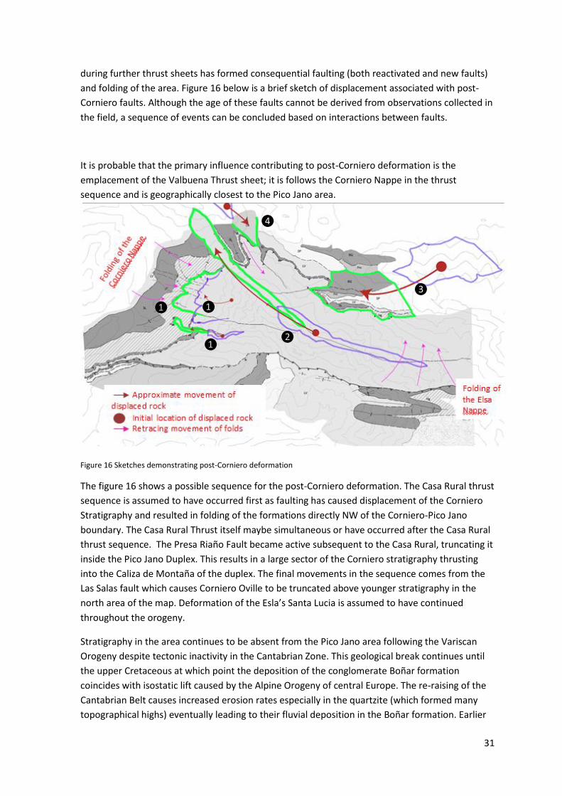
during further thrust sheets has formed consequential faulting (both reactivated and new faults)
and folding of the area. Figure 16 below is a brief sketch of displacement associated with post-
Corniero faults. Although the age of these faults cannot be derived from observations collected in
the field, a sequence of events can be concluded based on interactions between faults.
It is probable that the primary influence contributing to post-Corniero deformation is the
emplacement of the Valbuena Thrust sheet; it is follows the Corniero Nappe in the thrust
sequence and is geographically closest to the Pico Jano area.
Figure 16 Sketches demonstrating post-Corniero deformation
The figure 16 shows a possible sequence for the post-Corniero deformation. The Casa Rural thrust
sequence is assumed to have occurred first as faulting has caused displacement of the Corniero
Stratigraphy and resulted in folding of the formations directly NW of the Corniero-Pico Jano
boundary. The Casa Rural Thrust itself maybe simultaneous or have occurred after the Casa Rural
thrust sequence. The Presa Riaño Fault became active subsequent to the Casa Rural, truncating it
inside the Pico Jano Duplex. This results in a large sector of the Corniero stratigraphy thrusting
into the Caliza de Montaña of the duplex. The final movements in the sequence comes from the
Las Salas fault which causes Corniero Oville to be truncated above younger stratigraphy in the
north area of the map. Deformation of the Esla’s Santa Lucia is assumed to have continued
throughout the orogeny.
Stratigraphy in the area continues to be absent from the Pico Jano area following the Variscan
Orogeny despite tectonic inactivity in the Cantabrian Zone. This geological break continues until
the upper Cretaceous at which point the deposition of the conglomerate Boñar formation
coincides with isostatic lift caused by the Alpine Orogeny of central Europe. The re-raising of the
Cantabrian Belt causes increased erosion rates especially in the quartzite (which formed many
topographical highs) eventually leading to their fluvial deposition in the Boñar formation. Earlier
❶
❶ ❶
❷
❸
❹

32
deposition did occur on a regional scale after the Variscan Orogeny (Wallace, 1972) however, it is
not present in the Pico Jano area.

33
7.0. Acknowledgements
I would like to thank the University of Manchester for educating myself and providing the
framework allowing me to undertake this endeavour. I would also like to thank Dr. Simon
Brockelhurst for his continued support and guidance during the writing of this report and the 97%
grade I think we all know I deserve. I would also like to thank my parents for all the moral support
they gave during the trip (albeit often from the sofa situated 500 miles away), Tristan and John
for being just about bareable and to Marcus Frew for not murdering me in the night like he so
often said he would.

34
8.0. References
8.1. Literature
ALONSO, J. 1987. Sequences of thrusts and displacement transfer in the superposed duplexes of
the Esla Nappe region (Cantabrian Zone, NW Spain). Journal of Structural Geology, Vol.9(8),
pp.969-983
ÁLVARO, J.J ; Vennin, E ; Moreno-Eiris, E ; Perejón, A ; Bechstädt, T. 2000. Sedimentary patterns
across the Lower-Middle Cambrian transition in the Esla Nappe. These provide information on the
lithology, structure and carbonates respectively. Sedimentary Geology, 2000, Vol.137(1), pp.43-61
BRIEMER, Th, KRANS & N. SJERP. 1963. A New Stratigraphic Interpretation of Palaeozoic Sections
in the Region between San Isidro Pass and Tarna Pass (Province of Leon, Spain). Inst, Geol. Min.
Notas Comun., No. 70,131-5.
B. W. Logan, R. Rezak and R. N. Ginsburg.1964.Classification and Environmental Significance of
Algal Stromatolites. The Journ al of Geology., Vol.72, 68-83
COLMENARO, J. R. Suárez-Ruiz, I. Fernández-Suárez, J. Barba, P. Llorens, T. 2008. Genesis and rank
distribution of Upper Carboniferous coal basins in the Cantabrian Mountains, Northern Spain.
International Journal of Coal Geology., Vol.76, 187–204
COMTE, P. 1959. Reacherches sur les terrains anciens de la Cordillere Cantabrique. Mem. Inst.
Geol. Min. Esapna, 60, pp. 1 – 440.
Gasparrini, M. Bechsta, T. Boni, M. 2006. Massive hydrothermal dolomites in the southwestern
Cantabrian Zone (Spain) and their relation to the Late Variscan evolution Marine and Petroleum
Geology Vol. 23, 543–568
HIGGINS, A. C. 1962. Conodonts from the Griotte Limestone of NW. Spain. Notas Comun. Inst, geol. Min. Esp., 65, 5-22.
Rupke, J. 1965. The Esla Nappe, Cantabrian Mountains. Leidse Geologische Mededelingen, Vol. 32, 74. VAN ADRlCHEM BOOGAERT, H. A. 1967. Devonian and Lower Carboniferous Conodonts of the Cantabrian Mountains (Spain) and their Stratigraphic Application. Leid. Geol. Meded., 39, 129-92. WAGNER, R. H.In WAGNER, R. H. & J. I. ARTlEDA. 1970a. La Cuenca Miiiera CiheraMatallana. Sociedad Anonima Hullera Vasco-Leonesa, 288 pp.
WAGNER-GENTlS, C. H. T. 1963. Lower Namurian Goniatites from the Griotte Limestone of the Cantabric Mountain Chain. Notas Comun, Inst, geol. Min. Esp., 69, 5-42.
WALLACE, P. 1972. The Geology of the Palaeozoic Rocks of the South-Western Part of the Cantabrian Cordillera, North Spain. Proceedings of the Geologists’ Association .Vol 83, 1, 57–73.

35
WINKLER-PRINS, C. F. 1968. Carboniferous Productidina and Chonetidina of the Cantabrian Mountains (NW. Spain): Systematics, Stratigraphy and Palaeoecology. Leid. Geol, Meded., 43, 41-126.
8.2. Software
Adobe Illustrator
ArcGis Map10
Google Maps
Google Earth
Iberpix
Microsoft Word
Microsoft Excel
Paint
Stereo32