the history & lore of logan canyon podcast tour brochure
TRANSCRIPT

The History & Lore of Logan Canyon
Podcast Tour Brochure
P.O. Box 4204 2696 Hwy 89 Logan, UT 84323 435-755-3239
Download the podcasts on our website: www.logannature.org.
Introduction Stokes Nature Center (SNC) is proud to present the History & Lore of Logan Canyon tour and podcast. Take a tour through Logan Canyon and learn about its amazing history and fascinating lore! This brochure is designed to be used along with the History & Lore of Logan Canyon podcast series, which can be downloaded off the SNC website www.logannature.org. Or rent an mp3 player at SNC with the program already downloaded. Each podcast (or audio-recorded story) is linked to a specific site in the canyon where you can listen to the story while experiencing a piece of the history or lore that sill exists.
How this Brochure is Organized Each entry begins with the title of a podcast in the series, fol-lowed by the site to which it is linked. After this, there are GPS coordinates of the site and directions, beginning at the mouth of Logan Canyon. Refer to the map on the next page to see the gen-eral location of each site within the canyon (match the number on the map to the number of the podcast). The podcasts are listed in an order that will take you on the most direct route through the canyon. Doing them all at once will make for a very full day. Go in order or pick your own path. Unless otherwise noted, roads are paved and there are no fees to park. All mileages are approximate.
Where to Begin The tour begins at the Logan Ranger District and then heads east into Logan Canyon from Logan, Utah. For directions to Logan, Utah, visit mapquest.com. Directions to Logan Canyon: From 400 N. and Main Street in Logan, Utah, travel east on 400 N. This road will curve up past Utah State University, and you will see the Logan Ranger District on your right just before heading down the hill into Logan Can-yon.
Please travel safely and do not use headphones while driving.

Map of Logan Canyon The map below shows the general location of each site within the canyon. Match the number of the podcast (shown next to the title in each entry) with the number on the map. Podcasts 10 and 12 are not shown on the map because these pod-casts may be listened to at any location.
1. Too Many Sheep 2. Establishing a Forest Reserve 3. A Growing National Forest Site: Logan Ranger District Visitors Center Address: 1500 E. Hwy 89, at the top of the hill before you enter Logan Canyon Listen to these three stories about Logan Canyon’s national his-tory at the headquarters for our local National Forest.
Sheep Grazing in Logan Canyon, 1902, USDA Forest Service
Logan Ranger District Visitors Center
4. Stokes Nature Center's Beginnings Site: Stokes Nature Center GPS Coordinates: N 41.74179° W 111.76862° Directions: Follow Hwy 89 to mile marker 462. Watch for Stokes Nature Center signs. There will be a large Cache National Forest sign on the left side of the road. Park next to the sign, cross the highway, and walk 1/3 mile up the River Trail to the building.
Stokes Nature Center
Stokes Nature Center Renovation, 1996
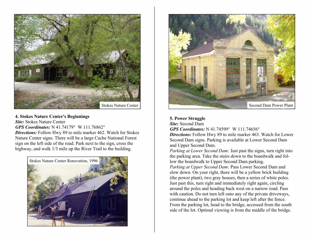
5. Power Struggle Site: Second Dam GPS Coordinates: N 41.74599° W 111.74656° Directions: Follow Hwy 89 to mile marker 463. Watch for Lower Second Dam signs. Parking is available at Lower Second Dam and Upper Second Dam. Parking at Lower Second Dam: Just past the signs, turn right into the parking area. Take the stairs down to the boardwalk and fol-low the boardwalk to Upper Second Dam parking. Parking at Upper Second Dam: Pass Lower Second Dam and slow down. On your right, there will be a yellow brick building (the power plant), two gray houses, then a series of white poles. Just past this, turn right and immediately right again, circling around the poles and heading back west on a narrow road. Pass with caution. Do not turn left onto any of the private driveways, continue ahead to the parking lot and keep left after the fence. From the parking lot, head to the bridge, accessed from the south side of the lot. Optimal viewing is from the middle of the bridge.
Second Dam Power Plant

6. Witch's Castle Site: Wind Caves GPS Coordinates: N 41.76294° W 111.71767° Directions: Follow Hwy 89 to mile marker 466. Watch for a sign that says “Guinavah-Malibu ½ mi.” Just past this on the left is the Wind Caves parking area and trailhead. Trail: Trail is well-maintained, 1.9 miles one way, and steep. Parts of the trail remain snow-covered until late spring/early sum-mer.
Wind Caves, by Bracken Berger
Hercules Power Plant, 1896, USU Special Collections 7. Forest Army Site: Guinavah-Malibu Campground Amphitheater GPS Coordinates: N 41.76172° W 111.69504° Directions: Follow Hwy 89 to mile marker 466. Watch for Guina-vah-Malibu sign on left and turn right into the campground (keep right at entryway to avoid severe tire dam-age). The sign straight ahead will have infor-mation, fee envelopes, and deposit box for parking fee ($8 for day use, for free parking, use the Wind Caves parking lot). Turn left. Park in a designated spot. When you reach the bridge, the road is closed; continue on foot. Cross the bridge and continue east. Watch for amphitheater signs. Path ends in a circle. Go right (south) up the stairs to the amphitheater. Distance is 1/2 mile from the entrance to the campground.
Guinavah-Malibu Campground Amphitheater
CCC Workers in Hyrum, UT, 1935, USDA Forest Service

8. Old Ephraim Site: Old Ephraim’s Grave Monument GPS Coordinates: N 41.76369° W 111.54348° Directions: Follow Hwy 89 to mile marker 476. Watch for Tem-ple Fork Road sign and turn right. There is parking and an infor-mation kiosk just down the dirt road and across the bridge. Mileages: 0.0 mi Parking area. 0.9 mi Fork in road, sign for Spawn Creek Trailhead; go right. 4.7 mi Fork in road; stay left. 6.4 mi Hunsaker Springs turnoff; continue straight on main road. 7.0 mi Major road junction, sign for Ephraim’s Grave; go right. 7.8 mi Turnoff to right; ignore. 9.7 mi Eprhaim’s Grave parking area on left. Monument is only a few meters from parking. Road: Mostly well-maintained gravel/dirt, appropriate for autos and mountain bikes. Last 3 mi. may be quite muddy in wet con-ditions.
Old Ephraim & Frank Clark Painting, Gleed Family
Old Ephraim’s
Grave Monument
9. Temple Sawmill Site: Temple Fork Sawmill Monument GPS Coordinates: N 41.80634° W 111.54243° Directions: Follow Hwy 89 to mile marker 476. Watch for the Temple Fork Road sign and turn right. There is an information kiosk just down the road across the bridge. Milages: 0.0 mi Parking area. 0.9 mi Fork in road, sign for Spawn Creek Trailhead; go left. 1.1 mi Temple Fork Sawmill trailhead parking. The monument site is 3 more miles along a trail that parallels a stream to the south (on your right as you head toward the saw-mill). Avoid trails that take you over a bridge off to your right until you are very near the monument site, which will be when the narrow canyon you’ve been in for 1/2 to 3/4 mi. opens up again. Road/Trail: Well-maintained gravel/dirt road to Temple Fork Sawmill trailhead. Trail is easy walking, with only short sections of uphill/rocky conditions.
Temple Fork Sawmill Monument

10. St. Anne's Ghost St. Anne’s Retreat is currently private property. However, many sightings of St. Anne’s Ghost have taken place along the highway and in other locations besides the retreat. Listen to this spooky story on your hike back from Temple Sawmill or during another segment of your journey.
Temple Sawmill, 1863, USU Special Collections
Camping in Logan Canyon, 1908, USU Special Collections
12. The Naming of Logan Canyon Listen to the story of how Logan Canyon got its name while en-joying beautiful Tony Grove or during another segment of your journey.
11. Road to Recreation Site: Tony Grove GPS Coordinates: N 41.89467° W 111.64228° Directions: Follow Hwy 89 to mile marker 480. Following signs to Tony Grove, turn left off the highway. Immediately, the road splits. Turn left. Travel 7 miles to the parking area. Parking fee: $5 (day use), $10 (overnight).
Tony Grove Lake

13. Beaver Mountain Ski Area Site: Beaver Mountain Ski Area GPS Coordinates: N 41.96835° W 111.54116° Directions: Follow Hwy 89 to mile marker 487, watch for signs to Beaver Mountain Ski Area. Turn left onto SR 243 and follow for 1.4 miles until you reach the Beaver Mountain Ski Area park-ing lot.
Beaver Mountain Ski Area, 2010, Seeholzer Family
Beaver Mountain Ski Area, 1952, Seeholzer Family
14. Plane Crash of 1953 Site: Plane Crash Memorial in Pat Hollow GPS Coordinates: N 41.96835° W 111.54116° Directions: Follow Hwy 89 to mile marker 487, watch for signs to Beaver Mountain Ski Area. Turn left onto SR 243, follow for 3/4 mile and take the dirt road turnoff on the right. Mileages: 0.0 mi Turnoff from SR 243 0.2 mi Sink Hollow turnoff to left; stay right. 4.2 mi Beaver Creek Camp-ground on right; continue straight. 5.9 mi Fork in road, sign for Egan Basin; go left. Immedi-ately after this, take right fork following the Plane Crash sign. 6.9 mi Circle of rocks; park. Memorial is about 50 yards ahead. Road: Dirt and gravel, very bumpy, may have large puddles of water depending on the season. High-clearance recommended.
Wreckage from Plane Crash, 1953, USU Special Collections
Plane Crash Memorial, Pat Hollow

15. Bear Lake Monster Site: Bear Lake Overlook GPS Coordinates: N 41.92119° W 111.45683° Directions: Follow Hwy 89 to mile marker 493, watch for Scenic Overlook signs. The overlook is on the right-hand side of the highway. Look for a large parking lot and a visitors center.
Bear Lake, Matthew Trump
Bear Lake Overlook and Visitor Center, National Scenic Byways
Special Thanks This program has received funding from the Utah Humanities Council. The Utah Humanities Council promotes understanding of diverse traditions, values, and ideas through informed public discussion. Special thanks to Elaine Thatcher of Utah State University’s Mountain West Center for sharing her time and expertise with us. Thank you to Randy Williams of Fife Folklore Archives at USU Special Collections. Voice Credits Val Grant, Bridgerland Audubon Society David Sidwell, StarHouse Discovery Center Children’s Museum Elaine Thatcher, Mountain West Center Lisa Thompson, Uinta-Wasatch-Cache National Forest Quotes by: Jim Akers, Stokes Nature Center
Sources of Information and Photos Bracken Berger Forest History Society Gleed Family Logan Library National Scenic Byways Program Seeholzer Family USDA Forest Service Utah State University Special Collections and Archives This program was produced by Annalisa Paul of Stokes Nature Center
Cover photo: Logan Forest Reserve Ranger, 1914, Forest History Society
Help us improve our programs! Please take a moment to fill out a feedback form—available at
www.logannature.org.