the infill and redevelopment code...
TRANSCRIPT
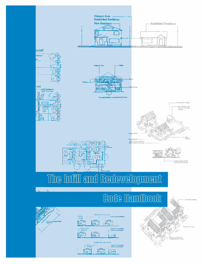
The Infill and Redevelopment Code Handbook
Transportation and Growth Management ProgramOregon Department of Transportation
Oregon Department of Land Conservation and Development
September, 1999
For further information, contact:
Transportation and Growth Management Program635 Capitol Street NE, Suite 150
Salem, OR 97301-2450Contact: Gloria Gardiner
Telephone: 503-373-0050, extension 282Fax: 503-378-2687
E-mail: [email protected]
Prepared by:
The Infill and Redevelopment Code Handbook
Sponsoring Agencies
This project was funded by the Oregon Transportation and Growth Management (TGM)Program, a joint program of the Oregon Department of Transportation and the OregonDepartment of Land Conservation and Development. The TGM Program relies upon onfunding from the federal Transportation Efficiency Act for the Twenty-First Century (TEA-21) and the Oregon Lottery.
TGM Program
Bill Adams, AICP, Urban Growth Mgmt. Specialist, TGM Project Manager Gloria Gardiner, JD, TGM Code Assistance Planner Elaine Smith, AICP, Urban Growth Program Manager
Infill and Redevelopment Advisory Committee
Mark Bello, Planner — City of Portland Scot Burns, President — Burns Development Company Peter Wilcox, AIA, Executive Director — Portland Community Design Linda Sarnoff, AICP, Planning Manager — City of Corvallis Scott Keillor, AICP, Transportation Planner — City of Gresham
Participating Planners, Developers and Architects (interviewed)
Jim Croteau, Allen Lowe — City of Eugene Jeff Lamb — Sienna Architects Kevin Gilles — Neighborhood Economic Development Corporation Mike McKeel, Gresham Developer Terry Brandt, Portland Developer Doug Oblitz, Portland Developer (Belmont Dairy) Anne Gilsky, Portland Developer (Ladd’s Addition Housing) Jeff Davis, Jim Wheeler, Ron Papsdorf — City of Gresham
Consultants
Scot Siegel, AICP, Project Manager, Senior Planner — Otak, Inc. Stacey Sacher-Goldstein, Planner — Otak, Inc. Tom Litster, Urban Designer — Otak, Inc. Martin Glastra van Loon, Urban Designer — Otak, Inc. Katie Kersten, Graphic Designer — Otak, Inc. Tom Armstrong, AICP, Planner — Pacific Rim Resources, Inc.
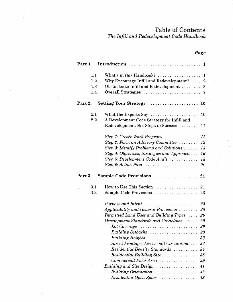
P a r t 1 — I n t r o d u c t i o n
T h e I n f i l l a n d R e d e v e l o p m e n t C o d e H a n d b o o k 1
Definitions
in•fill \’in-fill\ n : development ofvacant or remnant lands passed over byprevious development in urban areas.
re•de•vel•op•ment \red-i-’vel-ep-ment\n. the act or process ofredeveloping; esp : renovation of ablighted area. Replacement, remodeling,or reuse of existing structures toaccommodate new development.
Part 1 — Introduction
There are many good reasons why developers prefer to build on raw land, and some of thesereasons relate to local government policy. Even though there are greater economic, social andenvironmental costs to sprawl development than infill, our public policies have stacked theincentives in the wrong direction.
— from “Building Livable Communities: A Policymaker’s guide to infill development” (LocalGovernment Commission, 1995)
Efficient use of land is a key growth management objective for Oregon’s urbanareas. This handbook offers strategies for encouraging more infill andredevelopment. (See sidebar for definitions.) In particular, it provides tools forremoving barriers to infill and redevelopment in a community’s development codes. The step-by-step process in the handbook is intended for city planners, planningcommissioners, and consultants who are involved in updating land use codes fortheir communities.
1.1 What’s in This Handbook?
This handbook provides a comprehensive program for identifying and removingbarriers to infill and redevelopment in urban areas. It is organized into threecomponents: Part 1 (this part) summarizes the
benefits of, and common obstaclesto, infill and redevelopment, andprovides a range of strategies foraddressing those obstacles.
Part 2 contains a step-by-stepprocess for reviewing localconditions in your community, andcreating an action plan for infilland redevelopment.
Part 3 offers sample code languagefor removing regulatory barriers toinfill and redevelopment andimproving compatibility betweenexisting and new developments.
The handbook was prepared with the assistance of an advisory committeecomprised of architects, developers and city planners. The committee memberswere interviewed individually and met as a group to provide input on the contentand format of the handbook. In addition, the authors interviewed builders,architects and planners who have experience designing, reviewing, and developing
2 T h e I n f i l l a n d R e d e v e l o p m e n t C o d e H a n d b o o k
infill and redevelopment projects in Oregon. We wanted to find out “what works” inpromoting this type of development. For a list of committee members andinterviewees, please see the inside of the front cover.
1.2 Why Encourage Infill and Redevelopment?
Every city and urban county in Oregon should have a strategy to encourage infilland redevelopment. First, it is state policy to plan for efficient use of land andpublic facilities within urban growth boundaries. (Please refer to the Appendix for asummary of relevant policies.) Infill and redevelopment is a basic component of acommunity’s buildable lands inventory, and is appropriate in areas where thecommunity has invested in public infrastructure.
Second, and most importantly, infill and redevelopment can support several localand regional planning objectives, including:
Economic development and improved tax base. Revitalization of downtown and close-in neighborhoods. Development of needed housing in close proximity to employment and services Neighborhood preservation and enhancement Transportation choices and connectivity Walkable neighborhoods and, where applicable, transit-supportive
development Decrease in commuter road congestion Efficient use of existing urban services and facilities, as an alternative to
extending new facilities Energy conservation through reduced reliance on the automobile Completing communities, and providing community centers Public cost savings (i.e., over sprawl development)
Finally, infill and redevelopment make good economic sense, both for developersand the public. Even the real estate community is turning its attention to ways thatit can encourage infill and redevelopment. In a report entitled Emerging Trends forReal Estate 1999, Pricewaterhouse Coopers and Lend Lease Real EstateInvestments condemn sprawl and low-density suburban residential centers:“Suburbs struggle because they have let developers run amok, oblivious to trafficgrowth, sewer system capacity or even recreational needs,” the report warns. “Increasingly, better suburban centers are starting to look like smaller versions oftraditional cities, featuring attractive neighborhoods, easily accessible retail andoffice districts, and mass transportation alternatives to the car.” Emerging Trendsis based on a survey of 150 leading industry investors, developers, space users, andanalysts across the United States.
Part 1 - Introduction
T h e I n f i l l a n d R e d e v e l o p m e n t C o d e H a n d b o o k 3
1.3 Obstacles to Infill and Redevelopment
In Building Livable Communities: A Policymaker’s Guide to Infill Development, TheLocal Government Commission’s Center for Livable Communities identifies sixoverarching obstacles to infill and redevelopment (paraphrased from BuildingLivable Communities):
� Six Obstacles Stacking the Deck Against Infill and Redevelopment
1. Infill and redevelopment projects often cost more to build than raw landprojects — Hard costs, such as land, site preparation (i.e., demolition or toxics),construction, and parking vary widely but generally run more for infill andredevelopment. Typically soft costs, such as survey, architecture, engineering,legal, permitting, and marketing, also run more due to design challenges and publicprocess requirements inherent to infill and redevelopment projects. The marginalcost of infill may be greater than for development on the edge of the urban area, inpart, because the number of units being produced is usually much less than wouldbe built in a new community. While permitting costs may be roughly the same foreach project, infill projects must pay them out of a smaller projected return oninvestment.
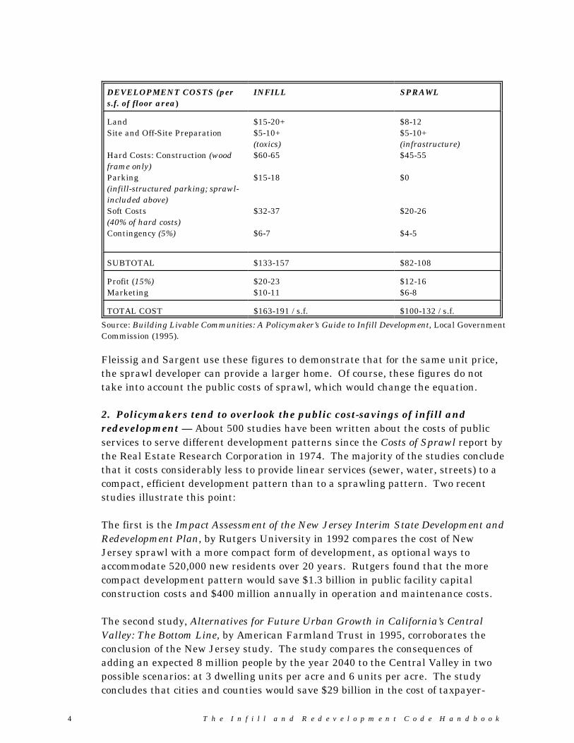
Developers Tom Sargent and Will Fleissig have summarized the costs per squarefoot of infill and development versus sprawl. Their 1993 figures for the Bay Area inCalifornia are provided on page 4.
4 T h e I n f i l l a n d R e d e v e l o p m e n t C o d e H a n d b o o k
DEVELOPMENT COSTS (pers.f. of floor area)
INFILL SPRAWL
LandSite and Off-Site Preparation
Hard Costs: Construction (woodframe only)Parking(infill-structured parking; sprawl-included above)Soft Costs(40% of hard costs)Contingency (5%)
$15-20+$5-10+(toxics)$60-65
$15-18
$32-37
$6-7
$8-12$5-10+(infrastructure)$45-55
$0
$20-26
$4-5
SUBTOTAL $133-157 $82-108
Profit (15%)Marketing
$20-23$10-11
$12-16$6-8
TOTAL COST $163-191 / s.f. $100-132 / s.f.
Source: Building Livable Communities: A Policymaker’s Guide to Infill Development, Local GovernmentCommission (1995).
Fleissig and Sargent use these figures to demonstrate that for the same unit price,the sprawl developer can provide a larger home. Of course, these figures do nottake into account the public costs of sprawl, which would change the equation.
2. Policymakers tend to overlook the public cost-savings of infill andredevelopment — About 500 studies have been written about the costs of publicservices to serve different development patterns since the Costs of Sprawl report bythe Real Estate Research Corporation in 1974. The majority of the studies concludethat it costs considerably less to provide linear services (sewer, water, streets) to acompact, efficient development pattern than to a sprawling pattern. Two recentstudies illustrate this point:
The first is the Impact Assessment of the New Jersey Interim State Development andRedevelopment Plan, by Rutgers University in 1992 compares the cost of NewJersey sprawl with a more compact form of development, as optional ways toaccommodate 520,000 new residents over 20 years. Rutgers found that the morecompact development pattern would save $1.3 billion in public facility capitalconstruction costs and $400 million annually in operation and maintenance costs.
The second study, Alternatives for Future Urban Growth in California’s CentralValley: The Bottom Line, by American Farmland Trust in 1995, corroborates theconclusion of the New Jersey study. The study compares the consequences ofadding an expected 8 million people by the year 2040 to the Central Valley in twopossible scenarios: at 3 dwelling units per acre and 6 units per acre. The studyconcludes that cities and counties would save $29 billion in the cost of taxpayer-
Part 1 - Introduction
T h e I n f i l l a n d R e d e v e l o p m e n t C o d e H a n d b o o k 5
financed services over a 45 year period if housing developed at an average density of6 units per acre rather than 3 units per acre. These findings underscore the needfor policymakers to consider public costs, as well as private costs, in planning forinfill and redevelopment.
3. Largely due to past experience with poor quality examples, manycommunity members actively oppose infill and mixed-use projects — ThePolicymakers Guide describes this frustration: “In the past, local governments havefocused on regulations relating to particular uses and densities rather than payingattention to the much more important issues of scale, landscaping and, mostimportant of all, the relationship of the building to the lot upon which it sits, to therest of the street, and to the neighborhood. In other cases, there have been few orno regulations at all regarding what might be built where. The unpleasant resultshave become indelibly imprinted in the minds of many citizen[s]. Residents mayalso have some very legitimate concerns about reduced air quality, increased traffic,more parked cars, and overuse of civic buildings and parks.”
4. Developers often avoid infill or redevelopment projects in inner-cityneighborhood due to fear of reduced marketability — A three-year studyundertaken by the Urban Land Institute of six low-income, inner-city neighborhoodsrevealed that low quality of education and crime most strongly contribute toneighborhood decline. Poor quality infill development, lack of code enforcement,blight, and a lack of neighborhood were seen as contributing to the problem.
5. Finance and capital markets can be a barrier to the infill developer —Lenders perceive mixed-use projects appropriate to infill development as risky whenthere are not many similar projects to which they can be compared. The problem iscompounded by the fact that many banks separate their residential and commercialloan functions, so individual loan officers are not familiar with all elements of theproject. Additionally, most lenders are unwilling to count much of the potentialrental income from retail/commercial space toward revenues to support a loan,because lenders are concerned the space will not actually lease.
Mortgages of infill projects are also difficult to sell to the secondary market (FannieMae, Freddie Mac, etc.). The secondary market sets the underwriting standards formost loans and these quasi-public institutions do not tend to underwritecondominiums, townhouses, live-work units, co-ops, co-housing, mixed-usedevelopments, and the like.
6. Zoning for separate uses has gone too far — The Euclidean zoning model of“separating uses” began as a response to industrial pollution and diminishingquality of life in inner cities. The model spread across the county in the early 1900s,prohibiting different types of housing to mix, and isolating neighborhoods from jobs,
6 T h e I n f i l l a n d R e d e v e l o p m e n t C o d e H a n d b o o k
stores and services. Today, the practice of separating land uses and prescribinginflexible lot area, building setback, and other dimensional standards has resultedin barriers to compatible infill and mixed use developments. The Policymaker’sGuide argues that this way of thinking is outdated and goes too far. “Usually nosingle regulation is at fault; it is the sum total of all the ordinances andregulations.”
� Conclusion: It’s time to “Even the Playing Field”
Current public policies generally provide incentives and subsidies for raw-land orgreenfield development. A capital improvement program that directs water,roadway, and sanitary sewer projects to greenfield development sites, whileneglecting needed improvements in infill areas, is one example of this type of policy. Zoning and subdivision regulations that contemplate development of large, flatparcels, but neglect the challenges and opportunities of infill sites, are anotherexample. This handbook suggests strategies to “even the playing field,” by makinginfill and redevelopment a more reasonable choice for a developer as building onraw land on the fringes of the community.
Part 1 - Introduction
T h e I n f i l l a n d R e d e v e l o p m e n t C o d e H a n d b o o k 7
1.4 Overall Strategies
In a strong real estate market, infill and redevelopment may occur withoutsupportive public policies. More often, coordination of public policies and privateinvestment is required to encourage development of under-used and skipped-overareas. Such areas may be targeted for infill and redevelopment when adequatepublic facilities are available, or can be made available. There may also be activeneighborhood support. The area may be important for economic, social, or culturalreasons. Under any of these scenarios, the public and the development communitycan benefit from strategies that encourage well-planned infill and redevelopment.
Two strategies are addressed in detail in Part 3 - Sample Code Provisions:
� Changes in Regulations — Streamlining and customizing regulations to fitthe particular needs of infill and redevelopment reduces barriers and providesincentives to quality development.
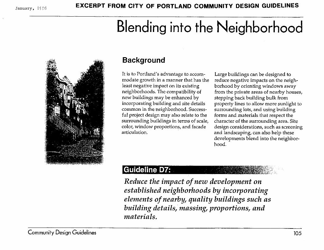
� Infill Design Guidelines/Standards — The compatibility of new buildingsmay be enhanced by incorporating building and site details common in theneighborhood. Appropriate building scale, materials, color, windowproportions, and facade articulation, for example, all contribute tocompatibility. Large buildings can be designed to reduce negative impacts onthe neighborhood by orienting windows away from private areas of nearbyhouses, stepping back building bulk from property lines to allow more sunlightto surrounding lots, and using building forms and materials that respect thecharacter of the surrounding area. Screening and landscaping can also helpnew developments blend into the neighborhood.
Other strategies include:
� Specific Area Plans — Specific area plans (or Refinement Plans per ORS197.200) are comprehensive plan components, similar to sub-area plans. Theyare developed through a consensus process with property owners and otherinterest groups, and provide a vision with specific implementation measures.Specific area plans can encourage quality infill and redevelopment, forexample, by providing clear direction in land use, design, transportation, andinfrastructure elements.
� Site Assessments and Inventories — Local governments can assist the realestate and development industry to focus investment in infill andredevelopment by preparing site assessments and land use/developmentinventories. Maps of underutilized (vacant, infill, and redevelopable) land thatare prepared during comprehensive plan updates and neighborhood studies
8 T h e I n f i l l a n d R e d e v e l o p m e n t C o d e H a n d b o o k
can be of value to prospective developers. This information can besupplemented with spreadsheets containing key site selection data, such assite size, access, rail and other transportation features, utilities, ownership,physical opportunities and constraints, and entitlement history (e.g., land useapprovals, environmental assessments, traffic and natural resource studies).
� Infill Marketing — Local governments can work with developers to advertiseand promote infill and redevelopment sites identified in the site assessmentsand inventories. Such “marketing” can be as active or passive as isappropriate for the particular community. For example, cities with activeurban renewal agencies may be able to dedicate significant resources toadvertising (i.e., particularly when the agency is offering land fordevelopment), whereas other cities may simply provide inventory andassessment data over the counter, or on a web site.
� Design Assistance — Design assistance can range from providing diagrams,pictures, and sample designs (i.e., “this will work”), to preparing complex siteplans, computer simulations and modeling (e.g., transportation, drainage, etc.)tailored to individual projects. These types of services can assist developers inprotecting neighborhood character and complying with local regulations.
� Capital Improvement Plans — A Capital Improvement Plan (CIP) showsthe location and timing of planned public facility improvements. CIPs can beused to focus on specific infill and redevelopment areas for capital projectssuch as street, utility, and public amenity improvements.
� Annexation Plans and Urban Service Agreements — Annexation plansand urban service agreements can help in areas where gaps in service existbetween multiple cities or special service districts. The agreements facilitateinfill and redevelopment by clarifying the roles of service providers andstreamlining development review.
� Marginal Cost Pricing — A reduction to system development charges andsimilar fees and exactions may be warranted for some types of projects and intown center locations (e.g., transit oriented developments, mixed use projects,etc.). Such “marginal cost pricing” reflects lower real costs to the community,as compared to open land development at the city’s edge. The cost reductionmay also encourage a developer to purse an infill or redevelopment project thathe or she would not otherwise consider, since this type of project often involvesa more lengthy, and less certain permitting and financing process.
� Financial Incentives — Financial incentives (i.e., beyond Marginal CostPricing) are often necessary to induce redevelopment in blighted areas, and inareas where there is a high expectation for public benefits or amenities. Costreductions and subsidies may include, but are not limited to, public

Part 1 - Introduction
T h e I n f i l l a n d R e d e v e l o p m e n t C o d e H a n d b o o k 9
The next section of this handbook describes an overall process for setting aninfill and redevelopment strategy for your community, with an emphasis onimplementing the first two strategies suggested above: Changes in Regulationsand Infill Design Guidelines/Standards.
improvement cost-sharing; land acquisition and write-downs; tax credits andabatement; low-interest loans and other financial incentives; application feereductions or waivers; and expedited permit processing. These types ofsubsidies should be offered only when the development advances a legitimatepublic purpose (e.g., affordable housing, public space, transit-orienteddevelopment, etc.).
� Property Tax Exemptions for Qualified Housing — Oregon’s housing andcommunity services statutes, ORS 458, govern community developmentcorporations, state housing revitalization programs, low-income housing funds,and various community services programs in Oregon distressed and low-income areas. Of note, ORS 458.005-.065 enables cities to implement propertytax exemptions and limitations for new housing in distressed urban areaswhen design standards are in place and other criteria are met.
� Urban Renewal — Oregon’s urban renewal statute (ORS 457) allows anurban renewal agency for every municipality in the state, and authorizes taxincrement financing. The statute enables a local government to activate itsurban renewal agency after making a finding of “blight”. The agency thenprepares an urban renewal plan. Under the plan, it may borrow funds, collecttax revenue, and carry out projects that revitalize blighted areas. For a moredetailed description of eligible areas, please refer to ORS 457 in the Appendix.
� Forming Partnerships — Local governments can partner with otheragencies and organizations that have a mutual interest in promoting infill andredevelopment. By joining forces with housing and social service agencies,neighborhood and business district leaders, building trade groups, and designprofessionals, a local government can tap into a wealth of experience andresources. (See also, “Form an Advisory Committee”, page 12.).
P a r t 2 — S e t t i n g Y o u r S t r a t e g y
1 0 T h e I n f i l l a n d R e d e v e l o p m e n t C o d e H a n d b o o k
Part 2 — Setting Your Strategy
2.1 Overview: What the Experts Suggest
The authors of this handbook interviewed builders, architects and local governmentplanners with infill and redevelopment project experience to get their input on localplanning policies and development codes. We wanted to know: “what works well.” (For a list of interviewees, please refer to the inside of the front cover.) The topseven conclusions of the interviews are as follows:
1. Need for Planning — Communities need to plan for infill and redevelopmentdue to the complexity of this type of development and its importance in termsof meeting growth management objectives.
2. Audit Codes — City planners and developers agree that development codesare often too limited and inflexible when applied to infill and redevelopmentprojects. Obstacles include outdated and conflicting subdivision, zoning, andpublic works standards; building codes; and review procedures that take toolong, particularly for small projects. A development code “audit” isrecommended to identify barriers to infill and redevelopment. Audits providea comprehensive review of all facets of the development code, includingstandards and procedures for zoning, land divisions, and public improvements.
3. Physical Constraints Require Flexible Standards and Procedures —Odd-shaped lots, close building orientation, steep topography, poor access,brownfields, and a multitude of other site constraints require flexibility andcreative design solutions. At the same time, it is important to recognize thatsome sites may not be fully developable. Administrative variances oradjustment procedures can be provided in local codes to address the mostdifficult sites and opportunities to improve design quality. (See the City ofPortland.)
4. Design-Based Planning — Developers, designers, and public planners, willbe more successful with infill and redevelopment if they use the local designcontext in planning their projects. This sensitivity to local conditions goeshand-in-hand with the need for flexibility in local development codes. (Seeabove.) Graphics should be included in zoning and subdivision codes tocommunicate design standards and make codes easier to use.
5. Incentives — Financial incentives may be necessary for some infill projects,particularly affordable housing projects. For information on financial, tax andother incentives, please refer to “Overall Strategies” in Section 1.4 of thishandbook.
Part 2 - Setting Your Strategy
T h e I n f i l l a n d R e d e v e l o p m e n t C o d e H a n d b o o k 11
6. Neighborhood Support — Neighbors will support good projects when theyfeel that the project benefits them. Public education and good examples topoint to are critical.
7. The Human Element — Staff and local policy makers need to have afavorable attitude toward infill and redevelopment to get good results.
2.2 A Development Code Strategy for Infill andRedevelopment: Six Steps to Success
This section outlines a process to define the extent of the problems andopportunities related to infill and redevelopment, and potential constraints thatexist in the community. When a developer conducts a site feasibility study he or shelooks at “opportunities” and “constraints” — i.e., Is the site served with utilities? Does it have the necessary zoning and access? Is it steep or wet? What is thesurrounding development like? A community’s evaluation of infill andredevelopment lands should follow the same process. This handbook suggests thefollowing six steps:
� Step 1: Create a Work Program� Step 2: Form an Advisory Committee� Step 3: Identify Problems and Potential Solutions� Step 4: Determine Objectives and Strategies� Step 5: Audit the City’s Development Codes� Step 6: Your Action Plan
The process used by individual cities and counties will vary depending on localneeds and available data. The handbook suggests working with an advisorycommittee comprised of local officials, development interests and communityneighborhood leaders. The planner or analyst in charge of this work should be ableto conduct a land use/buildable lands inventory and interpret economic, naturalresource, demographic, housing, and code-related data from a variety of sources.The results of this work can be displayed in a variety of formats. While GeographicInformation Systems can provide great speed and efficiency for larger studies, hand-crafted maps can work just as well for smaller areas.
The following six steps provide a basic approach for creating an infill andredevelopment strategy for your community:
1 2 T h e I n f i l l a n d R e d e v e l o p m e n t C o d e H a n d b o o k
� Step 1: Create a Work Program
The work program should describe the intent and substance of the project, studyarea, roles and responsibilities of the participants, schedule, budget, and products. This step is particularly important when the local government anticipates hiring aconsultant.
� Step 2: Form an Advisory Committee
An advisory committee can assist planners and decision-makers by:– ensuring that the code audit addresses important issues and includes
perspectives from the full range of interests;– reviewing and commenting on findings; and– supporting public involvement efforts as part of the code-revision and
implementation process.
Think of an advisory committee as providing a “360-degree” review of your city’sregulations and development process. A committee can look at your city’sregulations from many perspectives and offer valuable insight. Cities shouldconsider appointing representatives from the following agencies and interestgroups to provide a complete review:
� Development review staff — Those who review developments and enforcedevelopment codes (planners, building officials, engineering and public worksstaff), as well as those who write policies and codes, should be involved in thecode audit.
� Urban service providers — Agency staff who are responsible for water,sewer, stormwater management, parks, schools, libraries, crime prevention,private utilities, and similar service should be involved, as applicable.
� Developers — Involve developers who have experience developing infill andredevelopment projects in your community, if possible, and elsewhere.
� Private architects and planners — They work with your code and know itsstrengths and weaknesses. They may also know what other communities aredoing to encourage infill and redevelopment.
� Community services and housing providers — Housing authorities, non-profit housing providers, community development corporations/banks, andother community service agencies should be involved because they are oftencatalysts for infill and redevelopment.
Part 2 - Setting Your Strategy
T h e I n f i l l a n d R e d e v e l o p m e n t C o d e H a n d b o o k 13
� Realtors and lenders — Real estate and lending institutions (e.g., banks,savings and loans, credit unions, mortgage companies) can provide valuableinsight on the market-feasibility of proposed development policies and codes.
� Citizen stakeholders — Involving key neighborhood and business leaderscan help the city draw on their collective expertise and ensure that they arebrought along in the code revision process.
An infill and redevelopment advisory committee can meet as often as is practicaland appropriate for the scope of your code project. Committee members mayprovide one-on-one assistance to planning staff as technical advisors, as well asmeeting with the group at key milestones to discuss draft findings and makerecommendations. City planners may find it useful to survey committee members,prior to beginning the code audit, to find out what they perceive as key issues andpriorities.
� Step 3: Identify Problems and Potential Solutions
The following questions are designed to gather information on the obstacles to infilland redevelopment and potential solutions. Your advisory committee can providevaluable insight by brainstorming responses to the questions. The questions areorganized in three layers: Economic, Physical, and Regulatory. This handbooksuggests mapping the key findings of your brainstorm session. (See map exampleon page 14)
� Economic Issues. Begin by considering market factors and socioeconomictrends that may explain recent infill and redevelopment, or the lack thereof.– Compare property values in the area. Are assessed “land values” greater
than “improvement values” for many parcels, indicating redevelopmentpotential?
– What is the occupancy history of buildings in the subject area? Arebuildings vacant because they are no longer functional for past users? Havesome buildings become obsolete due to neglect and changes in marketpreferences?
– Do property owners owe back-taxes? Should some properties be condemned?– What is the ownership status of redevelopment sites? While not a code issue,
local ownership can help facilitate public-private redevelopment.– Could some “blighted” or “distressed” areas benefit from urban renewal or
other development incentives?– Should there be an urban renewal district, enterprise or empowerment zone? – Is the area deficient with regard to other factors of importance to industry,
retail, office, and residential location, etc.?
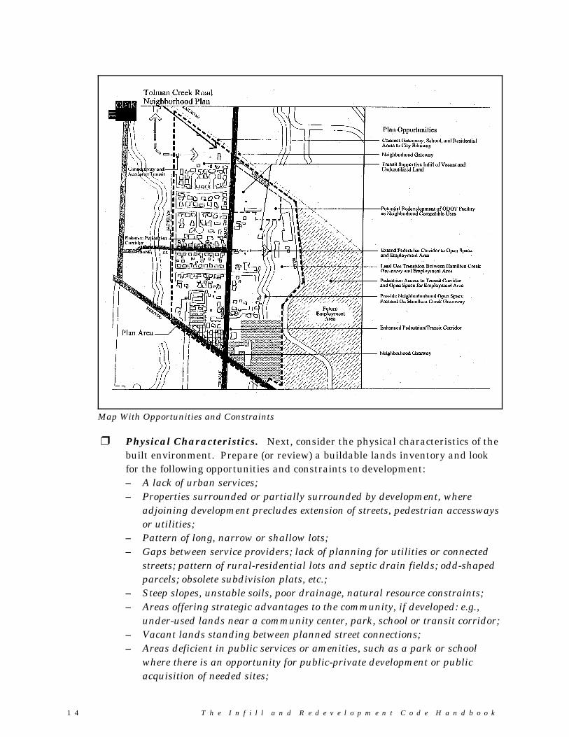
1 4 T h e I n f i l l a n d R e d e v e l o p m e n t C o d e H a n d b o o k
Map With Opportunities and Constraints
� Physical Characteristics. Next, consider the physical characteristics of thebuilt environment. Prepare (or review) a buildable lands inventory and lookfor the following opportunities and constraints to development:– A lack of urban services;– Properties surrounded or partially surrounded by development, where
adjoining development precludes extension of streets, pedestrian accesswaysor utilities;
– Pattern of long, narrow or shallow lots;– Gaps between service providers; lack of planning for utilities or connected
streets; pattern of rural-residential lots and septic drain fields; odd-shapedparcels; obsolete subdivision plats, etc.;
– Steep slopes, unstable soils, poor drainage, natural resource constraints;– Areas offering strategic advantages to the community, if developed: e.g.,
under-used lands near a community center, park, school or transit corridor;– Vacant lands standing between planned street connections;– Areas deficient in public services or amenities, such as a park or school
where there is an opportunity for public-private development or publicacquisition of needed sites;
Part 2 - Setting Your Strategy
T h e I n f i l l a n d R e d e v e l o p m e n t C o d e H a n d b o o k 15
What do we do with all the information once it is mapped?Once the information from your brainstorming session is mapped, consider writing a briefissues paper to present to your advisory committee. Their comments will help in definingyour community’s strategy for an infill and redevelopment in Step 4.
– Properties with a history of contamination, indicating severe risk toprospective developers;
– Buildings that require upgrades (e.g., earthquakes, accessibility, other fireand building code upgrades).
� Regulatory Barriers. Finally, consider whether your community’sexperience in applying development codes to infill and redevelopment projectsexplains anything about why the land is underutilized. For example (otherquestions may apply):
– Do existing regulations address the physical constraints identified in thecommunity/neighborhood?
– Does existing development (i.e., uses, buildings, parcels, layout, etc.) complywith zoning and other land use standards?
– Do current zoning and subdivision standards allow development at planneddensities? If not, why?
– Do review procedures create a hardship for infill development (i.e., ascompared to greenfield sites)?
– Do regulations (e.g., zoning, subdivision, land use, etc.) allowadministrative flexibility? If applicable, which standards preventedapproval of specific infill or redevelopment projects?
1 6 T h e I n f i l l a n d R e d e v e l o p m e n t C o d e H a n d b o o k
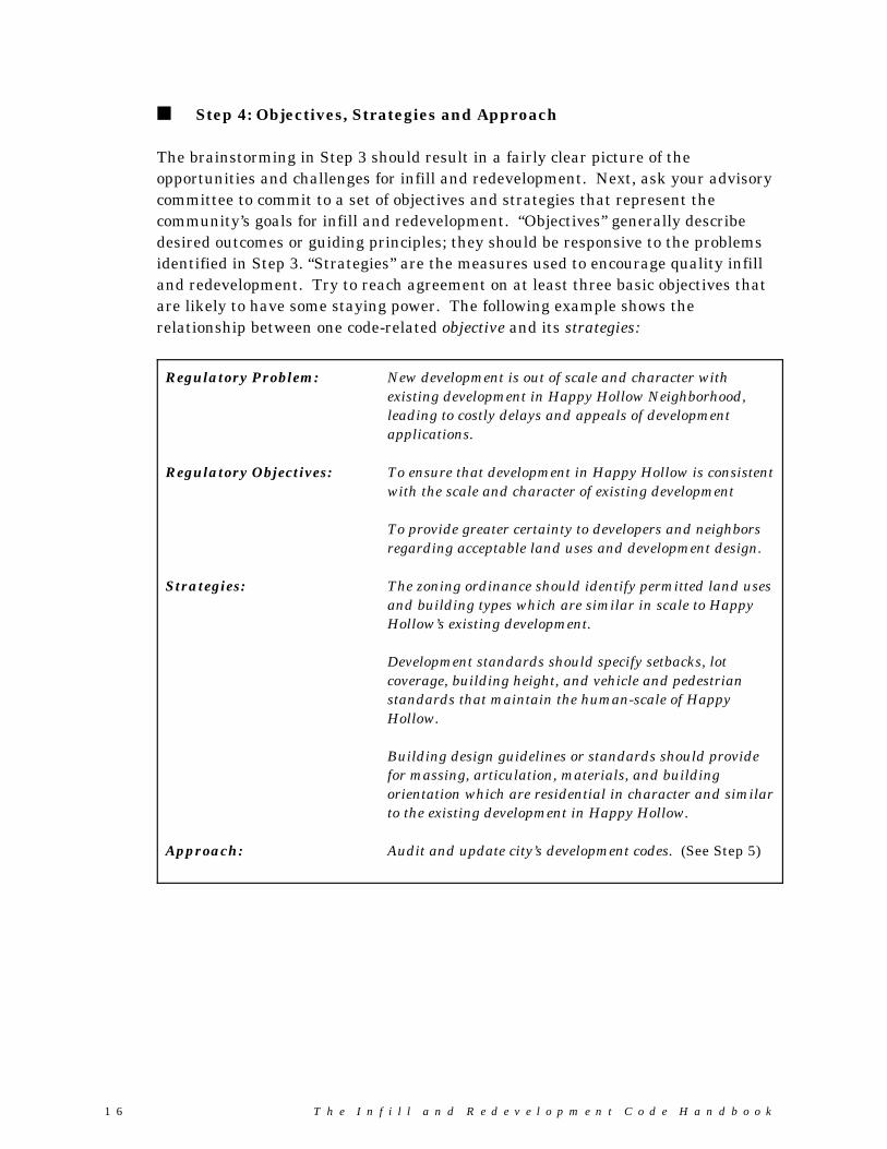
� Step 4: Objectives, Strategies and Approach
The brainstorming in Step 3 should result in a fairly clear picture of theopportunities and challenges for infill and redevelopment. Next, ask your advisorycommittee to commit to a set of objectives and strategies that represent thecommunity’s goals for infill and redevelopment. “Objectives” generally describedesired outcomes or guiding principles; they should be responsive to the problemsidentified in Step 3. “Strategies” are the measures used to encourage quality infilland redevelopment. Try to reach agreement on at least three basic objectives thatare likely to have some staying power. The following example shows therelationship between one code-related objective and its strategies:
Regulatory Problem: New development is out of scale and character withexisting development in Happy Hollow Neighborhood,leading to costly delays and appeals of developmentapplications.
Regulatory Objectives: To ensure that development in Happy Hollow is consistentwith the scale and character of existing development
To provide greater certainty to developers and neighborsregarding acceptable land uses and development design.
Strategies: The zoning ordinance should identify permitted land usesand building types which are similar in scale to HappyHollow’s existing development.
Development standards should specify setbacks, lotcoverage, building height, and vehicle and pedestrianstandards that maintain the human-scale of HappyHollow.
Building design guidelines or standards should providefor massing, articulation, materials, and buildingorientation which are residential in character and similarto the existing development in Happy Hollow.
Approach: Audit and update city’s development codes. (See Step 5)
Part 2 - Setting Your Strategy
T h e I n f i l l a n d R e d e v e l o p m e n t C o d e H a n d b o o k 17
Process Note: Gauging Consensus
It is important to gauge consensus among advisory committee members early in theprocess. In some communities, the notion of encouraging development may be contraryto some long-standing community values, while in others there may be a strong desirefor revitalization of older neighborhoods. In any event, it is important to provideinformation to the community about the benefits of infill and redevelopment, andcheck-in early for consensus on the project objectives. In some communities, membersof the city council or planning commission will take an interest in the project andshould be encouraged to participate.
What about problems that can not be addressed by new or reviseddevelopment regulations?
The above example offers a regulatory approach to a regulatory problem. Someproblems related to the market and physical conditions of the landscape will requireother solutions (e.g., the need to update the capital improvement program; adoptingfinancial incentives, better information regarding natural hazards or contaminatedsites, etc.) While the remaining sections of this handbook focus on ways to improvedevelopment codes, it is important to set objectives for those non-regulatoryproblems as well.
.

1 8 T h e I n f i l l a n d R e d e v e l o p m e n t C o d e H a n d b o o k
Process Note: Advisory CommitteeInvolvement in the Audit
Advisory committee members canassist by completing audit worksheets,reviewing and commenting on casehistories (particularly if they wereinvolved in the project), and byparticipating in a simulated review. Developer representatives, from bothpublic and private sectors, may be ableto contribute projects for “simulated”reviews (either from the localcommunity or positive models fromother communities). The committeemember should have an opportunity toreview and comment on the staff’sevaluation and auditrecommendations.
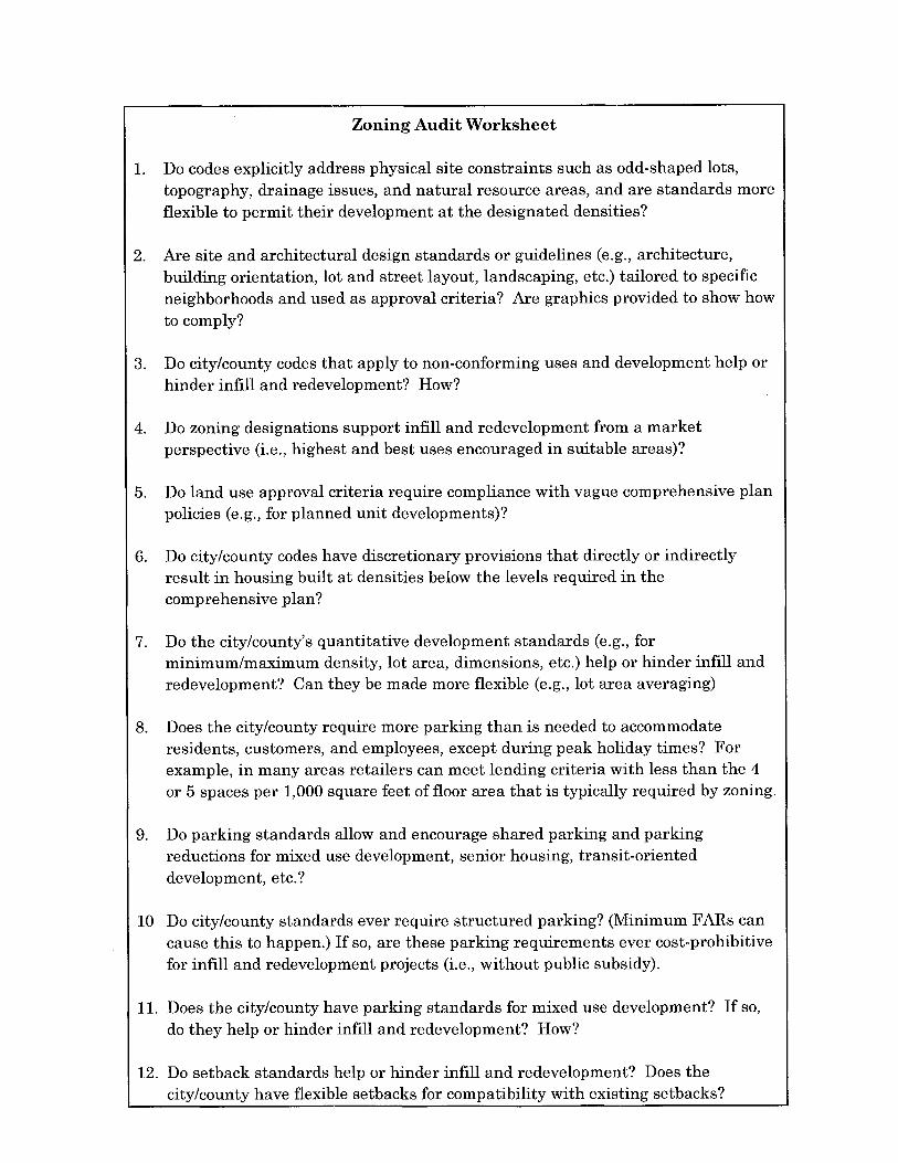
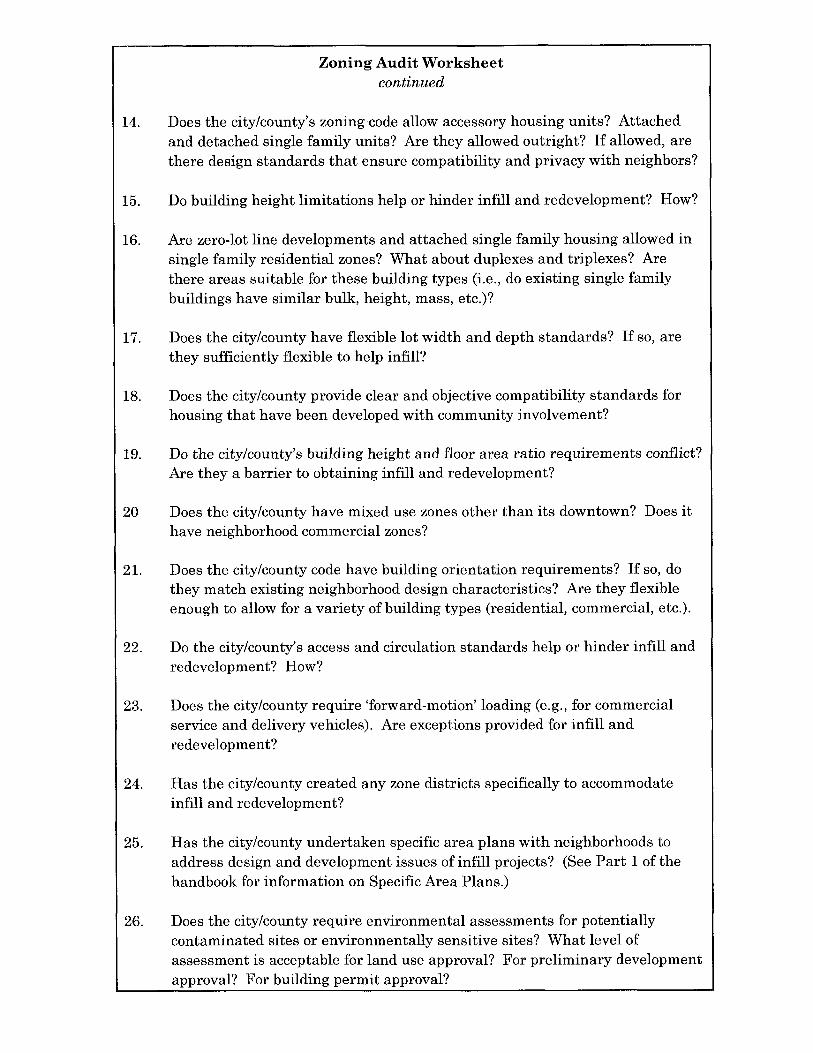
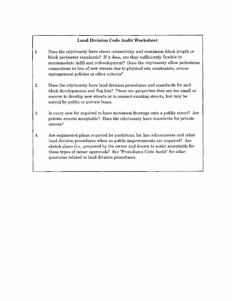
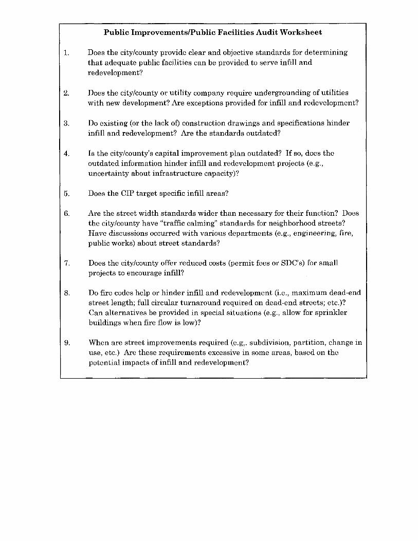
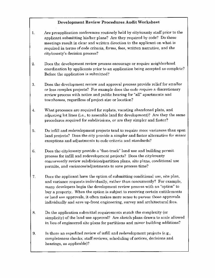
� Step 5: Development Code Audit
Once your community has identified objectives for infill and redevelopment, acomprehensive “code audit” should be completed. A code audit is a review of existingplan policies, development standards, and permit procedures to determine whichones are working well, and which ones need to be replaced to meet the community’sobjectives for infill and redevelopment. This following community planning processis suggested for identifying appropriate code changes:
� Use worksheets to review code sections — Appendix A provides sampleworksheets for auditing the following types of codes:– Zoning codes– Land division codes– Public improvement standards– Development review procedures
(these may be integrated with othercodes)
� Test existing codes using case studies— Case studies use real or hypotheticaldevelopments to evaluate the strengthsand weaknesses of the development codeand permitting processes. The followingcase study methods are suggested:
– Case History Approach. The “casehistory” approach reviews pastdevelopment projects andapplications to identify codeobstacles. Simply pull arepresentative sample of infill andredevelopment project applications,including those which wereapproved, denied, and withdrawn. Develop a list of questions to ask abouteach development, based on the objectives and strategies defined in “Step4", above. This approach will be most effective for cities with a history ofinfill and redevelopment. Local governments with less experience, maywant to tour other communities with good examples of built projects, andsurvey their local governments to find out what they do differently.
– Simulated Project Review. The “simulated project” approach uses real orhypothetical development programs and site plans to test regulations andapproval procedures. The proposal may come from a willing developer orarchitect with stock or custom plans, or it may be a built project from acomparable community (ask: “can it be built here?”). The simulation should
Part 2 - Setting Your Strategy
T h e I n f i l l a n d R e d e v e l o p m e n t C o d e H a n d b o o k 19
be as close to an actual development review as possible, with volunteersplaying the part of developer/applicant, staff reviewers, neighborhoodrepresentative, etc. The simulation may even include a facilitated “mockhearing”, in which planning commissioners (or their advisory committeedoubles) accept testimony and evaluate the project based on existingpolicies and standards. While time-consuming, everyone can learn a greatdeal from this exercise and it’s fun!
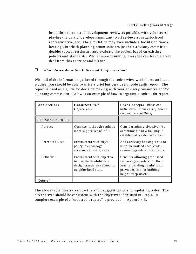
� What do we do with all the audit information?
With all of the information gathered through the code review worksheets and casestudies, you should be able to write a brief but very useful code audit report. Thereport is used as a guide for decision making with your advisory committee and/orplanning commission. Below is an example of how to organize a code audit report:
Code Sections Consistent WithObjectives?
Code Concepts - [these arebullet-level statements of how toremove code conflicts]
R-10 Zone (Ch. 20.10)
- Purpose Consistent, though could bemore supportive of infill
Consider adding objective: “toaccommodate new housing inestablished residential areas.”
- Permitted Uses Inconsistent with city’spolicy to encourageaccessory housing units
Add accessory housing units tolist of permitted uses, cross-referencing related standards.
- Setbacks Inconsistent with objectiveto provide flexibility anddesign standards related toneighborhood scale.
Consider allowing graduatedsetbacks (i.e., related to floorarea or building height), andprovide option for buildingheight “step-down”.
[Others]
The above table illustrates how the audit suggest options for updating codes. Thealternatives should be consistent with the objectives identified in Step 4. Acomplete example of a “code audit report” is provided in Appendix B.
2 0 T h e I n f i l l a n d R e d e v e l o p m e n t C o d e H a n d b o o k
Process Note: Work Plans for CodeRevisions
A work plan should include at least the followingthree basic parts:
Scope of code revisions, including code sectionsto be revised, key concepts to be incorporated,number of drafts, and review and adoptionprocess.
Schedule coordinated with planning commissionand city council work programs;
Budget with staff hours estimated by task; thisis particularly important when the cityanticipates hiring a consultant.
It may be difficult to revise city codes duringperiods of heavy development activity. In somecases, it may be cost-prohibitive for a localgovernment to hire a consultant. However, asdescribed earlier in the workbook, code changesto encourage infill and redevelopment often canbe made with very little effort. For those caseswhere more effort is required, Oregon’sTransportation and Growth ManagementProgram offers financial assistance through agrant-in-aid Code Assistance Program.
� Step 6: Your Action Plan
The code audit in Step 5 should provide ample evidence of what your communitycan do to facilitate infill and redevelopment. What the community decides to doabout this information is really the most important part of the process. Beforesetting a strategy to revise the code, your advisory committee should considerwhether their infill and redevelopment objectives (Step 4) are still valid. The auditresults should be used, in part, to validate or update the objectives set in Step 4, asnecessary. If the audit reveals significant, unanticipated issues, then the objectivesmay need to be refined and the audit revised accordingly.
Next, determine what actions areneeded to achieve the objectives. Code revisions, as well as severalother actions, may be appropriateas part of an overall infill andredevelopment strategy. Considerwhether there is a need for:
� Zoning revisions, updates tosubdivision and public worksstandards, and proceduralchanges;
� Public information andeducation about infill andredevelopment;
� Organizational changeswithin the planning orcommunity developmentdepartment (e.g., “one-stoppermit center”);
� Staff training anddevelopment;
� Changes to fee schedules,system development charges,etc.; and
� Changes to comprehensive plans, adoption of specific area plans, and similarpolicy changes.
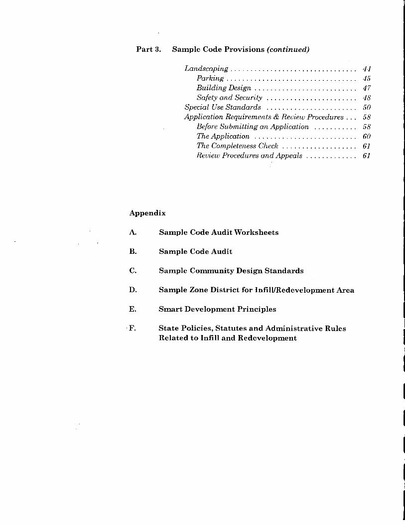
P a r t 3 — S a m p l e C o d e P r o v i s i o n s
T h e I n f i l l a n d R e d e v e l o p m e n t C o d e H a n d b o o k 21
Part 3 — Sample Code Provisions
3.1 How to Use This Section
This section provides sample code provisions for infill and redevelopment. The codelanguage is not exhaustive. Rather it is intended to illustrate options for updatingselected zoning, subdivision, and procedural requirements based on the followinggeneric code sections:
� Purpose and Intent� Applicability and General Provisions� Permitted Land Uses and Building Types� Development Standards and Guidelines� Application Requirements and Review Procedures� Adjustments and Variances
� How to Apply the Code Provisions
The sample code provisions can be used to:
� Create new zone districts or overlay zones that are oriented to infill andredevelopment; or
� Update existing zone districts and other local land use codes to implementredevelopment and infill objectives.
There are two general methods for applying the model codes in this handbook — bydefinition and by district. The method that your community selects will dependupon the scope of your proposed code changes.
Applying Codes “By Definition” — Infill and redevelopment areas may be definedwithin the text of applicable land use ordinances without mapping specific areas.When used this way, model code provisions may be used city-wide, or they can belimited to specific zone districts.
The strength of this approach is that it is flexible, and does not require a zoningboundary decision (i.e., infill standards apply to all areas meeting the definition). Apotential weakness is that the definition may not address the specific needs of thecommunity. The approach is most useful when code changes are narrowly focusedand do not include changes to permitted land uses (e.g., standards for flag lots orset-back averaging can be applied by definition).
2 2 T h e I n f i l l a n d R e d e v e l o p m e n t C o d e H a n d b o o k
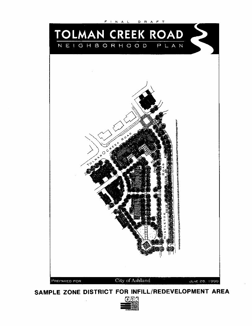
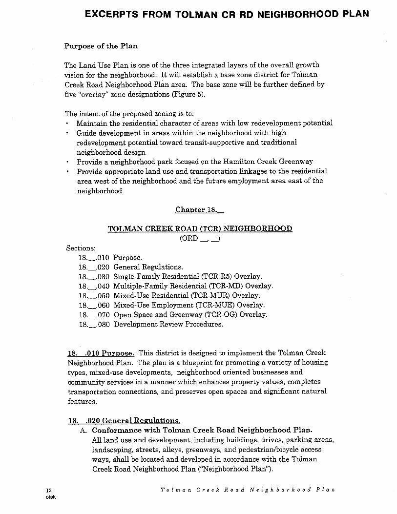
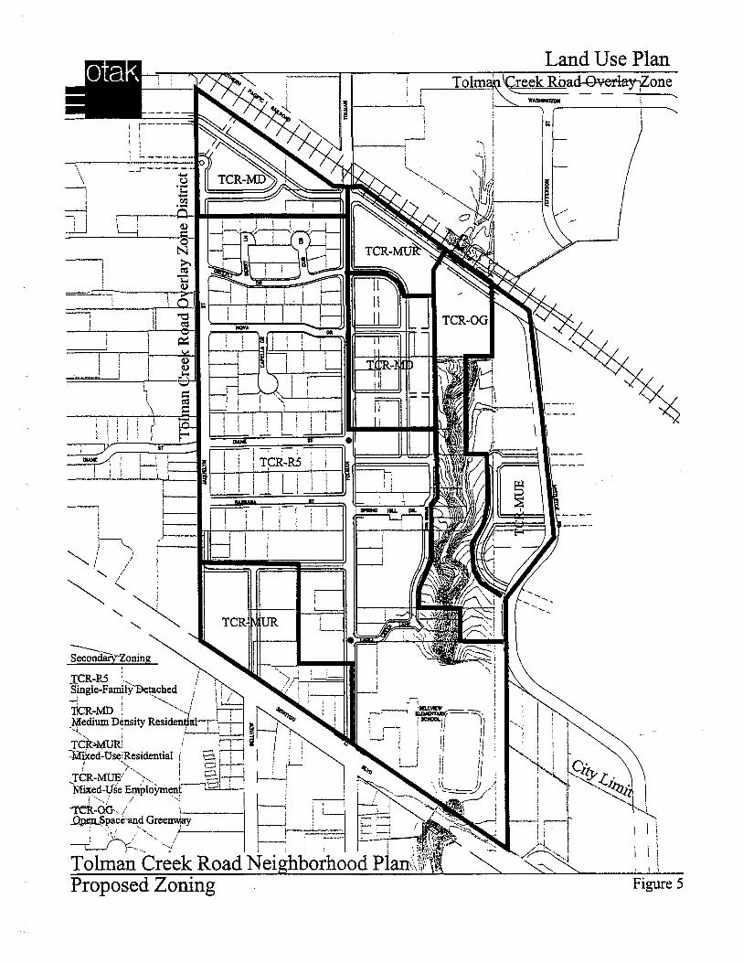
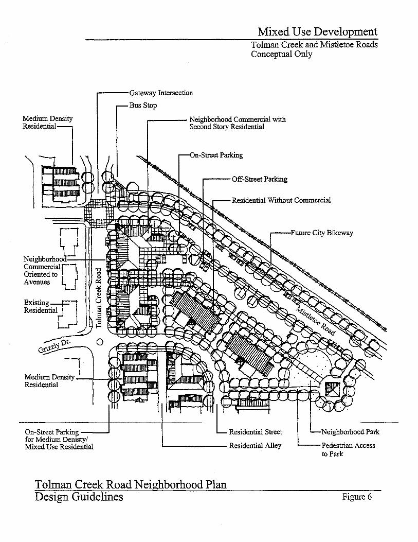
Applying Codes “By District” — Infill and redevelopment areas can also bemapped as discrete zone districts, or overlay zones. In practice, the adoption of aspecial land use “district” typically follows a community planning process for aspecific neighborhood or sub-area. The district name, for example, could relate tothe adopted plan, as was done for the City of Ashland’s Tolman Creek RoadNeighborhood Plan and Overlay Zone District. (Please refer to the example inAppendix D.)
The strength of the “district” approach is that it applies to a well-defined area, forwhich there is clear policy direction supporting infill and redevelopment. The zonedistrict can incorporate design standards that are tailored to a neighborhood,commercial/mixed-use center, or industrial area. This option works best when thecode update is part of a larger community planning effort (i.e., one that addressesland use, transportation, urban design, etc.).
ConclusionA community may decide to use either or both of the options described above. Forexample, the “district” approach may be useful for addressing specific neighborhoodobjectives (e.g., design compatibility), while the broader “definition” approach maybe useful for addressing city-wide infill objectives (e.g., setback averaging and flaglot standards). This handbook is intended to assist communities in preparing bothtypes of code updates.
� Format of This Section
Under each code section, the handbook provides examples of:� problem statements,� objectives,� code writing strategies, and� sample code provisions (as applicable).
Sample code language is shown in italics. Where the handbook identifies codelanguage options, the options are enclosed with [brackets]. Brackets are also usedto identify a range of appropriate standards. Blanks (“__”) serve as placeholders fortext to be developed by the community.
Part 3 - Sample Code Provisions
T h e I n f i l l a n d R e d e v e l o p m e n t C o d e H a n d b o o k 23
3.2 Sample Code Provisions
� Purpose and Intent
Purpose and Intent statements in land use codes are important from a legal andpolicy standpoint. The statements translate the policy intent of the comprehensiveplan into regulations, and provide direction to decision-makers for interpretingcodes and making discretionary decisions. A clear purpose and intent statementcan also help in clarifying the legal and policy basis for land use decisions whenthey are challenged. The sample code language in this section is intended to beused in writing an infill/redevelopment-oriented zoning district.
Problem: The zoning ordinance lists broad, subjective purpose statements, suchas: ensuring neighborhood compatibility; maintaining harmony andcharacter; and ensuring growth in an orderly and desirable manner.While these are all legitimate public purposes, the zoning ordinance issilent on infill and redevelopment. This has had the unintendedconsequence of discouraging this type of development.
Objective: To clarify that one of the purposes of the zoning ordinance is toaccommodate or encourage infill and redevelopment, consistent withthe Comprehensive Plan.
Strategy: Incorporate purpose statements into the zoning and subdivisionordinances that support infill and redevelopment.
2 4 T h e I n f i l l a n d R e d e v e l o p m e n t C o d e H a n d b o o k
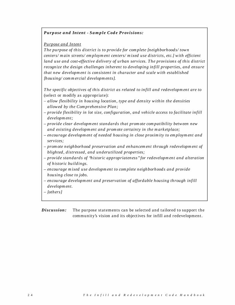
Purpose and Intent - Sample Code Provisions:
Purpose and IntentThe purpose of this district is to provide for complete [neighborhoods/towncenters/main streets/employment centers/mixed use districts, etc.] with efficientland use and cost-effective delivery of urban services. The provisions of this districtrecognize the design challenges inherent to developing infill properties, and ensurethat new development is consistent in character and scale with established[housing/commercial developments].
The specific objectives of this district as related to infill and redevelopment are to(select or modify as appropriate):– allow flexibility in housing location, type and density within the densities
allowed by the Comprehensive Plan;– provide flexibility in lot size, configuration, and vehicle access to facilitate infill
development;– provide clear development standards that promote compatibility between new
and existing development and promote certainty in the marketplace;– encourage development of needed housing in close proximity to employment and
services;– promote neighborhood preservation and enhancement through redevelopment of
blighted, distressed, and underutilized properties;– provide standards of “historic appropriateness” for redevelopment and alteration
of historic buildings.– encourage mixed use development to complete neighborhoods and provide
housing close to jobs.– encourage development and preservation of affordable housing through infill
development.– [others]
Discussion: The purpose statements can be selected and tailored to support thecommunity’s vision and its objectives for infill and redevelopment.
Part 3 - Sample Code Provisions
T h e I n f i l l a n d R e d e v e l o p m e n t C o d e H a n d b o o k 25
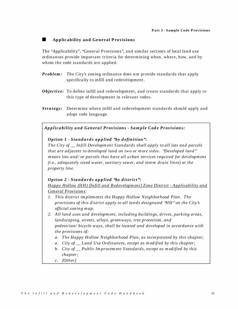
� Applicability and General Provisions
The “Applicability”, “General Provisions”, and similar sections of local land useordinances provide important criteria for determining when, where, how, and bywhom the code standards are applied.
Problem: The City’s zoning ordinance does not provide standards that applyspecifically to infill and redevelopment.
Objective: To define infill and redevelopment, and create standards that apply tothis type of development in relevant codes.
Strategy: Determine where infill and redevelopment standards should apply andadopt code language.
Applicability and General Provisions - Sample Code Provisions:
Option 1 - Standards applied “by definition”:The City of __ Infill Development Standards shall apply to all lots and parcelsthat are adjacent to developed land on two or more sides. “Developed land”means lots and/or parcels that have all urban services required for development(i.e., adequately sized water, sanitary sewer, and storm drain lines) at theproperty line.
Option 2 - Standards applied “by district”:Happy Hollow (HH) [Infill and Redevelopment] Zone District - Applicability andGeneral Provisions:1. This district implements the Happy Hollow Neighborhood Plan. The
provisions of this district apply to all lands designated “HH“ on the City’sofficial zoning map.
2. All land uses and development, including buildings, drives, parking areas,landscaping, streets, alleys, greenways, tree protection, andpedestrian/bicycle ways, shall be located and developed in accordance withthe provisions of:a. The Happy Hollow Neighborhood Plan, as incorporated by this chapter;a. City of __ Land Use Ordinances, except as modified by this chapter;b. City of __ Public Improvement Standards, except as modified by this
chapter;c. [Other]

2 6 T h e I n f i l l a n d R e d e v e l o p m e n t C o d e H a n d b o o k
Discussion:Option 1 (“by definition”) is appropriate for addressing citywide infill objectives(e.g., setback averaging and flag lots), Option 2 (“by district”) is appropriate foraddressing specific neighborhood objectives (e.g., design compatibility).
� Permitted Land Uses and Building Types
By broadening the range of land uses permitted within zone districts, localgovernments can remove barriers to infill and redevelopment. The followingexamples identify land uses that are often left out of zoning districts, or faceobstacles due to discretionary approval criteria. These uses can either be permittedoutright, or conditionally permitted subject to specific standards. The lists shouldbe tailored to fit the community vision, and made consistent with local zoningterminology.
� Residential Zones
Problem: Current residential zoning is inconsistent with the Happy HollowNeighborhood Plan, which envisions a mix of housing types and asmall-scale neighborhood commercial uses. Attached housing (e.g.,townhomes, duplexes, etc.), small-scale neighborhood commercial uses,and accessory dwellings are either prohibited or require discretionaryapproval.
Objective: To encourage a broader range of land uses and building types in HappyHollow Neighborhood consistent with planned housing densities, andestablish appropriate standards for location, building intensity, design,etc.
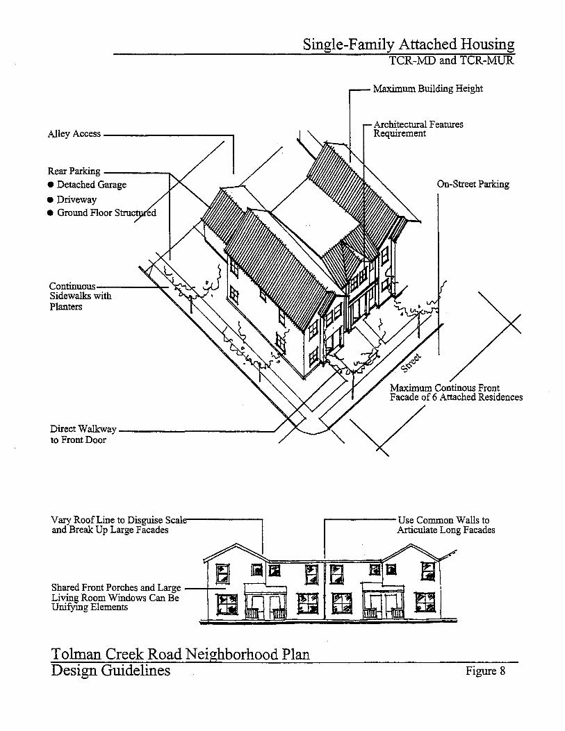
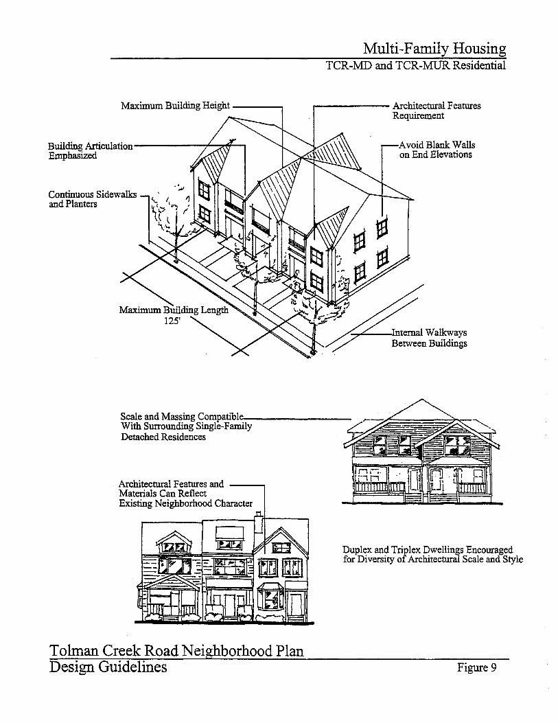
Strategy: Add the following uses to the existing zone(s), or create a zone forHappy Hollow Neighborhood that allows these uses:• Duplexes and triplexes on corner lots;• Zero-lot line housing;• Attached single family (townhome) units that are similar to
duplexes and triplexes in size and character;• Accessory dwellings (e.g., secondary housing units located above a
garage, in a detached cottage, or attached to the primary residence);and
• Neighborhood commercial uses (e.g., individual businesses do notexceed 3,000 square feet in floor area).
Discussion:As compared to other areas in the community, infill and redevelopment areasshould allow a wider range of uses. Areas designated for low density residential use
Part 3 - Sample Code Provisions
T h e I n f i l l a n d R e d e v e l o p m e n t C o d e H a n d b o o k 27
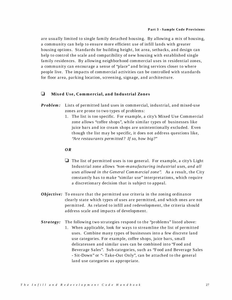
are usually limited to single family detached housing. By allowing a mix of housing,a community can help to ensure more efficient use of infill lands with greaterhousing options. Standards for building height, lot area, setbacks, and design canhelp to control the scale and compatibility of new housing with established singlefamily residences. By allowing neighborhood commercial uses in residential zones,a community can encourage a sense of “place” and bring services closer to wherepeople live. The impacts of commercial activities can be controlled with standardsfor floor area, parking location, screening, signage, and architecture.
� Mixed Use, Commercial, and Industrial Zones
Problem: Lists of permitted land uses in commercial, industrial, and mixed-usezones are prone to two types of problems:1. The list is too specific. For example, a city’s Mixed Use Commercial
zone allows “coffee shops”, while similar types of businesses likejuice bars and ice cream shops are unintentionally excluded. Eventhough the list may be specific, it does not address questions like,“Are restaurants permitted? If so, how big?”
OR
� The list of permitted uses is too general. For example, a city’s LightIndustrial zone allows “non-manufacturing industrial uses, and alluses allowed in the General Commercial zone”. As a result, the Cityconstantly has to make “similar use” interpretations, which requirea discretionary decision that is subject to appeal.
Objective: To ensure that the permitted use criteria in the zoning ordinanceclearly state which types of uses are permitted, and which ones are notpermitted. As related to infill and redevelopment, the criteria shouldaddress scale and impacts of development.
Strategy: The following two strategies respond to the “problems” listed above:1. When applicable, look for ways to streamline the list of permitted
uses. Combine many types of businesses into a few discrete landuse categories. For example, coffee shops, juice bars, smalldelicatessen and similar uses can be combined into “Food andBeverage Sales”. Sub-categories, such as “Food and Beverage Sales- Sit-Down” or “- Take-Out Only”, can be attached to the generalland use categories as appropriate.
2 8 T h e I n f i l l a n d R e d e v e l o p m e n t C o d e H a n d b o o k
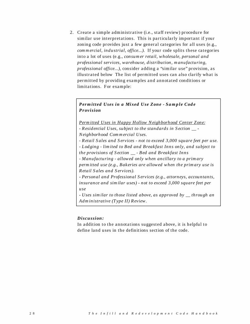
Permitted Uses in a Mixed Use Zone - Sample CodeProvision
Permitted Uses in Happy Hollow Neighborhood Center Zone:- Residential Uses, subject to the standards in Section __ -Neighborhood Commercial Uses.- Retail Sales and Services - not to exceed 3,000 square feet per use.- Lodging - limited to Bed and Breakfast Inns only, and subject tothe provisions of Section __ - Bed and Breakfast Inns- Manufacturing - allowed only when ancillary to a primarypermitted use (e.g., Bakeries are allowed when the primary use isRetail Sales and Services).- Personal and Professional Services (e.g., attorneys, accountants,insurance and similar uses) - not to exceed 3,000 square feet peruse- Uses similar to those listed above, as approved by __ through anAdministrative (Type II) Review.
2. Create a simple administrative (i.e., staff review) procedure forsimilar use interpretations. This is particularly important if yourzoning code provides just a few general categories for all uses (e.g.,commercial, industrial, office...). If your code splits these categoriesinto a lot of uses (e.g., consumer retail, wholesale, personal andprofessional services, warehouse, distribution, manufacturing,professional office...), consider adding a “similar use” provision, asillustrated below The list of permitted uses can also clarify what ispermitted by providing examples and annotated conditions orlimitations. For example:
Discussion:In addition to the annotations suggested above, it is helpful todefine land uses in the definitions section of the code.
Part 3 - Sample Code Provisions
T h e I n f i l l a n d R e d e v e l o p m e n t C o d e H a n d b o o k 29
� Development Standards and Guidelines
The sample development standards and guidelines provided below are intended to“level the playing field” between infill/redevelopment sites and open-land sites atthe city’s edge. The suggested code provisions are generally more flexible thanconventional land use regulations, due to the complexity and site-specific nature ofinfill and redevelopment.
� Lot Coverage
Conventional zoning ordinances typically regulate lot coverage, along with lot area,shape, and dimensions (i.e., width, depth, width at building line, etc.), to control thebulk and mass of developments. Lot coverage standards may be set too low orconflict with other standards, such as floor area ratios and building heights.
Problem: The lot coverage standards in the Low Density Residential (R-1) zone(40 percent) and Medium Density Residential (R-2) zone (60 percent)are set too low for attached housing (e.g., townhomes, duplexes, etc.) inHappy Hollow Neighborhood. Some pre-existing, small lots under oneacre cannot be developed under current standards
Objective: To provide lot standards that respond to pre-existing, small lots, andreflect the range of permitted land uses in Happy Hollow; i.e., singlefamily detached, multiple family, and attached (townhome, duplex andtriplex) housing.
Strategy: Provide flexible lot coverage standards based on building type and lotsize, and define “lot coverage” in the zoning ordinance. Exempt somearchitectural features from the lot coverage standards that contributeto streetscape character (e.g., front porches, overhangs, porticos,balconies, etc.).
3 0 T h e I n f i l l a n d R e d e v e l o p m e n t C o d e H a n d b o o k
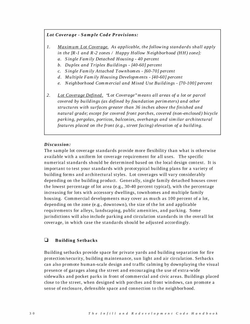
Lot Coverage - Sample Code Provisions:
1. Maximum Lot Coverage. As applicable, the following standards shall applyin the [R-1 and R-2 zones / Happy Hollow Neighborhood (HH) zone]:a. Single Family Detached Housing - 40 percentb. Duplex and Triplex Buildings - [40-60] percentc. Single Family Attached Townhomes - [60-70] percentd. Multiple Family Housing Developments - [40-60] percente. Neighborhood Commercial and Mixed Use Buildings - [70-100] percent
2. Lot Coverage Defined. “Lot Coverage” means all areas of a lot or parcelcovered by buildings (as defined by foundation perimeters) and otherstructures with surfaces greater than 36 inches above the finished andnatural grade; except for covered front porches, covered (non-enclosed) bicycleparking, pergolas, porticos, balconies, overhangs and similar architecturalfeatures placed on the front (e.g., street facing) elevation of a building.
Discussion:The sample lot coverage standards provide more flexibility than what is otherwiseavailable with a uniform lot coverage requirement for all uses. The specificnumerical standards should be determined based on the local design context. It isimportant to test your standards with prototypical building plans for a variety ofbuilding forms and architectural styles. Lot coverages will vary considerablydepending on the building product. Generally, single family detached houses coverthe lowest percentage of lot area (e.g., 30-40 percent typical), with the percentageincreasing for lots with accessory dwellings, townhomes and multiple familyhousing. Commercial developments may cover as much as 100 percent of a lot,depending on the zone (e.g., downtown), the size of the lot and applicablerequirements for alleys, landscaping, public amenities, and parking. Somejurisdictions will also include parking and circulation standards in the overall lotcoverage, in which case the standards should be adjusted accordingly.
� Building Setbacks
Building setbacks provide space for private yards and building separation for fireprotection/security, building maintenance, sun light and air circulation. Setbackscan also promote human-scale design and traffic calming by downplaying the visualpresence of garages along the street and encouraging the use of extra-widesidewalks and pocket parks in front of commercial and civic areas. Buildings placedclose to the street, when designed with porches and front windows, can promote asense of enclosure, defensible space and connection to the neighborhood.

Part 3 - Sample Code Provisions
T h e I n f i l l a n d R e d e v e l o p m e n t C o d e H a n d b o o k 31
Problem: The setbacks in new development vary noticeably from those of existingbuildings in Happy Hollow. Variances are often required to approvewhat was permitted for existing development nearby.
Objective: To provide setback provisions for infill that are tailored to HappyHollow.
Strategy: Study the built environment of Happy Hollow and identify typicalsetbacks. Pay special attention to the attributes that make theneighborhood desirable (e.g., garage are setback behind buildingentrances, and detached from some houses), and create standards thatsupport compatible relationships between new and old buildings.
Building Setbacks - Sample Code Provisions:
The following front yard setbacks apply within the Happy Hollow Neighborhood(HH) Zone District.
1. Front Yard Setbacks for New Residential Developments: The followingstandards shall apply to “new residential developments”. New residentialdevelopments are those that take place on lots created by partition orsubdivision after [(date) / the effective date of this ordinance]:a. A minimum setback of 10 feet is required. The maximum setback allowed
is 20 feet. b. Garages and carports shall be accessed from alleys, or otherwise recessed
behind the front building elevation (i.e., living area or covered frontporch) by a minimum of 6 feet.
c. The building orientation standards in Section __ shall apply to all newbuildings.
Continued...
3 2 T h e I n f i l l a n d R e d e v e l o p m e n t C o d e H a n d b o o k
Building Setbacks - Sample Code Provisions (continued)
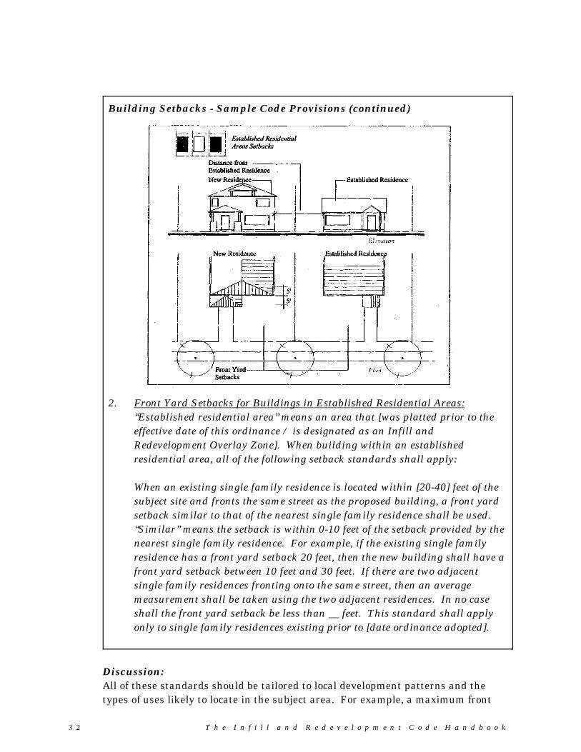
2. Front Yard Setbacks for Buildings in Established Residential Areas:“Established residential area” means an area that [was platted prior to theeffective date of this ordinance / is designated as an Infill andRedevelopment Overlay Zone]. When building within an establishedresidential area, all of the following setback standards shall apply:
When an existing single family residence is located within [20-40] feet of thesubject site and fronts the same street as the proposed building, a front yardsetback similar to that of the nearest single family residence shall be used. “Similar” means the setback is within 0-10 feet of the setback provided by thenearest single family residence. For example, if the existing single familyresidence has a front yard setback 20 feet, then the new building shall have afront yard setback between 10 feet and 30 feet. If there are two adjacentsingle family residences fronting onto the same street, then an averagemeasurement shall be taken using the two adjacent residences. In no caseshall the front yard setback be less than __ feet. This standard shall applyonly to single family residences existing prior to [date ordinance adopted].
Discussion:All of these standards should be tailored to local development patterns and thetypes of uses likely to locate in the subject area. For example, a maximum front
Part 3 - Sample Code Provisions
T h e I n f i l l a n d R e d e v e l o p m e n t C o d e H a n d b o o k 33
setback of “0" may be appropriate only in downtown and main street areas wherethe existing buildings are placed on the property line.
� Building Heights
Building height standards should be tailored to the specific neighborhood or planarea where they will apply. It is important to study the built environment, identifyattributes that are desirable, and create standards that support compatiblerelationships between new and old.
Problem: The 25-foot building height limit prevents approval of infill townhomesbuilt on narrow lots. Where alley access is not possible, these buildingstypically require garages on the ground-floor with split-level livingareas. The standard prevents construction of this type of townhomeunless the garage is below grade and building height is measured fromnatural grade. In addition, current standards discourage creative infilldesign by not providing exceptions for decorative architectural features(e.g., cupolas, cornices, gabled roofs, etc.). However setting the heightstandard too high will lead to conflicts with existing single-story homes.
Objective: To allow planned building types and provide incentives for creativedesign, while ensuring compatibility between existing buildings andnew, taller buildings.
Strategy: Establish building height standards that address grade variations andarchitectural elements (e.g., gabled roofs, cornices, parapets, cupolas,etc.). Adopt a code provision for “stepping-down” taller buildings toprovide a transition to existing single-story buildings, as applicable.
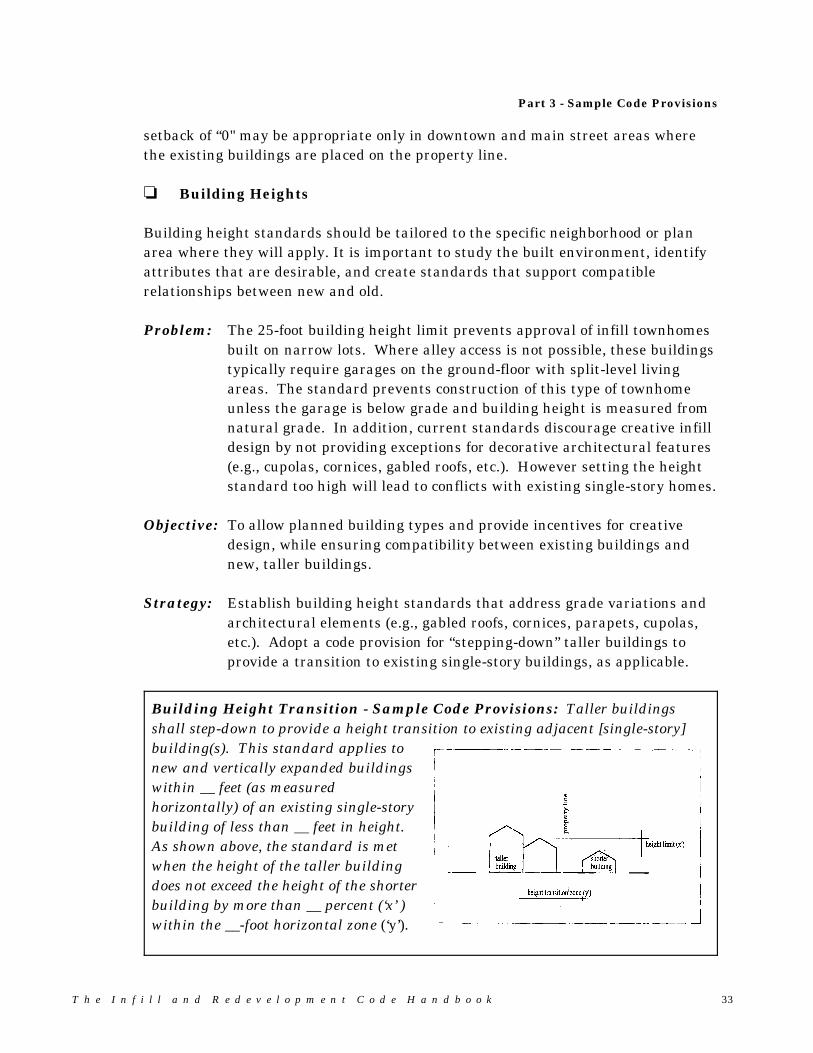
Building Height Transition - Sample Code Provisions: Taller buildingsshall step-down to provide a height transition to existing adjacent [single-story]building(s). This standard applies tonew and vertically expanded buildingswithin __ feet (as measuredhorizontally) of an existing single-storybuilding of less than __ feet in height. As shown above, the standard is metwhen the height of the taller buildingdoes not exceed the height of the shorterbuilding by more than __ percent (‘x’ )within the __-foot horizontal zone (‘y’).
3 4 T h e I n f i l l a n d R e d e v e l o p m e n t C o d e H a n d b o o k
� Street Frontage, Access and Circulation
One of the difficulties with infill development, and one of the reasons that infill parcels exist, is that the street system in these areas is often incomplete. Completing the street and sidewalk system through mid-block developments, flaglots, pedestrian accessways, and continuation of alleys and lanes, is one of thechallenges to communities who are trying to encourage infill.
Problem: Development standards do not allow mid-block developments (i.e., lotsfronting off of a private lane) and flag lots. All lots in Happy HollowNeighborhood must have frontage onto a public street with a minimumof 60 feet of right-of-way. In many areas, lots and parcels havestandard widths but are deep; essentially unused space at the backs ofthese lots provides room for infill housing.
Objective: To encourage infill development by providing alternatives to publicstreet frontage requirements.
Strategy: Adopt code provisions enabling mid-block developments and flag lots,giving first priority to the creation of new streets or lanes.
Mid-Block Developments and Flag Lots - Sample Code Provisions
1. Mid-block lanes. When frontage onto a public street cannot be provided for anew land division, lots may receive access from mid-block lanes, as shown inFigure __ (next page). Mid-block lanes shall be required, wheneverpracticable, as an alternative to approving flag lots.
2. Flag lots. Flag lots may be created only when mid-block lanes cannot beextended to serve future development (See Figure X.) A flag lot driveway mayserve no more than two (2) dwelling units, including accessory dwellings anddwellings on individual lots, unless Uniform Fire Code (UFC) standards aremet for more units. When UFC standards are met, the maximum number ofdwellings shall be six (6). A drive serving more than one lot shall have areciprocal access and maintenance easement recorded for all lots it serves. No fence, structure or other obstacle shall be placed within the drive area.
(Continued)

Part 3 - Sample Code Provisions
T h e I n f i l l a n d R e d e v e l o p m e n t C o d e H a n d b o o k 35
Mid-Block Developments and Flag Lots - Sample Code Provisions
3. Driveway and lane width. The minimum width of allshared drives and lanesshall be [12] feet; themaximum width is [20]feet, except as required bythe Uniform Fire Code.
4. Maximum drive lanelength. The maximumdrive lane length is subjectto requirements of theUniform Fire Code, butshall not exceed [150] feetfor a shared side drive,and [400] feet for a sharedrear lane.
5. Drive lane ownership andmaintenance. [20 feet ofright-of-way / a 20- footeasement (i.e., 10 feet fromeach property sharing adrive)] shall be providedfor vehicle access similarto an alley and shallconform to the Uniform Fire Code. The [right-of-way dedication / easement]shall be required at the time of partition or subdivision plat approval, andshall be recorded on the plat.
6. Future street plans. Building placement and alignment of shared drivesshall be designed so that future street connections can be made assurrounding properties develop (i.e., as shown above).

3 6 T h e I n f i l l a n d R e d e v e l o p m e n t C o d e H a n d b o o k
� Residential Density Standards
Problem: Conventional density standards, such as minimum/maximum lot sizeand units per “gross acre”, are often unworkable or counterproductivefor two reasons:1. Physical constraints, such as odd-shaped parcels, steep slopes and
natural resource constraints prevent standard or uniform lot sizes;and
2. Flexibility in building design and housing types is often necessary tomake infill and redevelopment projects economically feasible.
Objective: To provide alternatives to rigid lot area and density standards thatconform to the Comprehensive Plan.
Strategy: Allow lot size averaging and density transfers, and use density bonusesto encourage creative design and neighborhood-friendly development.
Residential Density Standards - Sample Code Provisions
1. Minimum Density. When lots are created through a partition or subdivision,or site development is proposed for two or more dwelling units, a minimumdensity of 80 percent of the maximum density permitted by the zone isrequired, except that this standard does not apply to the followingdevelopments:a. Partitions of parcels totaling 20,000 square feet or less;b. Lot line adjustments; andc. Development on physically constrained sites, where lot configuration,
access limitations, topography, significant trees, wetlands or othernatural features prevent development at the minimum density.
d. Phased developments, where a “shadow plan” is provided which showsfuture intensification of the site, in conformance with the minimumdensity standard. Shadow plans shall demonstrate the ability toreasonably divide oversized lots in the future, and provide for plannedstreet and utility connections.
The number of lots or dwelling units required shall be determined bymultiplying the maximum density permitted by the zone, exclusive ofpotential density bonuses, by 0.8. The result shall be rounded up for anyproduct with a decimal of 0.5 or greater and rounded down for any productwith a decimal less than 0.5.
Continued...
Part 3 - Sample Code Provisions
T h e I n f i l l a n d R e d e v e l o p m e n t C o d e H a n d b o o k 37
Residential Density Standards - Sample Code Provisions (continued)
2. Lot Size Averaging. Except as allowed through a planned unit development,new partitions and subdivisions shall achieve the following lot areas:- R-3 (attached/detached single family) zone - average lot area between3,000-4,000 square feet. Minimum lot area is 2,000 - square feet;- R-5 (detached single family) zone - average lot area between 5,000-6,000square feet. Minimum lot area is 4,000 square feet;- R-7.5 (detached single family) zone- average lot area between 7,500-9,000square feet. Minimum lot area is 6,000 square feet.
Discussion: These standards can be provided citywide “by definition”, orthey can be limited to specific zone districts. They are intended to provide amore flexible alternative to minimum lot size standards (e.g., 3,000 sq ft,5,000 sq ft, and 7,500 sq ft.
3. Density Bonus. A density bonus may be granted up to a total of [10-20]percent of the base density for the provision of the following public benefits:a. Dedication of public park, greenway, plaza or similar public space;b. Provision of affordable housing, as defined by Section __;c. Provision of public services (e.g., community center, library branch, etc.);d. [other]
Discussion: The residential density standards must be consistent with theComprehensive Plan. The plan may need to be amended to allow densitybonuses.
4. Density Transfer. A density transfer is an equal transfer of allowabledwelling units from one portion of the site to another. Density transfers areallowed by right for the following areas (i.e., transfer density ‘from’):a. Area within the floodway and the floodway fringe;b. Area over __ percent slope;c. Known landslide areas or areas shown to have potential for severe or
moderate landslide hazard (e.g., on Department of Geology and MineralIndustries maps);
d. Area in designated streams, wetlands and natural areas and theirassociated buffers;
e. Areas constrained by monitoring wells and similar areas dedicated toremediation of contaminated soils or ground water; and
f. Areas similar to those in a-e above, as approved by the Planning Director,and subject to public notice for Type II Administrative Decisions.
3 8 T h e I n f i l l a n d R e d e v e l o p m e n t C o d e H a n d b o o k
� Residential Building Size
Problem: One of the chief complaints about infill housing in our community isthat it is out of scale with established residences. For example, adeveloper partitions a 10,000 square foot parcel (located mid-block)into two 5,000 square foot lots. The lots are similar in size and shapeto the neighboring lots, but the developer’s houses dwarf every houseon the block. The houses have large garages, very little yard space,and windows that look down into the yards of adjoining residences. This situation points to several design problems; one of the keyproblems relates to the bulk and mass of structures.
Objective: To control the size of residential structures as related to lot size.
Strategy: Control the bulk of infill housing and make it more compatible withestablished residences by using a graduated scale, or “floor arearatio”, that relates building size to lot size:
Residential Building Size - Sample Code Provisions:
1. Residential Floor Area Standards. In order to implement the residentialbuilding intensity policies of the Happy Hollow Neighborhood Plan and limitthe mass of residential buildings in relation to the lot area, residential floorarea shall not exceed:a. 60 percent of the effective lot area on lots with less than 4,000 square feet.
“Effective lot area is the gross horizontal area of a lot minus any portion ofthe lot encumbered by a recorded driveway or roadway easement; and
b. 2,000 square feet plus 10 percent of the effective lot area on lots with 4,000to 10,000 square feet.
2. Existing Development. Existing development may be remodeled and expandedup to the floor area limits provided in subsection 1.
3. Residential Floor Area Defined. As used in this section, “floor area” is the sumof the gross horizontal areas of all floors of all principal and accessorybuildings measured from the exterior faces of the exterior walls of thebuilding(s), and all other enclosed volumes which could be utilized as floor areaand have minimum dimensions of 8 feet by 10 feet and 7 ½ feet head room,without additional excavation. Floor area excludes all unenclosed horizontalsurfaces such as balconies, decks or porches; the first 400 square feet of garagespace; the first 400 square feet of any accessory dwelling; and any areas belowor predominately below both the natural and finished grade, measured at theperimeter of the building, which in the opinion of the Director of Planning doesnot add to the visual mass of the building. Interpretations of this section madeby the Director may be appealed to the Planning Commission (Chapter __).
Part 3 - Sample Code Provisions
T h e I n f i l l a n d R e d e v e l o p m e n t C o d e H a n d b o o k 39
Discussion:The residential floor area standards in the sample code should be tailored to fit thelocal design context and housing needs of your community. The intent of the code isto provide a graduated scale based on lot area and the size of existing residences inthe neighborhood.
� Commercial Floor Area
Problem: The City is not meeting its development targets for downtown. Toomuch land is being developed with single-story buildings and vastareas are being converted into surface parking lots. There is concernthat the market may respond negatively to mandates for multi-levelbuildings.
Objective: To require more efficient use of land in the downtown and provideincentives for higher-intensity development (i.e., to improve the retailshopping environment).
Strategy: Establish minimum floor area standards that allow flexibility forgradual implementation. Floor area standards should be set highenough to achieve infill and redevelopment objectives. The standardshould also be consistent with the development scale of thecommunity and the building height standards of the applicable zonedistrict. Consider providing incentives for mixed use developmentand structured parking by exempting those uses from floor arearequirements in commercial zones.
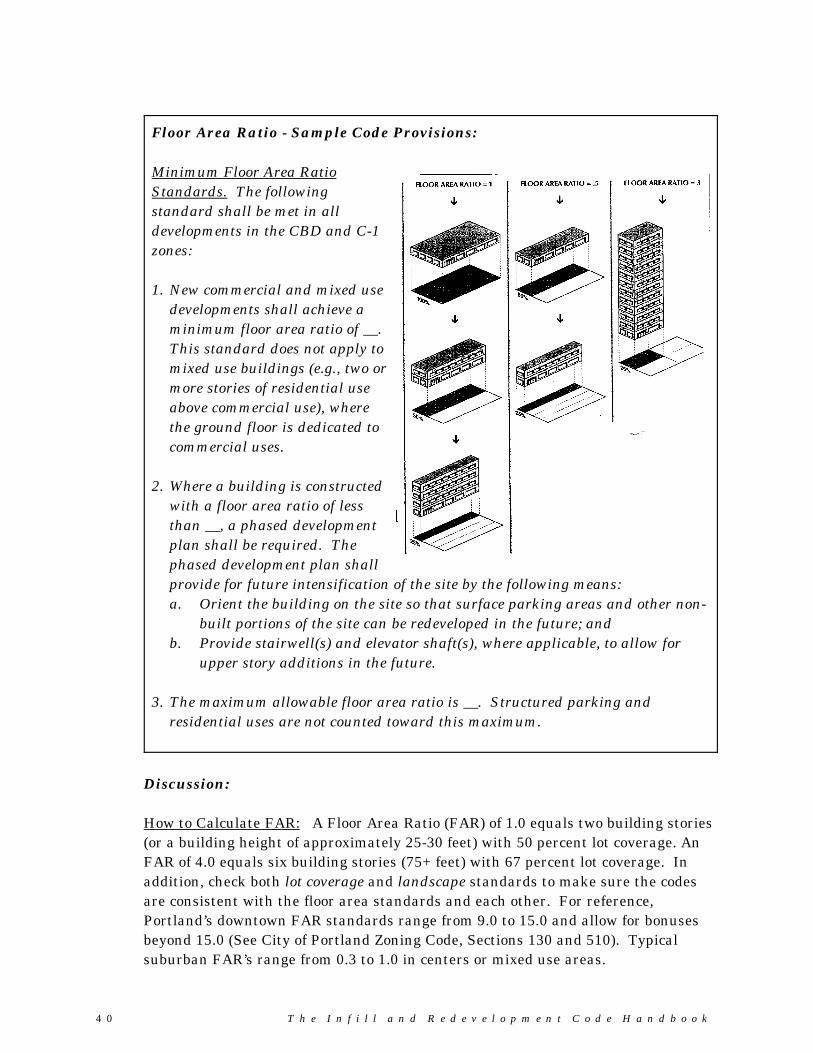
4 0 T h e I n f i l l a n d R e d e v e l o p m e n t C o d e H a n d b o o k
Floor Area Ratio - Sample Code Provisions:
Minimum Floor Area RatioStandards. The followingstandard shall be met in alldevelopments in the CBD and C-1zones:
1. New commercial and mixed usedevelopments shall achieve aminimum floor area ratio of __. This standard does not apply tomixed use buildings (e.g., two ormore stories of residential useabove commercial use), wherethe ground floor is dedicated tocommercial uses.
2. Where a building is constructedwith a floor area ratio of lessthan __, a phased developmentplan shall be required. Thephased development plan shall provide for future intensification of the site by the following means:a. Orient the building on the site so that surface parking areas and other non-
built portions of the site can be redeveloped in the future; andb. Provide stairwell(s) and elevator shaft(s), where applicable, to allow for
upper story additions in the future.
3. The maximum allowable floor area ratio is __. Structured parking andresidential uses are not counted toward this maximum.
Discussion: How to Calculate FAR: A Floor Area Ratio (FAR) of 1.0 equals two building stories(or a building height of approximately 25-30 feet) with 50 percent lot coverage. AnFAR of 4.0 equals six building stories (75+ feet) with 67 percent lot coverage. Inaddition, check both lot coverage and landscape standards to make sure the codesare consistent with the floor area standards and each other. For reference,Portland’s downtown FAR standards range from 9.0 to 15.0 and allow for bonusesbeyond 15.0 (See City of Portland Zoning Code, Sections 130 and 510). Typicalsuburban FAR’s range from 0.3 to 1.0 in centers or mixed use areas.
Part 3 - Sample Code Provisions
T h e I n f i l l a n d R e d e v e l o p m e n t C o d e H a n d b o o k 41
� Building and Site Design
Problem: Some of the our city’s design standards are overly prescriptive. Sincewe cannot anticipate all of the design challenges (and loopholes) thatdevelopers encounter, the standards tend to be unworkable for smallinfill projects. This is one reason why so many variances arerequested for small developments and building additions inneighborhoods that are close to being built-out. At the same time,residents who have been disappointed by the design of newdevelopments in their neighborhood are demanding a higher standardfor design. These conflicting interests (flexibility versus certainty)pose significant challenges to the developers, architects, planners,engineers and local government officials who are responsible fordesigning and reviewing infill and redevelopment projects in our city. Most of the problems relate to the following design elements:- Building Orientation- Residential Open Space- Landscaping- Parking- Building Design- Safety and Security
Objective: To provide infill design standards that afford greater certainty todevelopers and neighbors, and provide procedural flexibility.
Strategy: Provide more flexible procedures, for example, by allowing developersto choose from a two-track system of clear and objective (Type I)standards and discretionary/performance-based (Type II or III)standards for design. As an option to developers, the tracks allow forincreased procedural flexibility. Providing clear and objectivestandards as a “safe harbor” also ensures consistency with ORS197.307, which addresses appearance and aesthetic standards forneeded housing. The following provides more detailedrecommendations for each of the design elements listed under theproblem statement:
4 2 T h e I n f i l l a n d R e d e v e l o p m e n t C o d e H a n d b o o k
� Building Orientation
Problem: City standards require buildings to be oriented to a public street. This is not always possible within Happy Hollow Neighborhood,where many infill sites have limited or no public street frontage.
Objective: To provide flexibility in building orientation standards, while meetingthe city’s goal to develop pedestrian-oriented neighborhoods andcommercial districts.
Strategy: Allow buildings oriented to private streets that meet pedestrian-oriented standards (e.g., sidewalks, trees, lighting, etc.), and requirepedestrian connections to adjacent public streets.
Building Orientation - Sample Code Provisions
All buildings within the Happy Hollow (HH) zone shall be oriented to a publicstreet,, except when buildings cannot be oriented to the street due to inadequatestreet frontage. In this case, buildings may be oriented to a private streets or lane,which shall be developed in conformance with city standards for pedestriancirculation.
Part 3 - Sample Code Provisions
T h e I n f i l l a n d R e d e v e l o p m e n t C o d e H a n d b o o k 43
� Residential Open Space
Problem: The City requires a flat percentage of common open space for everymultiple family development. The percentage is not practical forsmall infill sites because it does not yield enough open space to beusable or desirable due to inadequate area, dimensions or siteconditions (e.g., slope, adjacent to street, etc.).
Objective: To provide flexibility in open space requirements, including regulatoryrelief for small developments.
Strategy: Allow private open space, such as balconies and patios, to substitutefor common open space. Provide open space “credit” for multiplefamily projects located close to a park. Exempt the smallestdevelopments (e.g., less than four dwelling units) from open spacerequirements.
Open Space Standard - Sample Code Provisions
Discretionary Standard:Multiple family developments shall provide adequate private and common openspace areas for residents. Private open spaces such as balconies, patios andsimilar spaces shall be oriented to household use, and provide sufficient space forthe enjoyment of the occupants. Common open spaces, such as courtyards, playareas, outdoor recreation facilities and similar spaces shall be sufficient in sizeand function for the enjoyment of all occupants of the development.
Clear and Objective Standard:Multiple family developments shall provide common open space (e.g., courtyards,play areas, outdoor recreation facilities and/or similar space) that is equal to orgreater than __ percent of the development site, except as follows:
1. Exemption for Small Developments. Developments of __ or fewer dwelling unitsare exempt from this standard.
2. Credit for Private Open Space. Up to __ percent of the open space standard maybe met by providing private open space, such as balconies, porches and patios.
3. Credit for Proximity to a Park. An open space credit of __ percent may begranted when a multiple family development is connected to an improved publicpark located within one-quarter mile, by a continuous sidewalk meetingAmericans with Disability Act (ADA) standards.
4 4 T h e I n f i l l a n d R e d e v e l o p m e n t C o d e H a n d b o o k
� Landscaping
Problem: The City requires a flat percentages and other very prescriptivelandscape standards (e.g., 20 percent of site and 8 percent of interiorparking areas ... one tree per 30 lineal feet ... evenly distributedlandscape plant materials, etc.) These standards are excessive andunworkable for some infill sites. For example, small parcels of lessthan one acre may not be developable at planned densities aftersubtracting required landscape areas. Other parcels may yieldenough landscaping to meet the standards, but the result — the use ofodd remnant spaces to comply — is not desirable. Inadequate area,dimensions and site conditions (e.g., exposure, slope, interferencewith structures, etc.) can result in poor landscape designs and plantsthat are difficult to maintain.
Objective: To provide flexibility in landscaping requirements, includingregulatory relief for small developments.
Strategy: See the sample code language, below:
Landscape Standard - Sample Code Provisions
Discretionary Standard:Multiple family developments shall provide landscaping which, in total,accomplishes the following objectives: Shading of parking areas and walkways;ground cover predominately consisting of planted materials or usable hardscapefeatures such as seating, plazas or similar areas; erosion control; and attractivestreetscapes and common areas.
Clear and Objective Standard:All areas not developed with structures, driveways, parking lots, private streets,pathways, patios, and similar usable areas shall be landscaped. Parking areaswith more than two rows of parking stalls shall be broken up by landscaping intogroups of no more than __ consecutive parking spaces (i.e., using landscapeislands, planters, or other landscape areas).
Part 3 - Sample Code Provisions
T h e I n f i l l a n d R e d e v e l o p m e n t C o d e H a n d b o o k 45
� Parking
Problem: Historically, our community has required more parking than isnecessary for some land uses, wasting extensive areas of land thatcould be put to better use. Developers of infill and redevelopmentprojects often have to assemble properties under multiple ownershipsin order to meet parking requirements that may be set too high. Thisincreases the cost to develop and is a disincentive for small infill andredevelopment projects. Similarly, parking “demand” can be aproblem due to the perception among some consumers that parking isinconvenient (or parking costs too much) in the downtown.
Objective: To reduce parking standards, where possible, and allow for moreefficient use of existing parking areas.
Strategy: Allow or even require shared parking, parking reductions (e.g., foravailable on-street parking, senior housing and access to transit) andmeasures designed to reduce parking demand (e.g., designated car/vanpool parking).
4 6 T h e I n f i l l a n d R e d e v e l o p m e n t C o d e H a n d b o o k
Parking Space Standards - Sample Code Provisions:
Combined Discretionary and Clear and Objective Standard:The number of required off-street parking spaces shall be based upon Table __ [this isthe city’s parking table], or an estimate of off-street parking needs prepared by theapplicant and subject to review and any refinements by the [city official / planningcommission]. The estimate of off-street parking needs shall be based on the followingmethod:1. Peak Use. First, estimate the peak use of the site in number of persons (e.g., based
on building capacity, number of bedrooms, or other objective measure).2. Person-Auto Trips. Second, estimate the number of persons requiring automobile
transport to the site (i.e., subtract likely transit/senior transit, bicycling, walkingand other types of trips). For example, [the City’s Transportation System Plan /recent ODOT data] indicates that approximately __ percent of all trips made in __County are by non-automobile modes of transportation. (Source:__ )
3. Auto Parking. Third, divide the number of persons requiring automobiletransport by a “car-pool” factor. For example, [the City’s Transportation SystemPlan / recent ODOT data] indicates that automobile in __ County carries anaverage of __ persons. (Source: __) The result is the number of automobilesrequiring on- and/or off-street parking.
4. On-Street Parking Credit. Fourth, subtract the number of on-street parking spacesavailable for the proposed use. The amount of off-street parking required shall bereduced by one off-street parking space for every on-street spaces in front of thedevelopment (i.e., on one side of the street). On-street parking shall follow theestablished configuration of existing on-street parking, except that angled parkingmay be allowed for some streets, where permitted by [City, ODOT and/or County]standards. The following constitutes an on-street parking space:a. Parallel parking, each [24] feet of uninterrupted curb;b. [45/60] degree diagonal, each with __ feet of curb;c. 90 degree (perpendicular) parking, each with __ feet of curb;d. Curb space must be contiguous to the lot which contains the use;e. Parking spaces may not be counted that would obstruct a required clear
vision area, nor any other parking that violates any law or street standard;and
f. On-street parking spaces credited for a specific use shall not be usedexclusively by that use, but shall be available for general public use at alltimes. No signs or actions limiting general public use of on-street spacesshall be permitted.
Part 3 - Sample Code Provisions
T h e I n f i l l a n d R e d e v e l o p m e n t C o d e H a n d b o o k 47
� Building Design
It is in a community’s best interest to accommodate growth in a manner that hasthe least negative impact on its existing neighborhoods. The compatibility of newbuildings may be enhanced by incorporating building styles and details common inthe neighborhood. For example, a building’s design should relate to surroundingbuildings in terms of scale, color, window orientation and proportions, and facadearticulation.
Buildings can be designed to reduce negative impacts on the neighborhood byorienting windows away from the private areas of nearby houses, stepping backbuilding bulk from property lines to allow more sunlight to surrounding lots, andusing building forms and materials that are consistent with the character ofbuildings nearby. Site design features, such as screening and landscaping, can alsohelp developments blend into the neighborhood.
Problem: Recent building designs on infill projects have not blended into theneighborhood. For example, new apartment buildings and rows oftownhomes have a “monolithic” appearance and do not reflect themore detailed design of older buildings. The development communityand neighbors have requested greater certainty in designrequirements, however, developers would also like to have flexibilityin design.
Objective: To establish design requirements that are tailored to theneighborhood and provide flexibility.
Strategy: Provide optional review tracks for both clear and objective anddiscretionary approvals. This approach also ensures compliance withORS 197.307, which addresses aesthetic and appearance standardsfor needed housing.
For an examples of two communities’ discretionary design guidelines,please refer to Appendix C (“City of Portland Community DesignGuidelines” and “City of Ashland Historic District DesignStandards”). For an example of clear and objective design standards,please refer to Appendix D (“City of Ashland Tolman Creek RoadNeighborhood Overlay Zone”).

4 8 T h e I n f i l l a n d R e d e v e l o p m e n t C o d e H a n d b o o k
� Safety and Security
More compact settlement patterns can lead to heightened concerns about crime andpersonal safety, particularly in fast-growing communities. This is evident in thepublic testimony that planning commissioners and city councilors often hear, forexample, when considering zone changes for increased housing density.
Problem: Recent infill developments have required protracted public hearings,and several projects have been appealed, due to concerns about publicsafety and security. Current city standards do not address importantsafety and security design elements.
Objective: To require design features that promote safety and security.
Strategy: Adopt standards and/or guidelines for “Crime Prevention ThroughEnvironmental Design” (CPTED). Public safety and designprofessionals have come to recognize the value of the followingCPTED principles in new developments, which can be implementedthrough zone district standards and/or design review standards:
Territoriality - People protect and maintain territory that theyfeel is their own and have a certain respect for the territory ofothers. Fences, pavement treatments, art, signs, andlandscaping are some physical ways to express ownershipthrough design.
Natural surveillance - Placing physical features, activities, andpeople in ways that maximize the ability to see what’s going ondiscourages crime. Window placement, the use of frontporches, and standards for landscaping and lighting canpromote natural surveillance.
Activity support - Encouraging legitimate activity in publicspaces helps discourage crime. Site layout and design featurescan help to facilitate recreation, socializing, civic events, etc. For example, open space standards for multiple family housingcan require centrally located play areas for children where aclear line of sight is provided from dwellings.
Access control - Properly located entrances, exits, fencing,landscaping, and lighting can direct both foot and automobiletraffic in ways that discourage crime. Access control can be assimple as a neighbor on a front porch or a front office. (Forexample, gated developments should be prohibited becausethey conflict with streetscape and natural surveillanceobjectives.)
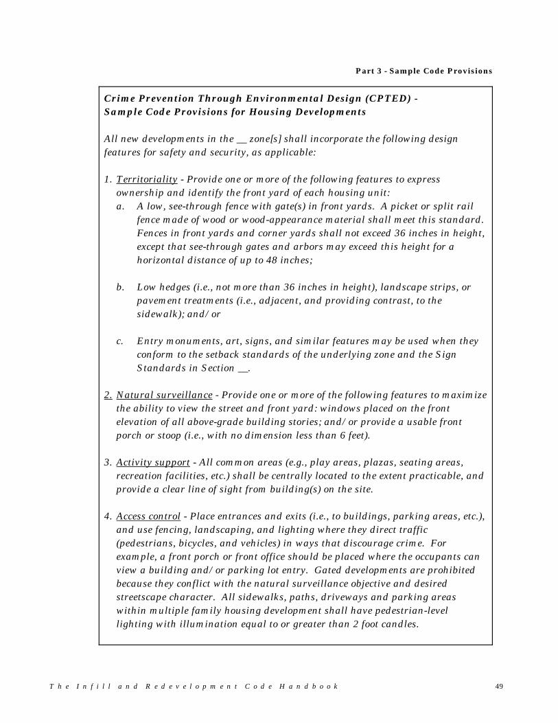
Part 3 - Sample Code Provisions
T h e I n f i l l a n d R e d e v e l o p m e n t C o d e H a n d b o o k 49
Crime Prevention Through Environmental Design (CPTED) -Sample Code Provisions for Housing Developments
All new developments in the __ zone[s] shall incorporate the following designfeatures for safety and security, as applicable:
1. Territoriality - Provide one or more of the following features to expressownership and identify the front yard of each housing unit:a. A low, see-through fence with gate(s) in front yards. A picket or split rail
fence made of wood or wood-appearance material shall meet this standard. Fences in front yards and corner yards shall not exceed 36 inches in height,except that see-through gates and arbors may exceed this height for ahorizontal distance of up to 48 inches;
b. Low hedges (i.e., not more than 36 inches in height), landscape strips, orpavement treatments (i.e., adjacent, and providing contrast, to thesidewalk); and/or
c. Entry monuments, art, signs, and similar features may be used when theyconform to the setback standards of the underlying zone and the SignStandards in Section __.
2. Natural surveillance - Provide one or more of the following features to maximizethe ability to view the street and front yard: windows placed on the frontelevation of all above-grade building stories; and/or provide a usable frontporch or stoop (i.e., with no dimension less than 6 feet).
3. Activity support - All common areas (e.g., play areas, plazas, seating areas,recreation facilities, etc.) shall be centrally located to the extent practicable, andprovide a clear line of sight from building(s) on the site.
4. Access control - Place entrances and exits (i.e., to buildings, parking areas, etc.),and use fencing, landscaping, and lighting where they direct traffic(pedestrians, bicycles, and vehicles) in ways that discourage crime. Forexample, a front porch or front office should be placed where the occupants canview a building and/or parking lot entry. Gated developments are prohibitedbecause they conflict with the natural surveillance objective and desiredstreetscape character. All sidewalks, paths, driveways and parking areaswithin multiple family housing development shall have pedestrian-levellighting with illumination equal to or greater than 2 foot candles.
5 0 T h e I n f i l l a n d R e d e v e l o p m e n t C o d e H a n d b o o k
� Special Use Standards
Problem: The code does not provide standards for some types of neighborhood infill development that warrant special standards (e.g., townhomes,neighborhood commercial uses, accessory dwellings, mixed use, etc.). Without special standards in place, the city is unable to providecertainty to neighbors, and developers are discouraged from proposingcontroversial infill projects.
Objective: To promote infill development in Happy Hollow by establishingstandards that are tailored to specific types of land use in theneighborhood.
Strategy: Establish “Special Use” standards for attached housing (e.g.,duplexes, triplexes, zero-lot line housing), accessory dwellings,neighborhood commercial development, and mixed use in HappyHollow Neighborhood.

Part 3 - Sample Code Provisions
T h e I n f i l l a n d R e d e v e l o p m e n t C o d e H a n d b o o k 51
Special Use Standards - Sample Code Provisions
1. Duplexes, Triplexes, and Attached Single Family (Townhome) Dwellings in theHappy Hollow (HH) zone.
Duplexes, triplexes and townhomes (not to exceed 4 consecutively attached units)are permitted in the HH zone, subject to all of the following standards:a. Duplexes, triplexes, and townhome buildings comprising [2,000-2,800] square
feet of living area in total (i.e., exclusive of garage and crawl space), or less, arepermitted on any HH lot.
b. Duplexes, triplexes and townhome buildings comprising more than __ squarefeet of living area are permitted on corner lots only.
c. The maximum width of a street-facing garage shall not exceed 24 feet (i.e., twosingle or one double car garage) per building on any single street frontage. Thisstandard shall not apply to garages accessed from an alley.
d. All duplex, triplex, and townhome buildings shall comply with the applicablesetback standards and building design standards in Sections __.
____________________________________________________________________________
Discussion: These standards should be tailored to fit the local context. Forexample, the threshold for permitting duplexes and smalltownhome buildings on any lot should be based on the size of singlefamily houses in that particular neighborhood. For example, ifhouses are large enough to potentially accommodate duplexconversion (e.g., greater than 2,000-2,800 square feet, as suggestedin the example), that can indicate whether new duplexes would becompatible with the neighboring single family houses. Even ifconversions are unlikely, the size of existing residences can indicatewhether new duplexes would be compatible. The 2,000-2,800square foot threshold is suggested only as an example. Actualbuilding sizes will vary, and the standards should be based on localhousing needs and compatibility with existing residences.
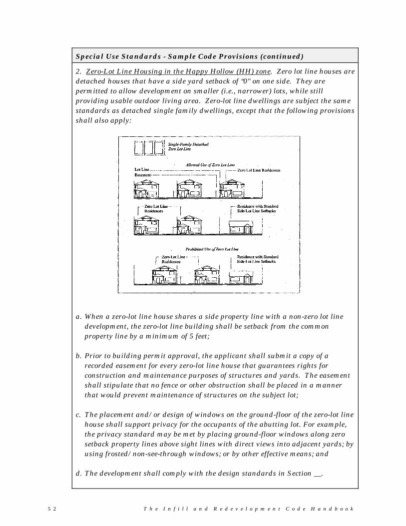
5 2 T h e I n f i l l a n d R e d e v e l o p m e n t C o d e H a n d b o o k
Special Use Standards - Sample Code Provisions (continued)
2. Zero-Lot Line Housing in the Happy Hollow (HH) zone. Zero lot line houses aredetached houses that have a side yard setback of “0" on one side. They arepermitted to allow development on smaller (i.e., narrower) lots, while stillproviding usable outdoor living area. Zero-lot line dwellings are subject the samestandards as detached single family dwellings, except that the following provisionsshall also apply:
a. When a zero-lot line house shares a side property line with a non-zero lot linedevelopment, the zero-lot line building shall be setback from the commonproperty line by a minimum of 5 feet;
b. Prior to building permit approval, the applicant shall submit a copy of arecorded easement for every zero-lot line house that guarantees rights forconstruction and maintenance purposes of structures and yards. The easementshall stipulate that no fence or other obstruction shall be placed in a mannerthat would prevent maintenance of structures on the subject lot;
c. The placement and/or design of windows on the ground-floor of the zero-lot linehouse shall support privacy for the occupants of the abutting lot. For example,the privacy standard may be met by placing ground-floor windows along zerosetback property lines above sight lines with direct views into adjacent yards; byusing frosted/non-see-through windows; or by other effective means; and
d. The development shall comply with the design standards in Section __.
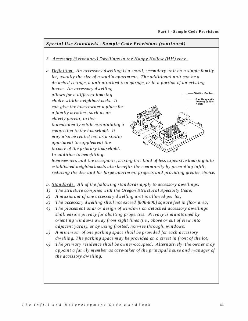
Part 3 - Sample Code Provisions
T h e I n f i l l a n d R e d e v e l o p m e n t C o d e H a n d b o o k 53
Special Use Standards - Sample Code Provisions (continued)
3. Accessory (Secondary) Dwellings in the Happy Hollow (HH) zone .
a. Definition. An accessory dwelling is a small, secondary unit on a single familylot, usually the size of a studio apartment. The additional unit can be adetached cottage, a unit attached to a garage, or in a portion of an existinghouse. An accessory dwellingallows for a different housingchoice within neighborhoods. Itcan give the homeowner a place fora family member, such as anelderly parent, to liveindependently while maintaining aconnection to the household. Itmay also be rented out as a studioapartment to supplement theincome of the primary household. In addition to benefittinghomeowners and the occupants, mixing this kind of less expensive housing intoestablished neighborhoods also benefits the community by promoting infill,reducing the demand for large apartment projects and providing greater choice.
b. Standards. All of the following standards apply to accessory dwellings:1) The structure complies with the Oregon Structural Specialty Code;2) A maximum of one accessory dwelling unit is allowed per lot;3) The accessory dwelling shall not exceed [600-800] square feet in floor area;4) The placement and/or design of windows on detached accessory dwellings
shall ensure privacy for abutting properties. Privacy is maintained byorienting windows away from sight lines (i.e., above or out of view intoadjacent yards), or by using frosted, non-see through, windows;
5) A minimum of one parking space shall be provided for each accessorydwelling. The parking space may be provided on a street in front of the lot;
6) The primary residence shall be owner-occupied. Alternatively, the owner mayappoint a family member as care-taker of the principal house and manager ofthe accessory dwelling.
5 4 T h e I n f i l l a n d R e d e v e l o p m e n t C o d e H a n d b o o k
Special Use Standards - Sample Code Provisions (continued)
4. Neighborhood Commercial uses within the Happy Hollow (HH) zone. Small-scale commercial and mixed use development (e.g., a small market, dry cleaner,repair shop, etc., possibly with an apartment above) are allowed, subject to specialstandards. These uses combine more activities together in the same area and putsservices closer to where people live. Combining housing with other uses alsoincreases neighborhood safety by maintaining activity in a residential areasduring the day. A small business, such as a cafe or corner store, can add to thequality and convenience of the neighborhood. Neighborhood commercial usesshall comply with all of the following standards to ensure proper implementationof the Happy Hollow Neighborhood Plan:
a. Permitted Land Uses. The following uses are permitted where neighborhoodcommercial uses are permitted, except that an individual use shall not exceed[1,000 - 5,000] square feet in gross floor area.
1) Child Care Center2) Food services, excluding drive-through service3) Laundromats and dry cleaners4) Light manufacture (e.g., assembly of crafts and similar uses), conductedentirely within building5) Neighborhood market6) Medical and dental offices and clinics7) Personal services (e.g., barber shops, salons, similar uses)8) Professional and administrative offices9) Repair services, conducted entirely within building; except for auto-repairand similar uses10) Mixed use building (residential with other permitted use)11) Other uses similar to those listed in 1-9, above.
(Continued)
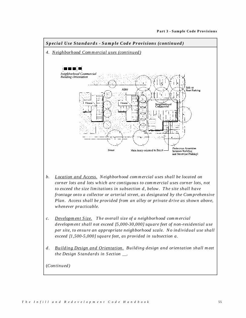
Part 3 - Sample Code Provisions
T h e I n f i l l a n d R e d e v e l o p m e n t C o d e H a n d b o o k 55
Special Use Standards - Sample Code Provisions (continued)
4. Neighborhood Commercial uses (continued)
b. Location and Access. Neighborhood commercial uses shall be located oncorner lots and lots which are contiguous to commercial uses corner lots, notto exceed the size limitations in subsection d, below. The site shall havefrontage onto a collector or arterial street, as designated by the ComprehensivePlan. Access shall be provided from an alley or private drive as shown above,whenever practicable.
c. Development Size. The overall size of a neighborhood commercialdevelopment shall not exceed [5,000-30,000] square feet of non-residential useper site, to ensure an appropriate neighborhood scale. No individual use shallexceed [1,500-5,000] square feet, as provided in subsection a.
d. Building Design and Orientation. Building design and orientation shall meetthe Design Standards in Section __.
(Continued)
5 6 T h e I n f i l l a n d R e d e v e l o p m e n t C o d e H a n d b o o k
Special Use Standards - Sample Code Provisions (continued)
4. Neighborhood Commercial uses (continued)
e. Hours of Operation. Neighborhood commercial land uses shall be limited tothe following hours of operation [6-7] a.m. to [9-10] p.m.
f. Parking Areas. The following vehicle parking standards shall be met:1) On-street parking shall be provided on at least one street adjacent to the
main building entry, except where otherwise prohibited by city standards. On-street parking spaces shall be credited toward the minimum parkingrequirement;
2) All off-street parking areas (e.g., lots, garages, driveways, etc.) shall beoriented to a side- or rear-yard, or placed in a garage (e.g., underground);
3) Parking areas on adjoining neighborhood commercial lots shall beconnected, whenever practicable;
4) Parking shall not be located between a street right-of-way and primary (i.e.,public or customer) building entrance.
5) Parking requirements shall be based on a parking needs study prepared bythe applicant, and subject to review and approval by the review authority.At a minimum, the following parking shall be provided:
- One parking space for every [500-1000] square feet of office space;- One parking space for every [300-500] square feet of retail;- One parking space for every [200-300] square feet of food servicespace, plus one space for every [2-3] employees during the largest shift;
6) Off-street parking areas shall not exceed a total of __ parking spaces foreach commercial use.
g. Other Standards. Neighborhood Commercial developments shall comply withall of the applicable setback and design standards in Sections __.
____________________________________________________________________________
Discussion: The ranges provided above for size of use, development size, hoursof operation and parking should be tailored to fit local conditions. For example, a 5,000 square foot use may correspond to aneighborhood market, whereas 30,000 square feet of total space,without limitations on use size, could be a medium size grocerystore. The parking standards represent the low range of possiblestandards, assuming walkable neighborhoods. The performancestandard in subsection 5 allows the jurisdiction to adjust theparking requirements. The maximum parking area size in “6"should be based on the desired character and scale of development. For example, a 3,000 square foot neighborhood retail center mightrequire 6-10 spaces, depending on availability of on-street parking.

Part 3 - Sample Code Provisions
T h e I n f i l l a n d R e d e v e l o p m e n t C o d e H a n d b o o k 57
Special Use Standards - Sample Code Provisions (continued)
5. Mixed Use Developments within the Happy Hollow (HH) zone. Mixed usedevelopments are allowed within the HH zone, subject to special standards. Forthe purpose of this example, “mixed use” means the combining of housing withnon-residential use(s). These uses may be mixed “vertically”, for example bybuilding apartments above ground-floor commercial space; or “horizontally”, bybuilding townhomes or apartments adjacent to commercial space. Mixed usedevelopments shall comply with all of the following standards to ensure properimplementation of the Happy Hollow Neighborhood Plan:
a. Mixed uses shall conform to the standards for Neighborhood Commercial uses,as provided in Section 4;
b. Residential uses shall not exceed the maximum density permitted by the HHzone;
c. The maximum building height may be increased by 10 feet as an incentive forvertical mixed use buildings, except where adjacent to single-story residentialuses.
d. Existing residential buildings may be redeveloped with a mix of uses (e.g.,living space above artist studio, retail, office, or other permitted use, subject tothe standards in a-c, above.

5 8 T h e I n f i l l a n d R e d e v e l o p m e n t C o d e H a n d b o o k
� Application Requirements and Review Procedures
Developers of infill and redevelopment sites face a myriad of physical, regulatory,and economic obstacles. Projects that meet the community’s vision and the reality ofthe marketplace often require lengthy and uncertain review procedures, variances,and even litigation over interpretations of land use standards. The following codeconcepts address some of the more common procedural obstacles to infilldevelopment:
� Before Submitting an Application
Problem: Developers of infill projects include private land owners, developmentcompanies, public agencies, home builders and many other entities withvarying levels of development experience. Local planners and engineersoften need to provide extra assistance to infill developers if they areunfamiliar with or lack development experience in our community.
Objective: To provide better information about application requirements earlierin the development review process.
Strategy: Preapplication conferences should be required. While the bestdevelopers will ask for these meetings without being told to do so, otherswill invest in their project without having done their due diligence withthe neighborhood. For this reason, preapplication conferences should berequired by code. These meetings between the applicant and city staffwill be most helpful if they result in a list of approval criteria, suggestedplan/design concepts or changes, and a clear description of the permitprocess with an estimated timeline for final approval. Please refer tothe sample code provision on the following page.
Neighborhood meetings. Successful infill developers routinely meet withneighborhoods to gather input on their ideas before finalizing plans andsubmitting applications. When an official neighborhood association doesnot exist, the developer can voluntarily organize a neighborhood meeting. Consider adopting procedures for advertising, conducting and recordingmeetings, while making sure that the procedures are not onerous (i.e.,remember that a developer is not required to make any changes based onneighbors’ comments). Code requirements should focus on ensuringproper notification of meetings. Most experienced developers will takemeeting notes and share them with the neighborhood association, anyway,whether or not they are required to do so.
Developer’s guide. Consider preparing a brief guide book or brochure forinfill and redevelopment projects. For example, the guide should provideanswers to “Frequently Asked Questions”, contact information for permit
Part 3 - Sample Code Provisions
T h e I n f i l l a n d R e d e v e l o p m e n t C o d e H a n d b o o k 59
agencies and neighborhood associations, and project checklists forapplicants.
Preapplication Conferences - Sample Code Provisions:
Preapplication Conference Required. Prior to submitting an application for[partition, subdivision, design review, site plan review, conditional use permit,variance, etc.] approval, the applicant shall request a “preapplication conference”(meeting). The meeting request shall be made on a form available at the PlanningDepartment and be accompanied by a sketch plan of the proposed development. The Planning Director or his/her designee shall distribute the request to other[city/county] as appropriate for their review and comments. The meeting shalltake place within [7-10] calendar days of the request, and result in the followinginformation being provided in writing to the applicant: list of approval criteria and standards; any suggested modifications to the plan or design; a clear outline of the permit process (this can be a standard handout); and an estimated timeline for final approval (i.e., excluding any appeals). This
estimate shall be contingent upon the applicant submitting a completeapplication.
Other information relevant to the proposed development or requested by theapplicant.
6 0 T h e I n f i l l a n d R e d e v e l o p m e n t C o d e H a n d b o o k
� The Application
Development applications typically include application forms, a fee, full size plansheets (e.g., 24"x36"), reduced plan sheets (e.g., 8.5"x11" or 11"x17"), and a writtennarrative responding to development code approval criteria. Subdivisions andcomplex site developments also usually require engineered plans, studies andcertifications from technical specialists. The cost and timing of these requirementscan discourage infill developers. For example, if the developer has an option to buyan infill property and that option is contingent upon receiving conditional usepermit approval, he/she is not likely to invest in a lot of engineering to gain thatapproval (i.e., as compared to preliminary plat approval). If the cost of applying(and risk of denial) is too great in relation to the total cost of the project, thedeveloper will back out of the project. Therefore, it is important to try andstreamline these requirements whenever possible for infill and redevelopmentprojects.
Problem: The high cost and time involved in applying for land use approvaldiscourages infill and redevelopment.
Objective: To reduce the cost and time required for land use decisions, andprovide expedited approval of initial land use applications (e.g.,conditional use, zone change, partition, lot line adjustments, etc.) forinfill and redevelopment projects.
Strategy: Consider reducing application requirements for decisions that do notrequire all the bells and whistles. For example:
Require only the number of application packets that are needed forreview. If only the planning and engineering departments reviewminor partitions, then require only three copies of the application (onefor each department and one for the file);
Allow submittal of reduced-size plans (11"x17") for some small-scaleprojects, rather than requiring full-size plots (24"x36") for everyproject.
Consider exempting infill projects that fall below certain thresholdsfrom having to prepare the following types of expensive studies: noisestudy, drainage study, traffic impact analysis, etc. Provide “safeharbor” standards that support exempting projects from thesestudies.
Allow submittal of “sketch plans” in lieu of engineered site plans fornarrowly focused requests, such as conditional use permits,partitions, lot line adjustments, and minor modifications to approveddevelopment plans.
Part 3 - Sample Code Provisions
T h e I n f i l l a n d R e d e v e l o p m e n t C o d e H a n d b o o k 61
� The Completeness Check
Problem: Much of the delay in obtaining development approval often occursduring the City’s initial completeness check of applications. Small infilland redevelopment projects are penalized when they have to go throughthe same completeness check as larger projects (i.e., typically a 30-dayreview). Staff workload often creates these bottlenecks.
Objective: To reduce the time required for initial completeness checks for infilland redevelopment projects.
Strategy: Consider providing an accelerated completeness check for minor or allinfill and redevelopment projects (i.e., make them the priority forcompleteness checks, to be done before other types of applications).Create a checklist for review partitions, lot line adjustments, minorbuilding additions, etc. For these projects, consider providing a one-stop“completeness-check-with-approval” procedure.
� Review Procedures and Appeals
In general, development review procedures include interdepartmental coordination,public notice, hearings, and appeals. These procedures can be streamlined topromote infill and redevelopment.
Problems:
#1 Discretionary decision-making results in unpredictable decisions. Forexample, standards which refer to approval “by the city engineer/firechief/planning director, etc.” but do not provide criteria for such decisions, failto provide sufficient direction to decision makers, applicants and citizens.
Strategy: Provide a “two-track” system for design review that includes both adiscretionary criteria track and an objective criteria track, as issuggested in the previous sections of this handbook. The two optionsfor compliance — e.g., discretionary review by the planningcommission and “safe-harbor” standards reviewed administratively —can provide more certainty to the developer and the public of what isexpected from infill and redevelopment projects.
6 2 T h e I n f i l l a n d R e d e v e l o p m e n t C o d e H a n d b o o k
#2 Inefficient public hearings and review procedures result in delays,and increase public and private costs. The classic example arises whensurrounding property owners first learn of a development when they receivemailed notice of a public hearing. Because their comments hit the planningcommission and city/county staff cold, the hearing is continued.
Strategy: Authorize more administrative approvals without public hearings forthose decisions that do not require hearings under state law; andnotify adjacent property owners of application reviews prior tohearings, issuance of staff reports and decisions. City staff should beavailable to meet with concerned citizens, and communicate theirconcerns to the applicant so he/she can respond in a timely manner.
#3 Variance criteria are overly restrictive when applied to infillproperties. Often it is impossible to meet the test of a hardship “not beingself-inflicted”. For example, unique building designs, alleys, private streetsand other features that are appropriate for infill but prohibited by the code,may not meet variance criteria if the request is not related to “physicalconstraints arising from the land, etc.”. Traditional variance criteria do notprovide flexibility for these types of design features.
Strategy: Consider revising the approval criteria for some types of variances. For example, consider allowing adjustments to prescriptive designstandards (e.g., building and site dimensions) when the purpose of thecode section is met by alternative means. An adjustment allowsflexibility to standards when the overall purpose of the code section ismet, and may allow for an administrative staff decision instead of apublic hearing. Another option is to provide an “AdministrativeVariance” procedure for minor variances (e.g., “up to 20% variance tosetback, building height, and similar standards may be granted by thePlanning Director, subject to the public notice requirements of Section__”). Both procedures can help in streamlining variance procedures. Typically, they include notification of neighbors, a 10-14 day commentperiod, and issuance of a written decision with findings of fact. (Adjustments and administrative variances must be appealable to theplanning commission or other review body.)
Part 3 - Sample Code Provisions
T h e I n f i l l a n d R e d e v e l o p m e n t C o d e H a n d b o o k 63
#4 “De novo” hearing rules prolong the appeals process. “De novo” meansstarting new. De novo hearing rules require that the city council, forexample, to begin its hearing with a new record; thus, the planningcommission record is not considered by the council unless it is explicitlyentered into the council’s record. This often prolongs the appeals processbecause the public record established during months of planning commissionmeetings is suddenly nullified. The “new” testimony collected during the denovo hearing is often redundant and requires the applicant to rebut the sameobjections over and over again.
Strategy: Consider making all appeal hearings “on the record”, so that thesehearings are limited to the facts that have already been presented. This provides the benefit of continuity in applying city standards andstreamlines the hearings process.