the loess/paleosol record and the nature of the younger ...episode that is both relatively short,...
TRANSCRIPT
Geoarchaeology: An International Journal, Vol. 13, No. 8, 847–869 (1998)q 1998 John Wiley & Sons, Inc. CCC 0883-6353/98/080847-23
shortstandard
GEA(Wiley) RIGHT BATCH
The Loess/Paleosol Record and the
Nature of the Younger Dryas Climate in
Central China
David B. Madsen,1 Li Jingzen,2 Robert G. Elston,3 Xu Cheng,4
Robert L. Bettinger,3 Geng Kan,5 P. Jeff Brantingham,6 andZhong Kan7
1Environmental Sciences, Utah Geological Survey, P.O. Box 146100, Salt Lake
City, Utah 84114
2Ningxia Cultural Relics Bureau, No. 60 East Wenhua Street, Yinchuan,
Ningxia 75004, People’s Republic of China
3Department of Anthropology, University of California-Davis, Davis,
California 95616
4Ningxia Archaeological Association, West Pagoda Courtyard, Yinchuan,
Ningxia 75001, People’s Republic of China
5Department of Resource and Environmental Science, Beijing Normal
University, Bejing 100875, People’s Republic of China
6Department of Anthropology, University of Arizona, Tucson, Arizona 85721
7Ningxia Provincial Museum, West Pagoda Courtyard, Yinchuan, Ningxia
75001, People’s Republic of China
The use of latest Pleistocene-Holocene paleosols in defining Chinese climatic sequences isplagued by poor chronological controls caused primarily by the use of radiocarbon datesderived from bulk soil carbon. Dating of a post-glacial aeolian/paleosol sequence in the PigeonMountain basin of north-central China, using culturally deposited charcoal, support a widearray of other data suggesting the Younger Dryas was a period of cooler dryer conditionsmarked by wide-spread aeolian deposition. Periods of soil formation and higher lake levelsbracket this climatic event. Climatic variability immediately before, during and immediatelyafter the Younger Dryas interval is associated with rapid technological elaboration and in-novation in the production and use of chipped stone tools, and perhaps, ground stone. q 1998John Wiley & Sons, Inc.
INTRODUCTION
Chinese loess/paleosol sequences are frequently used as primary proxies for LateQuaternary climatic changes in the central Asian land mass (An et al., 1990, 1991;Forman, 1991; Heller and Liu, 1986; Liu, 1985; Liu et al., 1992; Maher and Thompson,
MADSEN ET AL.
848 VOL. 13, NO. 8
shortstandard
GEA(Wiley) LEFT BATCH
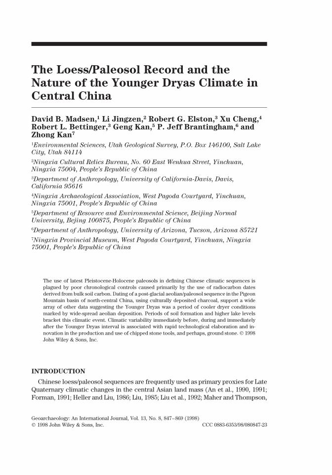
Figure 1. Location of primary loess/paleosol and lake-level sequences discussed in text.
1995; Rutter and Ding, 1993; Sun and Zhao, 1991; Winkler and Wang, 1993; Zhanget al., 1994). With very few exceptions, the paleosol horizons are interpreted asindicating warmer and more humid phases, while the less-weathered loess layersare consistently thought to represent cooler and drier phases (Maher and Thomp-son, 1995:383). The Baxie Paleosol (Figure 1), was once thought to have formed innorthwestern China during the Younger Dryas under cool but wet climatic condi-tions (An et al., 1993), but a broad array of evidence now suggests Younger Dryasclimates in central China were primarily cold and dry, consistent with other periodsof loess deposition, but were variable, with a brief interval of warmer/wetter con-ditions (Zhou et al., 1996).
We are interested in the influence of this climatic variability on hunting andgathering precursors of the Neolithic in northern China. This period is poorlyknown, but of increasing concern to scholars (Underhill, 1997). Available evidencesuggests a technological transition beginning in the Late Paleolithic, in which dis-coidal cores, flake points, blade tools, backed knives, and burins of the early LatePaleolithic (Shuidonggou: 26.2–17.2 ka) are supplanted by a more diverse array offlake and blade tools, developed unifacial and bifacial tools, microliths, and, per-haps, milling stones and partially ground celts in the latest Paleolithic (Xiachuan:

LOESS/PALEOSOL RECORD IN CENTRAL CHINA
GEOARCHAEOLOGY: AN INTERNATIONAL JOURNAL 849
shortstandard
GEA(Wiley) RIGHT BATCH
23.9–13.9 ka, Xueguan: 13.6 ka, and Hutouliang: 11.0 ka) (Chen, 1984; Zhou andHu, 1985; Ningxia Museum and Ningxia Bureau of Geology, 1987; Chen and Wang,1989; Yamanaka 1993). An early association of grinding stones, pestles, and redand gray ceramics occur in layer 6 of the Nanzhuangtou site, Hebei, dated at 10,8156 140 14C yr B.P. (BK87088) (Jin and Xu, 1992; Ren, 1995; Underhill, 1997: 114).
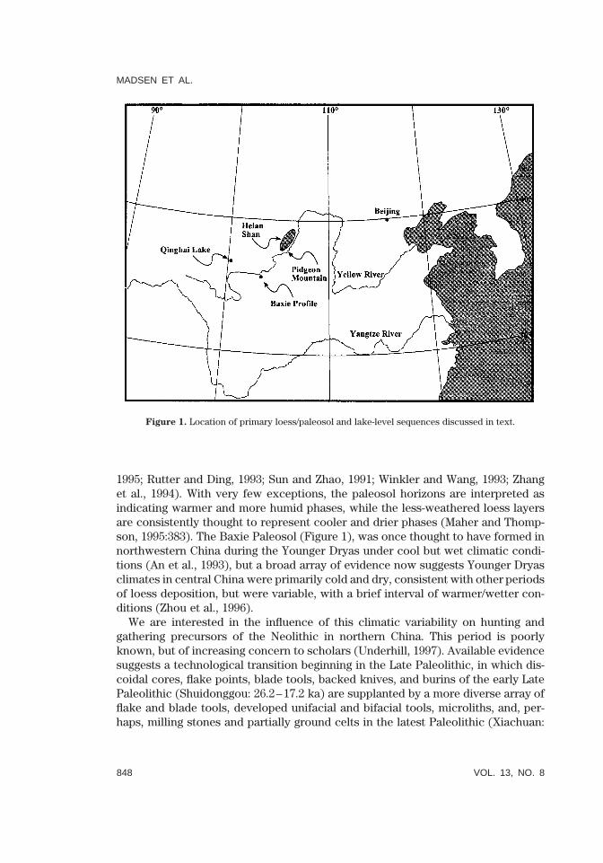
In 1990 the discovery of assemblages containing large cores, flake and bladetools, microliths, chipped and ground stone celts, and red and gray ceramics in thevicinity of (Pigeon Mountain) indicated the possibility of an important record ofculture change in the Late Paleolithic (Wang and Yu, 1996). Subsequent survey in1995/1996, conducted as part of an on-going study focused on the Helan Shan (He-lan Mountains) and adjoining desert areas of western Inner Mongolia and the Ni-ngxia Hui Autonomous Region (Bettinger et al., 1994; Madsen et al., 1996; Elstonet al., 1997), recorded ten archaeological sites in the Pigeon Mountain basin (Figure2). The Pigeon Mountain cluster includes QG3 (QG is the county designator withinNingxia), south of Pigeon Mountain, as well as QG4, QG5, QG6, and QG13. Twoother sites, QG7 and QG8, are associated with a spring cluster about a kilometerto the south. Sites as yet unnumbered are associated with two spring mounds northof Pigeon Mountain, and another spring complex just south of QG7 and QG8. Mostconcentrations of surface artifacts in the Pigeon Mountain basin are either in, ordirectly associated with, springs and spring mounds, or in seasonal washes im-mediately downstream. Artifacts are extremely scarce in the braided channels, sandsheets, and gobi pavements away from water. Herein, we report recent dating ofarchaeological materials within this depositional sequence which generally sup-ports the interpretation outlined above. Periods of warmer/wetter conditions, fos-tering soil formation, bracket a cool, dry Younger Dryas characterized by aeoliandeposition.
DATING CHINESE PALEOSOLS
The dating of paleosols in the Loess Plateau region of north-central China isfraught with difficulty, particularly for the period of the latest Pleistocene and Ho-locene. This is related to a general problem associated with dating soils every-where; the accurate dating of soil carbon is notoriously complex due to a varietyof potential contamination vectors (Chichagova and Cherkinsky, 1993; Evans, 1985;Liu, 1985; Scharpenseel, 1971; Scharpenseel and Schiffmann, 1977). Generally, “insoil 14C dating, ’soil age’ is definable and applicable for absolute dating in a limitedway, only in the case of well-protected paleosols, charcoal or wood relics” (Schar-penseel and Becker-Heidmann, 1992:548). Even then, “interpretation of 14C datesof soil carbon in most cases requires some kind of modeling” (Becker-Heidmannand Harkness, 1995:818). The dating of shallow soils is particularly problematicsince they often remain in an open system causing “a significant underestimationof their true age” (Orlova and Panychev, 1993). This is particularly true for the post-glacial period in China, where many paleosols are separated by only thin loessdeposits, and where many 14C dates on such paleosols are “often much youngerthan the true age of the sediments” (Head et al., 1989:680). As a result, despite the
MADSEN ET AL.
850 VOL. 13, NO. 8
shortstandard
GEA(Wiley) LEFT BATCH
Figure 2. Pigeon Mountain archaeological sites.
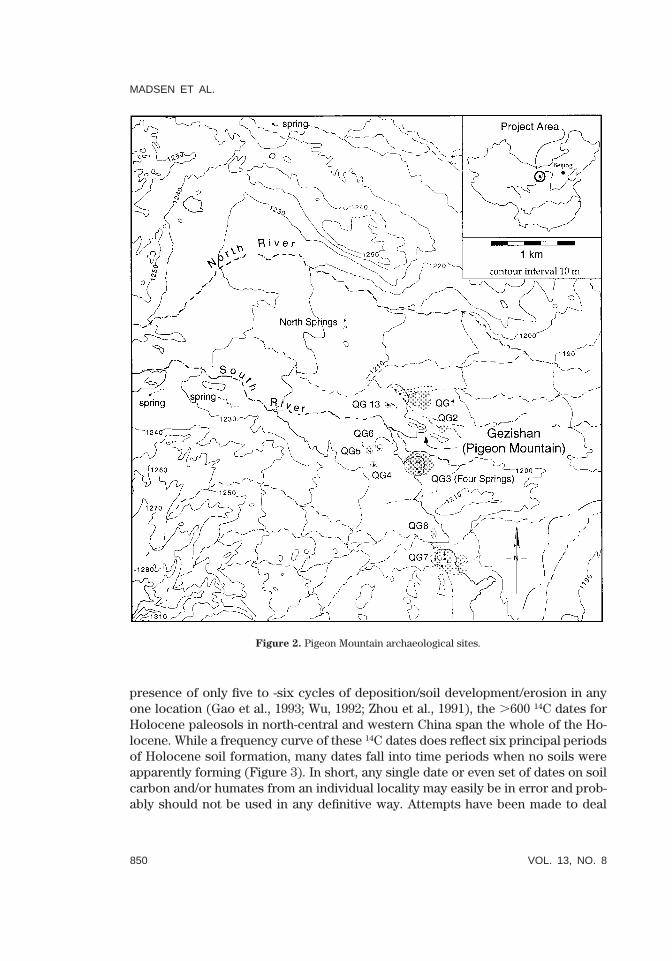
presence of only five to -six cycles of deposition/soil development/erosion in anyone location (Gao et al., 1993; Wu, 1992; Zhou et al., 1991), the .600 14C dates forHolocene paleosols in north-central and western China span the whole of the Ho-locene. While a frequency curve of these 14C dates does reflect six principal periodsof Holocene soil formation, many dates fall into time periods when no soils wereapparently forming (Figure 3). In short, any single date or even set of dates on soilcarbon and/or humates from an individual locality may easily be in error and prob-ably should not be used in any definitive way. Attempts have been made to deal
LOESS/PALEOSOL RECORD IN CENTRAL CHINA
GEOARCHAEOLOGY: AN INTERNATIONAL JOURNAL 851
shortstandard
GEA(Wiley) RIGHT BATCH
Figure 3. Frequency histogram of .600 14C dates from Holocene paleosols in north-central and westernChina (modified from Zhou et al., 1991). Gray-scale bars, added here, show approximate chronologicalposition of Holocene soils identified by Feng et al. (1993), Gao et al. (1993), Wu (1992), and Zhou et al.(1991).
with these problems in a variety of ways, including the dating of cellulose fromfossil wood (Head et al., 1989), pretreatment of charcoal fragments (Donahue,1993), and direct AMS dating of pollen (Zhou et al., 1996). Here, we use the datingof culturally deposited charcoal, rather than naturally deposited organic remains,to address chronological issues associated with the Younger Dryas loess/soil se-quence in central China.
These dating problems are compounded by the nature of Chinese loess soils andby the nature of the Younger Dryas itself. In many late Pleistocene-Holocene loess/paleosol sequences, two or more paleosols are often superimposed, producing pa-leosol complexes of overlapping, stratigraphically compressed, paleosols with agesspanning several thousands of years (Liu, 1985). In addition, Chinese paleosols canform very quickly, often in only a matter of 1 to 2 centuries (Maher and Thompson,1995), particularly those that are poorly developed and consist of only buried or-ganic A-horizons. As a result, the variance of the date(s) on a soil may significantlyexceed the actual time of soil formation. Where soils form during periods of veryrapidly changing climatic conditions, even a statistically accurate 14C date, whenused to extrapolate to other data, may suggest climatic conditions dramaticallydifferent from those under which the soil formed. This is a particularly troublingproblem during the period from 12,000–9000 radiocarbon years ago, when evendates with limited variance correspond to calendrical periods of 1000 years or more

MADSEN ET AL.
852 VOL. 13, NO. 8
shortstandard
GEA(Wiley) LEFT BATCH
(Bartlein et al., 1995). These problems are marked for the Younger Dryas, a climaticepisode that is both relatively short, lasting only ,1100 calender years, sharplybounded, both beginning and ending within 10–20 year periods, and highly variable(Alley et al., 1993; Goslar et al., 1995; Johnson et al., 1992; Mayewski et al., 1993).Thus, the climatic signal generated by soil formations dated at or near the ,11,600cal yr (,10,080 14C yr) end of the Younger Dryas are difficult to interpret.
LATE QUATERNARY ENVIRONMENTAL CHANGE IN CENTRAL
CHINA
What little is known about the Late Quaternary environmental conditions alongthe southern flanks of the Helan Mountains (Figure 1) must be extrapolated fromexternal sequences. To the east and south, these are primarily loess sequences (Anet al., 1990, 1991, 1993; Derbyshire, 1983; Kang, 1990; Sun and Zhao, 1991; Yuan,1978), while to the west and south these are primarily lake level sequences (Chenand Bowler, 1986; Fang, 1991; Huang and Cai, 1987; Lister et al., 1991; Geng andChen, 1990; Pachur et al., 1995). The definition of Holocene climatic change is basedprimarily on paleosol sequences (Wu, 1992; Zhou et al., 1991, 1994) and historicalrecords (Feng et al., 1993). Limited description and dating of alluvial sequences(Geng and Chan, 1992; Hofmann, 1994; Pachur et al., 1995) and dune sequences(Gao et al., 1993) are available for the Helan Mountains itself.
Along the margins of the Helan Mountains, as in most of north-central China,surfaces of Plio-Pleistocene loess, and associated fluvial and alluvial deposits, areheavily weathered and are characterized by a deep and extremely well-developedsoil. This erosional surface creates a vast unconformity on which local late Qua-ternary geomorphological sequences are built. In many areas, such as the Ordos tothe east of the Helan Mountains, the surface of this soil forms a vast peneplane towhich mixed deposits of Mid-to-Late Paleolithic materials have deflated. In thePigeon Mountain basin (Figure 2), as in the Ordos, a series of depositional anderosional sequences has been repeatedly built on, and eroded down to, this surface.As a result, most, if not all, of the mid-to-late Pleistocene sequence is missing. Atpresent, it is only possible to reconstruct the late Quaternary sequence from theregional paleoenvironmental history.
Late Quaternary climatic conditions are complex for China as a whole (Winklerand Wang, 1993), and local paleoenvironmental change is best described througha combination of a loess sequence from south of the Tengger Desert (An et al.,1993) and lake sequences from the Tengger itself (Pachur et al., 1995), refined withlocally available data. Between about 39 and 23 ka, cool summers and a higherprecipitation regime created a system of large lakes and semiaquatic environmentsin what is now the Tengger Desert. These higher lakes are associated with markedalluviation on the desert margins and increased water supply across the alluvialfans of the Helan Mountains (Hofmann, 1994). Increasing aridity after 18 ka led tothe complete desiccation of the Tengger lakes and the initiation of dune buildingon the lake floors. This aridity corresponds to the inception of the Malan loess,

LOESS/PALEOSOL RECORD IN CENTRAL CHINA
GEOARCHAEOLOGY: AN INTERNATIONAL JOURNAL 853
shortstandard
GEA(Wiley) RIGHT BATCH
Figure 4. Variation in the limits of the winter and summer monsoon during the Holocene in China.Stippled area is the modern monsoon climate region (after Winkler and Wang, 1993).
which began to accumulate at the Baxie section south of the Tengger by 17 ka.After about 13 ka, lakes approaching in size, but not as large as those of the earlierperiod, reappeared in the Tengger Desert and lasted until shortly after 11 ka. Evi-dence of increased spring activity during this period is evident on alluvial fans onboth the eastern (Hofmann, 1994) and western (Pachur et al., 1995) margins of theHelan Mountains. For the most part, this variation between periods of aridity andincreased annual precipitation has been attributed to the strengthening and weak-ening of the summer monsoon (An et al., 1991). While this may be true for most ofChina, the Helan Mountains and the eastern Tengger Desert are at the limit of thesummer monsoon’s effectiveness (Geng and Chan, 1992), and the role the wintermonsoon has played in creating the Tengger sequence remains unclear (Figure 4).
The moist interval between 13 and 11 ka was followed by a brief, but relativelyintense period of desiccation lasting from about 10.8 ka to after 10 ka during whichregional lakes again dried up and the Taohe Loess accumulated rapidly at the Baxiesection. The remainder of the Holocene is characterized by a similar pattern ofalternating periods of lake desiccation/aeolian activity and lake recharge/incipientsoil development (Gao et al., 1993). However, the overall trend is one of increasing

MADSEN ET AL.
854 VOL. 13, NO. 8
shortstandard
GEA(Wiley) LEFT BATCH
aridity throughout the Holocene, with sequent lake high stands reaching lowerelevations at each iteration (Geng and Chen, 1990; Pachur et al., 1995). Lake highstands are evident between about 8.7–7.3 ka, 6–4.6 ka, and 1.9–1.4 ka, and areinterleaved with episodes of increased aeolian activity and dune building. The pe-riods of increased available moisture suggested by these lake high stands appearto be contemporaneous with periods of soil formation and to periods of warmerand wetter climatic conditions (Liu, 1985; Zhou et al., 1994; Maher and Thompson,1995). Feng et al. (1993) recognize eight cool/dry periods separated by warm/wetintervals during the Holocene. Several of these are minor events, however, and thedifferential extent of summer monsoons into northwestern China (Winkler andWang, 1993; Zhou, et al. 1996) may account for some of the confusion in the paleo-sol record.
YOUNGER DRYAS AGE SOILS IN CENTRAL CHINA
The loess-paleosol sequence for the last 130,000 years in central China suggestsa strong correlation between the formation of paleosols, the extension of the sum-mer monsoon north and west into a more continental position, and changes towarmer and wetter conditions (An et al., 1991; Banerjee, 1995; Heller and Liu, 1986;Kemp et al., 1995; Maher and Thompson, 1992, 1995; Winkler and Wang, 1993). Thispattern is clearly documented for the well-developed Late Pleistocene soils, butalso is evident for less well-defined transitional and Early Holocene soils as well(An et al., 1990; Liu, 1985; Zhou et al., 1991, 1996). This pattern has also beendescribed for the extended Chinese historical period (Feng et al., 1993; Zhang, 1984;Zhou et al., 1994).
In north-central and western China, most data suggest the Younger Dryas isassociated with an aeolian deposition bracketed by two soils. In sections nearQinghai Lake on the extreme western margin of the Loess Plateau, the dates ontwo soils above and below dune sands are considered to be 12,300 6 100 and 99106 80 14C yr B.P. (Pan and Xu, 1989). This interval correlates well with nearby pollenand lake-level data growth (Van Campo and Gasse, 1993:310) suggesting “. . . in-creasing moisture and temperature after ca. 12,500 yr B.P. with a maximum at ca.11,500–11,000 yr B.P.” This is followed by “. . . a reversal event toward dry, coldconditions centered around 10,500 yr B.P. and end[ing] at ca. 9900 yr B.P.,” and“. . . a major environmental change, as brief as a few centuries, occurr[ing] . . .ca. 10,000–9,900 yr B.P. (ca. 11,000 cal yr), with the establishment of moist con-ditions favorable to vegetation.” This, in turn, matches a record from Qinghai Lakeitself, suggesting Younger Dryas aridity between 10,800 and 10,000 yr B.P. (Listeret al., 1991), as well as other paleoenvironmental data from the region (Pachur etal., 1995) and from China generally (Li, 1988; Winkler and Wang, 1993). An initialinterpretation of the Baxie section near Lanzhou (An et al., 1990) is in accord withthese records, suggesting two paleosols bracket a Younger Dryas-age loess depo-sition. The Baxie Soil was subsequently interpreted to indicate it formed throughoutthe Younger Dryas under cool but wet climatic conditions (An et al., 1993). How-

LOESS/PALEOSOL RECORD IN CENTRAL CHINA
GEOARCHAEOLOGY: AN INTERNATIONAL JOURNAL 855
shortstandard
GEA(Wiley) RIGHT BATCH
ever, more recent work at loess sections in the Ordos region within the great bendof the Yellow River (Zhou et al., 1996) suggest soil formation is limited to a briefperiod of increased precipitation within a Younger Dryas dominated by cool/dryconditions and aeolian deposition. A soil sequence we defined and dated in 1995and 1996 matches this interpretation.
PIGEON MOUNTAIN BASIN GEOMORPHOLOGY
The surface geomorphology of the Pigeon Mountain basin is a product of thislate Quaternary paleoenvironmental sequence (Figure 4). The basin itself is a shal-low drainage basin heading in the low foothills of the southern Helan Mountainswhere elevations reach less than 1600 m. Limited annual precipitation of less than150 mm/yr drains eastwards towards the Yellow River across a relatively shallowgradient averaging ,17 (in contrast to alluvial fan slopes along the central HelanMountains, which, as the result of intensive late Quaternary tectonic activity, rangefrom 27 to 47). Surface sediments consist, for the most part, of course, alluvium onthe resistant, and very well-developed, Plio-Pleistocene soil found throughout theregion. Isolated outcrops of bedrock materials form occasional low hills within thisalluvial plain. The largest of these is Pigeon Mountain itself, a low 100 m by l kmridge composed of a friable and rapidly weathering conglomerate, located approx-imately in the middle of the basin. The surface of this flat-topped ridge is less than30 m above the surrounding terrain.
Vegetative cover is extremely sparse across the basin and the surface is heavilydeflated down to gravels and cobbles in braided stream channels, and to the re-sistant Plio-Pleistocene soil on the relatively flat surfaces between active channels.These stream channels are marginally incised into the basal alluvium, but the in-termittent exposures are only about 1 m in depth. The Plio-Pleistocene soil is itselfformed on older alluvium composed primarily of coarse gravels and cobbles. Theseare cemented by the fine-grained clays and silts of an extremely well-developedsoil. The dark red B-horizon of this soil exceeds the 2 m of exposure available inchannel profiles. Repeated deflation to this surface has exposed gravel and cobbles(to 20 cm diameter) which form a gobi-like stony surface across the floor of thePigeon Mountain basin. Within the soil itself, however, many of the cobbles arealmost completely decomposed. The Plio-Pleistocene soil surface constitutes alandscape feature evident throughout the Pigeon Mountain basin and in cuts alongthe Yellow River terrace some 20 km to the east. Artifacts on this deflation surfacespan at least the last 30,000 years and most are highly polished by sand-blasting.Many are so eroded as to be almost unrecognizable as artifacts, and it is verypossible that any cultural materials older than the Late Paleolithic cannot be iden-tified as such due to intense wind modification.
The relatively flat and deflated gobi surface morphology is interrupted in a num-ber of locations by spring mounds composed of stratified dunes surrounding oneor more small spring throats. The springs occur along a line oriented 157 west ofnorth and may be fault related. No evidence of spring deposits older than ,15 ka

MADSEN ET AL.
856 VOL. 13, NO. 8
shortstandard
GEA(Wiley) LEFT BATCH
Fig
ure
5.
Spri
ngm
ound
/dun
eco
mpl
exat
the
QG
3lo
calit
yin
the
Pig
eon
Mou
ntai
nba
sin.

LOESS/PALEOSOL RECORD IN CENTRAL CHINA
GEOARCHAEOLOGY: AN INTERNATIONAL JOURNAL 857
shortstandard
GEA(Wiley) RIGHT BATCH
have yet been identified and the springs may be associated with a fault dating tothat period. Eight such dune/spring mounds were identified within the PigeonMountain basin, but the basin was incompletely surveyed during this preliminaryinvestigation phase, and there may be others. These spring mounds appear to varyin size according to the number of spring throats and the amount of spring dis-charge at each location. The largest is more than 100 m in diameter and 10 m high,while the smallest is less than 10 m in diameter and 2 m high. The number of springthroats at any one spring mound varies from one to four. Discharge was not mea-sured directly, but appears to vary from as little as 0.001 m3/s to as much as 1 m3/s or more. The largest of these are currently used for irrigation and spring flow isdiverted through underground piping systems to nearby fields. In some localitiesaeolian deposits associated with these mounds at times extended across the basinfloor, damming the low-gradient spring-fed streams, creating a series of shallowponds. Without exception, prehistoric cultural materials within the Pigeon Moun-tain basin are associated with spring mounds and they were the focus of our in-vestigations. One spring was tested extensively, small exploratory exposures wereexcavated at two more, and shovel scrapes were used to evaluate dune stratigraphyat a number of others. These exposures suggest a relatively uniform depositionalsequence at all spring mound locations.
The spring mounds are composed of aeolian sands which appear to have beenpart of a dune complex that covered much of the Pigeon Mountain basin a numberof times during the Holocene (Figure 5). This basin-wide cover of aeolian sandsappears to have built and deflated in concert with the Holocene climatic sequencedefined above. Calcareous tufas are also present at virtually every spring locality,but it is not yet clear how these tufas relate chronologically to the depositionalsequence at the spring mounds and to the overall climatic sequence. They may besimilar in age to calcareous crusts on the east and west slopes of the Helan Moun-tains dating to 13–12 ka (Hofmann, 1994), but they may also be composites of tufaslaid down during multiple periods of increased spring flow.
To some extent, the spring mound dunes are self-generating, with aeolianmaterials deposited in and around the spring-supported vegetation during periodsof aggradation. During periods of deflation, areas around the spring complexeswere protected and stabilized by this same spring-fed vegetative cover, whileaway from the springs the aeolian sands were eroded completely down to themore resistant Plio-Pleistocene soil. Dune profiles within the spring moundsexhibit repetitive cycles of aeolian deposition and stabilization, developmentof an incipient soil and/or organic spring mat, and creation of a deflation sur-face and erosional unconformity. The sequence is then repeated in overlying strata.Four to five such cycles are evident at the QG3 mound and may be present in theother large spring mounds as well. In some of the small mounds, supported by onlysmall springs, several of the most recent cycles appear to be missing, probablybecause the upper most materials have been deflated during the current erosionalcycle.

MADSEN ET AL.
858 VOL. 13, NO. 8
shortstandard
GEA(Wiley) LEFT BATCH
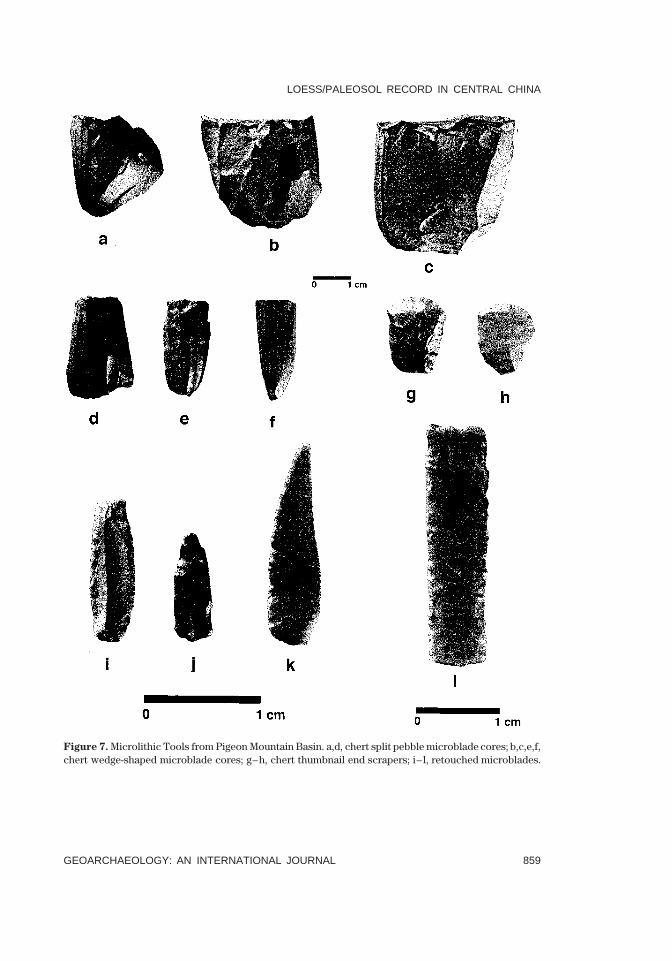
Figure 6. Macrolithic Tools from Pigeon Mountain Basin. a–e, quartzite Helan Points; f, quartzite utilizedflake; g, quartzite unifacial scraper; h, greedstone convergent scraper.
LITHIC ARTIFACTS OF PIGEON MOUNTAIN BASIN
Pigeon Mountain Basin lithic artifacts suggest a lithic technology incorporatingboth macrolithic (Figure 6) and microlithic (Figure 7) elements. Macrolithics, madeof quartzite, metavolcanics (greenstone), and fine grained sandstone, include HelanPoints (Figure 6[a–e]), a distinctive series of bifaces and unifaces similar to those
LOESS/PALEOSOL RECORD IN CENTRAL CHINA
GEOARCHAEOLOGY: AN INTERNATIONAL JOURNAL 859
shortstandard
GEA(Wiley) RIGHT BATCH
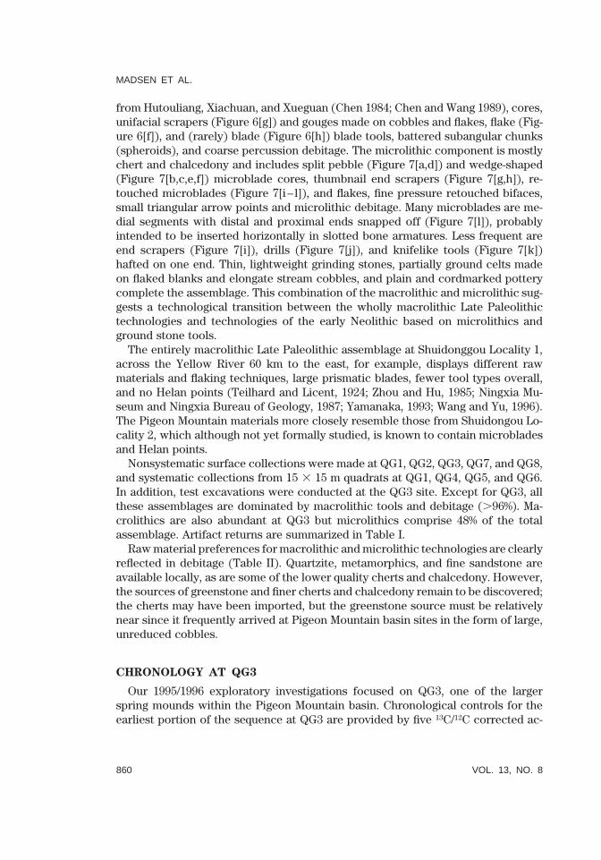
Figure 7. Microlithic Tools from Pigeon Mountain Basin. a,d, chert split pebble microblade cores; b,c,e,f,chert wedge-shaped microblade cores; g–h, chert thumbnail end scrapers; i– l, retouched microblades.
MADSEN ET AL.
860 VOL. 13, NO. 8
shortstandard
GEA(Wiley) LEFT BATCH
from Hutouliang, Xiachuan, and Xueguan (Chen 1984; Chen and Wang 1989), cores,unifacial scrapers (Figure 6[g]) and gouges made on cobbles and flakes, flake (Fig-ure 6[f]), and (rarely) blade (Figure 6[h]) blade tools, battered subangular chunks(spheroids), and coarse percussion debitage. The microlithic component is mostlychert and chalcedony and includes split pebble (Figure 7[a,d]) and wedge-shaped(Figure 7[b,c,e,f]) microblade cores, thumbnail end scrapers (Figure 7[g,h]), re-touched microblades (Figure 7[i– l]), and flakes, fine pressure retouched bifaces,small triangular arrow points and microlithic debitage. Many microblades are me-dial segments with distal and proximal ends snapped off (Figure 7[l]), probablyintended to be inserted horizontally in slotted bone armatures. Less frequent areend scrapers (Figure 7[i]), drills (Figure 7[j]), and knifelike tools (Figure 7[k])hafted on one end. Thin, lightweight grinding stones, partially ground celts madeon flaked blanks and elongate stream cobbles, and plain and cordmarked potterycomplete the assemblage. This combination of the macrolithic and microlithic sug-gests a technological transition between the wholly macrolithic Late Paleolithictechnologies and technologies of the early Neolithic based on microlithics andground stone tools.
The entirely macrolithic Late Paleolithic assemblage at Shuidonggou Locality 1,across the Yellow River 60 km to the east, for example, displays different rawmaterials and flaking techniques, large prismatic blades, fewer tool types overall,and no Helan points (Teilhard and Licent, 1924; Zhou and Hu, 1985; Ningxia Mu-seum and Ningxia Bureau of Geology, 1987; Yamanaka, 1993; Wang and Yu, 1996).The Pigeon Mountain materials more closely resemble those from Shuidongou Lo-cality 2, which although not yet formally studied, is known to contain microbladesand Helan points.
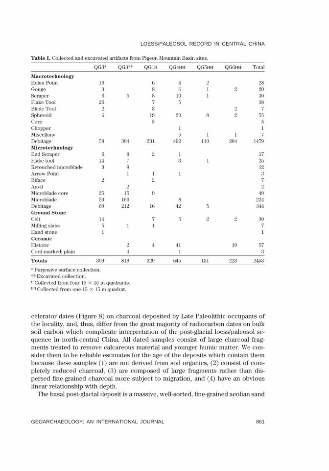
Nonsystematic surface collections were made at QG1, QG2, QG3, QG7, and QG8,and systematic collections from 15 3 15 m quadrats at QG1, QG4, QG5, and QG6.In addition, test excavations were conducted at the QG3 site. Except for QG3, allthese assemblages are dominated by macrolithic tools and debitage (.96%). Ma-crolithics are also abundant at QG3 but microlithics comprise 48% of the totalassemblage. Artifact returns are summarized in Table I.
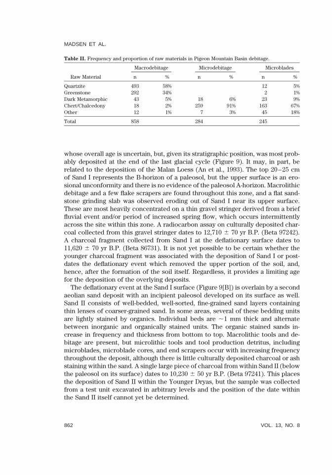
Raw material preferences for macrolithic and microlithic technologies are clearlyreflected in debitage (Table II). Quartzite, metamorphics, and fine sandstone areavailable locally, as are some of the lower quality cherts and chalcedony. However,the sources of greenstone and finer cherts and chalcedony remain to be discovered;the cherts may have been imported, but the greenstone source must be relativelynear since it frequently arrived at Pigeon Mountain basin sites in the form of large,unreduced cobbles.
CHRONOLOGY AT QG3
Our 1995/1996 exploratory investigations focused on QG3, one of the largerspring mounds within the Pigeon Mountain basin. Chronological controls for theearliest portion of the sequence at QG3 are provided by five 13C/12C corrected ac-
LOESS/PALEOSOL RECORD IN CENTRAL CHINA
GEOARCHAEOLOGY: AN INTERNATIONAL JOURNAL 861
shortstandard
GEA(Wiley) RIGHT BATCH
Table I. Collected and excavated artifacts from Pigeon Mountain Basin sites.
QG3* QG3** QG1H QG4HH QG5HH QG6HH Total
Macrotechnology
Helan Point 16 6 4 2 28Gouge 3 8 6 1 2 20Scraper 6 5 8 10 1 30Flake Tool 26 7 5 38Blade Tool 2 3 2 7Spheroid 6 19 20 8 2 55Core 5 5Chopper 1 1Miscellany 5 1 1 7Debitage 58 384 231 492 110 204 1479Microtechnology
End Scraper 6 8 2 1 17Flake tool 14 7 3 1 25Retouched microblade 3 9 12Arrow Point 1 1 1 3Biface 2 2 7Anvil 2 2Microblade core 25 15 9 49Microblade 50 166 8 224Debitage 69 212 16 42 5 344Ground Stone
Celt 14 7 5 2 2 30Milling slabs 5 1 1 7Hand stone 1 1Ceramic
Historic 2 4 41 10 57Cord-marked; plain 4 1 3
Totals 309 816 329 645 131 223 2453
* Purposive surface collection.** Excavated collection.H Collected from four quadrants.15 3 15 mHH Collected from one quadrat.15 3 15 m
celerator dates (Figure 8) on charcoal deposited by Late Paleolithic occupants ofthe locality, and, thus, differ from the great majority of radiocarbon dates on bulksoil carbon which complicate interpretation of the post-glacial loess/paleosol se-quence in north-central China. All dated samples consist of large charcoal frag-ments treated to remove calcareous material and younger humic matter. We con-sider them to be reliable estimates for the age of the deposits which contain thembecause these samples (1) are not derived from soil organics, (2) consist of com-pletely reduced charcoal, (3) are composed of large fragments rather than dis-persed fine-grained charcoal more subject to migration, and (4) have an obviouslinear relationship with depth.
The basal post-glacial deposit is a massive, well-sorted, fine-grained aeolian sand
MADSEN ET AL.
862 VOL. 13, NO. 8
shortstandard
GEA(Wiley) LEFT BATCH
Table II. Frequency and proportion of raw materials in Pigeon Mountain Basin debitage.
Raw Material
Macrodebitage
n %
Microdebitage
n %
Microblades
n %
Quartzite 493 58% 12 5%Greenstone 292 34% 2 1%Dark Metamorphic 43 5% 18 6% 23 9%Chert/Chalcedony 18 2% 259 91% 163 67%Other 12 1% 7 3% 45 18%
Total 858 284 245
whose overall age is uncertain, but, given its stratigraphic position, was most prob-ably deposited at the end of the last glacial cycle (Figure 9). It may, in part, berelated to the deposition of the Malan Loess (An et al., 1993). The top 20–25 cmof Sand I represents the B-horizon of a paleosol, but the upper surface is an ero-sional unconformity and there is no evidence of the paleosol A-horizon. Macrolithicdebitage and a few flake scrapers are found throughout this zone, and a flat sand-stone grinding slab was observed eroding out of Sand I near its upper surface.These are most heavily concentrated on a thin gravel stringer derived from a brieffluvial event and/or period of increased spring flow, which occurs intermittentlyacross the site within this zone. A radiocarbon assay on culturally deposited char-coal collected from this gravel stringer dates to 12,710 6 70 yr B.P. (Beta 97242).A charcoal fragment collected from Sand I at the deflationary surface dates to11,620 6 70 yr B.P. (Beta 86731). It is not yet possible to be certain whether theyounger charcoal fragment was associated with the deposition of Sand I or post-dates the deflationary event which removed the upper portion of the soil, and,hence, after the formation of the soil itself. Regardless, it provides a limiting agefor the deposition of the overlying deposits.
The deflationary event at the Sand I surface (Figure 9[B]) is overlain by a secondaeolian sand deposit with an incipient paleosol developed on its surface as well.Sand II consists of well-bedded, well-sorted, fine-grained sand layers containingthin lenses of coarser-grained sand. In some areas, several of these bedding unitsare lightly stained by organics. Individual beds are ,1 mm thick and alternatebetween inorganic and organically stained units. The organic stained sands in-crease in frequency and thickness from bottom to top. Macrolithic tools and de-bitage are present, but microlithic tools and tool production detritus, includingmicroblades, microblade cores, and end scrapers occur with increasing frequencythroughout the deposit, although there is little culturally deposited charcoal or ashstaining within the sand. A single large piece of charcoal from within Sand II (belowthe paleosol on its surface) dates to 10,230 6 50 yr B.P. (Beta 97241). This placesthe deposition of Sand II within the Younger Dryas, but the sample was collectedfrom a test unit excavated in arbitrary levels and the position of the date withinthe Sand II itself cannot yet be determined.

LOESS/PALEOSOL RECORD IN CENTRAL CHINA
GEOARCHAEOLOGY: AN INTERNATIONAL JOURNAL 863
shortstandard
GEA(Wiley) RIGHT BATCH
Figure 8. Lithology and associated radiocarbon dates of the QG3 aeolian/paleosol sequence, PigeonMountain basin, Ningxia, China. Dashed line indicates position of gravel stringer.
A highly organic A-horizon was formed on the surface of Sand II (Figure 9[A]),but there is little evidence of additional soil development below this humus zone,and it appears to be primarily an organic spring mat formed on top of aeolian sands,a feature common to many quickly forming Holocene paleosols (Liu, 1985). Tworadiocarbon samples composed of culturally deposited charcoal recovered fromthis organic mat date to 10,060 6 60 yr B.P. (Beta 86732), and 10,120 6 60 yr B.P.(Beta 94119). The aeolian deposition of Sand II is thus bracketed to a period of,1600 radiocarbon years between 11.6 and 10 ka, a period which correspondsalmost exactly with age determinations for the Younger Dryas derived from icecores (Mayewski et al., 1993).
CULTURAL SEQUENCE
Table III summarizes the stratigraphic distribution of artifacts recovered fromQG3 grouped by major stratigraphic unit, Sand I and Sand II. Artifacts from theunsystematic general surface collections are also enumerated for comparison.Given the nearly 3000-year depositional span represented by the two sands, differ-

MADSEN ET AL.
864 VOL. 13, NO. 8
shortstandard
GEA(Wiley) LEFT BATCH
Fig
ure
9.
Vie
wof
expo
sed
profi
leat
QG
3.(A
)T
row
elpo
ints
toth
eto
pof
the
Sand
IIse
quen
ce.(
B)
Arr
owpo
ints
toer
osio
nals
urfa
cebe
twee
nSa
ndI
and
Sand
II.

LOESS/PALEOSOL RECORD IN CENTRAL CHINA
GEOARCHAEOLOGY: AN INTERNATIONAL JOURNAL 865
shortstandard
GEA(Wiley) RIGHT BATCH
Table III. Stratigraphic distribution of artifacts from QG3.
GeneralSurface
ExcavatedSurface
SandII
SandII/I
SandI
SiteTotal
Microtechnology
End Scraper 5 1 6 1 1 14Flake Tool 14 3 1 3 21Retouched Microblade 3 8 1 12Arrow Point 1 1Biface 5 5Anvil 2 2Microblade Core 19 6 9 2 4 40Microblade 4 46 150 2 10 212Debitage 50 19 130 3 28 230Macrotechnology
Helan Point 16 16Gouge 3 3Scraper 6 2 3 11Flake Tool 26 26Blade Tool 2 2Spheroid 6Debitage 58 58 136 91 157 500Ground Stone
Celt 14 14Grinding Stone 3 1 4Hand Stone 2 2Ceramic
Historic 2 2Plain 2 2Cord-marked 2 2Fauna
Cut & Polished Bone 1 1Bones and Teeth 103 781 3 34 921
Total 242 241 1221 107 238 2043
ences between the two units in relative amounts of macrolithic and microlithicartifacts may address cultural adaptation and development in this critical transi-tional period. Although the sample of excavated macrolithic tools is small, all fiveare from Sand I or the Sand1/II interface. Macrolithic debitage is more abundantin Sand I, and relatively less so in Sand II (df 1, Chi Square 5 126.87; p 5 0.0001),while numbers of microlithic tools and debitage drastically increase in Sand II. Thismay indicate an increasing displacement of macrolithic technology by microlithictechnology after ,11.6 ka. The slab grinding stone from Sand I apparently datesto between ,12,710 and ,11,620 radiocarbon years ago, making it one of the ear-liest known in northern China (Underhill, 1997).

MADSEN ET AL.
866 VOL. 13, NO. 8
shortstandard
GEA(Wiley) LEFT BATCH
SUMMARY
Data from the Pigeon Mountain basin, based on culturally derived charcoal datesrather than on soil humus, suggest a Younger Dryas aeolian deposition is bracketedby two soils dating to 12–11 ka and to ,10 ka. The Pigeon Mountain basin sequencecorresponds to other loess/paleosol sequences in the region (Pan and Xu, 1989),which, together, suggest the Younger Dryas in north-central and western China wascharacterized primarily by aeolian deposition. These loess/paleosol data, in turn,correspond to lake level sequences (Lister et al., 1991; Pachur et al.,1995) and tovegetational data (Li, 1988; Van Campo and Gasse, 1993; Winkler and Wang, 1993),which also suggest the Younger Dryas in central and western China was generallya period of colder and drier climatic conditions, with a reduced summer monsooninfluence very much like other cold periods in the late Quaternary paleoclimaticsequence of China.
The QG3 paleosol sequence is not sufficiently complete to address the possibleoccurrence of a brief soil-forming interval within the Younger Dryas, as suggestedby Zhou et al. (1996), although the nature of the Sand II deposits does suggest ahigh degree of climatic variability during the Younger Dryas (Mayewski et al., 1993).This climatic variability immediately before, during, and after the Younger Dryas,appears to be associated with a transition to broad-spectrum foraging and seedprocessing by hunter-gatherers in western and central China, and, ultimately to theadvent of agriculture.
We thank D. Dugas, J. King, Feng Z., M. Lowe, and D. Grayson for discussion and review, andM. Shaver III for graphics assistance. This work was supported by the National Science Foundation, theNational Geographic Society, and the Utah Geological Survey.
REFERENCES
Alley, R.B., Meese, D.A., Shuman, C.A., Gow, A.J., Taylar, K.C., Grootes, P.M, White, J.W.C., Ram, M.,Waddington, E.D., Mayewski, P.A., and Zielinski, G.A. (1993). Abrupt Increase in Greenland SnowAccumulation at the End of the Younger Dryas Event. Nature 362, 527–529.
An, Z., Wu, X., Lu, Y., Zhang, D., Sun, X., and Dong, G. (1990). A preliminary Study of PaleoenvironmentalChange of China During the Last 20,000 years. In T. Liu, Ed., Loess, Quaternary Geology and Global
Change, Part 2, pp. 1–26. Beijing: Science Press [in Chinese].An, Z., Kukla, G.J., Porter, S.C., and Xiao, J. (1991). Magnetic Susceptibility Evidence of Monsoon Vari-
ation on the Loess Plateau of Central China During the Last 130,000 years. Quaternary Research 36,
29–36.An, Z., Porter, S.C., Zhou, W., Lu, Y., Donahue, D.J., Head, M.J., Wu, X., Ren, J., and Zheng, H. (1993).
Episode of Strengthened Summer Monsoon Climate of Younger Dryas Age on the Loess Plateau ofCentral China. Quaternary Research 39, 45–54.
Banerjee, S.K. (1995). Chasing the Paleomonsoon Over China: Its Magnetic Proxy Record. GSA Today
5, 93–97.Bartlein, P.J., Edwards, M.E., Shafer, S. L., and Barker, E.D., Jr. (1995). Calibration of Radiocarbon Ages
and the Interpretation of Paleoenvironmental Records. Quaternary Research 44, 417–424.Becker-Heidmann, P., and Harkness, D. (1995). Report of the Radiocarbon in Soils Workshop. Radio-
carbon 37, 818–819.Bettinger, R.L., Madsen, D.B., and Elston, R.L. (1994). Prehistoric Settlement Categories and Settlement
LOESS/PALEOSOL RECORD IN CENTRAL CHINA
GEOARCHAEOLOGY: AN INTERNATIONAL JOURNAL 867
shortstandard
GEA(Wiley) RIGHT BATCH
Systems in the Alashan Desert of Inner Mongolia. Journal of Anthropological Archaeology 13, 74–101.
Chen, C. (1984) The Microlithic of China. Journal of Anthropological Archaeology 3, 79–115.Chen, K., and Bowler, J.M. (1986). Late Pleistocene Evolution of Salt Lakes in the Qaidam Basin,Qinghia
Province, China. Paleogeography, Paleoclimatology, Paleoecology 54, 131–152.Chen, C., and Wang X. (1989) Upper Paleolithic Microblade Industries in North China and Their Rela-
tionships with Northeast Asia and North America. Arctic Anthropology 26, 127–156.Chichagova, O.A., and Cherkinsky, A.E. (1993). Problems in Radiocarbon Dating of Soils. Radiocarbon
35, 351–362.Derbyshire, E. (1983). On the Morphology, Sediments, and Origin of the Loess Plateau of Central China.
In R. Gardner and H. Scoging, Eds., Megageomorphology, pp. 172–194. London: Clarenden Press.Donahue, D.J. (1993). Measurements of Radiocarbon Ages at the University of Arizona Accelerator Mass
Spectrometer Facility. Collect Oceanic Works 16, 56–69.Elston, R.G., Madsen, D.B., Bettinger, R.L., Brantingham, P.J., Xu, C., Zhong, K., and Li, J. (1997). Pigeon
Mountain and the Implications for the Paleolithic-Neolithic Transition in North-Central China. An-
tiquity 71, 985–993.Evans, L.J. (1985). Dating Methods of Pleistocene Deposits and Their Problems: VII. Paleosols. In N.W.
Rutter, Ed., Dating Methods of Pleistocene Deposits and Their Problems, pp. 53–59. GeoscienceCanada, Reprint Series 2. St. John’s: Geological Association of Canada.
Fang, J. (1991). Lake Evolution during the Last 30,000 Years in China, and Its Implication for Environ-mental Changes. Quaternary Research 36, 37–60.
Feng, Z., Thompson, L.G., Mosley-Thompson, E., and Yao, T. (1993). Temporal and Spatial Variation ofClimate in China During the Last 10,000 years. The Holocene 3, 174–180.
Forman, S. L. (1991). Late Pleistocene Chronology of Loess Depositions Near Louchuan, China. Qua-
ternary Research 36, 19–28Gao, S., Jin, H., Chen, W., Dong, G., Li, B., Liu, Q., and Jin, J. (1993). Deserts of the Holocene Megathermal
in China. Science in China (Series B) 23, 201–208 (in Chinese).Geng, K., and Chan, P.F. (1992). Yinchuan: Past, Present and Future: The Process of Geographic En-
vironmental Evolution from the Late 4th Century, Its Characteristics and Regulations. Beijing:Cartographic Publishing House [in Chinese].
Geng, K., and Chen, Y. (1990). Formation, Development and Evolution of the Jilanti Salt Lake, InnerMongolia. Chinese Journal of Arid Land Research 3, 57–67.
Goslar, T., Arnold, M., and Pazdur, M.F. (1995). The Younger Dryas Cold Event—. Was It Synchronousover the North Atlantic Region? Radiocarbon 37, 63–70.
Head, M.J., Zhou, W., and Zhou, M. (1989). Evaluation of 14C Ages of Oorganic Fractions of Paleosolsfrom Loess-Paleosol Sequences Near Xian, China. Radiocarbon 31, 680–696.
Heller, F., and Liu, T. (1986). Palaeoclimatic and Sedimentary History from Magnetic Susceptibility ofLoess in China. Geophysical Research Letters 13, 1169–1172.
Hofmann, J. (1994). Geomorphologische Untersuchungen zur jungquartren Klimaentwicklung des He-
lan Shan and seines westlichen Vorlendes. Berlin: Berliner Geographische Abhandlungen 57.Huang, Q., and Cai, B. (1987). Geochronological Study on the Sediments in Qaran Lake. In The Com-
mittee of Sino-Australian Joint Quaternary Research, Eds., Proceedings, Sino-Australian Quater-
nary Symposium, pp. 106–114. Beijing: Science Press.Jin, J., and Xu, H. (1992). Opinions about the Early Neolithic Site of Nanzhuangtou at Xushui. Kaogu
11, 1018–1022 (in Chinese).Johnson, S.J. Clausen, H.B., Dansgaard, W., Fuhrer, K., Gundestrup, N., Hammer, C.U., Iverson, P.,
Jonzel, J., Stauffer, B., and Steffensen, J.P. (1992). Irregular Glacial Interstadials Recorded in NewGreenland Ice Core. Nature 359, 311–313.
Kang, J. (1990). The Glacial Sequence, Loess Records, and Their Relation with Environmental Changesin West China. Ph.d. Thesis, Lanzhou University, Lanzhou (in Chinese).
Kemp, R.A., Derbyshire, E., Xingmin, M., Fahu, C., and Baotian, P. (1995). Pedosedimentary Reconstruc-tion of a Thick Loess-Paleosol Sequence Near Lanzhou in North-Central China. Quaternary Research
43, 30–45.

MADSEN ET AL.
868 VOL. 13, NO. 8
shortstandard
GEA(Wiley) LEFT BATCH
Li, T. (1988). A Preliminary Study on the Climatic and Environmental Changes at the Turn from Pleis-tocene to Holocene in East Asia. Geojournal 17, 649–657.
Lister, G.S., Kelts, K., Zao, C.K., Yu, J.Q., and Niessen, F. (1991). Lake Qinghai, China: Close-basin LakeLevels and the Oxygen Isotope Record for Ostracoda since the Latest Pleistocene. Paleogeography,
Paleoclimatology, Paleoecology 84, 141–162.Liu, T., Ed., (1985). Loess and the Environment. Beijing: China Ocean Press.Liu, X., Shaw, J., Liu, T., Heller, F., and Yuan, B. (1992). Magnetic Mineralogy of Chinese Loess and Its
Significance. Geophysical Journal International 108, 301–308.Madsen, D.B., Elston, R.G., Bettinger, R.L., Xu, C., and Zhong, K. (1996). Settlement Patterns Reflected
in Assemblages from the Pleistocene/Holocene Transition of North Central China. Journal of Ar-
chaeological Science 23, 217–231.Maher, B.A., and Thompson R. (1992). Paleoclimatic Significance of the Mineral Magnetic Record of the
Chinese Loess and Paleosols. Quaternary Research 37, 155–170.Maher, B.A., and Thompson R. (1995). Paleorainfall Reconstructions from Pedogenic Magnetic Suscep-
tibility Variations in the Chinese Loess and Palesols. Quaternary Research 44, 383–391.Mayewski, P.A., Meeker, L.D., Whitlow, S., Twickler, M.S., Morrison, M.C., Alley, R.B., Bloomfield, P.,
and Taylor, K. (1993). The Atmosphere during the Younger Dryas. Science 261, 195–197.Ningxia Museum and Ningxia Bureau of Geology, Chu Cheng Geological Research Team. (1987). Report
on the 1980 Excavations at Shuidonggou. Kaogu Xuebao 4, 439–448 (in Chinese).Orlova, L.A., and Panychev, V.A. (1993). The Reliability of Radiocarbon Dating Buried Soils. Radiocarbon
35, 3691–377.Pachur, H., Wunnemann, B., and Hucai, Z. (1995). Lake Evolution in the Tengger Desert, Northwestern
China, during the Last 40,000 Years. Quaternary Research 44, 171–180.Pan, B., and Xu, S. (1989). Discussion of Late Quaternary Environments in Eastern Qinghai Plateau.
Science Bulletin 7, 534–536 (in Chinese).Ren, S. (1995). Important Results Regarding Neolithic Cultures in China Earlier than 5000 B.C. Kaogu
1(1995): 710–718.Rutter, N., and Ding, Z.L. (1993). Paleoclimates and Monsoon Variations Interpreted from Micromor-
phogenic Features of the Baoji Paleosols. Quaternary Science Reviews 12, 853–862.Scharpenseel, H.W., (1971). Radiocarbon Dating of the Soil. Pedology 1, 34–42.Scharpenseel, H.W., and Becker-Heidmann, P. (1992). Twenty-five Years of Radiocarbon Dating Soils:
Paradigm of Erring and Learning. Radiocarbon 34, 541–549.Scharpenseel, H.W., and Schiffmann, H. (1977). Radiocarbon Dating of Soils—A Review. Zeitschrift fur
Pflanzenernahrung Dungung und Bodenkunde 140, 159–174.Sun, J., and Zhao, J., Eds. (1991). Quaternary of Loess Plateau in China. XIII INQUA Congress Series.
Beijing: Science Press (in Chinese).Teilhard de Chardin, P., and Licent, E. (1924). On the Discovery of a Palaeolithic Industry in Northern
China. Bulletin of the Geological Society of China 3, 45–50.Underhill, A.P., (1997). Current Issues in Chinese Neolithic Archaeology. Journal of World Prehistory
11, 103–160.Van Campo, E., and Gasse, F. (1993). Pollen- and Diatom-Inferred Climatic and Hydrological Changes
in Sumxi Co Basin (Western Tibet) since 13,000 yr B.P. Quaternary Research 39, 300–313.Wang, H., and Yu, J. (1996) A Report on Investigation at the Pigeon Mountain Site, Qing Tong Xia. In
C. Xu and X. Li, Eds., Archaeology in Ningxia, pp. 2–17. Yinchuan: Ningxia People’s Press.Winkler, M.G., and Wang, P.K. (1993). The Late-Quaternary Vegetation and Climate of China. In H.E.
Wright, Jr., J.E. Kutzbach, T. Webb, III, W.F. Ruddiman, F.A. Street-Perrott, and P.J. Bartlein, Eds.,Global Climates since the Last Glacial Maximum, pp. 221–261. Minneapolis: University of Minne-sota Press.
Wu, W. (1992). Paleosols and Their Environmental Significance during Holocene in Daqingshan Moun-tain Region of Inner Mongolia, North China. Journal of Chinese Geography 3, 72–83.
Yamanaka, I. (1993) The Lithic Industry of the Site of Shuidonggou in the Ordos of China. Kyoto Uni-
versity Faculty of Letters Research Bulletin 32, 105–154.
LOESS/PALEOSOL RECORD IN CENTRAL CHINA
GEOARCHAEOLOGY: AN INTERNATIONAL JOURNAL 869
shortstandard
GEA(Wiley) RIGHT BATCH
Yuan, B. (1978). Sedimentary Environment and Stratigraphic Subdivision in North China. Acta Geologica
Sinica 3, 220–234 (in Chinese).Zhang, D. (1984). Synoptic-Climatic Studies of Dust Fall in China since Historic Times. Scientia Sinica
(Series B) 27, 825–836 (in Chinese).Zhang, X., An, Z., Chen, T., Zhang, G., Arimoto, R., and Ray, B.J. (1994). Late Quaternary Records of the
Atmospheric Input of Eolian Dust to the Center of the Chinese Loess Plateau. Quaternary Research
41, 35–43.Zhou, K., and Jilan, H. (1985) The Paleoenvironment of the Shuidonggou Site of Ancient Cultural Remains
in Lingwo County, Ningxia. In T. Liu, Ed., Quaternary Geology and Environment of China, pp. 1–85. New York: Springer-Verlag.
Zhou, S.Z., Chen, F.H., Pan, B.T., Cao, J.X., Li, J.J., and Derbyshire, E. (1991). Environmental Changeduring the Holocene in Western China on a Millenial Timescale. The Holocene 1, 151–156.
Zhou, W., An, Z., and Head, M.J. (1994). Stratigraphic Division of Holocene Loess in China. Radiocarbon
36, 37–45.Zhou, W., Donahue, D.J., Porter, S.C., Jull, T.A., Li, X., Stuiver, M., An, Z., Matsumoto, E., and Dong, G.
(1996). Variability of Monsoon Climate in East Asia at the End of the Last Glaciation. Quaternary
Research 46, 219–229.
Received April 7, 1997
Accepted for Publication June 20, 1998