the major natural regions: an essay in systematic ... and...the major natural regions: an essay in...
TRANSCRIPT
The Major Natural Regions: An Essay in Systematic Geography
A. J. Herbertson
The Geographical Journal, Vol. 25, No. 3. (Mar., 1905), pp. 300-310.
Stable URL:
http://links.jstor.org/sici?sici=0016-7398%28190503%2925%3A3%3C300%3ATMNRAE%3E2.0.CO%3B2-1
The Geographical Journal is currently published by The Royal Geographical Society (with the Institute of BritishGeographers).
Your use of the JSTOR archive indicates your acceptance of JSTOR's Terms and Conditions of Use, available athttp://www.jstor.org/about/terms.html. JSTOR's Terms and Conditions of Use provides, in part, that unless you have obtainedprior permission, you may not download an entire issue of a journal or multiple copies of articles, and you may use content inthe JSTOR archive only for your personal, non-commercial use.
Please contact the publisher regarding any further use of this work. Publisher contact information may be obtained athttp://www.jstor.org/journals/rgs.html.
Each copy of any part of a JSTOR transmission must contain the same copyright notice that appears on the screen or printedpage of such transmission.
The JSTOR Archive is a trusted digital repository providing for long-term preservation and access to leading academicjournals and scholarly literature from around the world. The Archive is supported by libraries, scholarly societies, publishers,and foundations. It is an initiative of JSTOR, a not-for-profit organization with a mission to help the scholarly community takeadvantage of advances in technology. For more information regarding JSTOR, please contact [email protected].
http://www.jstor.orgTue Aug 28 19:05:17 2007
300 THE MAJOR NATURAL REGIONS: AN ESSAY IN SYSTEMATIC GEOGRAPHY.
THEMAP.-The map has been compiled as follows : The sources of the Liaq- or Lao Ho (K1le)-from inquiries made by myself when travelling in south-eastern Mongolia, especially from data supplied by the Rev. John Parker (London Missionary Society), who worked the whole region. Later I sent a fairly well-trained native to gather all the information he could, and I depended on him for the section from Hada to the northernmost point. The Sira Rfuren is inserted from Russian sources, which are not quite reliable. From the most northern point to the mouth the river has been, on the whole, carefully sketched by myself; a few main places were fixed for latitude and longitude, etc. (the latitude is the nore correct), and other details from compass-bearings. I am very familiar with the whole of the river anti its tributaries from the northernmost bend to the sea. I have been much about the Eastern desert and the curious disappearing rivers.
THE MAJOR NATURAL REGIONS : AN ESSAY IN SYSTEMATIC GEOGRAPHY.*
By A. J. HERBERTSON, M.A., Ph.D.
T~ross of us who teach geography in the Universities have constantly to ansrver the question, ]?'hat is geography? and in preparing our work we have to be quite clear about i ts content and scope. I n this country we are less tied by tradition than in some others, for there is practically no systematic geography to bind us. In Germany the Ritter and Humboldt traditions gave rise to two schools. To America the Ritter tradition wds carried over by Guyot, but a new one developed by geologists hau superseded it. For long in our country geographical progress meant exploration, mainly with a commercial or political bias, and descriptive and st~tist ical geography was taught. It was only with the rise of an academic geography that the wider conception of geography as the ~cieilce of distributions developed.
In studying distributions co~nparisons were inevitable between geology and ursgraphy, climate and vegetation, and so on, and we mere led to think that there might exist definite natural divisions of our globe. This resulted in an attempt to replace the purcly political divisions of the world by others based oil configuration. A t this stage both the teaching and text-books gave a rational an~lys is of the main-feature lines as a guide to the general build of the continents, and this was supplemented by n consideratioil of the climatic and biological cloments also for thc continents. I n the detailcd study of each continent, how- ever, the descriptions were applied to the various political divisions. Tllis is found to be unsatisfactory. Why should Southern Canada be treated separately from the Korthern United States? Such separation involves much waste of t i m ~ , which would be obviated by a more rational subdivision of North America.
How are we to go about making the more rational subdivisioris? At the outset two difficulties present themselves : (1) What characteristics should be selected to distinguish one region fro111 another? Slze is not a sufficient guide, although it must not be neglected; neither is structure, nor even configuration, although this last suggests many important divisions of the Earth's surface, which must be taker1 into account in any rational classification. (2) How can we determine the diffrrent orders of natural regions? The Briti>h Isles, for instance, form part of
* Research Department, February 20, 1004.
THE MAJOR NATURAL REGIONS: AN ESSAY IN SYSTEMATIC GEOGRAPHY. 301
a much larger natural area, that of North-Western Europe, while they themselves can be analyzed into a number of sub-regions.
The recognition of geographical forms has gradually been taking place. I t has necessarily been late in the history of thought, first, because our knowledge of the surface of the globe was insufficient until the explorations of the nineteenth century had traced its fundamental features ; and, second, because the specialist inter- pretation of the accumulated data was a necessary preliminary to its utilization for systematic geography.
The evolutionary ideas of the latter part of the eighteenth century were applied to biological and human affairs in the nineteenth, and the fascinating work of examining natural objects in their light absorbed the energies of the best workers. All were forced to consider environment, and even its evolution. If Humboldt7s Cosrilus had no immediate successor, this was inevitable, as a period of intense analytical specialization was a necessary preliminary to the more complete synthesis, of which we now see the b~ginnings in all departments of thought. Speaking generally, this synthetic work must have been carried far enough to permit of at least rough mapping before the geographer can begin his part of the task. I n Berghaus's 'I'hysical Atlas,' and for meteorology in Bartholomew's volume, we have the raw material for systematic geography as far as concerns the major forms. These maps, however, unless it be in the case of configuration, are not drawn from the geographical point of view, but from thoee of the various specialists who have edited the volumes.
In what way is the geographer to use this raw material in working out a systematic geography? This involves the question, what is the subject-matter of geography? This I take to be the study of phenomena from the point of view of their distribution on the surface of the Earth, in nfitural groups, and not as isolated phenomena.
Geography is not concerned with distribution of one element on the Earth's surface, but with all. If geographels first regard the distribution of different phenomena separately, it is only in order to help them later to consider them together more effectively. This is not to say that all these different distributions are of equal importance, but that aIL must be taken into consideration before the problem of systematic geography is solved. Some may bulk more largely in the geographical consciousness than others, but all must be kept in view. Configura-tion is necessarily the framework, but we must not think of it merely as a more or less irregular surface ; we must see it as part of a solid which comprises not merely the soil beneath, but the air above, with relations to other parts af the Earth, and also to the influences coming from outside the Earth. This gives a movement, a life to the whole, and it seems to me useful and not altogether fanciful to speak of this geographically discerned complex as a macro-organism.
A recognition of more complex units than the individual has gradually taken place, and has grown more familiar in our own country in recent years with the rise of such studies as those of plant associations, or in practical life witti the development of local self-government. One may not have the exact equivalent of the biological species and genera, but it is useful to remember the existence of these, which suggest different orders of geographical divisions.
The systematic botanist or geologist has no difficulty in defining the objects of his investigation, although he may have many about their classification. The systematic geographer has first to point out what he wishes to systematize. This I believe to be definite areas of the surface of the Earth considered as a whole, not the configuration alone, but the complex of land, water, air, plant, animal, and man, regarded in their special relationship as together constituting a definite
302 THE MAJOR NATURAL REGIONS: AN ESSAY IN SYSTEMATIC GEOGRAPHY.
characteristic portion of the Earth's surface. The question is, what are the characteristic and distinguishing elements of the areas which me may term natural regions ?
While we may not be able to dissect our natural region or terrestrial macro-organism into the organs, tissues, and cells of the vital organism, we can find in this idea a useful hint. W e may see in such a paper as that by Prof. W. M. Davis on the "Drainage of Cuestas," the beginning of monographs on the tissues of the Earth's surface. These will deal, however, not merely with the mutual adjustments of drainage and land forms, but also with the well-marked zones of climate, vegetation, and even humall distributions which characterize such forms when situated in similar climatic areas.
The recognition of the possibility of dividing the lands into great natural regions I have found so useful both ininvestigations and in teaching, that I venture to bring it before you. I think it should prove a stimulus to geography, similar tu tha t derived from the development of a natural systematic botany or zoology. This paper does not profess to present a complete solution, which cannot be arrived at in the existing state of our knowledge, but is intended to initiate a dis-cussion on-
(a) The desirability of developing such a systematic geography. ( b ) The major units with which that systematic geography would deal. I t is essential, first of all, to pass in review the areas determined by the distrihu-
tion of one or other class of phenomena, before discussing the natural regions which can be outlined from a consideration of the distribution of all classes. The facts uf configuration and of climate are of first importance, but the distribution of vegeta- tion, and even of man, may also profitably be examined.
Two facts have to be considered-first, extension horizontally and vertically ; second, the surface form, which is determined by structure, the nature of the transforming processes, and the time during which they have been active.
I t is hardly necessary to refer to the vertical distribution of land. The GOO, 3000, and 6000 feet (or 200, 1000, and 2000 metre) lines are perhaps the most valuable. Special terms for those different zones of height would be useful, but are difficult to select from our ordinary vocabulary; lowland, upland, highland are the least unsatisfactory for the three lower zones. Perhaps, following Wagner, "culminating land " or else lofty or upper mountain zone might be used for regions over GOO0 feet (or 2000 metres).
This culminating land, above the G000-feet line, is almost confined to a I'acific belt bordering tha t ocean, to a Mid-World Celt from the Eas t Indies to Iberia, to Greenland, and to eastern Africa. The lowlands are found mainly on the con- tinental side of the Pacific lofty belt, and on both sides, but more particularly on the Arctic side, of the Mid-World belt.
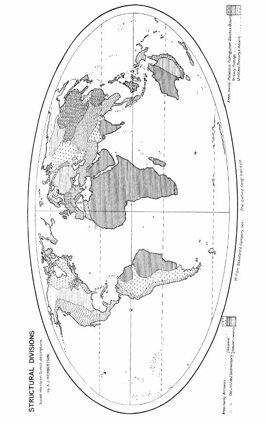
The feature lines of both the high and low lands are varied, and depend in the first place on the structure of the crust. The accompanying morphological map is based mainly on Suess's classical work.
(1) The Pacific and Mid-World belts of lofty land coincide with the areas where the roclrs of all ages have been folded into parallel ridge and furrow-the y o l r ~ ~ g The continuity is modified here and there by great lava, folded mountains. flows and volcanic cones, or by raising or lowering of great blocks as a whole. The general features are all drawn out in the direction of the belts, which we might describe as the crests of major waves, of complex undulating character, bordered by
:I04 THE MAJOR NATURAL REGIONS: AN ESSAY IN SYSTEMATIC GEOGRAPHY
two major troughs, the one deeper than the other. Cf.the Chilean deeps and the Paraguay plains.
( 2 ) The intermediate heights are of two types. I n both there are raised blocks bordered by sunken areas, the chief margins being determined by fractures, while the drainage systems are of great importance in shaping the superficial features. In one type the palaozoic rocks are folded, but not the younger ones. These we may term denudution 7~igl~lands, because the main feature lines other than those determined by fractures are due to superficial erosion, which may, as in the Llppalachians, or may not, as in the Central European Highlands, bring out very clearly the lines of crustal folding. The parallelism of ridge and furrow is on the whole rarely well marked. Young volcanic rocks are found along the marginal fractures both in this and in the next type.
(3) In the other type, even the oldest sedimentary rocks lie almost horieon- tally, with flexures only here and there, and form vast tabl1,7ut~ds. The fcaturc lines of these tablelands, where not detcnnined by fracture, are liver-vallcyb, which as a lule are steep-sided gorges-at least in tllc early phase of denudation.
(4) The ZowZai~ds consist of reduced forms of types 2 and 3, and, in addition, areas covered with recent deposits either of terrestrial or marine origin. These wc distinguish as denudatiofz pkailzs, tubular p7ains or platjorrns, and accz~~iiz~latiorc plains.
The study of these types-young folded mountains, tablelands and platforms, denudation highlands and plains, and elevated and lower accumulation lands- suffices to give an idea of the main feature-lines of the lands of the globe. There is a very large number of varieties, partly due to the relative importance of fracturing and folding in a given area, partly to thc nature of the transforming agents a t work-ice, running water, or dry air. To the clistribution of these pro- cesses the rainfall map is a key, and for the secondary division of land forms, a superposition of the orographical, tectonic, and rainfall maps is necesbary. The rainfall map is important in other connections, and this leads to the consideration of the distribution of climatic forms.
Climate.
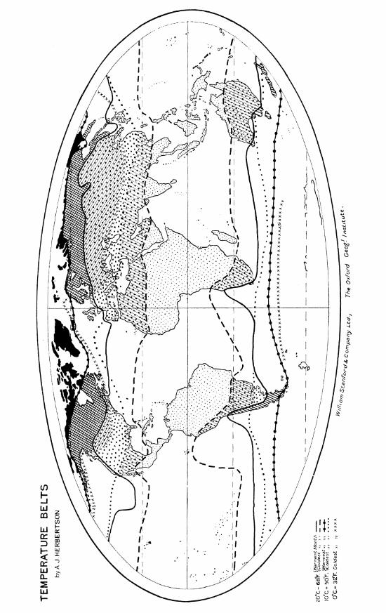
While the pressure and wind map is the key to many climatic peculiarities, for our present purpose the temperature and rainfall m a p are of the greatest importance.
The isotherms available of most geographical iml~ortance are those of XO,SO0, and tibo Pahr. (0'. lo0, and 20' C.) in the coldest, and 50' and 6 8 O Fahr. (10' and 20' C.) for the warmest months, that for 60' Fahr. (10' C.) in the warmest month being perhaps the most significant. They indicate the succession of tempetaturc belts, each with its own characteristics. These belte, as the map shows, are, owing to winds and ocean currents, narrowest in low latitudes in the west, and in the higher latitudes in the east of the continents. I n thesc narrow parts the temperature conditions vary most within unit horizontal distance, whereas on the opposite sides of the continents they vary least. There is a contrast between the temperature conditions of east and west. This is part of the general climatic difference between east and west, which is of fundamental importance.
Rainfall maps are of even greater significance. The rainy season, as well as the quantity of rain, must be taken into account. A new map showing seasonal rainfall, based on Supan's seasonal rainfall maps, accompanies- this paper. This permits the differentiation of regions which receive sufficient rainfall a t none or one or more seasons, and the comparison between those regions where the rainfall is precipitated when temperature conditions are most and least favourablc.
306 THE MAJOR NATURAL XEGIONS: AN ESSAY IN SYSTEMATIC GEOGRAPHY.
The first contrast is between the drier interior and the wetter coast ; the second, between the drier lowland and wetter highland ;the third, between the east and west coasts. On the east coast most coastal lands receive a fair supply of rain from equator to polar circles, but in the west, dry areas extend from the coast far inland around each tropic on the lee aide of the lands in the trade wind belts. The temperate coastal lands receive most rain in winter, but nearly all other parts of the world receive most in summer. The northward and southward movement of the wind-belts determines areas on each side of the tropical deserts-the equatorial one with a summer rainy season, the polar one with a winter rainy season.
Combining these, we have the following climatic regions :-(1) Polar, where the temperature is never high and the rainfall always low,
most falling in the summer. (2) The cool temperate belt, with (a) a rainy west coast ; and ( h ) a less rainy
east coast-both with rain at all seasons, the maximum falling in autumn or winter; and (c) an internal area of great extremes of temperature, ancl a low and early summer rainfall.
(3) The warm temperate belt, with (a) winter rains in the west; and (b) summer rains in the east. (c) The intermediate internal region, where it occurs, is one of great extremes of temperature and low rainfall, especially where moun- tainous.
(4) The western tropical deserts, with great ranges of temperature, and little cr no rainfall.
( 5 ) The inter-tropical regions, with one rainy season in summer. (6) The equatorial rainy areas, with two relatively drier periods. 'I'he mountain areas partly help to define the limits of these regions, and partly
introduce zones with successively colder climates and, up to a certain level, with wetter ones.
I t will be seen from the map that most of these regions occur tmo or three times in each zone, and accordingly give the data for valuable comparisons.
Vegetation. In its main outlines the vegetation map follows the climate map, and only in
its secondary characteristics does it show the effects of the soil and drainage. If the existing plant-covering of the Earth is mapped, then the influence of man is a third factor, which in most botanic maps is eliminated. The vegetation map may be looked upon as a commentary on and a summary of the climatic ones.
Density of Poptelation. The mapping of human conditions has less significance in indicating the
natural geographical regions, for the factor of human development has to be taken into account as well as the possibilities of the natural environment. The density of population map is the most direct expression of the actual economic utilization of the natural region. One has only to cite the central plains of Eor th America before and after the introduction of railroads and the exploitation of minerals, to measure the importance of the human factor in determining this density. Each geographical region has its potentialities as well as its actualities, and a study of these is one of the most complex and fascinating the geographer can tacltle. The necessary preliminary, however, is a just appreciation of the natural physical condithns of relief and climate.
Hitherto i t has been customary to study the geography of the World according to political divisions. These, expressing the most complex and comparatively unstable of human conditions, must be eliminated from any consideration of natural regions.

SEASONAL RAINFALL ;~r ,ng y<-'Aurnmer
-- -~
G!r,che: , o f R r ~ ~ r , f a I /

I n the determination of natural regions, climate and configuration nus st both be concidercd. Climate, because i t not merely affects the physical features, bllt also because i t best summarizes the various influences acting on the surface. Climate even more than configuration, for the great barriers of the lands are climatic- wastes of arid desert or ice mountains-for i t is the climate more than the con- figuration wliich renders lofty mountains effective b3r1-iers. Only when minor forms are taken into consideration does configuratioo become the all-impoltant factor. On the accompanying map I have ventured to outline the regions which the consideration of all factors seems to me to determine.
A natural region should have a certain unity of configuration, climate, and vegetation. The ideal boundaries are the dissociating ocean, the severing mass of mountains, or the inhospitable deserts. As a rule, save in the case of the shore, the boundary is not at all well marked, but the characteristics of one region melt gradually into those of another. l'remising that the lines on the map are taken as the approximate central lines of the transition areas, we may divide the world up into the following types of natural regions:-
1. Polar. (a) 1,owlands (Tundra type); ( h ) Highlands (Ice-cap type). !L The cool temperate regions. (a) \vestern margin (West European type) ; ( b )
Eastern margin (Quebec type) ; (c) Interior lowlands (Siberian type) ; ( 1 7 ) Interior mountain area (Altai type).
3. The warm temperate regions. (a)Western margin with vinter rains (AIediterranean type) ; ( h ) The eastern margin with summer rains (Cliina type); (c) The interior lowlands (Turnn type) ; (.I)and the plateau (Iran type).
4. ( 1 6 ) The west tropical deserts (Sahara type) ; (b) East tropical lands (Monsoon type) ; (c) Inter-tropical tablelands (Sudan type).
5. Lofty tropical or sub-tropical mou~ ta ins (Tibetan type). 6. Equatorial lowlands (Amazon typej. The importance of regarding the Earth in this way can hnrdly be over-
estimated. Take, for instance, the application to education. lcnoming each of the chief types, it is a simple matter to learn the peculiarities of each variety, and a great saving of time is effected, while the intellectual discipline of distinguish- ing thc species and comparing the varieties is great. The application t o economic and political affairs is even more obvious. Speaking generally, the permanent elements of each region are similar, and the history of the exploitation of the variety of any type o f region where human development is most-advanced should be of areat profit to those interested in the ev~loitation or aduinistration of the
A- . . relatively undeveloped varieties of the seine type. The recognition of natural regions gives the historian a geographical foundatio~l for his investigations into the development of human society, such as he has not hitherto consciously possessed. By comparing the histories of the same race in t w o different regions, or of a succession of races in the same region, i t should be possible to arrive at some knowledge of the invariable effect of a type of environment on its inhabitants, and permit some estimation of the non-environmental factors in human development. I t would be difficult to exaggerate the importance of this investigation, which seems to me a fundamental one for all who have to deal with the study of man, or with his economic exploitation or his proper government.
No one is better aware than I of the incompleteness of the present communica- tion, but I vonture to make it, in the hope that i t may atart criticism, and ultimately lead to a better understanding of one part of geography, and of i ts practical as well as its theoretical importance.
No. III .-~12i~c~,1905.1
THE MAJOR NATURAL REGIONS: AX ESSAY IN SYSTEJIATIC GEOGRAPIIT.
I n future papers I propose to deal in some detail with a c h t j p e uf u:tlural region and its varieties.
After the reading of the papcr, the following discussio~i tool; place :-Dr. a111I,: I am much interested in this attempt of Mr. Hcrbertson's to
introduce something more systematic into the classification of natural regions, but I have hardly given the subject sufficient attention to justify me in opening the discussion upon it. My own views on systematic geography I have already elaborated rand set forth to the beat of my ability in my address to the British Association in 1'301. I should lilie to ask Slr. Herbertson for what purposes he proposes to use those natural regions ? they to take the place of the old division of the world into continents, or are they to be used for such discussions as arc concerned with the distribution of climatic and botanical phenomena ?
Dr. Hxnnr . :~~sox : The continents would be as a t present. This is a crow-division trying to conslcler all the factors, clas~ifying tlic natural regions of each continent, by means of which me can connect one continent with another, such as Europe and Asia, or Africa and South America.
Dr. MILT.: Understanding that, I am confronted nit11 this very seriou5 difficulty. T1711atever one of the many distributions we consider, we sliall find that if there is a c1assific:~tion possible with regard to it, i t mill in some rcspects run counter to the classification required for the consideration of other phenomena, and i t is quite impossible, as I know from an attempt that was made, to get a classifica- tion of the world in natural regions that would satisfy the ~rorkcrs in several branchcs of science. Tile oilly class~fication equally suited for all purposes i i tha t of coast-lines acd degree-net. And my feeling is, the more general we can make the physical classification the better. I do not think wc require to go beyond the purely orographical. It seems to rile that the science of geoyraphy has to do essentially with the action and reaction of the configuration of the Earth upon the rnany mobile distributions, and tha t one elassificatio~~or anothcr classification may be appropriately adopted when we consider one or ailother of these conditions. But my feeling is that for the general purposr we shoultl stick to the dcgree-net, the coast-line, and the contour-lines, which are necessary and suffi~ient. That appears to m y ininci to u e e t thc co~ltention tha t such larger subdivisio~l is necessary, ant1 I fcnr that as our kno\.ilcdgc of cli~llatc advances, the lines dividing areas will bc continually modified. I rcmember olicc trying to draw a map of Africa treating of the relative clin~atcs, t a k ~ n g into account all the conditions, altitude, latitude, prevailing winds. etc., and :t mas :nost difficult and very unsatisfactory. TVe must have inore li~lowledge tllan we no\v possess before such a map could be drawn ; ultimately i t might be possible. But it is desirable that an and widen attempt should be made to extend our kno\~~lecige our grasp of the inter-relation of phenomena, and in that direction I think t h i ~ paper of Mr. Herbertson's is extremely suggestive and most valuable, and I am quite sure that if i t is further considered and published with the maps ~vhich have been exhibited, i t will exercise a very considerable influence in promoting interest i n geographic31 science.
Mr. l l o u a ~ a s FRESHFIELD RIill has already said all, or almost all, : Dr. Chat I should care to say very much bettcr than I could have said it. It seems to me tha t t l i ~ s attempt to create what I thinlr Mr. I-Ierbertson called in 111s paper genera In regions is a very difficult one. Tou rvill only get your genera by d~sregarding certain points in which regions differ. It may be an inetructi~e inquiry, but I am rather doubtful as to its usefulness in teaching. I am afraid that as we g r o r more and more scientific we are liable to nlix up geography with every