the murrindindi fire 10royalcommission.vic.gov.au/finaldocuments/volume-1/pf/...145 the murrindindi...
TRANSCRIPT
10THE MURRINDINDI FIRE

Volume I: The Fires and the Fire-Related Deaths
144
Murrindindi is a small settlement in the Shire of Murrindindi, approximately 100 kilometres north-east of Melbourne.
The Murrindindi fire started at about 14:55 on 7 February 2009, to the north of a sawmill in Wilhelmina Falls Road, Murrindindi. It travelled rapidly and by 16:30 was affecting Narbethong.1 Following a wind change that arrived at about 18:15, the fire swept through the communities of Marysville, Buxton and Taggerty. It continued to burn for weeks in heavily forested public land and was not formally declared contained until 5 March. By this time the Kilmore East and Murrindindi fires, which had merged, had burnt 168,542 hectares and, among other things, threatened Melbourne’s water catchments.2
The fire resulted in the deaths of 40 people, and more than 500 houses were destroyed or damaged, mainly in and around Marysville, Narbethong and Buxton. The commercial centre of Marysville was destroyed, as was the core of the town’s economic activity in tourism and hospitality. Much of the town’s public infrastructure—including the police station, primary school, kindergarten and health clinic—was also destroyed.
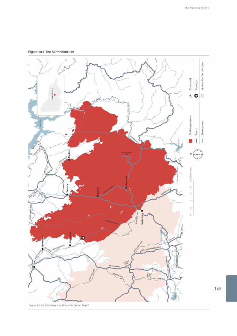
Figure 10.1 shows the extent of the fire.
Overview
Maximum temperature The maximum temperature recorded was 44.6°C at Coldstream automatic weather station at 17:34.3
Minimum relative humidity The minimum relative humidity recorded was 8 per cent at Coldstream AWS at 17:28.4
Wind The maximum wind recorded before the wind change was a north-north-easterly at 46 kilometres an hour at Coldstream AWS at 13:00.5
The wind change was recorded at 52 kilometres an hour at Coldstream AWS at 17:48.6
The maximum wind recorded after the wind change was a south-westerly at 57 kilometres an hour at Coldstream AWS at 17:51.7
Fire danger index The maximum Forest Fire Danger Index was 110 at Coldstream AWS at 13:00.8
Cause Suspicious.9
Fatalities Forty fatalities.10
Casualties Seventy-three casualties.11
Houses destroyed 538 houses.12
Overall area burnt The combined area burnt by the Murrindindi and Kilmore East fires was 168,542 hectares.13
Firefighting resources On 7 February, 195 CFA and 311 NEO personnel attended the fire. They were supported by 45 CFA appliances, 22 NEO appliances and 3 aircraft.14
10 THe Murrindindi Fire
145
The Murrindindi fire
Figure 10.1 The Murrindindi fire
Source: Exhibit 994 – Murrindindi Fire – Fire Spread Map.15
Up
per
Yar
ra R
eser
voir
Lake
Eild
on
O’S
hann
assy
Res
ervo
ir
Mar
oo
ndah
Res
ervo
ir
Sug
arlo
af R
eser
voir
Ma
rysv
ille
Na
rbe
tho
ng
Bu
xto
n
Tag
ge
rty
Mu
rrin
din
di
Ye
a
Lim
est
on
e
Ru
bic
on
NFi
nal f
ire p
erim
eter
Roa
ds
Riv
ers/
cree
ks
Fire
sp
read
Fire
orig
in
Kilm
ore
Eas
t fir
e p
erim
eter
Mur
rind
ind
i
BIG RIVER ROAD
LAKE MOUNTAIN ROAD
BREAKAWAY ROAD
WH
ANRE
GAR
WEN
RO
AD
MOUNT PLEASANT
ROAD
SKYLIN
E ROAD
RUBICON ROAD
MARYSVILLE ROAD
LANGS ROAD
MURRINDINDI ROAD
LIM
ESTO
NE R
OAD
MYE
RS C
REEK
ROAD
CASTELLA
ROAD
MELBA HIGHWAY
GLENBURN ROAD
BREA
K OD
AY R
OAD
HEA
LESV
ILLE
-YAR
RA G
LEN
RO
AD
DON ROAD
MAR
OO
ND
AH H
IGH
WAY
HEALESVILLE-KINGLAKE ROAD
STEELS CREEK ROAD
PIN
NAC
LELA
NE
PLAN
TATI
ON
RO
AD
ACHERON WAY
BLACK RANGE ROAD
05
2.5
7.5
1012
.5K
ilom
etre
s

Volume I: The Fires and the Fire-Related Deaths
146
14:55 16:10 17:00 18:3516:3015:17
Murrindindi fire starts to north of Murrindindi Mill
Alexandra ICC takes control
VICSES evacuation of Marysville
Fire moves through Marysville
South-westerly wind change moves through Taggerty
18:30DSE and CFA arrive at Kings Road spot fire
Back-burn lit to control Kings Road spot fire
Police warn residents of Marysville
17:05MECC established
18:35South-westerly wind change moves through Marysville
16:15Fire reaches crest of the Black Range, 12 kilometres from point of origin
15:00Toolangi DSE crew responds
Toolangi crew leader arrives
Fire approximately 40 hectares
16:20Two fixed-wing water bombers make first drops
18:15South-westerly wind change moves through Narbethong
Convoy of residents and police leave Gallipoli Park oval
18:20Spot fire begins near intersection of Kings Road and Martin Road
16:30Spot fires ignite in and around Granton, St Fillans, Mt Ground and Maroondah Highway
Fire affecting Narbethong
Murrindindi
The following time line summarises events associated with the Murrindindi fire. For the most part, the times given are approximate. Further details about the events are provided in the accompanying narrative.
19:1519:007 February
7 February – 7 March

147
The Murrindindi fire
Fire reaches Buxton
Murrindindi and Flowerdale tankers recalled to Yea MECC closed
20:20Alexandra crew fall back from Buxton to Taggerty
20:35Most DSE crews fall back to Alexandra to protect town
Fire south of Taggerty
Road to Taggerty cleared for ambulance access to Marysville
Fire contained
02:3019:30 20:00 22:00 8 February 5 March 7 March

Volume I: The Fires and the Fire-Related Deaths
148
10.1 Sequence OF evenTS
PreParaTiOn10.1.1
Mr Peter Farrell, Department of Sustainability and Environment Land and Fire Manager for the North-East Area, participated in the Chief Fire Officer’s briefing on 5 February. In the days leading up to 7 February he directed staff at Benalla ‘to start compiling teams of available people to undertake both incident management roles and also on ground firefighting roles’ to provide for the staffing of incident control centres in the region. He did not, however, ‘look at the detail of who had been allocated to which control centre’ and relied on staff to give him advice on the availability of incident management team personnel.16
The Country Fire Authority’s preparation for 7 February was overseen by the CFA Region 12 Operations Manager, Mr Peter Creak. In the lead-up to 7 February he prepared an ‘incident management team planner’ that identified personnel available for deployment to either of the two incident control centres that had been designated level 3 ICCs in CFA Region 12 for that day—Kilmore and Alexandra. Although the names of DSE personnel appeared on the planner, there was little integration between the CFA and DSE in the establishment at Alexandra of a level 3 ICC. The Alexandra ICC was based at the DSE facility there and staffed by DSE officers. Mr Creak positioned level 2 ICC resources and facilities in the region, including at the Yea and Alexandra Group Centres.17
Alexandra was one of the seven level 3 ICCs in DSE’s North-East Area. It later became the ICC for the Murrindindi fire.18
To staff these facilities there were 16 level 3–accredited Incident Controllers across the North-East Area (two from DSE and 14 from the CFA). A further three (one from DSE and two from the CFA) were trained to perform a level 3 role but required mentoring. Five DSE and three CFA Incident Controllers were identified in Mr Creak’s planner as available to work the day shift on 7 February and could, if directed, have been at the Alexandra ICC. Not all of them, however, were qualified as level 3 Incident Controllers.19
The usual practice in Region 12 was to send the necessary staff to the activated ICCs when fire incidents demanded, rather than pre-position personnel in incident management teams. Mr Farrell was advised on 6 February that ‘all available key IMT staff were available’. He was satisfied that the rostered staff were appropriate for a level 1 or level 2 incident and that the local mutual aid plan provided for enough level 3 Incident Controllers, including those from the CFA, if the situation demanded it. This arrangement differed from that in other regions, where fully formed level 3 IMTs were positioned in response to the Chief Officers’ requests for a ‘hot start’.20
Sergeant David Rowles, the Municipal Emergency Response Coordinator, and Mr Ian Ellett, the Municipal Emergency Resource Officer, prepared for 7 February by notifying key personnel so as to ensure they were contactable and on standby to activate the municipal emergency coordination centre and by placing council equipment, including a large water tanker and grader, on standby for the CFA.21
Table 10.1 summarises the state of preparedness for the Murrindindi fire.
Table 10.1 The Murrindindi fire – iMT preparedness
Pre-designated level 3 iCC Yes22
Pre-formed iMT at iCC Yes but incomplete23
Pre-identified level 3 iC None specific to that ICC24
Pre-identified iMT members Yes but deficient25
Time fire started 14:5526
Full iMT in place by 8 February27
Safety adviser appointed No28
149
The Murrindindi fire
7 February 10.1.2
Before the Murrindindi fire was reported the Alexandra IMT was already depleted because a number of staff members—including a level 2 mapping officer, two level 3 situation officers, five level 2 operations officers and a level 3 information officer—had been sent to help deal with the Kilmore East and Bunyip fires.29
At 12:00 only one level 1 Incident Controller, one level 1 and one level 2 operations officer, one level 3 planning and one level 3 logistics officer, and one air attack supervisor were at the Alexandra ICC.30
Origin and cause
At 14:55 Mr Colin Hind, the DSE fire tower operator at Mt Despair, saw smoke about 5 kilometres north-north-west of the sawmill in Wilhelmina Falls Road. He saw the fire move quickly to the south along the western side of the road and alerted the CFA and DSE. He told Ms Janice Joyce, the Glenburn CFA communications officer, ‘I have a fire at the old mill in Murrindindi. Get everything you’ve got to throw at this.’31
Police investigations determined the cause of the Murrindindi fire to be suspicious.32 In order that criminal investigations and proceedings not be prejudiced, the Commission heard no evidence about the cause of the fire.
initial fire run, response and management
Fanned by a strong north-north-westerly wind, the fire spread quickly through grassed paddocks, entered a privately owned blue-gum plantation to the south of the sawmill, and moved rapidly into Toolangi State Forest. It reportedly travelled 2 kilometres in about five minutes.33
CFA resources from the Yea Group were the first to arrive at 15:08. DSE also deployed all available local resources that had not been sent to the Kilmore East fire. Some crews were delayed because they had to take indirect routes in order to avoid roads affected by fire. The initial attack on the fire involved one tanker, two slip-on units and one first-attack bulldozer.34
This initial response was managed by the CFA. Mr David Webb Ware, captain of the Glenburn brigade, initially assumed control and contacted the Yea Group headquarters. From that time until control passed to the Alexandra ICC, Mr Neil Beer, the Yea Group Officer, was the Incident Controller. In charge of a level 2 ICC at the CFA’s Yea Group headquarters, he oversaw the subsequent response, established a staging area and sectorised the fire.35
DSE resources and personnel were concurrently being directed from Alexandra to the fire. There was no integration of DSE and CFA resources and personnel during the initial attack.36
initial warnings and informationbox 10.1 The Toolangi DSe crew
The Toolangi DSE crew independently responded to the fire at 15:00, with Mr Mike Lauder, a senior ranger for DSE, as crew leader. By the time the crew arrived, at 15:17, the fire was well alight, had burnt about 40 hectares, and was too large for first attack to be contemplated.37
Under Mr Lauder’s direction, the crew travelled in convoy from the fire’s point of origin to Murrindindi scenic reserve. He knew people were camping there. Not long after arriving, Mr Lauder realised that they—the crew and the 19 campers—were cut off to the north by the fire and were trapped. He directed crew and campers into the river, about 150 metres away. The children sheltered in the DSE vehicles in the river. The crew protected the campers for the next hour-and-a-half. The pumps on the slip-on units were used to spray water on both the vehicles and the surrounding vegetation. No-one was injured, although some campers and crew members suffered from smoke inhalation and were later treated by ambulance officers. One crew member spent the night in hospital.38
The Commission commends the Toolangi crew for its initiative and for protecting the campers.

Volume I: The Fires and the Fire-Related Deaths
150
For the first two hours of the fire there was no information officer at the Alexandra ICC, so the first official warnings were prepared and distributed by the Benalla Integrated Fire Agency Coordination Centre.39
The Alexandra CFA Group was in a building separate from the designated ICC. It contacted community radio station UGFM shortly after 15:00, advising that a fire had broken out at the Murrindindi Mill. UGFM began broadcasting warnings about the fire at 15:16. This was the first of many warnings the station issued. UGFM often transmitted well ahead of warnings broadcast on 774 ABC radio and through the CFA website, despite not being part of the official distribution list and relying heavily on local connections and knowledge.40
Mr Andy Willans, Mt Gordon fire tower observer, began watching the fire soon after it ignited. By 15:30 he had no doubt that Marysville was at risk, but he was unable to communicate his observations to the incident management team until about 16:00 due to congestion on radio channels and phone lines. He evacuated the tower at about 16:30 for his own safety and returned home to defend his property. The tower was badly damaged in the fire.41
He gave a dramatic account of the fire.
In that first half hour, from a tiny little trundle of smoke that I spotted and was able to give a bearing to, it grew in such incredible stature. I’d seen nothing like it. It terrified me. In the next half hour to when it breached the Black Range Road, I guess it would have doubled the amount of smoke, its height, its width. It was enormous. The following half hour until I left it was massive. It’s beyond description. This thing was huge, absolutely huge. I can’t explain it. And it was alive. This thing was just full of ember, ash, burning materials. This thing was absolutely alive.42
Mr Peter Cobb, a Marysville ranger and a crew leader for DSE, made a number of observations about the location of spot fires and the behaviour of the main fire between 16:00 and 17:00. Mr Willans quite rightly commended Mr Cobb for his bravery in making these observations from the fire ground. The incident control centre, however, was unaware of Mr Cobb’s observations, and it is not clear to the Commission to whom Mr Cobb was reporting.43 As detailed later in this chapter, the failure of the incident management team to better use these and other sources of information compromised planning and warnings to local communities and firefighters.
Subsequent fire run and response
After entering Toolangi State Forest the fire rapidly increased in intensity and developed a large convection column. It crowned almost immediately, and fire activity was reported as ‘very, very intense’ with flames up to 20 metres high.44
DSE and Murrindindi Shire personnel deployed additional bulldozers and graders to construct control lines. DSE ground crews were deployed to communities to the east and west of the Black Range. All crews concentrated on community and asset protection.45
Early assessments were that the fire would burn largely in forested areas, so DSE was appointed control agency. The DSE Incident Management Team based at the Alexandra ICC, about 40 kilometres north of Marysville, took control of the fire at 16:15. No handover was, however, conducted between the level 2 IMT at the CFA Yea Group headquarters and the level 3 Alexandra IMT. During subsequent confusion about which IMT was managing the fire, CFA crew on the ground continued to report to Mr Beer at Yea.46
Mr Andrew Miller, a Parks Victoria employee who was the local duty officer on 7 February, assumed the role of Incident Controller when the fire started. Although he held only level 1 qualifications as an Incident Controller, it was the usual practice in DSE at that time for the duty officer to assume the role of Incident Controller for first attack. Mr Miller’s incident control experience was, however, limited, to ‘some responsibilities’ as a level 1 Incident Controller and ‘a couple of short stints in what was probably a level 2 incident’. He was less qualified and less experienced than Mr Peter Rice, the CFA Alexandra Group Officer, who was a level 3 Incident Controller also in Alexandra but in the building that was the CFA Group Office, a short distance from the Alexandra ICC.47
The fire moved rapidly to the south-east at about 11 kilometres an hour; it was a rolling ground and crown fire producing spot fires to the south and east of the main front. It burned up the western slopes of the Black Range, a ridge running north–south at 700 to 800 metres above sea level. Adjacent is the Acheron River valley, which runs from Narbethong in the south through Buxton to Taggerty in the north, on the eastern side of the range.48
151
The Murrindindi fire
On its initial run the Murrindindi fire burned through public forested land of mainly very tall, mature mountain and alpine ash, with mixed species, including wattles, at lower elevations. These forests are typically moist, but by the end of January 2009 they were as ‘dry as a chip’, as Mr Lauder put it. They also carried a very high fuel load—up to 50 tonnes a hectare. Ash trees have long ribbons of bark that hang loosely from their trunk and branches; these are easily ignited and can be transported long distances by a convection column, causing spot fires ahead of the main fire.49
initial police and municipal support
At about 16:00 Inspector Ross Smith, Manager of the Mitchell–Murrindindi Police Service Area and Forward Commander for the Kilmore East fire, contacted Sergeant Rowles, telling him there was a fire at the Murrindindi Mill and recommending that he begin his duties as Municipal Emergency Response Coordinator and activate the Municipal Emergency Coordination Centre. Sergeant Rowles contacted one of the Deputy Municipal Emergency Resource Officers, Mr Mark Leitinger, and asked him to open the MECC. He also contacted Mr Miller, the Incident Controller.50
People started arriving to activate the MECC soon after 16:00. It was still being set up when Sergeant Rowles arrived at 17:05.51
From the time the MECC was open it received a constant flow of telephone calls and inquiries from organisations, agencies and the public. The logs kept for the MERC, the MERO and the MECC show that only a small proportion of the requests received on 7 February were requests for resources. Sergeant Rowles received many requests that were outside the scope of his coordination role as MERC—for example, police operational calls to establish roadblocks. Mr Ian Ellett, the MERO for Murrindindi Shire, observed that many requests came directly from agencies such as the CFA, Victoria Police and Victoria State Emergency Service, rather than from the relevant ICC. In the week following the fire, a large number of requests were received directly from residents of Murrindindi Shire and from the general community.52
The information flow from the ICC to the MECC was limited, especially in the early stages of the response on 7 February. Sergeant Rowles stated, ‘The CFA Liaison Officer did everything he could to find out where the fire was heading but was only able to supply me with very limited information’.53
The black range
At about 16:15 the fire reached the top of the Black Range, 12 kilometres from its point of origin. The strong north-north-westerly winds launched it from the top of the range, propelling burning bark, leaves and branches up to 15 kilometres to the south-east. This intense fire burning through extremely dry forest, combined with the weather conditions and the topography, created ideal conditions for spotting.54
At 16:20 Mr Peter Weeks of radio UGFM received a telephone call from his partner, Ms Judy Blakeney, who was working in the Alexandra ICC. She told him they were receiving reports of ember attack at Narbethong and Buxton. Mr Miller then spoke with Mr Weeks and confirmed that he could broadcast that information on UGFM. Mr Weeks told listeners the fire was burning into the Black Range and was heading towards Narbethong, on the other side of the range.55
Burning debris ignited spot fires up to 15 kilometres ahead of the main firefront, in and around Granton, Narbethong, St Fillans, Mt Gordon and the Maroondah Highway at about 16:30. The hundreds of spot fires that started within a kilometre of the firefront were quickly drawn back into the main fire by the convection column. Spot fires that started between 1 and 10 kilometres from the main firefront spread independently for a time before being drawn back into the main fire. The spot fires even further away behaved independently of the main fire for considerable periods, and some became so large they created a second wave of spot fires further to the south-east.56
New fires that had been created by spotting and were moving towards the Marysville area hampered fire crews, who continued to work on asset protection under these extremely difficult conditions.57
At 16:31 UGFM broadcast an interview with Mr Rice, who warned residents in the Buxton area, down to Narbethong and back to the south side of Acheron to be aware of the fire. At 16:37 the UGFM announcer reiterated that the Murrindindi Mill fire was burning along the Black Range and could impinge on Narbethong, Taggerty and Buxton.58

Volume I: The Fires and the Fire-Related Deaths
152
At 16:47 an urgent threat message for the township of Narbethong was read on 774 ABC radio; the message was posted to the CFA website at 16:55 and repeated at 17:10. 774 ABC radio interviewed Mr Greg Esnouf of the CFA at 17:25; he mentioned the Murrindindi fire but did not identify any communities as being under threat.59
DSE monitored the fire from the air. Mr Shaun Lawlor, who was based at the DSE’s Ovens office, was called on to perform the role of air attack supervisor at about 15:30. He arrived over the fire’s point of origin at about 16:50. By this time two fixed-wing bombers had already dropped retardant over the Narbethong area and were returning to Mansfield for reloading. Mr Lawlor asked one plane to continue with this work and the other to make a drop east of a spot fire that had started 500 metres west of Mt Gordon. He watched as this was done and concluded it was ineffective. He explained, ‘The retardant normally drops to tree level and penetrates the canopy, covering the surface and surface fuels, which in turn impedes the progress of the fire’. On this occasion, however, ‘the retardant dispersed and blew away before reaching the tree canopy level due to the strength of the wind’. Mr Lawlor decided the operation was not only ineffective but also unsafe, and he directed the planes to return to base and await further instructions.60
The two planes were operating in extreme conditions. On arriving back at the air base, one of the pilots discovered that his emergency locator transmitter had been activated on his last drop. (An emergency locator transmitter usually activates in the event of a crash, to send out a signal to help search and rescue crews find the aircraft.) It appears the transmitter had activated because the turbulence the aircraft was experiencing resembled the impact of a crash.61
Mr Lawlor went on a reconnaissance flight over Narbethong and Marysville shortly after 16:50.62 He described what he told Mr William Twitchett, deputy operations officer, at about 17:10:
I advised Bill that there was a small spot fire approximately 500 metres to the west of Mt Gordon fire tower and that it was unsafe to send crews into that area. I confirmed that Narbethong was under direct attack and that there was also … between the Marysville log dump and the adjoining trout farm [a spot fire] which was becoming quite active. I also advised Bill that Marysville and Buxton were not being impacted by the fire but that if the predicted south west wind change occurred they would be directly in the path of the new fire front. At this time the main fire front was extremely active and located seven to ten kilometres south of Marysville in the vicinity of Mt Strickland.63
The information Mr Lawlor provided, in combination with the observations of Mr Willans and Mr Cobb, could have provided a reasonably complete picture of the fire’s behaviour and its potential impact had it been collated and analysed by the incident management team long before the fire reached Marysville.
Situation officer Mr John Steer was asked at 16:55 to ‘check the weather front and prepare a Situation Report’, but he did not seek a local weather forecast until after the wind had changed. Although Mr Steer was familiar with local weather forecasts and had used them before, he told the Commission he had not ‘previously sought a spot weather forecast so early in a fire’. His experience was limited to using local weather forecasts when preparing incident action plans for the following day.64 This failure to ask for a local weather forecast was to become crucial because the incident management team did not have to hand accurate information about local weather conditions on which to base warnings for firefighters and communities potentially in the path of the fire.
At 17:00 an information officer arrived at the Alexandra ICC. Despite this, warnings continued to be relayed to the Benalla Integrated Fire Agency Coordination Centre for distribution.65
At 17:11 radio UGFM broadcast an urgent bushfire information alert for Marysville:
… there is spotting occurring in quite a lot of places to the west of the Mt Gordon Tower and also around the trout farm just near Mt Gordon. Now that means it’s getting very close to the Marysville area so residents of the Marysville area […] I would be very … This is unofficial I must say to you but residents in the Marysville area should enact their bushfire plan I would think at this point in time.66
This was the first warning broadcast for residents of Marysville. It was based on information conveyed to Mr Weeks of UGFM by Ms Blakeney in the Alexandra ICC. Soon after that broadcast UGFM’s main transmitter site lost power, and the station was off air until 17:49.67

153
The Murrindindi fire
Shortly before 17:00 Mr Rice deployed a number of CFA crews to Buxton, Taggerty and Narbethong.68
Mr Lawlor continued flying in the area of Narbethong, Buxton and Marysville to gather intelligence on the fire’s location and behaviour. At about 17:30, as he and his pilot were trying to fly directly over Marysville, the helicopter began an unplanned descent and it took some time for the pilot to regain control and ascend. Mr Lawlor and his pilot concluded that the unplanned descent was caused by the fire drawing so much air from the surrounding area that the air density decreased, compromising the operation of the helicopter. They remained in the air, however, monitoring the fire’s location and behaviour near Marysville until around 17:45, when they returned to refuel.69 The Commission commends the efforts of the pilot and Mr Lawlor, who, in extreme conditions, continued to monitor the fire in order to provide real-time information about what was happening.
evacuation
The State Emergency Response Plan provides that the decision to recommend the evacuation or relocation of people rests with the Incident Controller.70 In accordance with agency practice, though, the incident management team did not consider evacuation of any towns or localities affected by the Murrindindi fire.
Nor did firefighters on the ground consider evacuating Marysville. Many residents of Marysville and Buxton did, however, make the decision to leave in advance of the fire. Mr Glen Fiske, the Marysville CFA captain, provided advice in keeping with the CFA’s policy on evacuation during bushfires. At 7 February 2009 that policy precluded CFA personnel from advising residents whether to stay or go or providing specific advice to leave in the event of a bushfire. When asked for advice, Mr Fiske told people it was their decision whether to stay or go, but if they were leaving they should use the Buxton–Marysville road.71
By this stage many people were preparing to leave Marysville and Buxton. Between 16:30 and 17:00 Ms Josephine Hunter, Deputy Controller of the Marysville Victoria State Emergency Service, heard reports on the CFA radio that the fire had reached Narbethong. After consulting Mr Fiske and Mrs Pauline Harrow, a CFA communications officer, she decided to put the VICSES evacuation plan for Marysville into action. The plan contained a list of local people who might need help evacuating their homes in an emergency.72
After telling local police and VICSES she intended to implement the evacuation plan, Ms Hunter began telephoning the people on the evacuation list, advising them to gather at the Cumberland Hotel to be evacuated later if necessary. Two VICSES members drove to the retirement village and some of the other addresses on the list and urged people to enact their bushfire plan. People who were leaving were told to go to Alexandra. Those who wanted assistance with evacuation were told to go to the Cumberland and wait there for further instructions. All this activity was interrupted at about 17:45 by the need to free a local resident who had become trapped in her car by a fallen tree. By the time she had been released it was plain that Marysville was under direct threat. Ms Hunter and Mr Ian Bates, controller of Marysville VICSES, went to the Cumberland to evacuate anyone who was waiting there but found the place deserted. The owner of the hotel had already evacuated everyone who had gathered there to Alexandra.73
incident control
Once it had been determined that first attack had been unsuccessful, Mr Tony Lovick, an accredited level 2 Incident Controller, was appointed to replace Mr Miller as Incident Controller. He did not arrive at the Alexandra ICC until about 17:30, by which time the fire was out of control in the Black Range, had reached Narbethong and was threatening Marysville. DSE again did not appoint Mr Rice, the CFA-endorsed level 3 Incident Controller who was also in Alexandra, only a short distance from the Alexandra ICC. DSE did not appoint a level 3–accredited Incident Controller to manage the fire until the morning of 8 February, 16 hours after the fire had started.74 The Commission considers this delay in appointing a level 3 Incident Controller unacceptable.
At about 17:45 Mr Gregory Williamson, a CFA Divisional Commander in charge of all resources in Marysville, was told ‘there was to be a 50 to 60 kilometre an hour south-west wind change in about an hour and a half’. Mr Williamson told the Commission that before this time he had not been aware of a predicted wind change. During the next hour a number of other firefighters received information about the predicted wind change through red flag warnings issued not by the incident management team but by Group Officers Beer and Rice. In some cases, however, no predicted arrival time for the change was conveyed.75
Volume I: The Fires and the Fire-Related Deaths
154
A further urgent threat message for Narbethong, Marysville, Buxton and Healesville was issued at 17:45 and re-issued at about 18:15. There was no mention of the expected effect of the forecast south-westerly change. The messages were posted on the CFA website at 17:52 and 18:35 respectively. They were also read on 774 ABC at 18:10, 18:15 and 18:50.76
By 17:55 members of the incident management team were aware that residents of Marysville were taking refuge on the oval at Gallipoli Park. They did not consider providing protection for these people. Mr Lovick viewed the oval as quite a safe area; in any event, he regarded the deployment of resources at Marysville as a matter for Mr Williamson as Division Commander. But the IMT did not alert Mr Williamson to the gathering on the oval.77
The Kings road spot fire and back-burn
At 18:20 Mr Williamson became aware that a spot fire was burning near the intersection of Kings Road and Martin Road. After discussions with DSE crew leaders Mr Ben Giovanetti, Mr Peter Cobb and Mr James Cowell, he despatched two CFA strike teams (about 50 crew), 31 DSE crew and four crew leaders to the fire.78
By the time the DSE officers arrived at Kings Road, at about 18:30, the spot fire was burning about 100 metres from houses. The fire was between 20 and 30 metres in diameter and was burning towards the south-east. When the CFA crews arrived and assembled along Kings Road, Mr Williamson instructed them to help support the DSE officers protect houses with whatever water they had in their tankers. (Because of the high demand for water and the corresponding drop in water pressure, some parts of Marysville in higher elevations, including Kings Road, had no running water.) 79
Mr Williamson, Mr Cowell and Mr Cobb discussed lighting a back-burn between the northern edge of the spot fire and the southern boundary of Marysville, to ‘remove the fuel between the main fire and Marysville before the wind change … in case the main fire front were to reach Marysville’.80
Shortly afterwards the back-burn was lit along 250 metres of the southern track, to the west of the intersection of Martin Road and Kings Road. From that point Mr Williamson and Mr Giovanetti travelled in the direction of the reservoir.81
Although the Commission heard evidence that members of the incident management team were made aware that CFA and DSE crews intended to light a back-burn in Marysville, the crews did not receive the requisite Incident Controllers’ approval for such an undertaking. It appears that the IMT did not appreciate—and consequently did not inform those on the fire ground—that there was insufficient time to safely attempt the back-burn.82
evacuation of Marysville
Mr Weeks interviewed Mr Lovick on UGFM at 18:36. Mr Lovick referred to intensive spotting right through Buxton, Taggerty and Marysville and to the south-westerly wind change that was expected to reach the area at about 19:15.83
Not long after 18:30 a number of police officers who had just arrived in Marysville from Alexandra began driving around the town, using the police car siren to alert residents, informing them of the approaching fire and advising them to leave.84
Some of the police officers continued on to the oval at Gallipoli Park, where they found about 200 people with some 60 cars and other vehicles. It was widely understood in the community that the oval was to be a gathering point in an emergency. By the time the police reached the oval Marysville was engulfed in thick, dark smoke and trees next to the oval were on fire. The fire was roaring. The police officers realised there was a pressing need to evacuate and that there was very little time to do so.85 Senior Constable Ian Hamill recounted:
We drove into the centre of the crowd and I got out of the police vehicle and waved my arms above my head to try and gain the crowd’s attention. I yelled ‘Ladies and Gentlemen’ a couple of times and when I had everyone’s attention I told the crowd that we only had two or three minutes to leave. I said that the fire fighters were not able to reach us and that I needed everyone to stay calm. I then instructed everyone to get into their cars and drive in convoy to the Alexandra Secondary College which I knew to be the nominated refuge in town and which I also believed to be a safe location.86

155
The Murrindindi fire
Senior Constable Hamill was impressed by the calm response to his instruction: ‘Everyone just piled in, just one conga line, so to speak, and out the driveway they went’. One person who stayed at the oval and took shelter in a nearby lake saw the convoy leaving shortly before 19:00; he remarked, ‘The convoy left in an orderly fashion, the police did a good job there’.87
Another two police officers who had doorknocked at a few houses and driven along some streets sounding their siren arrived at the oval after the convoy had started to leave.88 Senior Constable Kenneth Dwight described the situation on the oval:
There was no protection on the oval and no fire trucks; we had no protection for anyone. If you had six trucks you could circle the wagons and put water up and protect them. But, with nothing, they all were just going to burst into flames. I have enough experience and knowledge of fire behaviour to know that if they stayed there they would all burst into flames eventually and there would be people running everywhere.89
The wind change
The south-westerly wind change moved through Narbethong between 18:15 and 18:45, through Marysville between 18:35 and 19:05, and through Taggerty between 19:15 and 19:45. By this time the fire had travelled 40 kilometres, with an average speed of nearly 11 kilometres an hour. The main firefront was almost 5 kilometres wide, and the fire’s north-eastern flank was 40 kilometres long. As the wind turned to the south-west, at about 35–45 kilometres an hour, the north-eastern flank of the fire became the main firefront. At this time the fire was near Marysville and, in addition to the existing spot fires, it began producing new spot fires in the forest on the town’s southern outskirts, in the town itself and to the town’s north. Protecting houses was hazardous.94
box 10.2 Case study: evacuation
Senior Constables Kenneth Dwight, Peter Collyer and Ian Hamill made the decision that evacuating the people gathered at the Gallipoli Park oval would be safer than allowing the people to stay there. They were confident that evacuation was possible because they had recently driven down the Buxton–Marysville road and it had been passable.90
Senior Constables Dwight, Collyer and Hamill, along with Senior Constable Andrew Walker, who directed the people on the oval to drive in convoy to Alexandra, had to make snap judgments using very limited information. They exercised initiative and sound judgment. Although acknowledging that this approach went against prevailing policy and that the evacuation was risky because the Buxton–Marysville road could have become blocked, the Commission commends the officers for their bravery and decisiveness. They made a controversial decision, but they made it with the safety of the public foremost in their minds and successfully delivered those involved to a safer place.91
Volunteers in two VICSES vehicles drove along the streets of Marysville trying to warn any residents remaining in the town. They used the vehicles’ public address system, calling out ‘SES Rescue, all vehicles evacuating Marysville are to head to Alexandra only’. When they reached the corner of Falls Road and Mount Kitchener Avenue, embers started coming in through the vehicles’ windows, and they decided it was too dangerous to stay. They went to the rear of the convoy, waiting as cars joined and advising people to keep going to Alexandra.92
As the convoy drove north along the Buxton–Marysville road the smoke cleared. The police and the VICSES personnel were able to warn many residents along that road and in Buxton of the approaching fire by going from door to door.93
The Commission commends the police and the VICSES volunteers involved in evacuating Marysville and Buxton for their courage and presence of mind.
Volume I: The Fires and the Fire-Related Deaths
156
Following the passage of the wind change through Narbethong, spot fires in the Narbethong area joined and burned towards Marysville.95
The wind change increased the fire’s intensity along its north-eastern flank, back as far as the point of origin. Fire crews working near the Murrindindi Mill saw the initial gusts of wind blow embers straight over the containment line to the north-east, placing the communities of Limestone and Murrindindi under threat for the first time.96
The arrival of the wind change also meant that embers were falling in Marysville. Mr Williamson gave the order for all crews working on the back-burn to retreat from Kings Road to the oval at Gallipoli Park.97 He told the Commission:
I now know that if I had not made this call to evacuate and if crews had not left at this time, we would have lost 60 to 70 people within 30 seconds to one minute later. Kit bags in the back of vehicles caught on fire due to ember attack and many of the DSE vehicles suffered damage to parts such as mirrors and plastic components which melted due to the intensity of the fire as the crews were driving towards the Marysville football oval.98
The Commission heard evidence about the danger to which firefighters in the vicinity of Kings Road were exposed.99 One of those firefighters, CFA Yarck brigade captain, Mr Thomas Jones, described the short drive down to Gallipoli Park:
It was pretty horrific. I ran off the road a couple of times. The smoke was that thick … you just could not—if anyone has been skiing up at Mount Buller or wherever in a white-out and if you have experienced that, that’s what it was like, except you’re surrounded by fire. It’s something I don’t want to have to go through again.100
The crew of Yarck Tanker 2, who had been working on the back-burn, were caught outside their vehicle when the wind changed and were saved only by the crew of Yarck Tanker 1, who picked them up and took them through fire to Alexandra. Yarck Tanker 2 was damaged beyond repair and Yarck Tanker 1 sustained serious damage to its gear box.101
At about 19:15 the fire front moved through Marysville.102
Mr Fiske and others took shelter at the CFA station in Marysville. Still other people, among them Mr Daryl Hull, remained at Gallipoli Park. Mr Hull described his experience:
… everything was on fire. I could see the trees on the other side of the lake catching fire at the top, and then the fire quickly burned around the lake. There were fingers of orange flame creeping through the grass on the banks, as though the fire were a living thing. Then I saw that the island had caught fire, and so I moved out into the middle of the lake …
The smoke suddenly got very thick and very very dark, the colour of charcoal, and was bubbling towards me over the lake. I knew the fire was about to hit and at that point I thought I might die. Then there was an explosion and everything was luminous orange, and embers began to shower down on me. The embers hissed as they hit the water around me. To take cover from the embers I ducked underneath the water. From under the water I could see the embers descending, like orange lights through green glass. I would surface for a breath, sheltering under the branch I had found, and then duck under the water again. When I surfaced I could see the school going up in flames in front of me.103
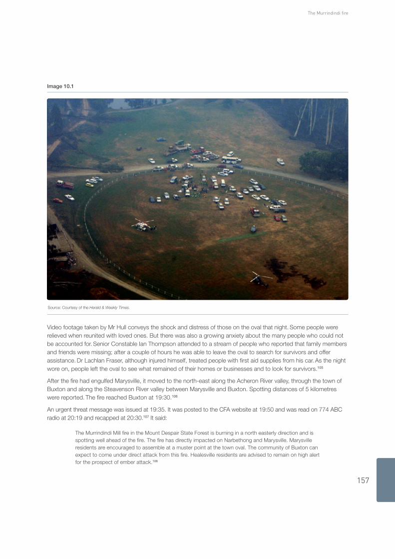
After the firestorm swept through Marysville people again gathered at Gallipoli Park. Among them were CFA and DSE firefighters who had retreated from Kings Road after the wind change, residents and personnel who had sheltered in the CFA shed and at the DSE office, and residents who had survived the fire in their homes. Mrs Harrow counted 65 people other than firefighters at the oval.104
157
The Murrindindi fire
image 10.1
Source: Courtesy of the Herald & Weekly Times.
Video footage taken by Mr Hull conveys the shock and distress of those on the oval that night. Some people were relieved when reunited with loved ones. But there was also a growing anxiety about the many people who could not be accounted for. Senior Constable Ian Thompson attended to a stream of people who reported that family members and friends were missing; after a couple of hours he was able to leave the oval to search for survivors and offer assistance. Dr Lachlan Fraser, although injured himself, treated people with first aid supplies from his car. As the night wore on, people left the oval to see what remained of their homes or businesses and to look for survivors.105
After the fire had engulfed Marysville, it moved to the north-east along the Acheron River valley, through the town of Buxton and along the Steavenson River valley between Marysville and Buxton. Spotting distances of 5 kilometres were reported. The fire reached Buxton at 19:30.106
An urgent threat message was issued at 19:35. It was posted to the CFA website at 19:50 and was read on 774 ABC radio at 20:19 and recapped at 20:30.107 It said:
The Murrindindi Mill fire in the Mount Despair State Forest is burning in a north easterly direction and is spotting well ahead of the fire. The fire has directly impacted on Narbethong and Marysville. Marysville residents are encouraged to assemble at a muster point at the town oval. The community of Buxton can expect to come under direct attack from this fire. Healesville residents are advised to remain on high alert for the prospect of ember attack.108
Volume I: The Fires and the Fire-Related Deaths
158
Although by 19:25 there was an awareness that new alerts were needed for Taggerty, Acheron, Molesworth, Thornton, Rubicon, Snobs Creek, Eildon, Alexandra and nearby communities between Murrindindi and Yea, these were not included in the message issued at 19:35. Warnings to these communities were not issued until 22:00. At 20:31, however, UGFM broadcast another interview with Mr Lovick, in which he said the fire was spotting a considerable distance and was across the Maroondah Highway 2 or 3 kilometres south of Taggerty. He also expressed his anxiety about Rubicon and Thornton overnight and the next day.109
Because of concern for firefighters’ safety, all Murrindindi tankers and the Flowerdale tanker were recalled to Yea at about 20:00.110
By 20:20 the Alexandra crew had fallen back from Buxton to Taggerty and was planning to protect the edge of the town from the approaching fire. By 20:35, however, most crew members had fallen back to Alexandra; only a few remained for life and property protection.111
Early in the morning of 8 February, the Kilmore East and Murrindindi fires merged.112
Warnings
The next urgent threat message, distributed at 20:22, contained warnings for residents of Murrindindi and Limestone, to the north and north-east of the fire’s point of origin. This message was posted on the CFA website at 20:33 and was read on 774 ABC at 20:48 and 21:00. It was re-issued at 20:45, posted on the CFA website at 21:00, and read on 774 ABC at 21:19. The message provided inaccurate information about the direction of the fire; this was remedied in a message prepared at 20:30. The amended message was, however, not distributed by the Benalla Integrated Fire Agency Coordination Centre, and so was not posted to the CFA website or read on 774 ABC.113
At 21:04 UGFM broadcast an interview with Mr Rice of the CFA’s Alexandra Group. After saying the fire had reached Narbethong, Marysville and Buxton, Mr Rice said, ‘The edge of the fire as I take it is sort of half way between Buxton and Taggerty at this stage. We are making a stand on the fire on the southern side of Taggerty township down around south Cathedral Lane area’.114
From 20:57 onwards the Alexandra Incident Control Centre distributed alerts and threat messages. It issued an alert message for residents of Alexandra at 21:49, advising them that a firebreak was being constructed around the town and that they should have their fire plans in place. This message was posted on the CFA website at 22:05.115
The strong south-westerly winds after the wind change funnelled fire along the valleys. Lightning strikes were recorded across the fire ground between 16:51 and 21:48: they were produced by the huge pyrocumulonimbus cloud that had developed above the fire. The lightning triggered yet other fires between the Murrindindi and Bunyip fires.116
By about 22:00 the fire was just south of Taggerty. Although the weather conditions had moderated, the fire had generated so much energy it took several hours for its momentum to slow. It was not until the early hours of 8 February that any change in fire behaviour was observable and suppression activities in the cleared and semi-cleared agricultural land around Taggerty could begin.117
At 22:02 an urgent threat message was issued for the communities of Taggerty, Acheron, Thornton, Rubicon, Snobs Creek, Eildon, Alexandra and Molesworth. The message was posted on the CFA website at 22:40 and was read on 774 ABC at 22:32, 22:52 and 23:05.118
The Alexandra Incident Control Centre issued a further urgent threat message at 23:35.119 The message repeated the contents of the previous one and provided the following further information:
An update on the Marysville township:
We understand that everyone is safe in Marysville and are assembled at Gallipoli Park. There are reports that a number of houses have been burnt, so stay tuned to ABC radio as further details come to hand.
159
The Murrindindi fire
This message was posted on the CFA website at 23:45 and was read on 774 ABC at 23:42. Updated messages to similar effect, including the statement that everyone in Marysville was safe, were distributed at regular intervals during the early morning of 8 February and were posted on the CFA website. The statement that everyone was safe in Marysville appeared in incident situation reports prepared by the Office of the Emergency Services Commissioner during Sunday 8 February.120
Obviously, not everyone in Marysville was safe at the time the Alexandra ICC distributed these messages. Mr Lovick explained the basis for the statement in his evidence:
At this stage of the evening [22:54], and until much later in the morning [of 8 February], we understood that most of the residents at Marysville were safe and gathered at the oval. Although I was troubled by Greg Williamson’s comments [that people were going into houses, the houses were burning, and no one was coming out] and considered that possibly there may be some fatalities, there was no confirmation. The fact that there was a large crowd of residents at Gallipoli Park indicated to me that any fatalities would be few. It wasn’t until after shift changeover when people started coming off the line (between 0800 and 0900 hours on 8 February) that we had more information to indicate fatalities from the Murrindindi fire. Even then information about fatalities was still vague and not first hand.121
The wide distribution of the inaccurate statement that everyone in Marysville was safe is at best highly regrettable—the community deserved better than this.
relief centres
A number of emergency relief centres were opened on 7 February. One of them, at Yea, was used largely by people who had evacuated because of the Kilmore East fire. Another, at Alexandra Secondary College, hosted many people who had evacuated from Marysville and Buxton.122
Marysville resident Mrs Mary Kenealy described her experience at the Alexandra emergency relief centre:
The volunteers who worked there were extremely kind and they did their best in the extreme conditions of the day. The conditions those poor people were working in gave them no chance and the whole place seemed badly under-prepared.
The first thing we did at the relief centre was sign in on Red Cross forms. We sat down for a little while and the centre gradually started to fill up with people. As I sat in the relief centre, things around me seemed to be in total chaos. It appeared that no-one was organised. The centre started filling with smoke and it became very hot inside because there was no power and therefore no air conditioning.123
These observations lend weight to recommendation 6.4 in the Commission’s Interim Report—that councils review their municipal emergency management plans to ensure that there is adequate provision for relocation during bushfires.124
At 23:00 a third emergency relief centre was opened, this time at the memorial hall in Healesville, in the neighbouring Shire of Yarra Ranges. This centre was open 24 hours a day until 11 February and then between 08:00 and 20:00 until 23 February, when it opened again for 24 hours because of the risk of fire. The centre closed permanently on 24 February.125
aFTer 7 February10.1.3
In the early hours of 8 February DSE crews led by Mr Williamson began the difficult and dangerous task of clearing the road from Marysville to Buxton and Taggerty of fallen and sometimes still burning trees. They reached Taggerty at 02:30 and then turned around and cleared the road again in order that ambulances could reach Marysville.
The people who remained on the oval in Marysville were able to drive out to Alexandra along this road at about noon.126
In the days following 7 and 8 February the Murrindindi Municipal Emergency Coordination Centre continued to oversee and assist in the relief and recovery efforts. From 7 to 13 February the MECC was fully staffed and operated 24 hours a day. It remained open until 7 March.127

Volume I: The Fires and the Fire-Related Deaths
160
In the week following the fires the Alexandra emergency relief centre was relocated to the Alexandra Leisure Centre. It remained open for a number of weeks.128
Although the fire in cleared agricultural land was contained, the fire burning in heavily forested public land continued for weeks and was not formally declared contained until 5 March. By this time the Kilmore East and Murrindindi fires, which had merged, had burnt 168,542 hectares.129
The Murrindindi fire resulted in the death of 40 people. (The circumstances of their deaths are discussed in Chapter 18.) More than 500 houses were destroyed or damaged, mainly in and around Marysville, Narbethong and Buxton. The commercial centre of Marysville was destroyed, as was the core of the town’s economic activity in tourism and hospitality. Much of the town’s public infrastructure—including the police station, primary school, kindergarten and health clinic—was also destroyed.130
10.2 Fuel ManageMenT
Although some fuel-reduction burns had been conducted in the areas burnt by the Murrindindi fire, they were not of consequence. Burns carried out in preceding years on the edge of the forested areas around Marysville and the town’s ‘strategic firebreak’ had little, if any, effect on the fire’s momentum as it swept towards and then through Marysville on 7 February.131 Fuel management is discussed in detail in Chapter 7 of Volume II.
10.3 incidenT ManageMenT
On 7 February 2009 only three members of the incident management team held level 3 qualifications—the planning officer, the logistics officer and the situation officer. The situation officer did not assume his position until about two hours after the fire had begun. No safety adviser was appointed to the Alexandra Incident Control Centre on the day.132
The incident management team did not prepare an incident action plan until the early hours of 8 February, when the IMT meeting focused on ‘getting an Incident Action Plan out’. This reveals a weakness in planning. The AIIMS manual recognises that it can be ‘extremely difficult’ to develop a written plan in the initial stages of a rapidly escalating incident but specifies that in such cases ‘an assessment of the situation should still occur and an objective be determined’. An IMT meeting at 17:30 on 7 February concluded that the ‘objectives’ were ‘firstly firefighter safety and then to protect people and assets, particularly around Marysville, Narbethong and Buxton’. There is no evidence, however, that these objectives were communicated to the fire ground, and nor was a strategy developed to achieve them.133
In 2002, in the inquest into the deaths resulting from the Linton fire, the coroner noted that one of the roles of an incident action plan is to put senior members of the incident management team in a position ‘to consider, analyse and evaluate all relevant material so that the appropriate direction … can be given to those on the fire ground not possessed of all requisite information needed to make appropriate decisions, in terms of safety and operational effectiveness’.134
The incident management team issued no red flag warning about the wind change, although it did issue a ‘weather warning’. There is no evidence that the weather warning was acknowledged up and down the chain of command, as is required for a red flag warning under DSE guidelines.135 The poor understanding of the potential impact of the wind change contributed to the dangers faced by firefighters when they tried to light a back-burn at Kings Road in Marysville.
Incident management is discussed in detail in Chapter 2 of Volume II.

161
The Murrindindi fire
10.4 eMergency ManageMenT
box 10.3 Case study: the Municipal emergency Management Plan
The Commission did not consider in detail the emergency management arrangements of all municipalities affected by the January and February 2009 fires, although it did make some inquiries into the arrangements of the Shire of Murrindindi. The following case study details how these arrangements affected the response to the fires.
The main impact of the Murrindindi fire was felt in the Shire of Murrindindi, which encompasses the townships of Narbethong, Granton, Marysville, Buxton and Taggerty. The fire burned into the Shire of Yarra Ranges but did not affect any population centres in that municipality. Murrindindi Shire also contains the townships of Kinglake, Kinglake West, Pheasant Creek, Hazeldene, Flowerdale and Glenburn, which were severely affected by the Kilmore East fire.136 Together, these fires tested Murrindindi’s municipal emergency management arrangements.
The Murrindindi Municipal Emergency Management Plan, or MEMP, was first adopted in 1996 and has been regularly updated since. As required by Victoria’s Emergency Management Act 1986, the Murrindindi MEMP is audited once every three years by the Director of Victoria State Emergency Service. It was last audited in October 2007, when it was assessed as complying with the guidelines issued by the Coordinator in Chief under the Act. The MEMP sets out the general framework for prevention of, the response to and recovery from emergencies affecting the shire.137
Despite the Murrindindi MEMP being assessed as complying with the guidelines of the Emergency Management Act, the Commission considers the emergency management planning that existed for Murrindindi Shire lacked the substance, detail and precision needed to respond adequately to the events of 7 February. The following points are of particular note:
The MEMP did not include planning for preventing or responding to bushfire. The shire has a fire prevention ■■
plan, but the plan’s development and review are divorced from the municipal emergency management planning process.
The MEMP did not include a plan for the evacuation of Marysville or any other township in the municipality ■■
or locations identified to be at risk of bushfire. There was no detail covering matters such as the following:
the roads on which evacuation might take place –
the size and nature of the population –
any vulnerable members of the community who might need assistance to evacuate –
any sites used by vulnerable groups such as schools and hospitals –
any places of refuge and possible emergency relief centres. –
Local emergency management planning also failed to identify who would take what action to effect an evacuation and the triggers for that action. The MEMP simply repeated the general delineation of responsibilities for evacuation set out in the State Emergency Response Plan.
Although municipal emergency management planning did not extend to the practicalities of evacuating Marysville, Marysville VICSES had given the subject some thought. In 2006 and 2007, in consultation with local police and with assistance from Murrindindi Shire Council, Marysville VICSES compiled a list of elderly people and others who might need assistance evacuating their homes in an emergency.138 As detailed earlier in this chapter, VICSES implemented its plan on 7 February.
Murrindindi Shire Council also kept a list of vulnerable residents—including the elderly, people with disabilities and people of a non–English speaking background—who might need special consideration. This list was not used on 7 February.139
The dissemination of public information and warnings about the Murrindindi fire did not occur in the manner described in the Murrindindi MEMP; nor was information released in conjunction with the municipal emergency response coordinator. And the procedure for releasing emergency information to radio UGFM, set out in the Murrindindi MEMP, was not followed.140
Volume I: The Fires and the Fire-Related Deaths
162
WaTer SuPPly10.4.1
The urban water supply system for Marysville and Buxton had limited capacity to supply water for firefighting purposes. The system had been designed for normal domestic and commercial use, with some, but not unlimited, capacity for firefighting.
Marysville’s water supply comes from the Steavenson River, from which it is diverted by a turbine about 200 metres below Steavenson Falls on the eastern edge of the town. The water is diverted from the river to Aub Cuzens Reservoir, on the south-western edge of Marysville, which has a capacity of 100 megalitres. Under normal conditions the reservoir can hold enough water to supply the towns of Marysville and Buxton for four to six months.141
From the reservoir water flows into the Marysville reticulation network and on to Buxton. The water supply is driven by gravity, and water pressure to most properties in Marysville and Buxton is usually ‘good’.142
In response to the extreme fire weather warnings issued on 5 February for 7 February, Goulburn Valley Water district managers were instructed to ensure that water storages were as full as possible. Aub Cuzens Reservoir was full on 6 February.143
On 9 February the reservoir was holding 80 megalitres. Some 20 megalitres of water had flowed out of the reservoir during the three-day period—the equivalent of a month’s water for Marysville and Buxton.144
When the power failed at 17:15 on 7 February the control valve on the Buxton pipeline automatically closed, and from about 17:30 no water flowed into the Buxton tank. The tank was probably empty by 21:30, leaving Buxton residents without water.145
In addition, water could not flow quickly enough through the pipes in the Marysville reticulation network to meet the high demand for water as the fire approached the town. Water pressure dropped throughout the network, and there was no water flow in parts of the town at higher elevations. More than half of Marysville was without water on the evening of 7 February.146
Fire damaged some parts of Marysville’s reticulation network, although this had no impact on the town’s water supply because the reservoir was full. Only one water main failed. None of the damage would, however, explain the loss of water pressure in Marysville on 7 February. The loss resulted from extreme demands placed on a system that had been designed for normal domestic and commercial use, with only limited capacity to supply water for fighting fires.147
Water was restored to dwellings in Marysville by the evening of Monday 9 February; Buxton’s water supply was restored by the evening of 10 February. Residents were advised to boil water for drinking in Buxton until 18 February and in Marysville until 24 March. Repairs to the supply main to Aub Cuzens Reservoir started in March and were completed on 10 April.148
rOaDblOCKS10.4.2
Throughout the afternoon of 7 February roadblocks were established in order to restrict the movement of traffic into areas of fire activity.149
On 8 February numerous full road closures from Buxton to Marysville were activated at the request of the incident management team. This was done to prevent access to Marysville and to areas where fires were still burning, among them Taggerty, Thornton, Kathkin, Narbethong and Yea.150
Road closures, full and partial, were introduced so as to prevent access to areas that were unsafe or that needed to be restricted pending further investigation. Senior Sergeant Gary Barton explained that the intention was to preserve crime scenes, to protect property and to protect people from the continuing fires, and that a further reason for the closures was the state of the roads.151
Even after the fires were controlled and the roads were safe, access to Marysville was restricted. Under Victoria’s Coroners Act 1985 the coroner issued directions to Victoria Police that access to Marysville was to be restricted while the search for remains was conducted. These directions remained in force until about 21 March.152

163
The Murrindindi fire
After the coroner’s directions had been lifted Superintendent Peter Billing considered, taking account of advice from the Department of Human Services and Murrindindi Shire, that it was inappropriate to allow unrestricted access to Marysville. Access was restricted at this time on the basis of the common law obligation of police to protect life and property, including by denying people access to areas reasonably believed to be unsafe. Police limited access to those residents who had obtained safety information about the remaining risks in the town. A system of stickers for vehicles and wristbands for residents was introduced, so that residents could move more freely through the roadblocks. The restrictions remained in operation until 30 March, when the roads to Marysville were re-opened.153
COMMuniCaTiOnS10.4.3
One of the problems identified in a police debrief after the fires was police radio communications—in particular, the incompatibility between radios used by metropolitan and regional police. The metropolitan radio network is digital but the regional system is analogue.154 This issue is discussed in Chapter 3 in Volume II.
10.5 cOncluSiOnS
The failure to direct and subsequently check staff allocations to incident control centres before 7 February contributed to the deficiencies in the incident management team with responsibility for the Murrindindi fire. The Commission acknowledges that Mr Peter Farrell, the DSE Land and Fire Manager for the North-East Area, was already overseeing the Nariel ski hut fire before 7 February, but the approach he adopted, along with that of Mr Peter Creak, Operations Manager of CFA Region 12, of deploying staff to ICCs as required, was flawed and indicative of poor judgment in the lead-up to 7 February.
In the Commission’s view, a Level 1 Incident Controller was an unsuitable choice for the position of Incident Controller for the Murrindindi fire, the incident management team was inadequately prepared, and it took too long to appoint a level 3 Incident Controller. This is not a criticism of those individuals who were underqualified for the positions they held in the IMT. The Commission does, however, criticise the lack of coordination between the CFA and DSE in planning for the day, their decision to work from separate facilities in Alexandra, and in particular the staff who oversaw these arrangements. These limitations led to shortcomings in the Alexandra IMT’s management of the fire.
In its interim report the Commission recommended that the CFA and DSE develop procedures to ensure that Incident Controllers are appointed on the basis of their competency, regardless of the land tenure at the point of a fire’s ignition. Murrindindi is an example: a DSE level 1 and then level 2 Incident Controller managed the fire during 7 February while in the same town a CFA level 3 Incident Controller operated separately from a group centre. The Commission was advised that the CFA and DSE have acted on this recommendation.155
The Commission considers that the broad objectives of firefighter safety and protection of life and property adopted by the Alexandra Incident Management Team in lieu of an incident action plan did not provide the necessary strategic and operational direction for managing a fast-moving, complex fire with large numbers of resources. Although incident action plans might not have been completed for other fires on 7 February, the absence of such a plan or clear objectives in the Alexandra IMT on the afternoon of 7 February is indicative of the lack of experience of the level 1 and level 2 Incident Controllers, and it contributed to inadequate organisation and limited the efficiency of those working on the Murrindindi fire.
The Alexandra IMT was further hindered by a lack of information on which to base planning and strategic decisions. It did not receive or make proper use of the full range of available information on fire behaviour. Had it received and analysed this information promptly, there would have been no doubt that Narbethong was under direct attack and that Marysville and Buxton ‘would be directly in the path of the new fire front’ after the wind change.156
The IMT did not seek local weather forecasts from the Bureau of Meteorology until well after the wind change had passed through Marysville; nor did it take account of the progression of the wind change across Victoria. The Commission considers this wind change information should have come from the integrated Emergency Coordination Centre, and the IMT’s failure to ask for a local weather forecast during the afternoon of 7 February avoidably deprived it of important information. The earlier than expected arrival of the south-westerly change and the lack of warning

Volume I: The Fires and the Fire-Related Deaths
164
for people in Marysville endangered the safety of firefighters and residents.157 The lack of a red flag warning, as well as limited fire weather information, meant that timely and accurate wind change information was not conveyed to all firefighters, including those about to embark on a dangerous back-burning operation in Marysville.
The failure to appoint a safety adviser probably contributed to the IMT attaching insufficient priority to communicating wind change information to firefighters and deprived the Incident Controller of an important source of advice about the occupational health and safety implications of tactical fire suppression decisions. Firefighter safety is discussed in greater detail in Chapter 3 of Volume II.
Lighting the back-burn at Marysville was a dangerous tactic and offered little likelihood of protecting the town. The firefighters concerned were well-intentioned but did not have the information they needed to make informed and reasoned judgments, and personnel in the IMT, who had more information, were not involved in making the decision. As it turned out, the back-burn made no difference to the effect of the fires when they arrived, but it did place the firefighters in an extremely dangerous situation. It is fortunate no-one was seriously injured or killed. Nevertheless, the firefighters displayed considerable courage in performing their task and should be commended for this.
The lack of a pre-positioned information officer and the relaying of warnings via the Benalla Integrated Fire Agency Coordination Centre, even after an information officer had been appointed, delayed the issuing of public warnings about the Murrindindi fire.
The warnings that were in fact issued by the Alexandra IMT on 7 February did not keep pace with the fast-changing situation. The first warning to Narbethong was issued when the fire was already there. The first warning to Taggerty was issued as the fire was on the southern edge of the town. The Commission does not criticise the individuals concerned, each of whom performed soundly in difficult circumstances. It does, however, stress the importance of pre-positioned IMTs on days of extreme fire danger and considers that greater emphasis should be given to collecting and analysing information and disseminating it to communities and firefighters on the ground.
The maintenance of roadblocks in the days and weeks after the fire was a source of continuing difficulty and frustration for residents of Marysville, Narbethong, Buxton and Taggerty who had remained in their homes and for those who had left but wanted to return. Introduction of the system of stickers to allow residents to move more freely through roadblocks was a sensible response to a complex situation: it allowed people access to Marysville while at the same time managing the safety and privacy of residents and the needs of the coronial inquiries. Issues around roadblocks are discussed in greater detail in Chapter 2 of Volume II.
Any emergency incident that necessitates the participation of police from both metropolitan and regional forces will face challenges with communications. The incompatibility between metropolitan and regional police radios is inefficient and could, in some situations, compromise safety. This matter is discussed in Chapter 3 of Volume II.
1 Exhibit 348 – Statement of Rice (WIT.3004.016.0091) [70]–[71]; Rice T8522:8–T8522:23; Exhibit 350 – Statement of Beer (WIT.3004.016.0016) [79]; Exhibit 345 – Statement of Steer (WIT.3024.003.0026) [26], [29]; Exhibit 370 – Statement of Weeks (WIT.105.001.0001_R) [19]; Exhibit 349 – Statement of Kennedy (WIT.102.001.0001_R) [9], [11]; Exhibit 6 – Revised Statement of Waller (WIT.002.002.0001) [338];
2 Exhibit 787 – Further Statement of Fogarty, Annexure 1 (WIT.3024.005.0260) at 0261; Exhibit 361 – Statement of Anderson (WIT.3032.001.0001) [33]; Exhibit 6 – Revised Statement of Waller (WIT.002.002.0001) [341]
3 Exhibit 22 – Statement of Williams, Annexure 1 (WIT.013.001.0012) at 0094
4 Exhibit 22 – Statement of Williams, Annexure 1 (WIT.013.001.0012) at 0094
5 Exhibit 557 – Meteorological Aspects of the Murrindindi Fire (BOM.901.0172) at 0189
6 Exhibit 557 – Meteorological Aspects of the Murrindindi Fire (BOM.901.0172) at 0189
7 Exhibit 557 – Meteorological Aspects of the Murrindindi Fire (BOM.901.0172) at 0189
8 Exhibit 22 – Statement of Williams, Annexure 1 (WIT.013.001.0012) at 0094
9 Exhibit 214 – Statement of Hollowood (WIT.3010.001.0338) [65]
10 Exhibit 215 – Supplementary Statement of Hollowood (WIT.3010.003.0287_R) [20]
11 Exhibit 215 – Supplementary Statement of Hollowood (WIT.3010.003.0287_R) [20]
12 Exhibit 980 – Correspondence – Houses Destroyed – Breakdown by Fire (CORR.1003.0048_R) at 0048_R
13 Exhibit 787 – Further Statement of Fogarty, Annexure 1 (WIT.3024.005.0260) at 0261
165
The Murrindindi fire
14 Exhibit 939 – Details Regarding Emergency Response (CFA.600.005.0195) at 0195, 0198; Exhibit 939 – Day by Day Breakdown – Murrindindi (DSE.HDD.0048.0545_13); Exhibit 939 – Aircraft Data 0809 (DSE.HDD.0048.0544_20) at 0544_26
15 Exhibit 994 – Murrindindi Fire – Fire Spread Map (DSE.HDD.0165.0053)
16 Farrell T8502:19–T8502:21, T8502:27–T8503:1, T8503:5–T8503:13, T8503:18–T8504:03
17 Exhibit 339 – Statement of Miller (WIT.3024.003.0093) [25]; Exhibit 506 – Statement of Creak (WIT.3004.008.0309) [16], Annexure 2 (WIT.3004.008.0338), Annexure 4 (WIT.3004.008.0347); Creak T8279:6–T8279:8, T8279:28–T8279:31, T8280:4–T8280:11, T8280:23–T8280:26, T8281:13–T8281:16, T8283:3–T8283:5; Rice T8515:18–T8515:21; Miller T8320:13–T8320:19
18 Exhibit 347 – Statement of Farrell (WIT.3024.003.0154) [23]; Farrell T8499:25–T8499:28
19 Exhibit 506 – Statement of Creak, Annexure 4 (WIT.3004.008.0347) at 0347; Exhibit 254 – Statement of Farrell, Annexure 3 (DSE.HDD.0012.2636_R) at 2746_R; Farrell T8500:5–T8500:25
20 Farrell T8503:5–T8503:11, T8503:18–T8504:09; Creak T8287:16–T8287:25, T8290:3–T8290:12
21 Exhibit 377 – Statement of Ellett (WIT.4006.001.0001) [55]–[56]
22 Exhibit 673 – DSE–CFA Local Mutual Aid Plan – North East Area 2008–09 (CFA.001.033.0023) at 0028
23 Exhibit 347 – Statement of Farrell (WIT.3024.003.0154) [11]
24 Farrell T8503:28–T8504:9
25 Exhibit 347 – Statement of Farrell (WIT.3024.003.0154) [11]
26 Hind T8208:21–T8208:25
27 Exhibit 375 – Statement of Caddell (WIT.3024.003.0050) [11]–[12]
28 Edgar T16751:3–T16751:4
29 Exhibit 347 – Statement of Farrell (WIT.3024.003.0154) [7]–[8]; Exhibit 339 – Statement of Miller (WIT.3024.003.0093) [30]; Exhibit 55 – Statement of Hunter (WIT.3004.001.0129) [4]; Exhibit 6 – Statement of Waller (WIT.002.002.0001) [333]
30 Exhibit 339 – Statement of Miller (WIT.3024.003.0093) [19]; Miller T8318:10–T8318:28
31 Exhibit 331 – Statement of Hind (TEN.101.001.0001_R) at 0001_R, Statement of Hind (SUMM.044.002.0579_R) at 0579_R–0581_R; Hind T8208:21–T8210:5; Exhibit 332 – Statement of Searle (SUMM.044.002.3033_R), Attachment (DSE.HDD.0021.0899_R), (DSE.HDD.0021.0900_R); Exhibit 333 – Statement of Joyce (SUMM.044.003.1952_R) at 1953_R–1954_R
32 Exhibit 214 – Statement of Hollowood (WIT.3010.001.0338) [65]
33 Lawlor T8197:6–T8197:21
34 Exhibit 130 – Supplementary Statement of Waller (WIT.3024.001.0073) [44]; Exhibit 6 – Revised Statement of Waller (WIT.002.002.0001) [334]; Exhibit 350 – Statement of Beer (WIT.3004.016.0016) [49]
35 Exhibit 350 – Statement of Beer (WIT.3004.016.0016) [63]; Beer T8567:26–T8567:28, T8569:5–T8569:14; Webb Ware T8227:2–T8227:8; Creak T8290:13–T8290:31
36 Exhibit 338 – Supplementary Statement of Creak (WIT.3004.017.0001) [36]; Miller T8324:23–T8325:12
37 Exhibit 6 – Revised Statement of Waller (WIT.002.002.0001) [334]; Exhibit 335 – Statement of Lauder (SUMM.044.002.2177_R) at 2178_R; Lauder T8247:31–T8248:9
38 Exhibit 335 – Statement of Lauder (SUMM.044.002.2177_R) at 2177_R–2180_R; Lauder T8249:6–T8249:17, T8250:12–T8250:31
39 Exhibit 339 – Statement of Miller (WIT.3024.003.0093) [53]; Miller T8319:19–T8320:12
40 Exhibit 374 – Statement of Skelton (WIT.3024.003.0207) [23], [38], Annexure 6 (DSE.HDD.0017.0415); Exhibit 7 – Transcript – 774 ABC Radio (SUMM.001.002.0001) at 0299; Exhibit 370 – Statement of Weeks (WIT.105.001.0001_R) [17]–[18], [21]
41 Exhibit 93 – Statement of Willans (WIT.051.001.0001) [17], [23]–[27]; Willans T3028:8–T3028:15, T3037:2–T3037:25; Bowdern T8434:16–T8434:20
42 Willans T3033:7–T3033:18
43 Exhibit 360 – Statement of Cobb (WIT.3024.004.0032) [35]–[46]; Willans T3031:22–T3032:6; Bowdern T8437:15–T8437:24
44 Exhibit 6 – Statement of Waller (WIT.002.002.0001) [335]; Lawlor T8197:12–T8197:21; Webb Ware T8227:28–T8228:2
45 Exhibit 339 – Statement of Miller (WIT.3024.003.0093) [46], [57]; Exhibit 6 – Revised Statement of Waller (WIT.002.002.0001) [335]–[336]
46 Exhibit 347 – Statement of Farrell (WIT.3024.003.0154) [28]; Exhibit 339 – Statement of Miller (WIT.3024.003.0093) [59]; Beer T8572:10–T8572:23; Miller T8327:25–T8327:26; Rice T8524:22–T8525:17
47 Exhibit 547 – Statement of Haynes (WIT.3004.023.0011) [148]–[152]; Exhibit 339 – Statement of Miller (WIT.3024.003.0093) [17]; Exhibit 348 – Statement of Rice (WIT.3004.016.0091) [14]; Creak T10897:19–T10897:30, T9033:1–T9033:26; Miller T8314:19–T8314:24, T8315:18–T8315:23
48 Exhibit 557 – Meteorological Aspects of the Murrindindi Fire (BOM.901.0172) at 0180; Lawlor T8198:2–T8198:22
49 Lawlor T8194:18–T8195:6; Lauder T8242:28–T8243:8
50 Exhibit 372 – Statement of Rowles (WIT.3010.005.0313) [18]–[19], Attachment 3 (WIT.3010.005.0358_02) at 0358_02; Exhibit 377 – Statement of Ellett (WIT.4006.001.0001) [63]
51 Exhibit 372 – Statement of Rowles, Attachment 3 (WIT.3010.005.0358_02) at 0358_02
52 Exhibit 372 – Statement of Rowles (WIT.3010.005.0313) [20], Attachment 1 (WIT.3010.005.0325), Attachment 3 (WIT.3010.005.0358_02); Exhibit 377 – Statement of Ellett (WIT.4006.001.0001) [80]–[81], Attachment 8 (WIT.4006.001.0356), Attachment 9 (WIT.4006.001.0446), Attachment 10 (WIT.4006.001.0699)
Volume I: The Fires and the Fire-Related Deaths
166
53 Exhibit 372 – Statement of Rowles (WIT.3010.005.0313) [19]
54 Lawlor T8198:14–T8198:16, T8198:26–T8199:1
55 Exhibit 370 – Statement of Weeks (WIT.105.001.0001_R) [19]
56 Exhibit 329 – STAR Tool – Murrindindi Fire (EXH.329.0001); Exhibit 6 – Revised Statement of Waller (WIT.002.002.0001) [338]; Lawlor T8198:24–T8198:26, T8198:29–T8200:15
57 Exhibit 6 – Revised Statement of Waller (WIT.002.002.0001) [339]
58 Exhibit 370 – Statement of Weeks (WIT.105.001.0001_R) [20]
59 Exhibit 7 – Transcript – 774 ABC Radio (SUMM.001.002.0001) at 0323, 0336–0337, 0344; Exhibit 374 – Statement of Skelton (WIT.3024.003.0207) [28], Annexure 7 (DSE.HDD.0002.8370); Exhibit 346 – Statement of Rattray-Wood (WIT.3024.003.0229) [29]
60 Exhibit 337 – Statement of Lawlor (WIT.3024.003.0190) [6], [17]–[18]; Lawlor T8258:1–T8758:14, T8264:15–T8264:23
61 Lawlor T8265:2–T8266:12
62 Exhibit 337 – Statement of Lawlor (WIT.3024.003.0190) [10]
63 Exhibit 337 – Statement of Lawlor (WIT.3024.003.0190) [16]
64 Exhibit 345 – Statement of Steer (WIT.3024.003.0026) [33]; Steer T8477:11–T8478:1
65 Miller T8319:19–T8320:3, T8380:9–T8380:19
66 Exhibit 370 – Statement of Weeks (WIT.105.001.0001_R) [22]
67 Exhibit 370 – Statement of Weeks (WIT.105.001.0001_R) [22]
68 Exhibit 353 – Statement of Jones (WIT.3004.016.0177) [44]; Exhibit 348 – Statement of Rice (WIT.3004.016.0091) [72]–[75]; Rice T8529:3–T8529:21
69 Exhibit 337 – Statement of Lawlor (WIT.3024.003.0190) [19], [21]–[24]
70 Exhibit 443 – Statement of Overland, Annexure 1 (WIT.3010.009.0244) at 0272
71 Exhibit 101 – Statement of Rhodes, Attachment (WIT.3004.003.0049) at 0049–0051, Attachment (WIT.3004.002.0864) at 0864–0868; Exhibit 3 – Statement of Rees, Annexure 6 (WIT.004.001.0238) at 0240–0241; Exhibit 359 – Statement of Fiske (WIT.3004.017.0261) [7]
72 Exhibit 367 – Statement of Hunter (WIT.3009.001.0001) [13], [16]; Hunter T8955:2–T8955:15
73 Exhibit 367 – Statement of Hunter (WIT.3009.001.0001) [16]–[22]; Kenealy T8126:14–T8127:2; Hunter T8956:21–T8956:24, T8957:11–T8958:7
74 Exhibit 340 – Statement of Lovick (WIT.3024.003.0001) [15]–[19]; Farrell T8506:18–T8507:1; Lovick T8378:1–T8378:3, T8371:23–T8371:30; Exhibit 215 – Supplementary Statement of Hollowood (WIT.3010.003.0287_R) [20]; Exhibit 347 – Statement of Farrell (WIT.3024.003.0154) [57], [75]
75 Exhibit 371 – Revised Statement of Williamson (WIT.3024.004.0138) [49], Annexure 2, (DSE.HDD.0048.0037); Exhibit 556 – Statement of Creighton (VPO.001.040.0177) at 0185; Exhibit 348 – Statement of Rice (WIT.3004.016.0091) [90]; Williamson T10495:15–T10495:21, T10496:31–T10497:6; Webb Ware T8234:9–T8234:17; Rice T8534:21–T8535:10; Beer T8574:20–T8575:24
76 Exhibit 346 – Statement of Rattray-Wood (WIT.3024.003.0229) [36], [38]; Exhibit 374 – Statement of Skelton (WIT.3024.003.0207) [33]–[34], Annexure 11 (DSE.HDD.0004.0028), Annexure 12 (DSE.HDD.0004.0029); Exhibit 3 – Statement of Rees, Annexure 31 (WIT.004.001.0509) at 0576, 0589; Exhibit 7 – Transcript – 774 ABC Radio (SUMM.001.002.0001) at 0371–0372, 0373–0375, 0396–0397
77 Miller T8344:26–T8355:8; Lovick T8388:20–T8389:16
78 Exhibit 371 – Revised Statement of Williamson (WIT.3024.004.0138) [57]; Exhibit 360 – Statement of Cobb (WIT.3024.004.0032) [25], [58]
79 Exhibit 353 – Statement of Jones (WIT.3004.016.0177) [64]; Exhibit 357 – Statement of Malcolm (WIT.3004.017.0251) [32]; Exhibit 360 – Statement of Cobb (WIT.3024.004.0032) [57]; Jones T8638:21–T8638:23, T8640:3–T8640:8, T8640:21–T8641:8; Williamson T10499:22–T10499:25
80 Exhibit 360 – Statement of Cobb (WIT.3024.004.0032) [60]
81 Cobb T8772:18–T8772:22; Williamson T10503:5–T10503:28
82 Miller T8351:4–T8351:25, T8532:9–T8532:30; Exhibit 343 – Statement of Bowdern (WIT.3024.003.0068) [61]; Bowdern T8445:22–T8445:26
83 Exhibit 370 – Statement of Weeks (WIT.105.001.0001_R) [24]
84 Exhibit 351 – Statement of Hamill (WIT.3010.006.0194) [10]; Exhibit 363 – Statement of Collyer (WIT.3010.006.0183_R) [25]; Exhibit 373 – Statement of Thompson (WIT.3010.009.0291) [9], [16]
85 Exhibit 181 – Statement of Wasley (WIT.073.001.0001_R) [46]; Exhibit 369 – Statement of Brown (WIT.108.001.0001_R) [19]–[23]; Exhibit 339 – Statement of Miller (WIT.3024.003.0093) [82]; Exhibit 351 – Statement of Hamill (WIT.3010.006.0194) [11]; Lovick T8387:27–T8387:28, T8388:24–T8388:28; Rice T8535:24–T8535:28; Collyer T8828:26–T8828:31; Brown T8996:15–T8997:2, T8998:7–T8998:16; Wasley T5721:19–T5721:25; Collery T8416:20–T8416:26; Miller T8343:23–T8344:1; Hamill T8598:6–T8598:23
86 Exhibit 351 – Statement of Hamill (WIT.3010.006.0194) [12]
87 Exhibit 39 – Statement of Hull (WIT.030.001.0001_R) [15]; Hamill T8599:14–T8599:23
88 Exhibit 64 – Statement of Dwight (WIT.037.001.0001_R) [40]; Exhibit 363 – Statement of Collyer (WIT.3010.006.0183_R) [27]–[30]; Dwight T2066:18–T2067:29; Collyer T8841:23–T8843:12
89 Exhibit 64 – Statement of Dwight (WIT.037.001.0001_R) [41]
90 Hamill T8598:15–T8598:25, T8600:24–T8601:4; Dwight T2066:16–T2066:21, T2067:7–T2067:21; Collyer T8842:25–T8843:12, T8848:28–T8849:12
91 Hamill T8600:24–T8601:11; Dwight T2068:18–T2069:9
92 Exhibit 367 – Statement of Hunter (WIT.3009.001.0001) [26]–[27]; Exhibit 368 – Statement of Bates (WIT.110.001.0001_R) [18]–[21]

167
The Murrindindi fire
93 Exhibit 363 – Statement of Collyer (WIT.3010.006.0183_R) [33]–[36]; Exhibit 351 – Statement of Hamill (WIT.3010.006.0194) [20]; Exhibit 367 – Statement of Hunter (WIT.3009.001.0001) [28]; Exhibit 368 – Statement of Bates (WIT.110.001.0001_R) [23]–[24]; Exhibit 29 – Statement of Ferguson (WIT.022.001.0001_R) [23]; Exhibit 336 – Statement of Rishworth (WIT.098.001.0001_R) [30]; Collyer T8849:25–T8852:15; Hamill T8602:3–T8603:3; Ferguson T935:31–T936:4
94 Exhibit 557 – Meteorological Aspects of the Murrindindi Fire (BOM.901.0172) at 0184; Exhibit 130 – Statement of Waller (WIT.3024.001.0073) [56]; Lawlor T8202:10–T8203:8
95 Exhibit 130 – Statement of Waller (WIT.3024.001.0073) [53]; Lawlor T8263:17–T8263:23
96 Exhibit 334 – Statement of Webb Ware (WIT.3004.016.0205) [47]–[48]
97 Exhibit 371 – Revised Statement of Williamson (WIT.3024.004.0138) [73]
98 Exhibit 371 – Revised Statement of Williamson (WIT.3024.004.0138) [73]
99 Exhibit 357 – Statement of Malcolm (WIT.3004.017.0251) [41]–[44]; Exhibit 353 – Investigation Report Yarck Tankers 1 and 2 (CFA.001.028.0001); Jones T8647:4–T8648:10; Williamson T10507:27–T10508:11; Cobb T8776:7–T8776:28; Rice T8535:5–T8535:10
100 Jones T8646:6–T8646:12
101 Exhibit 353 – Investigation Report Yarck Tankers 1 and 2 (CFA.001.028.0001) at 0007–0008; Exhibit 338 – Statement of Creak (WIT.3004.017.0001) [130]; Jones T8647:7–T8649:4
102 Lawlor T8202:10–T8202:12, T8204:12–T8204:14
103 Exhibit 359 – Statement of Fiske (VPO.001.030.0197_R) at 0201_R–0202_R; Exhibit 39 – Statement of Hull (WIT.030.001.0001_R) [16]–[17]
104 Exhibit 353 – Statement of Jones (WIT.3004.016.0177) [81]; Exhibit 360 – Statement of Cobb (WIT.3024.004.0032) [68]; Exhibit 357 – Statement of Malcolm (WIT.3004.017.0251) [44]–[46]; Exhibit 371 –Statement of Williamson (WIT.3024.004.0138) [82]; Exhibit 95 – Statement of Fraser (WIT.048.001.0001_R) [32]; Exhibit 39 – Statement of Hull (WIT.030.001.0001_R) [20]; Exhibit 362 – Statement of Glenn (WIT.066.001.0001_R) [27]–[29]; Exhibit 358 – Statement of Harrow (WIT.3004.016.0247) [14]; Fraser T3057:25–T3058:8; Glenn T8820:11–T8820:23; Harrow T8720:30–T8721:13; Thompson T10526:5–T10526:16
105 Exhibit 39 – Statement of Hull, Attachment 2 (WIT.030.001.0012); Exhibit 355 – Statement of Gleeson (WIT.3004.016.0152) [51]–[55]; Exhibit 373 – Statement of Thompson (WIT.3010.009.0291) [31]–[33]; Exhibit 95 – Statement of Fraser (WIT.048.001.0001_R) [34]–[35]; Malcolm T8708:9–T8708:18
106 Exhibit 13 – Statement of Newman (WIT.009.001.0001_R) [14]; Lawlor T8204:22–T8204:28
107 Exhibit 3 – Statement of Rees, Annexure 31 (WIT.004.001.0509) at 0606; Exhibit 7 – Transcript – 774 ABC Radio (SUMM.001.002.0001) at 0445–0446, 0452–0454
108 Exhibit 346 – Statement of Rattray-Wood (WIT.3024.003.0229) [42], Attachment 9 (DSE.HDD.0017.0409)
109 Exhibit 346 – Statement of Rattray-Wood (WIT.3024.003.0229) [41], [50]; Exhibit 370 – Statement of Weeks (WIT.105.001.0001_R) [27]
110 Exhibit 338 – Statement of Creak (WIT.3004.017.0001) [127]–[128], [130]
111 Exhibit 339 – Statement of Miller (WIT.3024.003.0093) [95]–[96]
112 Exhibit 340 – Statement of Lovick (WIT.3024.003.0001) [56]
113 Exhibit 346 – Statement of Rattray-Wood (WIT.3024.003.0229) [43]–[44], Attachment 10 (DSE.HDD.0016.0541), Attachment 11 (DSE.0156.1320.0350), Attachment 12 (DSE.0017.0115.0037); Exhibit 3 – Statement of Rees, Annexure 31 (WIT.004.001.0509) at 0617, 0623; Exhibit 7 – Transcript – 774 ABC Radio (SUMM.001.002.0001) at 0462–0463, 0468–0469, 0472, 0478–0479
114 Exhibit 370 – Statement of Weeks (WIT.105.001.0001_R) [28]
115 Exhibit 346 – Statement of Rattray-Wood (WIT.3024.003.0229) [47], [49], Attachment 13 (DSE.HDD.0058.0013), Attachment 15 (DSE.HDD.0058.0018); Exhibit 3 – Statement of Rees, Annexure 31 (WIT.004.001.0509) at 0634
116 Exhibit 557 – Meteorological Aspects of the Murrindindi Fire (BOM.901.0172) at 0184–0185; Exhibit 6 – Revised Statement of Waller (WIT.002.002.0001) [318]; Williams T740:23–T740:30, T743:13–T744:22
117 Lawlor T8204:30–T8205:13
118 Exhibit 346 – Statement of Rattray-Wood (WIT.3024.003.0229) [50], Attachment 16 (DSE.HDD.0058.0022); Exhibit 3 – Statement of Rees, Annexure 31 (WIT.004.001.0509) at 0643; Exhibit 7 – Transcript – 774 ABC Radio (SUMM.001.002.0001) at 0524, 0534, 0541
119 Exhibit 346 – Statement of Rattray-Wood (WIT.3024.003.0229) [56], Attachment 17 (DSE.HDD.0058.0025)
120 Exhibit 3 – Statement of Rees, Annexure 31 (WIT.004.001.0509) at 0653, 0669–0670, 0672, 0677, 0681, 0697, 0707–0708; Exhibit 7 – Transcript – 774 ABC Radio (SUMM.001.002.0001) at 0559–0560; Exhibit 346 – Statement of Rattray-Wood (WIT.3024.003.0229) [62], [65], [67]–[68], [71], [74], [76], Attachment 19 (DSE.HDD.0058.0030), Attachment 20 (DSE.HDD.0058.0035), Attachment 21 (DSE.HDD.0058.0040), Attachment 22 (DSE.HDD.0058.0042), Attachment 24 (DSE.HDD.0052.0363), Attachment 25 (DSE.HDD.0052.0365), Attachment 26 (DSE. HDD.0058.0048); Exhibit 5 – Statement of Esplin, Attachment 19 (WIT.005.001.1661) at 1758, 1767; Esplin T372:6–T372:13
121 Exhibit 340 – Statement of Lovick (WIT.3024.003.0001) [53]; Lovick T8406:23–T8407:15
122 Exhibit 377 – Statement of Ellett (WIT.4006.001.0001) [82]–[84]
123 Exhibit 323 – Statement of Kenealy (WIT.101.001.0001_R) [46]–[47]
124 B Teague, R McLeod, S Pascoe, 2009 Victorian Bushfire Royal Commission: Interim Report, Parliament of Victoria, Melbourne, August 2009 [6.71]–[6.73] and Recommendation 6.4
125 Exhibit 378 – Statement of Jack (WIT.4007.001.0001) [78]–[79]
126 Exhibit 371 – Revised Statement of Williamson (WIT.3024.004.0138) [91]–[96]; Exhibit 360 – Statement of Cobb (WIT.3024.004.0032) [81]; Exhibit 362 – Statement of Glenn (WIT.066.001.0001_R) [30]–[32]; Exhibit 369 – Statement of Brown (WIT.108.001.0001_R) [28]; Thompson T10527:30–T10528:3
Volume I: The Fires and the Fire-Related Deaths
168
127 Exhibit 377 – Statement of Ellett (WIT.4006.001.0001) [95]
128 Exhibit 323 – Statement of Kenealy (WIT.101.001.0001_R) [57]; Exhibit 377 – Statement of Ellett (WIT.4006.001.0001) [84], [98];
129 Exhibit 787 – Further Statement of Fogarty, Annexure 1 (WIT.3024.005.0260) at 0261; Lawlor T8205:14–T8205:20
130 Exhibit 214 – Statement of Hollowood (WIT.3010.001.0338) [65]; Exhibit 11 – Statement of Esplin, Attachment 1 (WIT.005.001.0049) at 0055, 0073–0076
131 Lawlor T8202:22–T8203:8
132 Exhibit 339 – Statement of Miller (WIT.3024.003.0093) [19]; Exhibit 345 – Statement of Steer (WIT.3024.003.0026) at [15], [33]
133 Exhibit 340 – Statement of Lovick (WIT.3024.003.0001) [25], [55], [57], [66]; Exhibit 475 – AIIMS Manual (TEN.121.001.0001) at 0089
134 Exhibit 546 – Linton Report (TEN.132.001.0001) at 0386
135 Exhibit 340 – Statement of Lovick (WIT.3024.003.0001) [39]; Lovick T8386:25–T8387:3; Exhibit 400 – Guideline 8.1.10: Communicating Essential Fire Ground Information (DSE.HDD.0012.1158) at 1159–1160; Rice T8535:11–T8535:18
136 Exhibit 484 – Map of the Murrindindi Shire Showing Fire Affected Areas (MAV.001.001.0037); Exhibit 11 – Statement of Esplin, Attachment 1 (WIT.005.001.0049) at 0061–0062, 0066, 0071, 0073–0076
137 Exhibit 377 – Statement of Ellett (WIT.4006.001.0001) [27], [33], Attachment 2 (WIT.4006.001.0021) at 0037, Attachment 4 (WIT.4006.001.0259) at 0260–0261
138 Exhibit 367 – Statement of Hunter (WIT.3009.001.0001) [13]; Hunter T8952:27–T8954:7
139 Exhibit 377 – Statement of Ellett, Attachment 2 (WIT.4006.001.0021) at 0050; Exhibit 377 – Correspondence – List of Disabled or Elderly Residents (CORR.0910.0081)
140 Exhibit 365 – Statement of Billing (WIT.3010.005.0018) [20]–[21]; Billing T8899:13–T8901:11; Exhibit 370 – Statement of Weeks (WIT.105.001.0001_R) [32]–[34]; Rice T8528:3–T8528:19, T8529:23–T8530:7; Weeks T9022:9–T9024:28
141 Exhibit 361 – Statement of Anderson (WIT.3032.001.0001) [13], Annexure 2 (WIT.3032.001.0021); Anderson T8785:17–T8786:19
142 Exhibit 361 – Statement of Anderson (WIT.3032.001.0001) [14]–[15], [18]–[20]; Anderson T8786:20–T8787:13, T8788:2–T8788:21
143 Exhibit 361 – Statement of Anderson (WIT.3032.001.0001) [25]–[26]; Anderson T8790:19–T8790:29
144 Exhibit 361 – Statement of Anderson (WIT.3032.001.0001) [29], [33(c)]; Anderson T8791:7–T8791:25
145 Exhibit 361 – Statement of Anderson (WIT.3032.001.0001) [30]–[33]; Anderson T8793:8–T8793:28
146 Exhibit 348 – Statement of Rice (WIT.3004.016.0091) [89]; Exhibit 556 – Statement of Creighton (VPO.001.040.0177) at 0183; Exhibit 379 – Statement of Jowett (WIT.109.001.0001_R) [48]; Exhibit 498 – Statement of Liesfield (WIT.7528.001.0001) at 0003; Exhibit 361 – Statement of Anderson (WIT.3032.001.0001) [33(a)], [58]–[63], Annexure 11 (WIT.3032.001.0048); Exhibit 555 – Statement of Ackerman (VPO.001.034.0294) at 0297; Rice T8533:15–T8534:15; Jones T8640:13–T8641:8; Anderson T8795:5–T8795:27, T8798:11–T8800:3
147 Exhibit 361 – Statement of Anderson (WIT.3032.001.0001) [38], Annexure 8 (WIT.3032.001.0034) at 0042; Anderson T8795:28–T8796:26
148 Exhibit 361 – Statement of Anderson (WIT.3032.001.0001) [33], [45]–[51]; Anderson T8800:4–T8801:12
149 Exhibit 372 – Statement of Rowles (WIT.3010.005.0313) [27]; Exhibit 351 – Statement of Hamill (WIT.3010.006.0194) [4]–[5]; Hamill T8594:8–T8594:29
150 Exhibit 364 – Statement of Barton (WIT.3010.005.0001) [26], [28]; Exhibit 364 – Police Day Book Notes for Alexandra Forward Commander Post (TEN.104.001.0001); Barton T8873:1–T8873:10
151 Exhibit 364 – Statement of Barton (WIT.3010.005.0001) [29]; Barton T8873:23–T8874:7, T8874:15–T8874:16
152 Exhibit 366 – Traffic Management Points During the Victorian Bushfires (VPO.300.002.0269) at 0276–0278; Walshe T11817:5–T11817:16; Billing T8918:29–T8919:19
153 Exhibit 366 – Traffic Management Points During the Victorian Bushfires (VPO.300.002.0269) at 0278–0280; Exhibit 385 – Statement of Cherry (WIT.107.001.0001_R) [37]; Exhibit 349 – Statement of Kennedy (WIT.102.001.0001_R) [21]–[22], [35]–[37]; Exhibit 13 – Statement of Newman (WIT.009.001.0001_R) [19]–[20]; Exhibit 77 – Statement of Walter (WIT.041.001.0001_R) [74]–[79]; Exhibit 366 – Statement of Rishworth (WIT.098.001.0001_R) [40]; Exhibit 377– Statement of Ellett (WIT.4006.001.0001) [93]; Cherry T9160:20–T9161:11; Kennedy T8551:28–T8552:7; Barton T8876:22–T8877:11; Newman T345:12–T346:9; Collery T8423:5–T8423:10, T8424:6–T8425:11; Glenn T8824:14–T8825:19; Billing T8919:8–T8921:21
154 Billing T8912:16–T8913:19
155 B Teague, R McLeod, S Pascoe, 2009 Victorian Bushfire Royal Commission: Interim Report, Parliament of Victoria, Melbourne, August 2009, Recommendation 9.2; Exhibit 547 – Statement of Haynes (WIT.3004.023.0011) [160]
156 Exhibit 340 – Statement of Lovick (WIT.3024.003.0001) [19]; Lovick T8370:7–T8370:8, T8377:12–T8377:14; Exhibit 337 – Statement of Lawlor (WIT.3024.003.0190) [16]; Steer T8477:29–T8477:31
157 Exhibit 340 – Statement of Lovick, Annexure 4 (DSE.HDD.0052.0275); Exhibit 343 – Statement of Bowdern (WIT.3024.003.0068) [61]; Exhibit 345 – Statement of Steer, Annexure 3 (DSE.HDD.0048.0016) at 0019; Exhibit 357 – Statement of Malcolm (WIT.3004.017.0251) [41]–[44]; Exhibit 353 – Investigation Report Yarck Tankers 1 and 2 (CFA.001.028.0001); Exhibit 557 – Meteorological Aspects of the Murrindindi Fire (BOM.901.0172) at 0184, 0210–0212; Steer T8482:26–T8482:30, T8486:2–T8490:29; Lovick T8375:24–T8375:31; Miller T8351:4–T8351:25, T8532:9–T8532:30; Bowdern T8445:22–T8445:26; Jones T8647:4–T8648:10; Williamson T10507:27–T10508:11; Cobb T8776:7–T8776:28; Rice T8535:5–T8535:10