the naming of russell county, township and village by
TRANSCRIPT

The Naming of Russell County, Township and Village
By Harry Baker
Prepared for the Russell and District Historical Society
Summary
The County of Russell is presumed to have been named between 1798 and 1800 after Peter Russell, who
because of the absence of the Lieutenant Governor John Graves Simcoe was appointed as Administrator of
Upper Canada which gave him authority to grant land across the province. The Township of Russell was
named Elmsley Township in 1797, but due to a clerical error by the Surveyor General of Canada was
inadvertently named Russell Township (possibly a mix-up between the name of the county and township). The
Village of Russell was first called Duncansville/Duncanville, after the first postmaster, William Duncan. In
1898 it was formally changed by the County Council to the Police Village of Russell. It is presumed that the
name was changed from Duncanville because locally it was known as Russell because the local Post Office’s
name was Russell and the Russell County land registry office was in Duncanville.
Peter Russell in the Colonial Government of Upper Canada
1792: Peter Russell receives the appointment of Receiver and Auditor General from Lt. Gov. John Graves
Simcoe and a seat on the Executive and Legislative councils of Upper Canada (present-day Ontario).
1796: Lt. Gov. Simcoe becomes ill and returns to England. Peter Russell becomes the Administrator of Upper
Canada which gives him authority to grant land across the province.
1799: When Peter Hunter appointed Lieutenant Governor of Upper Canada, Peter Russell resigns. Peter
Russell remains in York and dies in 1808.
Russell County
1774: After the Seven Years War (1756-63) between Britain and France ended, the Quebec Act (1774) of the
British Parliament established a permanent colonial administration in Canada. What was to become Upper
Canada, south of the Hudson Bay watershed was included in the Province of Quebec.
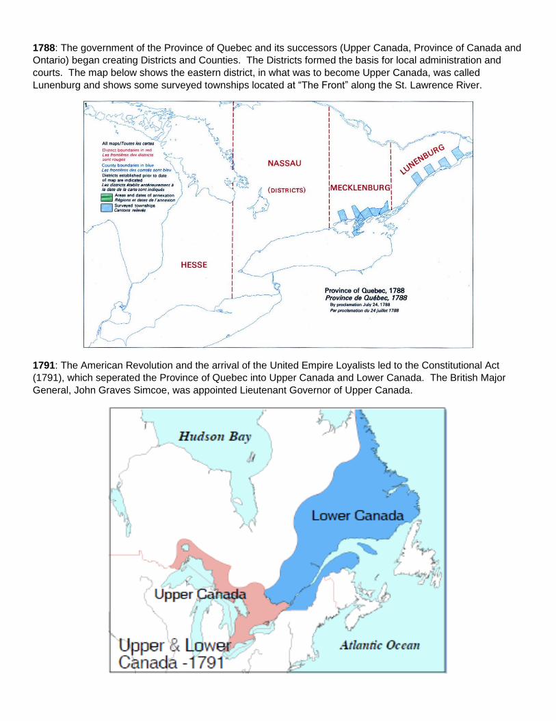
1788: The government of the Province of Quebec and its successors (Upper Canada, Province of Canada and
Ontario) began creating Districts and Counties. The Districts formed the basis for local administration and
courts. The map below shows the eastern district, in what was to become Upper Canada, was called
Lunenburg and shows some surveyed townships located at “The Front” along the St. Lawrence River.
1791: The American Revolution and the arrival of the United Empire Loyalists led to the Constitutional Act
(1791), which seperated the Province of Quebec into Upper Canada and Lower Canada. The British Major
General, John Graves Simcoe, was appointed Lieutenant Governor of Upper Canada.

1792: The first 19 counties were created for elections, developing militia and were the basis for surveying and
creation of townships for land registration. At that time, our area of Upper Canada was part of Stormont
County. (Archives of Ontario, Changing Shape of Ontario: early Districts and Counties)
1798: Russell County (named after Peter Russell) was created from the northern part of Stormont
County (Weaver E.P., 1913). Note: In one reference Russell County was created in 1800. (Archives of
Ontario Changing Shape of Ontario: early Districts and Counties)
1798: Russell County is shown on the map of Upper Canada in the Eastern District.
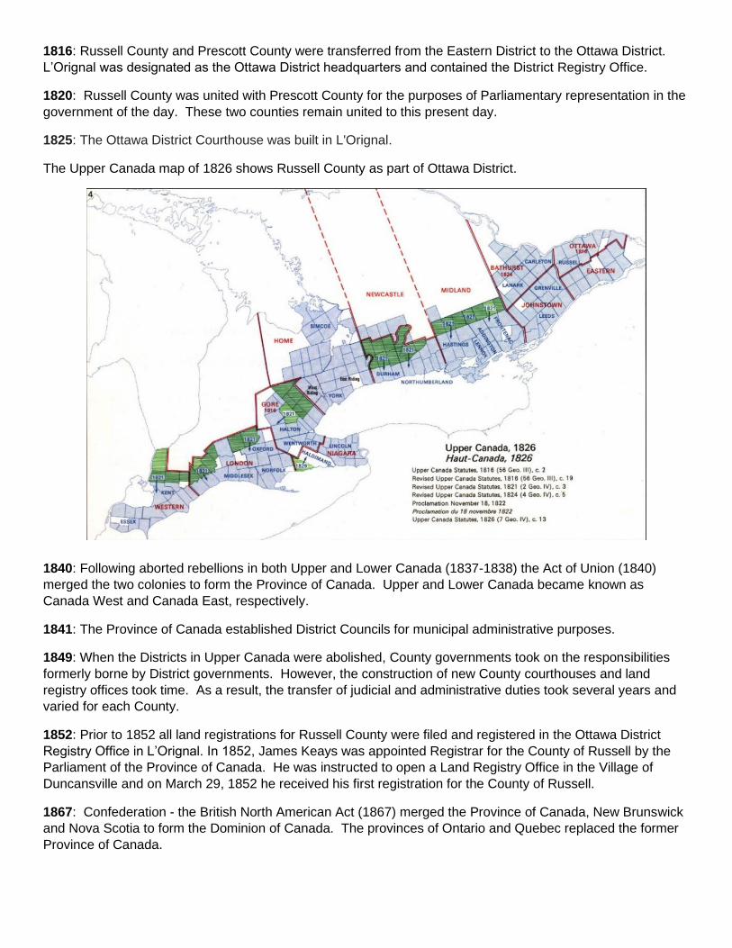
1816: Russell County and Prescott County were transferred from the Eastern District to the Ottawa District.
L’Orignal was designated as the Ottawa District headquarters and contained the District Registry Office.
1820: Russell County was united with Prescott County for the purposes of Parliamentary representation in the
government of the day. These two counties remain united to this present day.
1825: The Ottawa District Courthouse was built in L'Orignal.
The Upper Canada map of 1826 shows Russell County as part of Ottawa District.
1840: Following aborted rebellions in both Upper and Lower Canada (1837-1838) the Act of Union (1840)
merged the two colonies to form the Province of Canada. Upper and Lower Canada became known as
Canada West and Canada East, respectively.
1841: The Province of Canada established District Councils for municipal administrative purposes.
1849: When the Districts in Upper Canada were abolished, County governments took on the responsibilities
formerly borne by District governments. However, the construction of new County courthouses and land
registry offices took time. As a result, the transfer of judicial and administrative duties took several years and
varied for each County.
1852: Prior to 1852 all land registrations for Russell County were filed and registered in the Ottawa District
Registry Office in L’Orignal. In 1852, James Keays was appointed Registrar for the County of Russell by the
Parliament of the Province of Canada. He was instructed to open a Land Registry Office in the Village of
Duncansville and on March 29, 1852 he received his first registration for the County of Russell.
1867: Confederation - the British North American Act (1867) merged the Province of Canada, New Brunswick
and Nova Scotia to form the Dominion of Canada. The provinces of Ontario and Quebec replaced the former
Province of Canada.

Township of Russell
1797: In the 1800 map of Upper Canada signed by David William Smyth, Surveyor General for Lt.
Governor Simcoe, we see Russell Township as we know it today shown as Elmsley Township, In the
“Pioneer History of the County of Lanark” (J.S. McGill, 1968), we find that a Samuel Stafford worked on
a survey of Russell Township in Lanark and that the name of that Township was officially changed to
Emsley Township in 1797. At that time, our Township was officially named Russell Township, it is not
evident if it was named after Peter Russell or in the mix up was named after the County of Russell.
(From Swamp and Shanty, Wendell M. Stanley, 1987)
1821: Upper Canada was surveyed in the British system; the townships were 10 miles x 10 miles square.
Each township was laid out in concessions (from west to east) and lots (from south to north). A 66-foot
(the length of a surveyor’s chain) road allowance running approximately north-south was located
between the concessions and a similar road allowance running east-west was located between every 5
lots. By 1821 surveying was being undertaken in Russell Township to mark out the plots for the new settlers.
The lots were laid out in 200 acres.
1822: Most of the land along the banks of the Castor and Nation Rivers were occupied by lumbermen (Russell
Townships first industry). Oak and white pine were harvested and sent down river for ship building.
1825: The earliest map of Russell Township showing the concessions, and lots was made in 1825 and
showed the first owners. This map had no roads indicated. The black smudges on lots were Clergy
Reserves. As land petitions were granted the owners names were written on the lots. Not all lot owners ever
settled here.

1825: Elisha F. Loucks, his wife Elizabeth Rupert and their family, United Empire Loyalists, were reported to
be the first settlers in Russell Township (The Counties of Ontario, by Emily P. Weaver, 1913).
1827: The Canada Company1 was a large landowner in Russell Township. Their land surveyor, Duncan
McDonnell, reported that there was only one settler in the region, a Mr. Elisha Loucks had established a small
farm and a sawmill on the “Castere River”. He described the land as consisting of large swamps with white
sandy bottoms. He also indicated that there are no roads.
1827: First child born (in recorded history), Edwin Loucks born to Elisha Loucks and his wife Elizabeth Rupert.
1832: Colonel Archibald MacDonnell of Metcalfe wrote a letter that which said that the Russell area was being
settled and therefore needed roads and magistrates should be appointed.
1840: Many Irish immigrate to the area in desperate situations due to the potato famine in Ireland.
1841: Settlement map of Russell Township showing the Forced Road in red (the oldest road in the Township)

1842: The population of Russell Township was recorded as 196. The first industries included lumbering, the
making of maple syrup and cheese, and the fur trade.
1845-48: The founding of Embrun. The first record of French-Canadian settlers (Joseph Gignac, Charles
Lamoureaux, François Ayotte, and Thophile Ayotte)
1850: The population of Russell Township was recorded as 389.
1858: Embrun Post Office was opened with Joseph Larochelle as Postmater.

Village of Russell (Duncanville)
1848: William Duncan was appointed postmaster for Russell. He was the first landowner to sell village lots in
Duncansville as early as 1846. In early land registrations the village was called “Duncansville”, but the “s” was
dropped by 1852 (From Swamp and Shanty, Wendell M. Stanley, 1987).
1852: Prior to 1852 all land registrations for Russell County were filed and registered in the Ottawa District
Registry Office in L’Orignal. In order to get to L’Orignal settlers from this area had to travel in the winter on the
frozen Castor, Nation and Ottawa Rivers or, in the summer, along the Forced Road that ran north from the St.
Lawrence River through Russell Township and Cumberland Township to the Village of Cumberland, on the
Ottawa River. The road is traced in red on the above 1841-1842 map of Russell Township and this 1881 map
of Cumberland Township (some parts of the road still exist today in Russell Township and near Vars in
Cumberland Township). Once they reached the Ottawa River there was a steamboat that travelled between
Bytown (now Ottawa) and L’Orignal.
To service this part of Russell County, James Keays was appointed in 1852 as Registrar for the County of
Russell by the Parliament of the Province of Canada. He was instructed to open a Land Registry Office in the
Village of “Duncansville” and on March 29, 1852 he received the first registration for the County of Russell.
The first Registry Office was in his house and then moved to a small brick building on Mill St. (part of the lot
that 120 Mill St. is located). The brick Russell County Registry Office (that exists today) was built in 1874-
1875.

According to records at Library and Archives Canada the Russell Village Post Office was always designated as
Russell and there is no mention of Duncanville. (Library and Archives Canada - Post Offices and Postmasters).
Name Date of Appointment Date of Vacancy Cause of Vacancy
William Duncan 1848-07-06 1853 Resignation
Richard Helmer 1854-04-01 1868-08-03 Resignation
Peter Campbell 1869-05-01 1872 Death
William R. Petrie 1872-05-01 1912-03-08 Death
W. McKeown 1912-05-09 1913 Death
Mrs. A. McKeown 1913-07-25 1918-08-24 Resignation
Nelson E. Ronan 1918-06-15 1922-02-14 Death
John Forsyth 1926-05-05 1950-03-10 Retirement
Mrs. Carrie E. Hall 1950-03-10 Acting
Kenneth A. Millar 1950-09-12 Acting
Kenneth A. Millar 1951-09-12 1957-03-31 Promoted to Westboro
Mrs. Carrie E. Hall 1957-04-01 Acting
Mrs. Carrie E. Hall 1959-01-01 1977-02-28 Retirement
Peter Robinson 1977-02-28
William Duncan built an oatmeal mill on the banks of the Castor River, he was the first landowner to sell village
lots as early as 1846.
1853: William Duncan resigned as Russell postmaster, sold the oatmeal mill and in 1854 moved to Ottawa.
1862: Part of the 1862 Walling map showing the Village of Duncanville, but the post office is noted as
Russell P.O.

1881: The Minutes of the Russell Methodist Church referred to the Village of Duncanville up until 1881.
1882: The Minutes of the Russell Methodist Church referred to the Village of Russell.
1882: Lovell’s Ontario Directory (1882) referred to Duncanville
1895: Minutes of Russell County Council referred to the Village of Duncanville
There is no official document that establishes the name change from Duncanville to Russell.
Somewhere along the way the Village of Duncanville got colloquially changed to the Village of Russell,
possibly because it hosted the Russell County Registry Office and the Russell Post Office.
1898: A bylaw was passed by the Prescott-Russell County Council to name the unincorporated Village of
Russell into the Police Village of Russell.
References:
Archives of Ontario, Ontario Ministry of Government and Consumer Services, Changing Shape of Ontario:
Early Districts and Counties. http://www.archives.gov.on.ca/en/maps/ontario-districts.aspx
Berry, C. 2020. Who was Peter Russell, our Town’s namesake? prepared for the Russell and District
Historical Society.
Berry, C. 2020. Peter Russell – a chronology of his life. prepared for the Russell and District Historical Society.
Bourgie, F. and J-P. Proulx. 1980. Histoire d’ Embrun.
Cumberland Township Historical Society 2016. Glimpses of Cumberland Township: for the honour of our
ancestors. Burnstown Publishing House, Burnstown.
Library and Archives Canada - Post Offices and Postmasters
https://www.bac-lac.gc.ca/eng/discover/postal-heritage-philately/post-offices-
postmasters/Pages/item.aspx?IdNumber=20267
McGill, J.S. 1968. Pioneer History of the County of Lanark, T.H. Best Printing Co., Toronto.
Stanley, W.M. 1987. From Swamp and Shanty - the history of Russell Village and the western part of Russell
Township 1827-1987, The Runge Press Ltd., Ottawa.
Weaver, Emily P. 1913. The Story of the Counties of Ontario. Bell and Cockburn, Toronto.
Footnotes:
1. The Canada Company was a group of British merchants in co-operation with the Colonial Office, formed in 1826 to promote settlement in the Upper Canada. That same year they purchased 2.5 million acres of land from the government in the western part of the British colony and in the Ottawa Valley.