the petroleum system of the oudna field (offshore of...
TRANSCRIPT
Ferchichi, 2016
39
The petroleum system of the Oudna field (offshore of northeastern Tunisia) in the
geodynamic context of Sicilian-Tunisian Strait
Adel Ferchichi
Carthage University, Faculty of Sciences of Bizerte, Department of Geology- 7021 Jarzouna-
Bizerte-Tunisia
* Corresponding Author: [email protected]
Received: 05 April, 2016 / Accepted: 14June 2016 / Published online: 29June 2016
Abstract
The Oudna field part of the offshore northeastern Tunisia, straddles between two structural
domains, the Tunisian Atlas to the north and the Pelagian Sea to the south. The study of this field
has confirmed adequate petroleum system in Fahdene Formations (Albian-Cenomanian) and Birsa
(Serravallian) resulting from the combination of several sedimentary, tectonic and thermal factors.
To do this, we have identified on the different seismic profiles the horizons corresponding to the top
of the tertiary formations. As a result, the isochron and isopach maps of these horizons that have
shown the existence of three network faults represented by two main directions of NW-SE and NE-
SW and a minor EW direction. The distribution of hydrocarbon indications in boreholes is
controlled by NW-SE faults (pervious) and NE-SW faults (sealing). These lineaments are the result
of the Alpine tectonics (Atlasic in Tunisia) which played a very important role in the structuring of
the Gulf of Hammamet. During the Tortonian phase (NW-SE maximum horizontal stress), the
region was characterized by reverse kinematic NE-SW faults and normal NW-SE faults contributed
to structuring a hydrocarbon traps, associated with NE-SW trending faults. In Plio-Quaternary, the
NW-SE grabens (as continental rift Pantellaria part of the Sicily Channel) were formed and
associated with an alkaline volcanism. These grabens are the result from the migration of the
subducting plate (slab) from west to east, at the Tyrrhenian Sea.
Keywords: Petroleum potential, Serravallian reservoir, Seismic data, Oudna field, North Eastern
Part of Tunisia.
Résumé:
Le champs de Oudna faisant partie de l’offshore de la Tunisie nord orientale, est situé à cheval entre
deux domaines structuraux, l’Atlas tunisien au nord et la mer pélagienne au sud. De nombreux
travaux de recherches pétrolières par sismique réflexion et sondage profonds ont été réalisés en
Tunisie orientale. La présente étude concerne l’interprétation des données sismique et des puits
pétrolières qui a confirmé un système pétrolier adéquat dans les formations Fahdène (Albien-
Cénomanien) et Birsa (Serravallien) résultant de l’association de plusieurs facteurs sédimentaire,
tectoniques et thermiques. Pour ce faire, nous avons identifié sur les différentes sections sismiques
les horizons correspondant au toit des formations tertiaires. Elaborée en conséquence, la carte en
isochrone et en isopaques des ces horizons qui ont montré l’existence de trois réseaux de failles
dont deux principaux de directions NW-SE à jeu normales et NE-SW à jeu inverses et un de
moindre importance de direction E-W inverse. La répartition d’indices d’hydrocarbures dans les
forages, est contrôlée par les failles de directions NW-SE (non étanches) et NE-SW (étanches).

Journal of Tethys: Vol. 4, No. 1, 039–054 ISSN: 2345–2471 ©2016
Cette fracturation est le résultat de la tectonique alpine (Atlasique en Tunisie) qui a joué un rôle très
important dans la structuration de cette zone du Golfe de Hammamet. Durant la phase de serrage
tortonienne (contraintes compressives de direction NW-SE), la région a été caractérisée par des
jeux inverses des failles NE-SW et des jeux normaux de celles NW-SE. Ceci a conduit à la
formation de pièges structuraux d’hydrocarbures liés aux failles de direction NE-SW. Au Plio-
Quaternaire, se sont formés des grabens de direction NW-SE (comme le rift continental de
Pantellaria faisant partie du canal de Sicile) subsidents et associés à un volcanisme alcalin. Ils
résultent de la migration de la plaque subduite (slab) de l’ouest vers l’est, au niveau de la mer
tyrrhénienne.
Mots clés: Potentiel pétrolier, Réservoir serravallien, Données sismiques, Champ de Oudna,
Tunisie nord orientale.
1- Introduction
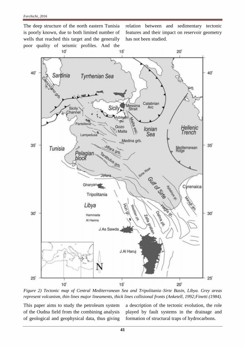
Study area is located in the Gulf of Hammamet,
located in the northeastern -part of Tunisia, 80
km east of the city of Nabeul (Cap Bon) and 30
km SW of the Italian island of Pantelleria,
covering an area of 420 km2 an average water-
depth of about 300 meters. Geologically, the
study area is located astride a deformed area of
the Tunisian Atlasic to the north and the
Pélagian sea, characterized by rifts even
continental rifts (Corti et al., 2006; Capitano al.,
2011; Belguith et al., 2013) (Fig. 1). The
continental rift of Pantellaria belonging to the
Sicilian Channel is located adjacent NE of the
study area. Study area is characterized by faults
and folds with a NE-SW trend and grabens NW-
SE trend (Fig. 2).
Figure 1) Structural map of the Sicilian-Tunisian Strait (Casero and Roure, 1994). Study area is indicated
by an orange square.
Ferchichi, 2016
41
The deep structure of the north eastern Tunisia
is poorly known, due to both limited number of
wells that reached this target and the generally
poor quality of seismic profiles. And the
relation between and sedimentary tectonic
features and their impact on reservoir geometry
has not been studied.
Figure 2) Tectonic map of Central Mediterranean Sea and Tripolitania–Sirte Basin, Libya. Grey areas
represent volcanism, thin lines major lineaments, thick lines collisional fronts (Anketell, 1992;Finetti (1984).
This paper aims to study the petroleum system
of the Oudna field from the combining analysis
of geological and geophysical data, thus giving
a description of the tectonic evolution, the role
played by fault systems in the drainage and
formation of structural traps of hydrocarbons.
Journal of Tethys: Vol. 4, No. 1, 039–054 ISSN: 2345–2471 ©2016
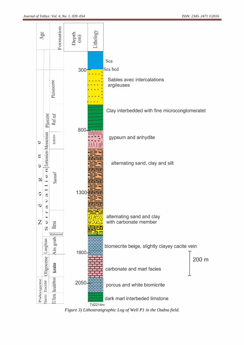
Figure 3) Lithostratigraphic Log of Well P1 in the Oudna field.

Ferchichi, 2016
43
The geological study Well data were correlated
in order to map the lateral and vertical
distribution of the analysed stratigraphic series.
The geophysical study involved the
interpretation of seismic lines identifying the
major reflectors corresponding to the formations
tops. In the second step we characterize on
seismic the major faults and trying to define
their influence on the structuring of the area, the
migration and trapping of hydrocarbons.
2- Methods
This study, based on the seismic interpretation
of sections calibrated with data from wells
which consist of lithostratigraphic logs from
five wells that have reached the Jurassic Nara
formation, allows following the lateral and
vertical variation of sedimentary series, to
determine the tectonics effect and reconstruct
during of geological time, structural evolution in
the study area. The third type of data to be used
is the borehole logging data which indicates the
basic parameters in the Serravalian Formation
as the porosity (fluid-filled portion of the rock);
the water, oil and gas saturations and the
vertical extent of a productive hydrocarbon
zone, or net pay In fact, with the seismic
interpretation technique, we can better
understand the nature of the identified tectonic
event and its impact on the formation of
hydrocarbon traps through the fault planes.
3- Geological and geophysical data
3.1- Lithostratigraphic analysis of the study
area
Lithostratigraphic data, presented in this work,
are derived from five wells that have reached
the Jurassic Nara Formation, as the older series
(outside the Oudna permit). In the Oudna
permit, five wells (P1 (2214 m), P2 (2080 m),
P3 (1640 m), P4 (1708 m) and PN (2343 m))
(Fig. 3) crossed the sedimentary following
series, from the oldest to the youngest (Fig. 4):
Figure 4) Lithostratigraphic log correlation between wells along north to south profile (in the Oudna field,
reference= 0 marine).
-El Haria Formation (Paleocene-Middle
Maastrichtian) is composed of a marl facies
dark gray clay, rich in formanifera of the
Globorotalia velascoensis species is plentiful
(Burrollet, 1956);

Journal of Tethys: Vol. 4, No. 1, 039–054 ISSN: 2345–2471 ©2016
- The Boudabbous Formation (Ypresian) is
formed of porous white biomicrite, micrite
brown clay and beige biomicrite, rich in-
Globigerinae and Globorotaliae (Tayech, 1991);
- The Ketatna Formation (Oligocene) is
represented by a carbonate facies with algea and
large benthic foraminifera such as Nummilites,
Echinoids and Pectinidae. (Bismuth, 1973);
- Ain Ghrab Formation (Langhian) is formed
of a sandy-carbonate facies (Burollet, 1956);
- The Mahmoud Formation (Upper Langhian)
is clayey and is traversed by all wells its
thickness does not exceed some meters
(Burollet, 1956);
- The Birsa Formation (Serravallian) is
composed of a sandy facies interbedded with
clay and it is recognized in the wells in the Gulf
of Hammamet at varying depths of 1423 m (P4)
to 1720.80 m (P2). It is the lateral equivalent of
the Beglia Formation outcropping in Cap Bon
(Ben Salem, 1992). Its good petrophysical
parameters (porosity of approximately 25% and
permeability is about 1 darcy) and its position
relative to the impermeable seal layer, make it a
very important reservoir of the petroleum
system in the Gulf of Hammamet in general and
in the Oudna field in particular;
- The Saouaf Formation (Serravallian p.p. –
Lower Tortonien) is represented by gray clays,
beige to brown, flaky, fine to medum- grained
sand rich in lignite (Bismuth, 1984);
- The Belkhdim Formation (Messinian) is
formed by lagunal-lacustrine deposits including
clay-carbonate and evaporate facies (Bismuth,
1984);
- Raf Raf Formation(Pliocene) is represented by
clayey deposits (Burrollet, 1956).
In Figure 4 the lithostratigraphic correlation of
wells PN, P2, P3, P1 and P4, oriented NW to SE
shows that:
•The Oligocene (Ketatna Formation) is reached
in well P1, P2, P3 and PN. It is 40 m thick in the
center (P2) and 160 m SE (P1) and deepens
towards NW;
•The presence of volcanic rock between the
Oligocene and lower Langhian in the center of
the study area (P2);
•Langhian (Ghrab Ain Formation) is reached
only in well P1, P2 and PN. It is 50 m thick in
the NW (PN) and 200 m in the SE (P1) and
deepens towards the NW;
•The top Langhian (Mahmoud Formation) is
traversed by all wells. Its thickness is almost
constant and deepened to 2000 m to NW (PN);
•The Serravallian (Birsa Formation) is an
important thickening and reaching 660 m NW
(PN). Therefore, in the northwest sector, this
formation is deeper than the previous
formations indicating subsidence invesion;
The Serravallian p.p - Lower Tortonien (Saouaf
Formation) is traversed by all wells has a very
important thickness up to 955 m NW (PN);
•The Messinian (Belkhdim Formation) unlike
the previous two ages, it thickens to the south
east (260 m in P3), which could indicate a
second inversion in the subsidence.
The NW side of study area presents an
important thickness of Miocene Deposits (Birsa
and Saouaf Formations), reveals that this area is
a subsidente area at Post Langhian (Mahmoud
Formation).
In addition (Fig. 4), this correlation shows that
the tectonic played an important role in the
distribution of deposits in the geological
periods. Indeed, subsidence during the Middle
Miocene in the NW part was probably induced
by normal faulting located between P1 and P3
and between P2 and PN.
3.2- Interpretation of seismic data
The geophysical data used are of two types:
eighteen (18) 2D seismic lines for a total length
of 698 km and distributed in a mesh of 0.5 * 0.5
km2 (Fig. 5) with a poor to medium quality,
petrophysical well-logs such us GR, sonic,
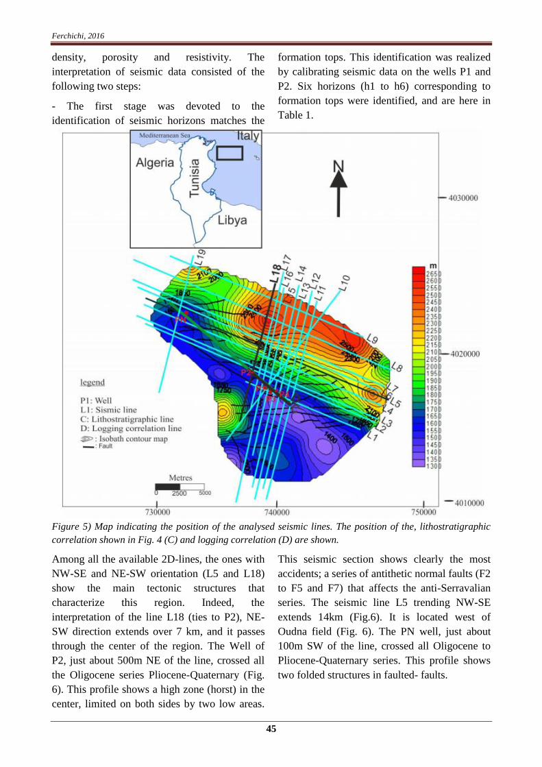
Ferchichi, 2016
45
density, porosity and resistivity. The
interpretation of seismic data consisted of the
following two steps:
- The first stage was devoted to the
identification of seismic horizons matches the
formation tops. This identification was realized
by calibrating seismic data on the wells P1 and
P2. Six horizons (h1 to h6) corresponding to
formation tops were identified, and are here in
Table 1.
Figure 5) Map indicating the position of the analysed seismic lines. The position of the, lithostratigraphic
correlation shown in Fig. 4 (C) and logging correlation (D) are shown.
Among all the available 2D-lines, the ones with
NW-SE and NE-SW orientation (L5 and L18)
show the main tectonic structures that
characterize this region. Indeed, the
interpretation of the line L18 (ties to P2), NE-
SW direction extends over 7 km, and it passes
through the center of the region. The Well of
P2, just about 500m NE of the line, crossed all
the Oligocene series Pliocene-Quaternary (Fig.
6). This profile shows a high zone (horst) in the
center, limited on both sides by two low areas.
This seismic section shows clearly the most
accidents; a series of antithetic normal faults (F2
to F5 and F7) that affects the anti-Serravalian
series. The seismic line L5 trending NW-SE
extends 14km (Fig.6). It is located west of
Oudna field (Fig. 6). The PN well, just about
100m SW of the line, crossed all Oligocene to
Pliocene-Quaternary series. This profile shows
two folded structures in faulted- faults.

Journal of Tethys: Vol. 4, No. 1, 039–054 ISSN: 2345–2471 ©2016
Figure 6a) Interpretation of seismic line L18 calibrated by well P2.b) Interpretation of seismic line L
It shows two sets of reverse faults: the SE side,
with the F1 and F2 faults which dip to the SE
and NW side, the F3 faults dip to the SE. F2 and
F3 faults have affected all horizons Raf Raf
(Pliocene), Belkhdim (Messinian), Saouaf
(Serravallian p.p-lower Tortonian), Birsa
(Serravalian), Ain Grab (Langhian) and Ktetna
(Oligocene). The fault F1 affected only a Birsa
and Saouaf Layers.

Ferchichi, 2016
47
Table 1) Results of the seismic line L18 to well P2 ties.
Well P2 data Seismic line L18 data
Formation Top depth(m) Horizon Two _way time
(ms)
Sub_ sea
(m)
Raf Raf 297 h6 363 272
Belkhdim 799,99 h5 908,304 774,99
Saouaf 979,987 h4 1046,94 954,982
Birsa 1720,81 h3 1638,29 1695,81
Ain Ghrab 1842,14 h2 1732,44 1817,14
Ketatna 1941,86 h1 1823,25 1916,86
- The second stage is devoted to monitoring
these horizons on all the seismic lines and the
establishment of the isobaths and isopachs
contour map (h3) of Birsa Formation
(Serravalian) (Figs.7 and 8).
Figure 7) Isobath map of top Serravallian reservoir, Birsa formation (contour lines every 50 m).
The contours map in the top of the Birsa
formation (Fig. 7) shows that the surveyed area
has three areas at different depths: the low area
(AB) is located north, next lengthened a NW-SE
direction and has a significant depth of 2650 m
to the north. The high area (AH) is located in
the south east, is elongated in the NW-SE
direction and has an elevation up to 1200 m to
the southeast. The latter has in its southwestern
part a gradual deepening reaching 2200m (AI).
Moreover, the survey area is affected by fault
systems. Those of NW-SE are normal and those
of NE-SW to W- E are reversed. The normal

Journal of Tethys: Vol. 4, No. 1, 039–054 ISSN: 2345–2471 ©2016
faults led to the structuring of the region horst
(central zone) and grabens (eastern zone), as
tilted blocks.
The isopachs map of Birsa formation (Fig. 8)
shows a thikness of 750 m in the north-west and
an area with a thickness of 600 m located in the
north and elongated in a direction NW- SE. A
general thinning (150m) can be observed in the
northeast and also in the northwestern part of
the study area.
Figure 8) Isopach map of the Serravallian reservoir (Birsa formation) (contour lines every 50 m).
3.3- Interpretation of borehole logging data
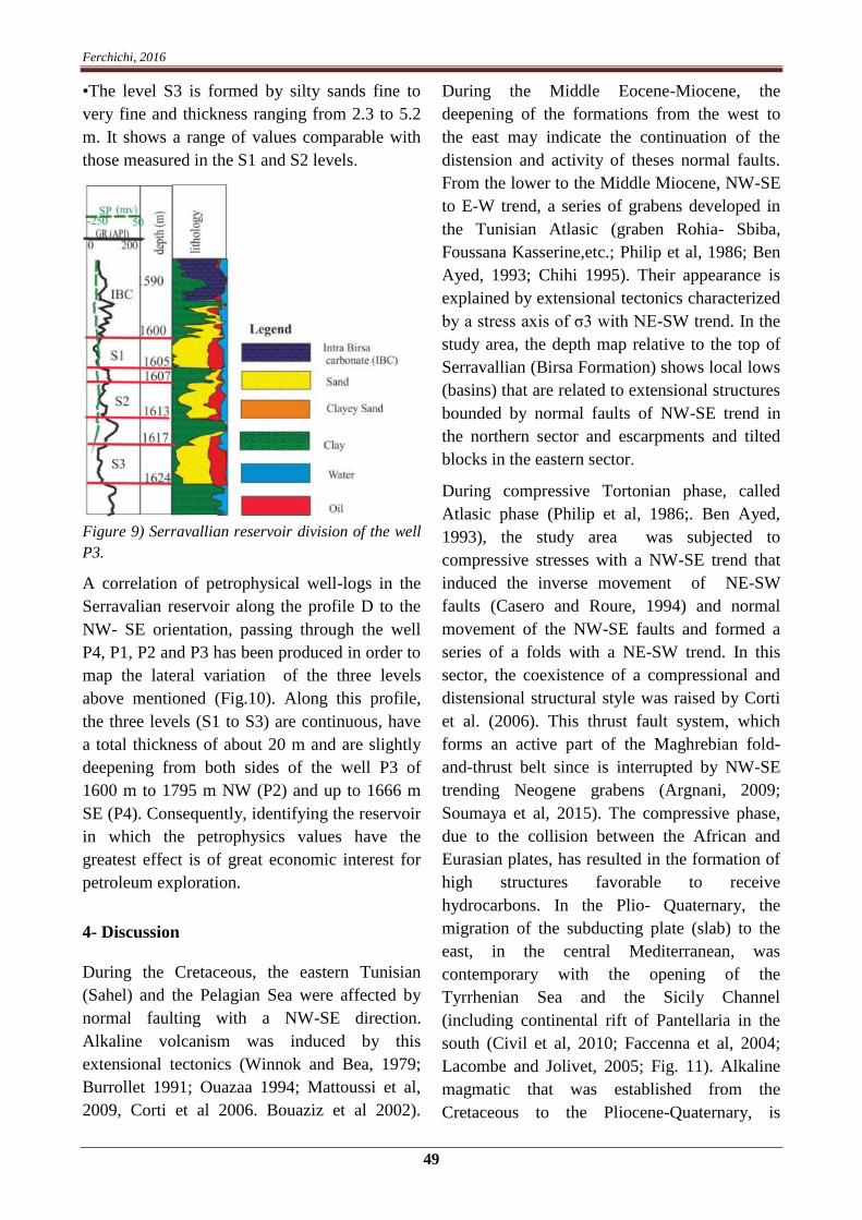
The borehole logging records in the well P3
(Fig. 9), shows that the lower member of
Serravallian (lower Birsa) can be divided into
the following three levels, from top to bottom:
•The level S1 is constituted by sand
impregnated with oil and a thickness ranging
from 0.4 to 6.2 m. It shows low GR values to
medium (30 to 40 API) that reflect a weak
presence of clays and a high value of resistivity
(1000 Ω.m) confirming the presence of
hydrocarbon. The average porosity of S1 is of
the order of 28% and its average water
saturation is 46.33%;
•The sand level S2 is constituted by sand to very
slightly fine clayey and thickness ranging from
1.4 to 9.1 m. It has a low value of GR (30 API)
indicates the absence of clay, high neutron
porosity value (20%), low density (1.95g/cm3),
with an average porosity of 26% and an average
water saturation 43%;
Ferchichi, 2016
49
•The level S3 is formed by silty sands fine to
very fine and thickness ranging from 2.3 to 5.2
m. It shows a range of values comparable with
those measured in the S1 and S2 levels.
Figure 9) Serravallian reservoir division of the well
P3.
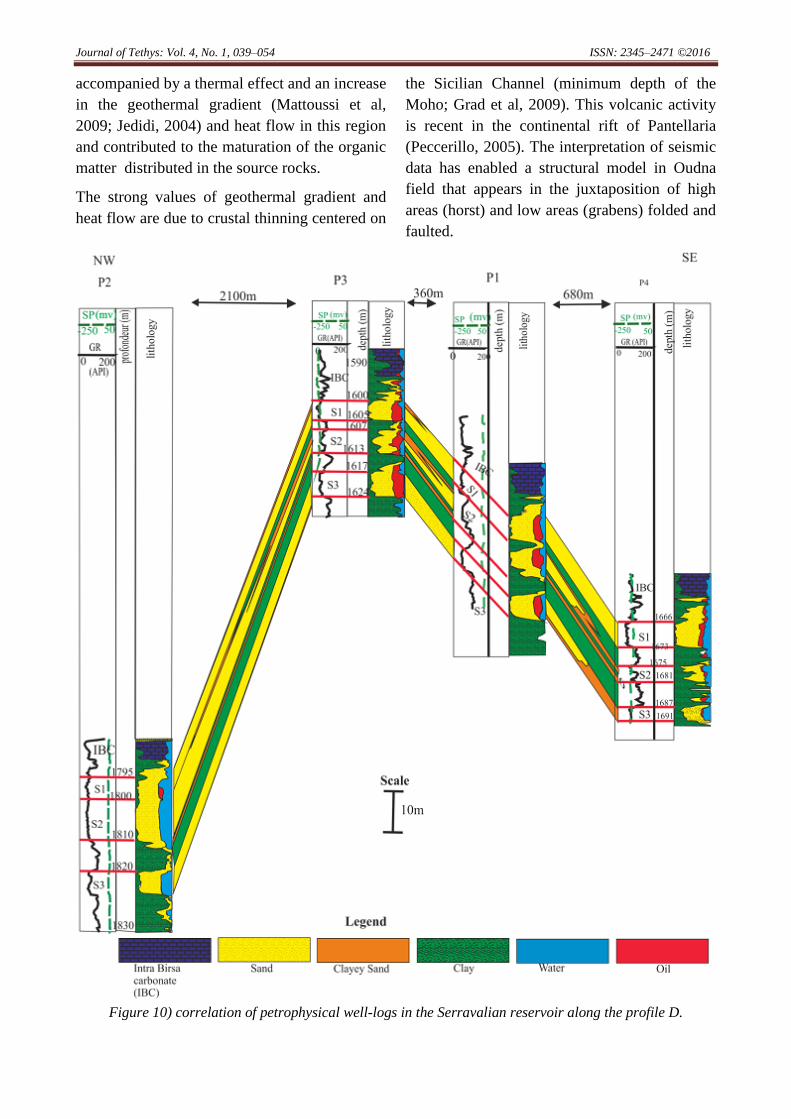
A correlation of petrophysical well-logs in the
Serravalian reservoir along the profile D to the
NW- SE orientation, passing through the well
P4, P1, P2 and P3 has been produced in order to
map the lateral variation of the three levels
above mentioned (Fig.10). Along this profile,
the three levels (S1 to S3) are continuous, have
a total thickness of about 20 m and are slightly
deepening from both sides of the well P3 of
1600 m to 1795 m NW (P2) and up to 1666 m
SE (P4). Consequently, identifying the reservoir
in which the petrophysics values have the
greatest effect is of great economic interest for
petroleum exploration.
4- Discussion
During the Cretaceous, the eastern Tunisian
(Sahel) and the Pelagian Sea were affected by
normal faulting with a NW-SE direction.
Alkaline volcanism was induced by this
extensional tectonics (Winnok and Bea, 1979;
Burrollet 1991; Ouazaa 1994; Mattoussi et al,
2009, Corti et al 2006. Bouaziz et al 2002).
During the Middle Eocene-Miocene, the
deepening of the formations from the west to
the east may indicate the continuation of the
distension and activity of theses normal faults.
From the lower to the Middle Miocene, NW-SE
to E-W trend, a series of grabens developed in
the Tunisian Atlasic (graben Rohia- Sbiba,
Foussana Kasserine,etc.; Philip et al, 1986; Ben
Ayed, 1993; Chihi 1995). Their appearance is
explained by extensional tectonics characterized
by a stress axis of σ3 with NE-SW trend. In the
study area, the depth map relative to the top of
Serravallian (Birsa Formation) shows local lows
(basins) that are related to extensional structures
bounded by normal faults of NW-SE trend in
the northern sector and escarpments and tilted
blocks in the eastern sector.
During compressive Tortonian phase, called
Atlasic phase (Philip et al, 1986;. Ben Ayed,
1993), the study area was subjected to
compressive stresses with a NW-SE trend that
induced the inverse movement of NE-SW
faults (Casero and Roure, 1994) and normal
movement of the NW-SE faults and formed a
series of a folds with a NE-SW trend. In this
sector, the coexistence of a compressional and
distensional structural style was raised by Corti
et al. (2006). This thrust fault system, which
forms an active part of the Maghrebian fold-
and-thrust belt since is interrupted by NW-SE
trending Neogene grabens (Argnani, 2009;
Soumaya et al, 2015). The compressive phase,
due to the collision between the African and
Eurasian plates, has resulted in the formation of
high structures favorable to receive
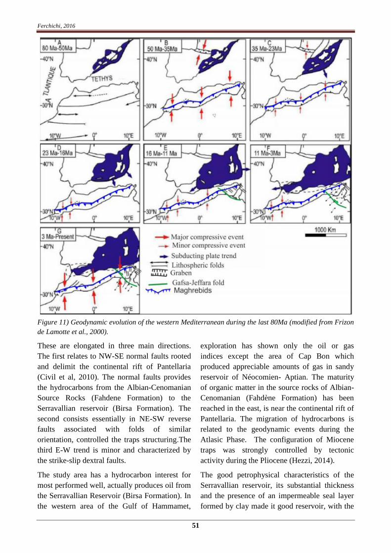
hydrocarbons. In the Plio- Quaternary, the
migration of the subducting plate (slab) to the
east, in the central Mediterranean, was
contemporary with the opening of the
Tyrrhenian Sea and the Sicily Channel
(including continental rift of Pantellaria in the
south (Civil et al, 2010; Faccenna et al, 2004;
Lacombe and Jolivet, 2005; Fig. 11). Alkaline
magmatic that was established from the
Cretaceous to the Pliocene-Quaternary, is
Journal of Tethys: Vol. 4, No. 1, 039–054 ISSN: 2345–2471 ©2016
accompanied by a thermal effect and an increase
in the geothermal gradient (Mattoussi et al,
2009; Jedidi, 2004) and heat flow in this region
and contributed to the maturation of the organic
matter distributed in the source rocks.
The strong values of geothermal gradient and
heat flow are due to crustal thinning centered on
the Sicilian Channel (minimum depth of the
Moho; Grad et al, 2009). This volcanic activity
is recent in the continental rift of Pantellaria
(Peccerillo, 2005). The interpretation of seismic
data has enabled a structural model in Oudna
field that appears in the juxtaposition of high
areas (horst) and low areas (grabens) folded and
faulted.
Figure 10) correlation of petrophysical well-logs in the Serravalian reservoir along the profile D.
Ferchichi, 2016
51
Figure 11) Geodynamic evolution of the western Mediterranean during the last 80Ma (modified from Frizon
de Lamotte et al., 2000).
These are elongated in three main directions.
The first relates to NW-SE normal faults rooted
and delimit the continental rift of Pantellaria
(Civil et al, 2010). The normal faults provides
the hydrocarbons from the Albian-Cenomanian
Source Rocks (Fahdene Formation) to the
Serravallian reservoir (Birsa Formation). The
second consists essentially in NE-SW reverse
faults associated with folds of similar
orientation, controlled the traps structuring.The
third E-W trend is minor and characterized by
the strike-slip dextral faults.
The study area has a hydrocarbon interest for
most performed well, actually produces oil from
the Serravallian Reservoir (Birsa Formation). In
the western area of the Gulf of Hammamet,
exploration has shown only the oil or gas
indices except the area of Cap Bon which
produced appreciable amounts of gas in sandy
reservoir of Néocomien- Aptian. The maturity
of organic matter in the source rocks of Albian-
Cenomanian (Fahdène Formation) has been
reached in the east, is near the continental rift of
Pantellaria. The migration of hydrocarbons is
related to the geodynamic events during the
Atlasic Phase. The configuration of Miocene
traps was strongly controlled by tectonic
activity during the Pliocene (Hezzi, 2014).
The good petrophysical characteristics of the
Serravallian reservoir, its substantial thickness
and the presence of an impermeable seal layer
formed by clay made it good reservoir, with the

Journal of Tethys: Vol. 4, No. 1, 039–054 ISSN: 2345–2471 ©2016
major structural traps associated with tight
faults with a general NE-SW trend.
4-Conclusion
The compilation of seismic and geological data
(derived from wells) license Oudna allowed the
characterization of the petroleum system of the
area and especially the Serravallian reservoir
(the Birsa Formation). It shows that this
formation constitutes a reservoir
compartmentalized into high and low blocks, by
faults activated and / or reactivated during the
Tortonian compression which is characterized
by a compression axis with NW-SE trend. Study
area and its surroundings, which form a
complex tectonic domain characterized by
grabens limited by NW-SE to N-S normal
faults, NE-SW reverse faults, and E-W trend
striking faults. These structures, originated
during late Miocene, are reactivated according
the same directions during the NNW-SSE
compressive Quaternary episode.
This structuring has controlled the variations of
thickness and depth of the sedimentary series,
especially the Birsa reservoir and the
hydrocarbon migration from Albian-
Cenomanian source rocks to the Serravallian
reservoir in this field. In the identified potential
prospects, the trap type is structural and
associated with tight NE-SW trending faults.
The obtained results are a priori a solid basis for
the development of the field and its surrounding
on the optimization of a possible operation of
Serravallian reservoir in this field. This
optimization could be consolidated a posteriori
by the performing the new wells for exploration
and / or exploitation and acquisition of new
seismic data resolution.
References
Argnani, A. 2009. Evolution of the southern
Tyrrhenian slab tear and active tectonics
along the western edge of the Tyrrhenian
subducted slab.Geological Society, London,
Special Publications: 311, 193–212.
Bédir, M. 1988. Géodynamiques des bassins
sédimentaires du sahel de Mahdia (Tunisie
orientale) de l’aptien à l’actuel. Sismo-
tectonique et structurale. Répercussion
pétrolière et sismique.- thèse de spécialité,
univ. Tunis II. , Rev. Sci. Terre, Tunisie, V,
242 p.
Belguith Y., Geoffroy, L., Mourgues, R.,
Rigane, A. 2013. Analogue modelling of
Late Miocene–Early Quaternary continental
crustal extension in the Tunisia–Sicily
Channel area, Tectonophysics: 608, 576–
585.
Ben Ayed, N. 1993. Evolution Tectonique de
l’Avant-pays de la Chaîne Alpine de Tunisie
du Début du Mésozoïque à l’Actuel.Annuaire
des Mines et Géologie, Tunisie: 32, 286 p.
Ben Salem, H. 1992. Contribution a` la
connaissance de la Géologie du Cap Bon:
Stratigraphie, tectonique et sédimentologie-
Thèse de 3e cycle, Fac. Sci. Tunis, 102 p.
Billi, A., Faccenna, C., Bellier, L., Minelli, G.
Neri, C., Piromallo, D., Presti, D., Scrocca,
D., Serpelloni, E. 2011. Recent tectonic
reorganization of the Nubia-Eurasia
convergent boundary heading for the closure
of the western Mediterranean.Bulletin de la
Société Géologique de France: 182, 279–
303.
Bouaziz, S., Barrier, E., Soussi, M., Turki, M.
M., Zouari, H. 2002. Tectonic evolution of
the northern African margin in Tunisia from
paleostress data and sedimentary
record.Tectonophysics: 357, 227–253.
Burollet, P.1991. Structures and tectonics of
Tunisia.Tectonophysics: 195, 359–369.
Capitano, A., Faccena, C., Funiciello, R.,
Salvini, F. 2011. Recent tectonics of
Tripolitania, Libya: an intraplate record of
Mediterranean subduction. Geological

Ferchichi, 2016
53
Society, London, Special Publications: 357,
319–328.
Casero, P., Roure, F. 1994. Neogene
deformations at the Sicilian–North African
plate boundary, in Peri-Tethyan Platforms.
Editions Technip, Paris: 27–50.
Chihi, L. 1995. Les fossés Néogènes à
quaternaires de la Tunisie et de la mer
pélagienne, leur étude structurale et leur
signification dans le cadre géodynamique de
la méditerranée centrale.- Thèse de doctorat
d’Etat, Faculté des sciences de Tunisie, 324
p.
Civile, D., Lodolo, E., Accettella, D., Geletti,
R., Ben-Avraham, Z., Deponte, M., Facchin
L., Ramella, R., Romeo, R. 2010. The
Pantelleria graben (Sicily Channel, central
Mediterranean): An example of intraplate
“passive” rift. Tectonophysics: 490,173–183.
Corti, G., Cuffar, M., Doglioni, C., Innocenti,
F., Manetti, P. 2006. Coexisting geodynamic
processes in the Sicily channel. Geological
Society of America, Special Paper: 409, 83–
96.
Faccenna, C., Piromallo, C., Crespo-Blanc, A.,
Jolivet, L., Rossetti, F. 2004. Lateral slab
deformation and the origin of the western
Mediterranean arcs. Tectonics: 23, 1–21.
Frizon de Lamotte, D., Bezar, B.S., Bracène,
R., Mercier, E.2000. The two main steps of
the Atlas building and geodynamics of the
western Mediterranean.Tectonics: 19,740–
761.
Grad, M., Tiira, T. 2009. The Moho depth map
of the European Plate.Geophysical Journal
International: 176, 279–292.
Hezzi, I. 2014. Caractérisation géophysique de
la plateforme de Sahel,Tunisie nord orientale
et ses conséquences géodynamiques.- Thèse
de Doctorat en sciences géologiques, Faculté
des Sciences de Tunis, Université de Tunis
El Manar II, 205p.
Jedidi, A. 2004. Modélisation de bassins
sédimentaires pour l’évaluation du potentiel
pétrolier : application au Golfe de
Hammamet-Tunisie.- thèse de doctorat.
Ecole Nationale d’Ingénieurs de Sfax. 204p.
Jolivet, L., Brun, J. P., Meyer, B., Prouteau, G.,
Rouchy, J. M., Scaillet, B. 2008.
Géodynamique Méditerranéenne. Société
géologique de France -Vuibert, 216 p.
Lacombe, O., Jolivet, L. 2005. Structural and
Kinematic relationships between Corsica and
the Pyrenees-Provence domain at the time of
Pyrenean orogeny.Tectonics: 24, 1–20.
Laridhi Ouazaa, N. 1994. Etude minéralogique
et géochimique des épisodes magmatiques
mésozoïques et miocènes de la Tunisie.-
Thèse de Doctorat es-sciences géologiques,
Faculté des Sciences de Tunis, Université de
Tunis El Manar II, 426 p.
Mattoussi Kort, H., Gasquet, D., Ikenne, M.,
Laridhi Ouazaa, N. 2009. Cretaceous crustal
thinning in North Africa: Implications for
magmatic and thermal events in the Eastern
Tunisian margin and the Pelagian Sea.
Journal of African Earth Sciences: 55, 257–
264.
Philip, H., Andrieux, J., Dlala, M., Chihi, L.
1986. Evolution tectonique mio-plio-
quaternaire du fossé de Kasserine (Tunisie
centrale). Implication sur l’évolution
géodynamique récente de la Tunisie. Bulletin
de la Société Géologique de France: 8, 559–
568.
Peccerillo, A. 2005. Plio-Quaternary volcanism
in Italy. Petrology, Geochemistry,
Geodynamics. Springer Verlag, 365 p.
Shell Tunirex. 1978. Detailed marine seismic
reflexion survey Oudna and Birsa structure. -
Rapport interne. Tunisie. 126 p.
Soumaya, A., Ben Ayed, N., Delvaux, D.,
Ghanmi, M. 2015. Spatial variation of
present-day stress field and tectonic regime

Journal of Tethys: Vol. 4, No. 1, 039–054 ISSN: 2345–2471 ©2016
in Tunisia and surroundings from formal
inversion of focal mechanisms: Geodynamic
implications for central Mediterranean.
Tectonics: 34, 1154–1180.
Winnock, E., Bea, F. 1979. Structure de la mer
Pélagienne.Géologie Méditerranéenne, La
Mer Pélagienne: tom VI, 35–40.