the rapid pliocen-quaternery subsidence of south … · the rapid pliocen-quaternery subsidence of...
TRANSCRIPT
The rapid Pliocen-Quaternery subsidence of South Caspian Basin
caused by subduction of its crystalline basement
P.Z. Mammadov1
Azerbaijan State Oil and Industry University, Baku, Azerbaijan [email protected]
ABSTRACT
The South Caspian Basin is one of the deepest buried sedimentary basins in the world. It encompasses the entire deep-water, southern part of the Caspian Sea and adjacent onshore areas of Kura trough in the west and The West-Turkmenia trough in the east. According to opinions of majority of researchers (Zonenshine et al.,1990; Mamedov P.Z. 2008; Brunet et al.,2005) South Caspian Basin is a relic of Great Caucasus - South Caspain backarc marginal basin (GCMB) incipient during Middle- Jurassic time (Bajocian - Bathonian stages) on the active Meso-Tethys margin. It differs from the other deepwater land-locked and marginal basins of the world by a number of parameters. The South Caspian Basin has the thickest (6-8 km) ocean type solid crust (SC) and the thickest sedimentary overburden (25-32km) that is, characterized by the lowest longitudinal wave average (2.0-4.2km\sc) velocity, against 4.0-5.5km\sc in other sedimentary basins.
In most sedimentary basins of the world a relationship between sedimentary succession/solid crust thicknesses appears to be around 0.8-1.2, whereas only in South Caspian Basin this ratio is measured around 3-4. Pliocene-Quaternary deposit thickness amounts to 10-12 km that exceeds 40% of sedimentary overburden deposited for the last 5.5 Ma. Herewith, thickness of the main hydrocarbon charged formation of Lower Pliocene, otherwise Productive Series - Red Color Series (5.1-2.6 Ma) amounts to 7-8 km. The time span when Productive Series- Red Color Series have been accumulated is less than 1/80 part of the basin total evolution history or almost 1-1.2% of Alpine cycle (180 Ma) duration in the region. Due to the rapid subsidence of the basin solid crust basin floor, porous Pliocene formations, dominantly sands/shales, have preserved its reservoir quality.
* Professor

1. INTRODUCTION
The South Caspian Basin originated within Arabic - EuroAsia collision zone is bounded by adjacent mountain systems like Great Caucasus, Kopetdagh, Talish and Alborz. On the north it borders with Skythian- Turan Epi-Hercinian platform. Geologic/geophysical studies indicate that South Caspian Basin is closely associated with region-wide and collision structural features. Rapid subsidence during Later Ce- nozoic time and post-Pliocene deformation are the primary challenges of the South Caspian evolution history.
Evolution history of a basin requires restoration of a basement subsidence. Three key aspects of a sedimentary basin evolution involve: 1) tectonic motions of the earth crust that led to the relief formation to favor erosion and depositional processes; 2) eustatic sea level fluctuation (or relative sea level fluctuition); 3) rock erosion, se-diments transportation and their deposition.
Subsidence of a basement and sea level fluctuation generate accommodation space that could be filled by sediments. The way and rate of accommodation space are defined by depositional processes, and first of all by sediment influx.
2. MODELING OF SOUTH CASPIAN BASIN TECTONIC SUBSIDENCE
Recently, South Caspian Basin subsidence history has been simulated by several geoscientists based on deep exploration wells spudded within the basin itself and on its margins, as well as on outcrop data. Subsidence modeling has been carried out with applied back stripping analysis (Stickler and Watts 1978). The main point of the method is as follows: if you know a position of a basement top or say of any other interface in a well or in outcrop you could subsequently “unload” or remove overburden of the overlying layers (that in its turn causes its ascending movement), taking into account sediment compaction while their burial. Overburden that exerts basement subsidence can be defined through proceeding from formation thickness and volume weight which alters while sediment burial compaction through time. In order to define basement occurrence depth (or any other interface) one might use well data, lithology, paleogeographic and paleotectonic as well as some other data (Guidish et.al., 1984). Back stripping analysis has provided curves reflecting basement subsidence history. They also enable to get some other characteristics. Most important of them is tectonic subsidence. It is common knowledge that basement subsidence is a result of two exerted factors –1) thermo-mechanical processes (endogenous factor) and 2) overburden force (exogenic factor). In order to calculate tectonic subsidence magnitude one should define what is the share of subsidence that falls on overburden.
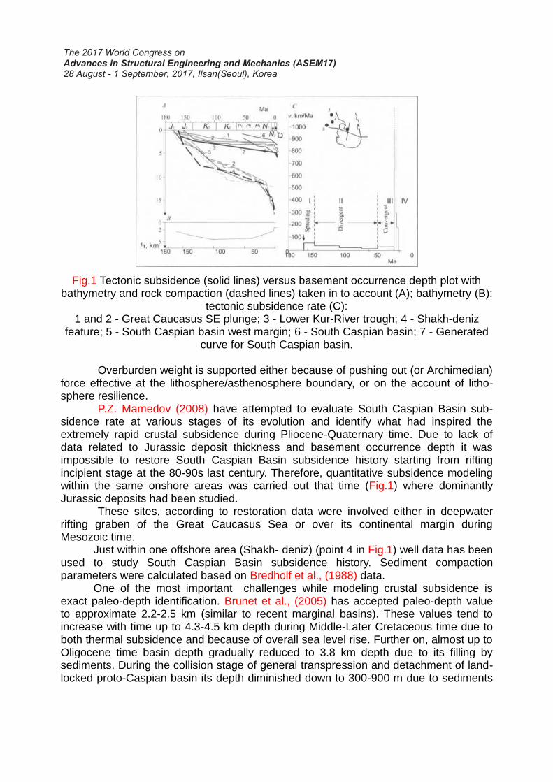
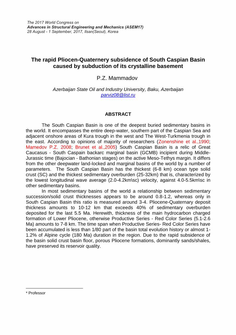
Fig.1 Tectonic subsidence (solid lines) versus basement occurrence depth plot with bathymetry and rock compaction (dashed lines) taken in to account (A); bathymetry (B);
tectonic subsidence rate (C): 1 and 2 - Great Caucasus SE plunge; 3 - Lower Kur-River trough; 4 - Shakh-deniz
feature; 5 - South Caspian basin west margin; 6 - South Caspian basin; 7 - Generated curve for South Caspian basin.
Overburden weight is supported either because of pushing out (or Archimedian)
force effective at the lithosphere/asthenosphere boundary, or on the account of litho-sphere resilience.
P.Z. Mamedov (2008) have attempted to evaluate South Caspian Basin sub-sidence rate at various stages of its evolution and identify what had inspired the extremely rapid crustal subsidence during Pliocene-Quaternary time. Due to lack of data related to Jurassic deposit thickness and basement occurrence depth it was impossible to restore South Caspian Basin subsidence history starting from rifting incipient stage at the 80-90s last century. Therefore, quantitative subsidence modeling within the same onshore areas was carried out that time (Fig.1) where dominantly Jurassic deposits had been studied.
These sites, according to restoration data were involved either in deepwater rifting graben of the Great Caucasus Sea or over its continental margin during Mesozoic time.
Just within one offshore area (Shakh- deniz) (point 4 in Fig.1) well data has been used to study South Caspian Basin subsidence history. Sediment compaction parameters were calculated based on Bredholf et al., (1988) data.
One of the most important challenges while modeling crustal subsidence is exact paleo-depth identification. Brunet et al., (2005) has accepted paleo-depth value to approximate 2.2-2.5 km (similar to recent marginal basins). These values tend to increase with time up to 4.3-4.5 km depth during Middle-Later Cretaceous time due to both thermal subsidence and because of overall sea level rise. Further on, almost up to Oligocene time basin depth gradually reduced to 3.8 km depth due to its filling by sediments. During the collision stage of general transpression and detachment of land-locked proto-Caspian basin its depth diminished down to 300-900 m due to sediments
influx with concomitant shelf slope formation.
Fig. 2 Regionwide seismic-stratigraphic section along sub-latitudinal (a) and meridional
(b) lines (Mamedov, 1991, 2006)
Fig.1.a displays plots of tectonic subsidence and basement subsidence, caused by overburden and water column, as well as variation of bathymentry and tectonic subsidence rate. These plots has been compiled based on 1-D synthetic models-pseudo-sections for several sites, particularly for points 1 and 2 within Great Caucasus plunging site, point 3 within Lower Kur-River basin and point 4 - Shakh-daniz.
Correlation of these pseudo sections (Fig.2) has been carried out based on stratigraphic section compiled by author.
According to a general model (Fig.1) compiled by P.Z.Mamedov (2008) who used seismi-stratigraphic section (Fig.2 a) a newly generated of the GCMB during Later Jurassic time (165-145 Ma) had subsided down by 1.2 km at 59- 60 m/Ma rate due to extension and thermal subsidence process.

Fig. 3 The image of thin oceanic consolidated type crust of the South-Caspian Basin in
the time seismic section
Taking into account isostatic load of overburden and 2.5-3.5 km of water column it has been identified that total crustal subsidence approximates up to 6.0 km by Jurassic time termination.
During Early Cretaceous time (145-97 Ma) basin crust subsided just by 0.9 km at 15-20 m/Ma rate only due to thermal subsidence. However making allowance for overburden and water column weight it was inferred that the earth crust was exerted additional 1.5 km of subsidence, so total subsidence approximates to 7.5 km. During Later Cretaceous time (97-70 Ma) the earth crust had subsided even more slower (10- 18 m/Ma) with tectonic component measured 0.8 km plus overburden exerted 1.5 km subsidence.
So, the earth crust of the basin had subsided just by 2.9-3.1 km and making allowance for overburden total subsidence amounts to 9.5 km. Seismic stratigraphic sections indicate that total thickness of Mesozoic deposit (Fig.2) within Mid-South Caspian Basin does not exceed 4-6 km. This maximum thic-kness up to 8-10 km is observed within Absheron sill. It was identified that terregenous
Fig.3. The image of thin oceanic consolidated tyoe crust of the South Caspian Depression in the time sections
deposits, even at shallow depth ranges (5-6 km), had undergone compaction of no less than 1.5-2.0 fold, whereas at 15-20 km depth almost 3 fold because of isostatic pressure and overburden (Guidish et.al., 1984).
Sedimentary basin remained quite deep during Paleo-Eocene time (66-36 Ma) when its extension actually became suspended. Tectonic subsidence slowed down to 5-8 m/Ma. It is common knowledge that during first two evolution stages (rifting - arc-island extension) of the back-arc basin its crustal subsidence happened basically due to speculative assumption and acquired data about crustal subsidence of recent marginal basins.
Acquired data indicates that during Oligocene-Early Miocene time South Caspian basin crust underwent relatively slow tectonic subsidence due to increased overburden which thickness approximated to 14-16 km. That time the basin depth had gradually reduced due to extensive sediment influx. Later Miocene tectonic subsidence plots indicate an abrupt decline down to 2 km, whereas tectonic subsidence rate in-creased up to 600-2000 m/Ma.
Crustal subsidence range calculated for the northern part of South Caspian Basin near Absheron sill making allowance for overburden and water column value during Pliocene-Quaternary time makes significant value up to 10-12 km. Rapid cumulative crustal and tectonic subsidence along with paleotectonic backward analysis using region-wide seismic\stratigraphic sections of the basin subsidence within east Major Caucasus basin where its relic –South Caspian basin was incipient, enable to identif four basic stages (Fig. 1,c).
First spreding stage: Mid - Later Jurassic syn-rifting subsidence stage of marginal basin at the 50-60 m/Ma rate. The second divergent stage of arc Island extension (Cretaceous-Eocene) when marginal basin underwent slow thermal subsi-dence. During that stage the basin was filled by dominantly deepwater deposits (shale, carbonate shale, turbidites) along with condensed sheets
At the third convergent stage - transpressional stage (Oligocene-Miocene) when basin undergoes slow tectonic subsidence, crustal subsidence was exerted by the virtue of massive influx of terregenoes, basically shale sand overburden.
The fourth shrinking stage is the period of extreme rapid subsidence during Pliocene-Quaternary time when land-locked basins undergo transpression.
Subsidence rate within South Caspian Basin northern part at that Pliocene stage was 15-20 fold grater (600-200 m/Ma) compared to the rifting incipient stage and thermal subsidence of newly generated crust up to Cretaceous time (Fig.1,b) and by order of magnitude (100-200 fold) greater than during Cretaceous and Paleogene time.
These figures are unique and in this regard South Caspian Basin has no alternative worldwide. Here, emerges one question, what kind of extraordinary geologic event might cause an abrupt and impressive subsidence during Pliocene Quaternary time?
Standard models of tectonic subsidence even with overburden taken into account could not account for the cause of such rapid and extensive subsidence of South Caspian Basin crust during the last 5.5Ma. There have been several options related to this issue. One of them is rapid subsidence of both South Caspian Basin and Black Sea Basin associated with a “sudden” crustal subsidence along the bordering faulting systems during Pliocene time. However, there is no evidence of such faults

existence observed on high-resolution seismic sections that might have caused 10-12 km deep crustal subsidence of South Caspian Basin during Pliocene-Quaternary time. There are convincing signs of subsidence accommodated deposition of Pliocene seismic unit with their mites and horizons thickness increment trend towards the basin center where total Pliocene thickness averages 6-7 km with its base subsided down to 10-13 km during that time (Fig. 3). Due to the second option, basin subsidence is supposed to be driven by the solid crustal transtensional processes at recent time. Geodynamic condition of the region precludes resurgence of crust spreading and rifting subsidence of a solid crust and a relatively cool crustal blocks underneath the South Caspian Basin. Low heat flow and crustal neutral seismicity appears to have eliminated this option, too.
Fair correlation of geological events that took place almost synchronously and unusually quickly rise and thrust of mountains, extreme reduction of dimensions of depression and abrupt subsidence of the bottom, extra-avalanche sedimentation) indicates to a strong geodynamic factor acting on the crust in the area of convergence of the plates. This factor induces unusual reaction of a thin-oceanic consolidated crust of depression. In the zone of contact of this crust with a thick continental crust of the platform, with different rheology and lithology, actions of colossal compressing forces from the south and huge isostatic load from above resulted in subduction that was a starting “pulse" for abrupt subsidence of sedimentary formations and subsequent events.
Subduction of consolidated crust of depression is clearly seen on the models prepared with the use of data of ultra-deep seismometry (common depth point), seismotomography seismology and gravimetry (Fig. 4 and 5).
Fig. 4 The image of the Southern of ep-Hercynian platform and subducting oceanic type crust of South Caspian Basin.

Fig.5 Illustration of subsidence and subduction stages of SCB oceanic crust under the influence of geodynamic compression regime and the overburden pressure.
3. ANALYSIS OF FEASIBLE REASONS OF SOUTH CASPIAN BASIN RAPID SUBSIDENCE Brunet at al., (2005, 2013, 2013) consider one of the feasible causes of rapid subsidence during Pliocene-Quaternary time as bending effect of increasing transpression upon the basin lithosphere. The point of an offered mechanism is the effect of initial bending stage of elastic plate respond on external force similar to that of lithosphere as a whole. In order to calculate effective thickness of lithosphere along the basin longitudinal section a special algorithm has been used. South Caspian Basin lithospheric section has been simulated based on P.Z.Mamedov (2006, 2012).
Simulated South Caspian Basin overburden was assumed to be around 25 km thick, and a solid crust 10 km thick. Transpressional tension equating to the fold of 25 of typical interplate stress had caused just 2- 3 km subsidence. Such magnitude of South Caspian Basin crustal subsidence was sufficient to fill the basin with additional 2-
3 fold of sediment influx (that is, in the range of 4-8 km thick, making allowance for sediment compaction and basin depth shallowing from 2.5-3.0 km depth in Miocene down to 0.5-1.0 km during Quaternary time). Geophysical data acquired recently, from South Caspian Basin survey along with geologic/geophysical intelligence related to structural evolution of the region shed light on the basin rapid subsidence as a result of subduction process P.Z. Mamedov, (2005, 2012).
According to some geoscientists Caucasus - South Caspian sector of AGPP is referred to the long lived subduction zones where Tethys and Meso-Tethys closure signs are witnessed. Intracontinental subduction zone in these segment has been traced based on region-wide seismic tomography data. Zonen-shine et al., (1990) and others assume that South Caspian Basin and adjacent areas are precisely the areas where several ancient and recent subduction zones have been encipient and evolved. He considers that within the juncture of TransCaucasus and Euro-Asia plates during orogenic stage there appear to have generated an Amshtuts typte intraplate subduction zone slopping down to the north. According in P.L. Zonenshine et al., (1990) an extensive sive underthrust of Transcaucasul microcontinent had happened at 6-7sm\yr rate. The undertrust intensity significantly decreased during Oligocene-Miocene and its rejuvenation resumed by Later Miocene-Early Pliocene. Was suggested that most subduction zones slopping down under Great Caucasus was kept live up to Quaternary time. Increasingly, subduction processes might have resumed within collision zone of South Caspian and Epi-Hercinian platform at the extremely trans- pressional stage. South Caspian solid crust subduction beneath the platform has been displayed in several sketches and models built up based on seismology, gravimetry (Granath et al., 2000), as well as a result of paleogeographic analysis.
Some of these concepts are very simplified and heuristic. Of all available South Caspian basin crustal models,. (Fig.2 b, 3) are justified based on actually reliable data of ultra-seismic long record Common Depth Point (CDP) data (16-20\sec) that provide picturesque information related to solid crust geometry, its thickness and geologic setting. A long record (CDP) reflection survey carried out over the conjunction zone, where South Caspian basin abuts Epi-Hercinian platform, has revealed that ocean type crust plunges down to the north with superimposed swell and a mosaic of basalt layer squash above (accretion prism), that along with other available data (gravimetry witnessing about deficit of dense masses, seismology supplying data about deep-seated earthquake focuses around Absheron sill ) are the convincing arguments for South Caspian basin crustal subduction verification. Submitted subduction model is one of interplate tectonic models of the region evolution. Fig. 6 shows subduction oceanic crust of SCB and deep-seated earthquakes focuses around Absheron sill.

Fig. 6 Illustration of subduction oceanic crust of SCB and deep-seated earthquakes focuses around Absheron sill.
4. CONCLUSIONS
That might be a result of extra ordinary event happened in the region that had
been exerted by a strong geodynamic process as convergent of plates to cause the ocean crus respond within a contact zone will thick continental crust of the plat form with different lithology and rheology.
Increasing transpressional strew exerted from the south and vertical force caused by overburden served as a threshold mechanism of the crustal abrupt subsidence and it! subduction under the platform It is1 just that very case when subduction might have caused abrupt sea floor subsidence at the Pliocene onset Alternative geodynamic process enable to cause such interrelated even except subduction is unimaginable.
Good correlation of extra ordinary geologic events happened almost simultaneously in extremely rapid pace (extensive emergence o mountain systems, overthrust and diapirism, basin shrinking and rapid subsidence, avalanche sedimentation) during the last 5.5 Ma in the region witness that all these events had been entailed by the same geologic event, that is, a crustal transpression that triggered subduction and sea floor subsidence that was most extensive in its northern

part. Modelling suggest that it is possible to account for the observed pattern of
subsidence and sedimentation in the South Caspian Basin by a process of sediment loading and compaction on a thermally-subsiding, later Mesozoic crust . Analysis of earthquake focal mechanisms and epicenter depths show that the north ern margin of the basin, the Absheron Ridge is characterized by deep earthquakes at depths down to 90 km. These deep earthquakes have been interpreted to result from the subduction of South Caspian oceanic crust beneath the Absheron Ridge.
REFERENCES
Brunet M.F., Barrier R., Egans., Mamedov P.Z. (2005). “Tectonic and subsidence evolutions of the South Caspian Basin marines in Iran and Azerbaijan”. Abstract book V International Conference “Petroleum geology and hydrocarbon potential of Caspian and Black Seas region”, Baku, 87-89 Brunet. M.F., Ershov A.V., Mamedov P.Z., Kangarli T. (2013). “Mezozoic subsidence history of the Kura-Caspian Basin”. Darius programme, Eastern Black-Sea- Caucasus Workshop, 24-25 June 2013. Tbilisi, Georgia Brunet. M.F., Ershov A.V., Mamedov P.Z., Kangarli T. (2013). “Evolution of basins from Kura to Amu Darya”. Darius programme. Central Asia workshop, 26-27 February 2013, Bonn-Company Bredehoeft, J.D., Djevanshir, R.D., Belitr, K.R. (1988). “Lateral fluid flow in a compaeting sand-shale seqvence: South Caspian Basin”. American Association of Petroleum. Geologists Bulletin, Vol. 72, 416-424 Guidsh T.M. et. al. (1984). “Relationship between constatic sea level change and basement subsidence”. Bull, America. Petrol. Geology. Mamedov P.Z (2008). “Driving mechanism of South Caspian Basin Rapid Subsidence”. Azerbaijan Oil Industry, Vol. 1, 7-19 Mamedov P.Z., Mamedova L.P. (2012). “Earth Crust Structure of The Southern and Middle Caspian Sea in the light of new seismic studies”. The modern problems of geology and geophysics of eastern Caucasus and the south Caspian depression. 34th International Geological Congress, 251-258 Steekler, M.S., Watts, A.B. (1978). “Subsidence of the Atlantic type continental marigin off New York”. Earth and planetary Science Letters, Vol. 41, 1-13 Zonen-shine L.P., et. al. (1990). “Tectonic of the litosphhere plates of the USSR”. Books 1 and 2. Nauka, Moscow.