the rise of citizen science they walk among us · · 2016-08-26the rise of citizen science they...
TRANSCRIPT
August 2016 Journal of the Institutionof Environmental Sciences
The rise of citizen science T H E Y W A L K A M O N G U S T H E R I S E O F C I T I Z E N S C I E N C E
2 | environmental SCIENTIST | August 2016
CASE STUDY 12 Bat Detective: citizen science for eco-acoustic biodiversity monitoringRory Gibb, Oisin Mac Aodha, and Kate E. Jones describe how improvements in technology are enabling the public to assist in monitoring global bat populations using sound.
CASE STUDY 18The impact of citizen science on research about artificial light at nightSibylle Schroer, Oscar Corcho and Franz Hölker highlight the negative impact of artificial light at night and how society can help to reduce it.
FEATURE 42 Building a new biodiversity data infrastructure to support citizen scienceRachel Stroud and Ella Vogel introduce the new and emerging, Atlas of Living Scotland, as the future template for UK wide data infrastructure for biodiversity.
ANALYSIS 74 Data quality in citizen scienceYolanda Wiersma, Jeffrey Parsons and Roman Lukyanenko discuss the findings of their research into how data quality can be improved for participants of citizen science.
August 2016 | environmental SCIENTIST | 3
INTRODUCTION 4 Citizen Science – where has it come from? Dominic Sheldon and Robert Ashcroft explore the history of citizen science, and ask what challenges it faces today, and where it might be going.
CASE STUDY 25 Marine debris data: turning scuba divers into citizen scientists Domino Albert enlightens us about how the global issue of marine litter is being tackled by scuba diving enthusiasts.
ANALYSIS 32The motivations of volunteers in citizen science Gitte Kragh discusses the motivations that drive volunteers to participate in citizen science. CASE STUDY 36The riverfly monitoring initiative: structured community data gathering informing statutory response Daniele Di Fiore and Ben Fitch take us through the history of this monitoring initiative and how it makes possible, through public participation, the resolution of local environmental problems with local knowledge.
CASE STUDY 48Sustainable travel plans in primary schools Lindsey Coates shows us how the power of education can influence the habits of pupils and their community in tackling local air pollution.
FEATURE 56Citizen observatories for effective Earth observations: the WeSenseIt Approach 'Suvodeep Mazumdar et al. describe how “citizen observatories” have been created with the help of new technology to allow the public to collaborate with authorities and organisations in day to day and emergency water management issues.
FEATURE 62 Promoting freshwater sustainability through citizen science Steven Loiselle describes the success of FreshWater Watch in generating public engagement and harnessing their skills to improve their local waterways.
CASE STUDY 67 Drought Risk and You: engaging citizen scientists in drought researchEmma Weitkamp, Natasha Constant, Sarah Ayling and Lindsey McEwen discuss the benefits of engaging local communities with scientific research to combat drought and water shortage.
The Journal of the Institutionof Environmental Sciences
Volume 25 No 2ISSN: 0966 8411 | Established 1971
The environmental SCIENTIST examines major topics within the field of environmental sciences, providing a forum for experts, professionals and stakeholders to discuss key issues.
Views expressed in the journal are those of the authors and do not necessarily reflect IES views or policy.
Published byThe Institution of Environmental Sciences3rd Floor 140 London Wall, London, EC2Y 5DN
Tel 020 7601 1920Email [email protected] www.the-ies.org
Editor Robert Ashcroft Subeditor Paula Gilfillan
Cover design Kate Saker Designer Kate Saker Limited katesaker.co.ukPrinters Lavenham Press Ltd
CONTENTS >
Environmental science lags way behind the traditional sciences in prestige and resources. Whilst quasi-professional physicists and chemists were securing
endowments for prestigious societies in the seventeenth century, environmental science remained principally the province of rural clergymen, and later, of Victorian ladies who collected flowers. There were exceptions – the distinguished tradition of thousands of amateur rainfall observers across the UK, for example, who from the mid-nineteenth century onwards patiently and systematically centralised their daily observations into collections, eventually allowing meteorological patterns to be explored. It was only after the emergence of a range of serious environmental problems in the mid-20th century that professionalisation of the environmental sciences was prompted, and a range of environmental research institutes were established. Very quickly thereafter, career environmental scientists began to emerge, paralleled by the founding of the Institution of Environmental Sciences itself; the community of environmental managers, researchers, auditors and policymakers became largely restricted to full time experts.
However, a minor revolution has taken place in the last few years. Facilitated by the sudden availability of desktop, and latterly handheld information technologies such as Global Positioning Systems and image processing capability, environmental science is now capitalising on the talents and geographical spread of non-specialists, ‘citizens’, with spare time, curiosity and a smart phone. The potential resource available in terms of person-power has grown hugely, and using social media, persuasive researchers have been able to draw in large teams spread across huge areas. Citizen scientists have shown themselves to be competent with technologically sophisticated equipment, able to record reliably, and willing to deal openly with uncertainty in their knowledge. Where individual skills are sometimes lacking, the numerical power of Big Data analysis can be brought to bear.
The diversity of current citizen science projects is also astonishing. Intrepid volunteers are monitoring the night sky for light pollution, diving to capture the extent of oceanic plastic contamination, collecting and analysing samples of river water, and recording their experiences of flooding. Many of the research programmes are broadly ecological – monitoring and identifying bats, bees, birds, flies and slugs for
example, but citizen scientists do not have to work outdoors. Non-specialists have been trained to scan satellite imagery for wildebeests in the Serengeti, penguins in the Antarctic, and African migrant groups affected by environmental catastrophes who require emergency aid.
For research scientists wanting access to national scale monitoring, these new enthusiasts are a bonus, and for many participants the educational benefits are immediately obvious. Some are inspired to find out more about the science, and to support, or even lead, action on environmental improvements. For isolated or lonely individuals there might even be social gains in joining communities of interest.
However, these programmes are not without controversy. Environmental data may be collected, but not be effectively quality-assured or useable. It has been claimed that in some projects CV improvements, or other personal gains may be the true motivations - the benefits hence accruing mainly to the participants, rather than the science. Some commentators have alleged that poorly-informed but data-rich citizens can slow progress on complex environmental challenges by challenging policymakers inappropriately. There is also concern that future funding for environmental science could be compromised, with increasing expectation that environmental observations can always be collected by volunteers rather than paid professionals.
It remains to be seen whether ‘peak citizen science’ is being reached now, or whether interest from the public will decline, with future developments in image and sound recognition making interpretation redundant. Potentially, the growing demand from research scientists will outstrip the supply of citizen scientists, and a battle for engagement of the willing will begin. This issue of the environmental SCIENTIST should help you to decide.
EDITORIAL
Citizen science – a research revolution?
Professor Carolyn Roberts is an independent environmental consultant, specialising in water and environment, and a former Chair of the Institution of Environmental Sciences. She is the first Professor of Environment at Gresham College London, where she delivers a series of free public lectures in the City (www.gresham.ac.uk/professors-and-speakers/professor-carolyn-roberts). Listen to her ‘Life Scientific’ at www.bbc.co.uk/programmes/b07428bk.
This journal is printed on paper produced by a Programme for the Endorsement of Forest Certification (PEFC) certified supplier.
4 | environmental SCIENTIST | August 2016 August 2016 | environmental SCIENTIST | 5
INTRODUCTION INTRODUCTION
In this issue of the environmental SCIENTIST, you will find numerous examples of exciting, cutting-edge citizen science. But to really understand why this
form of science has gained such prominence in recent years, we need to explore its history and definition. What does citizen science actually mean, and where has it come from? One cannot answer the question of what citizen science is without first exploring the origins of our current conception of the term “scientist”, so let’s start there.
WHAT IS A SCIENTIST? For the vast majority of modern human history the concept of the professional “scientist” just didn’t exist1. Charles Darwin had no formal training in science. He studied divinity with the aim of becoming a cleric; biology was a hobby he practiced alongside this pursuit that ended up proving rather productive for him! Before 1833, even the word “scientist” didn’t exist2. Once this concept did begin to develop, science became clearly framed as a pursuit for a particular, educated elite. As a report for the European Commission by the University of the West of England’s Science Communication Unit, explained: “It is the professionalisation of science that has led to the exclusion of citizens”2.
It is widely documented that citizens have recorded and analysed natural phenomena for the sake of their profession for millennia, whether it’s vintners recording grape harvest days for more than six centuries3 (a scientific practice now known as oenology), court diarists in Kyoto recording dates of the cherry blossom for 1200 years4, or farmers in the United States keeping phenological records of the “Timing of important agronomical events, such as sowing, harvests, and pest outbreaks”5, which are today some of the oldest, continuous, organised datasets. So, although these record keepers would not have
recognised the terminology citizen science, it is clearly not a new phenomenon. On the other-hand it may be experiencing somewhat of a renaissance, undeniably thanks to modern technology.
WHAT IS CITIZEN SCIENCE?So what is citizen science today? If only this were as simple a question to answer as it sounds. There are many competing definitions and typologies of what citizen science is, or more specifically what falls onto the spectra of what citizen science is and who is a citizen scientist.
In terms of straightforward definitions, Miller-Rushing et al. state that citizen science is simply “The engagement of non-professionals in scientific investigations”1, whatever form this involvement takes. It is the nature of this involvement however, where it gets messy. The reason it can be messy is that the context and scale of this engagement varies broadly.
Citizen Science – where has it come from?
© Yasushitanikado | Dreamstime
Dominic Sheldon and Robert Ashcroft explore the history of citizen science, ask what challenges it faces today, and where it might be going.
6 | environmental SCIENTIST | August 2016 August 2016 | environmental SCIENTIST | 7
INTRODUCTION INTRODUCTION
The simplest of typologies breaks citizen science down into three categories: contributory, collaborative and co-created6, where a citizen’s involvement in the various stages of a scientific investigation dictates their classification (contributory involves least involvement and co-created, the most).
Haklay goes one step further (literally) with a four level classification7 which extends Bonney et al.’s model6
at either end, by defining the least involvement as “crowdsourcing” and the opposing end, completely independent action, as “extreme citizen science”. How the latter fits into this world more generally is something that is explored later on.
BOX 1: COINING THE TERM CITIZEN SCIENCE
“The term ‘citizen science’ was coined by the social scientist Alan Irwin in his 1995 book, Citizen Science6, in which he describes how people accumulate knowledge in order to learn about and respond to environmental threats. Irwin was concerned with the uncertainty of scientific knowledge and contended that alternative forms of knowledge – such as those constructed by ‘lay publics’ – can and should be considered as complementary”2.
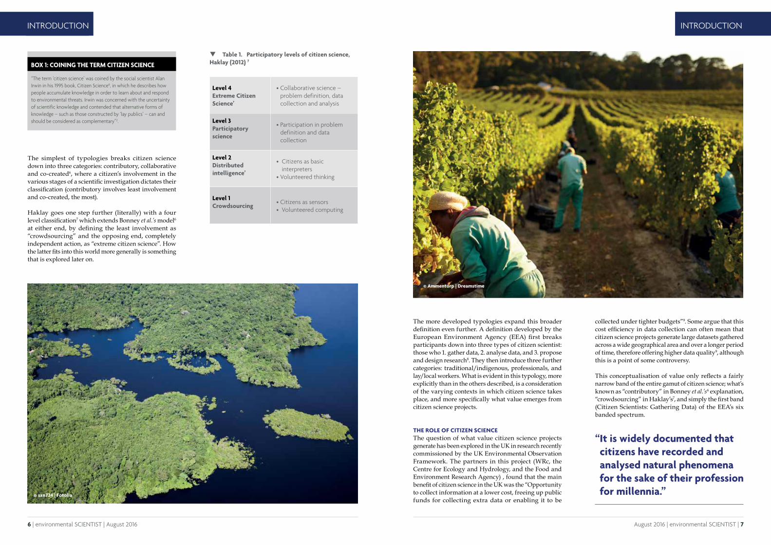
The more developed typologies expand this broader definition even further. A definition developed by the European Environment Agency (EEA) first breaks participants down into three types of citizen scientist: those who 1. gather data, 2. analyse data, and 3. propose and design research8. They then introduce three further categories: traditional/indigenous, professionals, and lay/local workers. What is evident in this typology, more explicitly than in the others described, is a consideration of the varying contexts in which citizen science takes place, and more specifically what value emerges from citizen science projects.
THE ROLE OF CITIZEN SCIENCEThe question of what value citizen science projects generate has been explored in the UK in research recently commissioned by the UK Environmental Observation Framework. The partners in this project (WRc, the Centre for Ecology and Hydrology, and the Food and Environment Research Agency) , found that the main benefit of citizen science in the UK was the “Opportunity to collect information at a lower cost, freeing up public funds for collecting extra data or enabling it to be
Table 1. Participatory levels of citizen science, Haklay (2012) 7
collected under tighter budgets”9. Some argue that this cost efficiency in data collection can often mean that citizen science projects generate large datasets gathered across a wide geographical area and over a longer period of time, therefore offering higher data quality9, although this is a point of some controversy.
This conceptualisation of value only reflects a fairly narrow band of the entire gamut of citizen science; what’s known as “contributory” in Bonney et al.’s6 explanation, “crowdsourcing” in Haklay’s7, and simply the first band (Citizen Scientists: Gathering Data) of the EEA’s six banded spectrum.
Level 4 Extreme Citizen Science’
• Collaborative science – problem definition, data collection and analysis
Level 3 Participatory science
• Participation in problem definition and data collection
Level 2 Distributed intelligence’
• Citizens as basic interpreters
• Volunteered thinking
Level 1 Crowdsourcing
• Citizens as sensors • Volunteered computing
“ It is widely documented that citizens have recorded and analysed natural phenomena for the sake of their profession for millennia.”
© Ammentorp | Dreamstime
© san724 | Fotolia
8 | environmental SCIENTIST | August 2016 August 2016 | environmental SCIENTIST | 9
INTRODUCTION INTRODUCTION
The other motivation often described in western literature, is that engaging individuals in scientific practice increases public understanding of science. This is notoriously difficult to measure, especially at scale. Considering citizen science is voluntary; one potential pitfall is that that volunteers generally have prior interest and connection with the subject matter, and so in terms of wider public engagement, it can be of marginal benefit.
This rationale is commonly used for larger projects, where citizen science coordinators seek to crowdsource data from a broad range of participants. This is problematic as public engagement decreases as the scale of the project increases. Effective and meaningful engagement can be difficult to achieve whilst maintaining scale. On the other hand, at a very small scale (i.e. a single classroom or community) this value has been far more clearly evidenced.
This type of citizen science, often overlooked, is a form of community-driven research, where projects are often closely linked with environmental justice movements. There are countless examples of such projects around the world. For example, Mapping for Change in London, worked with communities to gather noise pollution data from a local scrap yard. This citizen science led to political action which resulted in the removal of the scrap yard’s waste management licence10,11. In other examples from the US, communities have been driven in one case, to collect emissions data on commercial pig farms12, and in another, water quality data near sites of hydraulic fracturing2 due to concerns about the impacts of these practices on their local environment.
Critically this practice also occurs in communities outside of the global north. For example, the Achuar people of the Amazon worked with a non-governmental organisation called Amazon Watch, to document the environmentally destructive activities of an oil company in their territory13. Thanks to the science conducted by this community, the oil company abandoned its activities in Peru in 201213.
CHALLENGESThis particular kind of citizen science is often not considered in the wider western understanding of the practice largely because results are not published in the scientific literature. This exclusivity is arguably another consequence of the professionalisation of science and its effects are felt across the citizen science sphere.
One of the most common concerns, and one of the biggest challenges currently facing citizen science practitioners is the way that citizen science is considered in the wider scientific community. It has been reported that evidence provided by citizen scientists is seen as “Substandard or of doubtful quality” at times14. Theorists describe how the chaos of data collection across a large and fairly unregulated group could lead to discrepancies such as the number of days a week that two participants were able to gather data15. One example of this limitation is what is known as a “weekend bias”, where participants with full time jobs can only gather data at weekends when they have free time16.
This methodological concern can also be extended to who is able to participate, which is disproportionately skewed towards “middle class” individuals8. This is problematic when the aim is to encourage participation. More needs to be done to ensure that participation encompasses individuals from across the socio-economic spectra.
Another challenge is whether the science has any genuine impact on policy making, which “May be because it is not always clear how decisions have been made and it may be difficult to obtain concrete evidence of influence”2. Of course, this is an issue which is by no means limited to citizen science, but it does again highlight the importance of scale, where the community based examples previously discussed had a very clear legislative, litigative or economic outcome.
THE FUTURENew technologies have sparked leaps forward in the practice of science throughout history. The railroad and the telegraph advanced the frontier for weather observation networks and near-term forecasts in the US17, but what are the catalysts we can expect to revolutionise citizen science in the near future?
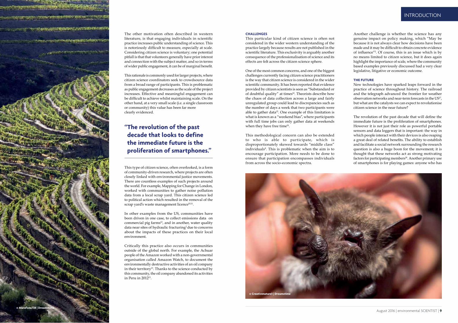
The revolution of the past decade that will define the immediate future is the proliferation of smartphones. However it is not just their role as powerful portable sensors and data loggers that is important: the way in which people interact with their devices is also reaping a great deal of related benefits. The ability to establish and facilitate a social network surrounding the research question is also a huge boon for the movement; it is thought that these networks act as strong motivating factors for participating members18. Another primary use of smartphones is for playing games: anyone who has
“ The revolution of the past decade that looks to define the immediate future is the proliferation of smartphones.”
© Marafona738 | Dreamstime
© Creativenature1 | Dreamstime

10 | environmental SCIENTIST | August 2016 August 2016 | environmental SCIENTIST | 11
INTRODUCTION INTRODUCTION
REFERENCES
1. Miller-Rushing, A., Primack, R. and Bonney, R. (2012) The history of public participation in ecological research. Frontiers in Ecology and the Environment, 10, pp. 285–290.
2. Science Communication Unit, University of the West of England, Bristol (2013) Science for Environment Policy In depth Report: Environmental Citizen Science. Report produced for the European Commission DG Environment, December 2013. http://ec.europa.eu/science-environment-policy.
3. Chuine I., Yiou P., Viovy N., Seguin. B., Daux, V. and Le Roy Ladurie, E. (2004) Historical phenology: grape ripening as a past climate indicator. Nature, 432, pp. 289–290.
4. Primack R.B., Higuchi H. and Miller-Rushing A.J. (2009) The impact of climate change on cherry trees and other species in Japan. Biological Conservation. 142, pp. 1943–1949.
5. Hopkins A. (1918) Periodical events and natural law as guides to agricultural research and practice. Monthly Weather Review, 9, pp. 1–42.
6. Bonney, R., Ballard, H., Jordan, R., McCallie, E., Phillips, T., Shirk, J., and Wilderman, C. C. (2009) Public participation in scientific research: defining the field and assessing its potential for science education. Center for Advancement of Informal Science Education (CAISE), Washington, DC.
7. Haklay, M. (2012) Citizen Science and Volunteered Geographic Information – overview and typology of participation. In: Sui D.Z., Elwood, S. and Goodchild, M.F. (eds.). Crowdsourcing Geographic Knowledge: Volunteered Geographic Information (VGI) in Theory and Practice. Springer, Berlin, pp 105-122.
8. Adem, C. (2011) Summary Report of the EEA Workshop: Lay, Local, Traditional Knowledge and Citizen Science: Their Roles in Monitoring and Assessment of the Environment. http://lltk.pbe.eea.europa.eu/about/lltk-and-citizen-science-meeting-report.pdf/download/en/1/lltk%20and%20citizen%20science%20meeting%20report.pdf [ Accessed: 16/06/2016].
9. Kaminski, I. (2016) Environmental regulators benefit from citizen science. The ENDS Report. http://www.endsreport.com/
article/52652/environmental-regulators-benefit-from-citizen-science [Accessed: 16/06/2016].
10. London Sustainability Exchange. (2013) Case study 1: Pepys Estate in London Borough of Lewisham. London Sustainability Exchange. www.lsx.org.uk/resources/CaseStudyPepys_page3194.aspx [Accessed: 16/06/2016].
11. Gura, T. (2013) Amateur Experts. Nature, 496, pp. 259-261.
12. Wing, S., Horton, R. A., Muhammad, N., Grant, G. R., Tajik, M. and Thu, K. (2008) Integrating epidemiology, education, and organizing for environmental justice: community health effects of industrial hog operations. American Journal of Public Health, 98(8), pp. 1390–1397.
13. Amazon Watch. (2013) The Achuar of Peru. Amazon Watch. http://amazonwatch.org/work/achuar [Accessed: 16/06/2016].
14. Gollan, J., De Bruyn., L. L., Reid, N. and Wilkie, L. (2012) Can volunteers collect data that are comparable to professional scientists? A study of variables used in monitoring the outcomes of ecosystem rehabilitation. Environmental Management, 50(5), pp. 969–978.
15. Miller-Rushing A.J., Inouye D.W. and Primack, R.B. (2008) How well do first flowering dates measure plant responses to climate change? The effects of population size and sampling frequency. Journal of Ecology, 96, pp. 1289–1296.
16. Courter, J.R., Johnson, R.J., Stuyck, C.M., Lang, B. A. and Kaiser, E.W. (2013). Weekend bias in citizen science data reporting: implications for phenology studies. International Journal of Biometeorology, 57, pp. 715–720.
17. Vetter J. (2011). Lay observers, telegraph lines, and Kansas weather: the field network as a mode of knowledge production. Science in Context, 24, pp. 259–80.
18. Grey, F. (2009) Viewpoint: The age of citizen cyberscience. CERN Courier, http://cerncourier.com/cws/ article/cern/38718 [Accessed: 16/06/2016].
19. Gura, T. (2013) Amateur Experts. Nature, 496, pp. 259-261.
Dominic Sheldon is the Publications and Projects Assistant at the Institution of Environmental Sciences. He holds a BSc in Environmental Sciences from the University of East Anglia and an MSc in Environmental Technology from Imperial College London. Before joining the IES he has worked and interned at the Solar Energy Industries Association, the Department of Energy and Climate Change and the United Nations Framework Convention on Climate Change Secretariat.
Robert Ashcroft is the Publications and Policy Officer at the Institution of Environmental Sciences and editor of the environmental SCIENTIST. He holds a BA in Geography from Cambridge University and an MSc in Biodiversity, Conservation and Management from Oxford University. Before joining the IES team, Robert worked as a researcher focusing on biodiversity and nature conservation at the Institute for European Environmental Policy.
ridden public transport in a large metropolitan area has most likely seen evidence of this. Some citizen science apps are using this fluency to incentivise participation19, using direct validation methods or 'gamification' (e.g. ranks, levels) to encourage continued engagement.
Less directly, apps can also use active visualisation and feedback of results to help users understand the relative value of their contribution and its place in the wider sample.
As technology continues to advance, it is likely ever more (and ever more innovative) citizen science projects will be developed to harness these new benefits. These changes will of course bring new possibilities for both communities and researchers, but also fresh challenges. As citizen science apps proliferate, how will developers make sure theirs are noticed? Will the market become saturated and public interest wane? It is probable that project developers will need to work harder to engage participants in the investigation process beyond data collection to encourage participation, and perhaps embrace and learn from the community-led projects which are demonstrating increasing success. Professional scientists will have to accept that this phenomenon is not going away, and proactively consider how it may come to interact with their work in the future. As technology continues to develop, this may throw up novel risks which the scientific community will need to mitigate against (just think about the remarkable developments in affordable drone technology!).
Finally, one of the biggest challenges for scientists will be to react to the remarkable growth in citizen science, and the volumes of data this allows the community to collect. Structures to enable this data to be usefully integrated, analysed and shared will need to be developed so as to multiply the impact of these projects. Several initiatives are currently showing great promise in this area, and it is important that innovation is promoted alongside the great strides being taken by individual projects around the world.
© sezer66 | Fotolia
12 | environmental SCIENTIST | August 2016 August 2016 | environmental SCIENTIST | 13
CASE STUDY CASE STUDY
Bat Detective: citizen science for eco-acoustic biodiversity monitoringRory Gibb, Oisin Mac Aodha, and Kate E. Jones describe how improvements in technology are enabling the public to assist in monitoring global bat populations using sound.
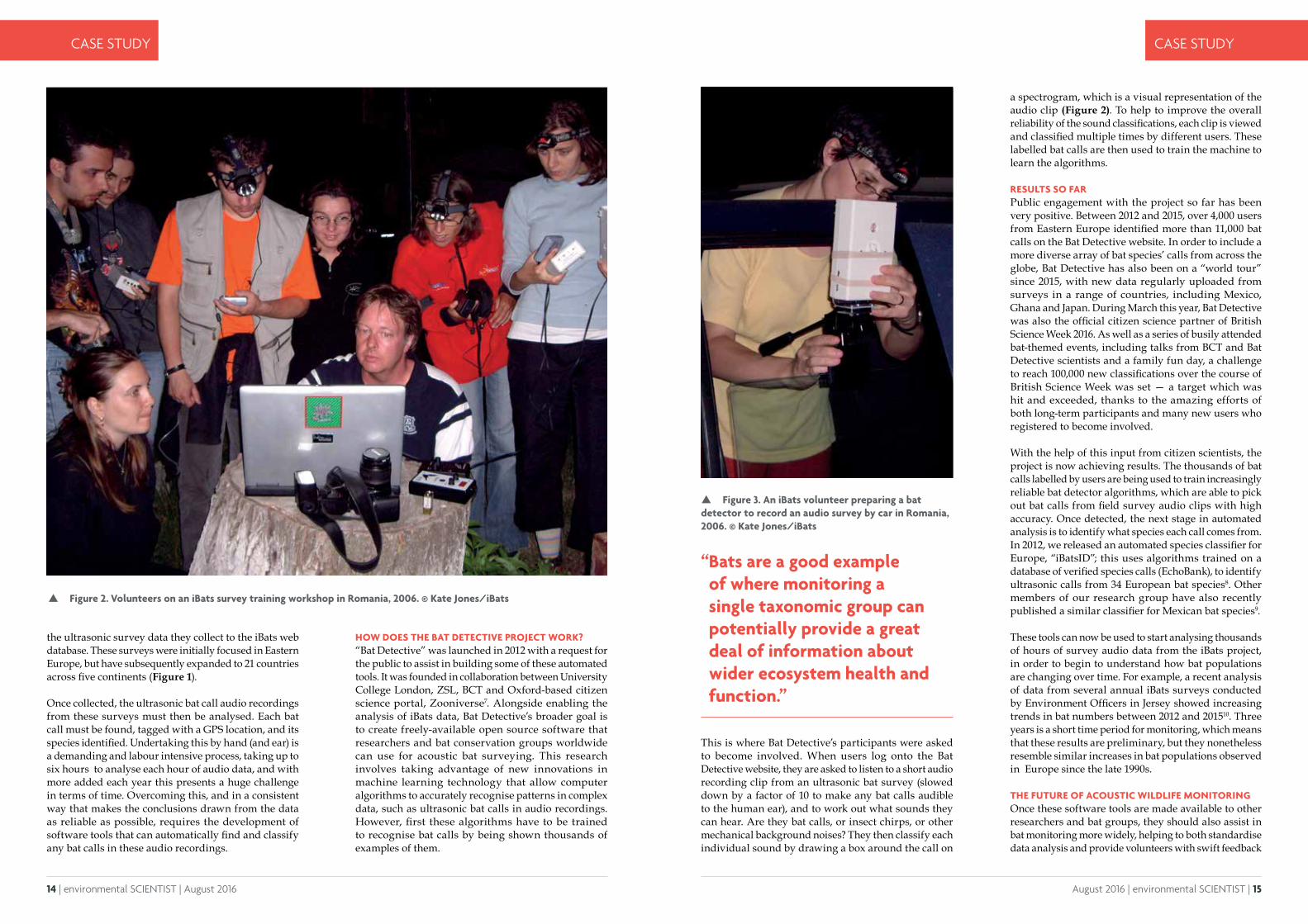
Figure 1. Global distribution of acoustic bat surveys carried out by iBats volunteers between 2006 and 2015. Map plotted using 2016 satellite data from Google Earth/TerraMetrics.
emphasised the urgent need for large-scale monitoring programmes to quantify the extent of global biodiversity loss. By assessing which species are declining and thus giving the planet’s ecosystems a health-check of sorts, we can hope to better understand the anthropogenic processes that are driving these losses, and how best to address and prevent them.
A key challenge for scientists monitoring biodiversity is the sheer investment of time and energy required to collect and analyse biological data at national and global scales. Citizen science is proving to be increasingly useful for addressing some of these problems. For example, in the United Kingdom (UK), long-running volunteer-based initiatives such as the Bat Conservation Trust’s National Bat Monitoring Programme and the British Trust for Ornithology's Breeding Bird Survey, are not only encouraging people to engage with issues relating to the environment, but are also generating very useful large-scale, multi-year datasets about trends in wildlife populations3. Long-term ecological data like
CURRENT BAT MONITORING PROGRAMMESWe live at a time of unprecedented global environmental change. Over the last century, sharp increases in the impacts of human activities have driven accelerating biodiversity loss, climate change, and degradation of natural ecosystems. The consequences are severe for many species, but also for humans, who risk losing vital services provided by healthy ecosystems, such as clean water, food and crop pollination1,2. The United Nations Convention on Biological Diversity has therefore
these are vital for understanding how different species are responding over time to environmental change, and may also be useful for predicting how they will be affected by growing issues such as climate change.
With finite resources available, what species should be monitored and why? Bats are a good example of where monitoring a single taxonomic group can potentially provide a great deal of information about wider ecosystem health and function. Bats are very sensitive to human-induced environmental changes such as habitat loss, pollution and agricultural intensification, and in the future, many species’ seasonal hibernation and migration cycles may also be affected by climate change. They also provide socio-economic benefits to humans, such as insect pest control and crop pollination. While bats are important targets for conservation in their own right, it is this sensitivity that means changes to bat populations may also function as useful bio-indicators, i.e. as early warning systems that measure how human activities are affecting biodiversity and ecosystems4. The Indicator Bats (iBats) programme and online citizen science project, Bat Detective, were founded for this reason: to establish and provide tools for a global monitoring system for bat populations. The majority of bats are small and nocturnal, making them difficult to survey by sight; however, it is possible to use sound. Most bat species continually leak information about themselves into the environment in the form of ultrasonic vocal calls, which they use to navigate the world by echolocation. These calls vary in sound and structure between bat species, and also change depending on whether an individual bat is searching for prey, feeding or interacting with other bats. This means that, although beyond the range of human hearing, by using audio sensors called bat detectors, it is possible to tune into their acoustic world and find out not only where bats are present, but what species they are, and what they are doing.
IBATS – WHAT’S THAT?iBats was established in 2006 as a collaboration between the Zoological Society of London (ZSL) and the Bat Conservation Trust (BCT), with the aim of using this acoustic approach to carry out co-ordinated, volunteer-led bat population monitoring on a global scale5,6. Since then, thousands of iBats volunteers, often in collaboration with local conservation or governmental organisations, have carried out acoustic bat surveys year-on-year using standardised methods; these involve driving cars along specified survey routes with a bat detector mounted on the roof. iBats has also released a phone app which enables volunteers to directly upload
14 | environmental SCIENTIST | August 2016 August 2016 | environmental SCIENTIST | 15
CASE STUDY CASE STUDY
the ultrasonic survey data they collect to the iBats web database. These surveys were initially focused in Eastern Europe, but have subsequently expanded to 21 countries across five continents (Figure 1).
Once collected, the ultrasonic bat call audio recordings from these surveys must then be analysed. Each bat call must be found, tagged with a GPS location, and its species identified. Undertaking this by hand (and ear) is a demanding and labour intensive process, taking up to six hours to analyse each hour of audio data, and with more added each year this presents a huge challenge in terms of time. Overcoming this, and in a consistent way that makes the conclusions drawn from the data as reliable as possible, requires the development of software tools that can automatically find and classify any bat calls in these audio recordings.
Figure 2. Volunteers on an iBats survey training workshop in Romania, 2006. © Kate Jones/iBats
Figure 3. An iBats volunteer preparing a bat detector to record an audio survey by car in Romania, 2006. © Kate Jones/iBats
HOW DOES THE BAT DETECTIVE PROJECT WORK?“Bat Detective” was launched in 2012 with a request for the public to assist in building some of these automated tools. It was founded in collaboration between University College London, ZSL, BCT and Oxford-based citizen science portal, Zooniverse7. Alongside enabling the analysis of iBats data, Bat Detective’s broader goal is to create freely-available open source software that researchers and bat conservation groups worldwide can use for acoustic bat surveying. This research involves taking advantage of new innovations in machine learning technology that allow computer algorithms to accurately recognise patterns in complex data, such as ultrasonic bat calls in audio recordings. However, first these algorithms have to be trained to recognise bat calls by being shown thousands of examples of them.
a spectrogram, which is a visual representation of the audio clip (Figure 2). To help to improve the overall reliability of the sound classifications, each clip is viewed and classified multiple times by different users. These labelled bat calls are then used to train the machine to learn the algorithms.
RESULTS SO FAR Public engagement with the project so far has been very positive. Between 2012 and 2015, over 4,000 users from Eastern Europe identified more than 11,000 bat calls on the Bat Detective website. In order to include a more diverse array of bat species’ calls from across the globe, Bat Detective has also been on a “world tour” since 2015, with new data regularly uploaded from surveys in a range of countries, including Mexico, Ghana and Japan. During March this year, Bat Detective was also the official citizen science partner of British Science Week 2016. As well as a series of busily attended bat-themed events, including talks from BCT and Bat Detective scientists and a family fun day, a challenge to reach 100,000 new classifications over the course of British Science Week was set — a target which was hit and exceeded, thanks to the amazing efforts of both long-term participants and many new users who registered to become involved.
With the help of this input from citizen scientists, the project is now achieving results. The thousands of bat calls labelled by users are being used to train increasingly reliable bat detector algorithms, which are able to pick out bat calls from field survey audio clips with high accuracy. Once detected, the next stage in automated analysis is to identify what species each call comes from. In 2012, we released an automated species classifier for Europe, “iBatsID”; this uses algorithms trained on a database of verified species calls (EchoBank), to identify ultrasonic calls from 34 European bat species8. Other members of our research group have also recently published a similar classifier for Mexican bat species9.
These tools can now be used to start analysing thousands of hours of survey audio data from the iBats project, in order to begin to understand how bat populations are changing over time. For example, a recent analysis of data from several annual iBats surveys conducted by Environment Officers in Jersey showed increasing trends in bat numbers between 2012 and 201510. Three years is a short time period for monitoring, which means that these results are preliminary, but they nonetheless resemble similar increases in bat populations observed in Europe since the late 1990s.
THE FUTURE OF ACOUSTIC WILDLIFE MONITORINGOnce these software tools are made available to other researchers and bat groups, they should also assist in bat monitoring more widely, helping to both standardise data analysis and provide volunteers with swift feedback
“ Bats are a good example of where monitoring a single taxonomic group can potentially provide a great deal of information about wider ecosystem health and function.”
This is where Bat Detective’s participants were asked to become involved. When users log onto the Bat Detective website, they are asked to listen to a short audio recording clip from an ultrasonic bat survey (slowed down by a factor of 10 to make any bat calls audible to the human ear), and to work out what sounds they can hear. Are they bat calls, or insect chirps, or other mechanical background noises? They then classify each individual sound by drawing a box around the call on
16 | environmental SCIENTIST | August 2016 August 2016 | environmental SCIENTIST | 17
CASE STUDY CASE STUDY
REFERENCES
1. Reid W.V., Mooney H.A., Cropper A., Capistrano D., Carpenter S.R., Chopra K., Dasgupta P., Dietz T., Duaiappah A.K., Hassan R., Kasperson R., Leemans R., May R.M., McMichael A.J., Pingali P., Samper C., Scholes R., Watson R.T., Zakri A.H., Shidong Z., Ash N.J., Bennett E., Kumar P., Lee M.J., Raudsepp-Hearne C., Simons H., Thonell J. and Zurek M.B. (2005) Millennium Ecosystem Assessment. Ecosystems and Human Well-Being: Synthesis. Island Press, Washington, D.C..
2. McLellan R., Iyengar L., Jeffries B. and Oerlemans N. (2014) WWF Living Planet Re-port. WWF, Gland, Switzerland.
3. Barlow K.E., Briggs P.A., Haysom K.A., Hutson A.M., Lechiara N.L., Pacey P.A., Walsh A.L. and Langton S.D. (2015) Citizen science reveals trends in bat populations: the National Bat Monitoring Programme in Great Britain. Biological Conservation, 182, pp. 14-26.
4. Jones G., Jacobs D.S., Kunz T.H., Willig M.R. and Racey P.A. (2009) Carpe noctem: the importance of bats as bioindicators. Endangered. Species Research, 8, pp. 93-115.
5. Jones K.E., Russ J.A., Bashta A., Bilhari Z., Catto C., Csosz I., Gorbachev A., Gyorfi P., Hughes A., Ivashkiv I., Koryagina N., Kurali A., Langton S., Collen A., Margeian G., Pandourski I., Parsons S., Prokofev I., Szodaray-Paradi A., Szodaray-Paradi F., Tilova E., Wal-ters C.L., Weatherill A. and Zavarzin O. (2013) The Indicator Bats program: A system for the global acoustic monitoring of bats. In: Collen B., Pettorelli N., Baillie J., Durant S. (eds.) Biodiversity Monitoring and Conservation: Bridging the Gap between Global Commitment and Local Action. Wiley-Blackwell, United Kingdom.
6. iBats, http://www.ibats.org.uk.
7. Bat Detective, http://www.batdetective.org.
8. Walters C.L., Freeman R., Collen A., Dietz C.,Fenton M.B. Jones G., Obrist M.K., Puechmaille S.J., Sattler T., Siemers B.M., Parsons S. and Jones K.E. (2012) A continental-scale tool for acoustic identification of European bats. Journal of Applied Ecology, 49, pp. 1064-1074.
9. Zamora-Gutierrez V., Lopez-Gonzalez C., Gonzalez M.C.M., Fenton B., Jones G., Kalko E.K.V., Puechmaille S., Stathopoulos V. and Jones K.E. (2016) Acoustic identification of Mexican bats based on taxonomic and ecological constraints on call design. Methods in Ecology and Evolution.
10. Hawkins C., Browning E. and Jones K.E. (2016) iBats Jersey - Review: Report for States of Jersey Department of the Environment. Centre for Biodiversity and Environment Research, University College London.
11. Blumstein D.T., Mennill D.J., Clemins P., Girod L., Yao K., Patricelli G., Deppe J.L., Krakauer A.H., Clark C., Cortopassi K.A., Hanser S.F., McCowan B., Ali A.M. and Kirschel A.N.G. (2011) Acoustic monitoring in terrestrial environments using microphone arrays: applications, technological considerations and prospectus. Journal of Applied. Ecology, 48, pp. 758–767.
Rory Gibb is a PhD student at University College London, where he works on the Bat Detective and iBats citizen science projects. He is interested in how emerging technologies like acoustic sensors and movement tags can assist in understanding human impacts on wildlife and ecosystems.
Oisin Mac Aodha is a Research Associate in the Department of Computer Science at University College London. He is interested in interactive machine learning and part of his work involves creating algorithms that can automatically classify bat species from audio recordings.
Kate Jones holds a professorial chair in Ecology and Biodiversity in the Department of Genetics, Evolution and Environment, University College London and Zoological Society of London. Her research looks at global biodiversity patterns and predicts the effects of future global change on wild nature.
on what bat species they are hearing in their local areas. Most importantly, they also represent steps towards a fully-automated system for monitoring bats through sound, which could eventually provide a software basis for automated surveys using arrays of remote microphones. Indeed, since many types of wildlife make recognisable vocal sounds — not just bats, but also birds, many other mammals and amphibians — ecologists are increasingly aware that acoustic surveys may be a useful way to study changes in ecosystems over time11. Yet as the challenges of iBats have shown, one of the major obstacles is subsequently analysing the massive amounts of resulting data. By working with computer scientists to increasingly automate this process, remote biodiversity monitoring through sound could ultimately provide one effective way to reduce the time and personnel costs associated with traditional field surveying.
Both iBats and Bat Detective offer examples of the potential for citizen science to help monitor wildlife at scales that would be challenging or unfeasible for research scientists alone. They also show that it is possible for people to get involved in ecological research in many different ways, whether through practical data collection in the field, manual data analysis, or classifying data online in order to help build more sophisticated automated research tools. Technology is a key aspect of this too; access to ever more powerful smartphones, laptops and portable devices creates a range of new possibilities for people to assist in tracking the health of the natural world. Further development
Figure 5. Spectrogram of a three-second audio clip from Bat Detective. Bat calls and other sounds show up as bright markings on the spectrogram. Bat Detective’s users listen to each clip and draw boxes (shown in blue) around each individual sound to classify them.
Figure 4. The Bat Detective website, where the public listen and classify bat calls and other sounds from clips of iBats field survey audio recordings.
of the tools to enable the public to become involved in this, will assist in the collection of long-term, large-scale data that is vital to cur-rent ecological research. But more broadly, it should also create new and accessible ways of engaging a greater number and variety of people with how and why our environment is changing, and with what measures can be taken to address those changes.
18 | environmental SCIENTIST | August 2016 August 2016 | environmental SCIENTIST | 19
CASE STUDY
The impact of citizen science on research about artificial light at nightSibylle Schroer, Oscar Corcho and Franz Hölker highlight the negative impact of artificial light at night and how society can help to reduce it.
Artificial light at night (ALAN) changes the nightscapes of the places where we live - it is the most visible pollutant of our planet. However,
ALAN is generally accepted as an indispensable tool for activity after the onset of darkness, and not perceived as a pollutant. But there are manifold reasons to consider ALAN as a disturbance for biodiversity and human wellbeing.
ALAN AS A BIODIVERSITY THREATAbout one third of today’s estimated vertebrate species and more than half of all known invertebrate species are night active1. The senses of nocturnal wildlife have adapted to their niche of low light levels. Some species are highly sensitive to light and avoid habitats, which are under the influence of artificial light. Other species are attracted to light and become easy prey, when disoriented by light sources. The habitats of light sensitive species are decreasing with increasing night-time lighting. Bats and amphibian species, for example, are 100 and over 90 per cent nocturnal, respectively1. Within these groups, a significant amount of species are critically threatened2. The extent to which ALAN influences species behaviour and habitat is today not fully understood. Many organisms are sensitive to disturbances around and below moonlight levels (< 0.3 lux)3. The brightening of the nightscapes can disturb circadian and seasonal timing or navigation, leads to disorientation, can disrupt ecological communities and food webs, cause loss of habitat for sensitive species, and consequently the loss of biodiversity.
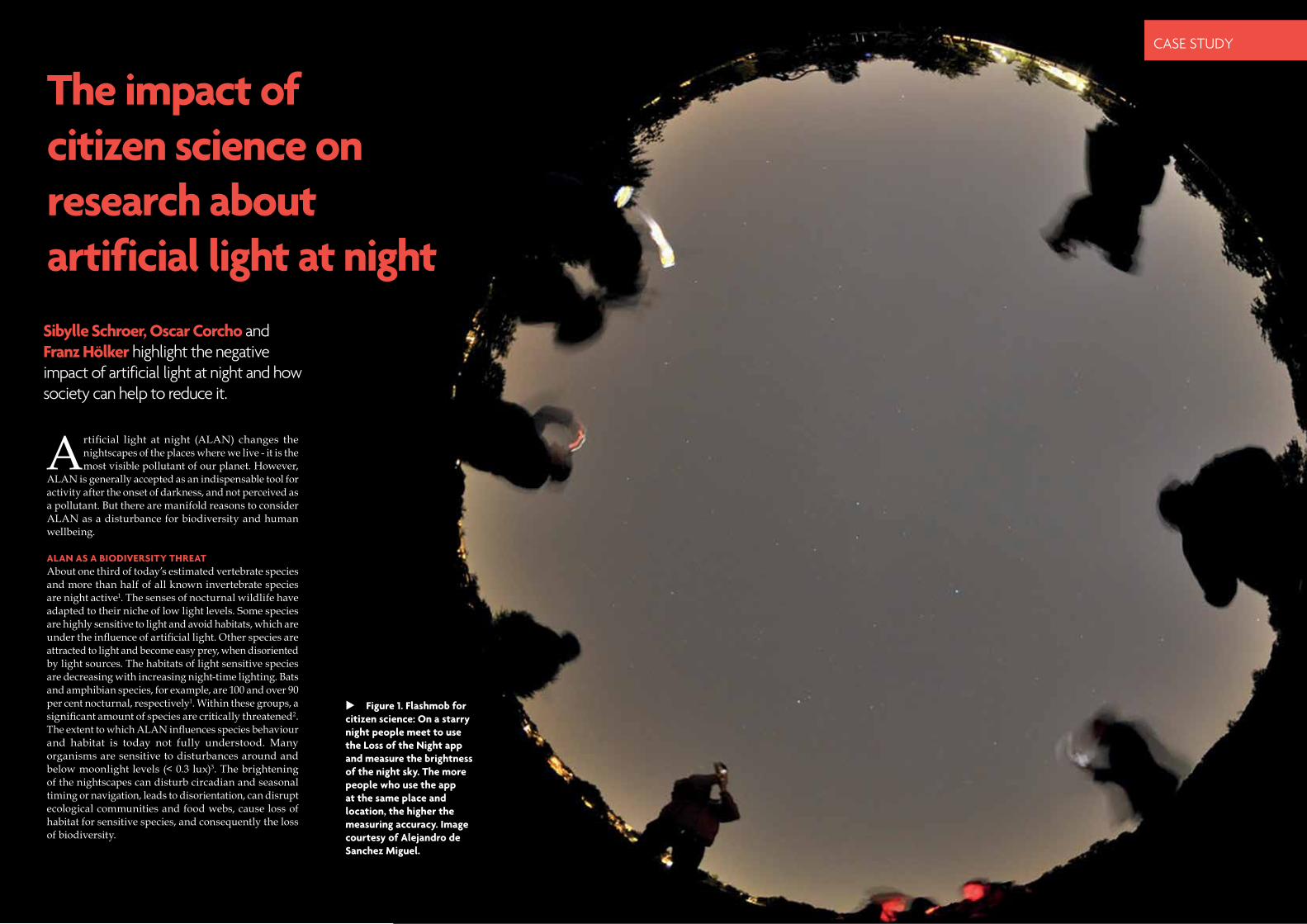
Figure 1. Flashmob for citizen science: On a starry night people meet to use the Loss of the Night app and measure the brightness of the night sky. The more people who use the app at the same place and location, the higher the measuring accuracy. Image courtesy of Alejandro de Sanchez Miguel.
CASE STUDY
20 | environmental SCIENTIST | August 2016 August 2016 | environmental SCIENTIST | 21
CASE STUDY CASE STUDY
Citizen science is an optimal instrument, as it can raise awareness of the environmental problem, but at the same time can involve the public in activism.
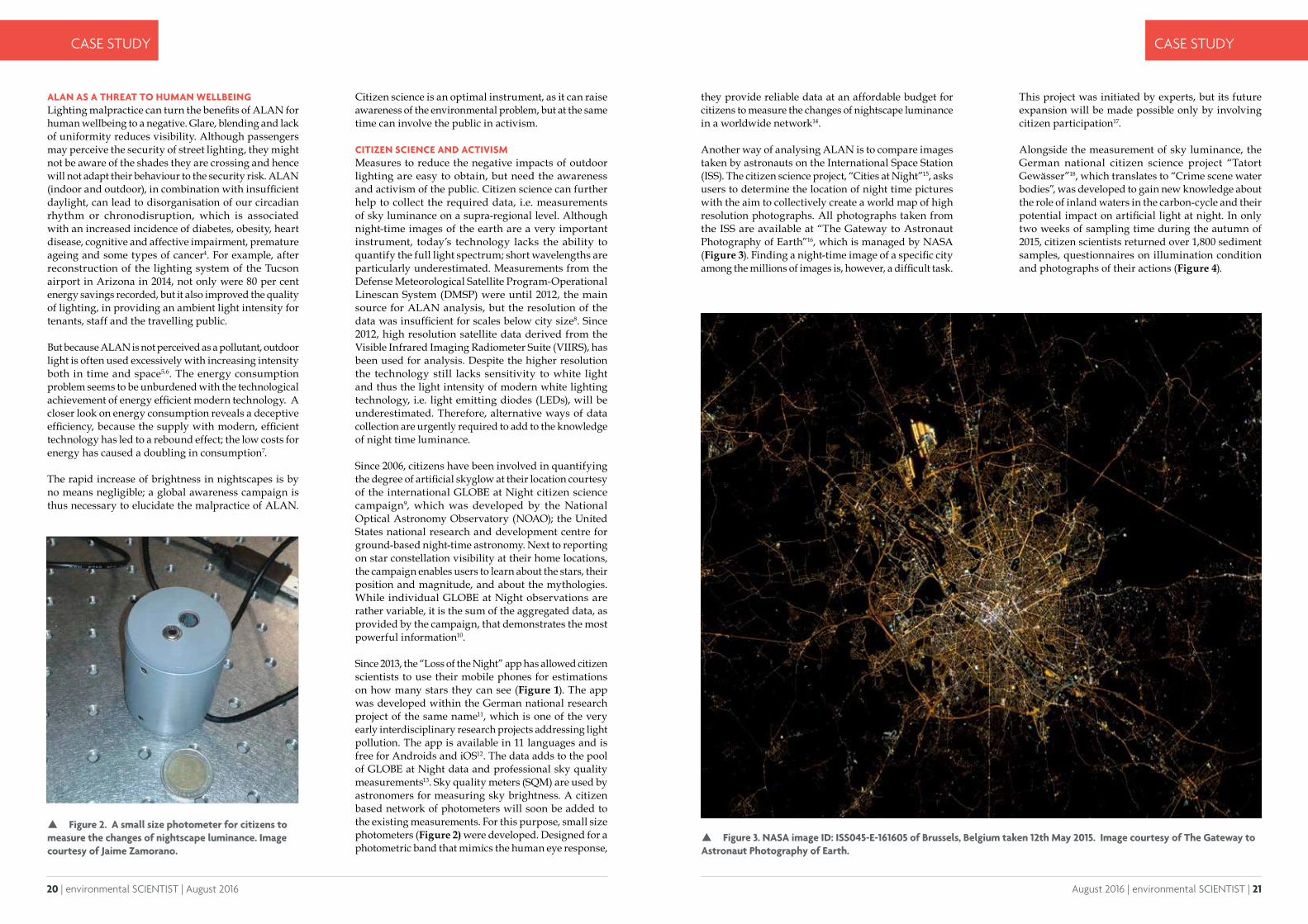
CITIZEN SCIENCE AND ACTIVISM Measures to reduce the negative impacts of outdoor lighting are easy to obtain, but need the awareness and activism of the public. Citizen science can further help to collect the required data, i.e. measurements of sky luminance on a supra-regional level. Although night-time images of the earth are a very important instrument, today’s technology lacks the ability to quantify the full light spectrum; short wavelengths are particularly underestimated. Measurements from the Defense Meteorological Satellite Program-Operational Linescan System (DMSP) were until 2012, the main source for ALAN analysis, but the resolution of the data was insufficient for scales below city size8. Since 2012, high resolution satellite data derived from the Visible Infrared Imaging Radiometer Suite (VIIRS), has been used for analysis. Despite the higher resolution the technology still lacks sensitivity to white light and thus the light intensity of modern white lighting technology, i.e. light emitting diodes (LEDs), will be underestimated. Therefore, alternative ways of data collection are urgently required to add to the knowledge of night time luminance.
Since 2006, citizens have been involved in quantifying the degree of artificial skyglow at their location courtesy of the international GLOBE at Night citizen science campaign9, which was developed by the National Optical Astronomy Observatory (NOAO); the United States national research and development centre for ground-based night-time astronomy. Next to reporting on star constellation visibility at their home locations, the campaign enables users to learn about the stars, their position and magnitude, and about the mythologies. While individual GLOBE at Night observations are rather variable, it is the sum of the aggregated data, as provided by the campaign, that demonstrates the most powerful information10.
Since 2013, the “Loss of the Night” app has allowed citizen scientists to use their mobile phones for estimations on how many stars they can see (Figure 1). The app was developed within the German national research project of the same name11, which is one of the very early interdisciplinary research projects addressing light pollution. The app is available in 11 languages and is free for Androids and iOS12. The data adds to the pool of GLOBE at Night data and professional sky quality measurements13. Sky quality meters (SQM) are used by astronomers for measuring sky brightness. A citizen based network of photometers will soon be added to the existing measurements. For this purpose, small size photometers (Figure 2) were developed. Designed for a photometric band that mimics the human eye response,
they provide reliable data at an affordable budget for citizens to measure the changes of nightscape luminance in a worldwide network14.
Another way of analysing ALAN is to compare images taken by astronauts on the International Space Station (ISS). The citizen science project, “Cities at Night”15, asks users to determine the location of night time pictures with the aim to collectively create a world map of high resolution photographs. All photographs taken from the ISS are available at “The Gateway to Astronaut Photography of Earth”16, which is managed by NASA (Figure 3). Finding a night-time image of a specific city among the millions of images is, however, a difficult task.
This project was initiated by experts, but its future expansion will be made possible only by involving citizen participation17.
Alongside the measurement of sky luminance, the German national citizen science project “Tatort Gewässer”18, which translates to “Crime scene water bodies”, was developed to gain new knowledge about the role of inland waters in the carbon-cycle and their potential impact on artificial light at night. In only two weeks of sampling time during the autumn of 2015, citizen scientists returned over 1,800 sediment samples, questionnaires on illumination condition and photographs of their actions (Figure 4).
Figure 2. A small size photometer for citizens to measure the changes of nightscape luminance. Image courtesy of Jaime Zamorano.
Figure 3. NASA image ID: ISS045-E-161605 of Brussels, Belgium taken 12th May 2015. Image courtesy of The Gateway to Astronaut Photography of Earth.
ALAN AS A THREAT TO HUMAN WELLBEINGLighting malpractice can turn the benefits of ALAN for human wellbeing to a negative. Glare, blending and lack of uniformity reduces visibility. Although passengers may perceive the security of street lighting, they might not be aware of the shades they are crossing and hence will not adapt their behaviour to the security risk. ALAN (indoor and outdoor), in combination with insufficient daylight, can lead to disorganisation of our circadian rhythm or chronodisruption, which is associated with an increased incidence of diabetes, obesity, heart disease, cognitive and affective impairment, premature ageing and some types of cancer4. For example, after reconstruction of the lighting system of the Tucson airport in Arizona in 2014, not only were 80 per cent energy savings recorded, but it also improved the quality of lighting, in providing an ambient light intensity for tenants, staff and the travelling public.
But because ALAN is not perceived as a pollutant, outdoor light is often used excessively with increasing intensity both in time and space5,6. The energy consumption problem seems to be unburdened with the technological achievement of energy efficient modern technology. A closer look on energy consumption reveals a deceptive efficiency, because the supply with modern, efficient technology has led to a rebound effect; the low costs for energy has caused a doubling in consumption7.
The rapid increase of brightness in nightscapes is by no means negligible; a global awareness campaign is thus necessary to elucidate the malpractice of ALAN.

22 | environmental SCIENTIST | August 2016 August 2016 | environmental SCIENTIST | 23
CASE STUDY CASE STUDY
The interest in citizen activities to explore nature is tremendous. More and more activities focus on light pollution. The European Commission initiated the creation of Collective Awareness Platforms for Sustainability and Social Innovation (CAPS) supported by the Horizon 2020 framework. For citizen activism to increase awareness about light pollution, the coordinators from Universidad Politécnica de Madrid and their partners, have started working on the development of a collective awareness platform for promoting dark skies, called “Stars4all”19. The public will be able to contribute to the network of data collection and mapping and will be further invited to initiate self-sustainable light pollution initiatives. The platform provides access to running activities, i.e. how to purchase low-cost photometers, or the broadcasting of astronomical phenomena, such as eclipses and Aurelia Borealis, and it will offer various tools for education, campaigning and crowdfunding.
MEASURES AGAINST LIGHT POLLUTIONAll the above mentioned initiatives aim at raising the awareness for measures against light pollution.
But what are these measures? ALAN has a purpose, for example, to illuminate a walkway, but light spill into the sky or adjacent habitats in turn becomes a pollutant. Full shielding of light sources is useful to guide the light onto target areas and avoid stray light (Figure 5). Visibility is rather a matter of contrast and light uniformity, than of light intensity. Sustainable lighting planning will use low light intensities, because any light used in too high an intensity will contribute, to a greater extent, to the accumulation of ALAN in the form of skyglow20. Low intensities, shielding of light sources and reducing the per capita number of lighting points can lower the contribution to skyglow and thus its environmental impact by up to 25 per cent21,22. Especially short wavelengths interfere with star visibility and the circadian Zeitgeber of higher vertebrates, including humans, which is the most sensitive to this part of the spectrum4,23,24. Intense cold white light can have detrimental effects on the environment and its application needs careful consideration of the costs. Warm white light with a colour temperature less than 3000 Kelvin, provides good colour rendering properties, and has less of a negative impact on the environment.
70°<70°
Figure 4. Citizen science action to discover the impact of artificial light on microbial sediment communities within the German national project “Tatort Gewässer”. The images are courtesy of a participating family.
Figure 5. Recommendations for shielding of luminaires to reduce light pollution. It is recommended to keep the beam angle below 70° so as to minimize the upward light output. For vertical illumination, reduce the spill over and around the target structure.
24 | environmental SCIENTIST | August 2016 August 2016 | environmental SCIENTIST | 25
CASE STUDY
The following five guidelines help to detect and reduce malpractices of artificial light at night25:
1. Direct the light to where it is needed;2. Reduce the light intensity to the minimum needed;3. Use light spectra adapted to the environment;4. When using white light, choose a warm colour
temperature (<3000 Kelvin);5. Limit the use of light to when it is needed.
Before and after changing a light situation, measurements are recommended to evaluate lighting design or lighting optimisation. As a collective community, we might be able to overcome the problems of light pollution, because unlike other forms of environmental pollution, light pollution is one that we can imagine solving within our lifetimes. To get involved, visit the stars4all website.19
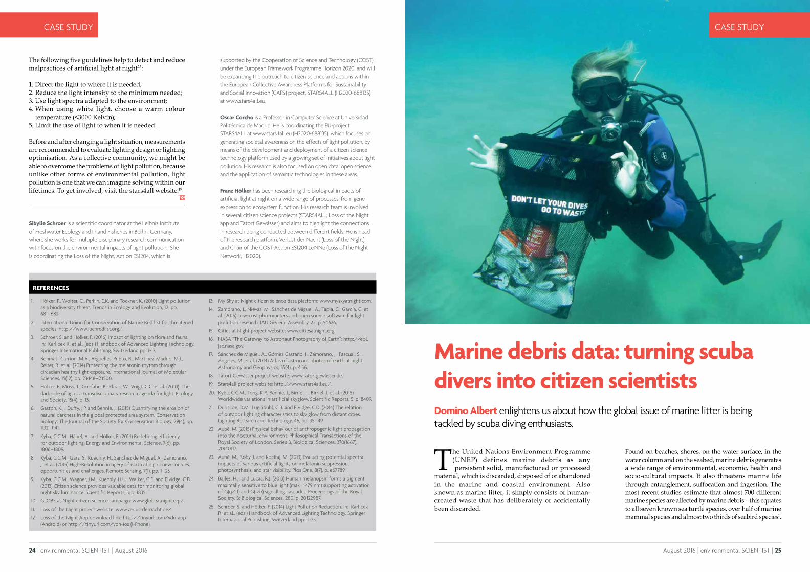
Marine debris data: turning scuba divers into citizen scientistsDomino Albert enlightens us about how the global issue of marine litter is being tackled by scuba diving enthusiasts.
The United Nations Environment Programme (UNEP) defines marine debris as any persistent solid, manufactured or processed
material, which is discarded, disposed of or abandoned in the marine and coastal environment. Also known as marine litter, it simply consists of human-created waste that has deliberately or accidentally been discarded.
Found on beaches, shores, on the water surface, in the water column and on the seabed, marine debris generates a wide range of environmental, economic, health and socio-cultural impacts. It also threatens marine life through entanglement, suffocation and ingestion. The most recent studies estimate that almost 700 different marine species are affected by marine debris – this equates to all seven known sea turtle species, over half of marine mammal species and almost two thirds of seabird species1.
supported by the Cooperation of Science and Technology (COST) under the European Framework Programme Horizon 2020, and will be expanding the outreach to citizen science and actions within the European Collective Awareness Platforms for Sustainability and Social Innovation (CAPS) project, STARS4ALL (H2020-688135) at www.stars4all.eu.
Oscar Corcho is a Professor in Computer Science at Universidad Politécnica de Madrid. He is coordinating the EU-project STARS4ALL at www.stars4all.eu (H2020-688135), which focuses on generating societal awareness on the effects of light pollution, by means of the development and deployment of a citizen science technology platform used by a growing set of initiatives about light pollution. His research is also focused on open data, open science and the application of semantic technologies in these areas.
Franz Hölker has been researching the biological impacts of artificial light at night on a wide range of processes, from gene expression to ecosystem function. His research team is involved in several citizen science projects (STARS4ALL, Loss of the Night app and Tatort Gewässer) and aims to highlight the connections in research being conducted between different fields. He is head of the research platform, Verlust der Nacht (Loss of the Night), and Chair of the COST-Action ES1204 LoNNe (Loss of the Night Network, H2020).
CASE STUDY
REFERENCES
1. Hölker, F., Wolter, C., Perkin, E.K. and Tockner, K. (2010) Light pollution as a biodiversity threat. Trends in Ecology and Evolution, 12, pp. 681–682.
2. International Union for Conservation of Nature Red list for threatened species: http://www.iucnredlist.org/.
3. Schroer, S. and Hölker, F. (2016) Impact of lighting on flora and fauna. In: Karlicek R. et al., (eds.) Handbook of Advanced Lighting Technology. Springer International Publishing, Switzerland pp. 1-17.
4. Bonmati-Carrion, M.A., Arguelles-Prieto, R., Martinez-Madrid, M.J., Reiter, R. et al. (2014) Protecting the melatonin rhythm through circadian healthy light exposure. International Journal of Molecular Sciences, 15(12), pp. 23448–23500.
5. Hölker, F., Moss, T., Griefahn, B., Kloas, W., Voigt, C.C. et al. (2010). The dark side of light: a transdisciplinary research agenda for light. Ecology and Society, 15(4), p. 13.
6. Gaston, K.J., Duffy, J.P. and Bennie, J. (2015) Quantifying the erosion of natural darkness in the global protected area system. Conservation Biology: The Journal of the Society for Conservation Biology, 29(4), pp. 1132–1141.
7. Kyba, C.C.M., Hänel, A. and Hölker, F. (2014) Redefining efficiency for outdoor lighting. Energy and Environmental Science, 7(6), pp. 1806–1809.
8. Kyba, C.C.M., Garz, S., Kuechly, H., Sanchez de Miguel, A., Zamorano, J. et al. (2015) High-Resolution imagery of earth at night: new sources, opportunities and challenges. Remote Sensing, 7(1), pp. 1–23.
9. Kyba, C.C.M., Wagner, J.M., Kuechly, H.U., Walker, C.E. and Elvidge, C.D. (2013) Citizen science provides valuable data for monitoring global night sky luminance. Scientific Reports, 3, p. 1835.
10. GLOBE at Night citizen science campaign: www.globeatnight.org/.
11. Loss of the Night project website: www.verlustdernacht.de/.
12. Loss of the Night App download link: http://tinyurl.com/vdn-app (Android) or http://tinyurl.com/vdn-ios (I-Phone).
13. My Sky at Night citizen science data platform: www.myskyatnight.com.
14. Zamorano, J., Nievas, M., Sánchez de Miguel, A., Tapia, C., García, C. et al. (2015) Low-cost photometers and open source software for light pollution research. IAU General Assembly, 22, p. 54626.
15. Cities at Night project website: www.citiesatnight.org.
16. NASA “The Gateway to Astronaut Photography of Earth”: http://eol.jsc.nasa.gov.
17. Sánchez de Miguel, A., Gómez Castaño, J., Zamorano, J., Pascual, S., Ángeles, M. et al. (2014) Atlas of astronaut photos of earth at night. Astronomy and Geophysics, 55(4), p. 4.36.
18. Tatort Gewässer project website: www.tatortgewässer.de.
19. Stars4all project website: http://www.stars4all.eu/.
20. Kyba, C.C.M., Tong, K.P., Bennie, J., Birriel, I., Birriel, J. et al. (2015) Worldwide variations in artificial skyglow. Scientific Reports, 5, p. 8409.
21. Duriscoe, D.M., Luginbuhl, C.B. and Elvidge, C.D. (2014) The relation of outdoor lighting characteristics to sky glow from distant cities. Lighting Research and Technology, 46, pp. 35–49.
22. Aubé, M. (2015) Physical behaviour of anthropogenic light propagation into the nocturnal environment. Philosophical Transactions of the Royal Society of London. Series B, Biological Sciences, 370(1667), 20140117.
23. Aubé, M., Roby, J. and Kocifaj, M. (2013) Evaluating potential spectral impacts of various artificial lights on melatonin suppression, photosynthesis, and star visibility. Plos One, 8(7), p. e67789.
24. Bailes, H.J. and Lucas, R.J. (2013) Human melanopsin forms a pigment maximally sensitive to blue light (max ≈ 479 nm) supporting activation of G(q/11) and G(i/o) signalling cascades. Proceedings of the Royal Society. B: Biological Sciences, 280, p. 20122987.
25. Schroer, S. and Hölker, F. (2014) Light Pollution Reduction. In: Karlicek R. et al., (eds.) Handbook of Advanced Lighting Technology. Springer International Publishing, Switzerland pp. 1-33.
Sibylle Schroer is a scientific coordinator at the Leibniz Institute of Freshwater Ecology and Inland Fisheries in Berlin, Germany, where she works for multiple disciplinary research communication with focus on the environmental impacts of light pollution. She is coordinating the Loss of the Night, Action ES1204, which is

26 | environmental SCIENTIST | August 2016 August 2016 | environmental SCIENTIST | 27
CASE STUDY CASE STUDY
SOURCES OF MARINE DEBRISWhere does marine debris come from? There are many different sources which can be broadly categorised into sea-based sources and land-based sources. Although most marine debris makes its way to the ocean via land-based sources such as public littering, storm water discharges and untreated sewage to name but a few, sea-based sources also play a part including debris lost or purposefully dumped at sea from boats and ships, oil and gas rigs as well as aquaculture farms. Whether marine debris makes its way into the ocean from land or sea-based sources, one thing is certain – it is the result of our unsustainable production and consumption patterns and mismanagement of our waste.
PROJECT AWARE® AND DIVE AGAINST DEBRISTM
Recognising the power of the diving community as citizen scientists, Project AWARE 2, a global marine conservation non-profit organisation, has developed “Dive Against Debris” the world’s first and only underwater marine debris survey and removal programme that operates on a global scale. However, it has another role in which it yields data on the types and quantities of marine debris found on the seabed. This is because, not only do divers have a natural affinity to protect the marine environment, they have the unique skill set to take direct action whilst underwater to protect marine wildlife from the devastating impacts of marine debris.
Once reported, the data undergoes a quality assurance process to ensure accuracy and integrity before being added to a global database, and visualised on Project AWARE’s innovative and interactive Dive Against Debris’ Map3. All land data is removed and any data inconsistencies are clarified with the survey leader and corrected. This is what makes Dive Against Debris so unique – it’s the only programme of its kind to focus exclusively on providing an accurate and quantitative perspective of waste found underwater.
Anyone can conduct a Dive Against Debris survey as long as he or she is a certified scuba diver. But to further support the programme, and to equip divers with
greater skills and knowledge necessary to independently conduct their own survey, report data accurately and become a true debris activist, Project AWARE has launched a Dive Against Debris Distinctive Specialty Course which is available in 12 different languages. With the help of a Marine Debris Identification Guide4, a specialised data card5 and other translated tools and resources, thousands of scuba divers have been trained on how to report their findings to Project AWARE. Divers and non-divers alike can view the results of these surveys and see their efforts combined with others to reveal the underwater and global perspective of marine debris. Map users can zoom and click to view individual surveys from around the world, and filter by different debris types and time periods. They can also see underwater photographs, which allow the viewer to gain an understanding of the impact that everyday waste is having on marine wildlife and fragile ecosystems.
LONG TERM AMBITIONSDive Against Debris surveys not only provide an immediate relief to undersea habitats and marine life through the direct actions of participating dive volunteers, the data contributes to long-term solutions by building the evidence necessary to advocate for change. Comparatively speaking, information regarding land debris is widely available, but there has been a void in information regarding underwater marine debris. Dive Against Debris aims to fill this gap by providing quantitative data to show the true extent of the global marine debris crisis. The data yielded bridges the gap to an issue that has been previously disregarded as “Out of sight and out of mind”. By sharing the data with partners and making it available for all to see online through the Dive Against Debris interactive online map, Project AWARE and its dedicated army of debris activists and citizen scientists, are working with partners to find solutions that will ultimately prevent debris entering the ocean in the first place.
Whilst a considerable amount of data has been compiled through Dive Against Debris surveys to date, Project AWARE hopes that more divers will get involved and “Will put their scuba skills to good use”. To further encourage participation in Dive Against Debris and further empower dive leaders and dive businesses to take ownership of the dive sites they frequent on a regular basis, and create a network of “Ocean Stewards”, Project AWARE has launched “Adopt a Dive Site™”. This new initiative engages dive centres, resorts and dive leaders to commit to ongoing, local protection of dive sites around the globe. By conducting repeat monthly Dive Against Debris surveys at individual dive site locations, participants will help advance ocean conservation with direct citizen science action. Participating dive centres and resorts will be provided with a full suite of new tools to help implement their actions, a yearly report on the state of their local dive sites and recognition tools
© Richard Carey | Fotolia
28 | environmental SCIENTIST | August 2016 August 2016 | environmental SCIENTIST | 29
CASE STUDY CASE STUDY
to share their stewardship with their local community. Adopt a Dive Site will assist in increasing the public’s participation in Dive Against Debris, to ultimately help identify target areas where waste reduction efforts are needed most.
Information collected by scuba divers provides a unique underwater view into the growing problem of ocean waste. The Dive Against Debris interactive online map visualises more than five years of ongoing reporting by a network of scuba divers who remove marine debris from the world’s ocean. The map is a digital showcase of the grass root work its volunteers are doing to protect the ocean from the onslaught of marine debris. Project AWARE’s latest initiative, Adopt a Dive SiteTM, aims at bridging a scientific data gap in debris specifically found on the seabed, by mobilising a new wave of ocean stewards to conduct repeat surveys in order to build repeat data for individual dive sites. Project AWARE citizen scientists are mobilising to influence change, and fight back against one of the deadliest by products of our growing consumer society: marine debris.
RESULTS TO DATESince the inception of Dive Against Debris in 2011, more than 20,000 divers have conducted over 2,500 surveys, reporting and removing over 600,000 waste items from the sea floor. Data collected so far consistently shows
Domino Albert developed a passion for the underwater world and ocean conservation in the mid-1990s teaching scuba diving. Now Communications Manager at Project AWARE, Domino drives the non-profit global communication strategy and spread the word about the threats facing our ocean. emphasizing how divers can make positive lasting environmental changes. Domino has more than 15 years of experience in the non-profit sector, fundraising, leading communications and engagement campaigns, and managing organizational strategy and operations.
REFERENCES
1. Gall, S. and Thompson, R. (2015) The impact of debris on marine life. Marine Pollution Bulletin, 92 (1–2), pp. 170-179.
2. Project Aware, http://www.projectaware.org.
3. Dive Against Debris™ Map, http://www.projectaware.org/diveagainstdebrismap.
4. Dive Against Debris™ Marine Debris Identification Guide, revised 09/2015, http://www.projectaware.org/resource/dive-against-debris-survey-kit.
5. Dive Against Debris™ Data Card, revised 09/2015, http://www.projectaware.org/resource/dive-against-debris-survey-kit.
6. Project Aware, The Ugly Journey of Our Trash, http://www.projectaware.org/project/ugly-journey-our-trash.
that the majority of items removed and reported by scuba divers is plastic.
Project AWARE Program Specialist Hannah Pragnell-Raasch comments:
“With 150 million metric tons of mismanaged plastic conservatively estimated to make its way into the ocean by 2025, it sadly comes as no surprise that plastic items are consistently the top items reported – accounting for almost 70% of all debris items reported to date. That’s really quite staggering and serves as a harsh reminder that we, the human population, really are choking our marine environment”.
“ 150 million metric tons of mismanaged plastic conservatively estimated to make its way into the ocean by 2025”
So far this year, over 3,000 scuba divers have taken part in more than 400 Dive Against Debris surveys across
the globe – spending almost 400 hours underwater surveying dive sites. Malaysia, the United States of America and Thailand are thus far, the top reporting countries. Sadly, over 700 species have been reported so far this year, entangled in marine debris.
FUTURE ROLE OF PROJECT AWAREMarine debris is a complex problem – with both local and global effects. The solutions are equally complex and are not possible without partnerships and a groundswell of support for change. Project AWARE is committed to developing solutions through partnerships with individuals, governments, non-governmental organisations and businesses. The unique underwater perspective that divers have on the marine debris issue also helps shape the understanding of these groups.
Marine litter is one of the clearest symbols of a resource inefficient economy. Through Project AWARE’s partnerships against waste, this non-profit organisation is working towards a much-needed transition from a linear “take, make, dispose” model of economic growth to a circular economy where products are designed to be reused and recycled continuously. Scuba divers conducting Dive Against Debris surveys are helping Project AWARE work towards long-term effective solutions to end this ugly journey of our trash6.
© underwaterstas | Adobe Stock
30 | environmental SCIENTIST | August 2016 August 2016 | environmental SCIENTIST | 31
ANALYSIS ANALYSIS
New members and re-grades Maximilian Smeeth – Environmental Scientist
Adam Sokolowski – Associate Director
Jenny Spencer – Senior Environmental Scientist
Gilbert Stevenson – Head of Development UK
Emily Sullivan – Air Quality Consultant
Philip Sutton – Founder and Technical Director
Catherine Tame – Senior Environmental Consultant
Vincent Tanyanyiwa – Senior Lecturer
Christopher Taylor – Associate Director
Charlotte Taylor – Senior Environmental Scientist
Philip Thompson – Senior Consultant
Jeffrey Turner – Environmental Associate
George Vergoulas – Sustainability Consultant / Carbon
Rosie Vetter – Project Development Manager
Sarah Waterhouse – Associate
Simon Wheeler – Head of Planning
Christopher Willans – Assistant Air Quality Specialist
Ruth Willcox – Civil Protection Officer
Daniel Williams – Environmental Consultant
Katie Wilson – Remediation Engineer/Project Manager
James Wilson – Associate, Remediation Specialist
Zhiyuan Yang – Principal Environmental Consultant
Rosemary Adamson – Graduate
Jane Baird – Geo-Environmental Consultant
Kathryn Barker – Assistant Air Quality Consultant
Lydia Beaman – Policy Officer
Jonas Beaugas – Consultant
Gordon Campbell – Technical Assistant in Respiratory Physiology
Gary Chapman – Environmental Scientist (Main Grade)
Maria Ciobanu – Graduate
Jordan Clarke – Senior GIS Technician
Sarah Clinton – Air Quality Consultant
James Collins – Environmental Consultant
Beth Coombs – Student Assistant
Matthew Cox – Graduate Scientist/AQ Consultant
Grant de Garis – Consultant Engineer
Philippa Douglas – Research Associate in Environmental Health
Abiola Fadiora – Graduate Environmentalist Consultant
Luke Farrugia – Air Quality Specialist
Dominic Flynn – Environmental Specialist
Rebeckah Fox – Graduate
Gregory Gibson – Graduate Geo-Environmental Consultant
Robert Gloyns – Air Quality Intern
Matthew Greasby – Graduate
Andrew Green – Envrionmental Scientist
Ronan Handcock – Assistant Consultant
Daniel Harris – Graduate Environmental Scientist
Michael Haydock – Environmental Consultant
Hannah Hodson – Technical Officer
Tomos Sioni Hole – Graduate Air Quality Consultant
David Howells – Graduate Air Quality Consultant
Jack Hunter – Senior Geo-Environmental Engineer
Satbir Jandu – Graduate Air Quality Consultant
Michael Joshua – Graduate
Charmaine Jude – Business Support Officer
Blaise Kelly – Building Performance Engineer
Roulin Khondoker – Research Fellow
Rebecca Long – Consultant
Rachel Metcalfe – Graduate
Amy Nichol – Graduate Environmental Scientist
Victoria O'Brien – Graduate Flood Risk Specialist
Aine O'Shea – Environmental Scientist
Adam Palmer – Health Physicist
Leanne Parrott – Research Engineer - Fuel Cell and Stack Engineer II
Niloofar Pirmohammadi – Accounts Assistant
John Powell – Departmental Administrator
Giancarlo Quaroni Guest Support Manager
Kristopher Rodway – Geo-Environmental Engineer
William Smith – Assistant Consultant (Air Quality)
Mark Speed – Acoustic Consultant
Luke Stock – Consultant Engineer
Nicola Swallow – Graduate Geo-Environmental Consultant
Selina Talukdar – Project Officer
Ashleigh Thorneycroft – Graduate
Colin Tully – Graduate Environmental Consultant
Lucy Turner – Graduate
Hannah Walton – Graduate Environmental Consultant
Michael Whittall – Graduate Environmental Engineer
Charlotte Williamson – Environmental and Business Continuity Executive
Mirella Bremner – Student & Legal Secretary
Allison Cartwright – Student
Michael Cuff – Student
Gethin Davey – Dog Handler
Elizabeth Hadland – Chartered Physio & Student
Carly Hoyle – Asbestos Consultant
Alison Rogers – Key Account Manager
Daniel Wilkinson – Contract Attorney
Edmund Wooldridge – Student
Paul Ciniglio - Sustainability Strategist
Samaila Ammani – Director Strategy
William Anstey – Associate Consultant
Ifeyinwa Arinze – Geo-Enviromental Engineer
Phillip Aspden – Senior Consultant
Sunny Bagga – Programme Leader Health and Life Sciences
Joanna Barnes – Research Associate
Philip Battye – Operations Director and Deputy M.D.
Richard Biney – Principal Geo-Environmental Engineer
Elizabeth Bohun – Environmental Sustainability Projects Officer
Sam Bulmer – Assistant Environmental Consultant
Rory Carmichael – Senior Environmental Consultant
Daniel Carpenter – Projects Manager
Nicola Catt – Senior Environmental Consultant
Paul Cawsey – Sustainability Manager
Andrew Channing – Project Support (Engineering)
Chibuike Chigbo – Lecturer/Project Supervisor
Catherine Cooke – Director - Head of Geo-Environmental (South)
Graham Cowden – Environmental Advisor/Engineer
Andrea Crump – Sustainability Manager
Paul Curtis – Senior Process Engineer
Mark Davies – Senior Environmental Consultant
Andrew Donohoe – Environmental Scientist
Claire Duncan – Geo-Environmental Engineer
Robert Edwards – Head of Environmental Assessment
David Edwards – Associate Lecturer
Melinda Evans – Environmental Engineer
Ruth FitzGerald – Waste Strategy Manager
David Fountain – Pollution Officer (Contaminated Land)
Andrew Fowler – Environmental Consultant
Stewart Friel – Director
Jonathan Friend-Thomas – Senior Environmental Consultant
Andrew Galligan – Projects Officer
Helen Gardiner – Senior Engineer
Carol Getting – Senior Environmental Officer
Duncan Grew – Environmental Consultant
Andrew Gwatkin – Project Engineer
Matthew Hill – Assistant Air Quality Consultant
Julie Hill – Non-Executive Director & Environmental Policy Specialist
Lucy Hodgins – Air Quality Consultant
Lucy Howell – Geoenvironmental Engineer
Gareth Jenkins – Geo-environmental Consultant
Ying Jiang – Research Fellow - Phytoremediation & Energy Recovery
Maria-Eleni Karyampa – Senior Environmental Scientist
Sara Kazemi Yazdi – Assistant Professor
Tomos Kidd – Senior Environmental Consultant
George Lartey-Young – Environmental Scientist
Ting Hin Jason Lau – Chief Consultant
John Logan – Regional Sustainability Manager
Frank Macfarlane – Senior Environmental Scientist
Ross McKean – Environmental Loss Adjuster
Craig McMillan – Senior Environmental Consultant
Sarah McMonagle – Principal Consultant (Environmental and Planning)
Gemma Middleton – Environmental Consultant
Samuel Minett-Smith – Environmental Specialist
Lynda Moran – Environmental Scientist Office Manager
Craig Morris – Pollution Officer (Air Quality)
Victoria Morten – Principal
Alexander Newton – Senior Environmental Project Manager
Aimee Nicholson – Renewable Engineer
Simon Nugent – Geo-Environmental Consultant
Gareth O'Brien – Senior Environmental Consultant
Harry Parker – Senior Environmental Consultant
Ana Pestana – Associate Environmental Consultant
Sureiya Pochee – Environmental Specialist
Elizabeth Price – Head of School, Science and the Environment
Samantha Price – Associate Environmental Consultant
Jemma Prydderch – Principal Environmental Scientist
Honorata Puciato – Air Quality Consultant
James Roorda – Consultant
Jessica Salder – Principal Environmental Assessment Officer
Joining the IES helps your professional development. Whatever stage of your career you are at, the IES has membership services that will help you gain recognition and progress to the next level. Members come from all areas of the environmental sector, wherever jobs are underpinned by science.Not a member? Time for a
re-grade?Eligible for chartership?
If your career has progressed recently it could be time for a re-grade to reflect your success.
Re-grading from one level of membership to another can take place at any time of the year. Re-grading from Associate to Member means that you can apply for Chartered Environmentalist and Chartered Scientist. There’s never been a better time to take the next step in your career.
If you have been building your career for 4 years or more, now could be the right time to become Chartered.
Chartered status is a benchmark of professionalism and achieving this will see you join the ranks of the best environmental scientists in the sector.
Contact us:To find out more about membership or chartership, get in touch.
Email: [email protected] Tel: +44 (0)20 7601 1920
Web: www.the-ies.org
is for individuals with an interest in environmental issues but don't work in the field, or for students on non-accredited programs
is for esteemed individuals in environmental science and sustainability who are held in high regard by their peers
is for individuals beginning their environmental career or those working on the periphery of environmental science.
is for those individuals who have substantial academic and work experience within environmental science.
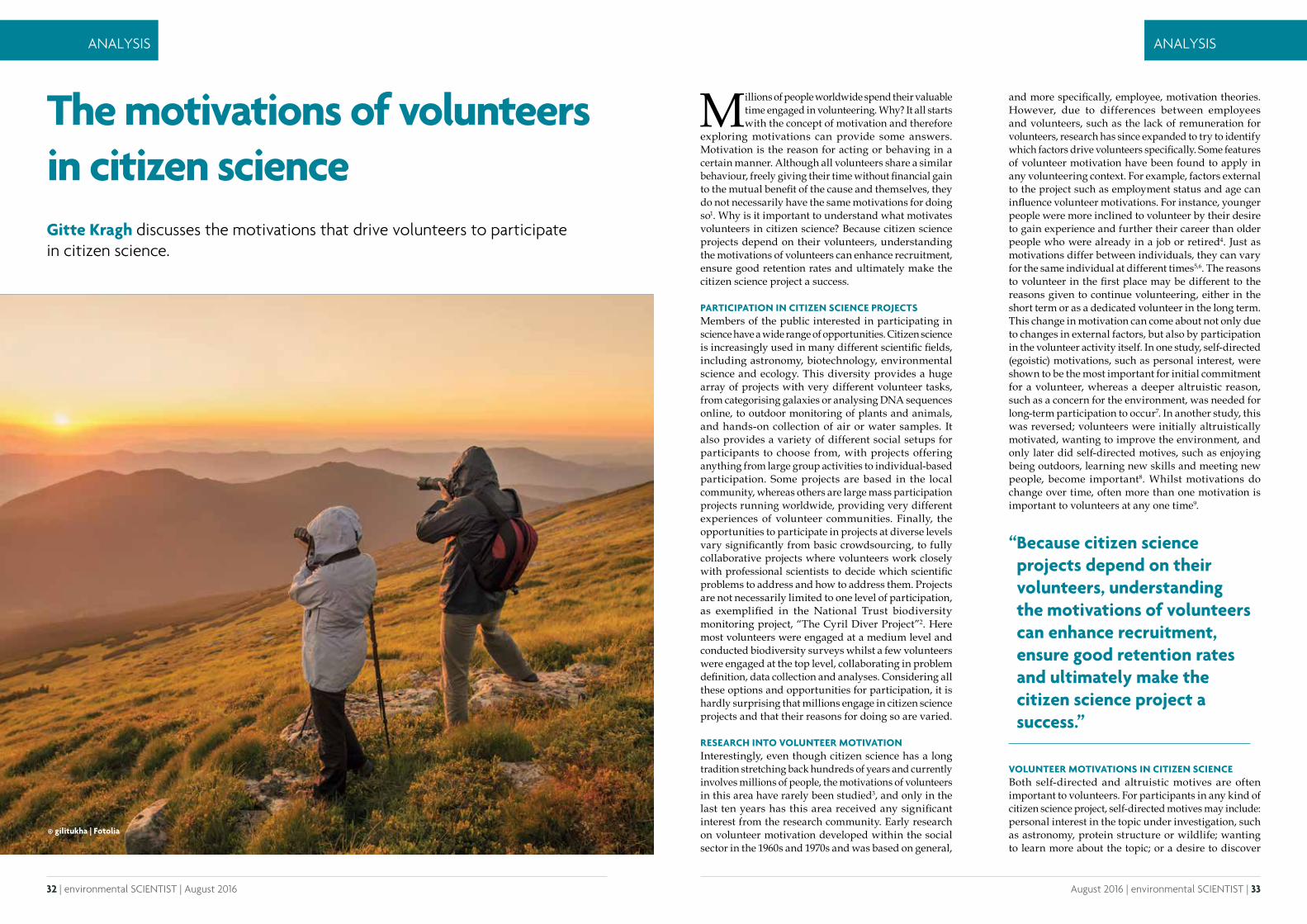
32 | environmental SCIENTIST | August 2016 August 2016 | environmental SCIENTIST | 33
ANALYSIS ANALYSIS
Millions of people worldwide spend their valuable time engaged in volunteering. Why? It all starts with the concept of motivation and therefore
exploring motivations can provide some answers. Motivation is the reason for acting or behaving in a certain manner. Although all volunteers share a similar behaviour, freely giving their time without financial gain to the mutual benefit of the cause and themselves, they do not necessarily have the same motivations for doing so1. Why is it important to understand what motivates volunteers in citizen science? Because citizen science projects depend on their volunteers, understanding the motivations of volunteers can enhance recruitment, ensure good retention rates and ultimately make the citizen science project a success.
PARTICIPATION IN CITIZEN SCIENCE PROJECTSMembers of the public interested in participating in science have a wide range of opportunities. Citizen science is increasingly used in many different scientific fields, including astronomy, biotechnology, environmental science and ecology. This diversity provides a huge array of projects with very different volunteer tasks, from categorising galaxies or analysing DNA sequences online, to outdoor monitoring of plants and animals, and hands-on collection of air or water samples. It also provides a variety of different social setups for participants to choose from, with projects offering anything from large group activities to individual-based participation. Some projects are based in the local community, whereas others are large mass participation projects running worldwide, providing very different experiences of volunteer communities. Finally, the opportunities to participate in projects at diverse levels vary significantly from basic crowdsourcing, to fully collaborative projects where volunteers work closely with professional scientists to decide which scientific problems to address and how to address them. Projects are not necessarily limited to one level of participation, as exemplified in the National Trust biodiversity monitoring project, “The Cyril Diver Project”2. Here most volunteers were engaged at a medium level and conducted biodiversity surveys whilst a few volunteers were engaged at the top level, collaborating in problem definition, data collection and analyses. Considering all these options and opportunities for participation, it is hardly surprising that millions engage in citizen science projects and that their reasons for doing so are varied.
RESEARCH INTO VOLUNTEER MOTIVATION Interestingly, even though citizen science has a long tradition stretching back hundreds of years and currently involves millions of people, the motivations of volunteers in this area have rarely been studied3, and only in the last ten years has this area received any significant interest from the research community. Early research on volunteer motivation developed within the social sector in the 1960s and 1970s and was based on general,
and more specifically, employee, motivation theories. However, due to differences between employees and volunteers, such as the lack of remuneration for volunteers, research has since expanded to try to identify which factors drive volunteers specifically. Some features of volunteer motivation have been found to apply in any volunteering context. For example, factors external to the project such as employment status and age can influence volunteer motivations. For instance, younger people were more inclined to volunteer by their desire to gain experience and further their career than older people who were already in a job or retired4. Just as motivations differ between individuals, they can vary for the same individual at different times5,6. The reasons to volunteer in the first place may be different to the reasons given to continue volunteering, either in the short term or as a dedicated volunteer in the long term. This change in motivation can come about not only due to changes in external factors, but also by participation in the volunteer activity itself. In one study, self-directed (egoistic) motivations, such as personal interest, were shown to be the most important for initial commitment for a volunteer, whereas a deeper altruistic reason, such as a concern for the environment, was needed for long-term participation to occur7. In another study, this was reversed; volunteers were initially altruistically motivated, wanting to improve the environment, and only later did self-directed motives, such as enjoying being outdoors, learning new skills and meeting new people, become important8. Whilst motivations do change over time, often more than one motivation is important to volunteers at any one time9.
VOLUNTEER MOTIVATIONS IN CITIZEN SCIENCEBoth self-directed and altruistic motives are often important to volunteers. For participants in any kind of citizen science project, self-directed motives may include: personal interest in the topic under investigation, such as astronomy, protein structure or wildlife; wanting to learn more about the topic; or a desire to discover
© gilitukha | Fotolia
The motivations of volunteers in citizen scienceGitte Kragh discusses the motivations that drive volunteers to participate in citizen science.
“ Because citizen science projects depend on their volunteers, understanding the motivations of volunteers can enhance recruitment, ensure good retention rates and ultimately make the citizen science project a success.”

34 | environmental SCIENTIST | August 2016 August 2016 | environmental SCIENTIST | 35
ANALYSIS ANALYSIS
something new, such as gaining access to new places, species or discovering new galaxies (see Table 1 for details). Depending on the type of citizen science project and form of participation, other self-directed motives may be present. For example, volunteering provides an opportunity for recreation and spending time in nature for participants in environmental projects, whereas, social motives are not rated as highly. One potential reason for the relatively low importance rating could be that participation in many projects is carried out alone, whether in online projects or environmental monitoring. This individualistic setup of project participation could deter potential participants who are looking to meet like-minded people and to join a community. To counter this, many projects have set up online forums and use social media to create virtual volunteer communities to provide opportunities for volunteers to meet each other, discuss findings and get support from their project leaders, if needed. Career motives, such as volunteering to gain experience for their CV or to “get a foot in the door” at a desired place to work, are often not mentioned in citizen science research. When career motives were mentioned, it was in the responses from students or young people7,10. Many volunteers in citizen science projects are older (40-60 years old) or retired11,12, and have no need to gain experience or contacts to further their careers. It is now generally accepted that most volunteers have some self-directed reasons for volunteering; however, altruistic motives are often more important than self-directed motives.
An important altruistic motive for participants in many different citizen science projects is their wish to contribute to science, a drive that is unique to citizen science and sets it apart from other volunteering opportunities. Other altruistic motives, such as volunteering for a cause or feeling it is important to help, are significant for many as well. Participants in environmental citizen science projects, like biodiversity monitoring, are often altruistically motivated because they are concerned about the environment and feel it is important to help conservation efforts.
MEETING VOLUNTEERS’ MOTIVATIONS After understanding volunteers’ motivations, the next step for citizen science projects is to meet these to ensure a high level of satisfaction and thus retention. If volunteers continue for longer, they will understand their tasks better and may therefore be able to perform to a higher standard. This can save resources because of a lower need for additional recruitment and training of new recruits6, and it ultimately contributes to better outcomes for organisations and the causes they work for. If primary motivations are perceived by volunteers to be met, they become more satisfied4,20 and they tend to keep volunteering for longer1,21. However, a recent study has shown that not all motivations are equal in relation to achieving volunteer satisfaction: altruistic
motives were positively correlated with satisfaction and intention to continue volunteering, whereas self-directed motives were negatively correlated with satisfaction and intention to continue22. Meeting altruistic motivations of volunteers is therefore key to retaining volunteers. This means projects need to ensure sufficient and prompt feedback to volunteers on how their data contribute to science and therefore to their chosen cause.
With the current explosion in numbers and types of citizen science projects, there may be increased competition for volunteers in the future. As we learn more about why people volunteer with different citizen science projects and how motivations can be satisfied, this knowledge can be incorporated into volunteer management strategies that will attract and satisfy volunteers; the end result is that retention will be greater and volunteers will spread the word and encourage others to participate and ultimately help the project succeed.
AcknowledgementsI am grateful to Hayley Roberts, Chris Shiel, Susanna Curtin and Rick Stafford at Bournemouth University for their helpful discussions and comments on the manuscript.
Gitte Kragh has managed volunteers in ecological projects around the world and volunteered extensively herself for the past 20 years. She is currently finishing a PhD at Bournemouth University where she is researching how conservation outcomes and volunteers’ wellbeing are linked and can be optimised by understanding and meeting volunteer motivations in ecological projects. ([email protected])
REFERENCES
1. Clary, E. G., Snyder, M., Ridge, R. D., Copeland, J., Stukas, A. A., Haugen, J. and Miene, P. (1998) Understanding and assessing the motivations of volunteers: A functional approach. Journal of Personality and Social Psychology, 74 (6), pp. 1516–1530.
2. National Trust, The Cyril Diver Project, https://www.nationaltrust.org.uk/studland-beach/features/the-cyril-diver-project.
3. Nov, O., Arazy, O. and Anderson, D. (2014) Scientists@Home: what drives the quantity and quality of online citizen science participation? PloS one, 9 (4), p. e90375.
4. Musick, M. A. and Wilson, J. (2008) Volunteers: a social profile Indiana. University Press, Bloomington.
5. Ryan, R. L., Kaplan, R. and Grese, R. E. (2001) Predicting Volunteer Commitment in Environmental Stewardship Programmes. Journal of Environmental Planning and Management, 44 (5), pp. 629–648.
6. Clary, E. G., Snyder, M. and Ridge, R. (1992) Volunteers’ motivations: a functional strategy for the recruitment, placement, and retention of volunteers. Non-profit management and leadership, 2 (4), pp. 333–350.
7. Rotman, D., Hammock, J., Preece, J., Hansen, D., Boston, C., Bowser, A. and He, Y. (2014) Motivations affecting initial and long-term participation in citizen science projects in three countries. iConference 2014 Proceedings, pp. 110–124.
8. The Conservation Volunteers (2014) Volunteering Impacts. The Conservation Volunteers, Doncaster.
9. Bell, S., Marzano, M., Reinert, H., Cent, J., Kobierska, H., Grodzi ska-Jurczak, M., Podjed, D., Muršič, R., Vandzinskaite, D. and Armaitiene, A. (2008) What counts? Volunteers and their organisations in the recording and monitoring of biodiversity. Biodiversity and Conservation, 17 (14), pp. 3443–3454.
10. Johnson, M. F., Hannah, C., Acton, L., Popovici, R., Karanth, K. K. and Weinthal, E. (2014) Network environmentalism: Citizen scientists as agents for environmental advocacy. Global Environmental Change, 29, pp. 235–245.
11. Raddick, M. J., Bracey, G., Gay, P. L., Lintott, C. J., Cardamone, C., Murray, P., Schawinski, K., Szalay, A. S. and Vandenberg, J. (2013) Galaxy Zoo: Motivations of Citizen Scientists. Astronomy Education Review, 12 (1), pp. 1–27.
12. Wright, D. R., Underhill, L. G., Keene, M., and Knight, A. T. (2015) Understanding the Motivations and Satisfactions of Volunteers to Improve the Effectiveness of Citizen Science Programs. Society & Natural Resources, 28 (9), pp. 1013–1029.
13. Weston, M., Fendley, M., Jewell, R., Satchell, M. and Tzaros, C. (2003) Volunteers in bird conservation: Insights from the Australian Threatened Bird Network. Ecological Management and Restoration, 4 (3), pp. 205–211.
14. Davies, L., Bell, J. N. B., Bone, J., Head, M., Hill, L., Howard, C., Hobbs, S. J., Jones, D. T., Power, S. A., Rose, N., Ryder, C., Seed, L., Stevens, G., Toumi, R., Voulvoulis, N. and White, P. C. L. (2011) Open Air Laboratories (OPAL): A community-driven research programme. Environmental Pollution, 159 (8-9), pp. 2203–2210.
15. Hobbs, S. J. and White, P. C. L. (2012) Motivations and barriers in relation to community participation in biodiversity recording. Journal for Nature Conservation, 20 (6), pp. 364–373.
16. Curtis, V. (2015) Motivation to Participate in an Online Citizen Science Game: A Study of Foldit. Science Communication, 37(6), pp. 723-746.
17. Thiel, M., Penna-Diaz, M. A., Luna-Jorquera, G., Salas, S., Sellanes, J. and Stotz, W. (2014) Citizen scientists and marine research: volunteer participants, their contributions, and projection for the future. Oceanography and Marine Biology: An Annual Review, 52, pp. 257–314.
18. Raddick, M. J., Bracey, G., Gay, P. L., Lintott, C. J., Murray, P., Schawinski, K., Szalay, A. S. and Vandenberg, J. (2010) Galaxy Zoo: Exploring the Motivations of Citizen Science Volunteers. Astronomy Education Review, 9 (1), pp. 10103–10118.
19. Krebs, V. (2010) Motivations of cybervolunteers in an applied distributed computing environment: MalariaControl.net as an example. First Monday. http://firstmonday.org/htbin/cgiwrap/bin/ojs/index.php/fm/article/viewArticle/2783.
20. Finkelstein, M. A. (2008) Volunteer satisfaction and volunteer action: A functional approach. Social Behavior and Personality, 36 (1), pp. 9–18.
21. Stukas, A. A., Worth, K. A., Clary, E. G. and Snyder, M. (2009) The Matching of Motivations to Affordances in the Volunteer Environment: An Index for Assessing the Impact of Multiple Matches on Volunteer Outcomes. Nonprofit and Voluntary Sector Quarterly, 38 (1), pp. 5–28.
22. Stukas, A. A., Hoye, R., Nicholson, M., Brown, K. M. and Aisbett, L. (2016) Motivations to Volunteer and Their Associations With Volunteers Well-Being. Nonprofit and Voluntary Sector Quarterly 45, (1), pp. 112–132.
Table 1. Self-directed and altruistic motives of volunteers in citizen science. Often volunteers have more than one reason for participating in citizen science, and often it is a combination of self-directed and altruistic motives.
Self-directed motives
• Have a personal interest in the topic studied10,11,12,13,14,15,16
• Desire to learn something new9,17
• Desire to discover something new11,18
• Desire to spend time in nature9,10,12
• Socialising with like-minded people9
Altruistic motives
• Desire to volunteer for a cause10,12,13,15,19
• Wish to contribute to science11,12,14,15,16
• Feel it is important to help14

36 | environmental SCIENTIST | August 2016 August 2016 | environmental SCIENTIST | 37
CASE STUDY CASE STUDY
The riverfly monitoring initiative: structured community data gathering informing statutory responseDaniele Di Fiore and Ben Fitch take us through the history of this monitoring initiative and how it makes possible, through public participation, the resolution of local environmental problems with local knowledge.
There is increasing recognition that communities’ approach to the environment has drastically changed within the last few decades. Protection
of the environment has moved from a state where local communities “micromanaged” their resources by limiting overexploitation, to a more recent condition where environmental issues have become so complex that only trained specialists can analyse and confront problems. Over the last few decades, extreme weather events due to climate change, overexploitation of resources, and poor understanding of long-term impacts, have contributed to exacerbating and making local environmental problems unmanageable. Consequently, awareness of the most pressing environmental issues has amplified dramatically, causing a stronger sense of stewardship towards local habitats, with local communities demanding a more active role in the protection of their environment.
The Anglers’ Riverfly Monitoring Initiative (ARMI), coordinated nationally by the Riverfly Partnership, is an exemplary citizen science initiative, which enables people to reconnect with, and protect, their local freshwater environment, whilst contributing towards scientific research. The Riverfly Partnership is a network of organisations including anglers, conservationists, entomologists, scientists, watercourse managers, relevant authorities and other groups interested in protecting water quality and riverine habitats. ARMI, launched in 2004, mobilises regular “eyes and ears” on hundreds of river sites throughout the UK and, by recording macroinvertebrates, provides a means for trained citizen scientists to make a direct contribution to the protection of local rivers, whilst enhancing their own understanding of the river ecosystem. ARMI volunteers also contribute to the improvement of their local environment by helping to deter illegal fishing and pollution, and by recording information related to positive conservation management such as, invasive non-native species, livestock poaching, together with natural and unnatural impoundments. Volunteers are able to monitor more river sites at a greater frequency than current resources allow UK statutory bodies to monitor.
HISTORY OF THE RIVERFLY PARTNERSHIP AND ARMIThe history of the Riverfly Partnership dates back to the 1980s when Dr Cyril Bennett pioneered angler flylife monitoring and entomological courses for anglers, and which were managed by Steve Brooks and Peter Barnard at the Natural History Museum, London. During the following decade, Riverfly identification courses were delivered by Warrant Gilchrist, Dr Bennett and their colleagues at the John Spedan Lewis Trust for the Advancement of the Natural Sciences (JSLTANS) in Hampshire. In his 1995 work entitled “A guide to water quality”, Stuart Crofts encouraged non-specialist monitoring of the chemical parameters of rivers, and
then in 1999, invertebrate monitoring conducted by Dr Bennett, highlighted serious pollution incidents in the River Wey, Hampshire.
In 2001, the Environment Agency (EA) and Wiltshire Fishery Association published “Report on the millennium chalk streams fly trend study”1, which highlighted the decline of flylife across chalk streams in Southern England. In the same year, the Journal of the Grayling Society published “Riffle sampling'” by Stuart Crofts, which outlined the need for non-specialist biological water quality monitoring in rivers. Shortly after, a partnership between the Natural History Museum (NHM) and Natural England (NE – then English Nature), established to promote recording and surveying of invertebrates. The Partnership’s leaders identified riverflies as a focus. The following year, riverfly identification and monitoring workshops were organised in Hampshire as part of a collaboration between the NHM/EN Partnership, JSLTANS and the Ephemeroptera and Trichoptera Recording Schemes. The NHM/EN Partnership’s riverfly work became a subject of the “Amateurs as experts” project, which was organised by the Institute for Environment, Philosophy and Public Policy at Lancaster University. Riverfly workshops continued around the country in subsequent years.
The Riverfly Interest Group, with key partners including the EA and Salmon and Trout Conservation UK (S&TC – formerly Salmon and Trout Association), was established by “Buglife”, the NHM/EN Partnership and others. The Riverfly Interest Group hosted the first national riverfly conference entitled “Riverflies: a beacon of environmental quality” during November 2004, thereby launching the Riverfly Recording Schemes and establishing the Riverfly Partnership at the same time.
In turn, and with EA collaboration, the Anglers’ Monitoring Initiative (AMI) pilot began in 2005. AMI launched nationally in 2007 and has been referred to as the ARMI since 2012.
© Mikhail Kochiev | Dreamstime
“ ARMI, coordinated nationally by the Riverfly Partnership, is an exemplary citizen science initiative, which enables people to reconnect with, and protect, their local freshwater environment, whilst contributing towards scientific research.”

38 | environmental SCIENTIST | August 2016 August 2016 | environmental SCIENTIST | 39
CASE STUDY CASE STUDY
CITIZEN SCIENCE MONITORING In relation to water management, many citizen science programmes have employed biotic indices originally developed by scientists and statutory bodies to investigate water quality. In 2000, the Water Framework Directive (WFD)2 was published, setting broad frameworks for biological monitoring. In subsequent years, standards were agreed and existing schemes across Europe became generally harmonised. Surprisingly, there has been a strong similarity between different European Union (EU) countries, as the majority of the indices fall into the category of the Biotic Index3. The methods involve sampling taxa that are known to have differing degrees of tolerance/sensibility to pollution and/or water quality parameters, therefore, the presence and relative abundance of certain taxa indicates distinct water characteristics and pollution levels.
In the UK, the most used indices are the Biological Monitoring Working Group (BMWP) and the Average Scores per Taxon; both are often used alongside the River Invertebrate Prediction and Classification System and
volunteers6. As well as providing valuable data with extended spatial and temporal resolution, citizen science results have provided an improved level of knowledge of environmental issues and a stronger sense of “making a difference”.
DATA QUALITY AND METHOD VALIDATIONA common criticism of citizen science is that the data generated is potentially of lower quality than professional sampling for reasons including diminished methodological standards, limited technical capacity, and lower-quality equipment7. Furthermore, some authors8 argue that different groups may have different goals, thus pursuing methods not adequately matched to the purpose of research. Concurrently, concerns have been raised regarding the ability of different indices to detect the correct health status of the environmental medium being assessed. The main issue of concern has been the creation and definition of reference conditions, which could result in different biotic indices giving dissimilar results and inconsistencies within the same environment.
The ARMI monitoring technique, developed in collaboration with the EA and utilised by the Riverfly Partnership, avoids the implication of the aforementioned problems by simplifying the BMWP methodology, which has proven scientific validity and extensive use in the UK. In detail, the ARMI method enables trained volunteers to carry out a three minute kick sample every month, using the same sampling technique and specification equipment used by EA ecologists. Presence and abundance of the larval stage of eight invertebrate groups (seven of which are riverflies) is recorded so that severe changes in water quality can be identified. The eight “target groups” of invertebrates used in ARMI are:
• Cased caddis Trichoptera;• Caseless caddis Trichoptera;• Mayfly Ephemeroptera;• Blue-winged olive Ephemerellidae;• Flat-bodied Heptageniidae;• Olives Baetidae;• Stoneflies Plecoptera;• Freshwater shrimp Gammarus spp.
the River Invertebrate Classification Tool to produce a comparison of observed versus expected scores based on river characteristics4. The Whalley, Hawkes, Paisley and Trigg (WHPT) metric is a new species level identification and abundance weighted method, which was developed recently in response to the requirements of the WFD. This metric enables the assessment of invertebrates in rivers with relation to general degradation, including organic pollution. These indices are used only by trained professionals to sample for macroinvertebrate taxa, and to exploit their presence as a means to assess waterbody health. Results from these surveys are taken into account when drafting a WFD River Basin Management Plan.
Biotic indices have been elaborated ad hoc and amendments have been regularly investigated to achieve greater accuracy5. The growing number of initiatives that involve citizen science has resulted in a multitude of data in the databases, comprising of complementary and non-complementary datasets, which subsequently become available for scientific analysis. Positive results have been achieved in many research projects involving
© stylefoto24 | Fotolia
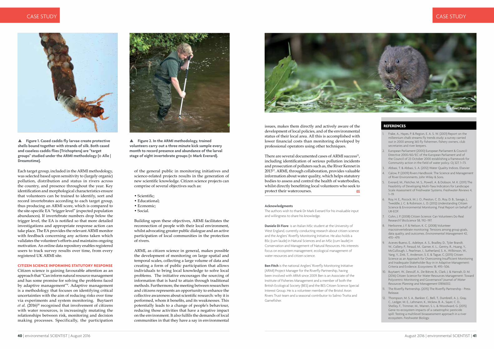
40 | environmental SCIENTIST | August 2016 August 2016 | environmental SCIENTIST | 41
CASE STUDY CASE STUDY
REFERENCES
1. Frake, A., Hayes, P. & Region, E. A. S. W. (2001) Report on the millennium chalk streams fly trends study: a survey carried out in 2000 among 365 fly fishermen, fishery owners, club secretaries and river keepers.
2. European Parliament (2000) European Parliament & Council: Directive 2000/60/EC of the European Parliament and of the Council of 23 October 2000 establishing a framework for Community action in the field of water policy. Oj 327, 1–73.
3. Abbasi, T. & Abbasi, S. A. (2012) Water Quality Indices. Elsevier
4. Calow, P. (2009) Rivers Handbook: The Science and Management of River Environments. John Wiley & Sons.
5. Everard, M., Fletcher, M. S., Powell, A. & Dobson, M. K. (2011) The Feasibility of Developing Multi-Taxa Indicators for Landscape Scale Assessment of Freshwater Systems. Freshwater Reviews 4, 1–19.
6. Roy, H. E., Pocock, M. J. O., Preston, C. D., Roy, D. B., Savage, J., Tweddle, J. C. & Robinson, L. D. (2012) Understanding Citizen Science & Environmental Monitoring. Final Report on behalf of UK-EOF.
7. Cohn, J. P. (2008) Citizen Science: Can Volunteers Do Real Research? BioScience 58, 192–197.
8. Nerbonne, J. F. & Nelson, K. C. (2008) Volunteer macroinvertebrate monitoring: Tensions among group goals, data quality, and outcomes. Environmental Management 42, 470–479.
9. Aceves-Bueno, E., Adeleye, A. S., Bradley, D., Tyler Brandt, W., Callery, P., Feraud, M., Garner, K. L., Gentry, R., Huang, Y., McCullough, I., Pearlman, I., Sutherland, S. A., Wilkinson, W., Yang, Y., Zink, T., Anderson, S. E. & Tague, C. (2015) Citizen Science as an Approach for Overcoming Insufficient Monitoring and Inadequate Stakeholder Buy-in in Adaptive Management: Criteria and Evidence. Ecosystems 18, 493–506.
10. Buytaert, W., Dewulf, A., De Bièvre, B., Clark, J. & Hannah, D. M. (2016) Citizen Science for Water Resources Management: Toward Polycentric Monitoring and Governance? Journal of Water Resources Planning and Management 01816002.
11. The Riverfly Partnership. (2015) The Riverfly Partnership - Press Release.
12. Thompson, M. S. A., Bankier, C., Bell, T., Dumbrell, A. J., Gray, C., Ledger, M. E., Lehmann, K., Mckew, B. A., Sayer, C. D., Shelley, F., Trimmer, M., Warren, S. L. & Woodward, G. (2015) Gene-to-ecosystem impacts of a catastrophic pesticide spill: Testing a multilevel bioassessment approach in a river ecosystem. Freshwater Biology.
Acknowledgments The authors wish to thank Dr Mark Everard for his invaluable input and willingness to share his knowledge.
Daniele Di Fiore is an Italian MSc student at the University of West England, currently conducting research about citizen science and the Anglers’ Riverfly Monitoring Initiative. He also holds a BSc (cum laude) in Natural Sciences and an MSc (cum laude) in Conservation and Management of Natural Resources. His interests focus on ecosystem management, ecological management of water resources and citizen science.
Ben Fitch is the national Anglers’ Riverfly Monitoring Initiative (ARMI) Project Manager for the Riverfly Partnership, having been involved with ARMI since 2009. Ben is an Associate of the Institute of Fisheries Management and a member of both the British Ecological Society (BES) and the BES Citizen Science Special Interest Group. He is a volunteer member of the Bristol Avon Rivers Trust team and a seasonal contributor to Salmo Trutta and Gamefisher.
Each target group, included in the ARMI methodology, was selected based upon sensitivity to (largely organic) pollution, distribution and status in rivers across the country, and presence throughout the year. Key identification and morphological characteristics ensure that volunteers can be trained to identify, sort and record invertebrates according to each target group, thus producing an ARMI score, which is compared to the site-specific EA “trigger level” (expected population abundances). If invertebrate numbers drop below the trigger level, the EA is notified so that more detailed investigations and appropriate response action can take place. The EA provides the relevant ARMI monitor with feedback concerning any actions taken which validates the volunteer’s efforts and maintains ongoing motivation. An online data repository enables registered users to track survey results over time, from every registered UK ARMI site.
CITIZEN SCIENCE INFORMING STATUTORY RESPONSECitizen science is gaining favourable attention as an approach that “Can inform natural resource management and has some promise for solving the problems faced by adaptive management”9. Adaptive management is a methodology that focuses on identifying critical uncertainties with the aim of reducing risks over time via experiments and system monitoring. Buytaert et al. (2016)10 recognised that involvement of citizens with water resources, is increasingly mutating the relationships between risk, monitoring and decision making processes. Specifically, the participation
of the general public in monitoring initiatives and science-related projects results in the generation of new scientific knowledge. Citizen science projects can comprise of several objectives such as:
• Scientific;• Educational;• Economic;• Social.
Building upon these objectives, ARMI facilitates the reconnection of people with their local environment, whilst advocating greater public dialogue and an active participation of local communities in the protection of rivers.
ARMI, as citizen science in general, makes possible the development of monitoring on large spatial and temporal scales, collecting a large volume of data and creating a form of public participation that allows individuals to bring local knowledge to solve local problems. The initiative encourages the sourcing of information that is hard to attain through traditional methods. Furthermore, the meeting between researchers and citizens represents an opportunity to enhance the collective awareness about scientific research: why it is performed, whom it benefits, and its weaknesses. This potentially leads to a change of people’s behaviour, reducing those activities that have a negative impact on the environment. It also fulfils the demands of local communities in that they have a say in environmental
issues, makes them directly and actively aware of the development of local policies, and of the environmental status of their local area. All this is accomplished with lower financial costs than monitoring developed by professional operators using other techniques.
There are several documented cases of ARMI success11, including identification of serious pollution incidents and prosecution of polluters such as, the River Kennet in 201312. ARMI, through collaboration, provides valuable information about water quality, which helps statutory bodies to assess and control the health of waterbodies, whilst directly benefitting local volunteers who seek to protect their watercourses.
Figure 1. Cased caddis fly larvae create protective shells bound together with strands of silk. Both cased and caseless caddis flies (Trichoptera) are "target groups" studied under the ARMI methodology (© Alle | Dreamstime).
Figure 2. In the ARMI methodology, trained volunteers carry out a three minute kick sample every month to record presence and abundance of the larval stage of eight invertebrate groups (© Mark Everard).
© Erni | Fotolia

42 | environmental SCIENTIST | August 2016
CASE STUDYFEATURE FEATURE
During the 18th Century, Selborne and its surrounding landscapes inspired Gilbert White’s life-long investigation of the natural world,
culminating in his world-famous book The Natural History and Antiquities of Selborne. The work of Gilbert White and others stimulated a long tradition of amateur natural history throughout the British Isles, especially throughout the 19th Century. More than 250 years later, these rich and diverse islands continue to inspire tens of thousands of nature enthusiasts across the UK who dedicate considerable time, effort and skill to observing and recording our natural world.
Over 70,000 species of plants, animals and fungi currently occur in the United Kingdom (UK) and with more than 220 voluntary wildlife recording initiatives nationally, it has never been easier to contribute to the understanding of our natural world. However, attitudes towards citizen science and the value of the resulting data vary enormously. This has occurred because of a number of reasons including the unstructured nature of some biological surveys, complex licensing arrangements for shared data, and limitations of the current technical infrastructure for demonstrating the full value of biological data.
THE ROLE OF THE NATIONAL BIODIVERSITY NETWORKThe National Biodiversity Network (NBN), a membership organisation built on the principles of collaboration and sharing, has been championing the sharing of biological data in the UK since 2000. One of its fundamental strategic aims is to improve the availability of high resolution and high quality data to provide the evidence base for all environmental decision-making in the UK. Making the most of the time, hard work and expertise that volunteers donate is important, and we must maximise the use of data obtained by volunteer naturalists and structured citizen science initiatives.
The NBN’s priority is to grow the national commitment to sharing biological data and information, and the NBN Strategy for 2015-2020 outlines how the Network will achieve the vision that:
“Biological data, collected and shared openly by the Network are central to the UK’s learning and understanding of its biodiversity and are critical to all decision-making about nature and the environment”.
The NBN’s members include most of the UK’s national biological recording schemes and societies, many of the UK’s largest wildlife charities and non-governmental organisations, as well as most Local Environmental Record Centres, government agencies, research institutions, ecological consultants, museums, botanic gardens and members of the public.
Building a new biodiversity data infrastructure to support citizen science
Rachel Stroud and Ella Vogel introduce the new and emerging, NBN Atlas of Living Scotland, as the future template for UK wide data infrastructure for biodiversity.
© MarkLG1973 | Adobe stock
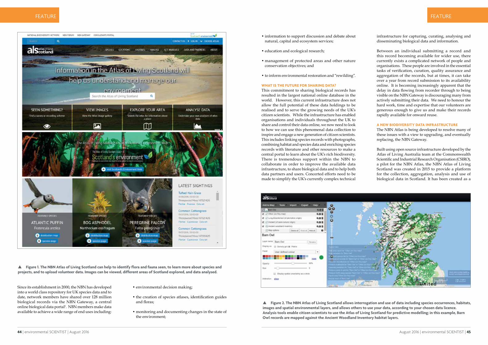
44 | environmental SCIENTIST | August 2016
CASE STUDY
August 2016 | environmental SCIENTIST | 45
FEATURE FEATURE
Since its establishment in 2000, the NBN has developed into a world class repository for UK species data and to date, network members have shared over 128 million biological records via the NBN Gateway, a central online biological data portal1. NBN members make data available to achieve a wide range of end uses including:
• environmental decision making;
• the creation of species atlases, identification guides and floras;
• monitoring and documenting changes in the state of the environment;
• information to support discussion and debate about natural, capital and ecosystem services;
• education and ecological research;
• management of protected areas and other nature conservation objectives; and
• to inform environmental restoration and “rewilding”.
WHAT IS THE FUTURE FOR SHARING DATA?This commitment to sharing biological records has resulted in the largest national online database in the world. However, this current infrastructure does not allow the full potential of these data holdings to be realised and to serve the growing needs of the UK’s citizen scientists. While the infrastructure has enabled organisations and individuals throughout the UK to share and control their data online, we now need to look to how we can use this phenomenal data collection to inspire and engage a new generation of citizen scientists. This includes linking species records with photographs, combining habitat and species data and enriching species records with literature and other resources to make a central portal to learn about the UK’s rich biodiversity. There is tremendous support within the NBN to collaborate in order to improve the available data infrastructure, to share biological data and to help both data partners and users. Concerted efforts need to be made to simplify the UK’s currently complex technical
infrastructure for capturing, curating, analysing and disseminating biological data and information.
Between an individual submitting a record and this record becoming available for wider use, there currently exists a complicated network of people and organisations. These people are involved in the essential tasks of verification, curation, quality assurance and aggregation of the records, but at times, it can take over a year from record submission to its availability online. It is becoming increasingly apparent that the delay in data flowing from recorder through to being visible on the NBN Gateway is discouraging many from actively submitting their data. We need to honour the hard work, time and expertise that our volunteers are generous enough to give us and make their records rapidly available for onward reuse.
A NEW BIODIVERSITY DATA INFRASTRUCTUREThe NBN Atlas is being developed to resolve many of these issues with a view to upgrading, and eventually replacing, the NBN Gateway.
Built using open source infrastructure developed by the Atlas of Living Australia team at the Commonwealth Scientific and Industrial Research Organisation (CSIRO), a pilot for the NBN Atlas, the NBN Atlas of Living Scotland was created in 2015 to provide a platform for the collection, aggregation, analysis and use of biological data in Scotland. It has been created as a
????/
Figure 1. The NBN Atlas of Living Scotland can help to identify flora and fauna seen, to learn more about species and projects, and to upload volunteer data. Images can be viewed, different areas of Scotland explored, and data analysed.
Figure 2. The NBN Atlas of Living Scotland allows interrogation and use of data including species occurrences, habitats, images and spatial environmental layers, and allows others to use your data, according to your chosen data licence. Analysis tools enable citizen scientists to use the Atlas of Living Scotland for predictive modelling; in this example, Barn Owl records are mapped against the Ancient Woodland Inventory habitat layers.
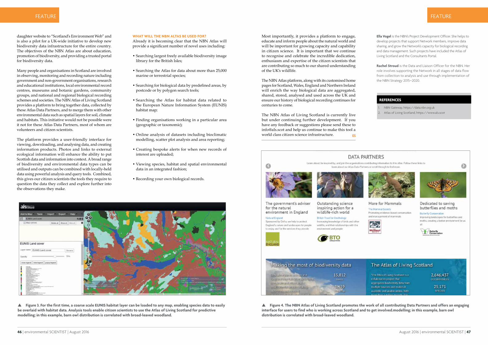
46 | environmental SCIENTIST | August 2016
CASE STUDY
August 2016 | environmental SCIENTIST | 47
FEATURE FEATURE
REFERENCES
1. NBN Gateway, https://data.nbn.org.uk
2. Atlas of Living Scotland, https://www.als.scot
Ella Vogel is the NBN's Project Development Officer. She helps to develop projects that support Network members, improve data sharing, and grow the Network's capacity for biological recording and data management. Such projects have included the Atlas of Living Scotland and the Consultants Portal.
Rachel Stroud is the Data and Liaison Officer for the NBN. Her role involves supporting the Network in all stages of data flow from collection to analysis and use through implementation of the NBN Strategy 2015–2020.
daughter website to “Scotland’s Environment Web” and is also a pilot for a UK-wide initiative to develop new biodiversity data infrastructure for the entire country. The objectives of the NBN Atlas are about education, promotion of biodiversity, and providing a trusted portal for biodiversity data.
Many people and organisations in Scotland are involved in observing, monitoring and recording nature including government and non-government organisations, research and educational institutions, local environmental record centres, museums and botanic gardens, community groups, and national and regional biological recording schemes and societies. The NBN Atlas of Living Scotland provides a platform to bring together data, collected by these Atlas Data Partners, and to merge them with other environmental data such as spatial layers for soil, climate and habitats. This initiative would not be possible were it not for these Atlas Data Partners, most of whom are volunteers and citizen scientists.
The platform provides a user-friendly interface for viewing, downloading, and analysing data, and creating information products. Photos and links to external ecological information will enhance the ability to put Scottish data and information into context. A broad range of biodiversity and environmental data types can be utilised and outputs can be combined with locally-held data using powerful analysis and query tools. Combined, this gives our citizen scientists the tools they require to question the data they collect and explore further into the observations they make.
WHAT WILL THE NBN ALTAS BE USED FOR?Already it is becoming clear that the NBN Atlas will provide a significant number of novel uses including:
• Searching largest freely available biodiversity image library for the British Isles;
• Searching the Atlas for data about more than 25,000 marine or terrestrial species;
• Searching for biological data by predefined areas, by postcode or by polygon search tools;
• Searching the Atlas for habitat data related to the European Nature Information System (EUNIS) habitat map;
• Finding organisations working in a particular area (geographic or taxonomic);
• Online analysis of datasets including bioclimatic modelling, scatter plot analysis and area reporting;
• Creating bespoke alerts for when new records of interest are uploaded;
• Viewing species, habitat and spatial environmental data in an integrated fashion;
• Recording your own biological records.
Figure 3. For the first time, a coarse scale EUNIS habitat layer can be loaded to any map, enabling species data to easily be overlaid with habitat data. Analysis tools enable citizen scientists to use the Atlas of Living Scotland for predictive modelling; in this example, barn owl distribution is correlated with broad-leaved woodland.
Figure 4. The NBN Atlas of Living Scotland promotes the work of all contributing Data Partners and offers an engaging interface for users to find who is working across Scotland and to get involved.modelling; in this example, barn owl distribution is correlated with broad-leaved woodland.
Most importantly, it provides a platform to engage, educate and inform people about the natural world and will be important for growing capacity and capability in citizen science. It is important that we continue to recognise and celebrate the incredible dedication, enthusiasm and expertise of the citizen scientists that are contributing so much to our shared understanding of the UK’s wildlife.
The NBN Atlas platform, along with its customised home pages for Scotland, Wales, England and Northern Ireland will enrich the way biological data are aggregated, shared, stored, analysed and used across the UK and ensure our history of biological recording continues for centuries to come.
The NBN Atlas of Living Scotland is currently live but under continuing further development. If you have any feedback or suggestions please send these to [email protected] and help us continue to make this tool a world class citizen science infrastructure.
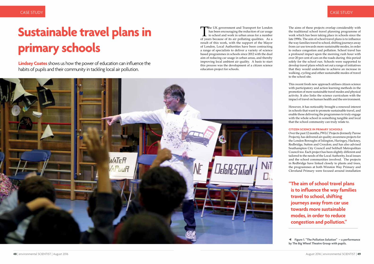
48 | environmental SCIENTIST | August 2016 August 2016 | environmental SCIENTIST | 49
CASE STUDY CASE STUDY
Sustainable travel plans in primary schoolsLindsey Coates shows us how the power of education can influence the habits of pupils and their community in tackling local air pollution.
The aims of these projects overlap considerably with the traditional school travel planning programme of work which has been taking place in schools since the late 1990s. The aim of school travel plans is to influence the way families travel to school, shifting journeys away from car use towards more sustainable modes, in order to reduce congestion and pollution. School travel has a profound impact upon the morning rush hour with over 20 per cent of cars on the roads during this period solely for the school run. Schools were supported to develop travel plans which set out a range of initiatives that they would undertake to achieve an increase in walking, cycling and other sustainable modes of travel to the school site.
This recent fresh new approach utilises citizen science with participatory and action learning methods in the promotion of more sustainable travel modes and physical activity. It also links the science curriculum with the impact of travel on human health and the environment.
However, it has noticeably brought a renewed interest in schools that want to promote sustainable travel, and enable those delivering the programmes to truly engage with the whole school in something tangible and local that the school community can truly relate to.
CITIZEN SCIENCE IN PRIMARY SCHOOLSOver the past 12 months, PWLC Projects (formerly Parose Projects), has delivered air quality awareness projects for the London Boroughs of Islington, Haringey, Hackney, Redbridge, Sutton and Croydon; and has also advised Southampton City Council and Solihull Metropolitan Council too. Each project has been slightly different and tailored to the needs of the Local Authority, local issues and the school communities involved. The projects in Redbridge have linked closely to plants and trees, the programmes at both Winston Way Primary and Cleveland Primary were focused around installation
The UK government and Transport for London has been encouraging the reduction of car usage to school and work in urban areas for a number
of years because of its air polluting qualities. As a result of this work, with the support of the Mayor of London, Local Authorities have been contracting a range of specialists to deliver a variety of science based programmes in schools since 2012 with the dual aim of reducing car usage in urban areas, and thereby improving local ambient air quality. A basis to start this process was the development of a citizen science education project for schools.
“ The aim of school travel plans is to influence the way families travel to school, shifting journeys away from car use towards more sustainable modes, in order to reduce congestion and pollution.”
Figure 1. ”The Pollution Solution” – a performance by The Big Wheel Theatre Group with pupils.
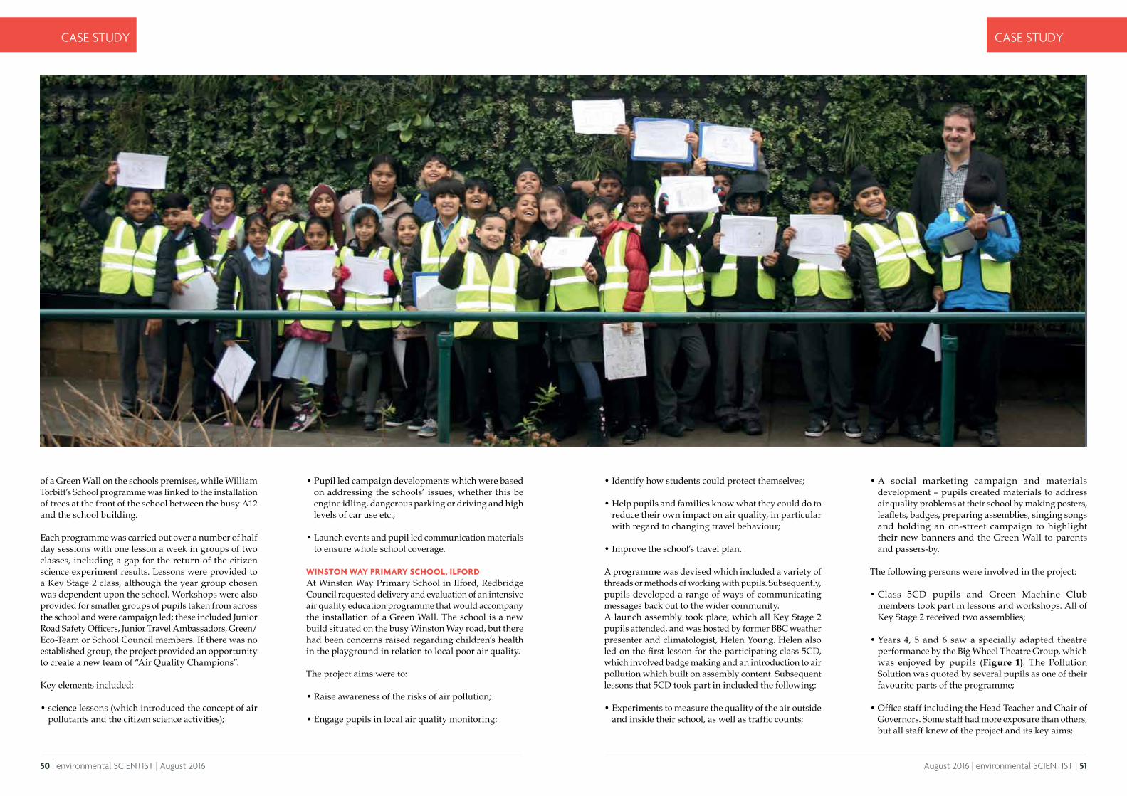
50 | environmental SCIENTIST | August 2016 August 2016 | environmental SCIENTIST | 51
CASE STUDY CASE STUDY
of a Green Wall on the schools premises, while William Torbitt’s School programme was linked to the installation of trees at the front of the school between the busy A12 and the school building.
Each programme was carried out over a number of half day sessions with one lesson a week in groups of two classes, including a gap for the return of the citizen science experiment results. Lessons were provided to a Key Stage 2 class, although the year group chosen was dependent upon the school. Workshops were also provided for smaller groups of pupils taken from across the school and were campaign led; these included Junior Road Safety Officers, Junior Travel Ambassadors, Green/Eco-Team or School Council members. If there was no established group, the project provided an opportunity to create a new team of “Air Quality Champions”.
Key elements included:
• science lessons (which introduced the concept of air pollutants and the citizen science activities);
• Pupil led campaign developments which were based on addressing the schools’ issues, whether this be engine idling, dangerous parking or driving and high levels of car use etc.;
• Launch events and pupil led communication materials to ensure whole school coverage.
WINSTON WAY PRIMARY SCHOOL, ILFORD At Winston Way Primary School in Ilford, Redbridge Council requested delivery and evaluation of an intensive air quality education programme that would accompany the installation of a Green Wall. The school is a new build situated on the busy Winston Way road, but there had been concerns raised regarding children’s health in the playground in relation to local poor air quality.
The project aims were to:
• Raise awareness of the risks of air pollution;
• Engage pupils in local air quality monitoring;
• Identify how students could protect themselves;
• Help pupils and families know what they could do to reduce their own impact on air quality, in particular with regard to changing travel behaviour;
• Improve the school’s travel plan.
A programme was devised which included a variety of threads or methods of working with pupils. Subsequently, pupils developed a range of ways of communicating messages back out to the wider community.A launch assembly took place, which all Key Stage 2 pupils attended, and was hosted by former BBC weather presenter and climatologist, Helen Young. Helen also led on the first lesson for the participating class 5CD, which involved badge making and an introduction to air pollution which built on assembly content. Subsequent lessons that 5CD took part in included the following:
• Experiments to measure the quality of the air outside and inside their school, as well as traffic counts;
• A social marketing campaign and materials development – pupils created materials to address air quality problems at their school by making posters, leaflets, badges, preparing assemblies, singing songs and holding an on-street campaign to highlight their new banners and the Green Wall to parents and passers-by.
The following persons were involved in the project:
• Class 5CD pupils and Green Machine Club members took part in lessons and workshops. All of Key Stage 2 received two assemblies;
• Years 4, 5 and 6 saw a specially adapted theatre performance by the Big Wheel Theatre Group, which was enjoyed by pupils (Figure 1). The Pollution Solution was quoted by several pupils as one of their favourite parts of the programme;
• Office staff including the Head Teacher and Chair of Governors. Some staff had more exposure than others, but all staff knew of the project and its key aims;
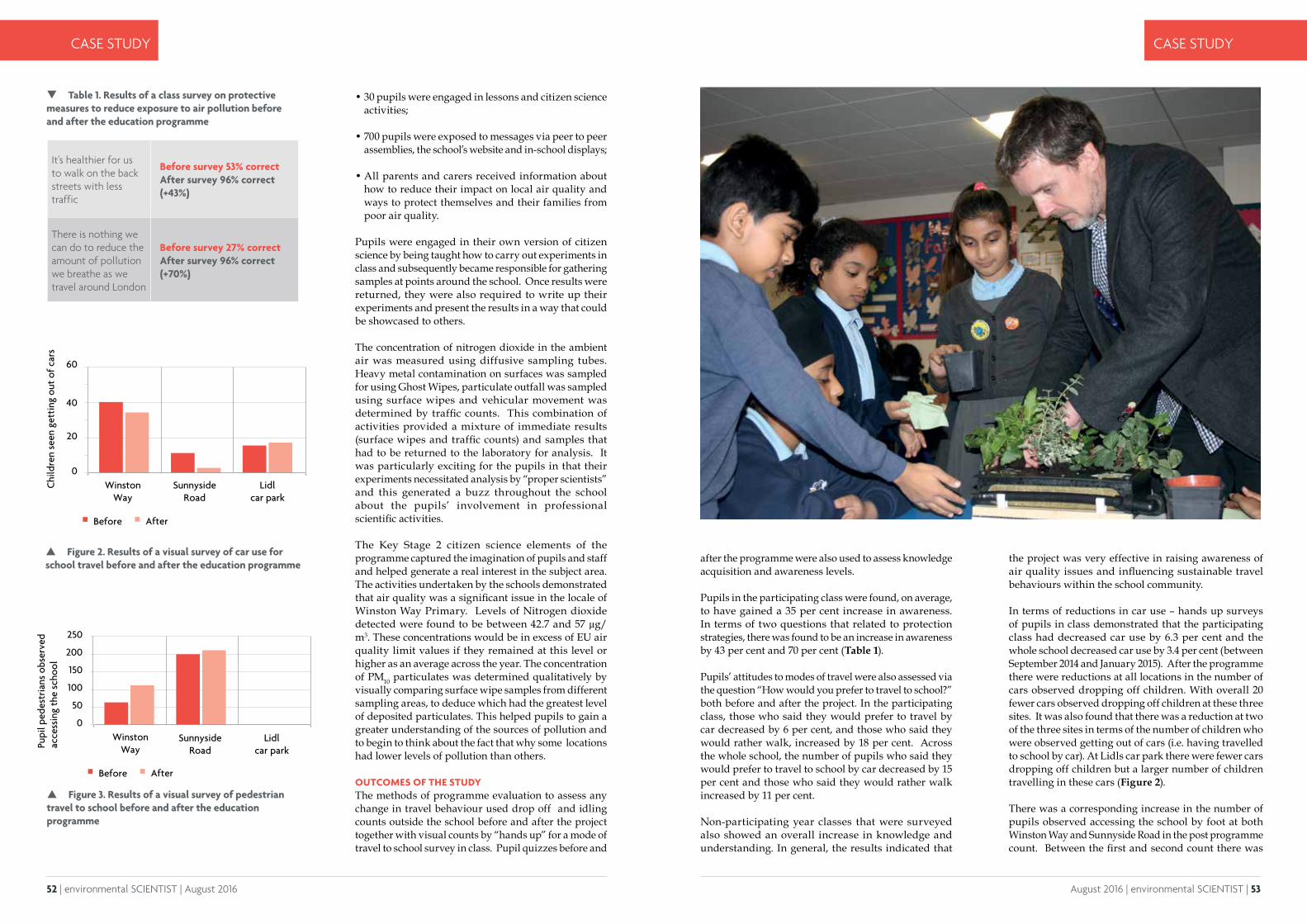
52 | environmental SCIENTIST | August 2016 August 2016 | environmental SCIENTIST | 53
CASE STUDY CASE STUDY
after the programme were also used to assess knowledge acquisition and awareness levels.
Pupils in the participating class were found, on average, to have gained a 35 per cent increase in awareness. In terms of two questions that related to protection strategies, there was found to be an increase in awareness by 43 per cent and 70 per cent (Table 1).
Pupils’ attitudes to modes of travel were also assessed via the question “How would you prefer to travel to school?” both before and after the project. In the participating class, those who said they would prefer to travel by car decreased by 6 per cent, and those who said they would rather walk, increased by 18 per cent. Across the whole school, the number of pupils who said they would prefer to travel to school by car decreased by 15 per cent and those who said they would rather walk increased by 11 per cent.
Non-participating year classes that were surveyed also showed an overall increase in knowledge and understanding. In general, the results indicated that
Figure 2. Results of a visual survey of car use for school travel before and after the education programme
Figure 3. Results of a visual survey of pedestrian travel to school before and after the education programme
WinstonWay
SunnysideRoad
Lidl car park
0
20748*"9.:"
40
60
Chi
ldre
n se
en g
etti
ng o
ut o
f car
s
Before After
WinstonWay
SunnysideRoad
Lidl car park
Before After
0
100
150
200
250
50
748*"9.:"
Pupi
l ped
estr
ians
obs
erve
d ac
cess
ing
the
scho
ol
• 30 pupils were engaged in lessons and citizen science activities;
• 700 pupils were exposed to messages via peer to peer assemblies, the school’s website and in-school displays;
• All parents and carers received information about how to reduce their impact on local air quality and ways to protect themselves and their families from poor air quality.
Pupils were engaged in their own version of citizen science by being taught how to carry out experiments in class and subsequently became responsible for gathering samples at points around the school. Once results were returned, they were also required to write up their experiments and present the results in a way that could be showcased to others.
The concentration of nitrogen dioxide in the ambient air was measured using diffusive sampling tubes. Heavy metal contamination on surfaces was sampled for using Ghost Wipes, particulate outfall was sampled using surface wipes and vehicular movement was determined by traffic counts. This combination of activities provided a mixture of immediate results (surface wipes and traffic counts) and samples that had to be returned to the laboratory for analysis. It was particularly exciting for the pupils in that their experiments necessitated analysis by “proper scientists” and this generated a buzz throughout the school about the pupils’ involvement in professional scientific activities.
The Key Stage 2 citizen science elements of the programme captured the imagination of pupils and staff and helped generate a real interest in the subject area. The activities undertaken by the schools demonstrated that air quality was a significant issue in the locale of Winston Way Primary. Levels of Nitrogen dioxide detected were found to be between 42.7 and 57 μg/m3. These concentrations would be in excess of EU air quality limit values if they remained at this level or higher as an average across the year. The concentration of PM10 particulates was determined qualitatively by visually comparing surface wipe samples from different sampling areas, to deduce which had the greatest level of deposited particulates. This helped pupils to gain a greater understanding of the sources of pollution and to begin to think about the fact that why some locations had lower levels of pollution than others.
OUTCOMES OF THE STUDY The methods of programme evaluation to assess any change in travel behaviour used drop off and idling counts outside the school before and after the project together with visual counts by “hands up” for a mode of travel to school survey in class. Pupil quizzes before and
the project was very effective in raising awareness of air quality issues and influencing sustainable travel behaviours within the school community.
In terms of reductions in car use – hands up surveys of pupils in class demonstrated that the participating class had decreased car use by 6.3 per cent and the whole school decreased car use by 3.4 per cent (between September 2014 and January 2015). After the programme there were reductions at all locations in the number of cars observed dropping off children. With overall 20 fewer cars observed dropping off children at these three sites. It was also found that there was a reduction at two of the three sites in terms of the number of children who were observed getting out of cars (i.e. having travelled to school by car). At Lidls car park there were fewer cars dropping off children but a larger number of children travelling in these cars (Figure 2).
There was a corresponding increase in the number of pupils observed accessing the school by foot at both Winston Way and Sunnyside Road in the post programme count. Between the first and second count there was
Table 1. Results of a class survey on protective measures to reduce exposure to air pollution before and after the education programme
It's healthier for us to walk on the back streets with less traffic
Before survey 53% correct After survey 96% correct (+43%)
There is nothing we can do to reduce the amount of pollution we breathe as we travel around London
Before survey 27% correct After survey 96% correct (+70%)
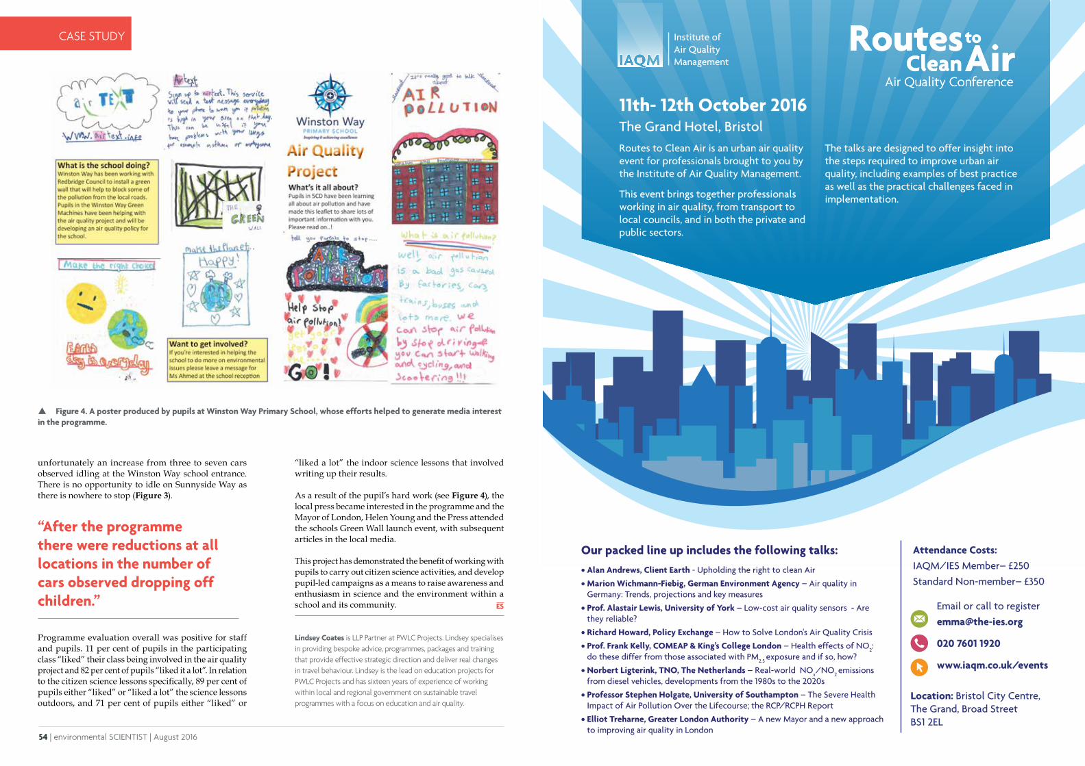
54 | environmental SCIENTIST | August 2016
CASE STUDY
Lindsey Coates is LLP Partner at PWLC Projects. Lindsey specialises in providing bespoke advice, programmes, packages and training that provide effective strategic direction and deliver real changes in travel behaviour. Lindsey is the lead on education projects for PWLC Projects and has sixteen years of experience of working within local and regional government on sustainable travel programmes with a focus on education and air quality.
unfortunately an increase from three to seven cars observed idling at the Winston Way school entrance. There is no opportunity to idle on Sunnyside Way as there is nowhere to stop (Figure 3).
Programme evaluation overall was positive for staff and pupils. 11 per cent of pupils in the participating class “liked” their class being involved in the air quality project and 82 per cent of pupils “liked it a lot”. In relation to the citizen science lessons specifically, 89 per cent of pupils either “liked” or “liked a lot” the science lessons outdoors, and 71 per cent of pupils either “liked” or
“After the programme there were reductions at all locations in the number of cars observed dropping off children.”
Figure 4. A poster produced by pupils at Winston Way Primary School, whose efforts helped to generate media interest in the programme.
Our packed line up includes the following talks:• Alan Andrews, Client Earth - Upholding the right to clean Air
• Marion Wichmann-Fiebig, German Environment Agency – Air quality in Germany: Trends, projections and key measures
• Prof. Alastair Lewis, University of York – Low-cost air quality sensors - Are they reliable?
• Richard Howard, Policy Exchange – How to Solve London's Air Quality Crisis
• Prof. Frank Kelly, COMEAP & King’s College London – Health effects of NO2: do these differ from those associated with PM2.5 exposure and if so, how?
• Norbert Ligterink, TNO, The Netherlands – Real-world NOx/NO2 emissions
from diesel vehicles, developments from the 1980s to the 2020s
• Professor Stephen Holgate, University of Southampton – The Severe Health Impact of Air Pollution Over the Lifecourse; the RCP/RCPH Report
• Elliot Treharne, Greater London Authority – A new Mayor and a new approach to improving air quality in London
Attendance Costs:IAQM/IES Member– £250Standard Non-member– £350
Email or call to [email protected]
020 7601 1920
www.iaqm.co.uk/events
Institute ofAir Quality Management
C
M
Y
CM
MY
CY
CMY
K
iaqm_logo.pdf 1 15/01/2015 15:17
Location: Bristol City Centre, The Grand, Broad Street BS1 2EL
“liked a lot” the indoor science lessons that involved writing up their results. As a result of the pupil’s hard work (see Figure 4), the local press became interested in the programme and the Mayor of London, Helen Young and the Press attended the schools Green Wall launch event, with subsequent articles in the local media.
This project has demonstrated the benefit of working with pupils to carry out citizen science activities, and develop pupil-led campaigns as a means to raise awareness and enthusiasm in science and the environment within a school and its community.
11th- 12th October 2016The Grand Hotel, Bristol Routes to Clean Air is an urban air quality event for professionals brought to you by the Institute of Air Quality Management.
This event brings together professionals working in air quality, from transport to local councils, and in both the private and public sectors.
The talks are designed to offer insight into the steps required to improve urban air quality, including examples of best practice as well as the practical challenges faced in implementation.

56 | environmental SCIENTIST | August 2016
CASE STUDY
August 2016 | environmental SCIENTIST | 57
FEATURE FEATURE
The WeSenseIt project defines citizen observatories as “A method, an environment and an infrastructure supporting an information ecosystem for
communities and citizens, as well as emergency operators and policymakers, for discussion, monitoring and intervention on situations, places and events”1. A collaborative approach has been taken to develop solutions that involve an exchange of information and expertise from all participants and where the focus is on arriving at practical solutions with a clear vision and direction. This has created a shared ownership scheme, and shifts power to the process itself rather than remaining within authorities, developers or decision-makers2. The project’s emphasis is on delivering highly innovative technologies to support citizens, communities and authorities in developing a real-time situation awareness while ensuring all stakeholders play their part. Implementation has been through a combination of crowdsourcing, custom applications and dedicated web portals designed to foster collaboration, and which has created a shared knowledge base that facilitates decision-making processes and engages with communities. Data is captured via innovative sensors that are used directly by citizens and crowdsourcing from social networks (or by collective intelligence). We illustrate the different players and stakeholders in Figure 1.
The concentric circles in Figure 1 indicate the different types of information that are collected and shared3. Among each concentric circle, a variety of stakeholders are indicated - emergency services, people involved
Citizen observatories for effective Earth observations: the WeSenseIt ApproachSuvodeep Mazumdar, Vita Lanfranchi, Neil Ireson, Stuart Wrigley, Clara Bagnasco, Uta Wehn, Rosalind McDonagh, Michele Ferri, Simon McCarthy, Hendrik Huwald and Fabio Ciravegna describe how “citizen observatories” have been created with the help of new technology to allow the public to collaborate with authorities and organisations in day to day and emergency water management issues.
in an emergency, explicit sensors (people actively contributing information via mobile and online systems through participatory crowdsourcing), and implicit sensors (people sharing information via social media, opportunistically crowdsourced to identify critical relevant information). A variety of applications and systems have been developed in the project to address each type of information need and stakeholder.
CITIZENS AS SENSORS Real-time high quality sensors provide “live” ground information on the current environmental conditions of a locality, and hence are critical to the understanding of areas of interest. Data from sensors are processed in a variety of ways and made available to decision makers as visualisations, predictive analyses or real-time alerts and triggers. All of these approaches together help inform decision makers of the existing and predicted conditions at specific locations. High precision sensors are highly expensive, need constant maintenance and are static, but can provide high volumes of data regarding areas that have been previously determined to be of interest. However, with the rapidly evolving environmental conditions and landscapes, critical areas of interest can be dynamic and different areas in cities can be of interest at different times. This challenge has been addressed by the development and deployment of low-cost sensor technology, as well as maintaining communication between citizens and the authorities.
A variety of information can be provided by citizens and key to their participatory role is the large scale installation of low cost analogue devices across wide geographical areas. Examples of such devices are water depth gauge boards and snow depth gauge boards, which need to be manually 'read' by counting clear numerical markings on the boards. They are relatively cheap to manufacture, require very little maintenance and can be installed at a large number of locations such as, rivers, canals, locks, waterways and so on. Citizens can quickly visually read the gauge boards and provide the information to the authorities via a smartphone or desktop application (app). In addition to the visual observation of analogue sensors, the WeSenseIt project has also developed several low cost electronic sensors using Raspberry Pi and Arduino platforms. These have been developed as small mobile devices which can provide data on local air temperature, barometric pressure, light levels as well as estimating water course flow rate (Figure 2). The devices are lightweight, portable, easy to adapt and flexible, and the data collected is periodically transmitted to the WeSenseIt data hub. A variety of user communities can use such sensors and citizen scientists, hobbyists and enthusiasts can build their own sensors using technical details provided by the project. A large number of sensors have also been distributed to volunteer flood wardens.
EMERGENCY SERVICES
PEOPLE INVOLVED IN AN EMERGENCY
DIGITALLY ACTIVE PEOPLE (EXPLICITE SENSORS)
SOCIAL MEDIA SPHERE (IMPLICIT SENSORS)
Figure 1. The WeSenseIt Citizens’ Observatory Model© HandmadePictures | Dreamstime
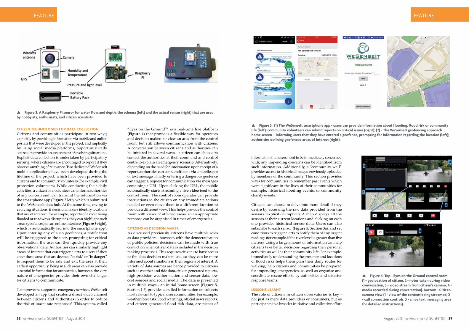
58 | environmental SCIENTIST | August 2016
CASE STUDY
August 2016 | environmental SCIENTIST | 59
FEATURE FEATURE
CITIZEN TECHNOLOGIES FOR DATA COLLECTIONCitizens and communities participate in two ways; explicitly by providing information via mobile and online portals that were developed in the project, and implicitly by using social media platforms, opportunistically sourced to provide an assessment of evolving situations. Explicit data collection is undertaken by participatory sensing, where citizens are encouraged to report if they observe anything of relevance. Two dedicated WeSenseIt mobile applications have been developed during the lifetime of the project, which have been provided to citizens and to community volunteers (for example, civil protection volunteers). While conducting their daily activities, a citizen or a volunteer can inform authorities of any concern and can transmit the information via the smartphone app (Figure 3 left), which is submitted to the WeSenseIt data hub. At the same time, owing to evolving situations, if decision makers identify locations that are of interest (for example, reports of a river being flooded or roadways disrupted), they can highlight such areas (geofences) on an online interface (Figure 3 right), which is automatically fed into the smartphone app4. Upon entering any of such geofences, a notification will be triggered to the user, prompting for critical information; the user can then quickly provide any observational data. Authorities can similarly highlight areas of interest that can trigger alerts to users if they enter those areas that are deemed “at-risk” or “in danger” to request them to be safe and exit the area at their earliest opportunity. Being in such areas can also provide essential information for authorities, however, the very nature of emergencies provides their own challenges for citizens to communicate.
To improve the support to emergency services, WeSenseIt developed an app that creates a direct video channel between citizens and authorities in order to reduce the risk of inaccurate responses5. This system, called
“Eyes on the Ground”6, is a real-time live platform (Figure 4) that provides a flexible way for operators and decision makers to view an area from the control room, but still allows communication with citizens.A conversation between citizens and authorities can be initiated in several ways - a citizen can choose to contact the authorities at their command and control centre to explain an emergency scenario. Alternatively, depending on the need for information upon receipt of a report, authorities can contact citizens via a mobile app or text message. Finally, entering a dangerous geofence can trigger a request for communication via messages containing a URL. Upon clicking the URL, the mobile automatically starts streaming a live video feed to the control room. The control room operator can provide instructions to the citizen on any immediate actions needed or even move them to a different location to provide a different view. This helps provide the control room with views of affected areas, so an appropriate response can be organised in times of emergencies
CITIZENS AS DECISION MAKERAs discussed previously, citizens have multiple roles as data providers - however, with the democratisation of public policies, decisions can be made with true conviction when citizen data is included in the decision making processes. This requires citizens to have access to the data decision-makers use, so they can be more informed about situations in their regions of interest. A variety of data sources are hence provided to citizens such as weather and tide data, citizen generated reports, high precision weather station and sensor data, low cost sensors and social media. The data is presented in multiple ways - an initial home screen (Figure 5, Section 1-3) provides detailed information on subjects most relevant to typical user communities. For example, weather forecasts, flood warnings, official news reports, and citizen generated flood risk data, are pieces of
Figure 2. A Raspberry Pi sensor for water flow and depth: the schema (left) and the actual sensor (right) that are used by hobbyists, enthusiasts, and citizen scientists.
Figure 3. (1) The WeSenseIt smartphone app - users can provide information about flooding, flood risk or community life (left); community volunteers can submit reports on critical issues (right); (2) - The WeSenseIt geofencing approach home screen - informing users that they have entered a geofence, prompting for information regarding the location (left); authorities defining geofenced areas of interest (right).
Figure 4. Top - Eyes on the Ground control room (1 - geolocation of citizen, 2 - notes taken during video conversation, 3 - video stream from citizen’s camera, 4 - media recorded during conversation). Bottom - Citizen camera view (1 - view of the content being streamed, 2 - call connection controls, 3 - a live text messaging area for detailed instructions).
information that users need to be immediately concerned with; any impending concerns can be identified from such information. Additionally, a “community wall” provides access to historical images previously uploaded by members of the community. This section provides ways for communities to remember past events which were significant in the lives of their communities for example, historical flooding events, or community charity events.
Citizens can choose to delve into more detail if they desire by accessing the raw data provided from the sensors (explicit or implicit). A map displays all the sensors at their current locations and clicking on each one provides historical sensor data. Users can also subscribe to each sensor (Figure 5, Section 3a), and set conditions to trigger alerts to notify them of any urgent readings (for example, if the river level is greater than five metres). Using a large amount of information can help citizens take better decisions regarding their personal activities as well as their community life. For example, immediately understanding the presence and locations of flood risks helps them plan their daily routes for walking, help citizens and communities be prepared for impending emergencies, as well as organise and coordinate rescue efforts by authorities and disaster response teams.
LESSONS LEARNTThe role of citizens in citizen observatories is key - not just as mere data providers or consumers, but as participants in a broader initiative and collective effort
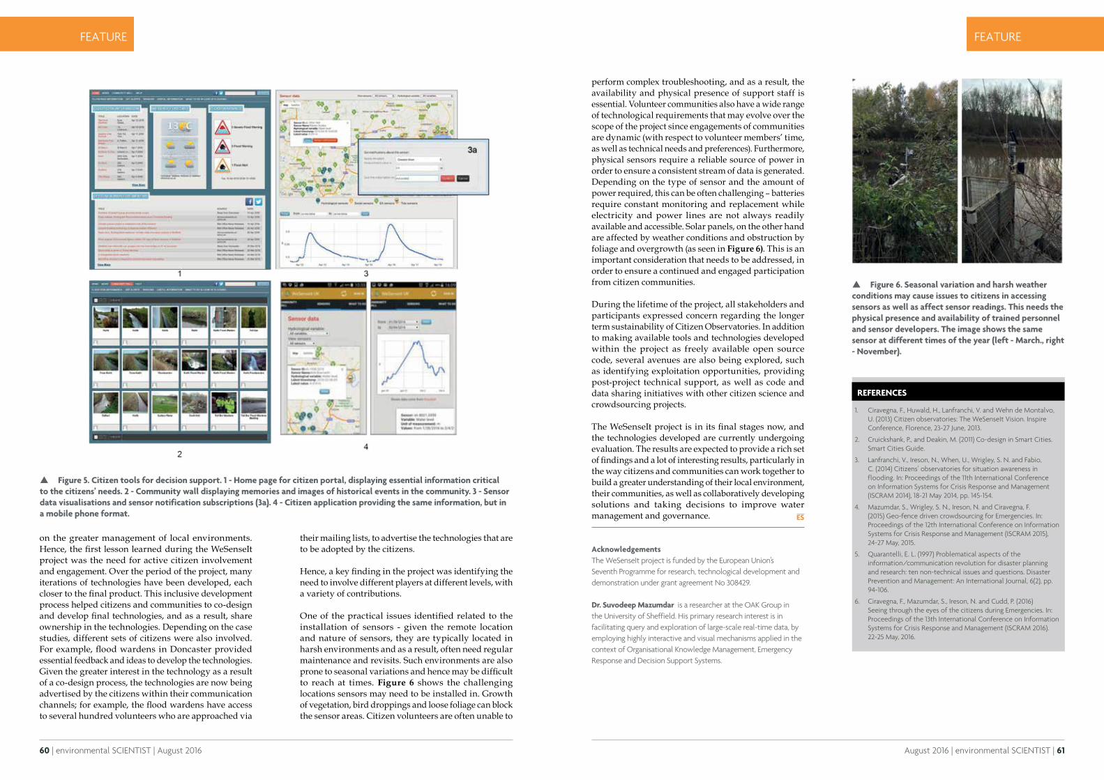
60 | environmental SCIENTIST | August 2016
CASE STUDY
August 2016 | environmental SCIENTIST | 61
FEATURE FEATURE
on the greater management of local environments. Hence, the first lesson learned during the WeSenseIt project was the need for active citizen involvement and engagement. Over the period of the project, many iterations of technologies have been developed, each closer to the final product. This inclusive development process helped citizens and communities to co-design and develop final technologies, and as a result, share ownership in the technologies. Depending on the case studies, different sets of citizens were also involved. For example, flood wardens in Doncaster provided essential feedback and ideas to develop the technologies. Given the greater interest in the technology as a result of a co-design process, the technologies are now being advertised by the citizens within their communication channels; for example, the flood wardens have access to several hundred volunteers who are approached via
their mailing lists, to advertise the technologies that are to be adopted by the citizens.
Hence, a key finding in the project was identifying the need to involve different players at different levels, with a variety of contributions.
One of the practical issues identified related to the installation of sensors - given the remote location and nature of sensors, they are typically located in harsh environments and as a result, often need regular maintenance and revisits. Such environments are also prone to seasonal variations and hence may be difficult to reach at times. Figure 6 shows the challenging locations sensors may need to be installed in. Growth of vegetation, bird droppings and loose foliage can block the sensor areas. Citizen volunteers are often unable to
Figure 5. Citizen tools for decision support. 1 - Home page for citizen portal, displaying essential information critical to the citizens’ needs. 2 - Community wall displaying memories and images of historical events in the community. 3 - Sensor data visualisations and sensor notification subscriptions (3a). 4 - Citizen application providing the same information, but in a mobile phone format.
perform complex troubleshooting, and as a result, the availability and physical presence of support staff is essential. Volunteer communities also have a wide range of technological requirements that may evolve over the scope of the project since engagements of communities are dynamic (with respect to volunteer members’ time, as well as technical needs and preferences). Furthermore, physical sensors require a reliable source of power in order to ensure a consistent stream of data is generated. Depending on the type of sensor and the amount of power required, this can be often challenging – batteries require constant monitoring and replacement while electricity and power lines are not always readily available and accessible. Solar panels, on the other hand are affected by weather conditions and obstruction by foliage and overgrowth (as seen in Figure 6). This is an important consideration that needs to be addressed, in order to ensure a continued and engaged participation from citizen communities.
During the lifetime of the project, all stakeholders and participants expressed concern regarding the longer term sustainability of Citizen Observatories. In addition to making available tools and technologies developed within the project as freely available open source code, several avenues are also being explored, such as identifying exploitation opportunities, providing post-project technical support, as well as code and data sharing initiatives with other citizen science and crowdsourcing projects.
The WeSenseIt project is in its final stages now, and the technologies developed are currently undergoing evaluation. The results are expected to provide a rich set of findings and a lot of interesting results, particularly in the way citizens and communities can work together to build a greater understanding of their local environment, their communities, as well as collaboratively developing solutions and taking decisions to improve water management and governance.
AcknowledgementsThe WeSenseIt project is funded by the European Union’s Seventh Programme for research, technological development and demonstration under grant agreement No 308429.
Dr. Suvodeep Mazumdar is a researcher at the OAK Group in the University of Sheffield. His primary research interest is in facilitating query and exploration of large-scale real-time data, by employing highly interactive and visual mechanisms applied in the context of Organisational Knowledge Management, Emergency Response and Decision Support Systems.
REFERENCES
1. Ciravegna, F., Huwald, H., Lanfranchi, V. and Wehn de Montalvo, U. (2013) Citizen observatories: The WeSenseIt Vision. Inspire Conference, Florence, 23-27 June, 2013.
2. Cruickshank, P., and Deakin, M. (2011) Co-design in Smart Cities. Smart Cities Guide.
3. Lanfranchi, V., Ireson, N., When, U., Wrigley, S. N. and Fabio, C. (2014) Citizens’ observatories for situation awareness in flooding. In: Proceedings of the 11th International Conference on Information Systems for Crisis Response and Management (ISCRAM 2014), 18-21 May 2014, pp. 145-154.
4. Mazumdar, S., Wrigley, S. N., Ireson, N. and Ciravegna, F. (2015) Geo-fence driven crowdsourcing for Emergencies. In: Proceedings of the 12th International Conference on Information Systems for Crisis Response and Management (ISCRAM 2015), 24-27 May, 2015.
5. Quarantelli, E. L. (1997) Problematical aspects of the information/communication revolution for disaster planning and research: ten non-technical issues and questions. Disaster Prevention and Management: An International Journal, 6(2), pp. 94-106.
6. Ciravegna, F., Mazumdar, S., Ireson, N. and Cudd, P. (2016) Seeing through the eyes of the citizens during Emergencies. In: Proceedings of the 13th International Conference on Information Systems for Crisis Response and Management (ISCRAM 2016). 22-25 May, 2016.
Figure 6. Seasonal variation and harsh weather conditions may cause issues to citizens in accessing sensors as well as affect sensor readings. This needs the physical presence and availability of trained personnel and sensor developers. The image shows the same sensor at different times of the year (left - March., right - November).

62 | environmental SCIENTIST | August 2016
CASE STUDYFEATURE FEATURE
Promoting freshwater sustainability through citizen science
Steven Loiselle describes the success of FreshWater Watch in generating public engagement and harnessing their skills to improve local waterways.
Freshwater is one of the greatest issues facing modern society; lack of availability and diminishing quality are of huge concern to a planet with a
growing population.
FreshWater Watch is a project run by environmental NGO Earthwatch and uses citizen science as a method of global research into what causes the loss of freshwater quality and why freshwater ecosystems are degrading. The purpose is to better manage and protect the world’s freshwater.
Participants train to become citizen scientists to support important national and local research objectives, as well as join a global community working together to promote freshwater sustainability.
The premise of citizen science is simple: members of the public, often with no background in science, are given basic training in how to safely and accurately collect research data and contribute to its analysis. The benefits to scientists can be huge as there is a potential increase to the temporal and spatial coverage of key environmental data acquired in a robust and consistent manner. Another major benefit is an increased collaboration between citizens and scientists for the common goal of protecting our environment.
FreshWater Watch was launched in the Spring of 2013. Three years on, more than 8,000 FreshWater Watchers have signed up to the project and more than 13,000 datasets have been collected around the world.
THE GLOBAL WATER CHALLENGEDialogue surrounding the Global water challenge tends to focus on water quantity and supply. The statistics are well known and are of major concern:
• Less than 1 per cent of the world’s fresh water is readily accessible;
• Nearly 800 million people in the world are without access to safe water and 2.5 billion people are living without basic sanitation;
• By 2050, nearly half of the world’s population will be living in areas where water is scarce, and 90 per cent of all population growth will occur in regions where water is scarce and where there is currently no sustainable access to water.
Less well highlighted, however is that the quality of our supply is diminishing at an alarming rate. These facts are equally compelling. For example:
• More people die from poor quality water annually than from all forms of violence, including war;
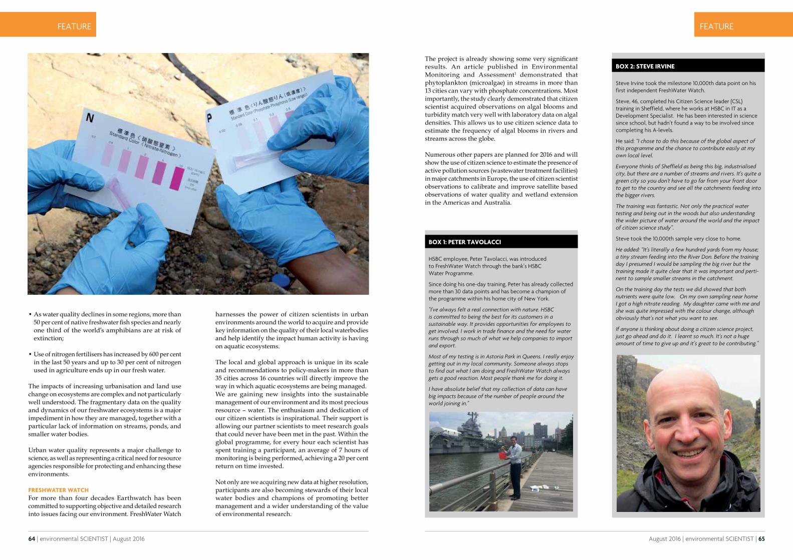
64 | environmental SCIENTIST | August 2016
CASE STUDY
August 2016 | environmental SCIENTIST | 65
FEATURE FEATURE
• As water quality declines in some regions, more than 50 per cent of native freshwater fish species and nearly one third of the world’s amphibians are at risk of extinction;
• Use of nitrogen fertilisers has increased by 600 per cent in the last 50 years and up to 30 per cent of nitrogen used in agriculture ends up in our fresh water.
The impacts of increasing urbanisation and land use change on ecosystems are complex and not particularly well understood. The fragmentary data on the quality and dynamics of our freshwater ecosystems is a major impediment in how they are managed, together with a particular lack of information on streams, ponds, and smaller water bodies.
Urban water quality represents a major challenge to science, as well as representing a critical need for resource agencies responsible for protecting and enhancing these environments.
FRESHWATER WATCHFor more than four decades Earthwatch has been committed to supporting objective and detailed research into issues facing our environment. FreshWater Watch
The project is already showing some very significant results. An article published in Environmental Monitoring and Assessment1 demonstrated that phytoplankton (microalgae) in streams in more than 13 cities can vary with phosphate concentrations. Most importantly, the study clearly demonstrated that citizen scientist acquired observations on algal blooms and turbidity match very well with laboratory data on algal densities. This allows us to use citizen science data to estimate the frequency of algal blooms in rivers and streams across the globe.
Numerous other papers are planned for 2016 and will show the use of citizen science to estimate the presence of active pollution sources (wastewater treatment facilities) in major catchments in Europe, the use of citizen scientist observations to calibrate and improve satellite based observations of water quality and wetland extension in the Americas and Australia.
harnesses the power of citizen scientists in urban environments around the world to acquire and provide key information on the quality of their local waterbodies and help identify the impact human activity is having on aquatic ecosystems.
The local and global approach is unique in its scale and recommendations to policy-makers in more than 35 cities across 16 countries will directly improve the way in which aquatic ecosystems are being managed.We are gaining new insights into the sustainable management of our environment and its most precious resource – water. The enthusiasm and dedication of our citizen scientists is inspirational. Their support is allowing our partner scientists to meet research goals that could never have been met in the past. Within the global programme, for every hour each scientist has spent training a participant, an average of 7 hours of monitoring is being performed, achieving a 20 per cent return on time invested.
Not only are we acquiring new data at higher resolution, participants are also becoming stewards of their local water bodies and champions of promoting better management and a wider understanding of the value of environmental research.
BOX 1: PETER TAVOLACCI
HSBC employee, Peter Tavolacci, was introduced to FreshWater Watch through the bank’s HSBC Water Programme.
Since doing his one-day training, Peter has already collected more than 30 data points and has become a champion of the programme within his home city of New York.
"I've always felt a real connection with nature. HSBC is committed to being the best for its customers in a sustainable way. It provides opportunities for employees to get involved. I work in trade finance and the need for water runs through so much of what we help companies to import and export.
Most of my testing is in Astoria Park in Queens. I really enjoy getting out in my local community. Someone always stops to find out what I am doing and FreshWater Watch always gets a good reaction. Most people thank me for doing it.
I have absolute belief that my collection of data can have big impacts because of the number of people around the world joining in."
BOX 2: STEVE IRVINE
Steve Irvine took the milestone 10,000th data point on his first independent FreshWater Watch.
Steve, 46, completed his Citizen Science leader (CSL) training in Sheffield, where he works at HSBC in IT as a Development Specialist. He has been interested in science since school, but hadn’t found a way to be involved since completing his A-levels.
He said: “I chose to do this because of the global aspect of this programme and the chance to contribute easily at my own local level.
Everyone thinks of Sheffield as being this big, industrialised city, but there are a number of streams and rivers. It's quite a green city so you don't have to go far from your front door to get to the country and see all the catchments feeding into the bigger rivers.
The training was fantastic. Not only the practical water testing and being out in the woods but also understanding the wider picture of water around the world and the impact of citizen science study”.
Steve took the 10,000th sample very close to home.
He added: “It's literally a few hundred yards from my house; a tiny stream feeding into the River Don. Before the training day I presumed I would be sampling the big river but the training made it quite clear that it was important and perti-nent to sample smaller streams in the catchment.
On the training day the tests we did showed that both nutrients were quite low. On my own sampling near home I got a high nitrate reading. My daughter came with me and she was quite impressed with the colour change, although obviously that’s not what you want to see.
If anyone is thinking about doing a citizen science project, just go ahead and do it. I learnt so much. It's not a huge amount of time to give up and it’s great to be contributing.”

August 2016 | environmental SCIENTIST | 6766 | environmental SCIENTIST | August 2016
CASE STUDYFEATURE
BOX 3: ESTHER COOMBES
Esther Coombes said that FreshWater Watch has also been a gateway for getting involved in a diverse range of projects near to her home.
Esther, an HSBC Claims Manager, found the FreshWater Watch Citizen Science Leader training day when she was browsing the HSBC Community Day opportunities. She said: “It sounded interesting. It appealed because I like being outdoors and walking so much, and I can do it locally but still be part of a large programme.”
Since completing her Citizen Science Leader training day, Esther has joined a community group taking care of her waterbody, the Friends of Brislington Brook. She has also trained in other citizen science programmes.
She added: “FreshWater Watch goes hand in hand with litter picks, Riverfly Monitoring and Himalayan Balsam Surveying. It’s really easy to fit it in together.
Without a doubt FreshWater Watch changed the way that I look at my local environment.
The area I test is a small brook in a valley and wooded area. I had lived in the area for 20 years and have taken my chil-dren down there for walks; there was an awful lot of rubbish – trolleys, tyres and the usual litter.
I join the Friends of Brislington Brook to do monthly litter picks and the place looks much better. It’s amazing the amount you pick. Now when I go there I’m looking for water colour, and the environment around it and I’m conscious of changes that are going on.”
Prof Steven Loiselle is the Global Freshwater Research Manager at Oxford-based Earthwatch. Steven has led several international research projects, resulting in more than 90 collaborative publications in leading scientific journals, presentations in international conferences and participation in scientific committees. He is a research professor at the University of Siena in Italy and visiting professor at the Chinese Academy of Sciences.
REFERENCES
1. Castilla, E.P., Cunha, D.G.F., Lee, F.W.F., Loiselle, S., Ho, K.H. and Hall, C. (2015) Quantification of phytoplankton bloom dynamics by citizen scientists in urban and peri-urban environments. Environmental Monitoring and Assessment, 187: 690. doi:10.1007/s10661-015-4912-9
Our citizen scientists are supporting local agencies to better manage these fundamental ecosystems. Across the globe, trained participants are providing important information to detect incidences of nutrient pollution, erosion events and algal blooms, information that allows local agencies to mitigate problems before they cascade into serious events.
The first tests were taken in and, in under four years, 15,000 data points have been taken by more than 8,000 citizen scientists who have sampled from 2,500 sites.
Drought Risk and You: engaging citizen scientists in drought researchEmma Weitkamp, Natasha Constant, Sarah Ayling and Lindsey McEwen discuss the benefits of engaging local communities with scientific research to combat drought and water shortage.
Droughts and water shortage pose a significant threat to the environment, agriculture, infrastructure, society and culture in the United
Kingdom (UK), affecting the lives of all of us and with climate change, droughts are predicted to become more frequent and severe. ”Drought Risk and You” (DRY)1 is a four year interdisciplinary project that is exploring ways to integrate knowledge of drought risk and water shortage in decision-making processes. The DRY project is using narrative/storytelling techniques to elicit knowledge and broker conversations with local community stakeholders. We are seeking to understand how local knowledge can be integrated
alongside scientific research to inform stakeholder decision-making. Within the citizen science activities, the research design encourages a two-way knowledge exchange; data collection feeds into risk modelling and upscaling, while narratives on personal relationships with water are captured. We are exploring (amongst other things), how we can involve citizens in research on monitoring drought impacts on ecology and the influences that this might have on their knowledge of drought, their relationship with the location, stewardship behaviour, and their engagement with, and interest in, environmental research.
CASE STUDY
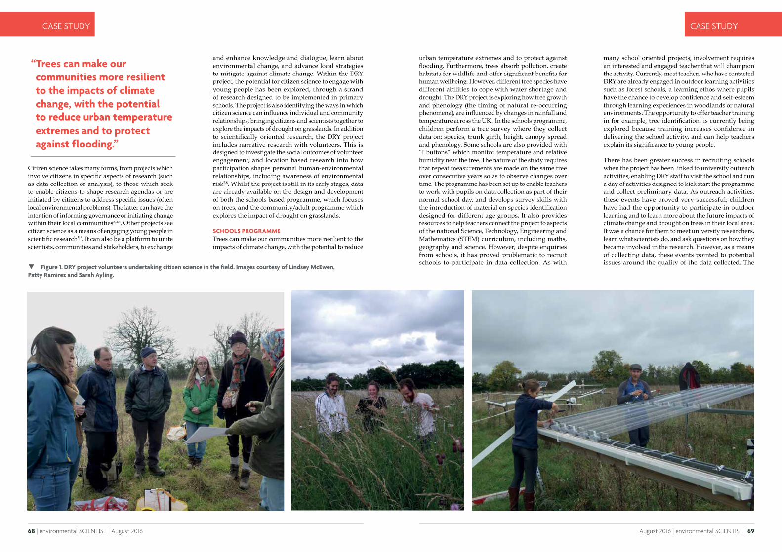
68 | environmental SCIENTIST | August 2016 August 2016 | environmental SCIENTIST | 69
CASE STUDY CASE STUDY
Citizen science takes many forms, from projects which involve citizens in specific aspects of research (such as data collection or analysis), to those which seek to enable citizens to shape research agendas or are initiated by citizens to address specific issues (often local environmental problems). The latter can have the intention of informing governance or initiating change within their local communities2,3,4. Other projects see citizen science as a means of engaging young people in scientific research5,6. It can also be a platform to unite scientists, communities and stakeholders, to exchange
and enhance knowledge and dialogue, learn about environmental change, and advance local strategies to mitigate against climate change. Within the DRY project, the potential for citizen science to engage with young people has been explored, through a strand of research designed to be implemented in primary schools. The project is also identifying the ways in which citizen science can influence individual and community relationships, bringing citizens and scientists together to explore the impacts of drought on grasslands. In addition to scientifically oriented research, the DRY project includes narrative research with volunteers. This is designed to investigate the social outcomes of volunteer engagement, and location based research into how participation shapes personal human-environmental relationships, including awareness of environmental risk7,8. Whilst the project is still in its early stages, data are already available on the design and development of both the schools based programme, which focuses on trees, and the community/adult programme which explores the impact of drought on grasslands.
SCHOOLS PROGRAMMETrees can make our communities more resilient to the impacts of climate change, with the potential to reduce
“ Trees can make our communities more resilient to the impacts of climate change, with the potential to reduce urban temperature extremes and to protect against flooding.”
urban temperature extremes and to protect against flooding. Furthermore, trees absorb pollution, create habitats for wildlife and offer significant benefits for human wellbeing. However, different tree species have different abilities to cope with water shortage and drought. The DRY project is exploring how tree growth and phenology (the timing of natural re-occurring phenomena), are influenced by changes in rainfall and temperature across the UK. In the schools programme, children perform a tree survey where they collect data on: species, trunk girth, height, canopy spread and phenology. Some schools are also provided with “I buttons” which monitor temperature and relative humidity near the tree. The nature of the study requires that repeat measurements are made on the same tree over consecutive years so as to observe changes over time. The programme has been set up to enable teachers to work with pupils on data collection as part of their normal school day, and develops survey skills with the introduction of material on species identification designed for different age groups. It also provides resources to help teachers connect the project to aspects of the national Science, Technology, Engineering and Mathematics (STEM) curriculum, including maths, geography and science. However, despite enquiries from schools, it has proved problematic to recruit schools to participate in data collection. As with
many school oriented projects, involvement requires an interested and engaged teacher that will champion the activity. Currently, most teachers who have contacted DRY are already engaged in outdoor learning activities such as forest schools, a learning ethos where pupils have the chance to develop confidence and self-esteem through learning experiences in woodlands or natural environments. The opportunity to offer teacher training in for example, tree identification, is currently being explored because training increases confidence in delivering the school activity, and can help teachers explain its significance to young people.
There has been greater success in recruiting schools when the project has been linked to university outreach activities, enabling DRY staff to visit the school and run a day of activities designed to kick start the programme and collect preliminary data. As outreach activities, these events have proved very successful; children have had the opportunity to participate in outdoor learning and to learn more about the future impacts of climate change and drought on trees in their local area. It was a chance for them to meet university researchers, learn what scientists do, and ask questions on how they became involved in the research. However, as a means of collecting data, these events pointed to potential issues around the quality of the data collected. The
Figure 1. DRY project volunteers undertaking citizen science in the field. Images courtesy of Lindsey McEwen, Patty Ramirez and Sarah Ayling.
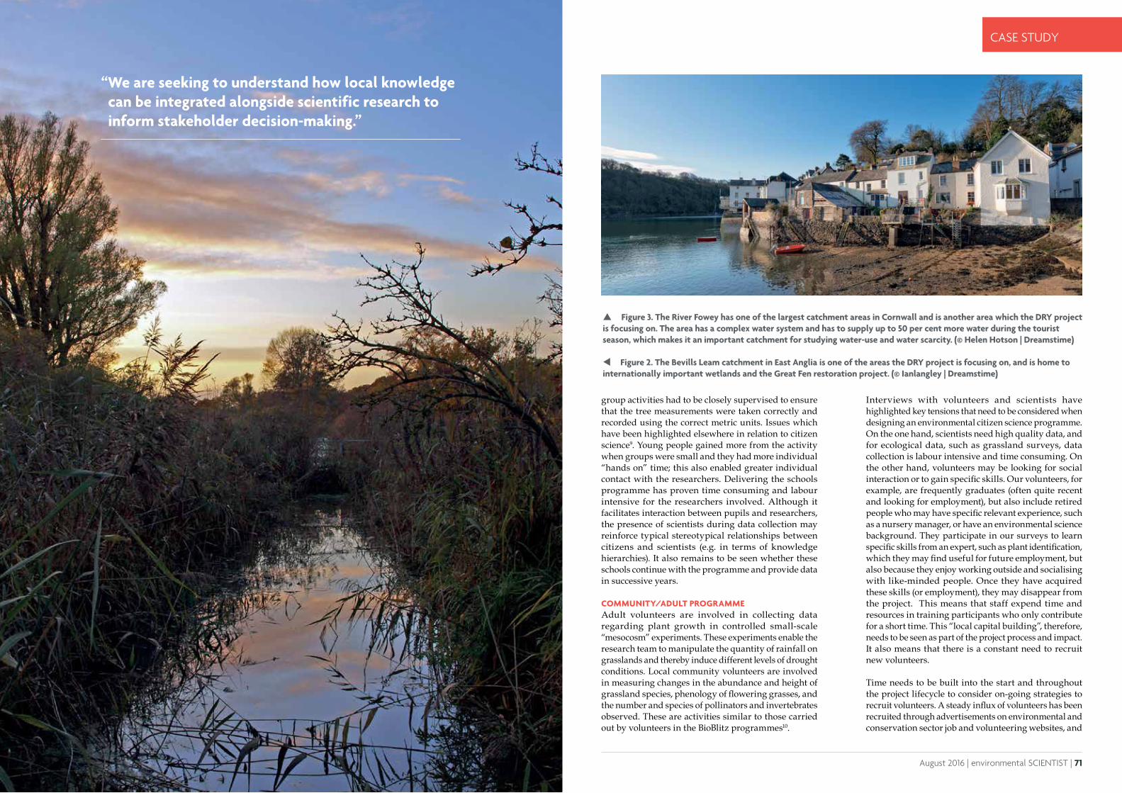
70 | environmental SCIENTIST | August 2016 August 2016 | environmental SCIENTIST | 71
CASE STUDY CASE STUDY
group activities had to be closely supervised to ensure that the tree measurements were taken correctly and recorded using the correct metric units. Issues which have been highlighted elsewhere in relation to citizen science9. Young people gained more from the activity when groups were small and they had more individual “hands on” time; this also enabled greater individual contact with the researchers. Delivering the schools programme has proven time consuming and labour intensive for the researchers involved. Although it facilitates interaction between pupils and researchers, the presence of scientists during data collection may reinforce typical stereotypical relationships between citizens and scientists (e.g. in terms of knowledge hierarchies). It also remains to be seen whether these schools continue with the programme and provide data in successive years.
COMMUNITY/ADULT PROGRAMMEAdult volunteers are involved in collecting data regarding plant growth in controlled small-scale “mesocosm” experiments. These experiments enable the research team to manipulate the quantity of rainfall on grasslands and thereby induce different levels of drought conditions. Local community volunteers are involved in measuring changes in the abundance and height of grassland species, phenology of flowering grasses, and the number and species of pollinators and invertebrates observed. These are activities similar to those carried out by volunteers in the BioBlitz programmes10.
Interviews with volunteers and scientists have highlighted key tensions that need to be considered when designing an environmental citizen science programme. On the one hand, scientists need high quality data, and for ecological data, such as grassland surveys, data collection is labour intensive and time consuming. On the other hand, volunteers may be looking for social interaction or to gain specific skills. Our volunteers, for example, are frequently graduates (often quite recent and looking for employment), but also include retired people who may have specific relevant experience, such as a nursery manager, or have an environmental science background. They participate in our surveys to learn specific skills from an expert, such as plant identification, which they may find useful for future employment, but also because they enjoy working outside and socialising with like-minded people. Once they have acquired these skills (or employment), they may disappear from the project. This means that staff expend time and resources in training participants who only contribute for a short time. This “local capital building”, therefore, needs to be seen as part of the project process and impact. It also means that there is a constant need to recruit new volunteers.
Time needs to be built into the start and throughout the project lifecycle to consider on-going strategies to recruit volunteers. A steady influx of volunteers has been recruited through advertisements on environmental and conservation sector job and volunteering websites, and
Figure 3. The River Fowey has one of the largest catchment areas in Cornwall and is another area which the DRY project is focusing on. The area has a complex water system and has to supply up to 50 per cent more water during the tourist season, which makes it an important catchment for studying water-use and water scarcity. (© Helen Hotson | Dreamstime)
Figure 2. The Bevills Leam catchment in East Anglia is one of the areas the DRY project is focusing on, and is home to internationally important wetlands and the Great Fen restoration project. (© Ianlangley | Dreamstime)
“ We are seeking to understand how local knowledge can be integrated alongside scientific research to inform stakeholder decision-making.”
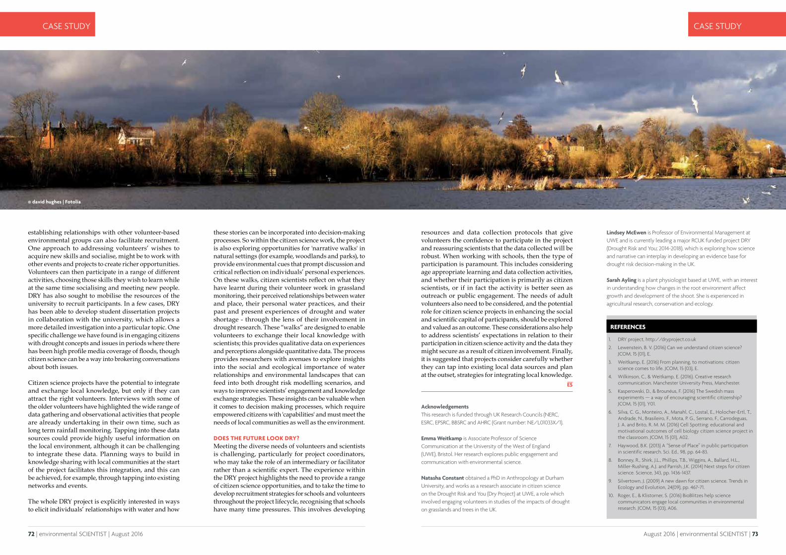
72 | environmental SCIENTIST | August 2016 August 2016 | environmental SCIENTIST | 73
CASE STUDY CASE STUDY
establishing relationships with other volunteer-based environmental groups can also facilitate recruitment. One approach to addressing volunteers’ wishes to acquire new skills and socialise, might be to work with other events and projects to create richer opportunities. Volunteers can then participate in a range of different activities, choosing those skills they wish to learn while at the same time socialising and meeting new people. DRY has also sought to mobilise the resources of the university to recruit participants. In a few cases, DRY has been able to develop student dissertation projects in collaboration with the university, which allows a more detailed investigation into a particular topic. One specific challenge we have found is in engaging citizens with drought concepts and issues in periods where there has been high profile media coverage of floods, though citizen science can be a way into brokering conversations about both issues.
Citizen science projects have the potential to integrate and exchange local knowledge, but only if they can attract the right volunteers. Interviews with some of the older volunteers have highlighted the wide range of data gathering and observational activities that people are already undertaking in their own time, such as long term rainfall monitoring. Tapping into these data sources could provide highly useful information on the local environment, although it can be challenging to integrate these data. Planning ways to build in knowledge sharing with local communities at the start of the project facilitates this integration, and this can be achieved, for example, through tapping into existing networks and events.
The whole DRY project is explicitly interested in ways to elicit individuals’ relationships with water and how
Acknowledgements This research is funded through UK Research Councils (NERC, ESRC, EPSRC, BBSRC and AHRC (Grant number: NE/L01033X/1).
Emma Weitkamp is Associate Professor of Science Communication at the University of the West of England (UWE), Bristol. Her research explores public engagement and communication with environmental science.
Natasha Constant obtained a PhD in Anthropology at Durham University, and works as a research associate in citizen science on the Drought Risk and You (Dry Project) at UWE, a role which involved engaging volunteers in studies of the impacts of drought on grasslands and trees in the UK.
REFERENCES
1. DRY project, http://dryproject.co.uk
2. Lewenstein, B. V. (2016) Can we understand citizen science? JCOM, 15 (01), E.
3. Weitkamp, E. (2016) From planning, to motivations: citizen science comes to life. JCOM, 15 (03), E.
4. Wilkinson, C., & Weitkamp, E. (2016). Creative research communication. Manchester University Press, Manchester.
5. Kasperowski, D., & Brounéus, F. (2016) The Swedish mass experiments — a way of encouraging scientific citizenship? JCOM, 15 (01), Y01.
6. Silva, C. G., Monteiro, A., Manahl, C., Lostal, E., Holocher-Ertl, T., Andrade, N., Brasileiro, F., Mota, P. G., Serrano, F., Carrodeguas, J. A. and Brito, R. M. M. (2016) Cell Spotting: educational and motivational outcomes of cell biology citizen science project in the classroom. JCOM, 15 (01), A02.
7. Haywood, B.K. (2013) A “Sense of Place” in public participation in scientific research. Sci. Ed., 98, pp. 64-83.
8. Bonney, R., Shirk, J.L., Phillips, T.B., Wiggins, A., Ballard, H.L., Miller-Rushing, A.J. and Parrish, J.K. (2014) Next steps for citizen science. Science, 343, pp. 1436-1437.
9. Silvertown, J. (2009) A new dawn for citizen science. Trends in Ecology and Evolution, 24(09), pp. 467-71.
10. Roger, E., & Klistorner, S. (2016) BioBlitzes help science communicators engage local communities in environmental research. JCOM, 15 (03), A06.
these stories can be incorporated into decision-making processes. So within the citizen science work, the project is also exploring opportunities for 'narrative walks' in natural settings (for example, woodlands and parks), to provide environmental cues that prompt discussion and critical reflection on individuals’ personal experiences. On these walks, citizen scientists reflect on what they have learnt during their volunteer work in grassland monitoring, their perceived relationships between water and place, their personal water practices, and their past and present experiences of drought and water shortage - through the lens of their involvement in drought research. These “walks” are designed to enable volunteers to exchange their local knowledge with scientists; this provides qualitative data on experiences and perceptions alongside quantitative data. The process provides researchers with avenues to explore insights into the social and ecological importance of water relationships and environmental landscapes that can feed into both drought risk modelling scenarios, and ways to improve scientists’ engagement and knowledge exchange strategies. These insights can be valuable when it comes to decision making processes, which require empowered citizens with 'capabilities' and must meet the needs of local communities as well as the environment.
DOES THE FUTURE LOOK DRY?Meeting the diverse needs of volunteers and scientists is challenging, particularly for project coordinators, who may take the role of an intermediary or facilitator rather than a scientific expert. The experience within the DRY project highlights the need to provide a range of citizen science opportunities, and to take the time to develop recruitment strategies for schools and volunteers throughout the project lifecycle, recognising that schools have many time pressures. This involves developing
resources and data collection protocols that give volunteers the confidence to participate in the project and reassuring scientists that the data collected will be robust. When working with schools, then the type of participation is paramount. This includes considering age appropriate learning and data collection activities, and whether their participation is primarily as citizen scientists, or if in fact the activity is better seen as outreach or public engagement. The needs of adult volunteers also need to be considered, and the potential role for citizen science projects in enhancing the social and scientific capital of participants, should be explored and valued as an outcome. These considerations also help to address scientists’ expectations in relation to their participation in citizen science activity and the data they might secure as a result of citizen involvement. Finally, it is suggested that projects consider carefully whether they can tap into existing local data sources and plan at the outset, strategies for integrating local knowledge.
Lindsey McEwen is Professor of Environmental Management at UWE and is currently leading a major RCUK funded project DRY (Drought Risk and You; 2014-2018), which is exploring how science and narrative can interplay in developing an evidence base for drought risk decision-making in the UK.
Sarah Ayling is a plant physiologist based at UWE, with an interest in understanding how changes in the root environment affect growth and development of the shoot. She is experienced in agricultural research, conservation and ecology.
© david hughes | Fotolia
74 | environmental SCIENTIST | August 2016 August 2016 | environmental SCIENTIST | 75
ANALYSIS ANALYSIS
Data quality in citizen science – a research studyYolanda Wiersma, Jeffrey Parsons and Roman Lukyanenko discuss the findings of their research into how data quality can be improved for participants of citizen science.
Their leader (who in his day job is a chemistry professor at the local university) takes the samples into work the next day, where he hands them to a colleague who is studying urban water quality.
That evening a teen with ambitions to be a wildlife biologist finishes her homework and logs on to her computer. Rather than killing time watching YouTube videos, she navigates to the “Snapshot Serengeti” website1 and spends the evening identifying photos of wildebeest, gazelles and other large African mammals.
THE BENEFITS OF CITIZEN SCIENCEThe above scenarios are all examples of 'citizen science', and the birdwatcher, Boy Scouts and teen are all 'citizen scientists'. Citizen science can involve lay people participating in many types of research projects, including medicine, environmental science, astronomy, geology, biochemistry, ecology and earth science, and has many benefits. These include educating and engaging the public on scientific issues, as well as the generation of large data sets for scientific work. Citizen science projects vary in terms of the tasks they ask the public to complete, but most projects involve citizens collecting, processing or analysing data.
Citizen science seems like a natural win-win for all involved – citizens get the fun and learning experience by being engaged with science and scientists get the free labour. However, some people question whether lay people can actually contribute meaningfully to science. A concern frequently expressed is the quality of the data. This is particularly true when all or part of the citizen science project is online (e.g., eBird and Snapshot Serengeti), as participants may be anonymous and the risk of sabotage is higher than when scientists are in direct contact with citizen participants.
Thus, there is a need for research on the process of doing citizen science, as well as on the dimensions that affect its success; this includes motivation, types of participation and data quality. The interdisciplinary group – an ecologist working with two information system scientists – have been conducting research on the latter topic. Data quality is usually assumed to mean accuracy, but can have over 100 different dimensions2 including precision, timeliness, completeness and believability. This research has focused on accuracy, completeness and, to a lesser extent, fitness-for-use.
“ A concern frequently expressed is the quality of the data.”
On a bright spring day, a lifelong birdwatcher travels to her favourite green space and spends the day observing spring migrants, taking notes
of the species she observes and their abundance. When she gets home, she logs into eBird.org and enters her sightings into a database that already contains millions of records from around the world.
On the same day, a group of Boy Scouts hikes along an urban river. Under the supervision of their leader, they meticulously collect water samples from different points. They note where the samples come from on labels and take data on the time of day and the water temperature.
© zlikovec | Fotolia
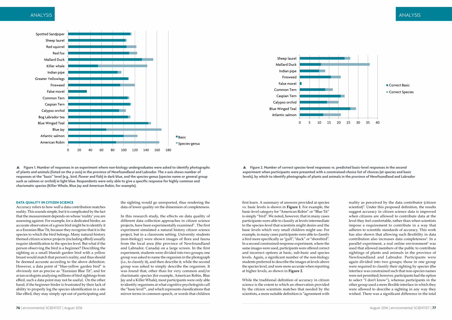
76 | environmental SCIENTIST | August 2016 August 2016 | environmental SCIENTIST | 77
ANALYSIS ANALYSIS
DATA QUALITY IN CITIZEN SCIENCEAccuracy refers to how well a data contribution matches reality. This sounds simple, but it is complicated by the fact that the measurement depends on whose 'reality' you are assessing against. For example, for a dedicated birder, an accurate observation of a given bird might be to identify it as a Eurasian Blue Tit, because they recognise that it is the species to which the bird belongs. Many natural-history themed citizen science projects (including eBird) usually require identification to the species level. But what if the person observing the bird is a beginner? Describing the sighting as a small blueish garden bird with a yellow breast would match that person’s reality, and thus should be deemed accurate according to the above definition. However, a data point of “blue-yellow garden bird” is obviously not as precise as “Eurasian Blue Tit”, and for avian ecologists analysing millions of bird sightings from eBird, such a data point may not be useful. On the other hand, if the beginner birder is frustrated by their lack of ability to properly log the species identification in a site like eBird, they may simply opt out of participating and
the sighting would go unreported, thus rendering the data of lower quality on the dimension of completeness.
In this research study, the effects on data quality of different data collection approaches in citizen science projects, have been experimentally examined3 . The first experiment simulated a natural history citizen science project, but in a classroom setting. University students (non-biology) were shown images of flora and fauna from the local area (the province of Newfoundland and Labrador, Canada) on a large screen. In the first experiment, students were divided into two groups; one group was asked to name the organism in the photograph (i.e., to classify it), and then describe it, while the second group was asked to simply describe the organism. It was found that, other than for very common and/or charismatic species (for example, American Robin, Blue Jay and a Killer Whale), most participants were only able to identify organisms at what cognitive psychologists call the “basic level”4 , and which represents classifications that mirror terms in common speech, or words that children
first learn. A summary of answers provided at species vs. basic levels is shown in Figure 1. For example, the basic-level category for “American Robin” or “Blue Tit” is simply “bird”. We noted, however, that in many cases participants were able to classify at levels intermediate to the species-level that scientists might desire and the basic levels which very small children might use. For example, in many cases participants were able to classify a bird more specifically as “gull”, “duck” or “shorebird”. In a second constrained-response experiment, where the same images were used, participants were offered correct and incorrect options at basic, sub-basic and species levels. Again, a significant number of the non-biology students preferred to describe the images at levels above the species level, and were more accurate when reporting at higher levels, as shown in Figure 2.
While the traditional definition of accuracy in citizen science is the extent to which an observation provided by the citizen scientists matches that needed by the scientists, a more suitable definition is “agreement with
Figure 2. Number of correct species-level responses vs. predicted basic-level responses in the second experiment when participants were presented with a constrained-choice list of choices (at species and basic levels), by which to identify photographs of plants and animals in the province of Newfoundland and Labrador
Figure 1. Number of responses in an experiment where non-biology undergraduates were asked to identify photographs of plants and animals (listed on the y-axis) in the province of Newfoundland and Labrador. The x-axis shows number of responses at the “basic” level (e.g., bird, flower and fish) in dark blue, and the species-genus (species name or general group such as salmon or orchid) in light blue. Respondents were only able to give a specific response for highly common and charismatic species (Killer Whale, Blue Jay and American Robin, for example).
0 20 40 60 80 100 120 140 160 180
Basic
Species-genusAmerican Robin
Atlantic salmon
748*"9.:"Blue Jay
Blue Winged Teal
Bog Labrador tea
Calypso orchid
Caspian Tern
Common Tern
False morel
C,+*D**="Fireweed
Greater Yellowlegs
Killer whale
Indian pipe
Mallard Duck
0*="L1M"Red squirrel
Red fox
Sheep laurel
Spotted Sandpiper
0 5 10 15 20 25 30 35 40
Atlantic salmon
Blue Winged Teal
Calypso orchid
Caspian Tern
Common Tern
False morel
Fireweed
Indian pipe
Mallard Duck
Sheep laurel
Correct Basic
Correct Species
reality as perceived by the data contributor (citizen scientist)”. Under this proposed definition, the results suggest accuracy in citizen science data is improved when citizens are allowed to contribute data at the level they feel comfortable, rather than when scientists impose a requirement to contribute in a way that adheres to scientific standards of accuracy. This work has also shown that allowing such flexibility in data contribution also increases data completeness5. In a parallel experiment, a real online environment6 was used that allowed members of the public to contribute sightings of plants and animals in the province of Newfoundland and Labrador. Participants were again divided into two groups; those in one group were required to classify their sighting by species (the interface was constrained such that non-species names were not permitted; however, participants had the option to select “I don’t know”), whereas participants in the other group used a more flexible interface in which they were allowed to describe a sighting in any way they wished. There was a significant difference in the total
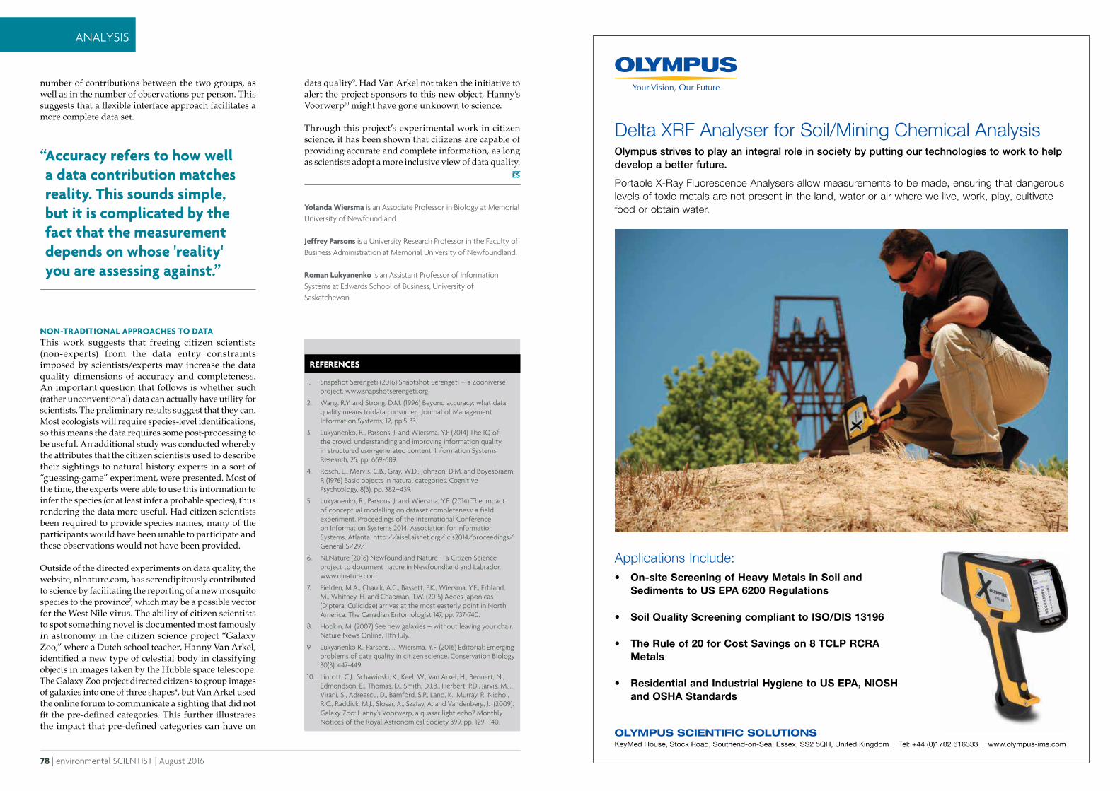
78 | environmental SCIENTIST | August 2016
ANALYSIS
Delta XRF Analyser for Soil/Mining Chemical Analysis Olympus strives to play an integral role in society by putting our technologies to work to help develop a better future.
Portable X-Ray Fluorescence Analysers allow measurements to be made, ensuring that dangerous levels of toxic metals are not present in the land, water or air where we live, work, play, cultivate food or obtain water.
OLYMPUS SCIENTIFIC SOLUTIONSKeyMed House, Stock Road, Southend-on-Sea, Essex, SS2 5QH, United Kingdom | Tel: +44 (0)1702 616333 | www.olympus-ims.com
Applications Include:• On-site Screening of Heavy Metals in Soil and
Sediments to US EPA 6200 Regulations
• Soil Quality Screening compliant to ISO/DIS 13196
• The Rule of 20 for Cost Savings on 8 TCLP RCRA Metals
• Residential and Industrial Hygiene to US EPA, NIOSH and OSHA Standards
21310 Olympus Delta Environmental.indd 1 09/06/2016 16:41
Yolanda Wiersma is an Associate Professor in Biology at Memorial University of Newfoundland.
Jeffrey Parsons is a University Research Professor in the Faculty of Business Administration at Memorial University of Newfoundland.
Roman Lukyanenko is an Assistant Professor of Information Systems at Edwards School of Business, University of Saskatchewan.
REFERENCES
1. Snapshot Serengeti (2016) Snaptshot Serengeti – a Zooniverse project. www.snapshotserengeti.org
2. Wang, R.Y. and Strong, D.M. (1996) Beyond accuracy: what data quality means to data consumer. Journal of Management Information Systems, 12, pp.5-33.
3. Lukyanenko, R., Parsons, J. and Wiersma, Y.F (2014) The IQ of the crowd: understanding and improving information quality in structured user-generated content. Information Systems Research, 25, pp. 669-689.
4. Rosch, E., Mervis, C.B., Gray, W.D., Johnson, D.M. and Boyesbraem, P. (1976) Basic objects in natural categories. Cognitive Psychcology, 8(3), pp. 382–439.
5. Lukyanenko, R., Parsons, J. and Wiersma, Y.F. (2014) The impact of conceptual modelling on dataset completeness: a field experiment. Proceedings of the International Conference on Information Systems 2014. Association for Information Systems, Atlanta. http://aisel.aisnet.org/icis2014/proceedings/GeneralIS/29/
6. NLNature (2016) Newfoundland Nature – a Citizen Science project to document nature in Newfoundland and Labrador, www.nlnature.com
7. Fielden, M.A., Chaulk, A.C., Bassett, P.K., Wiersma, Y.F., Erbland, M., Whitney, H. and Chapman, T.W. (2015) Aedes japonicas (Diptera: Culicidae) arrives at the most easterly point in North America. The Canadian Entomologist 147, pp. 737-740.
8. Hopkin, M. (2007) See new galaxies – without leaving your chair. Nature News Online, 11th July.
9. Lukyanenko R., Parsons, J., Wiersma, Y.F. (2016) Editorial: Emerging problems of data quality in citizen science. Conservation Biology 30(3): 447-449.
10. Lintott, C.J., Schawinski, K., Keel, W., Van Arkel, H., Bennert, N., Edmondson, E., Thomas, D., Smith, D.J.B., Herbert, P.D., Jarvis, M.J., Virani, S., Adreescu, D., Bamford, S.P., Land, K., Murray, P., Nichol, R.C., Raddick, M.J., Slosar, A., Szalay, A. and Vandenberg, J. (2009). Galaxy Zoo: Hanny’s Voorwerp, a quasar light echo? Monthly Notices of the Royal Astronomical Society 399, pp. 129–140.
number of contributions between the two groups, as well as in the number of observations per person. This suggests that a flexible interface approach facilitates a more complete data set.
NON-TRADITIONAL APPROACHES TO DATAThis work suggests that freeing citizen scientists (non-experts) from the data entry constraints imposed by scientists/experts may increase the data quality dimensions of accuracy and completeness. An important question that follows is whether such (rather unconventional) data can actually have utility for scientists. The preliminary results suggest that they can. Most ecologists will require species-level identifications, so this means the data requires some post-processing to be useful. An additional study was conducted whereby the attributes that the citizen scientists used to describe their sightings to natural history experts in a sort of “guessing-game” experiment, were presented. Most of the time, the experts were able to use this information to infer the species (or at least infer a probable species), thus rendering the data more useful. Had citizen scientists been required to provide species names, many of the participants would have been unable to participate and these observations would not have been provided.
Outside of the directed experiments on data quality, the website, nlnature.com, has serendipitously contributed to science by facilitating the reporting of a new mosquito species to the province7, which may be a possible vector for the West Nile virus. The ability of citizen scientists to spot something novel is documented most famously in astronomy in the citizen science project “Galaxy Zoo,” where a Dutch school teacher, Hanny Van Arkel, identified a new type of celestial body in classifying objects in images taken by the Hubble space telescope. The Galaxy Zoo project directed citizens to group images of galaxies into one of three shapes8, but Van Arkel used the online forum to communicate a sighting that did not fit the pre-defined categories. This further illustrates the impact that pre-defined categories can have on
data quality9. Had Van Arkel not taken the initiative to alert the project sponsors to this new object, Hanny’s Voorwerp10 might have gone unknown to science.
Through this project’s experimental work in citizen science, it has been shown that citizens are capable of providing accurate and complete information, as long as scientists adopt a more inclusive view of data quality.“ Accuracy refers to how well
a data contribution matches reality. This sounds simple, but it is complicated by the fact that the measurement depends on whose 'reality' you are assessing against.”