the rise of pirata - brest.ird.fr 1995-2005.pdf · implementation panel in fortaleza, ceará,...
TRANSCRIPT

The Rise of PIRATA1995-2005
An informal history of the first ten years of the Pilot Research Moored
Array in the Tropical Atlantic
Jacques Servain Antonio Divino Moura and Michael J. McPhaden

Cover photo: The participants at the PIRATA-3 Meeting which was held at PMEL in Seattle, Washington, USA in March 1997. Kneeling: Marcio Vianna. Front row (left to right): Ping Chang, Sylvia Garzoli, Jacques Servain. Back row (left to right): Tony Busalacchi, Jim Carton, Divino Moura, Mike McPhaden. Back row: Unknown, Alaor D’all Antonia Jr. Photo credit: unknown.

1
Table of ConTenTS
Introduction . . . . . . . . . . . . . . . . . . . . . . . . . . . . . . . . . . . . . . . . . . . . 3
from Tao to PIRaTa (1994-1995) . . . . . . . . . . . . . . . . . . . . . . . . . . . . . . . . . . . . . . . . . 5
The first PIRATA Meetings (1996-2001) . . . . . . . . . . . . . . . . . . . . . . . . . . . . . . . . . . . . . . . . . 8
The first ATLAS launchings by France and Brazil (1997-2000) . . . . . . . . . . . . . . . . . . . . . . . . . . . . . . . . . . . . . . . . 16
How the name of PIRATA was chosen . . . . . . . . . . . . . . . . . . . . 21
The symbolism of the PIRATA logo . . . . . . . . . . . . . . . . . . . . . . 23
The PIRATA musical buoys . . . . . . . . . . . . . . . . . . . . . . . . . . . . . . 26
Tuna fishing, vandalism and repulsion device . . . . . . . . . . . . . 28
The noR-50 . . . . . . . . . . . . . . . . . . . . . . . . . . . . . . . . . . . . . . . . . . 34
The three phases of PIRATA, the PRB and the MoU . . . . . . . . 36
PIRATA in the media . . . . . . . . . . . . . . . . . . . . . . . . . . . . . . . . . . . 39
PIRATA’s boutique . . . . . . . . . . . . . . . . . . . . . . . . . . . . . . . . . . . . . 42
Photo gallery . . . . . . . . . . . . . . . . . . . . . . . . . . . . . . . . . . . . . . . . . 43
Acknowledgements . . . . . . . . . . . . . . . . . . . . . . . . . . . . . . . . . . . . 44
List of references . . . . . . . . . . . . . . . . . . . . . . . . . . . . . . . . . . . . . . 45
Press references . . . . . . . . . . . . . . . . . . . . . . . . . . . . . . . . . . . . . . . 45
Appendix 1: PRB and PIRATA-SSC (1995-2005) . . . . . . . . . . . . . 46
Appendix 2: PIRATA Meetings (1995-2006) . . . . . . . . . . . . . . . . 48

2
Figure 1: Present status (June 2018) of the PIRATA Network, with associated other measurements.
PIRATA
20°N
10°N
0°
10°S
20°S
60°W 40°W 20°W 0° 20°E
Standard ATLAS
Northeast Extension
Meteo France BP
New T-Flex systems
Flux Reference Site
Southeast Extension
O2 Enhanced ATLAS
New EU-Preface ADCP
ADCP
Southwest Extension
CO2/O2 Enhanced ATLAS
Pirata-FR ADCP

3
InTRodUcTIon
The World Climate Research Program (WCRP) was established in 1980 and jointly sponsored by the International Council for Science (ICSU), the World Meteorological Organization (WMO) and, from 1993, the Intergovernmental Oceanographic Commission (ICSU) of UNESCO (see https://www.wcrp-climate.org/about-wcrp/about-history). The main objectives of WCRP, defined at its inception, are to determine the predictability of climate and the effect of human activities on climate.
Under the auspices of the WCRP, a 10-year (1985-1994) international climate research program effort, called The Tropical Ocean Global Atmosphere (TOGA), was carried out, the goals of which were to determine the predictability of the coupled ocean-atmosphere system in the tropics on seasonal-to-interannual time scales, to understand the mechanisms responsible for that predictability, and to establish an observing system to support climate prediction (http://tos.org/oceanography/article/a-toga-retrospective ).
TOGA program focused much of its resources the Pacific Ocean to better observe, understand and predict El Niño and the Southern Oscillation (ENSO). ENSO is the strongest year-to-year fluctuation of the climate system on the planet, with impacts felt around the world. It is understandable therefore that so much effort was devoted to the Pacific during TOGA, but it left the Tropical Atlantic and the Indian Ocean underdeveloped.However, given the tremendous regional impacts that Atlantic Ocean surface temperature fluctuations imprint on the seasonal climate of the bordering continents of South America, particularly Northeast Brazil, and tropical areas of Africa, there was clearly need for a major ocean and climate research initiative in the tropical Atlantic.
Pilot Research Mooring Array in the Tropical Atlantic (PIRATA) was thus born as a necessity to gather ocean-atmospheric data for research and climate prediction. The TOGA buoy technology was proven and the ability to implement and sustain a basin scale moored array had been demonstrated in the Pacific by NOAA´s Pacific Environmental Laboratory and its partners. So, we took advantage of this technology and experience to build PIRATA in the Atlantic.
Since its inception more than 20 years ago, PIRATA (now named “Permanent Research Moored Array in the Tropical Atlantic”) has greatly advanced our understanding the tropical Atlantic climate variability and
4
its impact on surrounding regions. The PIRATA bibliography of refereed journal publication (http://www.aoml.noaa.gov/phod/pne/index.php) contains nearly 300 articles spanning a wide variety of topics related to ocean dynamics, ocean-atmosphere interactions, and the role in the climate system. PIRATA has also contributed to the development of seasonal forecast models and provided data in real-time for weather, climate, and ocean forecast model initialization (Bourlès et al., 2008). PIRATA data are incorporated into many oceanic and atmospheric data bases and provide key constraint on nearly all oceanic and atmospheric reanalyses that include the tropical Atlantic. Ships that regularly service PIRATA offer deployment opportunities for Argo floats and drifting buoys, helping to build and maintain these and other elements of the Global Ocean Observing System (GOOS). The shipboard measurements routinely collected on PIRATA cruises themselves constitute valuable climate records not obtainable through any other means.
The purpose of this article is to describe the process by which PIRATA was developed from the personal perspectives of three principal players. The emphasis is more on the group dynamics, challenges, and coordination by which PIRATA was implemented rather than the specific scientific advances that PIRATA enabled. For more scientific and technical accounts of PIRATA’s origins, the reader is referred to Servain et al. (1998) and Bourlès et al. (2008).

5
FRoM TAo To PIRATA (1994-1995)
At the third session of the TAO Implementation Panel (TIP-3) Meeting which held in 1994 at Seoul, South Korea, Michael McPhaden, Chairman of the TIP, reported that “Instituto Nacional de Pesquisas Espaciais” (INPE) and “Fundação Cearense de Meteorologia e Recursos Hidricos” (FUNCEME) in Brazil had offered to sponsor the 1995 meeting of the TAO Implementation Panel in Fortaleza, Ceará, Brazil. An Atlantic venue for the next meeting could stimulate discussion of possible future expansions of TAO into the tropical Atlantic as part of CLIVAR/GOALS and NOAA’s Pan
Figure 2: In situ components of the TOGA Observing System at the end of the Program in December 1994. Symbols denote the different measurement technologies used. One orange arrow represents 10 drifting buoys. Note how underdeveloped the Atlantic and Indian Oceans were relative to the Pacific at the end of TOGA.
TOGA In Situ Ocean Observing System Global Tropics
December 1994
December 1994
Moored buoys
Tide gage stations
Satellite data relay
Drifting buoys
Volunteer observing
ships

6
American Climate Studies (PACS) program. In light of the mid-October GCOS meeting, the 4th Meeting of the TAO Implementation Panel was planned for September 1995.
At the opening of TIP-4 at Fortaleza (12-14 September 1995), Antonio Divino Moura of INPE expressed the desire that this first meeting of the TAO Implementation Panel in the Atlantic sector would encourage an extension of TAO-type measurements into the region. He went on to say that the Science and Technology Ministry in Brazil has shown interest in these types of measurements, and that TIP-4 represented an excellent opportunity to make progress in developing an appropriate measurement program.
During the TIP-4 Meeting, Jacques Servain of “Université de Bretagne Occidentale / Office de Recherche Scientifique et Technique Outre Mer” UBO/ORSTOM (now IRD) reviewed the scientific issues regarding ocean-atmosphere variability in the tropical Atlantic on time scales of relevance to seasonal, interannual and longer-term climate. Two significant modes of climate variability, namely the north-south Atlantic “dipole” and an ENSO-like mode with manifestations mainly along the equatorial region, were the principal topics of discussion. These modes have a clear impact on the regional climate of the Atlantic basin, especially over the two adjacent continental regions. Therefore, there is compelling reason to better understand their origins and evolution, and to better define the limits of their predictability. The TAO Implementation Panel recognized that present in situ data bases are inadequate to address many of the outstanding issues related to these climate signals. Hence, it recommended that consideration be given to pilot studies designed to enhance the climate data base in the tropical Atlantic. It furthermore noted that a pilot scale moored measurement program, appropriately designed, could provide high accuracy time series data capable of addressing some of the unanswered questions about ocean-atmosphere interactions in this part of the world ocean.
Subsequent to the Fortaleza meeting, a Scientific Steering Committee (SSC), composed of Brazilian, French and US researchers was formed to draft a scientific prospectus and implementation plan for a pilot moored array in the tropical Atlantic. The committee was co-chaired by Antonio Divino Moura (INPE, Brazil) and Jacques Servain (UBO/ORSTOM, now IRD, France). The other members of this first international SSC were Mike McPhaden (NOAA/PMEL, USA), Tony Busalacchi (NASA/GSFC, USA), Steve Zebiak (LDEO/IRI, USA), Marcio Vianna (INPE, Brazil) and Gilles Reverdin (CNRS, France). After some exchanges by emails it was decided that the name PIRATA, for PIlot Research moored Array in the Tropical Atlantic (see § 5) was appropriate for the pilot project.
7
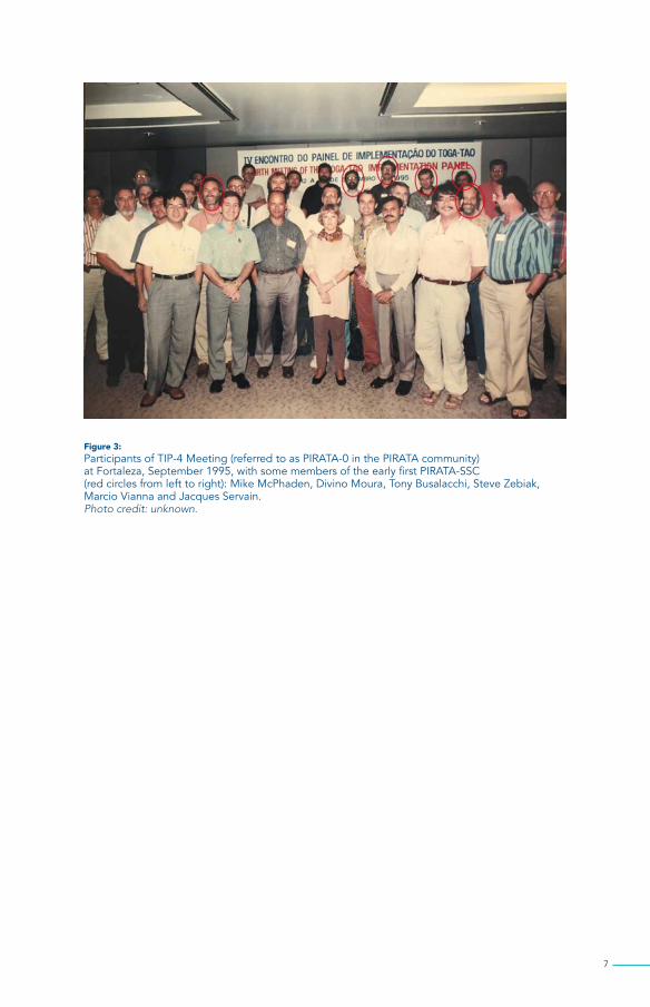
Figure 3: Participants of TIP-4 Meeting (referred to as PIRATA-0 in the PIRATA community) at Fortaleza, September 1995, with some members of the early first PIRATA-SSC (red circles from left to right): Mike McPhaden, Divino Moura, Tony Busalacchi, Steve Zebiak, Marcio Vianna and Jacques Servain. Photo credit: unknown.
8
THe FIRST PIRATA MeeTIngS (1996-2001)
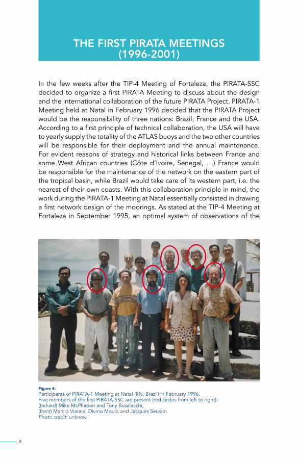
In the few weeks after the TIP-4 Meeting of Fortaleza, the PIRATA-SSC decided to organize a first PIRATA Meeting to discuss about the design and the international collaboration of the future PIRATA Project. PIRATA-1 Meeting held at Natal in February 1996 decided that the PIRATA Project would be the responsibility of three nations: Brazil, France and the USA. According to a first principle of technical collaboration, the USA will have to yearly supply the totality of the ATLAS buoys and the two other countries will be responsible for their deployment and the annual maintenance. For evident reasons of strategy and historical links between France and some West African countries (Côte d’Ivoire, Senegal, …) France would be responsible for the maintenance of the network on the eastern part of the tropical basin, while Brazil would take care of its western part, i.e. the nearest of their own coasts. With this collaboration principle in mind, the work during the PIRATA-1 Meeting at Natal essentially consisted in drawing a first network design of the moorings. As stated at the TIP-4 Meeting at Fortaleza in September 1995, an optimal system of observations of the
Figure 4: Participants of PIRATA-1 Meeting at Natal (RN, Brazil) in February 1996. Five members of the first PIRATA-SSC are present (red circles from left to right): (behind) Mike McPhaden and Tony Busalacchi, (front) Marcio Vianna, Divino Moura and Jacques Servain. Photo credit: unknow.

9
weather-ocean conditions in the tropical Atlantic had to take into account both the mode of variability along the equatorial as well as the dipole mode across the equator.
Figure 5:The above and following documents originate from the PIRATA-1 Meeting at Natal (CE, Brazil). The handwritten document, kept by Mike McPhaden, is a very rough draft of the implementation calculations for a proposal to NOAA to support PIRATA as a pilot for three years: 1997-2000. We would start with two moorings in September 1997 (upper left corner of table), have the full array in place by August 2000 (right column, fifth entry) and then recover the entire array after one year in August 2000 (second last line of table) on the assumption that the program would end. We estimated we needed 20 mooring systems to maintain an array of 12 moorings. This was less than the normal assumption of 2 x systems for each site since we assumed that recovered systems would be returned to PMEL quick enough to turn them around for the next cruise.

10
The budget requested to NOAA (very top of page) was US$ 150K in US fiscal year 1997 (October 1996-September 1997) and US$ 2 million maximum over the three years. That was the initial plan. It was delayed because our assumption that NOAA would provide US$150K US in the first year did not materialize. Instead only US$ 75K was provided. We had to scramble as a result, but still made it work since Brazil and France came to the rescue. Of course, we did not pull the array out of the water in August 2000!
PIRATA - Tentativa Plan for Buoy Deployments
8/97
5(+1)
5
0(+1)
5(+1)
BR 40FR 15
8/00
0
0
19(+4)
19(+4)
BR 45(FR 20)
2/00
0
14
5(+4)
19(+4)
BR 45(FR 20)
8/99
9(+2)
14
5(+2)
19(+4)
BR 45(FR 20)
2/99
0
10
(2)
10(+2)
BR 45(FR 20)
8/98
5(+1)
5
5(+2)
10(+2)
BR 40FR 15
Date
Buoysto buy
In Water
In Lab
Inventory
Ship Days(?≈)
1 year 6m 6m 6m 6m
FR buys 5 (+1) buyos (3 in 6/97; 3 in 6/98)BR buys 5 (+1) buyos (3 in 6/97; 3 in 6/98)US buys 9 (+2) buyos (11 in 6/99)
5
5
5 5
5
5
5
5 5 14
95
Figure 6: The second document (just above - kept by Divino Moura) is a calendar diagram of the deployment of the mooring systems during the 3-year pilot phase of PIRATA.
One of the first responsibilities of the early PIRATA-SSC was to write a “Terms of Reference” (see below) intended for the main scientific institutions of the three partner nations to support the implementation of a 3-year pilot moored array in the tropical Atlantic. These institutions were INPE for Brazil, ORSTOM (now IRD) for France, and the NOAA for USA. The objective was to extend in this ocean the TAO array which had been successfully deployed for climate studies in the Pacific during the TOGA Program (1985-1994). The idea was that such program would address the general call for further development of the tropical Atlantic Ocean observing system under auspices of the international CLIVAR project launched in 1995.

11
In August 1996, the second PIRATA Meeting held at Brest, France. The main objective of PIRATA-2 Meeting was to prepare a first draft of a white paper to define the scientific focus of the PIRATA program. This plan provided the framework for requesting resources in the form of funding, ship time and technical staff to initiate the Program. Leading the charge in Brazil were Divino Moura (INPE) and Janice Trotte (DHN), in France, Jacques Servain (ORSTOM), and in the USA Mike McPhaden (NOAA).
Figure 7:The Terms of Reference of PIRATA written during the first PIRATA International Meeting (PIRATA-1) at Natal, RN, Brazil in February 1996. This is the very first official document for the creation of the PIRATA Program.

12
Figure 8: Facsimilé of email sent by Jacques Servain (“Oncle Jacques”) to the participants of the second PIRATA Meeting which held in Brest, France, in August 1996.
13
By prior agreement, the responsibility for purchasing ATLAS mooring systems were shared by Brazil (5 systems), France (5 systems) and the USA (10 systems). All moorings during the pilot study are built by PMEL, which is also responsible for shipping, calibration, laboratory checkouts, instrument refurbishment’s. Logistic support in terms of ship-time for developing and maintaining the PIRATA moored array are mainly the responsibility of Brazil and France.
Due to the delayed financial part of the NOAA, the first ATLAS moorings launched by France were financed by ORSTOM (2 buoys) and by Météo-France (1 buoy), while the first Brazilian moorings were financed by the Brazilian Ministry of Science and Technology (MCT). Also, extremely important was the support by the Brazilian Navy, after a successful presentation by Divino Moura to the Minister Maximiliano da Fonseca, of the importance of an Atlantic monitoring to provide data for drought prediction for the Brazilian Nordeste. The Minister understood the importance of the proposal and approved the Navy support in terms of ship time, yet to be determined. Also important was the support of the Brazilian Ministry of Science, through one of its directors (José de Anchieta Moura Fé) in providing about US$ 600,000.00 to acquire the first buoys to be launched (and spare) in the western region.
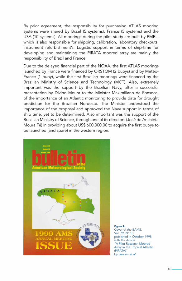
Figure 9: Cover of the BAMS, Vol. 79, N° 10, published in October 1998 with the Article “A Pilot Research Moored Array in the Tropical Atlantic (PIRATA)” by Servain et al.
14
The two subsequent meetings, PIRATA-3 at Seattle, WA, USA, in March 1997, and PIRATA-4 at Rio de Janeiro, RJ, Brazil, in November 1997 were important to continue the discussion concerning PIRATA logistics and implementation issues.
The PIRATA-5 Meeting was jointly held with the TIP-7 Meeting in November 1998 at Abidjan, Côte d’Ivoire. This was an opportunity to strengthen the collaboration between the PIRATA and TAO communities and the other climate research and operational programs which were currently being developed over the African region focusing on the oceanographic, the atmospheric, and the surface continental domains. The location of the meetings was also chosen because Abidjan was the place from where the eastern half of the PIRATA mooring program was managed with the use the French R/V Antéa from ORSTOM/IRD.
The sixth meeting of the PIRATA-SSC (PIRATA-6), hosted by NOAA/AOML and partially supported by IOC/GOOS, was held in Miami, FL, USA, in May 1999. Based on the initial successes of the first two years of PIRATA pilot phase, the PIRATA-SSC wrote a resolution to recommend a transitional phase of five years to 2006. It was also during this PIRATA-6 Meeting that for the first time, and in parallel to the PIRATA-SSC, a PIRATA Resources Board (PRB) was formed with representatives of the main founding national institutes (see § 10). These main institutes were INPE for Brazil, ORSTOM (presently IRD) and Météo-France for France, and NOAA for USA.
The seventh meeting of the PIRATA-SSC (PIRATA-7), hosted by INPE/Natal, and partially supported by IOC/GOOS, was held in Natal, RN, Brazil, on April 2000. PIRATA-7 was mainly devoted to evaluate the first 30-months of PIRATA data return, and its contribution to increase our knowledge of the climate variability of the region. There were discussions to reduce the original PIRATA array from 12 moorings to 10 moorings (due to excessive lost by vandalism in the eastern area; see § 8) as a “backbone” for five additional years (2001-2006) after the pilot phase. This phase proposed in Miami in May 1999 during PIRATA-6 (see below and § 10) was designated the “consolidation” phase. The consolidation phase was viewed as a prelude to possible transition to operational status, if warranted. Initial discussions took place about possible expansions of the original PIRATA “backbone” and coordination with other measurements (drifters, Argo profiling, etc.).
The same 2000 year, PIRATA-7.5, a special one-day PIRATA Meeting (September 14, 2000) immediately followed the PIRATA West Extension Meeting (11-14 September 2000) which was dedicated to study the scientific need and the feasibility of an SW extension of the PIRATA backbone along the Brazilian coast. PIRATA-WE and PIRATA-7.5 were hosted by FUNCEME in Fortaleza.

15
The following PIRATA-8 Meeting took place at Paris in August 2001, hosted by the University of Paris 6. It was during this meeting that two pertinent ideas were launched: (i) the establishment of an Operational Oceanography Center in Natal, RN, Brazil, under the responsibility of the INPE, and (ii) the proposal of the NOR-50, a fast R/V dedicated to these operations at sea, including the possibility of serving the entire PIRATA network (see § 9). These two important ideas were recognized but, unfortunately lacked financial support by the national authorities responsible for the PIRATA project resources.
Figure 10: Resolution prepared by the PIRATA-SSC during the PIRATA-6 Meeting at Miami, FL, USA, in May 1999, to recommend a transitional phase of the PIRATA Project until 2006.

16
THe FIRST ATLAS LAUncHIngS by fRanCe and bRazIl (1997-2000)
The original PIRATA array consisted of 12 moorings, soon reduced to 10 ATLAS moorings, 4 spanning along the equator, and 8 spanning two meridional lines at 38°W and 10°W.
Figure 11: The original PIRATA “backbone” with 12 ATLAS moorings such as it was designed during PIRATA Meetings 1 to 3.
20°N
10°N
0°
10°S
20°S
50°W 40°W 30°W 20°W 10°W 0° 10°E 20°E
Third quarter 1997 First quarter 1999 Third quarter 1999
ADCP
This specific configuration was chosen to provide coverage along the equator of regions of strong wind forcing in the western basin and significant seasonal-to-interannual variability in sea surface temperature (SST) in the central and eastern basin. The meridional arrays covered the regions of high SST variability associated with the SST anomaly dipole mode, with the northwestern meridional line cutting across the intertropical convergence zone (ITCZ) during most of the year. The variables measured are surface winds, SST, sea surface conductivity (salinity), air temperature, relative humidity, incoming short-wave radiation, rainfall, subsurface temperature (10 depths in the upper 500 m), subsurface conductivity (originally 3 depths in the upper 150 m, 4 depths in next moorings), and subsurface pressure (at 300 m and 500 m). A first acoustic Doppler current profiler mooring was proposed for 0°N, 23°W to monitor the vertical current profile variations in the central Atlantic where high zonal current variability occurs, close to the ATLAS mooring sited at 0°N, 23°W (the 20°W mooring previously chosen position had to be displaced to the west due to difficulties with local bottom topography).

17
By September 10, 1997, only two years after the TIP-4 Meeting of Fortaleza, the first ATLAS buoy was deployed at 10°S, 10°W in water depth of 3840m by the French R/V Antéa from ORSTOM during the PIRATA-FR1 cruise. During this same two-week cruise, we also launched another ATLAS buoy at 0°N,10°W in 5200m water depth. PIRATA-FR1 was the first cruise in the whole PIRATA program (the first Brazilian PIRATA-BR1 was planned in January 1998). PIRATA-FR1 was a 12-day cruise (from 5 to 16 September 1997), starting and ending in Abidjan, Côte d’Ivoire. A one-week PIRATA-FR1bis was conducted in January 1998 to deploy an ATLAS buoy at the “zéro partout” site (0°N, 0°W).
PIRATA-FR2 took place from October 30 to November 10, 1998 according to the same modalities as PIRATA-FR1 and FR1bis, i.e. from and to Abidjan using the R/V Antéa. The plan was to deploy a new mooring at 10°S, 10°W and implement a new site at 0°N, 0°W which disappeared because of vandalism just a few days before the cruise.
In the same manner, PIRATA-FR3 was conducted aboard the R/V Antéa during January 23 - February 1st 1999. Once again, the cruise began and ended in Abidjan. It was essentially a question of proceeding to the anchorages of two buoys ATLAS, one at a new site by 6°S, 10°W, a second as a new deployment at 0°N-10°W which was lost by vandalism in November 1997. It should be noted that a French television crew participated in this cruise. The resulting documentary was broadcast in June 1999 in evening prime time.
Following damage to the ship engines on the R/V Antéa, there was no PIRATA-FR4, initially scheduled in July 1999. Once repaired, the first leg of PIRATA-FR5 was conducted from 25 October to 4 November 1999 to deploy two new moorings of the PIRATA backbone at 1°40N, 10°W and 1°40S, 10°W, and to replace 10°S,10°W. During the second leg (8-15 November) a complex current measuring system was deployed in the vicinity 0°N,10°W with an ADCP system (0-250 m) and a “Yoyo” system (providing daily profiles over 250-1100 m).
Major engine problems on the R/V Antéa occurred again in early 2000 and, due to a resulting administrative and insurance imbroglio, this vessel was permanently abandoned for the following PIRATA cruises. The French R/V Le Suroît was used for the PIRATA-FR6 conducted during March 8-19, 2000 from Abidjan (Côte d’Ivoire) to Port Gentil (Gabon). It was initially planned to proceed with the replacement of 0°N,10°W and 6°S,10°W, which were launched in January 1999 during PIRATA-FR3, as well as the launching of 0°N, 10°W, 6°S-10°W and 0°N, 0°W. The buoy at 1°40N,10°W, launched in October 1999 during PIRATA-FR5 was recovered adrift by the French tuna boat Cap Saint Pierre on 27 January 2000.

18
Figure 12: Photos during the PIRATA-FR1 cruise in September 1997 on board of the R/V Antéa. Photos J. Servain

19
The account illustrates the many challenges that had to be overcome. Among them were fishing vandalism, delays in the container in container shipments between the USA and France, Africa or Brazil, ship engine problems as we saw earlier with the R/V Antéa (or more recently with the R/V Vital de Oliveira) or more simply delays in getting material through customs in Africa or Brazil. The first Brazilian PIRATA cruise took place in January-February 1998 with the R/V Antares of the Brazilian Navy (DHN). During PIRATA-BR1 three ATLAS buoys were launched in the western part of the PIRATA array: 15°N, 38°W; 8°N, 38°W; and 0°N, 35°W.
These buoys were replaced one year later, in February-March 1999 during PIRATA-BR2 with again the R/V Antares. The 38°W PIRATA leg was completed during two first legs of PIRATA-BR2 with the yearly replacements and the first launching of 11°N, 38°W and 4°N, 38°W. With a third leg the 0°N, 35°W mooring was replaced and the last equatorial PIRATA site was launched at 0°N, 23°W. Note that, due to the extreme roughness of the bottom along the mid-Atlantic ridge close to the planned deployment site of 0°N, 20°W, the location was shifted by 3 degrees longitude westward (to 23°W).
Until 2016, almost all the Brazilian PIRATA cruises were accomplished with the R/V Antares ship of the Diretoria de Hidrografia e de Navegação (DHN) of the Brazilian Navy. From the beginning of the PIRATA-South West Extension (PIRATA-SWE) in 2005, with an addition of three ATLAS moorings off the Northeast Brazilian coast, the duration of a Brazilian PIRATA mission reached and even exceeded two months in total. From 2016 onwards the Brazilian PIRATA services are being provided by the brand new R/V Vital de Oliveira of DHN.
Figure 13: In addition of the 12 ATLAS buoys, the original PIRATA backbone design planned a meteorological buoy at 0°N-45°W (which was never launched), three automatic tide-gauges stations at islands of Fernando de Noronha (3°51N, 32°25S), St Peter and St Paul Rocks (0°55N, 29°20W) and São Tomé (0°20N, 6°43E). An ADCP was also implemented nearby the ATLAS site located at 0°N, 23°W.
20°N
10°N
0°
10°S
20°S50°W 40°W 30°W 20°W 10°W 0° 10°E 20°E
ATLASEnd 97/Beginning 98
Meteorological Buoy
ATLASBeginning 99
Island Winds/Sea Level
ATLASMid 99
Island Sea Level
ADCP

20
Figure 14: The R/V Antares. Photo credit: Brazilian Navy.
21
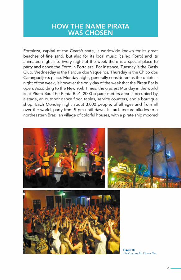
How THe nAMe PIRATA waS ChoSen
Fortaleza, capital of the Ceará’s state, is worldwide known for its great beaches of fine sand, but also for its local music (called Forro) and its animated night life. Every night of the week there is a special place to party and dance the Forro in Fortaleza. For instance, Tuesday is the Oasis Club, Wednesday is the Parque dos Vaqueiros, Thursday is the Chico dos Carangueijos’s place. Monday night, generally considered as the quietest night of the week, is however the only day of the week that the Pirata Bar is open. According to the New York Times, the craziest Monday in the world is at Pirata Bar. The Pirata Bar’s 2000 square meters area is occupied by a stage, an outdoor dance floor, tables, service counters, and a boutique shop. Each Monday night about 3,000 people, of all ages and from all over the world, party from 9 pm until dawn. Its architecture alludes to a northeastern Brazilian village of colorful houses, with a pirate ship moored
Figure 15: Photos credit: Pirata Bar.

22
in the background. The decoration and the dress of the waiters also refer to the theme of piracy. It has dancers with the visitors animate a typical Forro show.
During the TIP-4 Meeting held at Fortaleza in September 1995 some of the meeting’s members (still young and full of vigor at the time!) enjoyed “Fortaleza by Night”. Of course, the Pirata Bar was one of their favorite activities. In tribute of these memorable evenings the TAO-type Project over the tropical Atlantic was thought to be named PIRATA (for PIlot Research moored Array in the Tropical Atlantic). PIRATA was thought as a more colorful name to conventional alternatives.
Participants at subsequent PIRATA meetings held in Fortaleza paid homage at the Pirata Bar. In particular, PIRATA-SWE in February 2003, PIRATA-9 in December 2004, and more recently PIRATA-22 in November 2017, for the 20th anniversary of the first PIRATA mooring.
Figure 16: Photo J. Servain.

23
THe SyMBoLISM oF THe PIRATA Logo
A first attempt of a logo placed siren in the outline of the continents. Exploiting the idea of using the contour of the adjacent continents to the tropical Atlantic Ocean we adapted it to represent not a siren, but a sail. A sail that could be a pirate ship’s sail. The sail is seen from the front, the ship rushing towards us. We see its mast in the middle of the sail. The hull of the boat (hence its bow) is symbolized here by the shape of Kelvin waves at the equator and the Rossby waves on both sides of the equator.
Small colored disks placed on the sail, along the equator, and along the 38°W and 10°W axes represent the positions of the ATLAS buoys of the PIRATA backbone. The different colors of the disks symbolize the
Figure 17:A siren sketched between Africa and Brazil. Original sketch by Annie Servain.

24
subsequent periods of initial launching of the buoys, red for the first step, blue for the second step, yellow for the third step.
The pirate flag is replaced by a flag that symbolizes the transmission of meteorological and oceanic observations from the buoys to the satellite circling around the ship. The seagull gives a poetic touch to the whole.
Green is a favorite color of J. Servain. The gradation of darker green towards green-yellow of the tropical Atlantic Ocean towards 0°N, 35°W symbolize that atmospheric forcing in this region is of great importance in the equatorial dynamics. The name “PIRATA” in the logo links this logo to PIRATA program.
The graphic design of the logo has evolved along the years. On the first version, just before the start of PIRATA cruises, we note four yellow buoys, each one 2° on either side of the equator, the first two buoys at 35°W and the other two buoys at 10°W.
In the second version of the logo, the two “yellow” buoys at 2°N, 35°W and 2°S-35°W disappeared due to abandoning the idea of putting ATLAS buoys in areas of intense fishing which facilitated vandalism.
The Current (2017) PIRATA logo includes 18 buoys, ten of the original backbone, one for the PIRATA-SEE, three for the PIRATA-SWE, and four for the PIRATA-NEE.
Figure 18: The PIRATA first version logo (1995) with 14 buoys for the PIRATA backbone.
P I R A T A

25
Figure 19: The second version of the PIRATA logo (1999) with only 12 buoys.
Figure 20: A special edition of the PIRATA logo for the 20 years of PIRATA with 18 buoys including the PIRATA backbone (the two small yellow disks at 10°W are not operating) and the three extensions PIRATA-SWE, PIRATA-SEE and PIRATA-NEE.
P I R A T A
P I R ATA
1997 - 2017

26
The PIRaTa MUSIcAL BUoyS
Doing good science does not prevent having humor. We have already seen it before about the choice of the name of PIRATA (see §5). Because the PIRATA project is a tri-partite project Brazil, France and USA, we came up with the idea that the buoys that sway over the waves, could dance some of the musical rhythms of these three countries. We thus gave a name to the first twelve ATLAS buoys of the original PIRATA backbone. In the eastern side of the PIRATA network, maintained by France, we gave names of music or dances most common in France (Java), Central Europe (Waltz) or a French region, the Brittany (Gavotte). For the western side of the network serviced by Brazil, names of Brazilian regional rhythms such as Forro (Fortaleza, CE), Lambada (Natal, RN), Frevo (Recife, PE) or even Samba (Rio de Janeiro, RJ) were assigned. The northernmost ATLAS system at 38°W was named Reggae, and the remaining four buoys, along the equator had names reminiscent of the USA’s music: Jazz, Soul, Rhythm and Blues.
On the very first version of the web page of PIRATA France, when we clicked the buoys one could hear a brief musical extract according to the name of the buoy. Those were fun years!
Figure 21: The 12 “musical” buoys of PIRATA backbone, with the scheduled dates of first deployments.
20°N
10°N
0°
10°S
20°S50°W 40°W 30°W 20°W 10°W 0° 10°E 20°E
Third quarter 1997
First quarter 1999
Third quarter 1999
ADCP

27
Figure 22: Before the launching of Gavotte (10°S, 10°W) in September 1997. Photo J. Servain.
Figure 23: When the original PIRATA array extended through the Southeast (PIRATA-SEE) and the Southwest (PIRATA-SWE) these new buoys were also given names of dances/music. That is how the one-buoy of the PIRATA-SEE (pink triangle) was named Kizomba (6°S,8°E), the name of an Angolan dance. The three-buoys of the PIRATA-SWE (yellow disks) are Maracatu (8°S, 30°W), Axé (14°S, 32°W) and Bossa Nova (19°S, 34°W), all three as Brazilian dances. The sites of the PIRATA-NEE (blue stars) have no name. (The Americans are less musical than French and Brazilians!?).
25°N
20°N
15°N
10°N
5°N
0°
5°S
10°S
15°S
20°S
25°S70°W 60°W 50°W 40°W 30°W 20°W 10°W 0° 10°E 20°E
SouthwestExtension
SoutheastExtension(pilot site; funded)
NortheastExtension(proposed)
PIRATA backbone
2
22

28
TUnA FISHIng, VAndALISM And A RePULSIon deVIce
Certainly, one of the biggest challenge we had to face during the pilot phase of the PIRATA program (1997-2005) was the vandalism mainly due to the tuna fishing around the moorings. Any devices anchored or drifting in the tropical waters, especially in the upwelling areas, are rapidly colonized by pelagic species. Indeed, around an ATLAS mooring buoys there may be up to 100 tons of fish, mostly tuna.
Three tuna fleets work regularly in the Gulf of Guinea. The tuna seiners are mainly European (Spanish and French), but also Ghanaian. Asian longliners are mainly from Taiwan and Japan. A third flotilla, registered under flags of convenience, are pirate ships that practice illegal fishing.
The practice of purse seining consists of encircling a school of tuna close to the surface by unfolding around it a large net, which is then closed by the base to form a pocket from which the fish cannot escape. The ATLAS systems, fixed by an anchor, could be potentially a boon to these fishermen. However, scientific buoys are not of great interest to these vessels: not only is seine maneuvering impossible around an anchored buoy, but most have for many years their own fish attraction systems. Their drifting rafts are launched in potentially interesting areas and then recovered after a few days/weeks by the seine. In addition, French tuna ships are aware of the existence and interest of these weather-ocean buoys.
The longliners fish for bigger tuna several dozen meters deep using long lines stretched horizontally between 30 and 300 meters deep and equipped with thousands of hooks arranged at regular intervals. These lines are not anchored to the bottom and therefore drift according to the currents. Not targeting schools of tuna, this type of fishing is less dependent on attracting objects such as buoys, close to which large individuals can however be more abundant. Laying lines too close to the buoys can cause them to become entangled, possibly damaging the underwater sensors and the mooring line. This is what was observed on one of the buoys recorded in 2004 during a PIRATA-FR cruise. But this interaction linked to the fishing operation cannot explain the disappearance of buoys or electronic equipment. French fishermen having visited an Asian ship in the port of Abidjan thus testified to having seen a beautiful RM Young anemometer (the model used on the buoys) serving as a clipboard on the commander’s desk!
Pirate ships fish in contravention of international law (exclusive economic zones) and resource management regulations. Their catches are transhipped at sea on refrigerated freighters or other fishing vessels.

29
For the PIRATA network, the major problems were along the equator, where tuna is abundant (see figure below) and is attracted by the ATLAS buoy systems. Two ATLAS systems disappeared during the first year of the PIRATA program, both along the equator: at 10°W (after 2 months, in November 1997) and at 0°W (after 10 months, in October 1998). Both times, the damage was initiated a few weeks before the full loss of the ATLAS systems as indicated by the cessation of satellite transmissions of the wind measurements. The wind anemometers are very attractive and very fragile. Extra special care is needed during launching or retrieving the buoys to prevent damage.
Of the 81 buoys put in place during the 8 first years (1997-2005) of the PIRATA program, 7 disappeared and various incidents interrupted the collection or transmission of data on other buoys. On the other hand, most other buoys have been spared; in 2003, for the first time, the whole network worked without any problem, and even the 0 °, 0 ° buoy (which suffered the most losses, especially at the beginning) held throughout 2005.
Fortunately, the vandalism problem seemed to end in 2008, which is the last year when the buoy 0°, 0° was vandalized. Several possible explanations include: (i) an overfishing and therefore less good catch, (ii) the civil war in Côte d’Ivoire in the early 2000’s made ports of call for transshipment there less desirable, and (iii) tuna companies found better opportunities elsewhere, especially in the Indian Ocean.
Figure 24: Map of the catches of tuna between 1991 and 1999 based on data from French tuna ships operating in the tropical Atlantic. It is obvious that the equatorial axis of PIRATA was practically under threat. From A. Fonteneau.
30°N
20°N
10°N
0°
10°S
20°S60°W 50°W 40°W 30°W 20°W 10°X 0° 10°E

30
Figure 25: History of the 1997-2005 data return for each PIRATA site. Interruptions of the lines correspond to the periods of non-operation (or disappearance) of the buoys. Note that the sites 2°S and 2°N at 10°W were abandoned quickly, and that the site 5°S,10°W was moved in 2000 to 6°S, 10°W. The last buoys at 8°S, 14°S and 19°S were put in place at August 2005 as part of the PIRATA South West extension. From B. Bourlès.
Figure 27: The ATLAS buoy recovered by June 6, 2006, on the site of Valse (6°S-10°W) without any atmospheric instrument. Photo J. Servain.
15°N, 38°W
12°N, 38°W
8°N, 38°W
4°N, 38°W
0°, 35°W
0°, 23°W
2°N, 10°W
0°, 10°W
2°, 10°W
5°, 10°W
6°, 10°W
10°, 10°W
0°, 0°
8°S, 30°W
14°S, 32°W
19°S, 34°W
1997 1998 1999 2000 2001 2002 2003 2004 2005
Figure 26: Many RM Young wind sensors were poached as souvenirs for captains of Korean, Japanese, Ghanaian, or even European tuna ships. Photo credit: RM Young.

31
However, the good thing is that it was possible, before removing of the buoy, to make miraculous fishing. The crews of the French ships fished to their heart’s content, and we, the scientists, were very happy to enjoy incredible tuna treats with all sorts of cook preparation.
Figure 28: Examples of fishing of tuna (top), sea bream or maïe-maïe (left) and black mackerel (right) by the crews of the French R/V before each ATLAS removing. Photos J. Servain.

32
The problem of vandalism was widely discussed during the first yearly meetings of the PIRATA-SSC, which sometimes caused some tensions between the various members. Some, in particular the American members, wanting to reduce immediately the implementation of moorings in all the high-risk areas of vandalism (ex. 0°. 0°, named also “zero partout”), while other members, especially the French, wished to maintain them, at least during the pilot phase. Finally, an agreement was found by deleting the sites at 1°40N, 10°W 1°40S, 10°W, but by keeping the site 0°,0°.
To combat as much as possible against the risk of vandalism by fishermen, we initiated three actions. One action, more symbolic than effective, was to prepare a Recommendation for a United Nation’s Resolution to support efforts to reduce vandalism of oceanographic equipment at sea. The PIRATA-SSC and PRB prepared such a document during the PIRATA-5 Meeting which held in Abidjan, Côte d’Ivoire in November 1999.
A second action, also as a preventive, consisted in distributing to all tuna vessels calling at various ports in West Africa (notably Abidjan) a flyer which gave information on the ATLAS buoys and the PIRATA network. The main recommendation was to stay away from buoys, and especially to not hang on to them. These flyers were written in French, English, Spanish and Portuguese.
Figure 29: Flyer prepared to inform the fishermen community to not damage the moorings and other scientific equipment’s at sea.
33
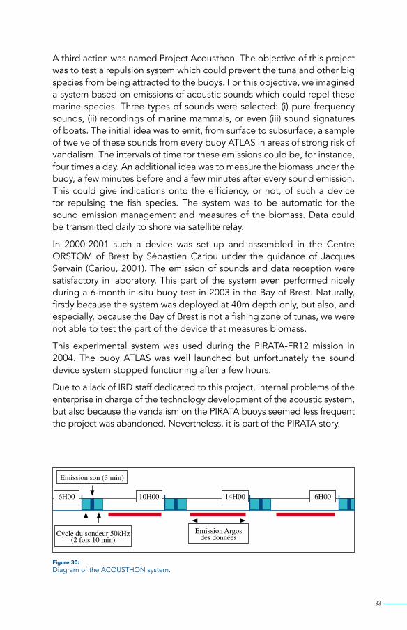
A third action was named Project Acousthon. The objective of this project was to test a repulsion system which could prevent the tuna and other big species from being attracted to the buoys. For this objective, we imagined a system based on emissions of acoustic sounds which could repel these marine species. Three types of sounds were selected: (i) pure frequency sounds, (ii) recordings of marine mammals, or even (iii) sound signatures of boats. The initial idea was to emit, from surface to subsurface, a sample of twelve of these sounds from every buoy ATLAS in areas of strong risk of vandalism. The intervals of time for these emissions could be, for instance, four times a day. An additional idea was to measure the biomass under the buoy, a few minutes before and a few minutes after every sound emission. This could give indications onto the efficiency, or not, of such a device for repulsing the fish species. The system was to be automatic for the sound emission management and measures of the biomass. Data could be transmitted daily to shore via satellite relay.
In 2000-2001 such a device was set up and assembled in the Centre ORSTOM of Brest by Sébastien Cariou under the guidance of Jacques Servain (Cariou, 2001). The emission of sounds and data reception were satisfactory in laboratory. This part of the system even performed nicely during a 6-month in-situ buoy test in 2003 in the Bay of Brest. Naturally, firstly because the system was deployed at 40m depth only, but also, and especially, because the Bay of Brest is not a fishing zone of tunas, we were not able to test the part of the device that measures biomass.
This experimental system was used during the PIRATA-FR12 mission in 2004. The buoy ATLAS was well launched but unfortunately the sound device system stopped functioning after a few hours.
Due to a lack of IRD staff dedicated to this project, internal problems of the enterprise in charge of the technology development of the acoustic system, but also because the vandalism on the PIRATA buoys seemed less frequent the project was abandoned. Nevertheless, it is part of the PIRATA story.
Figure 30: Diagram of the ACOUSTHON system.
Emission son (3 min)
Cycle du sondeur 50kHz (2 fois 10 min)
Emission Argos des données
6H00 10H00 14H00 6H00

34
The noR-50
Between recovering and refurbishment, the nominal life time of an ATLAS mooring at sea is about one year. It follows that roughly once a year, each ATLAS mooring must be raised in its totality (except the mooring block of 2 tons which is left remaining at the sea floor) and replaced by another ATLAS mooring installed right away at the same location. Excellent coordination is a prerequisite for ensuring efficient rotation of equipment between different African (eastern) and Brazilian (western) sites. With the current PIRATA network (18 sites in 2017) the annual load of ship time for its maintenance is obviously dependent of the start and return in seaports. Using classic R/Vs with a cruising speed of 11 Knots the total annual ship time, including Brazilian, French and USA services may exceed 12 months. However, an optimized maintenance of the network may require more than once a year visit, for instance in areas subject to vandalism connected to tuna fishing (see §8). Furthermore, these missions are repetitive, long-lasting and have to adapt themselves quickly to a multitude of chances (of material, economical order, even political) related to the maintenance of the network of observations. They involve semi-heavy (ATLAS buoys) and light autonomous equipment (e.g. Argo floats, current drifters, …), and a limited number of scientific staff (3 to 4 persons), with a crew of about 10 people. They cover oceanic distances on the basin scale and the time of transit is dominating the time spent on station.
Given these constraints, and in order facilitate and to optimize the tri-national field activities of the PIRATA network, P. Marchand and J Servain (Marchand and Servain, 2001) have proposed a new approach to yearly service yearly the PIRATA network of about 20 ATLAS in the tropical Atlantic.
The purpose was to focus on a fast vessel, a feature that makes sense only if it is a light vessel. The simplicity of missions to carry out allows precisely to consider a ship with a limited payload capability, and an accordingly small displacement, resulting in fuel costs noticeably smaller than that of a classic R/V. Marchand and Servain adopted the following functional specifications for a such fast oceanographic vessel (named “NOR-50” for “Navire Océanographique Rapide de 50 m”):- Autonomy: 5000 Miles (trans-oceanic capability)- Speed: 22 Knots in cruise (twice that of a classic R/V)- Payload: 15 Tons (e.g. 4 complete PIRATA/ATLAS buoys)- Capability to moor/remove at least PIRATA/ATLAS buoys- Crew: 10 persons, and 4 scientists

35
The budget for the NOR-50 ship itself would be 5 M$ US. This price should be compared with the 30 M$ US estimated for a classical 55 m monohull R/V.
This solution of fast and functional R/V for operational oceanography was reinforced by the idea of a projected international center at the INPE at Natal, RN, Brazil, which would have been intended to centralize a large part of the operations linked to PIRATA and other operational oceanographic activities. For instance it would have been possible to maintain the entire PIRATA network from Natal, which geographically speaking, is an ideal place to operate throughout the tropical Atlantic.
Neither the NOR-50 nor the proposed Natal Center were pursued by the various governmental authorities at the time. This attempt is also part of the PIRATA story.
Figure 31: Cover page of the Marchand and Servain’s article about the NOR-50 which was published in Sea Technology, 2002.

36
THe THRee PHASeS oF PIRATA, THe PRB And THe MoU
The pilot phase of PIRATA started in 1997 with the launching of the first mooring in September 1997. Initially programmed for a 3-year phase (1997-2000), which actually finished in 2001. A PIRATA Resources Board (PRB) was established in 1999 with Mike Jonhson (NOAA) as the first Chairman and representative of USA. Other members were representatives of France (Jacques Merle for ORSTOM/IRD and Daniel Cariolle for Météo-France) and representative of Brazil (Volker Kirchoff for INPE). During June-December 1999, with the help of some PIRATA-SSC members, these PRB members drafted Terms of Reference for the 5-year (2001-2006) consolidation phase of the PIRATA “backbone”.
Figure 32:Draft of a Resolution prepared by the PIRATA-SSC to create the PIRATA Resources Board (PRB).

37
The first informal PRB meeting was held in Saint Raphaël, France in October 1999, during the International Conference “Oceanobs 99” dedicated to the “The Ocean Observing System for the Climate”. A PRB meeting is always held during annual PIRATA-SSC meetings.
Figure 33: Facsimilé of a handmade note written by Jacques Servain (and kept by Divino Moura) for the announcement of the first PRB Meeting at Saint Raphaël, France, in October 1999.
To specify commitments (financial, human, vessel time) a first Memorandum of Understanding (MoU) was officially signed in August 2001 by the institutional representatives. This MoU defined the responsibility of partners during the consolidation phase of PIRATA (2001-2006, then later to 2008).
After a positive scientific evaluation of the PIRATA program by CLIVAR and OOPC (established from the document Bourlès et al., 2006), a new MoU was written in 2006 to 2008 which was signed in February 2, 2009, by the four institutions INPE (Brazil), IRD and Météo-France (France) and NOAA (USA), during the PIRATA 14 meeting organized in Toulouse to ensure the maintenance of the program until 2013.

38
During the yearly PIRATA meeting in 2013, the MoU which was ending in July 2014 was extended for an additional five-year period (until July 2019) through an amendment.
Figure 34: The participants of the Meeting PIRATA-11 at Natal in 2006 during the preparation of the article “The PIRATA Program: History, Accomplishments, and Future Directions”. With (front from left to right) Paulo Nobre, Tony Busalacchi, Jacques Servain, Mike McPhaden, and (behind, from left to right) Edmo Campos, Janice Trotte, Divino Moura and Bernard Bourlés. Note that this picture was taken exactly at the same place as the picture of the Meeting PIRATA-1 ten years before. Photo J. Servain.
Figure 35: Cover of the BAMS, Vol. 89, N° 8, published in August 2008 with inside the Article “The PIRATA Program: History, Accomplishments, and Future Directions” by B. Bourlès et al.

39
PIRaTa In THe MedIA
Several large public articles, published in various daily newspaper, weekly or monthly magazines, have been published during the first years of PIRATA, mainly in France, and sometime in Brazil. For instance, the scientific reporter S. Huet from the French national newspaper “Libération” was invited by J. Servain to attend the PIRATA-5 Meeting which took place in Abidjan in November 1998. He wrote an article entitled “L’Océan Maître du Temps”, published in “Libération” in 1st December 1998. Following the article published by S. Huet in “Libération”, the producer of the French documentary series “Thalassa” contacted J. Servain to report at of a PIRATA cruise. “Thalassa” is a very popular broadcast, weekly programmed on prime time on the French TV channel FR3, which is dedicated to various maritime activities. The appointment to participate in the mission PIRATA-FR3 in January 1999 from Abidjan was made. Three people from the French television (a reporter, a cameraman and a soundman) embarked on the R/V Antéa and they filmed the all launching operations of two ATLAS buoys. The 30-min documentary “La mer vue du ciel” went on the air of FR3-TV in June 1999.
Invited by J. Servain to attend his lecture at the University of Paris 6 in February 2001 about the presentation of the NOR-50 Project, S. Huet published a second article in “Libération” entitled “Un trimaran au secours des bouées”.
Other articles were published in various newspapers and magazines as “O Povo”, “Le Marin”, “Le Monde Interactif”, “Sciences & Avenirs”, “Hebdo Micro”, etc.

40
Figure 36: A selection of the articles published in newsletters and magazines during the first years of PIRATA.

41

42
PIRATA’S BoUTIqUe
It was of tradition during the first PIRATA meetings that some personalized souvenirs were edited, most of the time in the effigy of the PIRATA logo. That were for instance T-shirts, caps, pirate cards, mugs, placemats, etc …
Figure 37: Some souvenirs edited during the first years of PIRATA.

43
PHoTo gALLeRy
Figure 38: Images of some good moments with the three authors ….

44
AcknowLedgMenTS
INPE, IRD (formerly ORSTOM), NOAA, Minister of Science and Technology (Brazil), Météo-France, CNRS, IFREMER
The first members of PIRATA-SSC (1995-2005)The first members of PRB (1999-2006)All the Brazilian, French and US scientific crews and technical staff who
participated in PIRATA cruises.Scientific, technical and engineering staff at national laboratories in the
USA (PMEL, AOML), France (LEGOS, LOCEAN) and Brazil (INPE, UFPE, USP, FUNCEME) who provided essential support and guidance for the success of PIRATA.
All the Brazilian, French, USA and African colleagues and students who participated on the first cruises of PIRATA
Special thanks for J. Grelet, F. Gallois, F. Roubaut, B. Bourlès, …
Original painting by Françoise Grelet

45
lIST of RefeRenCeS
Bourlès B., lumpkin r., mcphaden m. J., campos e., hernandez F., noBre p., planton s., Yu l., Busalacchi a. J., moura a. d., servain J., and trotte J., 2008 : The PIRATA Program: History, Accomplishments, and Future Directions. Bulletin of the American Meteorological Society (BAMS), Vol. 89, N° 8, 1111-1125.
marchand p. and servain J., 2002: The NOR-50: A Tool for Operational Oceanography. Sea Technology, Vol. 43, N° 6, June 2002, pp 49-54.
servain J., Busalacchi a., moura a., mcphaden J., reverdin G., vianna m., and zeBiak S., 1998: A Pilot Research Moored Array in the Tropical Atlantic (PIRATA). Bulletin of American Meteorological Society, 79, 2019-2031.
cariou S., 2001: Etude du comportement des thons par stimulation acoustique. Report published by Centre IRD of Brest, France.
PRess ReFeRences
huet S., “L’Océan maître du temps », Libération, December 1st, 1998, 30-31.
huet, S., “Un trimaran au secours des bouées”, Libération, February 28, 2001, 22.
« L’Atlantique a aussi son Niño », Sciences & Avenir, M 2667 – 624, February 1999, 29.
servain, J., « Le Niño de l’Atlantique », Sciences & Avenir, M 2667 -626, April 1999, 130.
thomas, A., « L’Océan en direct sur Internet », Hebdo Micro, 50, April 1999, 32-33.
Thalassa « La mer vue du ciel », Télérama, 12-18 June 1999, 2578, 179.
thomas, A., « Un bouchon sur l’océan », Le Monde Interactif, April 7, 1999, VII.
thomas, A., « PIRATA piraté dans le Golfe de Guinée, Le Marin, Mars 19, 1999, 15.
« Estudo do clima nordestino terá base em Fortalezaé, O Povo, October 2002, 10.

46
aPPendIX 1PRB And PIRATA-SSc MeMBeRSHIPS 1995-2005
Membership of PIRATA Resources Board (PRB) and PIRATA Scientific Steering committee (PIRATA-SSc)
a) PIRATA Resources Board (PRB)
1999-2003Mike Johnson (Chair), NOAA, USADaniel Cariolle, Météo-France, FranceVolker Kirchhof, INPE, BrazilJacques Merle, IRD, France
2003-2004Mike Johnson (Chair), NOAA, USAJacques Boulègue, IRD, FranceDaniel Cariolle, Météo-France, FranceVolker Kirchhof, INPE, Brazil
2005-2006Mike Johnson (Chair), NOAA, USAJacques Boulègue, IRD, FranceJoël Poitevin, Météo-France, FranceMaria Assunção F. Silva Dias, INPE, Brazil
47
b) PIRATA Scientific Steering committee (PIRATA-SSc)
1995-1998Antonio Divino Moura (Co-Chair), INPE, BrazilJacques Servain (Co-Chair), IRD, FranceAntonio Busalacchi, NASA/GSFC, USAMichael McPhaden, NOAA/PMEL, USAGilles Reverdin, CNRS, FranceMarcio Vianna, INPE, BrazilSteve Zebiak, LDEO/IRI, USA
1999-2001Jacques Servain (Chair), IRD, FranceAntonio Busalacchi, NASA/GSFC, USAPing Chang, Texas A&M Unviv., USAMichael McPhaden, NOAA/PMEL, USAAntonio Divino Moura, INPE, BrazilSerge Planton, Météo-France, FranceGilles Reverdin, CNRS, FranceMarcio Vianna, INPE, BrazilIlana Wainer, USP, Brazil
2001-2002Jacques Servain (Chair), IRD/LEGOS, FranceBernard Bourlès, IRD/LEGOS, FranceAntonio Busalacchi, ESSIC, University of Maryland, USAJoão Lorenzzetti, INPE, BrazilMichael McPhaden, NOAA/PMEL, USAAntonio Divino Moura, INPE, BrazilSerge Planton, Météo-France, FranceIlana Wainer, USP, BrazilShang Ping Xie, Univ. Hawaii, USA
2003-2004Jacques Servain (Chair), IRD/LEGOS, FranceBernard Bourlès, IRD/LEGOS, FranceAntonio Busalacchi, ESSIC, University of Maryland, USAEdmo Campos, USP, BrazilMichael McPhaden, NOAA/PMEL, USAPaulo Nobre, INPE, BrazilSerge Planton, Météo-France, FranceShang Ping Xie, Univ. Hawaii, USA
2004-2005 Antonio Divino Moura (Chair), INMET, BrazilBernard Bourlès (Co-Chair), IRD/LEGOS, FranceAntonio Busalacchi, ESSIC, University of Maryland, USAEdmo Campos, USP, BrazilRick Lumpkin, NOAA/AOML, USAMichael McPhaden, NOAA/PMEL, USAPaulo Nobre, INPE, BrazilSerge Planton, Météo-France, FranceJacques Servain, IRD/LOCEAN, France

48
aPPendIX 2PIRATA MeeTIngS: 1995 - 2006
a) International PIRATA-SSc meetings:
PIRATA-0: TIP-4, Fortaleza, Brazil, September 1995PIRATA 1, Natal, Brazil , February 1996PIRATA-2, Brest, France, August 1996PIRATA-3, Seattle, WA, USA, March 1997PIRATA-4, Niteroi, Brazil, November 1997PIRATA-5, Abidjan, Côte d’Ivoire, November 1998PIRATA-6, Miami, USA, May 1999PIRATA-7, Natal, Brazil, April 2000PIRATA-7.5, Fortaleza, Brazil, September 2000PIRATA-8, Paris, France, August 2001PIRATA-9, Angra dos Reis, Brazil, Feburary 2003PIRATA-10, Fortaleza, Brazil, December 2004PIRATA-11, Toulouse, France, October 2005
b) extensions PIRATA meetings:
PIRATA-SEE, Cape Town, SA, December 1999PIRATA-NEE, Casablanca, Morroco, March 2000PIRATA-SWE, Fortaleza, Brazil, September 2000
c) PIRATA-SSc Meeting dedicated to the PIRATA Review (BAMS-2008):
PIRATA-Review, Natal, Brazil, February 2006
d) Joint Assembly – AgU Spring Meeting, Montreal, 17-21 May 2004
May 19, Special session: Scientific Results for the PIRATA Program 1997-2004Conveners: Jacques Servain, Shang-Ping Xie, Edmo Campos (12 oral communications)


Rise of PIRATA1995-2005
An ATLAS buoy moving at 10 knots, pulled by its 2-ton anchor, sinking into abyss at the time of launch.
Dr. Jacques Servain was born in France (1947). He is now retired from IRD, and Research Director emeritus at IRD/LOCEAN, Paris, France. He is also a visiting scientist at Funceme, Fortaleza, CE, Brazil. He was Chairman or Co-Chairman in PIRATA-SSC from the beginning (1995) until end of 2004. Dr. Antonio Divino Moura was born in Brazil (1945). He is now Head of CPTEC/INPE and INPE’s Deputy Director, São José dos Campos-SP, Brazil. He was Co-Chairman or Chaiman of PIRATA-SSC from 1995 until 2006. Dr. Michael McPhaden was born in the USA (1950). He is presently a Senior Scientist at PMEL/NOAA in Seattle, WA, USA and has been a member of the PIRATA-SSC from its very beginning.