the role of hydrocarbon production on land subsidence...
TRANSCRIPT

Journal of Coastal Research 23 3 771–786 West Palm Beach, Florida May 2007
The Role of Hydrocarbon Production on Land Subsidenceand Fault Reactivation in the Louisiana Coastal ZoneAlvin W. Chan* and Mark D. Zoback
Department of GeophysicsStanford UniversityStanford, CA 94305-2215, [email protected]@pangea.Stanford.edu
ABSTRACT
CHAN, A.W. and ZOBACK, M.D., 2007. The role of hydrocarbon production on land subsidence and fault reactivationin the Louisiana coastal zone. Journal of Coastal Research, 23(3), 771–786. West Palm Beach (Florida), ISSN 0749-0208.
We use a simple analytical model of reservoir compaction and a numerical model incorporating both reservoir com-paction and fault slip to investigate surface subsidence in the area of the Lapeyrouse Field in southern Louisiana. Areleveling survey shows approximately 20 m of elevation change over a 30 years time period that includes the periodof extensive oil and gas production from a number of reservoirs at depth. The degree and extent of subsidence esti-mated from a simple analytical model of compaction predicts approximately half of the elevation change measuredfrom the releveling surveys. Incorporating the impact of compaction-induced slip along the Golden Meadow Fault,located at the northern edge of the Lapeyrouse Field, on surface subsidence still does not account for all of themeasured subsidence. Coastal wetland loss is a result of complicated process and it is difficult to isolate the impactof specific mechanisms. This study suggests that land subsidence induced by hydrocarbon production is one of severalmechanisms that need to be considered when evaluating localized subsidence and wetland loss in the Louisiana coastalzone.
ADDITIONAL INDEX WORDS: Land subsidence, fault reactivation, hydrocarbon production, reservoir compaction.
INTRODUCTION
Coastal wetland loss is caused by complicated interactionsbetween natural and human activities. BRITSCH and DUN-BAR (1993) suggested that wetland loss should be defined asvegetated wetlands that change into (i) uplands or drainedareas, (ii) nonvegetated wetlands (e.g., mudflats), and (iii)submerged habitats. For coastal wetland to survive in a rapidsubmerging region, accumulation of both organic and inor-ganic soils has to keep pace (BRITSCH and DUNBAR, 1993).Extensive areas of salt, brackish, and locally fresh marshesalong the coast of northern Gulf of Mexico have been con-verted to areas of open water and flats in the last 50 years(e.g., BRITSCH and DUNBAR, 1993; PENLAND et al., 2000). TheLOUISIANA COASTAL WETLANDS CONSERVATION AND RES-TORATION TASK FORCE AND THE WETLANDS CONSERVATION
AND RESTORATION AUTHORITY (1998, referred to as COAST2050 hereafter) reported in 1998 that 40% of the UnitedStates’ coastal wetland is located in the Louisiana coastalzone; land loss in this region since the 1930s has accountedfor 80% of the total coastal land loss in the United States.The loss of wetlands in Louisiana has significant social, eco-
DOI: 10.2112/05-0553 received 29 September 2005; accepted in revi-sion 27 February 2006.
* Present address: Shell International Exploration and Produc-tion, Inc., 3737 Bellaire Blvd, Houston, TX 77025, U.S.A.
This work was supported by the U.S. Geological Survey(00HQAG0223-0004) and the Stanford Rock Physics and BoreholeGeophysics Project.
nomic, and ecological impacts. The coastal zone hosts a largeportion of the nation’s coastal fisheries and migratory water-fowl population; it also acts as a buffer zone for in-land hu-man population from hurricanes and storms (e.g., FARBER,1987). With over 2 million residents living in the coastal zone(�46% of the state’s population), the severe land loss pro-jected in the next 50 years will cost Louisiana more than$37B (COAST 2050). Using color and infrared aerial photo-graphs, BRITSCH and DUNBAR (1993) show that the 36 km2/yr wetland loss rate in Louisiana between the 1930s to the1950s was dominated by shoreline erosion. The statewideland loss rate increased dramatically (�100 km2/yr) from1960–80, the majority of the land loss during this time oc-curred in the interior with local ‘‘hotspots’’ that began assmall pockets of open water and progressively expanded intolarge open water with small vegetated islands. The land lossrate declined back to about 65 km2/yr in the 1990s. The peakof land loss rate in the 1970s seems to coincide with the peakoil and gas activities in the region (e.g., MORTON, BUSTER,and KROHN, 2002). In this paper, we will examine the im-pacts of oil and gas production in southern Louisiana on landsubsidence and fault reactivations in an attempt to charac-terize the elevation change experienced in some of the local‘‘hotspots’’ in the Louisiana coastal zone.
The process of wetland loss is a combination of land sub-sidence, eustatic sea level rise, sediment supply, erosion, fill-ing, and drainage (BOESCH et al., 1994). However, the extentof wetland loss is not a good indicator of the severity of land

772 Chan and Zoback
Journal of Coastal Research, Vol. 23, No. 3, 2007
subsidence due to the complicated interactions between nat-ural and human activities in both the surface and the sub-surface. There are several mechanisms involved in coastalLouisiana that can lead to the submergence of wetlands:
(1) Ongoing consolidation of Holocene sediments of theMississippi River Delta. This mechanism results in a spa-tially variable but temporally constant subsidence pattern(e.g., SUHAYDA et al., 1993). In other words, if the sedimentconsolidation rate is consistence, the amount of land subsi-dence in the delta will be primarily controlled by the spatialdistribution of Holocene sediments. Similar studies on com-paction of deltaic sands and shales in other parts of the world,such as the coastal area of the Netherlands, suggest that Ho-locene sediment compaction may have a first order effect onland subsidence (KOOI, 1997, 2000; KOOI and DE VRIES,1998) and contribute to a subsidence rate between 0.1 mm/yr and about 1 mm/yr (KOOI and DE VRIES, 1998);
(2) Regional subsidence as a result of lithospheric flexureresponse to sediment loadings (e.g., SCARDINA, NUNN, andPILGER, 1981) and/or subsidence of Pleistocene and older sed-iments (e.g., PAINE, 1993). PAINE (1993) suggests that thegeological subsidence rate for Pleistocene strata along theTexas coast is consistently at 0.05 mm/yr;
(3) Relative sea-level change results in a temporally vari-able but spatially constant subsidence pattern across the en-tire coastal zone (e.g., PENLAND et al., 1988; PENLAND andRAMSEY, 1990; ROBERTS, BAILEY, and KUECHER, 1994; SU-HAYDA, 1987). The mean global sea-level rise is estimated tobe 12 mm/yr (GOMITZ et al., 1982) and the relative sea-levelrise in the Gulf of Mexico is about 23 mm/yr (GOMITZ et al.,1982). The difference (11 mm/yr) between the global and Gulfof Mexico relative sea level rise rates can be attributed togeosyncline downwarping; compaction of Tertiary, Pleisto-cene, and Holocene deposits; consolidation; subsurface fluidwithdrawal; and regional tectonics (PENLAND et al., 1988).
(4) Natural movement on growth faults along the coastand the continental shelf of the Gulf (e.g., GAGLIANO et al.,2003a, 2003b). These studies proposed that the massive landloss in coastal Louisiana is a result of the episodic movementalong the east–west trending growth faults along the entirecoast. The slip rates are determined using tide gauges andreleveling line over a span of 10 to 30 years (GAGLIANO et al.,2003a). However, the long time span between releveling cam-paigns along with other high frequency signals (e.g., eustaticsea-level changes) recorded by the tide stations, the actualtiming (or frequency) of fault slip is extremely difficult to de-termine. Given a large uncertainties associated with the de-termining the frequency of slip along faults, the estimatedslip rates reported can be uncertain.
(5) Hydrocarbon production-induced fault reactivation(e.g., MORTON, BUSTER, and KROHN, 2002; MORTON, PUR-CELL, and PETERSON, 2001; MORTON, TILING, and FERINA,2003; WHITE and MORTON, 1997) and reservoir compaction(e.g., SHARP and HILL, 1995). Studies in other parts of theworld have demonstrated that reservoir compaction can havea significant impact on surface subsidence. For instance, upto 10 m of subsidence was observed at Long Beach, Califor-nia, over the Wilmington oilfield between 1926 to 1967 (e.g.,COLAZAS and STREHLE, 1995) and more than 3 m of subsi-
dence at the Ekofisk field in the North Sea during the first20 years of production (e.g., SULAK, 1991).
While the first four mechanisms suggested a maximumland surface subsidence rate of about 3 mm/yr, the historicalrate in some part of Louisiana recorded ranged from 9 mm/yr to as high as 23 mm/yr locally in the past few decades(MORTON, BUSTER, and KROHN, 2002). It is thus apparentthat natural processes maybe inadequate to explain the highsubsidence rates observed in some parts of coastal Louisiana.Production-induced surface subsidence as a result of reser-voir compaction and fault reactivation may have some sig-nificant impact locally. The Lapeyrouse Field located inSouthern Louisiana (described at length below) was chosenas study site to determine the role of hydrocarbon produc-tions on land surface subsidence.
Human-induced land subsidence along coastal Gulf of Mex-ico due to subsurface fluid withdrawal was first reportedalong the Texas coast and has been studied extensively insome areas (e.g., NEIGHBORS, 1981; PRATT and JOHNSON,1926; SWANSON and THURLOW, 1973). The major cause ofhuman-induced subsidence is the withdrawal of undergroundfluids, including water, oil, and gas. In the Houston-Galves-ton area, land subsidence induced by large-scale groundwaterwithdrawal since 1906 has been up to 3 m (GABRYSCH andCOPLIN, 1990) with the ‘‘subsidence bowl’’ formed in theHouston area encompassing more than 10,000 km2. The im-plication of elevation changes in coastal wetlands can havedramatic impact on the wetland ecosystem as REED and CA-HOON (1993) suggest that a slight decrease in elevation canlead to frequent flooding that can deteriorate vegetation. Ero-sion due to the loss of vegetation will further accelerate theloss of wetlands in these areas. WHITE and TREMBLAY (1995)reported that wetland loss along the upper Texas coastal areaincluding the Bolivar Peninsula in East Galveston Bay, theNeches River Valley at the head of Sabine Lake and the in-terfluvial area between the Sabine Lake and the Galvestonbay were likely results of hydrocarbon production-inducedfaulting and subsidence. WHITE and TREMBLAY (1995) re-ported that the rate of wetland loss has declined since the1980s due to the dramatic reduction in the rate of ground-water production-induced subsidence as a result of curtail-ment of groundwater pumpage after the 1970s.
Unlike coastal Texas, the link between subsurface fluidwithdrawal and subsidence-induced wetland loss in coastalLouisiana is more difficult to establish because wetland lossis widespread and caused by many processes and conditions(e.g., COLEMAN and ROBERTS, 1989; WILLIAMS, PENLAND,and ROBERTS, 1994). The relationship between hydrocarbonproduction and Louisiana coastal wetland loss is poorly un-derstood. Only a few authors have investigated the potentialimpact of oil and gas production on subsidence in this region(e.g., BOESCH et al., 1994; COLEMAN and ROBERTS, 1989;MORTON, PURCELL, and PETERSON, 2001; SUHAYDA, 1987).Most of the authors prior to MORTON et al. (2001) concludedthat subsidence caused by hydrocarbon production in coastalLouisiana is negligible due to the depth of the reservoirs orthat the subsidence affect only the immediate area and donot affect the wetland on a regional scale. However, as MOR-TON, PURCELL, and PETERSON (2001) pointed out, these con-

773Production-induced Land Subsidence and Fault Reactivation
Journal of Coastal Research, Vol. 23, No. 3, 2007
Figure 1. Cumulative annual production data for Lapeyrouse Field (af-ter Morton et al., 2002).
clusions regarding minimal impacts of hydrocarbon produc-tion were neither based on subsurface data from the produc-ing fields nor any numerical or analytical models that incor-porate the physical changes of the formations associated withdepletion and the corresponding stress changes. Using coresamples and releveling data, MORTON, BUSTER, and KROHN
(2002) demonstrated that the changes in the historical sur-face subsidence rates in certain part of coastal Louisiana ap-pear to correspond with the hydrocarbon production rates inthose areas (Figure 1). The appearance of some surface faulttraces after the 1970s also led them to propose the potentialof fault reactivation as a contributor of surface subsidence.To investigate the validity of the proposal by MORTON, BUST-ER, and KROHN (2002), we will use both analytical and nu-merical models to examine and demonstrate the implicationsof reservoir depletion on surface subsidence in the vicinity ofthe Lapeyrouse Field.
In situ stress and pore pressure measurements along withthe constitutive laws will be analyzed in the context of a for-malism termed Deformation Analysis in Reservoir Space(DARS) to estimate the change in porosity (or volumetricstrain) as a result of production (see detailed discussion ofDARS by CHAN, 2004; ZOBACK, CHAN, and ZINKE, 2001).Combining the estimated strains and the geometry of the res-ervoirs, the amount of reservoir compactions can be deter-mined. We then use both analytical and numerical methodsto analyze the impact of compaction on surface subsidence.Using an analytical method for single disc-shaped reservoirs(GEERTSMA, 1973), we estimate the magnitude of surfacesubsidence based solely on reservoir compaction. By address-ing the problem numerically, surface subsidence is estimatedbased on realistic reservoir shapes along with the locationand magnitude of production-induced fault slip. These resultsare then compared with the actual releveling data.
PRODUCTION-INDUCED LAND SURFACESUBSIDENCE
Analytical and numerical models have been proposed sincethe 1970s in an attempt to relate surface subsidence with oil
and gas production. Based on a simple nucleus-of-strain con-cept based on thermoelastic theory, GEERTSMA (1973) esti-mated the surface subsidence as a response to the production-induced compaction of a disc-shaped oil and gas reservoir atdepth (see Appendix). VAN HASSELT (1992) studied the Gron-ingen gas field in the Netherlands with several two-dimen-sional models and successfully demonstrated that theGEERTSMA (1973) solution can be used for estimating pro-duction-induced land surface subsidence. He also validatedthe predicted subsidence by field observations and showedthat the results were comparable to those from a more com-plicated finite element method. GEERTSMA (1973) assumed aconstant formation compressibility and linear stress-strainrelationship throughout the entire half-space. However, thisis not representative of weak sand reservoirs in the Gulf ofMexico that show some elastic–viscoplastic deformation dur-ing depletion (CHAN, 2004; CHAN, HAGIN, and ZOBACK,2004).
The GEERTSMA (1973) solutions stated that the magnitudeof surface subsidence, uZ, is a function of pressure change,�PP, in the reservoir, the compressibility, cm, and Poisson’sratio, �, of the material, such that:
uz(r, 0) � �2cm(1 � �)�PPHA(�, ) (1)
where � and are dimensionless parameters and can be de-fined as � � r/R and � D/R. D, H, and R are the depth,thickness, and the radius of the reservoir, respectively. Thesolution for A is a linear combination of the elliptic integralsof the first, second and third kind (see Appendix). To incor-porate a more complicated rheology to the GEERTSMA (1973)solution, we replaced �2cm(1 � �)�PPH in Equation 1 withreservoir compaction, �H, estimated from the DARS analysissuch that:
uz(r, 0) � �HA(�, ) (2)
This modification allows us to use the DARS formalism toestimate the amount of compaction that may occur in eachindividual reservoir and translate the results to surface sub-sidence as a function of pressure and/or time by super-posi-tioning the effects from all reservoirs.
Without considering the impact of background regionalsubsidence (which we cannot independently constraint), weexamine whether such a simple analytical model can gener-ate a local subsidence profile of the same order of magnitudeas the observed elevation changes. Since the physical prop-erties of the reservoirs are heterogeneous and cannot be fullymodeled by circular discs with uniform thickness, we do notexpect to capture characteristics of the observed elevationchanges in fine detail.
PRODUCTION-INDUCED FAULT REACTIVIATION
Extensive studies on induced-seismicity as a result of sub-surface fluid injection and withdrawal have been conductedsince the 1960s (e.g., BARANOVA, 1999; DAVIS, NYFFENEG-GER, and FROHLICH, 1995; DOSER, BAKER, and MASON,1991; EVANS, 1966; GRASSO, 1992; GRASSO and WITTLINGER,1990; MCGARR, 1991; MEREU et al., 1986; PENNINGTON etal., 1986; RALEIGH, HEALY, and BREDEHOEFT, 1976; SEGALL,

774 Chan and Zoback
Journal of Coastal Research, Vol. 23, No. 3, 2007
Figure 2. Schematic cross section of deformation surrounding a deplet-ing reservoir (after Segall, 1989).
1985, 1989, 1992). Most of these studies demonstrated thatthe number of seismic events in the proximity of producingoil or gas field increases significantly after production or in-jection began. It is well documented that mechanical insta-bility induced by fluid injection is related to the increase ofpore pressure which allows slip on pre-existing faults by low-ering the effective normal stress (e.g., EVANS, 1966; RA-LEIGH, HEALY, and BREDEHOEFT, 1976). Based on this ar-gument, the reduction of pore pressure as a result of produc-tion should inhibit faulting. However, observations and stud-ies of seismic events around different oil and gas fieldsaround the world suggested that depletion will result in achange in stress around the reservoir that may encourage slipon faults outside of the reservoir (e.g., BARANOVA, 1999; DA-VIS, NYFFENEGGER, and FROHLICH, 1995; DOSER, BREAKER,and MASON, 1991; GRASSO and WITTLINGER, 1990; MCGARR,1991; MEREU et al., 1986; PENNINGTON et al., 1986; SEGALL,1985, 1989, 1992).
Using poroelastic theory with an assumption of an ellip-soidal reservoir embedded in an elastic medium, SEGALL
(1985, 1989, 1992) calculated stress changes surrounding ahydrocarbon reservoir induced by reduction of pore pressureinside the reservoir. The stress changes can result in faultreactivation in the proximity of the reservoir (Figure 2) lead-ing to reverse faulting above and below the reservoir whilenormal faulting occurring near the edge of the reservoir.
While the Segall solution analytically calculates stresschanges and the potential of fault reactivation in the vicinityof the depleting reservoir, the impact of the compaction of anirregular shaped reservoir on a non-planar fault surface isbest estimated using numerical modeling. Therefore, we usethe Poly3D software developed by THOMAS (1993) to examinethe impact of hydrocarbon production on a fault located out-side of the depleting reservoir. Instead of coupling pore pres-sure history with surface subsidence and fault slip as in theanalytical solutions, we apply compactions determined fromthe DARS formalism for each individual reservoir as a bound-ary condition. Driven by reservoir compaction, Poly3D is usedto determine the location and magnitude of slip along thefault surface. We model the compacting reservoir as a planardiscontinuity surface embedded in an elastic medium. Withour interest mainly focused on deformation above the reser-voir, we only consider the top surface of the structure anddisplace the surface downward uniformly to simulate com-
paction based on the calculated values. In other words, com-paction in Poly3D is simulated by negative displacement ofthe planar surface along the z-axis. Assuming the fault sur-face is free of traction and is able to slip in any directionwithin the fault plane (i.e., no opening or closing of the fault),the magnitude and location of slip induced by reservoir com-paction can be estimated. In reality, fault surfaces may notbe traction-free, it is a reasonable assumption since growthfaults in the coastal area are active and constantly slipping(KUECHER et al., 2001). As a result, the estimate from Poly3Drepresents the maximum slip that can occur on the faultplane due to reservoir deformation.
LAPEYROUSE FIELD, LOUISIANA
The Miocene-aged Lapeyrouse Field is located west of Mad-ison Bay in the Terrebonne Parish in Southern Louisiana(Figure 3). Both geological and historical subsidence rateshave been published for this region. Carbon dating of sedi-ment cores in the Madison Bay area suggest that the Holo-cene sediments had an average subsidence rate of 1.4 mm/yrfor the last 500 years (FRAZIER, 1967); ROBERTS, BAILEY, andKUECHNER, 1994) reported that the average rate of subsi-dence in the region was about 2.7 mm/yr for the last 5000years. These results are comparable to the tide gauge mea-surements at Houma prior to 1962 when the measured sub-sidence rate averaged about 0.7 mm/yr (PENLAND et al.,1988). However, the historical subsidence rate in the MadisonBay area seems to have increased significantly since 1962:PENLAND et al. (1988) reported 19.4 mm/yr of subsidence atthe Houma tide gauge between 1962 and 1982; subsidencerates estimated from surface elevation table (SET) measure-ments (CAHOON, DAY, and REED, 1999) and recent sedimentcores (MORTON, TILING, and FERINA, 2003) are about 23 mm/yr. Moreover, two regional leveling lines are available in thisarea with the Bayou Petit Calliou Relevel Line transectingthe Lapeyrouse Field (MORTON, BUSTER, and KROHN, 2002).Based on the Bayou Petit Calliou relevel line, MORTON,BUSTER, and KROHN (2002) reported that the highest localsubsidence rate of 9.3 mm/yr within the Madison Bay wet-land loss ‘‘hotspot’’ coincides spatially with the nearby La-peyrouse Field. While the cause of the different estimates ofsubsidence rate from the core and releveling data remain un-clear, the observed subsidence at Madison Bay is significantlyhigher than subsidence estimated from relative sea-levelchange and/or natural sediment compactions in the region.MORTON, TILING, and FERINA (2003) proposed that the oc-currence of the Madison Bay hotspot might be related to hy-drocarbon production at the Lapeyrouse Field and the poten-tial movement of the Golden Meadow Fault Zone locatednorth of Madison Bay. Figure 4 shows the general locationsof all the gas wells drilled within the Lapeyrouse area. Thesquare boxes are the station locations for the 1993 BayouPetit Calliou relevel line. MORTON, BUSTER, and KROHN
(2002) observe 4–25 cm of subsidence over the LapeyrouseField between 1966 and 1993 (Figure 5). MORTON, BUSTER,and KROHN (2002) also suggested that the dramatic elevationchange near station M might be related to movement of theGolden Meadow Fault. Note that the leveling survey pub-

775Production-induced Land Subsidence and Fault Reactivation
Journal of Coastal Research, Vol. 23, No. 3, 2007
Figure 3. Regional aerial photograph of the study area (modified after Morton et al., 2002).
lished by MORTON, BUSTER, and KROHN (2002) representsthe relative vertical elevation changes with respect to thefirst bench mark of the Bayou Petit Calliou relevel line. Ifthe first benchmark is not located in a stable region but isalso subsiding, the result from this relevel survey will un-derestimate the actual magnitude of vertical elevation chang-es. Thus, background regional subsidence will not be cap-tured in the relative elevation changes. However, since theprimary focus of this study is to examine the local effect ofhydrocarbon production on subsidence, the releveling data isadequate to demonstrate the relative elevation changes in-duced by fluid withdrawal in the subsurface. To evaluate theimpact of hydrocarbon production on subsidence locally, weadjust our predicted elevation changes with respect to thesouthernmost station of the available releveling line, referredas Station U in this paper, used by MORTON, BUSTER, andKROHN (2002). We chose to change the reference stationalong Bayou Petit Calliou relevel line (MORTON, BUSTER, andKROHN, 2002) to avoid potential complications due to pro-duction north of the Lapeyrouse Field.
Production at the Lapeyrouse Field began in the 1950s andaccelerated in the 1960s with a peak of production of about1.6 million barrels per year in the 1970s (Figure 1) (MORTON,BUSTER, and KROHN, 2002). Cumulative gas production atthe Lapeyrouse Field is about 624 billion cubic feet while cu-mulative oil production is about 18 million barrels. Four sandformations, the Exposito, Bourg, Pelican, and Duval, are ex-amined in this study. All of these sands are primarily gasproducers and the formations are generally clean, fine-grained sand with excellent initial porosity and permeability(STICKER, 1979). There is no known salt diapir near the fieldand most of the producing sands are stacked anticlinal struc-tures bounded by the Golden Meadow Fault Zone in thenorth. We have selected this site because of the extensive gasproduction in the 1970s (Figure 1) that might have lead to asignificant amount of subsidence in the area through reser-voir compaction and its proximity to the Madison Bay hotspot. Stress changes as a result of production may also en-hance the potential of fault movement in the adjacent GoldenMeadow Fault Zone. The Bayou Petit Calliou Relevel Line

776 Chan and Zoback
Journal of Coastal Research, Vol. 23, No. 3, 2007
Figure 4. A close up aerial photograph of the Lapeyrouse Field.
Figure 5. Relevel line along the Bayou Petit Calliou showing elevationchanges between 1966 and 1993 (after Morton et al., 2002).
will be used as a quantitative control on the amount of ele-vation change in the area (Figure 5) and will be compared tothe predictions of the analytical and numerical models.
Figure 6 illustrates how we used the corrected bottom-holepressures (BHP) for the Pelican sand to identify potentialsubcompartments (or flow barriers) between wells. If thewells are located within the same compartment, the pressurehistory should be on the same trend as pressure declined asa whole unit between the wells. However, the pore pressurereduction trends observed in Pelican sand follow three sep-arated paths implying the existence of flow barriers betweenthe wells. In order to determine if such compartmentalizationhas any relationship to the physical structure of the reser-voir, we superimpose the well locations along with the struc-tural contour map onto the aerial photographs (Figure 7). Thesimplified contour map in the composite diagram is modifiedbased on a number of documented structural maps filed atthe Department of Natural Resource, Louisiana, in BatonRouge. Compartments inferred from the pore-pressure his-tories for the Pelican sand are indicated on the compositediagram and correspond extremely well with the fault blocksidentified from the structural map: Fault Block I consists of

777Production-induced Land Subsidence and Fault Reactivation
Journal of Coastal Research, Vol. 23, No. 3, 2007
Figure 6. Pressure history plot for the Pelican sand.
Figure 7. Composite diagram showing the structural map for Pelican Sand along with the wells overlaying the aerial photographs.
wells B, C and D, wells E and F are located within fault blockII and well A seems to be located in a separate fault blockfrom the rest of the wells. As a result, these faults may haveprevented fluid from migrating laterally between the blocks.
Reservoir Compaction and Land Surface Subsidence
To estimate the impact of oil and gas production in the fourproducing sands at Lapeyrouse on surface subsidence, it isessential to estimate the amount of reservoir compaction inthe formations. However, without proper rock mechanicsdata, we must assume the producing sands at Lapeyrousebehave similarly to Field ‘‘X’’ in the Gulf of Mexico (CHAN,2004; CHAN, HAGIN, and ZOBACK, 2004). Field ‘‘X’’ is a Mio-cene-aged sand reservoir located on the continental shelf inthe Gulf of Mexico near the Louisiana coast. We make thisassumption based on the age of the formation and that bothare located in the same deltaic basin. Because applying lab-oratory data from a different field is not ideal, the predictionspresented here need to be used with caution.
To understand the magnitude and extent of subsidence in-duced by reservoir compaction, we first use the modifiedGeertsma method assuming no faulting will be triggered as

778 Chan and Zoback
Journal of Coastal Research, Vol. 23, No. 3, 2007
Figure 8. Map view of the circular-disc reservoirs used in the Geertsma solution for estimating the impact of reservoir compaction on surface subsidence.
a result of depletion. The existence of subcompartments inthe producing sands suggests that it is possible to treat theindividual fault blocks separately. Since the thickness of thereservoirs in Lapeyrouse is relatively small compare to thedepth of the sands, the variation in thickness of these sandsshould only have minimal impact on surface deformation. Asa result, we create a number of circular discs with uniformthickness at different depths to represent the individual res-ervoirs of interest (Figure 8). The color code represents thedifferent formations while the size of the disc is set to encom-pass all the wells that are identified as in the same pressurecompartment (or fault block) from the pressure history data.As all of these reservoirs are relatively thin (average thick-ness of 10 m) with respect to their depth (average of 4.5 kmin depth), the uncertainties associated with the size of thediscs created should had minimal impact on the estimatedvertical elevation change locally and only a slight influenceon the lateral extent of the surface subsidence bowl (see Ap-pendix).
While stress changes as a result of depletion (also knownas depletion stress path) can affect the nature of reservoirdeformation and the amount of compaction induced by deple-
tion, no such measurements are available in the LapeyrouseField. A general depletion stress path of 0.54 that is repre-sentative of the Gulf of Mexico offshore fields (CHAN, 2004)is used for the Lapeyrouse Field. Using the estimated stresschanges along with the equations derived by ZOBACK, CHAN,and ZINKE (2001), we estimated the degree of porosity lossand compaction that happens in each reservoir as a result ofproduction from the elastic rheology derived for Field ‘‘X’’ byCHAN, HAGIN, AND ZOBACK (2004). Substituting the amountof compaction into the modified Geertsma solution, a map ofsurface deformation is produced (Figure 9). By changing thedegree of reservoir compaction it will change the surface sub-sidence predictions proportionally. Figure 9D shows that thetotal amount of subsidence (relative to station U) predictedover the center of the bowl (�8 cm) using an elastic compac-tion curve under predicts the observed subsidence of about15 cm. Moreover, the large amount of subsidence of bench-mark M (located near the Golden Meadow fault [Figures 5and 7]) is not matched at all, and will be addressed in thecontext of possible depletion-induced slip below.
Figure 10 further compares the observed subsidence overthe Lapeyrouse Field (heavy line) with the subsidence bowl

779Production-induced Land Subsidence and Fault Reactivation
Journal of Coastal Research, Vol. 23, No. 3, 2007
Figure 9. Results from the Geertsma solution based on an elastic-viscoplastic rheology.
predicted from the Geertsma solution shown in Figure 9D,but presents this comparison for several different constitutivelaws that would result in differing amount of compaction inthe various disc-shaped reservoirs shown in Figure 8. Theseconstitutive laws were discussed at some length by CHAN
(2004), CHAN, HAGIN, and ZOBACK (2004), and HAGIN andZOBACK (2004). As shown, utilizing the generalized compac-tion law of YALE et al. (1993) under predicts the amount ofsubsidence in the middle of the compaction bowl even more,whereas the elastic–viscoplastic compaction law for complete-ly uncemented sands presented by CHAN (2004) and HAGIN
and ZOBACK (2004) somewhat over predicted the amount ofsubsidence over the reservoir.
Reservoir Compaction and the Potential of FaultReactivation
The misfit at Station M in Figure 10 and the proximity ofthe survey station to the approximate location of the surface
trace of the Golden Meadow Fault Zone suggest that sub-sidence measured at Station M may be influenced by themovement along the Golden Meadow Fault. We utilizedPoly3D to numerically estimate the impact of reservoir com-paction in Lapeyrouse on the Golden Meadow Fault. Utiliz-ing a seismic study across the Lapeyrouse Field by KUECH-ER et al. (2001), the shape of all the reservoirs (modifiedafter STICKER, 1979) and the Golden Meadow Faults weredigitized for the numerical models (Figure 11). While theproducing sands are anticlinal structures and some of theindividual reservoir blocks are dipping gently to the south-west, we assume all the reservoirs are horizontal in themodel for simplicity.
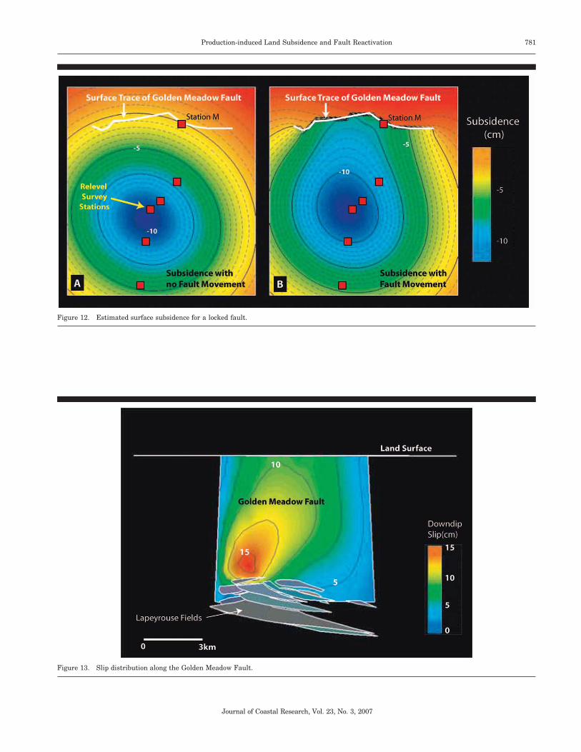
To estimate the maximum amount of compaction-inducedfault slip along the Golden Meadow Fault on surface subsi-dence, we assume the fault is traction-free. In other words,the Golden Meadow Fault can slip freely along its surfacewithout any restrictions. Figure 12 compares the effect of

780 Chan and Zoback
Journal of Coastal Research, Vol. 23, No. 3, 2007
Figure 10. The impact of rheology of the producing sand on the mag-nitude of the predicted surface subsidence.
Figure 11. A perspective view of the simplified Lapeyrouse Field and the Golden Meadow Fault created based on actual structural map. For colorversion of this figure, see page 675.
Golden Meadow Faults on surface subsidence. Note thatwhen the fault is locked (i.e., no displacement allowed), sur-face subsidence is controlled by reservoir compaction andyields a similar result to that of the Geertsma solution (Fig-ure 9A). The slight difference between the subsidence bowls
of Figures 9 and 12 is due to the shape of the reservoirs: allthe reservoirs are disc-shaped in the Geertsma solution whilethe reservoirs are irregular shaped in the numerical model.The occurrence of fault slip along the Golden Meadow Faultsignificantly alters the shape of the subsidence bowl espe-cially in the vicinity of the fault. The result shown in Figure12B is the maximum subsidence that can occur with the in-fluence of production-induced slip on the Golden MeadowFault. The slip distribution along the Golden Meadow Faultvaries spatially (Figure 13) due to the location of the reser-voirs and the shape of the fault. As the Golden Meadow Faultis modeled as a discontinuity in the elastic half space, defor-mation on the southern side of the fault will not translate tothe other side.
Comparing the predicted subsidence with the Geertsmamethod and the releveling line as in Figure 10, it is apparentthat the occurrences of compaction-driven fault slip along theGolden Meadow Fault changes the prediction of the verticalelevation change across the Lapeyrouse Field (Figure 14).Slip on the fault as a result of reservoir compaction providedextra vertical elevation change at Station M in the two casesexamined. For the elastic case, compaction-driven slip on thefault resulted in an additional 6 cm of elevation change atStation M; an additional 10 cm of elevation change is pre-dicted when the reservoirs are assumed to be totally uncon-solidated. Although the generalized compaction curve for un-consolidated sands provides larger estimated elevationchanges at Station M, it also overestimates the magnitude ofsubsidence in the center of the bowl.
781Production-induced Land Subsidence and Fault Reactivation
Journal of Coastal Research, Vol. 23, No. 3, 2007
Figure 12. Estimated surface subsidence for a locked fault.
Figure 13. Slip distribution along the Golden Meadow Fault.

782 Chan and Zoback
Journal of Coastal Research, Vol. 23, No. 3, 2007
Figure 14. Comparison of the predicted subsidence from the analyticaland numerical model with the observed subsidence measured by relev-eling.
DISCUSSION
In the analysis above, we considered only compaction andcompaction-related fault slip on the vertical elevation chang-es. Movement along regional growth faults was often ignoredin our study, PENLAND et al. (2002) report that 54% of wet-land loss in coastal Louisiana is related to land subsidencebut attributed only �1% of land loss to faulting (at a singlelocation: the Empire Fault in the Balize Delta). Conversely,GAGLIANO et al. (2003a,b) suggested that wetland loss wasprimarily the result of slip along regional growth faults thatare linked to the Oligocene-Miocene detachment surface atdepth of over 6 km. They also proposed that the massive landloss in the Terrebonne Trough was a result of movementalong the regional faults as a result of the subsurface saltmigration towards the Gulf of Mexico creating an onshoreextensional zone. Using aerial photographs, they identifiedmore than one hundred surface fault traces and concludedthat most of these fault traces are related to subsurfacefaults. Since most of the wetland loss located near the surfacetrace of these major faults, GAGLIANO et al. (2003a,b) con-cluded that fault movements along these growth faults havebeen occurring throughout the Quaternary and the suddenloss of wetland in the 1960s is just a result of sediment dep-rivation from the Mississippi River that accentuates surfacesignatures. They also suggested that fault movement alongthese active growth faults are episodic and are not uniformacross the fault regionally. Based on surface elevation chang-es, they concluded that the rate of vertical movement alongactive faults ranged from 1.5 mm/yr to 12.2 mm/yr. Unfor-tunately, these rates of movement are estimated without sep-arating effects from any other potential contributors to faultmovements, as a result, the fault movement rates proposedby GAGLIANO et al. (2003a,b) cannot be used as the back-
ground slip rate for the regional growth faults since they in-clude the combined effects of natural and human-inducedfault movement plus other mechanisms mentioned in previ-ous sections.
If the regional growth faults located in the coastal Louisi-ana are active and have natural episodic movements, it is fairto assume that fault movement occurs when the stress actingon the fault surface reaches a threshold stress. After faultslip, the accumulated stress is released and the fault is lockedagain until stress builds up to the threshold stress again.Since most growth faults in coastal Louisiana are active, therelatively large stress change induced by reservoir compac-tion due to hydrocarbon production may have an impact onthe frequency of slip along these growth faults (CHAN, 2004).
Although we have illustrated that fluid withdrawal cancause surface subsidence in the coastal wetlands, a numberof outstanding issues remain for future investigations:
(1) The predicted severity of compaction-induced subsidencein the area of the Lapeyrouse Field is 5–10 cm and highlylocalized over the field. The significance of this degree ofsubsidence for wetlands loss needs to be evaluated.
(2) The affect of production-induced fault slip at depth is toalter the shape of the subsidence bowl but not to signifi-cantly increase the maximum amount of subsidence. Thepoor fit of calculated subsidence to that apparently ob-served at station M, maybe the result of production to thenorth of the Golden Meadow fault or that the GoldenMeadow fault was naturally slipping in that area.
(3) We isolated the Lapeyrouse Field in this study to illus-trate the potential impact of hydrocarbon production onsurface subsidence in a local scale. To fully consider therole of hydrocarbon production from the many oil and gasfields in southern Louisiana, it will be necessary to eval-uate production-induced subsidence in the context of themultiple subsidence mechanisms that may be operativein the region.
(4) We illustrated that reservoir rock properties have an im-portant influence on the estimated amount subsidence. Itwould be valuable to conduct detailed rock mechanics ex-periments using representative samples from the reser-voirs in the region for future modeling.
It is important to have as much reliable data on verticalelevation changes in the region as possible to test varioushypotheses related to subsidence and wetlands loss. Suchdata could come from repeating surveys on the existing first-order level lines, from GPS or InSAR observations.
CONCLUSIONS
Utilizing both simple analytical and numerical models, therelationship between subsurface hydrocarbon production,land surface subsidence and fault reactivation has been in-vestigated in the Louisiana Coastal Zone. The LapeyrouseField located in the Terrebonne Parish was chosen as thestudy site due to its proximity to the Madison Bay land losshotspot and because it is bounded by a major regional growthfault in the north. Although there are some uncertainties as-

783Production-induced Land Subsidence and Fault Reactivation
Journal of Coastal Research, Vol. 23, No. 3, 2007
Figure 15. Sensitivity of the estimated subsidence due to uncertainties associated with different parameters for a shallow reservoir.
sociated with the severity of reservoir compaction estimateddue to massive fluid withdrawal in Lapeyrouse, the predictedsubsidence based on the Geertsma solution yields a compa-rable result to the measured elevation change from relevelingsurveys. The similarity between the simple Geertsma solu-tion and surface elevation measurements suggests that sub-surface hydrocarbon production has some influence on sur-face deformation. However, compaction-induced subsidencecannot fully capture the subsidence profile near the GoldenMeadow Fault. Using a more complicated numerical modelbased on Poly3D, we have demonstrated how reservoir com-paction may have encouraged slip along the Golden MeadowFault. The estimated elevation change as a result of compac-tion-induced fault slip only contributes about 35% of the ac-tual measured elevation change. It is uncertain if this misfitis caused by the uncertainties associated with the modeling(such as rock properties, reservoir geometries and interactionamong faults) or other human and/or natural processes. Re-gardless, using both simple analytical and numerical modelswith limited information, we have demonstrated that hydro-carbon production can introduce surface subsidence (and tosome extent fault slip) on the order of the observed surfaceelevation change locally.
Coastal wetland loss is a result of complicated interactionsbetween natural processes and human activities; it is difficultto isolate the impact of one specific mechanism from another.
The study presented in this paper suggests that production-induced land subsidence is one of the many mechanisms thatshould not be ignored when evaluating wetland loss in theLouisiana Coastal Zone. Detailed studies and modeling in-corporating other mechanisms are required in order to ac-curately assess the interaction between these mechanism andtheir cumulative contributions to surface subsidence. Whilewetland loss is widespread in southern Louisiana, hydrocar-bon production is capable of causing localized deformation inthe vicinity of the producing reservoirs. The degree to whichproduction from the many fields in the area has contributedto widespread wetlands loss is still unknown.
ACKNOWLEDGMENTS
The authors would like to thank Bob Morton for his insightfuldiscussion on the potential of hydrocarbon production in-duced land subsidence in Louisiana and his comments on themanuscript. We would also like to acknowledge Daniel Ash-ford from the Louisiana Department of Natural Resources,Ellen Mallman and Tricia Floria from Stanford University fortheir help at different stage of this project. We also like tothank Professors Gary Mavko, Amos Nur and Margot Ger-ritsen for their suggestions on the original manuscript.

784 Chan and Zoback
Journal of Coastal Research, Vol. 23, No. 3, 2007
Figure 16. Sensitivity of the estimated subsidence due to uncertainties associated with different parameters for a deep reservoir.
LITERATURE CITED
BARANOVA, V.; MUSTAQEEM, A., and BELL, S., 1999. A model forinduced seismicity caused by hydrocarbon production in the West-ern Canada sedimentary basin. Canadian Journal of Earth Sci-ences, 36, 47–64.
BARRAS, J.A.; BOURGEOIS, P.E., and HANDLEY, L.R., 1994. LandLoss in Coastal Louisiana: 1956–1990. National Wetlands Re-search Center Open File Report 94-01.
BOESCH, D.F.; JOSSELYN, M.N.; MEHTA, A.J.; MORRIS, J.T.; NUT-TLE, W.K.; SIMENSTAD, C.A., and SWIFT, D.J.P., 1994. Scientificassessment of coastal wetland loss, restoration & management inLouisiana. Journal of Coastal Research, Special Issue No. 20, 103p.
BRITSCH, L.D. and DUNBAR, J.B., 1993. Land loss rates: LouisianaCoastal plain. Journal of Coastal Research, 9, 324–338.
CAHOON, D.R.; DAY, J.W., JR., and REED, D.J., 1999. The influenceof surface and shallow subsurface soil processes on wetland ele-vation; a synthesis. Current Topics in Wetland Biogeochemistry, 3,72–88.
CHAN, A.W., 2004. Production-Induced Reservoir Compaction, Per-meability Loss and Land Surface Subsidence. Stanford, California:Stanford University, Ph.D. thesis, 176p.
CHAN, A.W.; HAGIN, P.N., and ZOBACK, M.D., 2004. Viscoplastic de-formation, stress and strain paths in unconsolidated reservoirsands (Part 2): field application using Dynamic DARS analysis.Presented at Gulf Rock 2004, the 6th North American Rock Me-chanics Symposium (NARMS), Houston, TX June 6–9, 2004.ARMA/NARMS 04-568.
COLAZAS, X.C. and STREHLE, R.W., 1995. Subsidence in the Wil-mington oilfield, Long Beach, California, USA. In: CHILINGARIAN,G.V. (ed.), Subsidence due to Fluid Withdrawal. Amsterdam: El-sevier Science, pp. 285–336.
COLEMAN, J.M. and ROBERTS, H.H., 1989. Deltaic coastal wetlands.Geologie en Mijnbouw, 68, 1–24.
DAVIS, S.D.; NYFFENEGGER, P.A., and FROHLICH, C., 1995. The 9April 1993 earthquake in south-central Texas: was it induced byfluid withdrawal? Bulletin of Seismological Society of America,85(6), 1888–1895.
DOSER, D.I.; BAKER, M.R., and MASON, D.B., 1991. Seismicity in theWar-wink gas field, Delaware Basin, West Texas, and its relation-ship to petroleum production. Bulletin of the Seismological Societyof America, 81(3), 971–986.
EASON, G.; NOBLE, B., and SNEDDON, I.N., 1954. On certain inte-grals of Lipschitz-Hankel type involving products of Bessel func-tions. Philosophical Transaction, Royal Society of London, A247,529–551.
EVANS, D.M., 1966. The Denver area earthquakes and the RockyMountain Arsenal Disposal Well. Mountain Geologist, 3, 23–36.
FARBER, S., 1987. The value of coastal wetlands for protection ofproperty against hurricane wind damage. Journal of Environmen-tal Economics and Management, 14(2), 143–151.
FRAZIER, D.E., 1967. Recent deltaic deposits of the Mississippi River;their development and chronology. Symposium on the geologicalhistory of the Gulf of Mexico, Antillean-Caribbean region. Trans-actions—Gulf Coast Association of Geological Societies, 17, 287–315.
GABRYSCH, R.K. and BONNET, C.W., 1975. Land-surface subsidencein Houston-Galveston region, Texas. Texas Water DevelopmentBoard Report 188, Austin: Texas, 19p.
GABRYSCH, R.K. and COPLIN, L.S., 1990. Land-surface SubsidenceResulting from Ground-water Withdrawals in the Houston-Gal-veston Region, Texas, Through 1987. U.S. Geological Survey Re-port of Investigations No. 90-01, Washington, D.C., 53p.

785Production-induced Land Subsidence and Fault Reactivation
Journal of Coastal Research, Vol. 23, No. 3, 2007
GAGLIANO, S.M.; KEMP, E.B., III; WICKER, K.M.; WILTENMUTH,K.S., and SABATE, R.W., 2003a. Neo-tectonic framework of south-east Louisiana and applications to coastal restoration. Transac-tions of the 53rd Annual Convention of the Gulf Coast Associationof Geological Societies and the Gulf Coast Section SEPM 2003,Baton Rogue, Louisiana, October 22–24, 2003, LIII, 262–272.
GAGLIANO, S.M.; WICKER, K.M.; WILTENMOUTH, K.S., and KEMP,E.B., III, 2003b. Active Geologic Faults and Land Change inSoutheastern Louisiana. Prepared for the U.S. Army Corps of En-gineers, New Orleans District, Contract No. DACW 29-00-S-0034.Coastal Environments, Inc. Baton Rouge, Louisiana 70802.
GEERTSMA, J., 1973. Land subsidence above compacting oil and gasreservoirs. Journal of Petroleum Technology, June 1973, 734–744.
GOMITZ, V.; LEBEDEFF, S., and HANSEN, J., 1982. Global sea leveltrends in the past century. Science, 215, 1611–1614.
GRASSO, J.R. 1992. Mechanics of seismic instabilities induced by therecovery of hydrocarbons. Pure and Applied Geophysics, 139, 507–533.
GRASSO, J.R. and WITTLINGER, G., 1990. Ten years of seismic mon-itoring over a gas field. Bulletin of the Seismological Society ofAmerica, 80(2), 450–473.
HAGIN, P.N. and ZOBACK, M.D., 2004.Viscous deformation of uncon-solidated reservoir sands (Part 2): Linear viscoelastic models. Geo-physics, 69, 742–751.
JAEGER, J.C. and COOK, N.G.W. 1969, Fundamentals of Rock Me-chanics. Methuen and Co. Ltd.: London, 515p.
KOOI, H., 1997. Insufficiency of compaction disequilibrium as thesole cause of high pore fluid pressure in pre-Cenozoic sediments.Basin Research, 9, 227–241.
KOOI, H., 2000. Land subsidence due to compaction in the coastal areaof The Netherlands: the role of lateral fluid flow and constraints fromwell-log data. Global and Planetary Change, 27, 207–222.
KOOI, H. and DE VRIES, J.J., 1998. Land Subsidence and hydrody-namic compaction of sedimentary basins. Hydrological Earth Sys-tem Science, 2, 159–171.
KUECHER, G.J.; ROBERTS, H.H.; THOMPSON, M.D., and MATTHEWS,I., 2001. Evidence for active growth faulting in the TerrebonneDelta Plain, South Louisiana: implications for wetland loss andthe vertical migration of petroleum. Environmental Geosciences,8(2), 77–94.
LOUISIANA COASTAL WETLANDS CONSERVATION AND RESTORATION
TASK FORCE AND THE WETLANDS CONSERVATION AND RESTO-RATION AUTHORITY, 1998. Coast 2050: Toward a SustainableCoastal Louisiana. Louisiana Department of Natural Resources:Baton Rouge, LA. 161p.
MCGARR, A., 1991. On a possible connection between three majorearthquakes in California and oil production. Bulletin of the Seis-mological Society of America, 81(3), 948–970.
MEREU, R.F.; BRUNET, J.; MORRISSEY, K.; PRICE, B., and YAPP, Y.,1986. A study of the microearthquakes of the Gobles oil field areaof Southwestern Ontario. Bulletin of the Seismological Society ofAmerica, 76(5), 1215–1223.
MORTON, R.A.; BUSTER, N.A., and KROHN, M.D., 2002. Subsurfacecontrols on historical subsidence rates and associated wetland lossin south central Louisiana. Gulf Coast Association of GeologicalSocieties Transactions, 52, 767–778.
MORTON, R.A.; PURCELL, N.A., and PETERSON, R., 2001. Field evi-dence of subsidence and faulting induced by hydrocarbon produc-tion in Coastal Southeast Texas. Gulf Coast Association of Geolog-ical Societies Transactions, 51, 239–248.
MORTON, R.A.; TILING, G., and FERINA, N., 2003. Primary causes ofwetland loss at Madison Bay, Terrebonne Parish, Louisiana.USGS Open File Report 03-60.
NEIGHBORS, R.J., 1981. Subsidence in Harris and Galveston coun-ties, Texas. In: JOHNSON, A.I. (ed.), Legal, Socio-Economic andEnvironmental Significance of Land Subsidence in the UnitedStates. American Society of Civil Engineering Journal of the Irri-gation and Drainage Division, 107(IR2), 161–174.
PAINE, J.G., 1993. Subsidence of the Texas coast: inferences fromhistorical and late Pleistocene sea levels. Tectonophysics, 222, 445–458.
PENLAND, S. and RAMSEY, K.E., 1990. Relative sea-level rise in Lou-
isiana and the Gulf of Mexico: 1908–1988. Journal of Coastal Re-search, 6, 323–342.
PENLAND, S.; RAMSEY, K.E.; MCBRIDE, R.A.; MOSLOW, T.F., andWESTPHAL, K.A., 1988. Relative Sea Level Rise and Subsidence inLouisiana and the Gulf of Mexico: Louisiana Geological Survey,Baton Rouge, Louisiana, 65p.
PENLAND, S.; WAYNE, L.; BRITSCH, L.D.; WILLIAMS, S.J.; BEALL,A.D., and BUTTERWORTH, V.C., 2000. Process classification ofcoastal land loss between 1932 and 1990 in the Mississippi RiverDelta Plain, Southeastern Louisiana. USGS Open File 00-418.
PENLAND, S.; WILLIAMS, S.J.; BRITSCH, L.D., and BEALL, A.D.,2002. Geologic classification of coastal land loss between 1932 and1990 in the Mississippi River Delta Plain, southeastern Louisiana.Transactions of the Gulf Coast Association of Geological Societies,52, 799–807.
PENNINGTON, W.D.; DAVIS, S.D.; CARLSON, S.M.; DUPREE, J.D., andEWING, T.E., 1986. The evolution of seismic barriers and asperi-ties caused by the depressuring of fault planes in oil and gas fieldsof south Texas. Bulletin of the Seismological Society of America,76, 939–948.
PRATT, W.E. and JOHNSON, D.W., 1926. Local subsidence of theGoose Creek oil field (Texas). Journal of Geology, 34(7), 577–590.
RALEIGH, C.B.; HEALY, J.H., and BREDEHOEFT, J.D., 1976. An ex-periment in earthquake control at Rangely, Colorado. Science, 191,1230–1237.
REED, D.J. and CAHOON, D.R., 1993. Marsh submergence vs. marshaccretion: interpreting accretion deficit data in coastal Louisiana.In: MAGOON, O.T., WILSON, W.S., CONVERSE, H., and TOBIN, L.T.(eds.), Coastal Zone ’93, Proceedings of the Eighth Symposium onCoastal and Ocean Management. New York: American Society ofCivil Engineers, pp. 243–257.
ROBERTS, H.H.; BAILEY, A., and KUECHER, G.J., 1994. Subsidencein the Mississippi River Delta; important influences of valley fill-ing by cyclic deposition, primary consolidation phenomena, andearly diagenesis. Forty-fourth annual convention of the Gulf CoastAssociation of Geological Societies, American Association of Petro-leum Geologists and the Forty-first annual convention of the GulfCoast Section of the Society of Economic Paleontologists and Min-eralogists, 44, 619–629.
SCARDINA, A.D.; NUNN, J.A., and PILGER, R.H., JR., 1981. Subsi-dence and flexure of the lithosphere in the North Louisiana saltbasin. EOS, Transactions, American Geophysical Union, 62(17),391.
SEGALL, P. 1985. Stress and subsidence resulting from subsurfacefluid withdrawal in the epicentral region of the 1983 Coalingaearthquake. Journal of Geophysical Research, 90, 6801–6816.
SEGALL, P., 1989. Earthquakes triggered by fluid extraction. Geolo-gy, 17, 942–946.
SEGALL, P. 1992. Induced stresses due to fluid extraction from axi-symmetric reservoirs. Pure and Applied Geophysics, 139, 535.
SHARP, J.M., JR., and HILL, D.W., 1995. Land subsidence along thenortheastern Texas Gulf coast: effects of deep hydrocarbon pro-duction. Environmental Geology, 25, 181–191.
STICKER, E.E., 1979. Geology and Reservoir Analysis of the Lapey-rouse Field, Terrebonne Parish, Louisiana. New Orleans, Louisi-ana. University of New Orleans, Master’s thesis, 68p.
SUHAYDA, J.N., 1987. Subsidence and sea level. In: TURNER, R.E.,and CAHOON, D.R. (eds.), Causes of Wetland Loss in the CoastalCentral Gulf of Mexico, Volume II: Technical Narrative. OCSStudy/MMS 87-0120. New Orleans: Louisiana: Minerals Manage-ment Service, pp. 187–202.
SUHAYDA, J.N.; BAILEY, A.; Roberts, H.H.; Penland, S., and KUECH-ER, G., 1993. Subsidence properties of Holocene sediments: SouthLouisiana. Coastal Zone ’93 New York, New York: American Soci-ety of Civil Engineering, 1215–1229.
SULAK, R.M., 1991. Ekofisk: the first 20 years. Journal of PetroleumTechnology, 43(10), 1265–1271.
SWANSON, R.L. and THURLOW, C.I., 1973. Recent subsidence ratesalong the Texas and Louisiana coasts as determined from tidemeasurements. Journal of Geophysical Research, 78, 2665–2671.
THOMAS, A.L., 1993. Poly3D: A Three-Dimensional, Polygonal Ele-ment, Displacement Discontinuity Boundary Element Computer
786 Chan and Zoback
Journal of Coastal Research, Vol. 23, No. 3, 2007
Program with Applications to Fractures, Faults and Cavities inthe Earth’s Crust. Stanford, California: Stanford University, Mas-ter’s thesis, 69 p.
VAN HASSELT, J.PH., 1992. Reservoir compaction and surface sub-sidence resulting from oil and gas production: a review of theoret-ical and experimental research approaches. Geologie en Mijnbouw,71, 107–118.
WHITE, W.A. and MORTON, R.A., 1997. Wetland losses related tofault movement and hydrocarbon production, Southeastern Texascoast. Journal of Coastal Research, 13, 1305–1320.
WHITE, W.A. and TREMBLAY, T.A., 1995. Submergence of wetlandsas a result of human-induced subsidence and faulting along theupper Texas Gulf Coast. Journal of Coastal Research, 11, 788–807.
WILLIAMS, S.J., PENLAND, S., and ROBERTS, H.H., 1994. Processesaffecting coastal wetland loss in the Louisiana deltaic plain. In:WILLIAMS, S.J. and CICHON, H.A. (eds.), Processes of Coastal Wet-lands Loss in Louisiana. U.S. Geological Survey Open File 940275,pp. 21–29.
YALE, D.P.; NABOR, G.W.; RUSSELL, J.A.; PHAM, H.D., and YOUSEF,M., 1993. Application of variable formation compressibility for im-proved reservoir analysis. SPE 26647.
ZOBACK, M.D.; CHAN, A.W., and ZINKE, J., 2001. Production-inducednormal faulting. Proceedings of the 38th US Rock Mechanics Sym-posium, DC Rocks 2001, Washington D.C., 7–10 July 2001, 157–163.
APPENDIX: THE GEERTSMA METHOD
For a disc-shaped reservoir of thickness H and radius R atdepth D, GEERTSMA (1973) estimated the effect of productionon surface subsidence based on a nucleus-of-strain concept.The reservoir is modeled as an ‘‘isolated volume of reducedpore pressure in a porous or non-porous but elastically de-forming half-space with traction free surface’’ (GEERTSMA,1973). Based on poroelastic theory, subsidence due to a uni-form pore pressure reduction, �PP, can be treated as the dis-placement perpendicular to the free surface as a result of thenucleus of strain for a small but finite volume, V, such that:
1 Du (r, 0) � � c (1 � �) �P V (A.1)z m P2 2 3/2 (r � D )
1 ru (r, 0) � � c (1 � �) �P V (A.2)r m P2 2 3/2 (r � D )
where cm is defined as the formation compaction per unitchange in pore-pressure reduction, and Poisson’s Ratio, �. As-suming both cm and � are constant throughout the entire halfspace, the amount of subsidence caused by a producing disc-shaped reservoir at depth can then be estimated by integrat-ing the nucleus-of-strain solution over the reservoir volume:
�
�D u (r, 0) � �2c (1 � �)�P HR J (R )J (r )e d (A.3)z m P � 1 00
�
�D u (r, 0) � �2c (1 � �)�P HR J (R )J (r )e d (A.4)r m P � 1 10
J0 and J1 are Bessel functions of the zero and first order re-spectively. EASON et al. (1954) evaluate integrals involving
products of Bessel functions. The general form of such inte-grals is noted as:
�
�ct �I(�, �; �) � J (at)J (bt)e t dt (A.5)� � �
0
Introducing the dimensionless parameters � � r/R and �D/R, Equations A.3 and A.4 can be simplified as
u (r, 0) � �2c (1 � �)�P HA(�, ) (A.6)z m P
u (r, 0) � 2c (1 � �)�P HB(�, ) (A.7)r m P
where A � RI(1, 0; 0) and B � RI(1, 1; 0). The solutions forA and B are linear combinations of the elliptic integrals ofthe first, second and third kind (EASON et al., 1954).
⎧ k 1� F (m) � � (p, k) � 1 (� � 1)0 024��⎪ k 1
A � I(1, 0; 0) � � F (m) � (� � 1)⎨ 04 2
k 1⎪� F (m) � � (p, k) (� � 1)0 024��⎩
(A.8)
1 12B � I(1, 1; 0) � 1 � k F (m) � E (m) (A.9)0 0� �[ ]2k��
where m � k2 � �/[(1 � �)2 � 2] and p � k2{(1 � �)2 � 2}/[(1 � �)2 � k2]. F0, E0, and �0 are the completed elliptic in-tegrals of the first, second kind, and the Heuman’s Lambdafunction, respectively.
Figures 15 and 16 demonstrate the sensitivity of the esti-mated subsidence due to uncertainties associated with R, D,cm, and �. Figure 15A shows that a 10% change in the radiusof the disc-shaped reservoir could yield a 20% uncertainty inthe estimated subsidence for a shallow reservoir (i.e., D � R).A 10% change in D could results in a 10% change in theestimated subsidence (Figure 15B). Uncertainty related toPoisson’s Ratio is relatively insignificant, but the estimatedsurface subsidence appears to be directly proportional to theuncertainty associated with compressibility (Figures 15C and16C). However, if the reservoir is significantly deeper (i.e., D� 10R), the impact of the size of the disc on surface subsi-dence is less than 2% (Figure 16A).
As Geertsma noted, rate and degree of pore pressure re-duction in any gas reservoir depends on the permeability dis-tribution within the reservoir, locations of the wells and theproduction rate. The analytical solution presented byGEERTSMA (1973) is limited to a disc-shaped reservoir. How-ever, the Geertsma method could still be used for an irregu-lar-shaped reservoir by replacing integration to summationof the effect of nuclei of strain over the reservoir volume.