the role of ship based measurements in the satellite calibration … · istituto di scienze...
TRANSCRIPT

The role of ship based
measurements in the satellite
calibration and validation
activities: the CNR experience
R. Santoleri
Istituto di Scienze dell’Atmosfera e del Clima –Roma
Via del Fosso del Cavaliere, 100 – 00133 Roma

Ocean Processes & Observing Systems

Satellite Role in Ocean Monitoring & CNR
mission
CNR objectives in the framework of the
European Effort :
Operational: develop a satellite operational
observing system able to provide high quality
near real-time, long term, synoptic global
observation of the ocean essential variable
(EOV). Contribute to the European
Copernicus Marine Enviromemental
monitoring Service
Scientific: assess the marine ecosystem state
and define the short and long term variability
circulation and primary production
Satellite is an essential component of
Ocean Observing System.
The only real avenue to
global coverage at high space and
time resolution. Satellite data
essential to constrain ocean models,
used for assimilation, forcing &
validation.
Satellites provide key
parameters: :
Sea Surface Height
Sea Surface Temperature
Ocean Colour
Sea Ice
Winds

CMEMS:Copernicus Marine
Environmental Service
4 THEMATIC ASSEMBLY CENTRES:
7 MONITORING AND FORECASTING CENTRES
Objective: European service providing every day information on the physical and ecosystem state of the oceans and European regional seas
14 MAIN OPERATORS for the main service functions
CNR leading OCTAC & contributing to OSITAC

CMEMS OC TAC: Architecture
CNR leads the OCTAC, European Ocean Colour component within the CMEMS.CMEMS provide NRT and reprocessed OC data global ocean and the EuropeanRegional Sea. Product quality information available for all products. Theproduct accuracy assessment strongly depends on high quality in situ data.

Copernicus Marine Enviromental Service
An integrated information
OPERATIONAL OCEANOGRAPHY BUILT
UPON MULTIPLE SOURCES OF INFORMATION
OBSERVATIONS
AND MODELS
PHYSICS AND
BIOGEOCHEMISTRY
REAL-TIME AND
REANALYSES
REANALYSES
10 to 45 years
REAL-TIME
Daily, hourlyFORECAST
2 to 10 days
Registered users ~ 8000


Remote sensing output is affected by:
• Instrument degradation;
• Calibration uncertainties;
• ƒErrors/assumptions on retrieval model
In situ data are necessary to ensure that satellite
remotely sensed data are properly calibrated and
validated.
Satellite data calibration
and Validation:
Research Cruises are unique mean to acquire
CAL/VAL measurements

In situ Fiducial Reference Measurements (FRM) are an essential for satellite mission calibration and validationResearch Cruises are cruicial to acquire FRM.

Mediterranean Ocean Color
Bio-optical DATA SETS
Annual Mediterranean cruises for Satellite OC CAL/VAL:organized by CNR-ISAC since 1997 in the framework of National and
International Projects
Bio-optical measurements: 769 in-water profiles of:
•downwelling irradiance (Ed)
•upwelling radiance (Lu)
•downwelling radiance (Eu)
•IOPs
•Chl profiles concurrently with in-water optical cast

FRM Bio-optical data: WMED-
BIOOPT
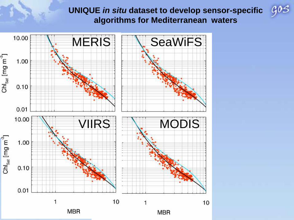
UNIQUE in situ dataset to develop sensor-specific
algorithms for Mediterranean waters
MERIS SeaWiFS
MODISVIIRS

Impact of the use of regional vs. global
algorithms to process satellite data
global algorithm
used by space
agency
Regional MED
algorithm developed
by CNR
Global – Mediterranean
Up to 100% differences!
Used by CNR to produce Ocean colour
products available from CMEMS

Chlorophyll Reference database
Since 2007 ISAC CNR organized annual Research cruise in collaboration with ENEA ZoologicalStation “Anton Dohrn” (SZN) to acquire in situ FRM chlorophyll data. This dataset is use toassess the quality of CMEMS products
20 Oceanographic cruises2710 stations
• Fluorescence profile• CTD profile
CNR Research cruises for Satellite CAL/VAL
20 Oceanographic cruises2710 stations

AQUA VIIRS
Multi MedCCI
Matchup & Statistics
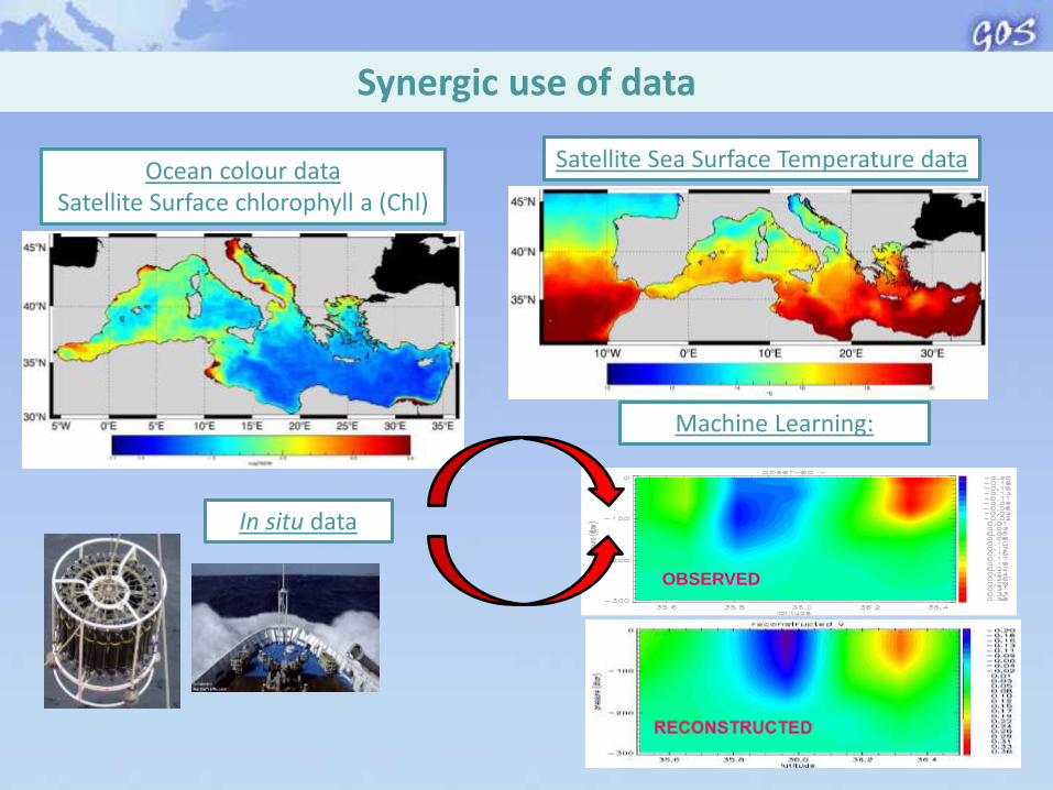
Synergic use of data
Ocean colour data Satellite Surface chlorophyll a (Chl)
Satellite Sea Surface Temperature data
In situ data
Machine Learning:
OBSERVED

Objectives :
• Regional algorithms for the TSM
• In situ mesurements for Cal/Val actvity (LISST and WetLab)
101
102
0
0.02
0.04
0.06
0.08
0.1
0.12
0.14
Diameters (m)
Vo
l. c
on
c. p
er
rin
g s
ize
(p
pm
m
-3)
0 0.5 1 1.5 2-70
-60
-50
-40
-30
-20
-10
0
Beam attenuation c (m-1
)
z (
m)
COSIMO 2015 Oceanographic Cruise
Rs 645 nm from L1B
MODIS product:
Sample strategy
based on NRT
satellite data
Variability of spatial patterns of total suspended matter during catastrophic flood
eventsObjectives :
• Quantify the TSM input from flood event
• Understand the geomorphologic inpact on the coasts
Satellite based TSM

Sentinel-3A Satellite
1. Sea Surface Temperature
2. Ocean Colour
3. Altimetry
Launched on
16 February
2016

Sentinel 3• The Copernicus Programme of the European Commission will
operate several satellite marine missions to provide synoptic,
global and regional aquatic bio-geochemistry information at
unprecedented scales.
• Sentinel-3A is the first operational mission in this context.
• The Sentinel-3 information will empower policymakers, public
authorities, the commercial sector and users worldwide who will
gain access to state-of-the art operational Copernicus Marine and
Climate Services using the measurement data.
To contribute to Sentinel-3
CAL/VAL activities CNR carried out
FRM measurements during this
summer and planned a CAL/VAL
Research cruise in 2017 as Italian
contribution S3VT.

CMEMS
SER
VIC
EDATA
DATA
USER
USER
PRIMI
APPLICATIONS:(eg. Oil Spill)
Copernicus marine service
From Core Service to downstream Service

PRIMI Project: Validation of satellite oil spill detection and fate
PRIMI project, funded by the Italian Space Agency (ASI) has implemented an
observation and forecast system to monitor marine pollution from hydrocarbon oil spills
(OS) in the Italian Seas.
Archive+ I/F
SAR
Optical
ForecastEO Data
Meteo-OceanData
Mail serverReports
Users Portal
Prime Contractor: E-GEOS
PI Scientifico : CNR-ISAC
Partners: CNR (ISAC, IAMC, ISMAR), ENEA, INGV, Un. PO
Partners: ACS, FlyBy, INNOVA

PRIMI CRUISE OBJECTIVES
1. To verify the accuracy of the oil slick detection by satellite
2. To verify the accuracy of the oil slick forecasting system
3. To release drifters into an oil slick and verify how they follow the slicks
4. To acquire in situ RADAR and LIDAR marine data in presence of oil spills
5. To collect oil spill water samples to analyze hydrocarbon composition, density and concentration
6. To acquire bio-ottical data of the area, for satellite algorithm validation (also in and out of OS)
7. To acquire surface mateo-marine data and R/V Urania navigation data for validationof SAR wind and ship detection products
8. To acquire hydrographic , biochemical and bilogical data of the area
The main cruise objective was to visit oil slicks detected by the PRIMI SAR
and Optical Observation Modules and whose displacement was predicted by
the PRIMI Forecast Module, in order to validate PRIMI system during
operation.
In particular:

I-SPHERE: Iridium
lagrangian drifters
SATLANTIC optical profiler
Rosette Water Sampler
(24 bottles)
& CTD
PRIMI Cruise: INSTRUMENTATION
ARGO lagrangian
drifters
RADAR
IN SITU
Drifter UNIBO
XBT
LIDAR

Workshop PRIMI (12 aprile 2011) - Il monitoraggio dallo spazio dell’inquinamento marino da idrocarburi tra presente e futuro
Oil Spill detection & Verification Strategy
OS SAR report received in
NRT on board, within two
hours from the satellite
overpass
SAR and VIS satellite
processed in NRT by PRIMI
system
RV Ship move to the area in which the OS was detected and forecast of the
OS board forecast of the oil spill drifi
ENVISAT IMP
27 ago. 2009 UTC 09:20
Check the OS in VIS images
ENVISAT WS 18-08-09 UTC 9:03
MODIS TERRA
18-08-09 UTC
10:05
Selection of OS to be verify in
situ

24
PRIMI Cruise: OS of Aug. 26-27, 2009, Sicily Channel
Example: OS in situ location of a slick detected in two successive ENVISAT ASAR and MODIS images
ASAR Aug. 26 200921:05 UTC
ASAR Aug. 27200909.20
MODIS TERRA Aug. 27200910:00 UTC
Slick SAR observation locations (yellow), prediction positions (red) and in situ location (green), drifter trajectory (red curve), final slick positions of Aug. 28 (tags at upper left).
2.0 and 2.3 g kg-1 of hydrocarbons were found in the samples

Thanks for the attention