the ultra participant information pack · butter, nutella, biscuits, jelly babies, brownies,...
TRANSCRIPT

23/09/2018
THE ULTRAPARTICIPANT
INFORMATION PACK
www.surreyhillschallenge.co.uk
2
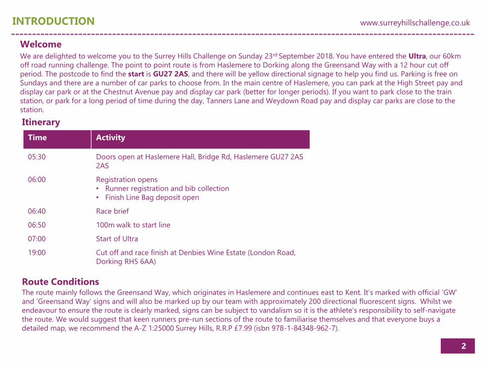
INTRODUCTION www.surreyhillschallenge.co.uk
WelcomeWe are delighted to welcome you to the Surrey Hills Challenge on Sunday 23rd September 2018. You have entered the Ultra, our 60km
off road running challenge. The point to point route is from Haslemere to Dorking along the Greensand Way with a 12 hour cut off
period. The postcode to find the start is GU27 2AS, and there will be yellow directional signage to help you find us. Parking is free on
Sundays and there are a number of car parks to choose from. In the main centre of Haslemere, you can park at the High Street pay and
display car park or at the Chestnut Avenue pay and display car park (better for longer periods). If you want to park close to the train
station, or park for a long period of time during the day, Tanners Lane and Weydown Road pay and display car parks are close to the
station.
Itinerary
Time Activity
05:30 Doors open at Haslemere Hall, Bridge Rd, Haslemere GU27 2AS
2AS
06:00 Registration opens
• Runner registration and bib collection
• Finish Line Bag deposit open
06:40 Race brief
06:50 100m walk to start line
07:00 Start of Ultra
19:00 Cut off and race finish at Denbies Wine Estate (London Road,
Dorking RH5 6AA)
Route ConditionsThe route mainly follows the Greensand Way, which originates in Haslemere and continues east to Kent. It’s marked with official ‘GW’
and ‘Greensand Way’ signs and will also be marked up by our team with approximately 200 directional fluorescent signs. Whilst we
endeavour to ensure the route is clearly marked, signs can be subject to vandalism so it is the athlete’s responsibility to self-navigate
the route. We would suggest that keen runners pre-run sections of the route to familiarise themselves and that everyone buys a
detailed map, we recommend the A-Z 1:25000 Surrey Hills, R.R.P £7.99 (isbn 978-1-84348-962-7).

3
THE ROUTE www.surreyhillschallenge.co.uk
Route Signage The route will be marked with orange fluorescent arrows and the existing signage of the Greensand Way.
The route is used by, but not limited to, horse riders, walkers and mountain bikers. Please be aware of other people whilst you are
running and be as polite and courteous as possible to them, making way when necessary. You do not have priority over any other users
out on the Greensand Way. All gates must be properly closed after you have gone through.
Other Users
• Fully Charged Mobile Phone including the numbers for the
Race Medic (TBA) and Event HQ (TBA)
• Water Bottles/Bladder capable of carrying a minimum of 1
litre.
• Survival Blanket: 1.4m x 2m minimum, provided at
registration
• Waterproof Jacket: Gore-tex or similar, we recommend it
having a minimum 10000 mm with sealed seams.
Kit List
• Whistle
• Warm Hat - Beanie Hat or Buff
• Gloves
• Base layer or fleece top
• Route Map - isbn 978-1-84348-962-7 A-Z 1:25000 Surrey Hills
We highly recommend that runners carry with them at all times the kit listed below:

4
THE ROUTE www.surreyhillschallenge.co.uk

5
GENERAL INFORMATION www.surreyhillschallenge.co.uk
Aid StationsThere are a total of 5 aid stations, including the finish location. The aid stations are well stocked with fluids and a variety of foods listed
below:
Aid Station 3 Alderbrook Road (GU6 8QU)Distance from start: 35.5km
Water, squash, coke, lemonade, High
Five Zero tabs, nuts, crisps, sandwiches,
sausage rolls, cheese, carrots, peanut
butter, Nutella, biscuits, Jelly Babies,
brownies, flapjacks, watermelon,
bananas
Spectator friendly
Aid Station 4 Leith Hill (RH5 6LU)Distance from start: 45.6km
Water, squash, coke, lemonade,
Gatorade, High Five Zero tabs, nuts,
crisps, sandwiches, sausage rolls,
cheese, carrots, peanut butter, Nutella,
biscuits, Jelly Babies, brownies,
flapjacks, watermelon, bananas
Spectator friendly
Aid Station 5 Coast Hill (RH5) No PostcodeDistance from start: 51.9km
Water, squash, coke, lemonade, High
Five Zero tabs, nuts, crisps, cheese,
carrots, peanut butter, Nutella, biscuits,
brownies, flapjacks, watermelon,
bananas
Finish Denbies Wine Estate (RH5 6AA)Distance from start: 60km
Water, drink and food available from
Denbies catering provision
Spectator friendly
Start Haslemere (GU27 2LA)Registration from 5am
Start 7am
Race brief 6:40am
Tea, coffee, water, biscuits
Spectator friendly
Aid Station 1 Boundless Road, Godalming (GU8) No PostcodeDistance from start: 13.3km
Water, squash, High Five Zero tabs,
nuts, biscuits, bananas, Jelly Babies
Spectator friendly
Aid Station 2 Upper Vann Lane (GU8 4ED)Distance from start: 22.6km
Water, squash, coke, lemonade, High
Five Zero tabs, nuts, biscuits, peanut
butter, Nutella, watermelon, bananas
Support CrewWe will look after you with fully stocked aid stations, medical support and plenty of volunteers to help you on your way so having your
own crew is not essential for the Surrey Hills Challenge. However, having friends and/or family cheering you on can provide a massive
psychological lift and means you can also ensure that you have the food and drink you prefer and a change of clothing if needed. We
have recommended which areas of the route are suitable for spectators in the Aid Station locations above. It’s important that supporters
follow all of the rules and regulations of the race, including the Race Rules and any supplementary instructions issued in pre-race memos
or at the race briefing. All supporters must willingly comply with all instructions from race staff and volunteers at all points along the trail
and its access routes, including parking regulations. If they do not then they run the risk of disqualification to their runner.

6
GENERAL INFORMATION www.surreyhillschallenge.co.uk
Cut-off times are for your own safety and all the participants taking place in the Surrey Hills Challenge. The times are listed below and
will also be on the Aid Station Charts. They will reflect the deadlines for LEAVING the aid station. If you return to an aid station after the
cut-off, you will be WITHDRAWN from the race. The cut-off times will be strictly enforced by the Aid Station Teams. Anyone leaving an
aid station after the cut-off time will be disqualified. This rule is for the safety of all participants. There is NO NEGOTIATION on the cut
off times.
IF YOU MISS THE CUT-OFF EVEN BY A MINUTE, YOU MUST STOP. If you miss a cut off you need to hand in your race number to the
aid station manager at which point you are officially withdrawn from the race. The aid station managers will try to relocate you to where
you need to go but please remember they are not under any obligation to do so. The sweeper bus will be able to collect you and take
you to the finish area.
Our first priority is to the runners still in the race and aid station personnel may well have dual duties at other aid stations to attend, once
their station closes. The sweeper bus will travel with the cut offs picking up dropped runners, but please be aware you may have to wait
for a considerable amount of time for the bus to leave, they will not do so until all runners are accounted for through that checkpoint.
Please respect our aid station volunteers, they are there of their own good will to support the event.
Cut Off
Haslemere Town Hall
Boundless Road
Upper Vann Lane
Alderbrook Road
Duke of Kent
School
Leith Hill Road
Coast Hill Denbies Wine Estate
CUT OFF TIME
09:30 11:10 13:35 15:35 17:15 19:30
Prizes
All finishers under the 12 hour cut off will receive a Surrey Hills Challenge medal and the male and female race winners of the Ultra will
also be awarded additional prizes marking their achievement. We are delighted to confirm the following prizes from:
• Aussie Grit Apparel (https://aussiegritapparel.com) can’t wait? Get 15% off and free P&P now using code challenge15
• Trek Hire UK (http://www.trekhireuk.com)
• Dogfit (https://dogfit.co.uk) can’t wait? Get 5% off now using code DFR5

7
GENERAL INFORMATION www.surreyhillschallenge.co.uk
Medical
The Surrey Hills Challenge is a challenging event and participation presents numerous medical risks, many of which can be extremely
serious or fatal.
Participation in this event is at the competitor’s own risk. At any one time during the race there will be ambulances and roving cars along
the course. There will also be a static medical team at the finish from the time of the first, to the time of the last finisher. In addition there
will be medical crews at some of the major aid stations.
It is important for each entrant to recognise the potential physical and mental stresses associated with such an event. Runners may be
subject to extremes of temperature, hyperthermia, dehydration, hypoglycaemia, hyponatremia, disorientation and mental and physical
exhaustion. We and the medical staff will strive to work with runners to ensure “safe passage” to the finish line. Ultimately runners must
understand their own limitations. Adequate physical and mental conditioning prior to the race is essential, if you have not been able to
prepare properly, do not attempt to run. Runners entering an ultra-distance trail event must understand that the trail is at times remote
and access via anything other than on foot is not possible. You must be capable of self-sufficiency for a prolonged period of time.
What to do in a Medical Emergency:
Call 07769 177759 at ANY time during the event. Save this number to your mobile phone.
This will put you through to the Event Medical Team Leader who will coordinate any response whilst giving advice. Our team will be
happy to talk you through Emergency Aid Procedures on the phone whilst they are on their way to you. If you are ill or injured or have
found someone who is and you need the medical team to attend your location, we will need the following information:
• Is the patient conscious and breathing?
• Your Phone Number (In case we need to call you back).
• Your name and / or Runner Number and that of the Casualty if Different.
• Your location (If unsure, please use feed-stations or road crossings as references).

8
RACE RULES www.surreyhillschallenge.co.uk
Race Rules
1. There will be no unofficial runners. Unofficial runners will be banned from taking part in future Surrey Hills Challenge races.
2. Each runner's bib number must be worn on the front of the body and must be easily visible at all times.
3. Runners must follow the marked trail/ course at all times.
4. Each runner must check in to all aid stations. DO NOT RUN PAST WITHOUT HAVING YOUR NUMBER TAKEN. You will be
disqualified if you are not registered at every aid station with your time.
5. Cut-off times will be strictly enforced. There are cut offs at every aid station. Runners reaching the finish after the final cut off will not
be listed as official finishers and will not be eligible for awards.
6. In addition to medical information provided by the runner during the online registration process, runners must fully disclose any
changes to existing medical conditions and all prescription medications being taken at race registration.
7. Runners compete in the Surrey Hills Challenge entirely at their own risk including, but not limited to road crossings, river crossings,
level crossings and all other hazards on the trail.
8. Littering of any kind will result in an immediate disqualification. Runners caught littering will be banned from all future events. Please
respect the natural beauty of our trails, littering will threaten the future of the race on the trails.
9. Any runner who is unable to finish the race must personally inform the aid station captain or the nearest marshal of their decision to
withdraw. HE OR SHE MUST HAND IN THEIR RACE NUMBER TO THE AID STATION MANAGER AT THE TIME OF WITHDRAWL. This serves
as an official notice of a runner’s withdrawal from the race. Runners who leave the course without turning in their number will be
classified as “lost,” initiating a search and rescue.
10. Pacers are not permitted at any stage of the run, please refer to point 1.
11. Runners are not to be accompanied by dogs at any time whilst on course, unless under the Canicross Rules and prearranged with The
Surrey Hills Challenge team.
12. Runners are advised to carry with them at all time the equipment Kist List outlined on page 3.

9
AUSSIE GRIT APPAREL https://aussiegritapparel.com

10
DOGFIT https://dogfit.co.uk

11
CJ’s AIM
CJ’s AIM will be offering massages in the Event Village
15 minutes for £10
Pre-bookings welcome
Taping will also be offered
Email [email protected] or text 07801 314281

12
SURREY HILLS FESTIVAL OF SPORT www.surreyhillsfestivalofsport.co.uk
About the Festival
The Surrey Hills Festival of Sport is set in the beautiful vineyards
of Denbies Wine Estate, Dorking on Sunday 23rd September
2018 open from 09:00 to 19:30 with main activities taking place
between 10:00 and 16:00.
The Festival is a FREE to attend event celebrating the Surrey Hills
Area of Outstanding Natural Beauty, a fantastic area for outdoor
activities, sport and exercise. Through participation and the
demonstration of all the different types of activities people can
get involved with, the Festival will showcase just how great and
versatile the Surrey Hills is.
From walking and running, horse riding and cycling to
orienteering and archery, woodland skills and climbing, as well
as showing how accessible the Hills are for everyone.
Top of the range sports retailers will also be demonstrating kit
and offering advice including Aussie Grit, Lululemon and Trek
Hire.
The very best of local food and drink will be served by Denbies.
The Festival has been developed to sit alongside the Surrey Hills
Challenge. All Challenges finish at the Festival creating a lively,
party atmosphere with plenty of activities for participants and
spectators to enjoy.
For more information visit www.surreyhillsfestivalofsport.com

13
ROUTE POINTS OF INTEREST www.surreyhillschallenge.co.uk
Points of Interest – Part 11. Haslemere - The town remained small and isolated until the 19th century. Old maps show clusters of houses only around the High
Street and St Bartholomew’s Church.
2. Town Hall - Originally built in the 17th century, the Town Hall was rebuilt in a similar style in 1814. It used to have arcades, with the
ground floor open.
3. High Street - In the High Street the Town House, with Doric doorcase, dates from 1725. Sir Edward Whymper, first to climb the
Matterhorn, once lived here.
4. Haslemere Educational Museum - Sir Jonathan Hutchinson, a distinguished surgeon at the London Hospital, founded this museum in
1888.
5. Church Hill house - The walls and gate piers of this 18th century house are listed monuments as well as the Queen Anne-style house
itself. Church Hill Gate was once the stables.
6. St Bartholomew’s Church - The church tower dates from the 13th century. The rest of the church was rebuilt in the late 19th century. A
window by Burne-Jones commemorates the poet Tennyson who lived on Blackdown one mile away.
7. The Hindhead Tunnel - The longest under-land road tunnel in England taking A3 traffic under Hindhead Commons and skirting the
edge of the Devil’s Punch Bowl. The Tunnel project has allowed the old A3 bottleneck to be closed and returned to nature, enabling the
reunification of the National Trust land either side, creating the largest heathland restoration project in the South East.
8. Devil’s Punch Bowl - This huge hollow has been formed over many thousands of years, by water seeping out from the spring line
between the Hythe Beds and the Atherfield Clay.
9. Hindhead Common - Exmoor ponies and Highland cattle have been introduced to graze the slopes and maintain the heathland as it
was created by grazing animals over 800 years ago.
10. Church of St Michael and All Angels, Thursley - In the churchyard you will find the stone erected in memory of the sailor murdered on
Gibbet Hill. Eight chest tombs recall local 18th century residents, more prosperous in their day than the sailor, but less well-known.

14
ROUTE POINTS OF INTEREST www.surreyhillschallenge.co.uk
Points of Interest – Part 2
11. Bowlhead Green - A small hamlet between the parishes of Witley and Thursley. Bowlhead Green has a superb collection of buildings,
including barn and carthouse, dating from the 16th to the 18th century.
12. Banacle Common - Also known as Bannicle Hill, the Common served as one of the Admiralty Semaphore hills for a signalling system
devised in 1816 and used between London and Portsmouth.
13. Sandhills - The artists Miles Burkett Foster and Helen Allingham were among the intelligentsia who discovered Sandhills in the late
19th century and settled here.
14. Wormley - The station, opened here on 24 January 1859 was known as Witley for Chiddingfold until 1947. The village grew further
from 1867, when King Edward’s School nearby was founded ‘for 240 destitute children of both sexes’.
15. Oakhurst Cottage - The late 17th century cottage, owned by the National Trust, survives as it was in the 19th century. It houses part
of the Gertrude Jekyll collection of West Surrey Bygones.
16. Hambledon Village Shop - Purchased by the Hambledon Village Trust in 2003, this shop is now run by the people of the village as a
Post Office, grocers and small tea-shop.
17. Malthouse Lane, Hambledon - In the process known as galleting, pieces of ironstone used to be inserted into the mortar in local
houses. Said to keep the Devil away, it really saved mortar and added strength.
18. Court Farm - The farm was first built in the 17th century. The granary, also with hung tiles, dates from the 18th century.
19. Lime Kiln - The lime kiln, long disused, was first built in the 18th century. Before the lime kiln was constructed, local people used to
dig marl from the ground to spread on the fields as fertiliser.
20. Burgate Hangar - The slopes of Burgate Hangar have been made steeper by landslips. They now provide a spectacular setting for
hanging beeches.
21. Markwick Lane - Old lanes leading from the clay valley to the north, over the high ground of the Greensand ridge and down to the
Weald were frequently cut deeply into the sandstone of the Hythe Beds.

15
ROUTE POINTS OF INTEREST www.surreyhillschallenge.co.uk
Points of Interest – Part 3
22. St Peter’s Church, Hascombe - In this church, rebuilt by Henry Woodyer in 1864, the chancel roof is designed as an upturned fishing
boat. A stained glass window depicting the patron saint continues the fishing theme.
23. Hascombe Village - The village pond has served as both fish pond and millpond in its time. Shown on maps as marshy land at the
beginning of the 20th century, it is now fully restored.
24. Hascombe Hill - Iron Age Celts built a fortified camp here towards the end of the 1st century BC. It had a single ditch and rampart
across a narrow neck of land and just one entrance.
25. Scotsland Farm - The catslide roof of the 17th century barn is one of the most prominent of its kind. Picturesquely named, the
catslide provided an economic way of covering an extension used to house animals.
26. A Greensand Way pioneer - One of the kissing gates at Plonks Farm has a plaque inscribed ‘Dedicated to Tony Parker, OBE, Ramblers
Association – Green Sand Way pioneer 19-08-1994
27. Wey and Arun Canal - The canal left the Wey Navigation at Shalford and rose 48 feet in six miles through seven locks to Cranleigh
before descending into West Sussex at Newbridge.
28. Shamley Green - The name of Shamley may come from Shamble Lane, referring to the shelf of land on which the village lies.
29. Winterfold Heath - The heath is common land managed by The Hurtwood Control Trust on behalf of the principal owners, the Bray
family who were given the land by Henry VII over 500 years ago. In the last century RA Bray, the Lord of the Manor of Shere granted the
public a ‘right to roam’, a pioneering example of a landowner welcoming the public onto his land to walk, ride or cycle.
30. Jelley’s Hollow - Traces of a possible Roman road have been found, running up the hollow towards Winterfold Heath. A road came
from Stane Street and passed the site of a Roman temple at Farley Heath.
31. Ewhurst Windmill - Probably the highest windmill in Surrey, this tower mill was first built in about 1840. Corn-milling ceased here
around 1885.
32 Duke of Kent School - Built in 1885, by Ernest George and Peto, the school still has tiles made by Dalton’s Tile
Works.

16
ROUTE POINTS OF INTEREST www.surreyhillschallenge.co.uk
Points of Interest – Part 4
33. Holmbury Hill - Not long before the Roman Conquest, Iron Age Celts settled on Holmbury Hill, building a fort that covered eight
acres. Roughly cleared hearths suggest they had to abandon the fort in haste.
34. Memorial Seat - The seat was erected in memory of Reginald and Jocelyn Bray (1869-1964) who gave the Hurtwood to the public for
‘air and exercise’.
35. Holmbury St Mary - The village grew up in late Victorian times, combining two small hamlets. St Mary’s Church was designed in
perpendicular style by G E Street, the architect who also designed the Law Courts in London.
36. Leith Hill Place Wood - Leith Hill Place Wood is one of the few areas where ancient semi-natural woodland has survived. Like other
woods along the scarp face it provides a habitat for rare birds.
37. Leith Hill Tower - Mr Richard Hull, who lived at Leith Hill Place, gained permission from Mr Evelyn of Wotton to build a tower as a
Prospect House in 1765. It was later raised to 1,029 feet. Thirteen counties may be seen from the top on a clear day and it’s the highest
point in southeast England.
38. The Duke’s Warren - Once heavily grazed, these slopes are now covered by secondary woodland. From the 1870s until the First World
War the slopes were planted with firs for commercial woodland.
39. Tilling Springs - The River Tillingbourne rises on the dip slope as springs emerge from the junction of the Hythe Beds and the
Atherfield Clay.
40. Broadmoor - Cottages were built here in the 1880s round a central reading room. Broadmoor became a popular halfway house for
tourists between Westcott and Leith Hill.
41. Tillingbourne Falls - A Dutch merchant named Jacobson built the ornamental waterfall around 1740 as part of the Evelyns’ garden
landscape scheme. It took its head of water from ponds at a mill upstream at Brookmill.
42. Dorking - Dorking became a market centre for outlying districts as early as Saxon times. In medieval times timber from the local
hillsides was transported through Dorking for use in London and other larger towns.
43. St Martin’s Church, Dorking - St Martin’s Church was built between 1868 and 1877 following a design by Hendy Woodyer, in late-
Gothic style.

23/09/2018
WE HOPE YOU ENJOY THE
BIGGEST SPORTING
CHALLENGE IN SURREY
AND HOPE TO SEE YOU IN 2019!
Tel: +44 (0) 1483 542221
General Enquiries:
Web:
www.surreyhillschallenge.co.uk
Address:
Surrey Hills Challenge
56 Dunsfold Park
Cranleigh
Surrey
GU6 8TB
Contact
TH
AN
K
YO
USurrey Hills Challenge
@SurreyHillsChallenge
SurreyHillsChallenge