the use of computational intelligence for precision spraying of … · 2017. 3. 2. · carlos –...
TRANSCRIPT
The use of computational intelligence for precisionspraying of plant protection products
Bruno Squizato Faiçal


SERVIÇO DE PÓS-GRADUAÇÃO DO ICMC-USP
Data de Depósito:
Assinatura: ______________________
Bruno Squizato Faiçal
The use of computational intelligence for precision sprayingof plant protection products
Doctoral dissertation submitted to the Instituto deCiências Matemáticas e de Computação – ICMC-USP, in partial fulfillment of the requirements for thedegree of the Doctorate Program in Computer Scienceand Computational Mathematics. FINAL VERSION
Concentration Area: Computer Science andComputational Mathematics
Advisor: Prof. Dr. Jó Ueyama
USP – São Carlos
January 2017
Ficha catalográfica elaborada pela Biblioteca Prof. Achille Bassie Seção Técnica de Informática, ICMC/USP,
com os dados fornecidos pelo(a) autor(a)
Faiçal, Bruno Squizato
F159t Utilizando a inteligência computacional para a
pulverização precisa de produtos fitofarmacêuticos /
Bruno Squizato Faiçal; orientador Jó Ueyama. – São
Carlos – SP, 2017.
115 p.
Tese (Doutorado - Programa de Pós-Graduação em
Ciências de Computação e Matemática Computacional)
– Instituto de Ciências Matemáticas e de Computação,
Universidade de São Paulo, 2017.
1. Deposition prediction. 2. Agricultural
spraying. 3. Precision agriculture. I. Ueyama, Jó,
orient. II. Título.
Bruno Squizato Faiçal
Utilizando a inteligência computacional para a pulverizaçãoprecisa de produtos fitofarmacêuticos
Tese apresentada ao Instituto de CiênciasMatemáticas e de Computação – ICMC-USP,como parte dos requisitos para obtenção do títulode Doutor em Ciências – Ciências de Computação eMatemática Computacional. VERSÃO REVISADA
Área de Concentração: Ciências de Computação eMatemática Computacional
Orientador: Prof. Dr. Jó Ueyama
USP – São Carlos
Janeiro de 2017


This work is dedicated to all the people who helped me get here,
but their stay on this earth did not have enough time to be in that moment with me.

ACKNOWLEDGEMENTS
First of all, I want to thank my wife Rafaela for supporting me in the most difficult and
delicate moments. With your presence, not always calm, but always positive and motivating, you
were my main force in this walk. You also gave me the gift of being the father of a wonderful
girl named Maria Julia. If today we can enjoy this achievement, surely you deserve all the
recognition of having been (and to be) essential to all of this.
I want to thank my parents Roberto and Cecília for their unconditional support and
contribute in many ways to this achievement. With you on my side I have been able to endure
this long and arduous struggle. Thank you for being wonderful parents.
I also owe special thanks to my father-in-law Rafael and my mother-in-law Sirley for
supporting me from the beginning and always believing in me.
I want to thank my great-uncle Júlio and my great-aunt Ruth (in memory) for believing
and me since I was a child. They took care of me as a son and I can say that I consider them my
adoptive parents. Love you!
Special thanks to my eternal teacher Olga. It was you who aroused my interest in research
and showed me the importance that support a teacher can make in our lives. You are my example
and I am proud to have you as my teacher. Thank you!
Victor, thanks for the lively conversations, moments of relaxation and true friendship.
With your serene and balanced way you showed me how good it is to be just what I am without
worrying about other people. I don’t will forget the affection you had with my “four-legged
children” (dogs) when I needed to be away or when I was present and you visited us. Thank you
my friend!
I thank my brother Roberto, my sisters-in-law Francielly and Gabriela and my nieces
Valentina, Anna Luiza and Jamile for the moments of relaxation and fun, which gave me strength
to continue my walk.
Special thanks to my teachers André Carvalho and Rodrigo Mello for the friendship,
patience and teachings that went beyond the classroom.
Thanks are directed to my advisor Jó Ueyama by all the help and attention directed me.
Thanks are also directed to the FAPESP and CAPES for the financial support provided
throughout the development of this thesis with the process (processes No. 2013/18859-8 and
DS-6706658/D).


“Resilience is the ability to recover from crisis situations and learn from it.
It is to have flexible mind and optimistic thinking,
with clear goals and the certainty that
everything will pass.”
(Unknown author)


ABSTRACT
FAIÇAL, B. S. The use of computational intelligence for precision spraying of plant protec-
tion products. 2017. 115 p. Doctoral dissertation (Doctorate Candidate Program in ComputerScience and Computational Mathematics) – Instituto de Ciências Matemáticas e de Computação,Universidade de São Paulo, São Carlos – SP, 2017.
Protection management with the aid of plant protection products makes it possible to carry
out pest control programs in agricultural environments and make them less hazardous for the
cultivation of products on a large scale. However, when these programs are put into effect, only
a small proportion of the sprayed products is really deposited on the target area while much
of it is carried to neighboring regions. The scientific literature includes studies on the use of
mathematical techniques to calculate the physical transformation and movement and provide
a deposition estimate of the product. On the basis of this prediction, it is possible to configure
a system which can allow the spraying to be carried out in normal weather conditions in the
region for a satisfactory performance, although these conditions can undergo changes and make
any statistical configuration unreliable. An alternative way of overcoming this problem, is to
adapt the spray elements to the meteorological conditions while the protection management is
being undertaken. However, the current techniques are operationally expensive in computational
terms, which makes them unsuitable for situations where a short operational time is required.
This thesis can be characterized as descriptive and seeks to allow deposition predictions to be
made in a rapid and precise way. Thus it is hoped that the new approaches can enable the
spray element to be adapted to the weather conditions while the protection management is being
carried out. The study begins by attempting to reduce costs through a computational model of
the environment that can speed up its execution. Subsequently, this computational model is used
for predicting the rate of deposition as a fitness function in meta-heuristic algorithms and ensure
that the mechanical behavior of the spray element can be adapted to the weather conditions while
the management is put into effect. The results of this approach show that it can be adapted to
environments with low variability. At the same time, it has a poor performance in environments
with a high variability of weather conditions. A second approach is investigated and analyzed for
this scenario, where the adaptation requires a reduced execution time. In this second approach, a
trained machine learning technique is employed together with the results obtained from the first
approach in different scenarios. These results show that this approach allows the spray element
to be adapted in a way that is compatible with what was provided by the previous approach in
less space of time.
Keywords: Deposition prediction, Agricultural spraying, Precision agriculture.

RESUMO
FAIÇAL, B. S. Utilizando a inteligência computacional para a pulverização precisa de
produtos fitofarmacêuticos. 2017. 115 p. Doctoral dissertation (Doctorate Candidate Programin Computer Science and Computational Mathematics) – Instituto de Ciências Matemáticas e deComputação, Universidade de São Paulo, São Carlos – SP, 2017.
O manejo de proteção com uso de produtos fitofarmacêuticos possibilita o controle de pragas
em ambientes agrícolas, tornando-o menos nocivo para o desenvolvimento da cultura e com
produção em grande escala. Porém, apenas uma pequena parte do produto pulverizado realmente
é depositado na área alvo enquanto a maior parte do produto sofre deriva para regiões vizinhas.
A literatura científica possui trabalhos com o uso de técnicas matemáticas para calcular a trans-
formação física e movimento para estimar a deposição do produto. Com base nessa predição é
possível configurar o sistema de pulverização para realizar a pulverização sob uma condição me-
teorológica comum na região para um desempenho satisfatório, mas as condições meteorológicas
podem sofrer alterações e tornar qualquer configuração estática ineficiente. Uma alternativa
para esse problema é realizar a adaptação da atuação do elemento pulverizador às condições
meteorológicas durante a execução do manejo de proteção. Contudo, as técnicas existentes são
computacionalmente custosas para serem executadas, tornando-as inadequadas para situações
em que é requerido baixo tempo de execução. Esta tese se concentra no contexto descrito com
objetivo de permitir a predição da deposição de forma rápida e precisa. Assim, espera-se que
as novas abordagens sejam capazes de possibilitar a adaptação do elemento pulverizador às
condições meteorológicas durante a realização do manejo de proteção. Este trabalho inicia com
o processo de redução do custo de execução de um modelo computacional do ambiente, tornando
sua execução mais rápida. Posteriormente, utiliza-se este modelo computacional para predição
da deposição como função Fitness em algoritmos de meta-heurística para adaptar o comporta-
mento do elemento pulverizador às condições meteorológicas durante a realização do manejo.
Os resultados desta abordagem demonstram que é possível utilizá-la para realizar a adaptação
em ambientes com baixa variabilidade. Por outro lado, pode apresentar baixo desempenho
em ambientes com alta variabilidade nas condições meteorológicas. Uma segunda abordagem
é investigada e analisada para este cenário, onde o processo de adaptação requer um tempo
de execução reduzido. Nesta segunda abordagem é utilizado uma técnica de Aprendizado de
Máquina treinada com os resultados gerados pela primeira abordagem em diferentes cenários. Os
resultados obtidos demonstram que essa abordagem possibilita realizar a adaptação do elemento
pulverizador compatível com a proporcionada pela abordagem anterior em um menor espaço de
tempo.
Palavras-chave: Predição da deposição, Pulverização agrícola, Agricultura de Precisão.


LIST OF ABBREVIATIONS AND ACRONYMS
ANN Artificial Neural Network
CI Computational Intelligence
CV Coefficient of Variation
EC Evolutionary Computing
GPS Global Positioning System
ML Machine Learning
PA Precision Agriculture
SI Swarm Intelligence
UAV Unmanned Aerial Vehicle
ULV Ultra-Low Volume
WSN Wireless Sensor Network


CONTENTS
1 INTRODUCTION . . . . . . . . . . . . . . . . . . . . . . . . . . . . 19
1.1 General Background . . . . . . . . . . . . . . . . . . . . . . . . . . . . 19
1.2 Motivation . . . . . . . . . . . . . . . . . . . . . . . . . . . . . . . . . . 22
1.3 Research Objective . . . . . . . . . . . . . . . . . . . . . . . . . . . . . 23
1.4 Structure of this thesis . . . . . . . . . . . . . . . . . . . . . . . . . . . 25
2 BACKGROUND . . . . . . . . . . . . . . . . . . . . . . . . . . . . . 27
3 VALIDATION OF THE PLATFORM THROUGH A CASE-STUDY 31
4 INVESTIGATION OF THE USE OF META-HEURISTIC ALGO-
RITHMS TO ADJUST THE SPRAY ELEMENT CONFIGURATIONS 45
5 EVALUATION OF THE EFFECTIVENESS OF ADAPTING TO
THE BEHAVIOR OF THE SPRAY ELEMENT . . . . . . . . . . . . 57
6 VALIDATION IN ENVIRONMENTS WITH A LOW VARIABILITY
IN THEIR WEATHER CONDITIONS . . . . . . . . . . . . . . . . . 65
7 AN INVESTIGATION OF HOW TO ADAPT THE SPRAY ELE-
MENT TO ENVIRONMENTS WITH A HIGH VARIABILITY IN
THEIR WEATHER CONDITIONS . . . . . . . . . . . . . . . . . . . 83
8 FINAL CONSIDERATIONS . . . . . . . . . . . . . . . . . . . . . . . 103
8.1 Conclusions . . . . . . . . . . . . . . . . . . . . . . . . . . . . . . . . . . 103
8.2 Plans for Future Work . . . . . . . . . . . . . . . . . . . . . . . . . . . 105
BIBLIOGRAPHY . . . . . . . . . . . . . . . . . . . . . . . . . . . . . . . . . . . 107
APPENDIX A DISSEMINATION OF THE RESULTS ACHIEVED IN
THIS THESIS . . . . . . . . . . . . . . . . . . . . . . . 113

19
CHAPTER
1
INTRODUCTION
1.1 General Background
The world population has increased rapidly and there has also been a sharp rise in the rate
of this growth. It is estimated that by the year 2100, there will be between 9.6 and 12.3 billion
people living on the planet (GERLAND et al., 2014). Among the various challenges posed by
this growth in population, there is an urgent need to produce and supply food for everybody
(JOHNSON, 2016). However, it is believed that in 2014, approximately 0.8 billion inhabitants of
the world did not have sufficient food and that the food deficit reached an order of 40 million
tons (MARSILY; RIO, 2016).
In light of this, the main exporting countries of agricultural products can be expected
(and have the opportunity) to increase their production, reduce the food deficit and supply food
for everybody. According to FAO Trade and Markets Division (2014), Brazil is one of the largest
producers and exporters of agricultural products in the world. This classification includes it in
the list of countries that have this responsibility.
An alternative way of boosting food production is to make already existing areas of
cultivated land more productive. For this reason, plant protection products (also known as
pesticides) are employed in agricultural management with a view to providing a less adverse
environment for the cultivation of products (WEISENBURGER, 1993; FERREIRA; OLIVEIRA;
PIETRO, 2009; DORNELLES et al., 2011).
In Brazil, Law 7.802, (11th July 1989) (LEI, 1989), defines plant protection products
(pesticides), as follows:
"Products and agents derived from physical, chemical or biological processes, that
are designed for use in the production sectors, storage facilities and for the benefit of
agricultural products, in pasturelands, the protection of forests, (native or planted)
20 Chapter 1. Introduction
and other parts of the ecosystem; and also for use in urban, hydric and industrial
environments, which result in altering the flora and fauna, with the aim of preserving
them from the harmful activities of living beings."
It should be stressed that the unsuitable use of these products, as a result of direct or
indirect contact can cause serious damage to people’s health. Contact with them can lead to a
wide range of illnesses including cancer, respiratory complications and neurological diseases
(WEISENBURGER, 1993). It is estimated that about 2.5 million tons of plant protection products
are employed around the world each year and this figure is rising (PIMENTEL, 1995; TARIQ et
al., 2007). Moreover, it is believed that, on average, less than 0.1% of this amount is enough to
control the pests in cultivated land.
This product is used in plantations by spraying the whole cultivated area. The agricultural
spraying can be defined as a measure to expel or release products on the crops in an agricultural
area (FERREIRA; OLIVEIRA; PIETRO, 2009). This activity is one of the main systems of
management and is aimed at protecting the crops against agricultural pests and other problems
(such as weeds and harmful insects in the crop fields).
Two methods are widely employed for the spraying of plant protection products in
extensive areas (DAVIS; WILLIAMS, 1990; PERECIN et al., 1999; DORNELLES et al., 2011),
namely (i) terrestrial and (ii) aerial . Different aspects of these have been fully investigated in the
scientific literature (WANG et al., 2016; SAHA; PIPARIYA; BHADURI, 2016; GREGORIO et
al., 2016; MINOV et al., 2016; JIAO et al., 2016; SALYANI; CROMWELL, 1992; GHATE;
PERRY, 1994), and include the following: the efficiency of the products employed, the resulting
environmental impact and the effectiveness of the equipment and techniques that are used.
In terrestrial spraying, a vehicle (usually a tractor) enters the plantation and carries out
spraying in the whole of the cultivated area (GHATE; PERRY, 1994; DAVIS; WILLIAMS, 1990;
SALYANI; CROMWELL, 1992). This method can only be undertaken with the aid of tracks
(which may have to be created) to allow the vehicle to pass through the whole stretch of land.
This direct contact between the spray vehicle and the land under cultivation leads to healthy
plants being trampled down. These factors (the presence of tracks inside the plantations and
harmful contact with healthy plants) lead to a reduction of agricultural production.
The other method involves aerial spraying with the use of an aircraft as a vehicle for
transporting the required spraying system . The plane must fly over the whole cultivated area
and release the product in the targeted regions, while seeking to cover the crops with the spray
(JIAO et al., 2016; DAVIS; WILLIAMS, 1990; XIANG; TIAN, 2011; HUANG et al., 2009;
SALYANI; CROMWELL, 1992). If this method is employed, there is no need for tracks inside
the plantation or any form of contact of the vehicle with it. However, there is a greater distance
from the point where the product is released (the spray nozzles) and the plantation than with the
terrestrial method and this causes drift.

1.1. General Background 21
The aircraft often employ an Ultra-Low Volume (ULV) system for the application of a
greater volume of pesticides in a more versatile manner than the traditional spraying systems,
when in ideal conditions (PIMENTEL, 1995). However, in this scenario, only a small amount of
the pesticide reaches the targeted crop field, while the rest is carried outside the targeted areas
by the weather conditions (PIMENTEL, 1995). The evidence of the plant protection products
leading to drift, is usually found at a distance of 48 to 800 m from the targeted field; however,
this distance can reach 5 to 32 km, if it is in the direction of the wind (PIMENTEL, 1995).
There has been a notable rise in the use of autonomous vehicles (regardless of whether
they are terrestrial or aerial) and these are aimed at increasing the precision of the activities
and the duration of the procedure, without affecting the length of time spent each day by the
operatives. These vehicles also help to reduce the number of failures caused by human error
because they are fitted with a Global Positioning System (GPS) which provides precise navigation
and prevents the workers from suffering fatigue as the result of a long day’s work. One of the
wide range of autonomous vehicles which is under investigation is the Unmanned Aerial Vehicle
(UAV) which is used for the spraying of plant protection products (QIN et al., 2016; PEDERI;
CHEPORNIUK, 2015; ZHU et al., 2010; HUANG et al., 2009). Currently, it is estimated that
approximately 40% of the rice fields in Japan are sprayed by means of these aircraft (PEDERI;
CHEPORNIUK, 2015). One of the benefits of these types of aircraft is that they are able to
strengthen environmental protection management because they do not have a pilot on board and
can be remotely controlled by a professional.
In both spraying methods (terrestrial and aerial), the distance between the spray release
bar and the plantation, means that there can be drift outside the targeted region which can cause
an overlay of the product on plantations which do not require coverage. For this reason, it is
essential to know (and be able to handle) the vehicle correctly, as well as the spraying equipment,
so that the product can be applied properly (FERREIRA; OLIVEIRA; PIETRO, 2009). For
example, the Coefficient of Variation (CV) is one of the instruments used to estimate the most
suitable distance between the nozzles in the spray bar. Different distances between these elements
can provide overlapping patterns of varied uniformity and this has a direct influence on the
variability of the coverage. There have been several studies that suggest different values for this
coefficient depending on the type of product being employed (PERECIN et al., 1998; PERECIN
et al., 1999; SMITH, 1992; WOLF; SMITH, 1979).
The distance between the spray bar and the plantation is not the only factor related to
the drift of the product. Several other factors influence the trajectories of the droplets before
they reach the plantation(SALYANI; CROMWELL, 1992; WANG et al., 2014; RU et al., 2014;
DORUCHOWSKI et al., 2013; NUYTTENS et al., 2011), such as the speed and direction of the
wind, humidity, temperature, the size of the droplets, the speed of the vehicle and the volume
being sprayed.

22 Chapter 1. Introduction
1.2 Motivation
Despite advances made by the scientific community, the problem of the drift of plant
protection products outside the region, remains one of the main challenges in agricultural spraying
(NUYTTENS et al., 2011; CUNHA, 2008; CUNHA; REIS; SANTOS, 2006; CUNHA, 2009),
since it is regarded as one of the main causes of environmental contamination by agricultural
products (FERREIRA et al., 2011). As a result, this issue has been the object of a number of
studies by the scientific community, which are all aimed at reducing the damage caused to the
flora and fauna and boosting the production of agricultural land (NUYTTENS et al., 2011;
DORUCHOWSKI et al., 2013; SALYANI; CROMWELL, 1992; GHATE; PERRY, 1994; JIAO
et al., 2016; MINOV et al., 2016; GREGORIO et al., 2016).
FRIEDRICH, RAETANO and ANTUNIASSI (2004) estimates that approximately 50%
of pesticide sprays are wasted because they are applied in an unsuitable way. CUNHA, TEIX-
EIRA and VIEIRA (2005) states that a good result in the spraying of plant protection products
(i.e. a low deposition rate), can only be achieved if one knows the nature of the product and
carries out practices that are suited to the products and crops that will be sprayed.
In an attempt to mitigate the harmful effects of these products and carry out spraying
with greater precision, several studies have been conducted with computational simulations and
mathematical models. The purpose of these is to estimate the movement and respective changes
of each of the droplets of the sprayed product. These studies have the potential to estimate the
spray drift in controlled environments (SALYANI; CROMWELL, 1992; DEVARREWAERE et
al., 2016; DORUCHOWSKI et al., 2013; BAETENS et al., 2007).
There are two approaches that stand out in this area (HALLMANN; SCHEURLEN;
WITTIG, 1993; BAETENS et al., 2007; DEVARREWAERE et al., 2016), namely those of: (i)
Euler and (ii) Lagrange. It should be noted that in some studies a hybrid Eulerian-Lagrange
approach is adopted which is based on a statistical description of the dispersion phase in terms of
a stochastic process. This is where the particle is attached in a Eulerian statistical representation
of the fluid transport phase (SUBRAMANIAM, 2013).
Although good results can be obtained through these approaches (GRIFOLL; ROSELL-
LLOMPART, 2012; GUO; FLETCHER; LANGRISH, 2004; NIJDAM et al., 2006a; NIJDAM et
al., 2006b), the models that are based on them are expensive to put into effect in computational
terms (GRIFOLL; ROSELL-LLOMPART, 2012). The reason for this is that these mathematical
models require complex calculations to be made for each droplet at every moment, until the
plantation is reached or some final state is satisfied (for example, the complete evaporation of the
droplet). As is well known, this approach leads to a huge number of calculations being produced
during the numerous iterations that are needed to reach a condition of closure, which causes a
considerable delay to the operation.
Owing to the computational costs of these approaches, caused by the number of calcula-

1.3. Research Objective 23
tions made by the mathematical models, it is not applicable them in real-world environments
when managing the cultivation. This is because the calculation of a particular area can only be
finalized after it has already been sprayed. For example, there is a clear need for autonomous
vehicles to be adapted to the environmental conditions while the product is being applied. In this
way, the vehicle can adjust the spraying configurations to the weather conditions with the aim of
reducing the errors in the deposition.
1.3 Research Objective
The aim of this thesis is to allow a rapid and efficient prediction of the deposition of plant
protection products. This is to ensure that they can be used during the protection management so
that the mechanical behavior of the spray element (i.e. the vehicle fitted with a spraying system)
can be adapted to the weather conditions with a view to reducing the drift of these products while
the crops are being sprayed. This is because the drift is mainly caused by unsuitable spraying
being carried out in an environment with adverse weather conditions. The spraying element must
be able to operate in a suitable way in adverse weather conditions to ensure precision. It should
be noted that since there are constantly shifting weather patterns in the environment, the spray
element must be able to determine the weather conditions and make constant adjustments during
the protection management so that it can act with greater efficiency.
The nature of the locality and the concentration of the spray product must be estimated
in a rapid and precise way for this adaptation to be feasible. The estimate of the deposition must
be carried out at great speed so that it can be put into effect during the activity. At the same time,
accuracy is an essential feature because it has a direct influence on the decisions made by the
system.
Computational Intelligence (CI) can be defined as a methodology for computing which
provides a system with the capacity for learning and dealing with new situations, since it has one
or more reasoning attributes such as generalizing, discovery, combination and abstraction. In
other words, CI includes practical adaptation and the self-organization of concepts, paradigms,
algorithms and implementations that can enable suitable activities to be carried out (i.e. intelligent
behavior) in complex and constantly shifting environments (EBERHART; SHI, 2011).
The use of CI concepts allows the computational system of the spray element to adapt
to shifting patterns in the environment which are constantly taking place. Thus the computa-
tional element must identify the weather conditions of a particular environment and adapt its
configurations so that the lowest possible rate of drift will occur.
The combination of the dynamic features of the weather conditions with the compu-
tational costs incurred for estimating the deposition of spray products, poses a considerable
challenge for this thesis. Initially, a trade-off was made to overcome this problem by seeking
acceptable solutions while undertaking the management. This process is carried out in the

24 Chapter 1. Introduction
maximum time possible (which is pre-defined) and in the end, the best solution that is found is
used. In other words, the cultivated land is divided into strips for spraying and these strips are
subdivided into regions of interest (referred to in this work as sub-area). While the spray element
operates in the sub-area, this subdivision allows the computational system to be more suitably
adapted to the nearest sub-area. This search is carried out while the whole of the current sub-area
is being sprayed and allows the configurations of the spray element to be updated in the period
of time preceding the beginning of the operation in the new sub-area.
A meta-heuristic algorithm is used for this method, together with a computational model
for management that is designed to seek solutions that allow an adaptation to be made involving
a reduction in the estimated error rate. The representation of this model is directed at the next
subarea that will be sprayed without the use of stochastic variables, since it is believed that
this is the most accurate comparison, of the solutions assessed by the meta-heuristic algorithm.
Moreover, the fitness function of each solution is calculated on the basis of the concentration of
the product deposited outside the targeted area, including the areas nearby.
The fitness function described here is based on the concept of a set of basic features
(JAKOBI; HUSB; HARVEY, 1995; GO; BROWNING; VELOSO, 2004), the minimum use of
which have an impact on the relationship between the real world and computed environment. In
other words, only factors of great significance are included in the design of the model. The use
of the minimum number of factors from the real world, reduces the use of computing resources
and speeds up the search for acceptable solutions.
A second approach investigated in this thesis adopts a previous approach to find solu-
tions (or rather, configurations for adaptation) for different weather conditions before the data
protection management system is put into effect. These solutions are employed as a knowledge
base for training an Artificial Neural Network (ANN) with the aim of provide replies similar to
those generated by the meta-heuristic algorithm. The ANN incurs lower computational costs
when it is being used during the management of the crops and this allows the configurations to
be updated in shorter spaces of time.
The results obtained from both approaches show that if the spray element is adapted to
the weather conditions, it will lead to an increase in the precision of the protection management,
and thus reduce the drift of plant protection products to neighboring areas. Both approaches
proved to be efficient for the purposes of this thesis and succeeded in adapting the mechanical
behavior of the spray element to the weather conditions during the spraying. However, the
second approach allows the adaptation to be faster and at the same time more efficient, during
the management which suggests that it is a more promising method for use in a real-world
environment.

1.4. Structure of this thesis 25
1.4 Structure of this thesis
This thesis is written as a collection of papers. All articles have the author of this thesis
as the first author and are originated from the studies carried out in this work.
Chapters of this thesis are structured in the following way: after this section, in Chapter 2,
the description of the studies for the development of originating articles in this thesis is presented.
Chapter 3 contains the article on the validation of the spray platform used as a case study in
this thesis. Research on possible approaches to adjust spray element settings starts in Chapter 4,
where the article that evaluates the feasibility of using meta-heuristics algorithms in this context
is presented. Subsequently, the paper presented in Chapter 5 proposed a system for adapting the
spray element configuration and assesses their effectiveness in spraying. In Chapter 6 (Article
under review), we conducted a thorough study to investigate the use of different meta-heuristic
algorithms in the previously proposed system. A second approach is investigated in Chapter 7
to achieve adaptation behavior more quickly than that provided by the prior approach. Finally,
Chapter 8 describes the conclusions reached after carrying out this thesis and makes suggestions
for further studies that can complete the work on this field.

27
CHAPTER
2
BACKGROUND
At the outset, the article with the title The use of unmanned aerial vehicles and wireless
sensor networks for spraying pesticides (FAIÇAL et al., 2014b) (see Chapter 3) is mentioned as
the point of departure for this research study. In this article, a platform is designed that consists
of a UAV and a Wireless Sensor Network (WSN) for spray products. The WSN is installed inside
the plantation in the form of a matrix and this will receive the plant protection products by means
of the spraying carried out by the UAV. During the whole procedure, the UAV maintains active
communication links with the WSN which is used to pick up information about the deposition of
the spray product and the weather conditions of the region (for example the speed and direction
of the wind). If there is an imbalance between the readings carried out by the pairs of sensor
nodes in the upper layer and the previously defined threshold, the computational system of the
UAV will adjust its route to the flight so that it can maintain the correct balance for the deposition
of the product. The published results show that the degree of precision achieved in the spraying
with the proposed platform is higher than the spraying carried out with a traditional model (and
without any adjustment to the route).
The study undertaken in this article is geared to validating the platform, as the starting-
point of the thesis. This platform is essentially designed to be autonomous so that it is able to
take previously-defined corrective measures . It should be stressed that the automaticity of this
platform derives from its capacity to carry out the spraying without being controlled by a human
being. However, the mechanical behavior of the platform does not allow it to adjust to alterations
in the weather conditions of the region. As already stated, this gap is effectively filled by this
thesis which uses this platform as a case study that can enable its methodology to be transferred
to other approaches.
As the research progressed, it was found that the image intensity to which the UAV
routes were adjusted, had an influence on the precision of the spraying. In other words, the image
intensity that allowed the route to be well adjusted to particular weather conditions, did not have
the same degree of efficiency in different situations. As a result, there was an investigation of the
28 Chapter 2. Background
use of meta-heuristic algorithms combined with the concepts of Evolutionary Computing (EC)
and Swarm Intelligence (SI) with a view to finding more efficient adaptive intensity corrections
of the route for the weather conditions. The article Exploiting Evolution on UAV Control Rules
for Spraying Pesticides on Crop Fields (FAIÇAL et al., 2014) (see Chapter 4), published the
initial results of this study, where the feasibility of using these techniques for this objective is
analyzed. This means determining if these techniques can converge and provide a satisfactory
response in a timely manner. Subsequently, the article Fine-tuning of UAV control rules for
spraying pesticides on crop fields (FAIÇAL et al., 2014a) (see Chapter 5) broadened the inquiry
and assessed the effectiveness of using meta-heuristic algorithms to find intensity corrections
of the route and thus provide greater precision in every kind of weather condition. The results
achieved show that the use of an adaptive intensity for the weather conditions led to more precise
spraying and reduced the amount of drift of the spray product to neighboring regions. These
results can be seen as strong indications that the adaptation of the mechanical behavior of the
spray element to the weather conditions, can bring about a more precise kind of protection
management.
In the work undertaken, there is also a description of the methodology employed for the
adjustment of the mechanical behavior of the spray element. A simplified computing model is
used for estimating the deposition of the spray product. The deposition is represented in a matrix,
the size of which is proportional to the targeted area of the product. The strip of land that the
UAV must fly over to carry out the spraying is divided into targeted sub-areas which are used
to make the adjustment. It should be emphasized that the adjustment is made in parallel with
the original operation of the platform. In view of this, only the methodology employed for the
recommended adjustment uses the view of the targeted subareas, whereas the UAV keeps to its
task of carrying out the spraying in a previously defined track.
The methodology for adjustment employs a computing model to estimate the deposition
of the plant protection products inside the next targeted sub-area, on the basis of the flight
parameters, the weather conditions and the dispersion model. This means that, while the UAV
sprays the region corresponding to a sub-area, the methodology of adjustment is employed with
the aim of improving the performance of the spray element for the next sub-area. At this stage,
a meta-heuristic algorithm interacts with the computing model to find an image intensity that
provides a greater degree of accuracy for the deposition of the product in the next sub-area. If
one kind of intensity proves to be more efficient, the configuration of the UAV is upgraded at
the time of transition between the sub-areas. In this way the mechanical behavior of the spray
element can be adjusted to the weather conditions collected by the sensors from the targeted
sub-area in the recent past.
It should be underlined that the track that is covered by each particle of the spray product
is calculated on the basis of a dispersion model implemented in the computing model. These
calculations are only applied to the particles that remain in the environment represented by the

29
computing model (which includes a 3-dimensional representation), until they reach the plantation.
This feature assists in reducing the computational costs that are required to estimate the extent
of the deposition. In addition, the computing model that is employed does not make use of
stochastic variables to make an exact comparison between the various image intensities that are
assessed.
This approach was broadened in the article: An adaptive approach for UAV-based
pesticide spraying in dynamic environments (FAIÇAL et al., 2016a) (see Chapter 6) which
is currently being revised, and which can be outlined as follows: (i) investigations with four
meta-heuristic algorithms (Simulated Annealing, Hill Climbing, Particle Swarm Optimization
and Genetic) which are aimed at finding a technique that shows the best results for making the
mechanical behavior of the spray element suitable for the weather conditions , (ii) a system is put
forward for implementing the methodology outlined in Faiçal et al. (2014a) and (iii) there is an
investigation of the possibility of putting this approach into effect in a computational component
that is fitted on board of the aircraft.
The configurations of the algorithms that were evaluated were defined by the GridSearch
technique with a view to reducing the possible interference caused by the empirical configuration
parameters. The GridSearch technique undertakes a search which is guided by predefined
parameters and a suitable configuration within the search space which is also predefined. On
making a determined convergence, the configuration stage is finalized and the algorithms are
evaluated with their respectively defined configurations, in an individual way. The configuration
for the PSO algorithm, set out in Faiçal et al. (2014a), was not recommended by the GridSearch
technique but was included in the experiments of this study, because it is concerned with a
solution that is found in the literature and employed as a basis for evaluation.
The results published in this article show that the GA achieved a more stable execution
than the other techniques (100% of convergence for an intensity range that ensured a lower error
rate). Although the proposed system was expensive to put into effect in the aircraft itself, the
ground control station can be used as a center for processing the way it is carried out. Despite
the fact that the results showed an increase in the precision of the spraying, this system is
ideally suited for environments where there is little variability in the weather conditions. This
means that this approach cannot lead to a satisfactory performance in environments where the
weather conditions are subject to constant alterations. In this scenario, the defined intensity
cannot be more suitable when the UAV begins the spraying in the next targeted sub-area, even if
meteorological information about the recent past is provided.
As a means of finding a possible way of overcoming this obstacle, the use of a trained
ANN was investigated with results (intensity corrections for the route) obtained from the meta-
heuristic algorithm in different weather conditions. This approach is described in the article
Fine-Tuning of UAV Control Rules for Spraying Pesticides on Crop Fields: An Approach for
Dynamic Environments (FAIÇAL et al., 2016b) (see Chapter 7). The reason why the ANN

30 Chapter 2. Background
technique was chosen for this investigation, is that it has a capacity for interpolating satisfactory
data. This allows appropriate intensities to be recommended for unknown weather conditions
(and not used during the training stage). The generation of the knowledge base and training stage
are carried out before the management protection begins. At the same time, the trained ANN is
used during the spraying to allow a faster execution than was provided by the previous approach.
The published results show that the trained ANN is able to recommend results that are
similar to those found in the meta-heuristic algorithm where there is less time for execution.
This mechanical behavior allows an intensity correction of the upgraded route to be constantly
maintained in environments where there are often changes in the weather conditions.
Finally, it is emphasized that the results obtained with this thesis were highlighted in the
article The use of autonomous UAVs to improve pesticide application in crop fields (FAIÇAL;
UEYAMA; CARVALHO, 2016) presented in the 1st Workshop on High Velocity Mobile Data
Mining (an event forming a part of the 17th IEEE International Conference on Mobile Data
Management), see Appendix A.

31
CHAPTER
3
VALIDATION OF THE PLATFORM
THROUGH A CASE-STUDY
The use of unmanned aerial vehicles and wireless sensor networksfor spraying pesticides
Bruno S. Faiçal a, Fausto G. Costa a, Gustavo Pessin b,⇑, Jó Ueyama a, Heitor Freitas a, Alexandre Colombo a,Pedro H. Fini a, Leandro Villas c, Fernando S. Osório a, Patrícia A. Vargas d, Torsten Braun e
a Institute of Mathematics and Computer Science (ICMC), University of São Paulo (USP), São Carlos, São Paulo, BrazilbVale Institute of Technology, Belém, Pará, Brazilc Institute of Computing (IC), University of Campinas, Campinas, São Paulo, BrazildRobotics Laboratory, School of Mathematical and Computer Sciences, Heriot-Watt University, Edinburgh, UKe Institute of Computer Science and Applied Mathematics, University of Bern, Bern, Switzerland
a r t i c l e i n f o
Article history:
Received 19 April 2013Received in revised form 15 January 2014Accepted 19 January 2014Available online 29 January 2014
Keywords:
ArchitectureUnmanned aerial vehiclesControl loopAgricultural applications
a b s t r a c t
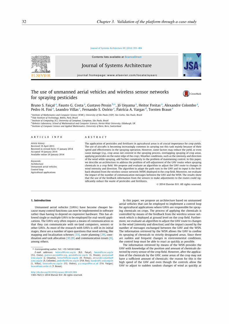
The application of pesticides and fertilizers in agricultural areas is of crucial importance for crop yields.The use of aircrafts is becoming increasingly common in carrying out this task mainly because of theirspeed and effectiveness in the spraying operation. However, some factors may reduce the yield, or evencause damage (e.g., crop areas not covered in the spraying process, overlapping spraying of crop areas,applying pesticides on the outer edge of the crop). Weather conditions, such as the intensity and directionof the wind while spraying, add further complexity to the problem of maintaining control. In this paper,we describe an architecture to address the problem of self-adjustment of the UAV routes when sprayingchemicals in a crop field. We propose and evaluate an algorithm to adjust the UAV route to changes inwind intensity and direction. The algorithm to adapt the path runs in the UAV and its input is the feed-back obtained from the wireless sensor network (WSN) deployed in the crop field. Moreover, we evaluatethe impact of the number of communication messages between the UAV and the WSN. The results showthat the use of the feedback information from the sensors to make adjustments to the routes could sig-nificantly reduce the waste of pesticides and fertilizers.
� 2014 Elsevier B.V. All rights reserved.
1. Introduction
Unmanned aerial vehicles (UAVs) have become cheaper be-cause many control functions can now be implemented in softwarerather than having to depend on expensive hardware. This has al-lowed single or multiple UAVs to be employed for real-world appli-cations. The UAVs very often require a means of communication sothat they can communicate with on-land computers, sensors orother UAVs. As most of the research with UAVs is still in its initialstages, there are a number of open questions that need solving, likemapping and localization schemes [33], route planning [29], coor-dination and task allocation [30,28] and communication issues [6],among others.
In this paper, we propose an architecture based on unmannedaerial vehicles that can be employed to implement a control loopfor agricultural applications where UAVs are responsible for spray-ing chemicals on crops. The process of applying the chemicals iscontrolled by means of the feedback from the wireless sensor net-work which is deployed at ground level on the crop field. Further-more, we evaluate an algorithm to adjust the UAV route to changesin the wind (intensity and direction) and the impact caused by thenumber of messages exchanged between the UAV and the WSN.The information retrieved by the WSN allows the UAV to confineits spraying of chemicals to strictly designated areas. Since thereare sudden and frequent changes in environmental conditions,the control loop must be able to react as quickly as possible.
The information retrieved by means of the WSN provides theUAV with knowledge of the position and amount of chemicals de-tected by every sensor of the crop field. However, after the applica-tion of the chemicals by the UAV, some areas of the crop may nothave a sufficient amount of chemicals; the reason for this is thehigh speed of the UAV and even though the controls allow theUAV to adjust to sudden random changes of wind as quickly as
http://dx.doi.org/10.1016/j.sysarc.2014.01.0041383-7621/� 2014 Elsevier B.V. All rights reserved.
⇑ Corresponding author. Tel.: +55 5432612484.E-mail addresses: [email protected] (B.S. Faiçal), [email protected]
(F.G. Costa), [email protected], [email protected] (G. Pessin), [email protected] (J. Ueyama), [email protected] (H. Freitas), [email protected] (A. Colombo), [email protected] (P.H. Fini), [email protected](L. Villas), [email protected] (F.S. Osório), [email protected] (P.A. Vargas),[email protected] (T. Braun).
Journal of Systems Architecture 60 (2014) 393–404
Contents lists available at ScienceDirect
Journal of Systems Architecture
journal homepage: www.elsevier .com/ locate /sysarc
32 Chapter 3. Validation of the platform through a case-study

possible, this might not be enough to maintain a perfect lane. As aresult, what happens is that we might have some clusters withoutthe correct amount of chemicals being dispersed. Hence, in this pa-per we also show how to build a chemical concentration map usingthe data provided by the WSN. The purpose of this is to show clus-ters where there is an insufficient application of chemicals and themap might be used to perform new UAV applications in designatedareas. We show how to build these maps using Instance-BasedAlgorithms [2] and Density-Based Algorithms [20].
This paper is an extended version of a previous study [10]. Itaims to describe the methodology that is employed in a more thor-ough way, conduct new experiments and discuss the new obtainedresults. Furthermore, we describe how a chemical concentrationmapping can be carried out by using the data obtained from theWSN and we present evaluations with real hardware, where wemeasure the communication time between the UAV and a groundsensor employing XBee-PRO Series 2.
This paper is structured as follows: in Section 2 we discuss re-lated work on mobile ad hoc network routing protocols and coop-erative sensing. Section 3 outlines the proposed method, bydescribing the proposed system architecture and the details of itsdevelopment. Section 4 describes the evaluation of all the con-ducted experiments, the first for the UAV route adjustment, thesecond for building the chemicals concentration maps (clusters)and the third for the evaluations employing real hardware. The fi-nal section concludes the paper and offers some futureperspectives.
2. Related work
2.1. Routing protocols
Mobile ad hoc network (MANET) routing protocols can be di-vided into a few main groups: (i) flat proactive routing, (ii) on-de-mand reactive routing, (iii) hybrid schemes, (iv) geographicalrouting and (v) opportunistic routing. Proactive (table-driven) adhoc routing protocols maintain their routing information indepen-dently of communication needs. Status update messages are sentperiodically or when the network topology has changed. Thus, asource node gets a routing path immediately if it needs one. Thisresults in low latency and makes them suitable for real-time traffic.When they use proactive routing protocols, nodes proactively up-date their network state and maintain a route regardless ofwhether data traffic exists or not. The main drawback of theserouting protocols is the high overhead they need to keep the net-work topology information up-to-date. All the nodes require a con-sistent view of the network topology.
Reactive (on-demand) routing only establishes routes if theyare required. This saves energy and bandwidth during periods ofinactivity. It should be noted that a significant delay may occuras a result of the on-demand route discovery. Compared to proac-tive ad hoc routing protocols, one advantage of reactive routingprotocols is the lower overhead control. Furthermore, reactiverouting protocols have better scalability than proactive routingprotocols in MANETs. One drawback is that reactive routing proto-cols may experience long delays for route discovery before theycan forward a data packet. Reactive protocols perform well inlight-load networks.
Geographical routing protocols assume that a source knows itsposition and can determine the position of the destination. More-over, each node knows its neighbors’ positions. In comparison withflooding-based approaches, geographical routing has a reducedoverhead for route discovery. Geographical routing protocols onlyrequire neighbor information containing their location to routepackets and do not need to maintain per-destination information.
Most geographical routing protocols use greedy forwarding asthe main method to select the next hop. In order to avoid dead-ends in the routing path, face-routing has been proposed to routearound a void.
Opportunistic routing [7,35,27] assumes that an end-to-endcommunication path may frequently be disrupted or may not existin a MANET at any time. The routing mechanism forwards the mes-sage towards the destination on a hop-by-hop basis and the nexthops are selected according to protocol-specific characteristics.This means that it is not essential to have a stable end-to-end con-nection from the data source to the destination. The packets areforwarded even though the topology is continuously changing.
2.2. Cooperative sensing
Wireless Sensor Networks are networks composed of severalwireless nodes. These nodes are often deployed near or inside envi-ronments or phenomena with the aim of sensing/obtaining infor-mation about it. The information is then routed to a commandcenter, where the data can be examined and appropriate actioncan be taken [9]. According to [3], those nodes are small embeddedsystems with the three following components: (i) mote, that is themain component of the sensor node, it is able of communicatewirelessly and should be programmable. Traditionally they arecomposed of a microcontroller, a radio and an energy source; (ii)a set of sensors, whose objective is to sense the environment andcollect data (i.e., temperature, humidity); and (iii) data interface,that can be a USB or a serial port, used to connect the mote to acomputer so that it can be programmed. Some motes allow thisby means of the wireless interface.
One major issue when dealing withWSN is the limited source ofenergy, which is normally provided by batteries. Although the bat-teries can be changed, this can be dangerous for human beings asthe sensor nodes might be installed in hazardous environments(i.e., volcanoes, chemical/nuclear affected areas). Furthermore,changing batteries is expensive (and requires both human andfinancial resources). Some techniques can be employed to increasethe lifetime of the nodes. The first of these is the on–off behavior,i.e., the sensor nodes turn off some components to save energy. Thebest component to turn off is the radio, because it is the compo-nent which uses most energy [24]. This procedure makes the sen-sor node unreachable for some time, so the communicationprotocols used by the WSN must be aware of it. The second tech-nique seeks to enhance the lifetime of the WSN by using limitedradios (low power and bandwidth) because it requires less energy.As a result, the nodes can only communicate with the nearestneighbors. Hence, to send any information from the WSN to abase-station, the message must be routed via several nodes. Thismethod is called multi-hop communication.
The cooperation of several types of nodes in a WSN application,including static and mobile nodes, can be seen in the work byErman et al. [14]. They have established a platform of heteroge-neous wireless sensor nodes with the objective of sensing andmonitoring fires in buildings. They propose to deploy nodes insidea building where each node is capable of detecting the temperatureof the room. When a fire is detected by the WSN, an UAV is calledto fly near the fire and to deploy more sensors, and thus gathermore information. When the fire-fighters arrive in the building,they wear a so-called Body Area Network so that they can receivethe information from the nodes and also collect informationrequired for the protection of the fire-fighters, such as bodytemperature and concentration of CO2 near their mask.
Another project that relies on the cooperation of different typesof nodes can be seen in the work by Valente et al. [31], where it isproposed the deployment of sensors in several vineyards to collectinformation about factors such as temperature and humidity.
394 B.S. Faiçal et al. / Journal of Systems Architecture 60 (2014) 393–404
33
Initially, the collected data were routed to a command center, butas the vineyards are more than 70 m away from each other, theycould not exchange the data. The authors tried to use more power-ful radios, but this led to excessive battery consumption and thelife-cycle of the WSN was drastically reduced. In light of this, thesolution was to use an UAV to fly over the vineyards and gatherdata when the farmer needs it. Following this, the UAV comes backto the command center and the data is sent to a Graphical UserInterface system where the farmer can visualize the informationabout the vineyards and determine the parameters of the wateringsystem.
3. Our approach to spraying pesticides
3.1. UAVs for agricultural application
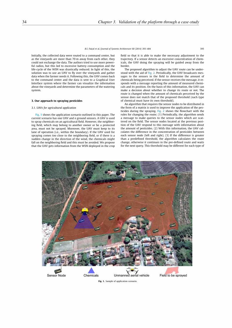
Fig. 1 shows the application scenario outlined in this paper. Thecurrent scenario has one UAV and n ground sensors. A UAV is usedto spray chemicals on an agricultural field. However, the neighbor-ing field, which may belong to another owner or be a protectedarea, must not be sprayed. Moreover, the UAV must keep to itslane of operation (i.e., within the boundary). If the UAV used forspraying comes too close to the neighboring field, or if there is asudden change in the direction of the wind, the chemicals mightfall on the neighboring field and this must be avoided. We proposethat the UAV gets information from the WSN deployed in the crop
field so that it is able to make the necessary adjustment to thetrajectory. If a sensor detects an excessive concentration of chem-icals, the UAV doing the spraying will be guided away from theborder.
The proposed algorithm to adjust the UAV route can be under-stood with the aid of Fig. 2. Periodically, the UAV broadcasts mes-sages to the sensors in the field to determine the amount ofchemicals being perceived. If the sensor receives the message, it re-sponds with a message reporting the amount of measured chemi-cals and its position. On the basis of this information, the UAV canmake a decision about whether to change its route or not. Theroute is changed when the amount of chemicals perceived by thesensor does not match that of the proposed threshold (each typeof chemical must have its own threshold).
An algorithm that requires the sensor nodes to be distributed inthe form of a matrix is used to improve the application of the pes-ticides during the spraying. Fig. 2 shows the flowchart with therules for changing the route; (1) Periodically, the algorithm sendsa message to make queries to the sensor nodes which are scat-tered on the field. The sensor nodes located at the previous posi-tion of the UAV respond to this message with information aboutthe amount of pesticides. (2) With this information, the UAV cal-culates the difference in the concentration of pesticides betweeneach sensor node (left and right). (3) If the difference is greaterthan a predefined threshold, the algorithm calculates the routechange, otherwise it continues in the pre-defined route and waitsfor the next query. This threshold may be different for each type of
Fig. 1. Sample of application scenario.
B.S. Faiçal et al. / Journal of Systems Architecture 60 (2014) 393–404 395
34 Chapter 3. Validation of the platform through a case-study
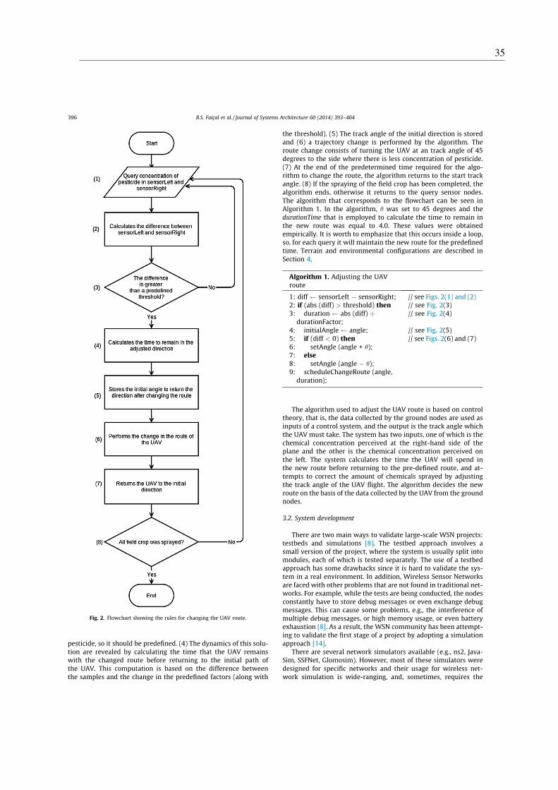
pesticide, so it should be predefined. (4) The dynamics of this solu-tion are revealed by calculating the time that the UAV remainswith the changed route before returning to the initial path ofthe UAV. This computation is based on the difference betweenthe samples and the change in the predefined factors (along with
the threshold). (5) The track angle of the initial direction is storedand (6) a trajectory change is performed by the algorithm. Theroute change consists of turning the UAV at an track angle of 45degrees to the side where there is less concentration of pesticide.(7) At the end of the predetermined time required for the algo-rithm to change the route, the algorithm returns to the start trackangle. (8) If the spraying of the field crop has been completed, thealgorithm ends, otherwise it returns to the query sensor nodes.The algorithm that corresponds to the flowchart can be seen inAlgorithm 1. In the algorithm, h was set to 45 degrees and thedurationTime that is employed to calculate the time to remain inthe new route was equal to 4.0. These values were obtainedempirically. It is worth to emphasize that this occurs inside a loop,so, for each query it will maintain the new route for the predefinedtime. Terrain and environmental configurations are described inSection 4.
Algorithm 1. Adjusting the UAVroute
1: diff sensorLeft � sensorRight; // see Figs. 2(1) and (2)2: if (abs (diff) > threshold) then // see Fig. 2(3)3: duration abs (diff) �
durationFactor;// see Fig. 2(4)
4: initialAngle angle; // see Fig. 2(5)5: if (diff < 0) then // see Figs. 2(6) and (7)6: setAngle (angle + h);7: else
8: setAngle (angle � h);9: scheduleChangeRoute (angle,
duration);
The algorithm used to adjust the UAV route is based on controltheory, that is, the data collected by the ground nodes are used asinputs of a control system, and the output is the track angle whichthe UAV must take. The system has two inputs, one of which is thechemical concentration perceived at the right-hand side of theplane and the other is the chemical concentration perceived onthe left. The system calculates the time the UAV will spend inthe new route before returning to the pre-defined route, and at-tempts to correct the amount of chemicals sprayed by adjustingthe track angle of the UAV flight. The algorithm decides the newroute on the basis of the data collected by the UAV from the groundnodes.
3.2. System development
There are two main ways to validate large-scale WSN projects:testbeds and simulations [8]. The testbed approach involves asmall version of the project, where the system is usually split intomodules, each of which is tested separately. The use of a testbedapproach has some drawbacks since it is hard to validate the sys-tem in a real environment. In addition, Wireless Sensor Networksare faced with other problems that are not found in traditional net-works. For example, while the tests are being conducted, the nodesconstantly have to store debug messages or even exchange debugmessages. This can cause some problems, e.g., the interference ofmultiple debug messages, or high memory usage, or even batteryexhaustion [8]. As a result, the WSN community has been attempt-ing to validate the first stage of a project by adopting a simulationapproach [14].
There are several network simulators available (e.g., ns2, Java-Sim, SSFNet, Glomosim). However, most of these simulators weredesigned for specific networks and their usage for wireless net-work simulation is wide-ranging, and, sometimes, requires the
Fig. 2. Flowchart showing the rules for changing the UAV route.
396 B.S. Faiçal et al. / Journal of Systems Architecture 60 (2014) 393–404
35

implementation of wireless network protocols and algorithms [22].In addition, in [22] it is possible to find out more about the featuresof these available simulators. In carrying out this project, the sim-ulator that is being used is OMNeT++.1
The OMNeT++ simulator is a discrete event simulator, based onC++ to model communication networks, multiprocessors and otherparallel and distributed systems. This simulator is open-source andcan be used for academic, educational and commercial purposes. Ithas been available for the Unix and Windows operating systemssince 1997 [32]. This simulator was not designed to work withina specific network, and as a result, it is used in several kinds of sim-ulations, such as networks with queues, wireless networks and P2Pnetworks [34]. Owing to its generic design, OMNeT++ has a num-ber of frameworks that have been established for specific net-works, such as MiXiM,2 a framework for wireless networkmodeling. This framework provides detailed models of wirelesschannels (e.g., fading), wireless connections, models for mobility,models for obstacles and several communication protocols, espe-cially for the MAC layer [19].
There are several systems that can be used to build autonomoushelicopters for agricultural applications. Currently, the most prom-ising one, is the Yamaha RMAX, which is designed for agriculturaluses, include spraying, seeding, remote sensing and precision agri-culture. This includes a liquid sprayer with a tank capacity of 8 li-tres (2 tanks) and a granular sprayer with a tank capacity of 13litres (2 tanks). Complete specifications can be seen in [36]. How-ever, the Yamaha RMAX is not fully autonomous yet, hence, studiesthat adopt intelligent and autonomous approaches are needed todevelop new versions. Another technical strategy that can beadapted to autonomous helicopters for agricultural applications,can be found in the work by Huang et al. [18], which examinesthe deployment of a spraying system for the Rotomotion UAVSR200 [25]. The Rotomotion UAV SR200 has up to 20 kg of payloadcapacity, although it does not have a spraying system off the shelf.In their work, the requirement was to spray 14 ha of land with asingle load, at a low volume spray rate (0.3 L/ha). Hence, 4.2 L ofchemical was needed to cover the 14 ha of land.
Furthermore, Ehmke [13] has written a featured research paperin which he describes several aspects of the task of employing un-manned aerial systems in agricultural fields, such as the necessaryskills, the costs involved and the privacy policy that is entailed inthe crop scouting and mapping by UAVs. As our aim is to studythe behavior of the UAV, in our approach, both of the above-citedUAVs can be employed. Naturally, there must be a fine-tuningphase involving the parameters of the algorithm, due to themechanical characteristics of each UAV. Furthermore, this fine-tuning phase should also take into account the type of crop beinghandled (soy, rice, corn, grapes, sugarcane) and the type of pesti-cide to be used.
3.3. Implementation details
The system implementation (currently in a simulation model)has been divided into two modules: (i) the Behavioral Module and(ii) the Chemical Dispersion Module. In the Behavioral Module wesimulate the communication between the WSN positioned in thefield and the UAV, using OMNeT++ with the MiXiM framework.The Dispersion Module was developed by means of Python3 andSDL4 library. The two modules run simultaneously, in an integratedway5 with socket-based communication. The Behavioral Module
sends the current position of the UAV (x; y; z) to the Dispersion Mod-
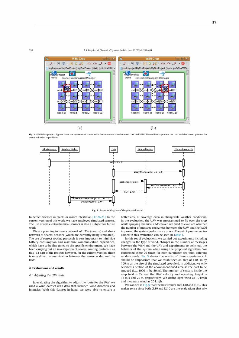
ule along with the track angle and speed of the UAV (h;v). Further-more, the wind modeling is carried out in the Behavioral Module;this emulates changes in wind direction and speed and providesinformation to the Dispersion Module about changes in the environ-ment. Fig. 3 shows an example of a sequence of scenes with the com-munication between UAV and WSN. In this example, there are 12nodes representing the sensors in the field and one node represent-ing the UAV.
The Dispersion Module calculates the fall of the chemicals, byobtaining the position and fall time of each drop. The WSN, in turn,determines the amount and position of the chemicals and returnsthis information to the Behavioral Module. Periodically, the UAVsends a broadcast message to the ground sensor nodes, requestingthe concentration in its area. The ground sensor nodes that receivethis message, connect to the Dispersion Module and request its con-centration using their positions (x, y, z) as parameters. In this way,they can respond by giving details of the concentration in this areato the UAV. By means of these response messages from the groundnodes, the UAV can call a decision manager, for instance, to com-pute its decision and then change its route if necessary. The chem-ical dispersion is based on a simplified pollutant model, whichconsiders (1) the vector of the initial velocity of the particle whenit is sprayed, (2) the vector of wind speed and (3) gravity. The inter-actions occur until the particles hit the ground. Nonetheless, inconducting a simulation of how chemical falls, we must not onlytake account of the height of the UAV, factors like wind speedand direction, temperature, humidity and the droplet size alsoinfluences the dispersion, as can be seen in the works by[5,11,16,12]. However, as we are working to achieve a path optimi-zation that can reduce the waste of chemicals, we believe the sim-ulation is satisfactory at this stage. After having a real sprayingmechanism, we believe we will be in a position to fine-tune someof the current parameters of the algorithm that adjust the path ofthe UAV to particular environmental conditions, weather patternsand types of chemical droplets.
Fig. 4 shows the proposed system sequence diagram and we cansee the relationship between the nodes. The first activity is windmanagement which sets the velocity and direction of the windthrough the setWind ðv ; hÞ function. This activity can occur atany time, by changing the wind properties in the Dispersion Mod-
ule. After this, while the UAV is moving through the field, it canuse the sprayChemicals function, and inform the Dispersion Module
of its position ðx; y; zÞ, velocity and track angle. With this informa-tion, the Dispersion Module is able to calculate where the chemicalparticles are going to be sprayed.
Regarding the ideal type of UAV, it must have the followingcharacteristics: (1) be capable of flying at �15 m/s, and (2) beequipped with a spray bar that can spray the pesticide. It mightbe an autonomous airplane or an autonomous helicopter, althoughin the real-world scenario we are working with helicopters, as canbe seen in Fig. 9. With regard to the UAV flying pattern, a tradi-tional technique is mimicked, in which the pilot performs thespraying in predefined tracks. The UAV flies from the beginningto the end of the track and across the field as many times as neededto cover all the tracks. However, in this work the results are basedon flights along a single track. With regard to terrain characteris-tics, the simulation environment considers the sensors deployedas a matrix (this can be understood with the aid of Fig. 8a). It is ex-pected to have random distributed sensors which will be a subjectfor future studies.
Currently there are some technologies that can identify chemi-cal levels in the air, soil or water. These technologies can calculatethe degree of moisture in terms of the percentage of a specificchemical composition in a given area. In addition to determiningthe degree of chemical concentration, the sensor nodes can be used
1 OMNeT++ Network Simulation Framework, http://www.omnetpp.org.2 MiXiM project, http://mixim.sourceforge.net.3 Python Programming Language, http://www.python.org.4 Simple DirectMedia Layer, http://www.libsdl.org.5 Simulation video available at http://youtu.be/4wFJZZEYAKM.
B.S. Faiçal et al. / Journal of Systems Architecture 60 (2014) 393–404 397
36 Chapter 3. Validation of the platform through a case-study
to detect diseases in plants or insect infestation [17,26,21]. In thecurrent version of this work, we have employed simulated sensors.The use of real electrochemical sensors is also a subject for futurework.
We are planning to have a network of UAVs (swarm) and also anetwork of several sensors (which are currently being simulated).The use of correct routing protocols is very important to minimizebattery consumption and maximize communication capabilities,which have to be fine tuned to the specific environment. We havebeen carrying out an investigation of several routing protocols, asthis is a part of the project; however, for the current version, thereis only direct communication between the sensor nodes and theUAV.
4. Evaluations and results
4.1. Adjusting the UAV route
In evaluating the algorithm to adjust the route for the UAV, weused a wind dataset with data that included wind direction andintensity. With this dataset in hand, we were able to ensure a
better area of coverage even in changeable weather conditions.In the evaluation, the UAV was programmed to fly over the cropwhile spraying chemicals. Moreover, we tried to evaluate whetherthe number of message exchanges between the UAV and the WSNimproved the system performance or not. The set of parameters in-cluded in this evaluation can be seen in Table 1.
In this set of evaluations, we carried out experiments includingchanges in the type of wind, changes in the number of messagesbetween the WSN and the UAV and experiments to point out thebehavior of the system while using the proposed algorithm. Weperformed these 70 times for each parameter set, with differentrandom seeds. Fig. 5 shows the results of these experiments. Itshould be emphasized that we established an area of 1100 m by100 m as the size of the simulated crop field. In addition, we onlyselected a section of the above-mentioned area as the part to besprayed (i.e., 1000 m by 50 m). The number of sensors inside thecrop field is 22 and the UAV velocity and operating height is15 m/s and 20 m, respectively. We define light wind as 10 km/hand moderate wind as 20 km/h.
We can see in Fig. 5 that the best results are CL10 and RL10. Thismakes sense since both CL10 and RL10 are the evaluations that rely
Fig. 3. OMNeT++ project. Figures show the sequence of scenes with the communication between UAV and WSN. The red blocks present the UAV and the arrows present thecommunication capabilities.
Fig. 4. Sequence diagram of the proposed model.
398 B.S. Faiçal et al. / Journal of Systems Architecture 60 (2014) 393–404
37

on more messages (every 10 s). RL10 is slightly better than CL10because it has random gusts of wind, which results in having nowind in some parts of the execution. Consequently, the chemicalis not affected by the wind the whole time and sometimes goes di-rectly toward the ground. The use of messages every 30 s shows animprovement with regard to the simulation without communica-tion and hence without using the proposed algorithm. In thesesimulations, the use of messages every 10 s allowed us to improvethe chemical dispersion in �14% compared with the sets with
messages every 30 s and in �27% compared with the sets withno messages at all.
We carried out a statistical analysis of the sets to determine ifthey can be considered to be distinct, and showed the efficiencyof the algorithm. First we verified the normal adequacy of thedistributions using the Shapiro–Wilk normality test. Most (8 of12) of the p-values are lower than 0.05, i.e., the hypothesis ofnormal adequacy is rejected with 95% of confidence. As most ofthe distributions are not accepted as normal, we carried out a
Fig. 5. Amount (%) of chemicals sprayed inside the boundary (results of 70 runs for each parameter set). The parameters can be seen in Table 1.
Fig. 6. A heat map to represent the chemicals sprayed on the crop at the end of the simulation. The red color represents no pesticide and green represents the mostconcentrated places. The thin black lines show the crop field that needs to have chemicals sprayed. (a) Evaluation without wind. This shows almost no chemicals outside thelane. (b) Evaluation with wind changes every 15 s and no adaptation in the UAV route – we can see that the wind makes the chemicals fall outside the boundary lane. (c)Evaluation with wind changes every 15 s and when the algorithm is used to adapt the UAV route – we can see that the algorithm adjusts the UAV by attempting to keep thechemicals within the boundary lane. (For interpretation of the references to colour in this figure legend, the reader is referred to the web version of this article.)
B.S. Faiçal et al. / Journal of Systems Architecture 60 (2014) 393–404 399
38 Chapter 3. Validation of the platform through a case-study

non-parametric test (PairwiseWilcox Test) which showed p-valueslower than 0.05 in all cases. This means that the algorithm is effec-tive in adjusting the route of the UAV to improve the chemical dis-persion. Fig. 6 shows the representation of the chemicals sprayedin the crop field in some of the evaluations. In Fig. 6c we can seehow the algorithm adjusts the UAV route and attempts to keepthe chemicals within the boundary lane.
4.2. Mapping the chemical concentration
As described earlier, the information retrieved by means of theWSN, provides the UAV with knowledge of the position and theamount of chemicals in every sensor of the crop field. However,after the application of the chemical by the UAV, some areas ofthe crop might not have a sufficient amount of chemicals; thismight occur because the UAV is going too fast and even thoughthe rules allow the UAV to adjust to highly random shifts of wind
direction as quickly as possible, it might not be as fast as necessary.As a result, what happens is that there might be some clusterswithout the correct amount of chemicals. Hence, if we are able tobuild a chemical concentration map6 using the data provided bythe WSN, we might use this map to show clusters where there isan insufficient application of chemicals.
At the end of the UAV spraying operation, we can build a com-plete map of the chemical concentration, as we have all the infor-mation about the position of the sensors and the amount ofchemicals perceived in the UAV memory. The crop field withchemical concentration can be represented as a 2D matrix(Fig. 8a). We represent this map as a heat map, i.e., the amountsof chemicals are represented between the colors red and green,green being the greatest amount.
Fig. 7. Steps for mapping the chemical concentration.
Fig. 8. (a) A crop field represented as a 2D matrix (heat map). A shift from red to green represents less to more perceived chemicals. Most of the area is in red because thesensors are scattered. As expected, the diagram shows a crop field with a non-uniform chemical spraying operation, caused by the highly randomwind used in the simulation.(b) Map after the application of the interpolation technique (instance-weighted nearest-neighbor algorithm). (c) Map after the application of the threshold value, whichdetermines the lowest amount of chemicals. (d) Cluster identification using the DBSCAN algorithm. (For interpretation of the references to colour in this figure legend, thereader is referred to the web version of this article.)
6 Source-code and data files used to the mapping scheme are available in http://goo.gl/b0ClX.
400 B.S. Faiçal et al. / Journal of Systems Architecture 60 (2014) 393–404
39
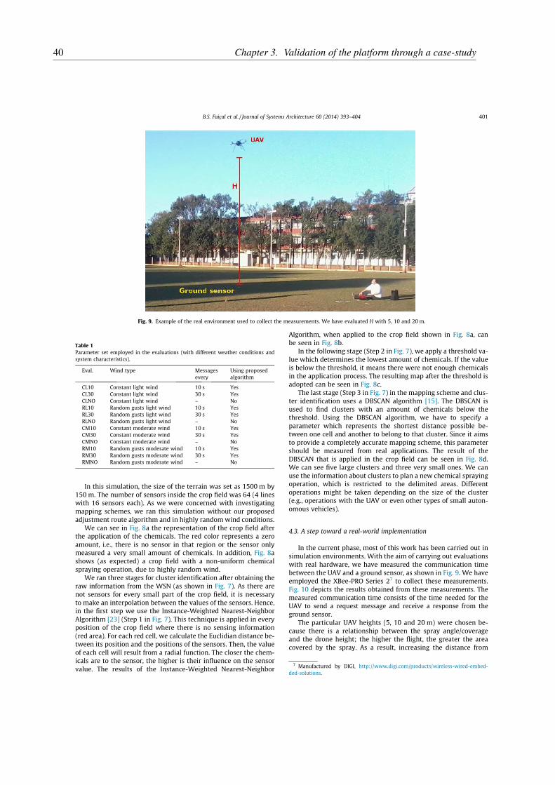
In this simulation, the size of the terrain was set as 1500 m by150 m. The number of sensors inside the crop field was 64 (4 lineswith 16 sensors each). As we were concerned with investigatingmapping schemes, we ran this simulation without our proposedadjustment route algorithm and in highly randomwind conditions.
We can see in Fig. 8a the representation of the crop field afterthe application of the chemicals. The red color represents a zeroamount, i.e., there is no sensor in that region or the sensor onlymeasured a very small amount of chemicals. In addition, Fig. 8ashows (as expected) a crop field with a non-uniform chemicalspraying operation, due to highly random wind.
We ran three stages for cluster identification after obtaining theraw information from the WSN (as shown in Fig. 7). As there arenot sensors for every small part of the crop field, it is necessaryto make an interpolation between the values of the sensors. Hence,in the first step we use the Instance-Weighted Nearest-NeighborAlgorithm [23] (Step 1 in Fig. 7). This technique is applied in everyposition of the crop field where there is no sensing information(red area). For each red cell, we calculate the Euclidian distance be-tween its position and the positions of the sensors. Then, the valueof each cell will result from a radial function. The closer the chem-icals are to the sensor, the higher is their influence on the sensorvalue. The results of the Instance-Weighted Nearest-Neighbor
Algorithm, when applied to the crop field shown in Fig. 8a, canbe seen in Fig. 8b.
In the following stage (Step 2 in Fig. 7), we apply a threshold va-lue which determines the lowest amount of chemicals. If the valueis below the threshold, it means there were not enough chemicalsin the application process. The resulting map after the threshold isadopted can be seen in Fig. 8c.
The last stage (Step 3 in Fig. 7) in the mapping scheme and clus-ter identification uses a DBSCAN algorithm [15]. The DBSCAN isused to find clusters with an amount of chemicals below thethreshold. Using the DBSCAN algorithm, we have to specify aparameter which represents the shortest distance possible be-tween one cell and another to belong to that cluster. Since it aimsto provide a completely accurate mapping scheme, this parametershould be measured from real applications. The result of theDBSCAN that is applied in the crop field can be seen in Fig. 8d.We can see five large clusters and three very small ones. We canuse the information about clusters to plan a new chemical sprayingoperation, which is restricted to the delimited areas. Differentoperations might be taken depending on the size of the cluster(e.g., operations with the UAV or even other types of small auton-omous vehicles).
4.3. A step toward a real-world implementation
In the current phase, most of this work has been carried out insimulation environments. With the aim of carrying out evaluationswith real hardware, we have measured the communication timebetween the UAV and a ground sensor, as shown in Fig. 9. We haveemployed the XBee-PRO Series 27 to collect these measurements.Fig. 10 depicts the results obtained from these measurements. Themeasured communication time consists of the time needed for theUAV to send a request message and receive a response from theground sensor.
The particular UAV heights (5, 10 and 20 m) were chosen be-cause there is a relationship between the spray angle/coverageand the drone height; the higher the flight, the greater the areacovered by the spray. As a result, increasing the distance from
Table 1
Parameter set employed in the evaluations (with different weather conditions andsystem characteristics).
Eval. Wind type Messagesevery
Using proposedalgorithm
CL10 Constant light wind 10 s YesCL30 Constant light wind 30 s YesCLNO Constant light wind – NoRL10 Random gusts light wind 10 s YesRL30 Random gusts light wind 30 s YesRLNO Random gusts light wind – NoCM10 Constant moderate wind 10 s YesCM30 Constant moderate wind 30 s YesCMNO Constant moderate wind – NoRM10 Random gusts moderate wind 10 s YesRM30 Random gusts moderate wind 30 s YesRMNO Random gusts moderate wind – No
Fig. 9. Example of the real environment used to collect the measurements. We have evaluated H with 5, 10 and 20 m.
7 Manufactured by DIGI, http://www.digi.com/products/wireless-wired-embed-ded-solutions.
B.S. Faiçal et al. / Journal of Systems Architecture 60 (2014) 393–404 401
40 Chapter 3. Validation of the platform through a case-study

the area where the pulverization is carried out, increases thedispersion of the pesticide. It should be emphasized that environ-mental conditions also affect the behavior (fall) of the chemicals.
We can notice that the average round trip time for 5, 10 and20 m is �0.04 s. Hence, we carried out a statistical evaluation ofthe times to check whether there was any significant differencebetween the 5 m, 10 m and 20 m sets.
Using the Shapiro–Wilk normality test we can observe thatthere is no evidence that the sets of 5 m and 20 m are normallydistributed, with 95% of confidence and the set of 10 m cannotbe rejected as a normal distribution, with 95% of confidence. Thep-values from the Shapiro–Wilk normality test, from 5 m, 10 mand 20 m, are 0.031, 0.056 and 0.006, respectively. Hence, as twoof the sets are considered not to be normal, we employ a non-parametric pairwise comparison. The pairwise comparison usingthe Wilcoxon rank sum test showed that there is no evidence ofany difference between the measurements, as all the p-values aregreater than 0.05. This evaluation has shown that there is no signif-icant difference between the times measured from 5 m, 10 m and20 m.
5. Conclusions
In this paper we have described an architecture based on un-manned aerial vehicles that can be used to implement a controlloop for agricultural applications, where UAVs are responsible forspraying chemicals on crops. The process of applying the chemicalsis controlled by means of the feedback from the wireless sensorsnetwork that is deployed at ground level on the crop field. Further-more, we have evaluated an algorithm to adjust the UAV route tochanges in the wind (intensity and direction) and the impact re-lated to the number of messages exchanged between the UAVand the WSN. Using the current terrain configuration, we foundthat the use of messages every 10 s does improve the spraying ofthe chemical in �14% compared to the sets with messages every30 s and in �27% compared to the sets with no messages at all.Moreover, we have also shown how to build a chemical concentra-tion map using the data provided by the WSN. The purpose of thiswas to show clusters with insufficient application of chemicalswhich might be used to perform new UAV applications in desig-nated areas. We described how to build these maps usingInstance-Based Algorithms and Density-Based Algorithms. Themeasured communication time between the UAV and the WSN,when the XBee-PRO Series 2 was employed, showed no significant
difference for height of 5 m, 10 m and 20 m. All the measured com-munication times are �0.04 s. However this appears to be veryshort, we have still not been able to assess the actual sensing ofthe chemicals, which needs to be addressed in the next stage ofthis research.
6. Future work
The next stages of this project will be as follows: (i) developingthe system using real hardware, addressing the reality gap in com-munications between the UAV and the WSN, the behavior of theUAV and the sensor capabilities, (ii) investigating the use of Evolu-tionary Techniques [4,1] to build (or tune) an autonomous set ofrules (i.e., the behavior of the UAV), and (iii) modeling the systemthrough a UAV swarm technique. As a final observation, since it isnecessary to improve the simulation environment (which allowsquicker and safer evaluations) other future work should seek toimprove the actual chemical dispersion, by also using the massof the particles, the viscosity of the chemicals and allowing a morerealistic interaction between these fluids.
Acknowledgments
The authors would like to acknowledge the financial supportgranted by CNPq and FAPESP to the INCT-SEC (National Instituteof Science and Technology – Critical Embedded Systems – Brazil),processes ID 573963/2008-8 and 08/57870-9. Also, the authorswould like to acknowledge FAPESP, process ID 2012/22550-0 andRNP (National Research Network) – CIA2-RIO. The third authorwould like to acknowledge the Capes Foundation, Ministry of Edu-cation of Brazil, process BEX 4202-11-2 and the eighth authorwould like to acknowledge CNPq, process ID 473493/2013-6.
References
[1] A. Abraham, C. Grosan, Engineering evolutionary intelligent systems:Methodologies, architectures and reviews, in: Engineering EvolutionaryIntelligent Systems, vol. 82 of Studies in Computational Intelligence,Springer, 2008, pp. 1–22.
[2] D.W. Aha, D. Kibler, M.K. Albert, Instance-based learning algorithms, Mach.Learn. 6 (1) (1991) 37–66.
[3] I.F. Akyildiz, M.C. Vuran, Wireless Sensor Networks, Wiley, 2010.[4] P. Angelov, D.P. Filev, N. Kasabov, Evolving Intelligent Systems: Methodology
and Applications, Wiley, 2010.[5] T. Arvidsson, L. Bergstrom, J. Kreuger, Spray drift as influenced by
meteorological and technical factors, Pest Manage. Sci. 67 (5) (2011) 586–598.
Fig. 10. Time of communication between a sensor ground and the UAV, using XBee-PRO Series 2.
402 B.S. Faiçal et al. / Journal of Systems Architecture 60 (2014) 393–404
41
[6] I. Bekmezci, O.K. Sahingoz, C. Temel, Survey flying ad-hoc networks (fanets): asurvey, Ad Hoc Netw. 11 (3) (2013) 1254–1270.
[7] S. Biswas, R. Morris, Opportunistic routing in multi-hop wireless networks,ACM SIGCOMM Comput. Commun. Rev. 34 (2004) 69–74.
[8] U.M. Colesanti, C. Crociani, A. Vitaletti, On the accuracy of omnet++ in thewireless sensornetworks domain: simulation vs. testbed, in: Proceedings of the4th ACM workshop on Performance evaluation of wireless ad hoc, sensor, andubiquitous networks, PE-WASUN ’07, ACM,NewYork, NY, USA, 2007, pp. 25–31.
[9] P. Corke, T. Wark, R. Jurdak, W. Hu, P. Valencia, D. Moore, Environmentalwireless sensor networks, Proc. IEEE 98 (11) (2010) 1903–1917.
[10] F. Costa, J. Ueyama, T. Braun, G. Pessin, F. Osorio, P. Vargas, The use ofunmanned aerial vehicles and wireless sensor network in agriculturalapplications, in: Geoscience and Remote Sensing Symposium (IGARSS), 2012IEEE, International, 2012, pp. 5045–5048.
[11] P. Donkersley, D. Nuyttens, A meta analysis of spray drift sampling, CropProtect. 30 (7) (2011) 931–936.
[12] G. Doruchowski, M. Roettele, A. Herbst, P. Balsari, Drift evaluation tool to raiseawareness and support training on the sustainable use of pesticides by driftmitigation, Comput. Electron. Agric. 97 (2013) 27–34.
[13] T. Ehmke, Unmanned aerial systems for field scouting and spraying, CropsSoils 46 (6) (2013) 4–9.
[14] A. Erman, L. Hoesel, P. Havinga, J. Wu, Enabling mobility in heterogeneouswireless sensor networks cooperating with UAVs for mission-criticalmanagement, Wireless Commun., IEEE 15 (6) (2008) 38–46.
[15] M. Ester, H. peter Kriegel, X. Xu, A density-based algorithm for discoveringclusters in large spatial databases with noiseo, in: Proceedings of 2ndInternational Conference on Knowledge Discovery and Data Mining, AAAIPress, 1996, pp. 226–231.
[16] B.K. Fritz, W.C. Hoffmann, N.B. Birchfield, J. Ellenberger, F. Khan, W.E. Bagley,J.W. Thornburg, A. Hewitt, Evaluation of spray drift using low-speed windtunnel measurements and dispersion modeling, in: ASTM Special TechnicalPublication, vol. 1527 STP, 2011, pp. 261–281.
[17] W. Gopel, T.A. Jones, M. Kleitz, I. Lundstrom, T. Seiyama, Sensors, Chemical andBiochemical Sensors, Wiley, 2008.
[18] Y. Huang, W. Hoffmann, Y. Lan, W. Wu, B. Fritz, et al., Development of a spraysystem for an unmanned aerial vehicle platform, Appl. Eng. Agric. 25 (6)(2009) 803–809.
[19] A. Köpke, M. Swigulski, K. Wessel, D. Willkomm, P.T.K. Haneveld, T.E.V. Parker,O.W. Visser, H.S. Lichte, S. Valentin, Simulating wireless and mobile networksin omnet++ the mixim vision, in: Proceedings of the 1st InternationalConference on Simulation tools and techniques for communications,networks and systems, ICST, 2008, pp. 71:1–71:8.
[20] H.P. Kriegel, M. Pfeifle, Density-based clustering of uncertain data, in:Proceedings of the eleventh ACM SIGKDD international conference onKnowledge discovery in data mining, KDD ’05, ACM, New York, NY, USA,2005, pp. 672–677.
[21] S. Li, A. Simonian, B.A. Chin, Sensors for agriculture and the food industry,Electrochem. Soc. Interface 19 (4) (2010) 41–46.
[22] C. Mallanda, A. Suri, V. Kunchakarra, S. Iyengar, R. Kannan, A. Durresi, S. Sastry,Simulating Wireless Sensor Networks with OMNeT++, 2005.
[23] T. Mitchell, Machine Learning, McGraw Hill, 1997.[24] D. Niculescu, Communication paradigms for sensor networks, Commun. Mag.,
IEEE 43 (3) (2005) 116–122.[25] Rotomotion, 2014. Rotomotion LLC, http://www.rotomotion.com/
prd_UAV_SR200.html.[26] L. Ruiz Garcia, L. Lunadei, P. Barreiro, I. Robla, A review of wireless sensor
technologies and applications in agriculture and food industry: state of the artand current trends, Sensors 9 (6) (2009) 4728–4750.
[27] R. Shah, A. Bonivento, D. Petrovic, E. Lin, J. van Greunen, J. Rabaey, Jointoptimization of a protocol stack for sensor networks, in: MilitaryCommunications Conference, 2004, MILCOM 2004, 2004 IEEE, vol. 1, 2004,pp. 480–486.
[28] S. Simi, R. Kurup, S. Rao, Distributed task allocation and coordination schemefor a multi-uav sensor network, in: Wireless and Optical CommunicationsNetworks (WOCN), 2013 Tenth International Conference on, 2013, pp. 1–5.
[29] P. Sujit, B. Hudzietz, S. Saripalli, Route planning for angle constrained terrainmapping using an unmanned aerial vehicle, J. Intell. Robot. Syst. 69 (1–4)(2013) 273–283.
[30] M. Tortonesi, C. Stefanelli, E. Benvegnu, K. Ford, N. Suri, M. Linderman,Multiple-uav coordination and communications in tactical edge networks,Commun. Mag., IEEE 50 (10) (2012) 48–55.
[31] J. Valente, D. Sanz, A. Barrientos, J. Cerro, Á. Ribeiro, C. Rossi, An air-groundwireless sensor network for crop monitoring, Sensors 11 (6) (2011) 6088–6108.
[32] A. Varga, The OMNET++ discrete event simulation system, in: Proceedings ofthe European Simulation Multiconference, SCS – European Publishing House,Prague, Czech Republic, 2001, pp. 319–324.
[33] F. Viani, P. Rocca, G. Oliveri, D. Trinchero, A. Massa, Localization, tracking, andimaging of targets in wireless sensor networks: an invited review, Radio Sci. 46(5) (2011).
[34] K. Wehrle, M. Gunes, J. Gross, Modeling and Tools for Network Simulation,Springer, 2005.
[35] C. Westphal, Properties of opportunistic and collaborative wireless meshnetworks, in: IEEE Global Telecommunications Conference, 2007, pp. 4828–4833.
[36] Yamaha, Yamaha Motor Co., 2014, http://rmax.yamaha-motor.com.au.
Bruno S. Faiçal is a Ph.D. student at the Institute ofMathematics and Computer Science of the University ofSao Paulo. He obtained an M.S. in Computer Science in2012 from the University of the Sao Paulo. At ICMC/USP,he has been working on several research projects rela-ted to wireless sensor networks and unmanned aerialvehicles.
Fausto G. Costa is a Ph.D. student at the Institute ofMathematics and Computer Science of the University ofSao Paulo. He obtained an M.S. in Computer Science in2013 from the University of the Sao Paulo. At ICMC/USP,he has been working on several research projects rela-ted to wireless sensor networks and time series analy-sis.
Gustavo Pessin is an Assistant Researcher at ValeInstitute of Technology. He obtained his Ph.D. degree inComputer Science at the Institute of Mathematics andComputer Science of the University of Sao Paulo, in2013. Currently, his research topics include robotics,wireless sensor network and machine learning tech-niques.
Jó Ueyama completed his Ph.D. in computer science atthe University of Lancaster (England) in 2006. He iscurrently an Associate Professor at the Institute ofMathematics and Computer Science, University of SãoPaulo (ICMC/USP). Jó is also a research fellow of theBrazilian Research Council (CNPq). His main researchinterest includes Computer Networks and DistributedSystems.
Heitor Freitas is a M.S. student at the Institute ofMathematics and Computer Science of the University ofSao Paulo. At ICMC/USP, he has been working on severalresearch projects related to unmanned aerial vehicleand wireless sensor networks.
B.S. Faiçal et al. / Journal of Systems Architecture 60 (2014) 393–404 403
42 Chapter 3. Validation of the platform through a case-study
Alexandre Colombo is a graduate student at the SãoCarlos School of Engineering of the University of SaoPaulo. At ICMC/USP, he has been working on severalresearch projects related to unmanned aerial vehicleand wireless sensor networks.
Pedro Henrique Fini is a Computer Engineeringundergraduate student at the Institute of Mathematicsand Computer Science (ICMC) and the São Carlos Schoolof Engineering (EESC) of the University of São Paulo(USP). At ICMC/USP, he has been working on severalresearch projects related to unmanned aerial vehicleand wireless sensor networks.
Leandro Aparecido Villas is an Assistant Professor atInstitute of Computing of The University of Campinas,Campinas – Brazil. He received his Computer Sciencedegree from the Colleges Integrated Adamantinenses in2004, Adamantina – Brazil, the Master Degree in Com-puter Science from The Federal University of Sao Carlosin 2007, São Carlos – Brazil, and the Ph.D. in ComputerScience from The Federal University of Minas Gerais in2012, Belo Horizonte – Brazil. He received his Postdoc-toral from The University of Sao Paulo in 2013. Hisresearch interests include context interpretation, dis-tributed algorithms, routing algorithms, wireless sensor
networks and vehicular ad hoc networks.
Fernando S. Osorio is an Assistant Professor in theDepartment of Computer Systems at the University ofSao Paulo (ICMC/USP). He obtained his Ph.D. degree inComputer Science (Informatique) at the INPG-IMAG(Institut National Politechnique de Grenoble – France)in 1998. Currently he is Co-Director of the MobileRobotics Laboratory at ICMC/USP (LRMLab.). His currentresearch interests are Intelligent Robots, MachineLearning, Computer Vision, Pattern Recognition andVirtual Simulation. He has published an extensivenumber of journal and conference papers, focused in theabove cited research areas.
Patricia A. Vargas received her Ph.D. in ComputerEngineering from the University of Campinas, Unicamp(Brazil) in 2005. She is currently the Director of theRobotics Laboratory and Lecturer at the Department ofComputer Science, Heriot-Watt University (Edinburgh,Scotland, UK). She was a post-doc at the Centre forComputational Neuroscience and Robotics, University ofSussex (England, UK) for 3 years. Her research interestsinclude Evolutionary Robotics, Swarm Robotics, Com-putational Neuroscience, Data Mining and MachineLearning, Biologically inspired algorithms and Human-Robot Interaction.
Torsten Braun got his Ph.D. degree from University ofKarlsruhe (Germany) in 1993. From 1994 to 1995, hehas been a guest scientist at INRIA Sophia-Antipolis(France). From 1995 to 1997 he has been working at theIBM European Networking Centre Heidelberg (Ger-many) as a project leader and senior consultant. He hasbeen a full professor of Computer Science at the Uni-versity of Bern (Switzerland) and head of the researchgroup ‘‘Communication and Distributed Systems’’ since1998. He has been member of the SWITCH (Swiss edu-cation and research network) board of trustees since2001. Since 2011, he has been vice president of the
SWITCH foundation.
404 B.S. Faiçal et al. / Journal of Systems Architecture 60 (2014) 393–404
43


45
CHAPTER
4
INVESTIGATION OF THE USE OF
META-HEURISTIC ALGORITHMS TO
ADJUST THE SPRAY ELEMENT
CONFIGURATIONS
Exploiting Evolution on UAV Control Rules
for Spraying Pesticides on Crop Fields
Bruno S. Faiçal1, Gustavo Pessin2, Geraldo P.R. Filho1, Gustavo Furquim1,André C.P.L.F. de Carvalho1, and Jó Ueyama1
1 Institute of Mathematics and Computer Science (ICMC)University of São Paulo (USP) - São Carlos, SP, Brazil
{bsfaical,geralop,furquim,andre,joueyama}@icmc.usp.br2 Vale Institute of Technology
Belém, PA, [email protected]
Abstract. The application of chemicals in agricultural areas is of cru-cial importance for crop production. The use of aircrafts is becomingincreasingly common in carrying out this task mainly because of theirspeed and effectiveness. Nonetheless, some factors may reduce the yield,or even cause damage, like areas not covered in the spraying process oroverlapped spraying areas. Weather conditions add further complexity tothe problem. Sets of control rules, to be employed in an autonomous Un-manned Aerial Vehicles (UAV), are very hard to develop and harder tofine-tune to each environment characteristics. Hence, a fine-tuning phasemust involves the parameters of the algorithm, due to the mechanicalcharacteristics of each UAV and also must take into account the type ofcrop being handled and the type of pesticide to be used. In this paperwe present an evolutionary algorithm to fine-tune sets of control rules, tobe employed in a simulated autonomous UAV. We describe the proposedarchitecture and investigations about changing in the evolutionary pa-rameters. The results show that the proposed evolutionary method canfine-tune the parameters of the UAV control rules to support environ-ment and weather changes in the simulated environment, encouragingthe deployment of the system with real hardware.
1 Introduction
Chemical defensives, also known as pesticides, are commonly applied in agricul-tural areas to increase productivity. However, these products can cause serioushealth problems for workers who have direct or indirect contact with them. Thereare various diseases that can result from the interaction with these chemicals, likecancers, complications in the respiratory system and neurological diseases [15].It is estimated that about 2.5 million tons of pesticides are applied worldwideeach year and that this amount has been growing [12]. Much of the pesticide islost during the spraying process due to the type of technology employed. Nev-ertheless, only a small part of the pesticide reaches the target crop field whilethe rest of it drifts away [10]. Evidences of pesticide drifts are commonly found
V. Mladenov et al. (Eds.): EANN 2014, CCIS 459, pp. 49–58, 2014.c© Springer International Publishing Switzerland 2014
46Chapter 4. Investigation of the use of meta-heuristic algorithms to adjust the spray element
configurations
50 B.S. Faiçal et al.
between 48 m and 800 m from the target crop field. Other problems are cropareas not covered in the spraying process and overlapped spraying areas.
The use of UAVs to carry out the task of spraying pesticides can be beneficialto many reasons, including (i) to reduce human contact with the chemicals, whichhelps to preserve humanhealth; and (ii) to improve the performance of the sprayingoperation, avoiding the presence of chemicals outside designed areas, which helpsto preserve neighborhood fields, that can be other crops, preserved nature areas orwater sources. Sets of control rules, to be employed in an autonomous UAV, arevery hard to develop and harder to fine-tune to each environment characteristics.Thus, a fine-tuning phase must involves the parameters of the algorithm, due to themechanical characteristics of each UAV and also must take into account the type ofcrop being handled and the type of pesticide to be used. In this paper we present aevolutionaryalgorithm to fine-tune sets of control rules, to be employed in an simu-lated autonomous UAV. We describe the proposed architecture and investigationsabout changing in the evolutionary parameters.
The proposed architecture employs an UAV, which has a system of coupledspray, and it is able to communicate with the Wireless Sensor Network (WSN),which is organized in a matrix-like disposition on the crop field. This WSN aimsto send feedback on the weather conditions and how spraying actually are fallingin the target crop field. Based on the information received, the UAV appropri-ately applies a policy to correct its route. Hence, the main contributions of thisresearch are as follows: (i) investigate an evolutionary methodology capable ofminimize human contact with pesticides, (ii) evaluate an evolutionary approachable to minimize the error in spraying pesticides in areas of growing vegetablesand fruits, (iii) investigate techniques able to maximize quality in agriculturalproduction, and (iv) contribute to increase the autonomy of the architectureproposed by [5], in which the policy parameters were set empirically and appliedindependent of weather conditions.
This paper is organized in 5 sections. Section 2 presents other studies relatedto this paper. The proposed methodology is described in Section 3. Results frominvestigations are presented in Section 4. In Section 5 we present a discussionupon the results; this section also presents the conclusions and describes somefuture work.
2 Related Work
There are several works that employs UAVs as agents in agriculture and WSN asmonitors of the environment, occasionally integrating both [2,7,16]. For example,Huang and collaborators [6] propose a system for spraying pesticide coupled toan UAV capable of carrying as much as 22.7 kg. The UAV model used wasa SR200 manufactured by Rotomotion company. The spray system consists offour major components: (i) a metal tube with nozzles, (ii) a tank to store thepesticide, (iii) a pump to move the liquid and (iv) a mechanism for controllingthe activation of spray. The spraying system can carry up to 5 kg of pesticide,which was needed to spray 0.14 km2; and it provides a flight time of around 90
47

Exploiting Evolution on UAV Control Rules 51
minutes. The main objective of that work was to validate the proposed systemand evaluate different spray nozzles. However, the weather conditions were nottaken into account. Additionally, a discussion of the evolutionary methodologyable to optimize control of this activity is not presented.
Valente and collaborators [13] show a system based on WSNs and UAVs tomonitor crop fields of vines. The WSN collects information from soil, climateand the condition of vines and presents this data to the farmer. However, thevine crop groups may be hundreds of meters distant from each other. Becauseof barriers (eg. rivers and roads) that may occur between crop fields, the usageof cables to connect networks implies in a prohibitive cost. Although the use ofmore powerful radios in sensor nodes enables communication between WSN, thiswill result in higher energy consumption implying in the reduction of batterylifetime. Thus, the solution used to overcome such limitations was employ aUAV able to fly over crop fields and collecting the information from each WSN,bringing data back to a processing center.
Faiçal and collaborators [5] proposed and evaluated an architecture formed byUAV and WSN to spray pesticides in crop fields. It is known that the weatherconditions in the area of cultivation, such as wind speed and direction, can causeerror in the spraying process. The study showed that the proposed architectureallows to minimize error and increase control of this activity. However, the workused a simplistic approach to correct the route of the UAV. The parametersset for the correction of the route are similarly applied in different weatherconditions, which can harm the performance of this architecture. As previouslymentioned, the objective of this paper is to evaluate and propose an evolutionarymethodology to optimize and define the best weather parameter that influencesthe intensity correction of the UAV route.
3 Methodology
Fig. 1 synthesizes the context of this work. It can be seen that the sprayingis carried out using UAVs, which have equipment for pesticide spraying, and aWSN distributed in matrix disposition in the crop field. The WSN is representedonly in a target crop field delimited with two dashed lines (from the upper leftto the lower right corner) to simplify the visualization. The two arrows indicatethe direction of the wind at a specific location. The UAV maintains communi-cation with WSN about the weather conditions (wind speed and direction) inits current position and also about the concentration of the pesticides identifiedby surrounding sensors. When an imbalance in the pesticide concentration isdetected (e.g. the sensor on the left side identified a higher concentration thanthe one positioned on the right side), possibly caused by winds, the UAV uses itspolicy to change the position so that the pesticide is applied at a concentrationbalanced across the width of the target crop field. In addition, constraints pre-vent the pesticide to be sprayed out of the bounds of the target crop field, whichmay cause an overlap of the area that was subjected to the defensive chemicals.The adjustment of the route is represented by small arrows between the images
48Chapter 4. Investigation of the use of meta-heuristic algorithms to adjust the spray element
configurations

52 B.S. Faiçal et al.
Fig. 1. Spraying using the architecture proposed by [5]. This architecture is formed bya UAV (spray) and WSN (sensing and feedback). If spraying is unbalanced betweenthe sensors (distributed in matrix form on crop field), the UAV can correct your routeusing a policy with parameter settings defined before starting the activity.
of the UAV in Fig. 1. To adjust the route, the policy has the routeChangingFac-
tor parameter, which operates pondering the intensity of alteration (sudden orsoft). This parameter is set empirically before the activity and will be constantfor all weather conditions.
In this work we extend the architecture proposed by [5], adding an evolution-ary module able to optimize the parameter routeChangingFactor. Furthermore,the UAV will query the WSN about weather conditions of a target crop field.With this information, the UAV simulates computationally the result of spray-ing using different possible configurations. These simulations take into accountthe weather conditions informed by WSN and settings of UAV. The source codecontains all instructions necessary to simulate the behavior and communicationbetween the UAV and WSN. It also contains a dispersion model to representthe movement of sprayed particles along the crop field. These simulations usea Genetic Algorithm (GA) which evaluates the results and evolves to find anear-optimal routeChangingFactor to be used. This optimization is carried outfor each target crop field until the whole desired area is sprayed. It is worthmentioning that the optimization is carried out in parallel to the spraying ofpesticides and the routeChangingFactor is changed only when the GA finalizeand the UAV enters the analyzed crop field.
To investigate the evolution in control we considered a rectangular field 1100 mlong and 150 m wide. Moreover, a target crop field was considered to cover a rect-angle measuring 1000 m by 50 m. The WSN consists of 20 sensor nodes arrangedin matrix form throughout the target crop field. The UAV flies 20 feet high at aconstant speed of 15 m/s, communicating with the WSN every 10 seconds.
The fitness function is the sum of pesticide gathered by the WSN outsidethe boundaries, greater the number means that greater amount of pesticide wasplaced outside the boundaries; hence, this fitness should be minimized. Currentgenome has a single real value that represent the routeChangingFactor ; it isdetailed in the next section. We treated the genome as a real value because itcould be directed applied to the simulated UAV as an value to the rotors.
49
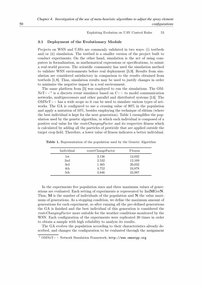
Exploiting Evolution on UAV Control Rules 53
3.1 Deployment of the Evolutionary Module
Projects on WSN and UAVs are commonly validated in two ways: (i) testbedsand/or (ii) simulation. The testbed is a smaller version of the project built toconduct experiments. On the other hand, simulation is the act of using com-puters in formalization, as mathematical expressions or specifications, to mimica real-world process. The scientific community has used the simulation methodto validate WSN environments before real deployment [3,9]. Results from sim-ulation are considered satisfactory in comparison to the results obtained fromtestbeds [1,8]. Thus, simulation results may be used to justify changes in orderto minimize the negative impact in a real environment.
The same platform from [5] was employed to run the simulations. The OM-NeT++1 is a discrete event simulator based on C++ to model communicationnetworks, multiprocessors and other parallel and distributed systems [14]. TheOMNeT++ has a wide scope so it can be used to simulate various types of net-works. The GA is configured to use a crossing value of 90% in the populationand apply a mutation of 10%, besides employing the technique of elitism (wherethe best individual is kept for the next generation). Table 1 exemplifies the pop-ulation used by the genetic algorithm, in which each individual is composed of apositive real value for the routeChangingFactor and its respective fitness whichis calculated by adding all the particles of pesticide that are applied outside thetarget crop field. Therefore, a lower value of fitness indicates a better individual.
Table 1. Representation of the population used by the Genetic Algorithm
Individual routeChangeFactor Fitness
1st 2.136 12,0322nd 2.532 12,1693rd 1.465 20,0324th 4.752 24,8785th 3.846 22,987
In the experiments five population sizes and three maximum values of gener-ations are evaluated. Each setting of experiments is represented by IndMGerN.Thus, M is the number of individuals of the population and N the value maxi-mum of generations. As a stopping condition, we define the maximum amount ofgenerations for each experiment, so after running all the pre-defined generationsthe GA is finished and the best individual of this generation is considered therouteChangingFactor more suitable for the weather conditions monitored by theWSN. Each configuration of the experiments were replicated 30 times in orderto obtain a sample with high reliability to analyze its results.
The GA evolves the population according to their characteristics already de-scribed, and changes the configuration to be evaluated through the assignment
1 OMNeT++ Network Simulation Framework, http://www.omnetpp.org
50Chapter 4. Investigation of the use of meta-heuristic algorithms to adjust the spray element
configurations
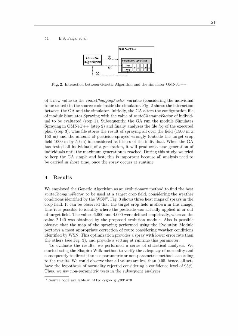
54 B.S. Faiçal et al.
Fig. 2. Interaction between Genetic Algorithm and the simulator OMNeT++
of a new value to the routeChangingFactor variable (considering the individualto be tested) in the source code inside the simulator. Fig. 2 shows the interactionbetween the GA and the simulator. Initially, the GA alters the configuration fileof module Simulates Spraying with the value of routeChangingFactor of individ-ual to be evaluated (step 1). Subsequently, the GA run the module SimulatesSpraying in OMNeT++ (step 2) and finally analyzes the file log of the executedplan (step 3). This file stores the result of spraying all over the field (1500 m x150 m) and the amount of pesticide sprayed wrongly (outside the target cropfield 1000 m by 50 m) is considered as fitness of the individual. When the GAhas tested all individuals of a generation, it will produce a new generation ofindividuals until the maximum generation is reached. During this study, we triedto keep the GA simple and fast; this is important because all analysis need tobe carried in short time, once the spray occurs at runtime.
4 Results
We employed the Genetic Algorithm as an evolutionary method to find the bestrouteChangingFactor to be used at a target crop field, considering the weatherconditions identified by the WSN2. Fig. 3 shows three heat maps of sprays in thecrop field. It can be observed that the target crop field is shown in this image,thus it is possible to identify where the pesticide was actually applied in or outof target field. The values 6.000 and 4.000 were defined empirically, whereas thevalue 2.140 was obtained by the proposed evolution module. Also is possibleobserve that the map of the spraying performed using the Evolution Moduleportrays a most appropriate correction of route considering weather conditionsidentified by WSN. This optimization provides a spray with lower error rate thanthe others (see Fig. 3), and provide a setting at runtime this parameter.
To evaluate the results, we performed a series of statistical analyzes. Westarted using the Shapiro Wilk method to verify the adequacy of normality andconsequently to direct it to use parametric or non-parametric methods accordingto the results. We could observe that all values are less than 0.05, hence, all setshave the hypothesis of normality rejected considering a confidence level of 95%.Thus, we use non-parametric tests in the subsequent analyzes.
2 Source code available in http://goo.gl/9S14T0
51

Exploiting Evolution on UAV Control Rules 55
(a) routeChangingFactor = 6.000
(b) routeChangingFactor = 4.000
(c) routeChangingFactor = 2.140
Fig. 3. A heat map to represent the chemicals sprayed on the crop at the end of thesimulation. The green colour represents no pesticide and red represents the most con-centrated places. The thin black lines show the crop field that needs to have chemicalssprayed. (a) and (b) Evaluations with empirical values. (c) Evaluation with routeChang-
ingFactor obtained by the genetic algorithm. We can see that when employing therouteChangingFactor obtained by the genetic algorithm we have the best adjusts inthe UAV track, attempting to keep the chemicals within the boundary lane. It is worthto highlight that, as the simulation starts with wind, the UAV always starts the dis-persion of the chemicals outside the boundary.
As implied in Fig 4(a), there appears to be an improvement in the obtainedresults (lower error) with the increase of individuals. The pairwise comparisonsusing Wilcoxon rank sum test shows that there is a significant difference inpopulations formed by 3, 5 and 10 Individuals but not for populations with 10,15 and 20 Individuals. This may imply that there is need to further increase thenumber of generations. Figures 5(a) and 6(a) shows the results with 50 and 100generations.
The pairwise comparisons using Wilcoxon rank sum test shows that for ex-periments using populations with 5, 10, 15 and 20 Individuals for 50 generationsthere is no significant difference. However, using populations with 5 and 10 in-dividuals have lower accuracy populations when compared with the results ofthe populations with 15 and 20 Individuals. To the experiments with 5, 10, 15and 20 Individuals and 100 generations no significant difference and their ac-curacies are similar. It should be noted that the settings used in the GeneticAlgorithm provide results with high accuracies. Therefore, the settings that re-sulted in the best results are the populations formed with 15 and 20 Individualsto 50 Generations and 5, 10, 15 and 20 Individuals to 100 Generations.
From Fig. 4(b), 5(b) and 6(b), we can see that the average runtime time growsas the population and the amount of generations increase. Considering the set-tings that correspond to the best results (Ind15Ger50, Ind20Ger50, Ind5Ger100,Ind10Ger100, Ind15Ger100, Ind20Ger100), it is possible to note that the set-ting Ind5Ger100 has the lowest average runtime of 44.12 seconds. As described
52Chapter 4. Investigation of the use of meta-heuristic algorithms to adjust the spray element
configurations
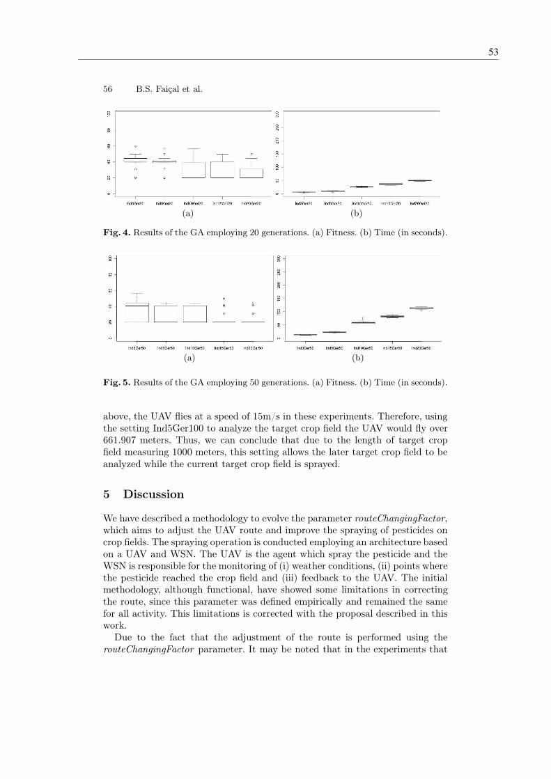
56 B.S. Faiçal et al.
(a) (b)
Fig. 4. Results of the GA employing 20 generations. (a) Fitness. (b) Time (in seconds).
(a) (b)
Fig. 5. Results of the GA employing 50 generations. (a) Fitness. (b) Time (in seconds).
above, the UAV flies at a speed of 15m/s in these experiments. Therefore, usingthe setting Ind5Ger100 to analyze the target crop field the UAV would fly over661.907 meters. Thus, we can conclude that due to the length of target cropfield measuring 1000 meters, this setting allows the later target crop field to beanalyzed while the current target crop field is sprayed.
5 Discussion
We have described a methodology to evolve the parameter routeChangingFactor,which aims to adjust the UAV route and improve the spraying of pesticides oncrop fields. The spraying operation is conducted employing an architecture basedon a UAV and WSN. The UAV is the agent which spray the pesticide and theWSN is responsible for the monitoring of (i) weather conditions, (ii) points wherethe pesticide reached the crop field and (iii) feedback to the UAV. The initialmethodology, although functional, have showed some limitations in correctingthe route, since this parameter was defined empirically and remained the samefor all activity. This limitations is corrected with the proposal described in thiswork.
Due to the fact that the adjustment of the route is performed using therouteChangingFactor parameter. It may be noted that in the experiments that
53

Exploiting Evolution on UAV Control Rules 57
(a) (b)
Fig. 6. Results of the GA employing 100 generations. (a) Fitness. (b) Time (in seconds).
we use 20 generations to find the best parameter, settings involving populationswith 10, 15 and 20 individuals are not significantly different. However, only 50%of the results achieved is the best possible value. The same happens with theresults obtained in experiments using populations with 5 and 10 individualswhen evolved by 50 generations. Moreover, the results obtained using 15 and20 individuals by 50 generations and also 5, 10, 15 and 20 individuals by 100generations achieved the best possible value and showed greater stability in itsresults. Considering these results, the configuration Ind5Ger100, correspondingto a population of 5 individuals with 100 generations, has satisfactory behaviorfor the purpose this study. This configuration is able to achieve good results withhigh accuracy at relatively low average runtime. Other settings of the experi-ments not cited in this section are considered unsuitable for solving this problembecause of its low accuracy.
It is worth mentioning that the error in no case is less than 20% because themethodology considers that the UAV starts spraying at a fixed point and theroute adjustment occurs after some predefined time. Thus, this error occurs atthe beginning of the crop field where spraying has the influence of the weatherconditions. Therefore, a better understanding of the results is made from thefollowing reading: starting spraying in position X, the best routeChangingFactorhas value Y, which will result in an error of Z% in weather conditions informedby the WSN.
Lastly, it is important to remember that the developed methodology, whichevolve the routeChangingFactor, had as main motivation the possibility of pro-viding to UAV with a intelligent behavior, adjusting its route considering weatherconditions. Thus, this becomes a dynamic policy for a naturally dynamic environ-ment. The next stages of this project will be as follows: (i) developing the systemusing real hardware, addressing the reality gap in communications between theUAV and the WSN, the behaviour of the UAV and the sensor capabilities and(ii) investigating the use of other evolutionary techniques, like NSGA-II [4] andDifferential Evolution [11]. As a final observation, since it is necessary to improvethe simulation environment (which allows quicker and safer evaluations) otherfuture work should seek to improve the current chemical dispersion module andthe physical behaviour of the UAV.
54Chapter 4. Investigation of the use of meta-heuristic algorithms to adjust the spray element
configurations
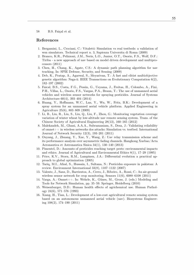
58 B.S. Faiçal et al.
References
1. Bergamini, L., Crociani, C.: Vitaletti: Simulation vs real testbeds: a validation ofwsn simulators. Technical report n. 3, Sapienza Universita di Roma (2009)
2. Branco, K.R., Pelizzoni, J.M., Neris, L.O., Junior, O.T., Osorio, F.S., Wolf, D.F.:Tiriba - a new approach of uav based on model driven development and multipro-cessors (2011)
3. Chen, H., Chang, K., Agate, C.S.: A dynamic path planning algorithm for uavtracking. In: SPIE Defense, Security, and Sensing (2009)
4. Deb, K., Pratap, A., Agarwal, S., Meyarivan, T.: A fast and elitist multiobjectivegenetic algorithm: Nsga-ii. IEEE Transactions on Evolutionary Computation 6(2),182–197 (2002)
5. Faical, B.S., Costa, F.G., Pessin, G., Ueyama, J., Freitas, H., Colombo, A., Fini,P.H., Villas, L., Osorio, F.S., Vargas, P.A., Braun, T.: The use of unmanned aerialvehicles and wireless sensor networks for spraying pesticides. Journal of SystemsArchitecture 60(4), 393–404 (2014)
6. Huang, Y., Hoffmann, W.C., Lan, Y., Wu, W., Fritz, B.K.: Development of aspray system for an unmanned aerial vehicle platform. Applied Engineering inAgriculture 25(6), 803–809 (2009)
7. Li, B., Liu, R., Liu, S., Liu, Q., Liu, F., Zhou, G.: Monitoring vegetation coveragevariation of winter wheat by low-altitude uav remote sensing system. Trans. of theChinese Society of Agricultural Engineering 28(13), 160–165 (2012)
8. Malekzadeh, M., Ghani, A.A.A., Subramaniam, S., Desa, J.: Validating reliabilityof omnet++ in wireless networks dos attacks: Simulation vs. testbed. InternationalJournal of Network Security 12(3), 193–201 (2011)
9. Ouyang, J., Zhuang, Y., Xue, Y., Wang, Z.: Uav relay transmission scheme andits performance analysis over asymmetric fading channels. Hangkong Xuebao/ActaAeronautica et Astronautica Sinica 34(1), 130–140 (2013)
10. Pimentel, D.: Amounts of pesticides reaching target pests: environmental impactsand ethics. Journal of Agricultural and Environmental Ethics 8(1), 17–29 (1995)
11. Price, K.V., Storn, R.M., Lampinen, J.A.: Differential evolution a practical ap-proach to global optimization (2005)
12. Tariq, M.I., Afzal, S., Hussain, I., Sultana, N.: Pesticides exposure in pakistan: Areview. Environment International 33(8), 1107–1122 (2007)
13. Valente, J., Sanz, D., Barrientos, A., Cerro, J., Ribeiro, A., Rossi, C.: An air-groundwireless sensor network for crop monitoring. Sensors 11(6), 6088–6108 (2011)
14. Varga, A.: Omnet++. In: Wehrle, K., Günes, M., Gross, J. (eds.) Modeling andTools for Network Simulation, pp. 35–59. Springer, Heidelberg (2010)
15. Weisenburger, D.D.: Human health effects of agrichemical use. Human Pathol-ogy 24(6), 571–576 (1993)
16. Xiang, H., Tian, L.: Development of a low-cost agricultural remote sensing systembased on an autonomous unmanned aerial vehicle (uav). Biosystems Engineer-ing 108(2), 174–190 (2011)
55


57
CHAPTER
5
EVALUATION OF THE EFFECTIVENESS OF
ADAPTING TO THE BEHAVIOR OF THE
SPRAY ELEMENT

Fine-tuning of UAV control rules for sprayingpesticides on crop fields
Bruno S. Faiçal∗, Gustavo Pessin†, Geraldo P. R. Filho∗,
André C. P. L. F. Carvalho∗, Gustavo Furquim∗ and Jó Ueyama∗
∗Institute of Mathematics and Computer Science (ICMC)
University of São Paulo (USP) – São Carlos, SP, Brazil
Email: {bsfaical, geralop, andre, furquim, joueyama}@icmc.usp.br†Vale Institute of Technology, Belém, PA, Brazil
Email: [email protected]
Abstract—The use of pesticides in agriculture is essential tomaintain the quality of large-scale production. The sprayingof these products by using aircraft speeds up the processand prevents compacting of the soil. However, adverse weatherconditions (e.g. the speed and direction of the wind) can impairthe effectiveness of the spraying of pesticides in a target crop field.Thus, there is a risk that the pesticide can drift to neighboringcrop fields. It is believed that a large amount of all the pesticideused in the world drifts outside of the target crop field and onlya small amount is effective in controlling pests. However, withincreased precision in the spraying, it is possible to reduce theamount of pesticide used and improve the quality of agriculturalproducts as well as mitigate the risk of environmental damage.With this objective, this paper proposes a methodology basedon Particle Swarm Optimization (PSO) for the fine-tuning ofcontrol rules during the spraying of pesticides in crop fields.This methodology can be employed with speed and efficiency andachieve good results by taking account of the weather conditionsreported by a Wireless Sensor Network (WSN). In this scenario,the UAV becomes a mobile node of the WSN that is able tomake personalized decisions for each crop field. The experimentsthat were carried out show that the optimization methodologyproposed is able to reduce the drift of pesticides by fine-tuningof control rules.
I. INTRODUCTION
Pesticides, also known as agrochemicals, are generallyapplied in agricultural crop fields to increase productivity, im-prove quality and reduce production costs. However, prolongedcontact (either directly or indirectly) with these products cancause various diseases to humans such as several types ofcancers, complications in the respiratory system and neuro-logical diseases [1]. It is estimated that about 2.5 milliontons of pesticides are used each year throughout the worldand this amount is growing [2]. Much of the pesticides arewasted during the spraying process due to the type of employedtechnologies. There are evidences that show that the drift ofpesticides is generally found at a distance of 48 m and 800 mfrom the target crop field, the deviation can reach a distanceof 5 km to 32 km, downwind [3].
The use of UAVs to carry out the task of spraying pesticidescan be beneficial to many reasons, including (i) to reducehuman contact with the chemicals, which helps to preserve hu-man health; and (ii) to improve the performance of the sprayingoperation, avoiding the presence of chemicals outside designedareas, which helps to preserve neighborhood fields, that can
be other crops, preserved nature areas or water sources. Setsof control rules, to be employed in an autonomous UAV,are very hard to develop and harder to fine-tune to eachenvironment characteristics. Thus, a fine-tuning phase mustinvolves the parameters of the algorithm, due to the mechanicalcharacteristics of each UAV and also must take into accountthe type of crop being handled and the type of pesticide tobe used. In this paper we present a evolutionary algorithm tofine-tune sets of control rules, to be employed in an simulatedautonomous UAV. We describe the proposed architecture andinvestigations about changing in the evolutionary parameters.
The proposed architecture employs an UAV, which has asystem of coupled spray, and it is able to communicate with theWireless Sensor Network, which is organized in a matrix-likedisposition on the crop field. This WSN aims to send feedbackon the weather conditions and how spraying actually are fallingin the target crop field. Based on the information received, theUAV appropriately applies a policy to correct its route. Hence,the main contributions of this research are as follows: (i)investigate an evolutionary methodology capable of minimizehuman contact with pesticides, (ii) evaluate an evolutionaryapproach able to minimize the error in spraying pesticidesin areas of growing vegetables and fruits, (iii) investigatetechniques able to maximize quality in agricultural production,and (iv) contribute to increase the autonomy of the architectureproposed by [4], in which the policy parameters were setempirically and applied independent of weather conditions.
This paper is divided into six sections. Section II presentsother studies related to this paper. Following this, Section IIIpresents an outline of the architecture to clarify the scope ofthis paper and the optimization methodology proposed in thiswork. The experiments and results are presented and discussedin Section IV, and then compared with the results found inthe literature. Finally, Section V summarizes the conclusionsobtained from the results and suggests how this paper mightencourage further studies in this field.
II. RELATED WORK
There are several studies that suggest how UAVs or WSNscan be employed for monitoring agricultural production, occa-sionally by integrating both technologies [5], [6], [7]. However,this work differs in so far as it proposes a PSO to optimizethe control rules of the UAV at runtime, based in feedback
2014 IEEE 26th International Conference on Tools with Artificial Intelligence
1082-3409/14 $31.00 © 2014 IEEE
DOI
528
2014 IEEE 26th International Conference on Tools with Artificial Intelligence
1082-3409/14 $31.00 © 2014 IEEE
DOI
528
2014 IEEE 26th International Conference on Tools with Artificial Intelligence
1082-3409/14 $31.00 © 2014 IEEE
DOI 10.1109/ICTAI.2014.85
528
2014 IEEE 26th International Conference on Tools with Artificial Intelligence
1082-3409/14 $31.00 © 2014 IEEE
DOI 10.1109/ICTAI.2014.85
528
2014 IEEE 26th International Conference on Tools with Artificial Intelligence
1082-3409/14 $31.00 © 2014 IEEE
DOI 10.1109/ICTAI.2014.85
528
2014 IEEE 26th International Conference on Tools with Artificial Intelligence
1082-3409/14 $31.00 © 2014 IEEE
DOI 10.1109/ICTAI.2014.85
528
2014 IEEE 26th International Conference on Tools with Artificial Intelligence
1082-3409/14 $31.00 © 2014 IEEE
DOI 10.1109/ICTAI.2014.85
528
2014 IEEE 26th International Conference on Tools with Artificial Intelligence
1082-3409/14 $31.00 © 2014 IEEE
DOI 10.1109/ICTAI.2014.85
528
2014 IEEE 26th International Conference on Tools with Artificial Intelligence
1082-3409/14 $31.00 © 2014 IEEE
DOI 10.1109/ICTAI.2014.85
527
58 Chapter 5. Evaluation of the effectiveness of adapting to the behavior of the spray element

provided by WSN about weather conditions in the agriculturalfield.
Valente and collaborators [8] show a WSN-based systemand UAV to monitor the of vineyards. The WSNs collectinformation about weather, soil and planting conditions andthen makes it available to farmers. However, a field crop maybe hundreds of meters away from other fields and sometimesthere are barriers (e.g., rivers and roads) that separate two cropfields. Thus, it may not be viable or cost-effective to use cablesto connect the WSN. Although the use of powerful wirelessdevices allows communication between WSNs, this solutioncauses higher energy consumption and involves reducing thelifetime of the WSNs. One solution that can be adopted toovercome these limitations is to employ a UAV to fly overthe crop fields and gather information from each WSN, whichit can then convey to a processing center. Although thisstudy demonstrates that UAVs and WSNs can be integrated toprovide efficient solutions or improvements in an agriculturalsetting, no methodology is employed for optimization at run-time. Additionally, a UAV is used as a mobile node in a WSNwithout any chance of having an effect on the environment.
In [9] a specific system is proposed to spray pesticide.This system should be coupled with a UAV that is capableof carrying approximately 22.7 kg. The model used in thiswork is UAV SR200 manufactured by Rotomotion. The spraysystem consists of four main components: (i) a metal tube withnozzles; (ii) a tank to store pesticide; (iii) a pump to movethe liquid; and (iv) a mechanism for controlling the activationof the spray. The spraying system can carry up to 5 kg ofpesticide, which is enough to spray 14 ha; and it has a flighttime of around 90 minutes. The main objective of this study isto validate the proposed system and evaluate different types ofspray nozzles. However, the weather conditions were not takeninto account. Additionally, it does not include a discussion ofan evolutionary methodology that is able to optimize controlof this activity.
Faiçal and collaborators [4] proposed an architectureformed of UAV and WSN to spray pesticide in crop fields.It is known that adverse weather conditions, such as windsof high speed, can cause errors in the spraying process. Thestudy shows how the recommended architecture can reduce therisk of errors and increase control over this activity. With theaid of feedback from the WSN about pesticide concentrations,the route is gradually changed until the sensor node canidentify a correct application of the product. However, theparameters set for the route change are apply in differentweather conditions, which may impair the performance of thisarchitecture. As mentioned earlier, this paper addresses thislimitation by evaluating a methodology that is employed forthe fine-tuning of a parameter that ponders the intensity whichthe route followed by the UAV is changed.
III. METHODS
A. UAV and WSN architecture for spraying on crop fields
Fig. 1 illustrates how the UAV acts as an agent in thecrop fields. The UAV flies over the area, equipped with aspray system and a communication module, which enablesdata exchange (through a communication link) with distributedWSN in the crop fields, and sprays the pesticide in its entire
Fig. 1. Example of spraying in crop fields with the architecture proposed by[4]. This architecture consists of a UAV (to spray) and WSN (to monitor). Ifthe WSN identifies an unbalanced spray on its sensor nodes, the UAV changesits route to correct the spraying of the pesticide.
length [4]. The WSN is represented solely within the targetcrop fields and is bounded by two dark dashed lines (fromtop left to bottom right) to simplify the viewing image. Atthe top of Fig. 1, there are two arrows that indicate the winddirection at a specific location. Through its communicationlink with the WSN, the UAV is able to obtain informationabout the weather (e.g. speed and direction of the wind)and the concentration of the pesticides sprayed on the crops.If an imbalance is detected in this concentration (e.g. thesensor on the left identifies a higher concentration than thesensor on the right), possibly caused by the wind, the UAVadopts a policy that involves changing its route to balancethe application of pesticides in the whole extent of the targetcrop fields. This policy also helps to prevent overlapping whenthe chemical is applied. In Fig. 1, the correction of the routeis represented by small arrows between the images of theUAV. The parameter called routeChangingFactor is employedin the route change function to set the degree of intensity(e.g. mild or sharp) so that the change can be made. However,although this parameter is important to ensure the success ofthe spraying, its value is set empirically before the beginningof the flight and is used in all weather conditions that occurduring the spraying. This characteristic can affect the qualityof the spraying; for example, a sharp correction might be madein an environment where a low wind speed has been identified.Moreover, an increase of complexity in this environment mightcause variable behavior. In other words, the weather conditionscan change during the activity, and this is detrimental to allthe architecture if it has static configuration.
To overcome the problems mentioned above, this paperproposes a methodology based on Particle Swarm Optimizationto optimize the parameter of the routeChangingFactor inruntime. As previously mentioned, the parameter of routechange has a large influence on spraying and, in addition,the architecture is employed in a dynamic environment. Thus,it is worth investigating a methodology that is able to finda value for the parameter of the routeChangingFactor (andis close to an optimal solution) and which can be used andupdated during the spraying. Fig. 2 shows the behavior ofthe architecture when the optimization methodology is used.It assumes that a crop field is composed of several smallimaginary subareas in a rectangular shape. Thus, if all thesubareas are sprayed, this results in a full spraying of thecrop field. Each subarea will be called a “crop field” during
529529529529529529529529528
59

Fig. 2. Behavior of the architecture that employs the proposed optimizationmethodology. The Control Station (A) is installed outside the target crop field,in a zone that remains communicable with the UAV (B). During the sprayingof the current crop field (D), the UAV sends a request for weather informationabout the next crop field (E) to the WSN (C). When the information requestedis received, the UAV sends it to Control Station (A) where it will be used by theoptimization methodology. At the end of the optimization, the Control Stationsends the new configuration to UAV. The settings will be updated when thespraying of the current crop field has been completed and the spraying of thenext crop field has begun.
this study. The flight plan of the UAV is defined to spraythe next crop field, soon after work on the current crop fieldhas been completed. The route change, as described earlier,is made in the current crop field (D). In parallel to thisactivity, the UAV (B) queries the WSN (C) about the weatherconditions in the next crop field (E). In this stage the requestcan reach the nodes that are deployed inside the next cropfield by using multihop (not shown in the diagram). Only theendpoints of the communication (source and destination) areshown for a clear image. As soon as the UAV obtains weatherinformation, this is sent to Control Station (A) to optimizethe parameter of the routeChangingFactor. At this time, theoptimization methodology proposal is run together with theweather information. At the end of the optimization, the bestvalue of the parameter that is found is sent to the UAV. Whenthe spraying of the current crop field (D) has been finalized,the UAV updates its settings so that the spraying of the nextcrop field (E) can start. It should be highlighted that the useof a Control Station provides more powerful computation and,in addition, allows a pilot (on the ground) to oversee the flightand, if necessary, intervene in the control of the UAV.
B. Optimization of control rules
The optimization methodology proposed this paper isessentially composed of an algorithm based on PSO [10],[11]. This algorithm searches for a non-optimal value forthe routeChangingFactor parameter and in one computationmodel of environment evaluates the accuracy of spraying byapplying the weather information received from the WSN.Lastly, the algorithm returns the best solution (value perparameter) and this is assessed so that it can be applied inthe next crop field. One important condition of this algorithmis that the computational cost (runtime) should be lower thanthe time required for spraying one crop field (subarea). Hence,
the search space is delimited in one zone that has valuesof different acuteness (e.g. abrupt, smooth and moderate).Additionally, this delimiting of the search space allows a morerapid convergence. Following the definition of search space:
routeChangingFactor = {x ∈ R | 1.0 ≤ R ≤ 10.0}
The optimization process is conducted in two ways at thesame time: (i) through cooperation (group learning) and (ii)competition (single learning), by considering the particles ofa swarm. Each particle is initialized in a random position(possible solution) within a search space. In each iteration ofthe algorithm, the velocity and position of the particles areupdated. The position found by the swarm with best fitnessand the positions with best fitness found by each particleindividually are considered for updating. As the positions ofthe particles are possible values for the routeChangingFactorparameter contained in search space, the velocity of the particleindicates how far and in what direction this value will move (toa new position). The new position of each particle is obtainedby Equation 1 (where: Xid is the position and Vid is thevelocity of particle i in a moment d), while the velocity isupdated in each iteration with Equation 2 (where: wi is theinertia, C1 and C2 establish the importance of social trend orindividual (cooperation or competition), Pid is the best positionfound by individual particle, Pgd is the best position found byswarm and, finally, rand() and Rand() are different randomvalues for a good exploration of search space) [12].
Xid+1 = Xid + Vid (1)
Vid =wi ∗ Vid + C1 ∗ rand() ∗ (Pid −Xid)
+C2 ∗Rand() ∗ (Pgd −Xid)(2)
Algorithm 1 shows details of the optimization process. Theparticles are initialized in random positions inside the searchspace. The stop condition is defined by the amount of iterationthat the algorithm has to run. This stop condition allowsthe average runtime to be analyzed in worst case scenarios,when all the iterations are run to find one possible solution.Following this, one stop condition can be added with the aim offinalizing the algorithm when identifying the convergence thathas occurred. It should be noted that the runtime in worst casesshould be lower than the time required for spraying a crop field(subarea). In each iteration, all the particles will have theirpositions evaluated and if the “fitness” of a particle is the bestfound by the swarm so far, the algorithm stores this position.On the other hand, if the position is not the best in global termsbut is the best of particle the algorithm also stores this positionin the particle. Later on, the velocity and the position of eachparticle are updated. When the algorithm achieves maximuminteraction, it is finalized and the best position found by theswarm is returned.
The objective function (FuncObjetive) contained in the al-gorithm, cited in Line 5 of Algorithm 1, refers to an interactionwith one project inside OMNeT++ software. The project isan implementation of a computational model to evaluate thespraying [4]. This interaction tests and analyzes the quality ofspray in each position of all the particles. The OMNeT++1
1OMNeT++ Network Simulation Framework, http://www.omnetpp.org
530530530530530530530530529
60 Chapter 5. Evaluation of the effectiveness of adapting to the behavior of the spray element
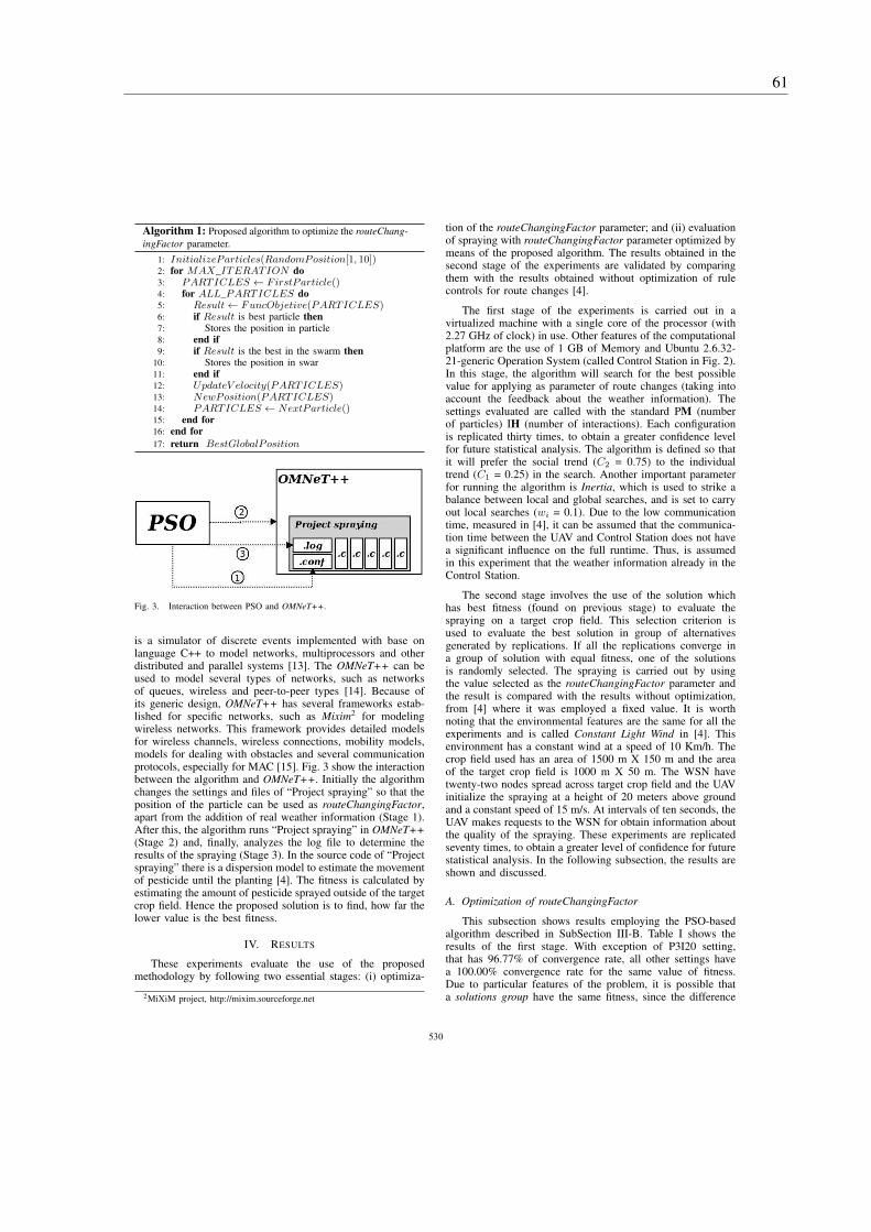
Algorithm 1: Proposed algorithm to optimize the routeChang-
ingFactor parameter.
1: InitializeParticles(RandomPosition[1, 10])2: for MAX_ITERATION do3: PARTICLES ← FirstParticle()4: for ALL_PARTICLES do5: Result ← FuncObjetive(PARTICLES)6: if Result is best particle then7: Stores the position in particle8: end if9: if Result is the best in the swarm then
10: Stores the position in swar11: end if12: UpdateV elocity(PARTICLES)13: NewPosition(PARTICLES)14: PARTICLES ← NextParticle()15: end for16: end for
17: return BestGlobalPosition
Fig. 3. Interaction between PSO and OMNeT++.
is a simulator of discrete events implemented with base onlanguage C++ to model networks, multiprocessors and otherdistributed and parallel systems [13]. The OMNeT++ can beused to model several types of networks, such as networksof queues, wireless and peer-to-peer types [14]. Because ofits generic design, OMNeT++ has several frameworks estab-lished for specific networks, such as Mixim2 for modelingwireless networks. This framework provides detailed modelsfor wireless channels, wireless connections, mobility models,models for dealing with obstacles and several communicationprotocols, especially for MAC [15]. Fig. 3 show the interactionbetween the algorithm and OMNeT++. Initially the algorithmchanges the settings and files of “Project spraying” so that theposition of the particle can be used as routeChangingFactor,apart from the addition of real weather information (Stage 1).After this, the algorithm runs “Project spraying” in OMNeT++(Stage 2) and, finally, analyzes the log file to determine theresults of the spraying (Stage 3). In the source code of “Projectspraying” there is a dispersion model to estimate the movementof pesticide until the planting [4]. The fitness is calculated byestimating the amount of pesticide sprayed outside of the targetcrop field. Hence the proposed solution is to find, how far thelower value is the best fitness.
IV. RESULTS
These experiments evaluate the use of the proposedmethodology by following two essential stages: (i) optimiza-
2MiXiM project, http://mixim.sourceforge.net
tion of the routeChangingFactor parameter; and (ii) evaluationof spraying with routeChangingFactor parameter optimized bymeans of the proposed algorithm. The results obtained in thesecond stage of the experiments are validated by comparingthem with the results obtained without optimization of rulecontrols for route changes [4].
The first stage of the experiments is carried out in avirtualized machine with a single core of the processor (with2.27 GHz of clock) in use. Other features of the computationalplatform are the use of 1 GB of Memory and Ubuntu 2.6.32-21-generic Operation System (called Control Station in Fig. 2).In this stage, the algorithm will search for the best possiblevalue for applying as parameter of route changes (taking intoaccount the feedback about the weather information). Thesettings evaluated are called with the standard PM (numberof particles) IH (number of interactions). Each configurationis replicated thirty times, to obtain a greater confidence levelfor future statistical analysis. The algorithm is defined so thatit will prefer the social trend (C2 = 0.75) to the individualtrend (C1 = 0.25) in the search. Another important parameterfor running the algorithm is Inertia, which is used to strike abalance between local and global searches, and is set to carryout local searches (wi = 0.1). Due to the low communicationtime, measured in [4], it can be assumed that the communica-tion time between the UAV and Control Station does not havea significant influence on the full runtime. Thus, is assumedin this experiment that the weather information already in theControl Station.
The second stage involves the use of the solution whichhas best fitness (found on previous stage) to evaluate thespraying on a target crop field. This selection criterion isused to evaluate the best solution in group of alternativesgenerated by replications. If all the replications converge ina group of solution with equal fitness, one of the solutionsis randomly selected. The spraying is carried out by usingthe value selected as the routeChangingFactor parameter andthe result is compared with the results without optimization,from [4] where it was employed a fixed value. It is worthnoting that the environmental features are the same for all theexperiments and is called Constant Light Wind in [4]. Thisenvironment has a constant wind at a speed of 10 Km/h. Thecrop field used has an area of 1500 m X 150 m and the areaof the target crop field is 1000 m X 50 m. The WSN havetwenty-two nodes spread across target crop field and the UAVinitialize the spraying at a height of 20 meters above groundand a constant speed of 15 m/s. At intervals of ten seconds, theUAV makes requests to the WSN for obtain information aboutthe quality of the spraying. These experiments are replicatedseventy times, to obtain a greater level of confidence for futurestatistical analysis. In the following subsection, the results areshown and discussed.
A. Optimization of routeChangingFactor
This subsection shows results employing the PSO-basedalgorithm described in SubSection III-B. Table I shows theresults of the first stage. With exception of P3I20 setting,that has 96.77% of convergence rate, all other settings havea 100.00% convergence rate for the same value of fitness.Due to particular features of the problem, it is possible thata solutions group have the same fitness, since the difference
531531531531531531531531530
61

TABLE I. RESULTS OF THE OPTIMIZATION OF THE
routeChangingFactor PARAMETER. P-VALUE LESS THAN 0.05 INDICATES A
NON-NORMAL ADEQUACY, THEM, IT LEADS TO NON-PARAMETRIC
STATISTICAL ANALYSIS.
Settings Convergence Average time Shapiro Wilkrate (%) of evolutions (s) p-value
P3I20 96.77 18.617 ± 0.371 0.330P3I50 100.00 45.927 ± 0.649 0.012P3I100 100.00 93.854 ± 1.555 0.076P5I20 100.00 30.705 ± 0.506 0.150P5I50 100.00 77.162 ± 0.766 0.362P5I100 100.00 158.995 ± 3.143 0.302P10I20 100.00 62.549 ± 0.912 0.023P10I50 100.00 157.957 ± 2.976 0.212P10I100 100.00 313.335 ± 1.488 0.047P15I20 100.00 93.606 ± 0.799 0.009P15I50 100.00 235.189 ± 1.816 0.101P15I100 100.00 480.359 ± 14.762 0.012P20I20 100.00 125.088 ± 1.059 0.014P20I50 100.00 312.894 ± 2.058 0.165P20I100 100.00 628.324 ± 2.251 0.073
between the values of the routeChangingFactor parameter maybe low enough to have no significant influence on the sprayingin specific situations.
For validate the results, was carried out several staticanalysis. We started using Shapiro Wilk method to verifythe adequacy of normality and consequently to lead it to useparametric or non-parametric methods according to the results.Only 53.33% of solution groups have value higher than 0.05(see Table I), therefore the hypothesis of normality is rejectedconsidering a confidence level of 95%. Thus we use non-parametric tests in the subsequent analyzes.
The pairwise comparisons performed with Wilcoxon RankSum Test show3 that there is no significant difference betweenthe solution groups. Additionally, the Friedman Rank Sum Testshows a p-value of 0.449, which also indicates that there isno significant difference between the solution groups. Bothmethods have a confidence level of 95%. Despite these results,the P3I20 setting has a lower convergence rate than the othersettings. This difference in convergence rate is not indicatedby the methods, because the non-converged solution represents3.5% of all the solutions (i.e. a value less than the confidencelevel). Other important point contained in Table I, is theaverage time ± standard deviation (in seconds) for each settingof the algorithm. The spraying of a target crop field is carriedout in ≈ 66.667 seconds (in accordance with the speed ofthe UAV) and as mentioned previously the runtime must beless than the time required for spraying a target crop field.Hence, the settings indicated for this application are P5I20,P10I20 and P3I50. These settings allow the optimization ofthe routeChangingFactor parameter with an appropriate timeand a convergence rate of 100%.
In conducting an analysis of the position of the solutionsin search space and visualizing the non-convergent solution,we have plotted all the solutions on the basis of their valuein search space (see Fig. 4). It can be seen that the proposedalgorithm is capable of finding a region in search space wherevalues are appropriate for the routeChangingFactor parameterin specific climatic conditions. This region in search space isclosely connected with features of the environment and tends
3The results of the Table are not included in this paper due to its size;however, it can be viewed in http://goo.gl/iYR93k.
Fig. 4. Representation of the solutions found by the algorithm in the searchspace.
TABLE II. CORRECT SPRAYING (%) IN THE TARGET CROP FIELD.
Settings Area with correct coverage (%)
CL10 72.871 ± 4.659
CL30 62.113 ± 3.591
CLNO 55.697 ± 0.657
P3I50 86.220 ± 2.538
P5I20 85.811 ± 2.894
P10I20 85.777 ± 2.520
not to be an appropriate region for the next crop field, since itis a dynamic environment. Thus, the algorithm should be runbefore starting the spraying in each crop field to reduce therisk of making a wrong decision. The non-converged solutionoriginating from the P3I20 setting, is marked as “A” in Fig.4. Despite its proximity, this solution does not belong tothe region of appropriate solutions for the weather conditionsreported by the WSN.
After analyzing the optimization of the routeChanging-Factor parameter, we conducted experiments with the aimof evaluating the precision of the spraying by using solutionindicated by the algorithm.
B. Spraying on crop fields
This subsection shows the results of the second stage of theexperiments. This involved analyzing and discussing the resultsof spraying in a crop field by using the solutions found by thePSO. In this stage, the experiments were conducted to supportthe assessment of the proposal, which entailed optimizingthe routeChangingFactor parameter and ran parallel with thespraying of a crop field (in the first stage ) and applied theresults of the optimization to subsequent crop fields (the secondstage). The results of spraying where optimization methodwere used, are compared with the results when there was nooptimization [4].
Settings that did not involve the optimization of the pa-rameter are described as follows: CL10, interval of ten secondsbetween each of the requests of weather information from UAVto WSN; CL30, interval of thirty seconds between each of therequests of weather information from UAV to WSN; CLNOdoes not change its route. These results came from [4].
The settings that use optimization parameter are describedas follows: P5I20, where the algorithm uses five particlesand twenty iterations; P10I20, where the algorithm uses tenparticles and twenty iterations; P3I50, where the algorithmuses three particles and fifty iterations. These results areobtained by the PSO.
532532532532532532532532531
62 Chapter 5. Evaluation of the effectiveness of adapting to the behavior of the spray element

(a) routeChangingFactor = 3.000
(b) routeChangingFactor = 6.000
(c) routeChangingFactor = 7.164
Fig. 6. A heat map to represent the chemicals sprayed on the crop at the end of the simulation. The green colour represents no pesticide and red representsthe most concentrated places. The thin black lines show the crop field that needs to have chemicals sprayed. (a) and (b) Evaluations with empirical values. (c)Evaluation with routeChangingFactor obtained by the PSO. We can see that when employing the routeChangingFactor obtained by the PSO we have the bestadjusts in the UAV track, attempting to keep the chemicals within the boundary lane. It is worth to highlight that, as the simulation starts with wind, the UAValways starts the dispersion of the chemicals outside the boundary.
Fig. 5. Percent of pesticide spraying inside the target crop field. In thisBoxplot, first three results come from [4]; last three results are obtained inthis work by the proposed PSO.
Fig. 5 and Table II show the results of spraying on targetcrop field, comparing results from [4] with results of theproposed PSO. We can note that there is an increase in the areawith correct aplication of pesticides when employd the evolvedrouteChangingFactor. The CL10 is a setting where there is lesserror than between the non-optimized settings. However, allthe optimized settings surpass the precision usually achievedwhen spraying a target crop field. Fig. 6 presents a heat mapto represent the chemicals sprayed on the crop at the end ofthe simulation.
The Shapiro Wilk method, employed to the statisticalanalysis, presents that the hypothesis of normality is rejectedfor one of the sets, when there is a confidence level of 95%.In view of this, we decided to use non-parametric tests in thesubsequent analysis.
TABLE III. RESULTS OF WILCOXON RANK SUM TEST. THERE ARE
EVIDENCES OF DIFFERENCE BETWEEN THE EVOLVED VALUES (P*) AND
THE NON-EVOLVED VALUES (C*) FROM [4] (P-VALUES LESS THAN 0.05).THERE ARE NO EVIDENCES OF DIFFERENCE AMONG EVOLVED VALUES
(P-VALUES GREATER THAN 0.05).
CL10 CL30 CLNO P3I50 P5I20
CL30 0.000
CLNO 0.000 0.000
P3I50 0.000 0.000 0.000
P5I20 0.000 0.000 0.000 0.52
P10I20 0.000 0.000 0.000 0.52 0.79
The pairwise comparisons were performed by means ofthe Wilcoxon Rank Sum Test (see Table III) and show thatthere are significant differences between the results that employthe methodology for optimization and the results when thismethodology is not used. However, no significant differenceswere found when only the settings that use the optimizationmethodology were analyzed. Additionally, the Friedman RankSum Test is also applied to this data and shows a p-valueof 0.000, which suggests that there are significant differencesbetween the results shown in Fig. 5. As a result, it canbe concluded that the use of optimization method for therouteChangingFactor parameter increases the efficiency of thecontrol rules, and reduces the errors when spraying in a cropfield.
V. CONCLUSIONS AND SUGGESTIONS FOR FUTURE WORK
In this paper, we have investigated a methodology basedon Particle Swarm Optimization for fine-tuning the control ruleof the UAV (i.e. the mobile node of WSN). The aim of thisproposal is to provide the optimization of the routeChang-ingFactor parameter and thus reduce the error when sprayingpesticides on crop fields. In our experiments, we evaluatedseveral settings for the optimization method. The results showthat it is possible to obtain 100% of convergence for a groupof values. Thus, the control rule can be adapted to differentweather conditions without human intervention. Additionally,
533533533533533533533533532
63
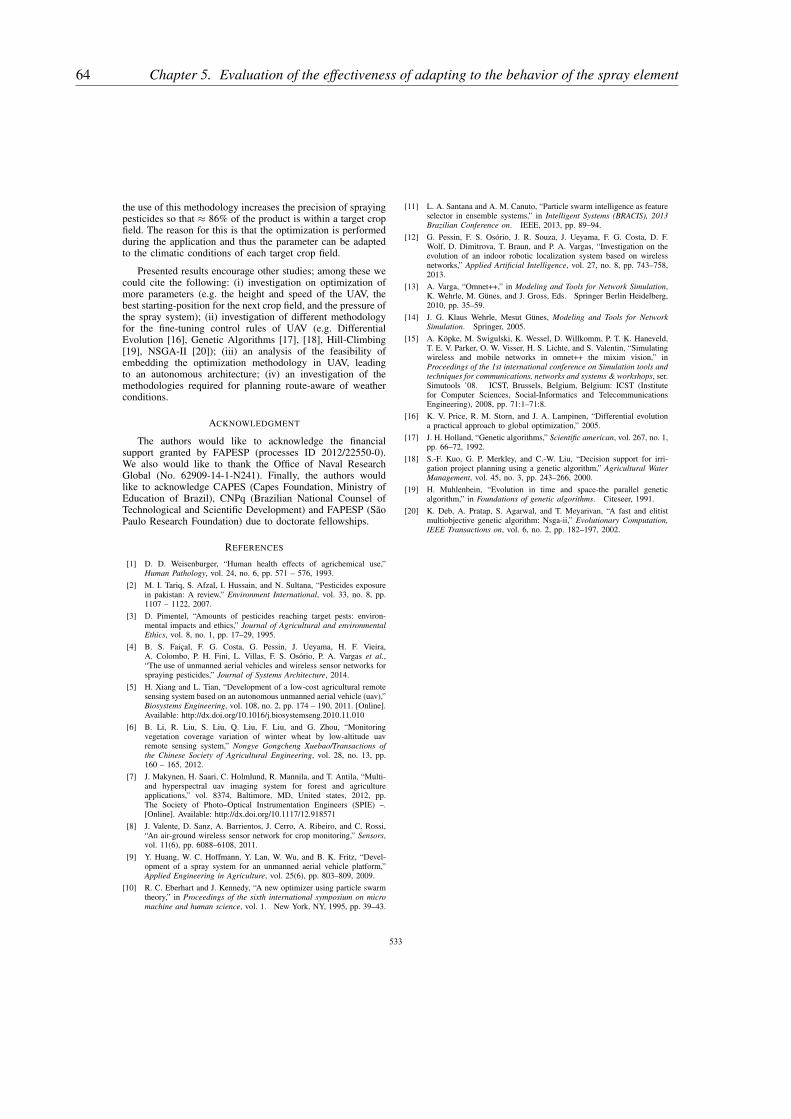
the use of this methodology increases the precision of sprayingpesticides so that ≈ 86% of the product is within a target cropfield. The reason for this is that the optimization is performedduring the application and thus the parameter can be adaptedto the climatic conditions of each target crop field.
Presented results encourage other studies; among these wecould cite the following: (i) investigation on optimization ofmore parameters (e.g. the height and speed of the UAV, thebest starting-position for the next crop field, and the pressure ofthe spray system); (ii) investigation of different methodologyfor the fine-tuning control rules of UAV (e.g. DifferentialEvolution [16], Genetic Algorithms [17], [18], Hill-Climbing[19], NSGA-II [20]); (iii) an analysis of the feasibility ofembedding the optimization methodology in UAV, leadingto an autonomous architecture; (iv) an investigation of themethodologies required for planning route-aware of weatherconditions.
ACKNOWLEDGMENT
The authors would like to acknowledge the financialsupport granted by FAPESP (processes ID 2012/22550-0).We also would like to thank the Office of Naval ResearchGlobal (No. 62909-14-1-N241). Finally, the authors wouldlike to acknowledge CAPES (Capes Foundation, Ministry ofEducation of Brazil), CNPq (Brazilian National Counsel ofTechnological and Scientific Development) and FAPESP (SãoPaulo Research Foundation) due to doctorate fellowships.
REFERENCES
[1] D. D. Weisenburger, “Human health effects of agrichemical use,”Human Pathology, vol. 24, no. 6, pp. 571 – 576, 1993.
[2] M. I. Tariq, S. Afzal, I. Hussain, and N. Sultana, “Pesticides exposurein pakistan: A review,” Environment International, vol. 33, no. 8, pp.1107 – 1122, 2007.
[3] D. Pimentel, “Amounts of pesticides reaching target pests: environ-mental impacts and ethics,” Journal of Agricultural and environmentalEthics, vol. 8, no. 1, pp. 17–29, 1995.
[4] B. S. Faiçal, F. G. Costa, G. Pessin, J. Ueyama, H. F. Vieira,A. Colombo, P. H. Fini, L. Villas, F. S. Osório, P. A. Vargas et al.,“The use of unmanned aerial vehicles and wireless sensor networks forspraying pesticides,” Journal of Systems Architecture, 2014.
[5] H. Xiang and L. Tian, “Development of a low-cost agricultural remotesensing system based on an autonomous unmanned aerial vehicle (uav),”Biosystems Engineering, vol. 108, no. 2, pp. 174 – 190, 2011. [Online].Available: http://dx.doi.org/10.1016/j.biosystemseng.2010.11.010
[6] B. Li, R. Liu, S. Liu, Q. Liu, F. Liu, and G. Zhou, “Monitoringvegetation coverage variation of winter wheat by low-altitude uavremote sensing system,” Nongye Gongcheng Xuebao/Transactions ofthe Chinese Society of Agricultural Engineering, vol. 28, no. 13, pp.160 – 165, 2012.
[7] J. Makynen, H. Saari, C. Holmlund, R. Mannila, and T. Antila, “Multi-and hyperspectral uav imaging system for forest and agricultureapplications,” vol. 8374, Baltimore, MD, United states, 2012, pp.The Society of Photo–Optical Instrumentation Engineers (SPIE) –.[Online]. Available: http://dx.doi.org/10.1117/12.918571
[8] J. Valente, D. Sanz, A. Barrientos, J. Cerro, A. Ribeiro, and C. Rossi,“An air-ground wireless sensor network for crop monitoring,” Sensors,vol. 11(6), pp. 6088–6108, 2011.
[9] Y. Huang, W. C. Hoffmann, Y. Lan, W. Wu, and B. K. Fritz, “Devel-opment of a spray system for an unmanned aerial vehicle platform,”Applied Engineering in Agriculture, vol. 25(6), pp. 803–809, 2009.
[10] R. C. Eberhart and J. Kennedy, “A new optimizer using particle swarmtheory,” in Proceedings of the sixth international symposium on micromachine and human science, vol. 1. New York, NY, 1995, pp. 39–43.
[11] L. A. Santana and A. M. Canuto, “Particle swarm intelligence as featureselector in ensemble systems,” in Intelligent Systems (BRACIS), 2013Brazilian Conference on. IEEE, 2013, pp. 89–94.
[12] G. Pessin, F. S. Osório, J. R. Souza, J. Ueyama, F. G. Costa, D. F.Wolf, D. Dimitrova, T. Braun, and P. A. Vargas, “Investigation on theevolution of an indoor robotic localization system based on wirelessnetworks,” Applied Artificial Intelligence, vol. 27, no. 8, pp. 743–758,2013.
[13] A. Varga, “Omnet++,” in Modeling and Tools for Network Simulation,K. Wehrle, M. Günes, and J. Gross, Eds. Springer Berlin Heidelberg,2010, pp. 35–59.
[14] J. G. Klaus Wehrle, Mesut Günes, Modeling and Tools for Network
Simulation. Springer, 2005.
[15] A. Köpke, M. Swigulski, K. Wessel, D. Willkomm, P. T. K. Haneveld,T. E. V. Parker, O. W. Visser, H. S. Lichte, and S. Valentin, “Simulatingwireless and mobile networks in omnet++ the mixim vision,” inProceedings of the 1st international conference on Simulation tools and
techniques for communications, networks and systems & workshops, ser.Simutools ’08. ICST, Brussels, Belgium, Belgium: ICST (Institutefor Computer Sciences, Social-Informatics and TelecommunicationsEngineering), 2008, pp. 71:1–71:8.
[16] K. V. Price, R. M. Storn, and J. A. Lampinen, “Differential evolutiona practical approach to global optimization,” 2005.
[17] J. H. Holland, “Genetic algorithms,” Scientific american, vol. 267, no. 1,pp. 66–72, 1992.
[18] S.-F. Kuo, G. P. Merkley, and C.-W. Liu, “Decision support for irri-gation project planning using a genetic algorithm,” Agricultural Water
Management, vol. 45, no. 3, pp. 243–266, 2000.
[19] H. Muhlenbein, “Evolution in time and space-the parallel geneticalgorithm,” in Foundations of genetic algorithms. Citeseer, 1991.
[20] K. Deb, A. Pratap, S. Agarwal, and T. Meyarivan, “A fast and elitistmultiobjective genetic algorithm: Nsga-ii,” Evolutionary Computation,
IEEE Transactions on, vol. 6, no. 2, pp. 182–197, 2002.
534534534534534534534534533
64 Chapter 5. Evaluation of the effectiveness of adapting to the behavior of the spray element

65
CHAPTER
6
VALIDATION IN ENVIRONMENTS WITH A
LOW VARIABILITY IN THEIR WEATHER
CONDITIONS
Computers and Electronics in Agriculture 00 (2016) 1–16
ProcediaComputerScience
An adaptive approach for UAV-based pesticide spraying in dynamicenvironments
Bruno S. Faiçala,b,∗, Heitor Freitasb, Pedro H. Gomesd, Leandro Y. Manob, Gustavo Pessinc,André C. P. L. F. de Carvalhob, Bhaskar Krishnamacharid, Jó Ueyamab
aTechnological Sciences Center (CCT)
Northern Paraná State University (UENP)
Bandeirantes, PR, BrazilbInstitute of Mathematics and Computer Science (ICMC)
University of São Paulo (USP)
São Carlos, SP, BrazilcApplied Computing Laboratory
Vale Institute of Technology
Belém, PA, BrazildUniversity of Southern California (USC)
Los Angeles, CA, USA
Abstract
Agricultural production has become a key factor for the stability of the world economy. The use of pesticides provides a more favorable environ-ment for the crops in agricultural production. However, the uncontrolled and inappropriate use of pesticides affect the environment by pollutingpreserved areas and damaging ecosystems. In the precision agriculture literature, several authors have proposed solutions based on UnmannedAerial Vehicles (UAVs) and Wireless Sensor Networks (WSNs) for developing spraying processes that are safer and more precise than the use ofmanned agricultural aircraft. However, the static configuration usually adopted in these proposals makes them inefficient in environments withchanging weather conditions (e.g. sudden changes of wind speed and direction). To overcome this deficiency, this paper proposes a computer-based system that is able to autonomously adapt the UAV control rules, while keeping precise pesticide deposition on the target fields. Differentversions of the proposal, with autonomously route adaptation metaheuristics based on Genetic Algorithms, Particle Swarm Optimization, Simu-lated Annealing and Hill-Climbing for optimizing the intensity of route changes are evaluated in this study. Additionally, this study evaluates theuse of a ground control station and an embedded hardware to run the route adaptation metaheuristics. Experimental results show that the proposedcomputer-based system approach with autonomous route change metaheuristics provides more precise changes in the UAV’s flight route, withmore accurate deposition of the pesticide and less environmental damage.
c© 2011 Published by Elsevier Ltd.
Keywords: Unmanned Aerial Vehicle, Unmanned Helicopter, Evolutionary Algorithms, Spraying Pesticides, Wireless Sensor Network
1. Introduction
Agriculture is one of the most important activities in theworld economy, which has led to a large variety of studies withdifferent goals, (Baggio, 2005, Daberkow and McBride, 2003,McBratney et al., 2005, Zhang and Kovacs, 2012, Zhang et al.,2002) including: (i) increasing crop productivity and quality,
∗Corresponding author: Technological Sciences Center (CCT), NorthernParaná State University (UENP), Rodovia BR-369 Km 54, Vila Maria, CP 261- Zip Code: 86360-000, Bandeirantes, Paraná - Brazil
Email address: [email protected] (Bruno S. Faiçal)
(ii) decreasing production costs and (iii) reducing environmen-tal damage. The use of technology in agriculture can be char-acterized as Precision Agriculture (PA), as defined by Bongio-vanni and Lowenberg-DeBoer (2004): the use of informationtechnology in all agricultural production practices, whether toadapt the use of inputs to achieve the desired results in spe-cific areas, or to monitor the results achieved in agriculturalplantations. The demand for larger agricultural production isoften reflected in the increase in the amount of pesticides usedduring cultivation (Faustino et al., 2015, Tsimbiri et al., 2015,
66 Chapter 6. Validation in environments with a low variability in their weather conditions

B. S. Faiçal et al. / Computers and Electronics in Agriculture 00 (2016) 1–16 2
Walander, 2015). These products are used for pest1 control,and creation of a nearly ideal environment for the crop growth.Pimentel (2009) estimates that 3 million metric tons of pesti-cides are used annually worldwide, but about 40% of all cropsare destroyed. One of the main reasons for this problem is thepesticides drift out of the targeted area. In addition to the en-vironmental damage caused by pesticide drift to neighboringareas, prolonged contact with these products can cause variousdiseases to humans (Dhouib et al., 2016), such as cancer, com-plications in the respiratory system and neurological disorders.
Pesticide spraying in agricultural crop fields is generallyperformed in two ways (Sammons et al., 2005), namely: (i) ter-restrial and (ii) aerial. In the terrestrial way, which is largelybased on ground vehicles, paths are needed within the cropfield, as the vehicles require permanent contact with the groundduring locomotion. The spraying system must be close the cul-ture, which reduces the drift of pesticides to neighboring areas.Additionally, the terrestrial spraying is able to reach a higher ac-curacy of spraying distribution in favorable conditions. For ex-ample, it can attend particular demands of a specific culture. Onthe other hand, this spraying approach is usually slow and hascontact with the culture, which decreases the production areaand can damage healthy plants. In contrast, the aerial sprayingallows faster spraying without the need for paths inside the cropfield. However, the larger distance between the spraying systemand the cultivated area increases pesticide drift to neighboringareas (Nádasi and Szabó, 2011).
The aircrafts usually employed for spraying are manned,therefore requiring the presence of a pilot during the sprayingactivity. If there is any failure, human or mechanical, duringthe flight that cause the aircraft fall, can severely harm the pi-lot. It is important to observe that most of the aerial sprayingoccur close to the soil (around 3 metres high), which increasesthe chances of accidents. An alternative to reduce the risk offatal accidents is to use unmanned (autonomous or remote con-trolled) aircrafts, like UAVs.
Several studies on the use of tele-operated UAVs to spraypesticides can be found in the PA scientific literature (Bae andKoo, 2013, Huang et al., 2009). However, the use of full or semiautonomous UAVs to perform the spraying operation still hasnot efficiently addressed the problem of how to autonomouslyfind control parameters able to continuously adapt the flightroute of an UAV spraying pesticides in a highly dynamic en-vironment. In the (semi) autonomous operation, an UAV mustbe able to adjust its flight route accordingly to its velocity andoperation height, the velocity and orientation of the wind, andthe type of chemical being sprayed (as it might change the sizeof the droplets).
In this paper, the authors investigate the use of four meta-heuristics, two of them population based, to obtain semi-optimalflight control parameter values. The authors believe that thesemetaheuristics can efficiently search the solution space to findgood parameter values for the UAV control rules, increase the
1Agriculture and Department (2003) defines a pest in an agricultural contextas any species, strain or biotope of plant, animal or pathogenic agent harmfulto plants.
accuracy of the spraying process.Hence, looking to to obtain higher accuracy in pesticide
spraying and reduce the risk of human exposure to these prod-ucts, this paper proposes a system called AdEn (Adaptation tothe Environment) to autonomously adjust the control rules ofUAVs spraying operation taking into account possible changesin weather conditions. In the proposed system, four metaheuris-tics are evaluated regarding their performance in the optimiza-tion of the control rules, namely: (i) Genetic Algorithms, (ii)Particle Swarm Optimization, (iii) Simulated Annealing, and(iv) Hill-Climbing. Afterwards, this study will compare theperformance obtained in pesticide spraying by using AdEn withthe same approach adopted in the literature for the optimizationphase (i.e. replacing the metaheuristics by a specific empiricalsetting of the PSO).
This paper is structured as follows: Section 2 described themain aspects of related works. Next, Section 3 briefly presentsthe proposed approach for UAVs-based pesticide spraying. InSection 4 there is a detailed description of each component ofthe approach proposed in this paper. The experimental evalua-tion process used to assess the performance of the proposed ap-proach is described in Section 5. Finally, a summary of the mainconclusions and suggestions for future works are presented inSection 6.
2. Studies of accurate pesticide spraying
Given the benefits derived from pest control with the useof pesticides, several studies have been conducted on how toimprove spraying accuracy (Bae and Koo, 2013, Huang et al.,2009, Nádasi and Szabó, 2011, Pérez-Ruiz et al., 2015, Sam-mons et al., 2005). According to the approach adopted, thesestudies can be divided into two main groups: (i) terrestrial and(ii) aerial. The main difference between the two approaches isthe vehicle used for transporting the spraying system. In the ter-restrial approach, the vehicles remain in contact with the groundthroughout their route (e.g. tractors). Aerial models use air-crafts with an attached spraying system to fly over the area ofcultivation and spray the pesticide on the plantation.
2.1. Terrestrial spraying
An alternative usually adopted for controlling the cultiva-tion and the conditions required for crop growth is the use ofgreenhouses. These structures can provide a controlled environ-ment whose conditions are closer to the optimum required forproduction. However, the controlled environment is consideredto be harmful to the health of farm workers due to the extremeconditions they are subjected to, like high temperature and hu-midity (Sammons et al., 2005). Because of the small spacebetween planting trails, pest control in these environments isoften performed with manual spraying equipment. As a result,this activity becomes susceptible to human error and can lead toan unbalanced deposition of pesticide. In addition, despite theuse of safety equipment, the workers are exposed to the sprayedproducts. To overcome these hazards and reduce the impact ofpesticides on workers’ health, Sammons et al. (2005) propose
67
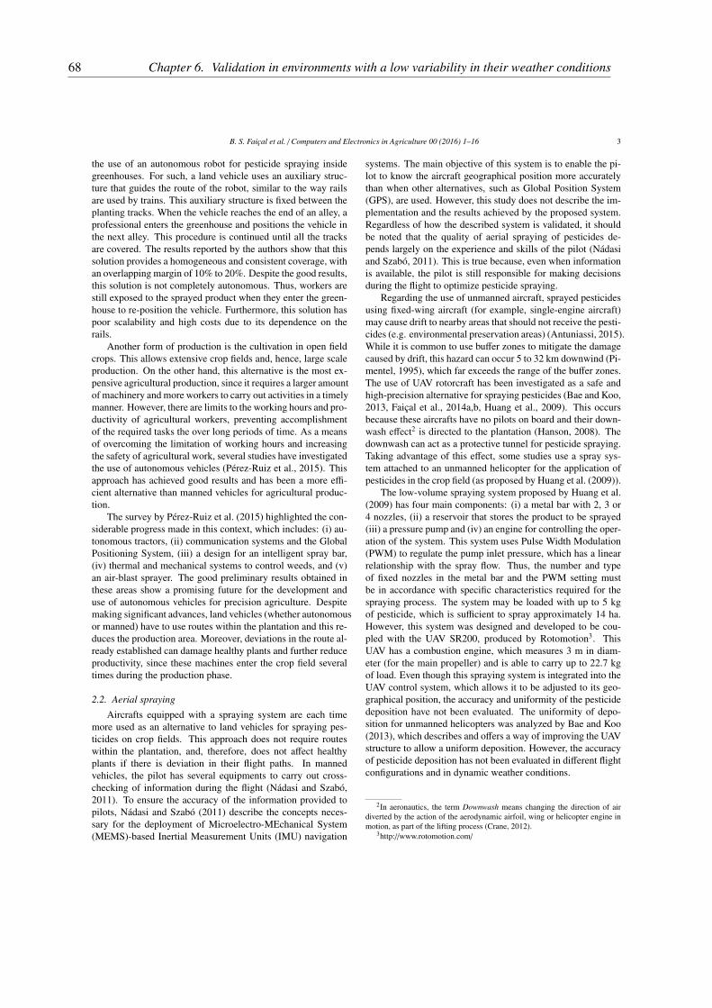
B. S. Faiçal et al. / Computers and Electronics in Agriculture 00 (2016) 1–16 3
the use of an autonomous robot for pesticide spraying insidegreenhouses. For such, a land vehicle uses an auxiliary struc-ture that guides the route of the robot, similar to the way railsare used by trains. This auxiliary structure is fixed between theplanting tracks. When the vehicle reaches the end of an alley, aprofessional enters the greenhouse and positions the vehicle inthe next alley. This procedure is continued until all the tracksare covered. The results reported by the authors show that thissolution provides a homogeneous and consistent coverage, withan overlapping margin of 10% to 20%. Despite the good results,this solution is not completely autonomous. Thus, workers arestill exposed to the sprayed product when they enter the green-house to re-position the vehicle. Furthermore, this solution haspoor scalability and high costs due to its dependence on therails.
Another form of production is the cultivation in open fieldcrops. This allows extensive crop fields and, hence, large scaleproduction. On the other hand, this alternative is the most ex-pensive agricultural production, since it requires a larger amountof machinery and more workers to carry out activities in a timelymanner. However, there are limits to the working hours and pro-ductivity of agricultural workers, preventing accomplishmentof the required tasks the over long periods of time. As a meansof overcoming the limitation of working hours and increasingthe safety of agricultural work, several studies have investigatedthe use of autonomous vehicles (Pérez-Ruiz et al., 2015). Thisapproach has achieved good results and has been a more effi-cient alternative than manned vehicles for agricultural produc-tion.
The survey by Pérez-Ruiz et al. (2015) highlighted the con-siderable progress made in this context, which includes: (i) au-tonomous tractors, (ii) communication systems and the GlobalPositioning System, (iii) a design for an intelligent spray bar,(iv) thermal and mechanical systems to control weeds, and (v)an air-blast sprayer. The good preliminary results obtained inthese areas show a promising future for the development anduse of autonomous vehicles for precision agriculture. Despitemaking significant advances, land vehicles (whether autonomousor manned) have to use routes within the plantation and this re-duces the production area. Moreover, deviations in the route al-ready established can damage healthy plants and further reduceproductivity, since these machines enter the crop field severaltimes during the production phase.
2.2. Aerial spraying
Aircrafts equipped with a spraying system are each timemore used as an alternative to land vehicles for spraying pes-ticides on crop fields. This approach does not require routeswithin the plantation, and, therefore, does not affect healthyplants if there is deviation in their flight paths. In mannedvehicles, the pilot has several equipments to carry out cross-checking of information during the flight (Nádasi and Szabó,2011). To ensure the accuracy of the information provided topilots, Nádasi and Szabó (2011) describe the concepts neces-sary for the deployment of Microelectro-MEchanical System(MEMS)-based Inertial Measurement Units (IMU) navigation
systems. The main objective of this system is to enable the pi-lot to know the aircraft geographical position more accuratelythan when other alternatives, such as Global Position System(GPS), are used. However, this study does not describe the im-plementation and the results achieved by the proposed system.Regardless of how the described system is validated, it shouldbe noted that the quality of aerial spraying of pesticides de-pends largely on the experience and skills of the pilot (Nádasiand Szabó, 2011). This is true because, even when informationis available, the pilot is still responsible for making decisionsduring the flight to optimize pesticide spraying.
Regarding the use of unmanned aircraft, sprayed pesticidesusing fixed-wing aircraft (for example, single-engine aircraft)may cause drift to nearby areas that should not receive the pesti-cides (e.g. environmental preservation areas) (Antuniassi, 2015).While it is common to use buffer zones to mitigate the damagecaused by drift, this hazard can occur 5 to 32 km downwind (Pi-mentel, 1995), which far exceeds the range of the buffer zones.The use of UAV rotorcraft has been investigated as a safe andhigh-precision alternative for spraying pesticides (Bae and Koo,2013, Faiçal et al., 2014a,b, Huang et al., 2009). This occursbecause these aircrafts have no pilots on board and their down-wash effect2 is directed to the plantation (Hanson, 2008). Thedownwash can act as a protective tunnel for pesticide spraying.Taking advantage of this effect, some studies use a spray sys-tem attached to an unmanned helicopter for the application ofpesticides in the crop field (as proposed by Huang et al. (2009)).
The low-volume spraying system proposed by Huang et al.(2009) has four main components: (i) a metal bar with 2, 3 or4 nozzles, (ii) a reservoir that stores the product to be sprayed(iii) a pressure pump and (iv) an engine for controlling the oper-ation of the system. This system uses Pulse Width Modulation(PWM) to regulate the pump inlet pressure, which has a linearrelationship with the spray flow. Thus, the number and typeof fixed nozzles in the metal bar and the PWM setting mustbe in accordance with specific characteristics required for thespraying process. The system may be loaded with up to 5 kgof pesticide, which is sufficient to spray approximately 14 ha.However, this system was designed and developed to be cou-pled with the UAV SR200, produced by Rotomotion3. ThisUAV has a combustion engine, which measures 3 m in diam-eter (for the main propeller) and is able to carry up to 22.7 kgof load. Even though this spraying system is integrated into theUAV control system, which allows it to be adjusted to its geo-graphical position, the accuracy and uniformity of the pesticidedeposition have not been evaluated. The uniformity of depo-sition for unmanned helicopters was analyzed by Bae and Koo(2013), which describes and offers a way of improving the UAVstructure to allow a uniform deposition. However, the accuracyof pesticide deposition has not been evaluated in different flightconfigurations and in dynamic weather conditions.
2In aeronautics, the term Downwash means changing the direction of airdiverted by the action of the aerodynamic airfoil, wing or helicopter engine inmotion, as part of the lifting process (Crane, 2012).
3http://www.rotomotion.com/
68 Chapter 6. Validation in environments with a low variability in their weather conditions

B. S. Faiçal et al. / Computers and Electronics in Agriculture 00 (2016) 1–16 4
2.3. Different approaches of spraying
It must be observed that the terrestrial approach employsvehicles that use roads within the plantation to spray the pes-ticide throughout the cultivation, which can result in soil com-paction. The aerial approach, on the other hand, does not re-quire pathways within the plantation and enables the pesticideto be sprayed from a larger distance (when compared to the ter-restrial approach). In the latter approach, there is an increase inthe drift of pesticides to neighboring areas (Antuniassi, 2015).The drift of pesticides into the environment can cause seriousharmful effects on flora and fauna, by contaminating preserva-tion areas and destroying wildlife. Moreover, even though thepesticide is deposited within the crop field, wheather condic-tions can spread pesticides to other areas, expose agriculturalworkers and the population (end-consumers) to inappropriateand prolonged contact with the products, causing serious healthdamages (Dhouib et al., 2016).
An architecture based on UAV and wireless sensor networkshas been investigated and proposed to reduce the risks of pes-ticide drifts outside of the target area and to avoid overlap-ping sprayed areas, by ensuring more precise deposition of thesprayed products. This approach can reduce the amount of pes-ticides used in agricultural production, without damaging thecrop yield.
3. Proposed approach for UAV and WSN for aerial pesti-
cide spraying
3.1. Overview and problem statement
Previous works have investigated the use of UAVs to im-prove the quality and amount of crop production in several agri-cultural activities (Huang et al., 2009, Valente et al., 2011). Oneof the most important of these activities is pesticide sprayingfor pest control. This activity has had a great influence on thequality and yield of cultivated crops, since pesticides are usedto create a near-optimum environment and their inappropriateuse can cause environmental and economic damage and leadto health problems. Figure 1 shows the problem addressed inthis paper, resulting from inaccurate spraying pesticides. Theweather conditions in the crop field cause pesticide to drift outof the target area. This results in extensive damage, such asoverlapping pesticides, non sprayed regions and contaminationof rivers, forests and inhabited areas.
3.2. First attempt to solve the problem
In order to deal with the previously mentioned problem,Faiçal et al. (2014b) proposed an architecture based on UAVand WSN for aerial spraying of pesticides in agricultural fields.This architecture enables an UAV to adjust its route to the con-centration of deposited pesticides. This information is obtainedthrough a WSN deployed in a matrix format covering the cropsin the field. According to experimental results, this architecturemakes the spraying process more precise and safer than previ-ous approaches commonly employed for aerial spraying, wherea manned aircraft is used without the feedback of informationabout pesticide deposition.
Figure 1. Problem statement: drift of pesticides from the target crop field indynamic environments (e.g. a change of wind speed and direction).
The application scenario exploited by Faiçal et al. (2014b)is shown in Figure 2. In this figure, the UAV is a spraying ele-ment equipped with a programmable trigger system. The con-trol system divides the crop field into parallel spraying tracksand defines a flight path so the UAV can fly over the centerof these tracks when spraying pesticide (see Figure 2(a)). Theused architecture allows the spraying process to be interruptedat any time for refueling or pesticide recharge, and resumed atthe exact same point. Each track is positioned in a way thatpairs of sensors can be placed within the limits of its width.Thus, as the track is covered during the spraying process, theUAV communicates with the sensors in 10 second intervals (seeFigure 2(b)). During the communication, the sensor nodes sendinformation to the UAV control system, such as the concen-tration of pesticides and weather conditions (wind speed anddirection). If the sensors report an imbalance in the pesticidedeposition that exceeds a fixed threshold, the UAV control sys-tem adjusts the flight path to provide a uniform deposition.
The sensor nodes have a specific hardware to capture infor-mation used by the UAV (wind speed and direction and pesti-cide deposition). To obtain wind-related information, an anemo-meter can be installed above the plantation height. For the pes-ticide deposition, a specific chemical sensor may be needed todetect the presence of the active substance used in the pesti-cide. This is possible because when the pulverized product ap-proaches the crop, the chemical sensors identify the presence ofa specific active substance and react to it. It is important to ob-serve that the calibration of the chemical sensors depends on themodel and which active substance is used; the calibration must,therefore, be performed in the actual deployment of WSN.
In addition to the WSN operation, the arrangement of sensornodes (in matrix format) allows the UAV’s on-board computerto compare information from two neighboring nodes. This ispossible because the definition of the position of the nodes takesinto account the range of spraying. Thus, the width of the sprayranges covers two neighboring nodes sensors (in parallel). Fi-nally, regarding WSN architecture, the UAV is considered a mo-bile node and it is responsible for requesting information fromspecific fixed sensors (according to their position in the cropfield) at periodic time intervals.
69
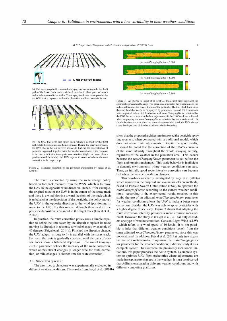
B. S. Faiçal et al. / Computers and Electronics in Agriculture 00 (2016) 1–16 5
(a) The target crop field is divided into spraying tracks to guide the flightpath of the UAV. Each track is defined in order to allow pairs of sensornodes to be covered in its width. These spray tracks are made possible bythe WSN that is deployed within the plantation and have a matrix format.
(b) The UAV flies over each spray track, which is defined for the flightpath while the pesticides are being sprayed. During the spraying process,the UAV checks the last covered sensors to find out the concentration ofpesticide deposited, together with the weather conditions. If the responseto the query indicates inadequate concentration (higher or lower than apredetermined threshold), the UAV adjusts its route to balance the con-centration in the target crop.
Figure 2. Standard operation of the proposed architecture by Faiçal et al.(2014b).
The route is corrected by using the route change policybased on feedback received from the WSN, which is to movethe UAV in the opposite wind direction. Hence, if for example,the original route of the UAV is in the center of the spray trackand there is a wind blowing toward the right of the track whichis unbalancing the deposition of the pesticide, the policy movesthe UAV in the opposite direction to the wind (positioning itsroute to the left). By this means, although there is drift, thepesticide deposition is balanced in the target track (Faiçal et al.,2014b).
In practice, the route correction policy uses a simple equa-tion to define the time taken by the aircraft to update its routemoving its direction in response to wind changes by an angle of45 degrees (Faiçal et al., 2014b). Finished the direction change,the UAV adapts its route to fly in parallel with the spray track.For such, the route is gradually corrected until the pairs of sen-sor nodes show a balanced deposition. The routeChanging-
Factor parameter defines the intensity of the route correction,which allows abrupt changes (a longer time for route correc-tion) or mild changes (a shorter time for route correction).
3.3. Discussion of results
The described architecture was experimentally evaluated indifferent weather conditions. The results from Faiçal et al. (2014b)
(a) routeChangingFactor = 3.000
(b) routeChangingFactor = 6.000
(c) routeChangingFactor = 7.164
Figure 3. As shown in Faiçal et al. (2014a), these heat maps represent thechemicals sprayed on the crop. The green area illustrates the plantation and thered area illustrates the concentration of the pesticide. The thin black lines showthe crop field that needs to be sprayed by pesticides. (a) and (b) Evaluationswith empirical values. (c) Evaluation with routeChangingFactor obtained bythe PSO. It can be seen that the best adjustments in the UAV track are achievedwhen employing the routeChangingFactor obtained by the metaheuristic. Itshould be observed that when the simulation starts with wind, the UAV alwaysstarts the dispersion of the chemicals outside the boundary.
show that the proposed architecture improved the pesticide spray-ing accuracy, when compared with a traditional model, whichdoes not allow route adjustments. Despite the good results,it should be noted that the correction of the UAV’s course isof the same intensity throughout the whole spraying activity,regardless of the weather in the plantation area. This occursbecause the routeChangingFactor parameter is set before theflight and remains unchanged. This static behavior is inefficientin dynamic environments, where weather conditions can vary.Thus, an initially good route intensity correction can becomebad when the weather condition changes. .
This drawback was partly investigated by Faiçal et al. (2014a),which resulted in the proposal and evaluation of new methods,based on Particle Swarm Optimization (PSO), to optimize therouteChangingFactor according to the current weather condi-tions. According to the experimental results obtained in thisstudy, the use of an adjusted routeChangingFactor parameterfor weather conditions allows the UAV to make a better routecorrection. Besides, the UAV was able to spray pesticides witha higher degree of accuracy. Figure 3 shows that adapting theroute correction intensity provides a more accurate measure-ment. However, the study in (Faiçal et al., 2014a) only consid-ers one type of weather condition, Constant Light Wind (CLW)- which refers to a wind speed of 10 km/h. It is not possi-ble to infer that different weather conditions benefit from thesame adjusted routeChangingFactor parameter, since this wasnot evaluated. In addition, Faiçal et al. (2014a) only investigatethe use of a metaheuristic to optimize the routeChangingFac-
tor parameter for the weather condition; it did not study it as acomplete system. To overcome the previously mentioned lim-itations, this paper proposes the AdEn system, a complete sys-tem to optimize UAV flight trajectories where adjustments aremade in response to changes in the weather. It must be observedthat AdEn is evaluated in different weather conditions and withdifferent computing platforms.
70 Chapter 6. Validation in environments with a low variability in their weather conditions

B. S. Faiçal et al. / Computers and Electronics in Agriculture 00 (2016) 1–16 6
4. The AdEn System - Adaptation to the Environment
The Adaptation to the Environment system (AdEn) is com-posed by two main components: (i) Collector and Actuating(CollAct), and (ii) OPTImization Core (OPTIC). The first com-ponent collects weather information and updates the settings ofthe UAV control system. The second component is responsiblefor adapting the routeChangingFactor parameter to changes inthe weather conditions. It defines the required route correction.
Figure 4 displays the main features of the AdEn system andthe computing platforms where they run, including their inter-nal interactions. CollAct runs on a computer system embeddedin the UAV, while OPTIC runs on the Aircraft Control Station.It is worth pointing out that both components (CollAct and OP-TIC) run above the Operating System (OS) and in parallel withother processes in their respective computing platforms. TheAdEn system is designed to interact with the UAV route correc-tion system (using CollAct to update the flight configurations),making it less dependent on other processes and libraries.
CollAct uses an existing communication link with the WSNto collect weather information about the crop field being sprayed.This information is transmitted to the OPTIC element via awireless communication link that exists between the UAV andthe Control Station. At this time, the OPTIC element is exe-cuted and a new value for the routeChangingFactor parameteris transmitted back to CollAct, which updates the value of therule-based parameter adjustment route of the aircraft. The set-tings are loaded whenever the UAV starts to spray a new sub-area.
Figure 4. Elements of the AdEn system (CollAct and OPTIC) in their respec-tive computing platforms, together with the components of the architecture pro-posed by Faiçal et al. (2014b).
As previously mentioned, AdEN uses a track structure toguide the UAV’s flight path. AdEN creates sequential sub-areas (regions of interest), forming logical divisions at the spraytracks This division defines the regions that will have sensornodes, which can be queried for weather information and whereeach optimized value (adjusted intensity) is employed. In thespraying of each track, while a sub-area is sprayed (with thestandard operation - spraying and course correction with an in-tensity set at the beginning of the sub-area),the intensity adjust-ment (AdEn system) uses weather information from the nextsub-area. This process runs sequentially for each sub-area ofthe track until the end of the spraying process. The spraying ofa crop field is concluded after all the tracks are sprayed by theUAV. Figure 5 shows the logical divisions of the spray tracks,
which create sub-areas of interest, and the rest of the crop fieldin tracks (those without divisions to make it easier to understandthe process).
Figure 5. The spray track is divided into sub-areas of interest, which define thenode sensors that will be queried for weather information and the area whereeach intensity is used. The current sprayed area is highlighted in the wholearea to be sprayed. The wireless communication symbols represent the queriesabout the deposition of the pesticide. Although the query about the weather,used to adjust the intensity of the correction, is not shown (to keep the picturemore clear), it is performed with the sensor nodes in the next sub-area to besprayed.
The routeChangingFactor parameter is updated during thetransition between the current sprayed sub-area and the sub-sequent sub-area. A procedure based on space-time betweenthe UAV and the crop field was used by the AdEN system tosynchronize the UAV activities. Figure 6 shows the sequenceof steps executed by the AdEn system while spraying a track.These steps are performed in parallel with the operation of thearchitecture proposed by Faiçal et al. (2014b). Thus, the AdEnsystem runs in parallel with the original architecture, by adapt-ing its route adjustment policy to environmental weather con-ditions without the route correction system being aware of thisprocess.
Figure 6. Spatio-temporal representation of actions taken by AdEn. It is im-portant to observe that the best route correction intensity found is used in thefollowing sub-area, in which the processing steps are executed (e.g., the resultof the 1st processing is used in the 1st sub-area). Initially, the CollAct elementqueries the sensors from the next sub-area by asking about the weather. It thensends this information to the OPTIC element in the Control Station. After theoptimization of the routeChangingFactor parameter, the best value is transmit-ted back to CollAct (in the UAV). Finally, CollAct updates the route adjustmentpolicy with the received value.
Hence, the activities of the proposed system can be summa-rized as follows: (i) collecting the weather information aboutthe next target sub-area; (ii) optimizing the parameter for theweather and; (iii) updating the parameter value of the routeChang-
71

B. S. Faiçal et al. / Computers and Electronics in Agriculture 00 (2016) 1–16 7
ingFactor when setting the route adjustment policy. As shownin Figure 6, the three activities are carried out sequentially toobtain a new parameter value of the routeChangingFactor whichcan be used in the next sub-area. However, in the first sub-areaof the spray track, AdEn performs all the activities before start-ing the spraying. In this case, the UAV control system receivesa signal to wait for the routeChangingFactor parameter to beupdated.
4.1. Querying weather information and updating the route ad-
justment policy
Querying the sensor nodes located in the next sub-area isperformed throughout the wireless communication between UAVand WSN. The querying process executed by the AdEn systemfor nodes in the WSN, is performed by giving information ofthe geographic coordinates that define the next target sub-area.Since the sensor nodes have information about their locations,the ones that are deployed within the next sub-area are ableto respond to the requests sent by AdEn. Response messagessent by the sensor nodes are destined to the AdEn embeddedsystem in the UAV and have the weather information of thesub-area. This information might be the average of the previ-ously acquired sensor data. On receiving these messages, theAdEn system calculates the average weather condition of thesub-area and transmits this information to the OPTIC elementin the Control Station.
After sending the information to the OPTIC element, Col-lAct remains on standby. This state is changed when it receivesa message from OPTIC with a new value for the routeChang-
ingFactor parameter or in case of a timeout, which can be setaccording to how long the UAV will take to arrive at the endof the current sub-area. In the event of a failure that prevents amessage sent by the OPTIC element (e.g. signal loss from thetelemetry system) from being received, two backup settings canbe used, (i) keep the last received value and use it for the nextsub-areas until the problem has been fixed or (ii) set a defaultvalue to be used as a routeChangingFactor parameter until amessage from the OPTIC element is received.
Finally, the adaptation ends when the UAV reaches the endof the target sub-area and CollAct updates the value of the route-
ChangingFactor parameter in the UAV route correction system.This value is used in the next sub-area to be sprayed, whileanother intensity adjustment cycle is executed in the next sub-area.
4.2. Optimization of the routeChangingFactor parameter to wea-
ther conditions
As previously described, the optimization of the intensityof route correction is carried out by the OPTIC element, whichruns in the control station while the previous sub-area was beingsprayed. Although the spraying architecture executes the coursecorrection autonomously, the Control Station enables a humanoperator to take control of the aircraft at any time. Moreover,as previously explained, the control station can also be used asan additional computing platform for processing the decision-making of the UAV control system.
In order to achieve an accurate global spraying, the eval-uation of the pulverization accuracy was divided into severalsub-problems, each one concerned with the evaluation of theaccuracy of the deposition into a sub-area. The combinationof adjustments performed in each sub-area allows a better so-lution to the large (global) problem, which is the adjustment ofthe intensity of route correction during the complete sprayingof the agricultural field. Even if the pulverization in each sub-area is highly accurate, it is still possible to achieve a globallyaccurate spraying. The use of sub-areas to evaluate the sprayingaccuracy can reduce the overall computational cost, making theproposed solution computationally efficient during the onlineprocessing.
The optimization problem addressed by the AdEn system(specifically the OPTIC element) is to find non-optimal valuesof intensity to adjust the route of the UAV in order to minimizethe function:
Fitness =∑ϑ −∑ν
where∑ϑ is the sum of all the pesticide sprayed and
∑ν
is the sum of pesticide deposited in the correct region. Thus,this function calculates the amount of pesticide deposited out-side the target area. Consequently, the optimal route correctionintensity is the one that minimize this objective function (thelower the value, the better the fitness).
In practice, the intensity of the route adjustment is a valueinside a search space that allows for different settings (e.g. abrupt,smooth and moderate). The search space is defined by:
routeChangingFactor = {x ∈ R | 1.0 ≤ x ≤ 10.0}
Figure 7 shows the operations of OPTIC in the ControlStation, with the interactions between its components (Core,Computer Model of the Environment and Metaheuristic). Ini-tially, the Core receives weather information collected by Col-lAct through the communication link between the Control Sta-tion and the UAV (Step 1). Next, it incorporates this informa-tion in a computer model that is specifically designed for thegiven environment (Step 2) and runs a metaheuristic (Step 3).The metaheuristic evaluates various solutions in the computa-tional model (Step 4) to find a route correction intensity valuethat is close to ideal. The best value found (non-optimal) bythe metaheuristic is sent to the Core (Step 5), which sends thevalue to CollAct (Step 6) by the same communication link usedto receive the weather information.
The computer model used by OPTIC was first described inFaiçal et al. (2014b), where it was used to evaluate the accu-racy of the platform for route adjustment. However, this modelwas adapted to run without the occurrence of stochastic interfer-ence between the evaluations carried out during the executionof the metaheuristic. This behavior allows a fair comparison be-tween the tested intensities. Yet, the computational model usedconsiders the pesticide spraying architecture without the AdEnsystem, as this is executed transparently and in parallel with theoriginal architecture.
OMNeT++4 was used to implement the computational model.
4OMNeT++ Network Simulation Framework, http://www.omnetpp.org
72 Chapter 6. Validation in environments with a low variability in their weather conditions

B. S. Faiçal et al. / Computers and Electronics in Agriculture 00 (2016) 1–16 8
Figure 7. Execution of OPTIC element in the Control Station to optimize therouteChangingFactor parameter for weather measured by the WSN.
This software is a simulator of discrete events based on the C++language to model networks, multiprocessors and other dis-tributed and parallel systems (Varga, 2010). OMNeT++ can beused to model several types of networks (for example, networksof queues, wireless and peer-to-peer types) (Klaus Wehrle, 2005).Because of its generic design, OMNeT++ has several frame-works established for specific networks, such as Mixim5 formodeling wireless networks. This framework provides detailedmodels for wireless channels, wireless connections, mobilitymodels, models for dealing with obstacles and several com-munication protocols, especially for MAC (Köpke et al., 2008)layer.
Additionally, the computational model used allows the useof different dispersion models to calculate the physical processof transport and transformation of the product until it reachesthe culture. This modular structure allows assessments to becarried out continuously to make it increasingly accurate againstthe real process without losing deployments ever undertaken.In the current implementation, the Chemical Dispersion Mod-ule calculates the fall of the chemical through the position andtime of fall of each drop. This chemical dispersion is basedon a simplified model of pollutants, which consider (1) the ini-tial velocity vector of the particle, when sprayed; (2) the windspeed vector; and (3) gravity. Calculations are performed forall instants of time for each drop of the pulverized product un-til reaching the culture (Faiçal et al., 2014b). This dispersionmodel, although simple, is satisfactory at this stage because thegoal is to optimize UAV route. However, it is important to notethat the dispersion model can be exchanged for more accuratemodels according to future research needs.
Each solution found by the metaheuristic used is evaluatingaccording to the quality its associated route. The quality ofa solution is inversely proportional to the amount of pesticidedeposited outside the target region. Thus, the lower the amountof pesticide outside the target area, the better the quality of theroute. A computational model uses an objective function to
5MiXiM project, http://mixim.sourceforge.net
evaluate the intensity of route changes and return the best valuefound for the current weather. The following sections describethe methodology used to assess the effectiveness of the AdEnsystem.
5. Setting the Metaheuristic and Evaluating the AdEn Sys-
tem
The optimization of the routeChangingFactor parameter isessential for the adaptation of the route correction of the origi-nal architecture (proposed by Faiçal et al. (2014b)) to the weatherconditions. Several metaheuristic were investigated to select themost efficient for this task. The progress made in the use of theroute correction intensity adapted to the weather conditions indifferent scenarios was also evaluated. Due to the short timeavailable for transmitting weather information (Faiçal et al.,2014b) and the need to concentrate on the behavior of the eval-uated metaheuristics, it is assumed that the weather informationwas already incorporated in the environmental computer model.The, the main focus of this article is on assessing the perfor-mance of the metaheuristics. This scenario is similar to thatemployed in Faiçal et al. (2014a), used here as a benchmark toshow the progress achieved in this study.
The experiments are divided into three complementary pha-ses. Initially, Grid Search is used to tune the main parametersof the metaheuristic (see Table 2). Grid search is used to im-prove the convergence rate of the metaheuristic. In the sec-ond phase, the best settings for each metaheuristic is executedon an embedded computing platform. The performance of themetaheuristics in a UAV equipped with embedded hardware isassesses and compared with the performance achieved by thesame metaheuristics in a computer platform used in the ControlStation. Finally, the accuracy of the spraying is evaluated toassess if these metaheuristics can be used in different weatherconditions (winds of 10 and 20 km/h).
The following metaheuristics were investigated for this stu-dy: (i) Particle Swarm Optimization – PSO (Eberhart et al.,2001, Engelbrecht, 2006, Faiçal et al., 2014a); (ii) Genetic Al-gorithm – GA (Faiçal et al., 2014, Holland John, 1975); (iii)Hill Climbing with the Next-Ascent strategy - NAHC (Forrestand Mitchell, 1993, Muhlenbein, 1991); and (iv) Simulated An-nealing – SA (Kirkpatrick et al., 1983). These metaheuristicsare widely used in the optimization literature with good re-sults in several applications. It must be emphasized that theimplementation of the metaheuristics was based on the articlewhere they were published and their source codes are availableat http://goo.gl/tT6qsf. Additional information on the flight con-ditions of the UAV and about the environment for the develop-ment and evaluation of AdEn system can be seen in Table 1.
The main results illustrating the progress made in this workare described next. The results obtained by the GA are high-lighted, because, together with the PSO results, they were thebest results achieved. PSO was used in the experiments re-ported in Faiçal et al. (2014a). It is important to notice that twoPSO configurations were used in the experiments, (i) exactly asproposed in our previous work and; (ii) with the same imple-
73
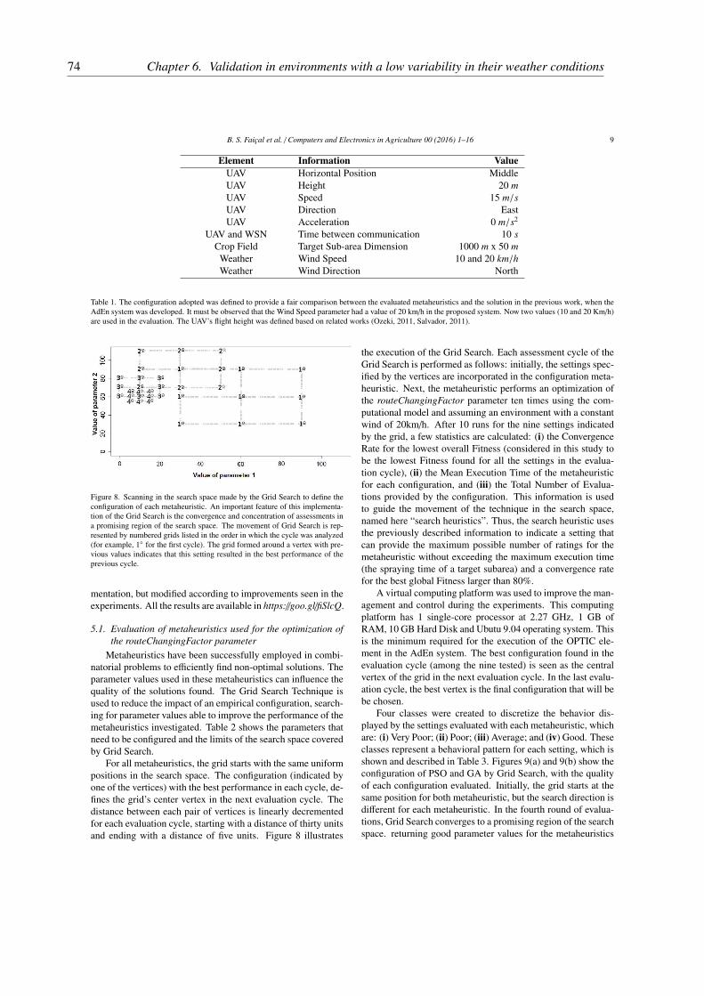
B. S. Faiçal et al. / Computers and Electronics in Agriculture 00 (2016) 1–16 9
Element Information Value
UAV Horizontal Position MiddleUAV Height 20 m
UAV Speed 15 m/s
UAV Direction EastUAV Acceleration 0 m/s2
UAV and WSN Time between communication 10 s
Crop Field Target Sub-area Dimension 1000 m x 50 m
Weather Wind Speed 10 and 20 km/h
Weather Wind Direction North
Table 1. The configuration adopted was defined to provide a fair comparison between the evaluated metaheuristics and the solution in the previous work, when theAdEn system was developed. It must be observed that the Wind Speed parameter had a value of 20 km/h in the proposed system. Now two values (10 and 20 Km/h)are used in the evaluation. The UAV’s flight height was defined based on related works (Ozeki, 2011, Salvador, 2011).
Figure 8. Scanning in the search space made by the Grid Search to define theconfiguration of each metaheuristic. An important feature of this implementa-tion of the Grid Search is the convergence and concentration of assessments ina promising region of the search space. The movement of Grid Search is rep-resented by numbered grids listed in the order in which the cycle was analyzed(for example, 1◦ for the first cycle). The grid formed around a vertex with pre-vious values indicates that this setting resulted in the best performance of theprevious cycle.
mentation, but modified according to improvements seen in theexperiments. All the results are available in https://goo.gl/fiSlcQ.
5.1. Evaluation of metaheuristics used for the optimization of
the routeChangingFactor parameter
Metaheuristics have been successfully employed in combi-natorial problems to efficiently find non-optimal solutions. Theparameter values used in these metaheuristics can influence thequality of the solutions found. The Grid Search Technique isused to reduce the impact of an empirical configuration, search-ing for parameter values able to improve the performance of themetaheuristics investigated. Table 2 shows the parameters thatneed to be configured and the limits of the search space coveredby Grid Search.
For all metaheuristics, the grid starts with the same uniformpositions in the search space. The configuration (indicated byone of the vertices) with the best performance in each cycle, de-fines the grid’s center vertex in the next evaluation cycle. Thedistance between each pair of vertices is linearly decrementedfor each evaluation cycle, starting with a distance of thirty unitsand ending with a distance of five units. Figure 8 illustrates
the execution of the Grid Search. Each assessment cycle of theGrid Search is performed as follows: initially, the settings spec-ified by the vertices are incorporated in the configuration meta-heuristic. Next, the metaheuristic performs an optimization ofthe routeChangingFactor parameter ten times using the com-putational model and assuming an environment with a constantwind of 20km/h. After 10 runs for the nine settings indicatedby the grid, a few statistics are calculated: (i) the ConvergenceRate for the lowest overall Fitness (considered in this study tobe the lowest Fitness found for all the settings in the evalua-tion cycle), (ii) the Mean Execution Time of the metaheuristicfor each configuration, and (iii) the Total Number of Evalua-tions provided by the configuration. This information is usedto guide the movement of the technique in the search space,named here “search heuristics”. Thus, the search heuristic usesthe previously described information to indicate a setting thatcan provide the maximum possible number of ratings for themetaheuristic without exceeding the maximum execution time(the spraying time of a target subarea) and a convergence ratefor the best global Fitness larger than 80%.
A virtual computing platform was used to improve the man-agement and control during the experiments. This computingplatform has 1 single-core processor at 2.27 GHz, 1 GB ofRAM, 10 GB Hard Disk and Ubutu 9.04 operating system. Thisis the minimum required for the execution of the OPTIC ele-ment in the AdEn system. The best configuration found in theevaluation cycle (among the nine tested) is seen as the centralvertex of the grid in the next evaluation cycle. In the last evalu-ation cycle, the best vertex is the final configuration that will bebe chosen.
Four classes were created to discretize the behavior dis-played by the settings evaluated with each metaheuristic, whichare: (i) Very Poor; (ii) Poor; (iii) Average; and (iv) Good. Theseclasses represent a behavioral pattern for each setting, which isshown and described in Table 3. Figures 9(a) and 9(b) show theconfiguration of PSO and GA by Grid Search, with the qualityof each configuration evaluated. Initially, the grid starts at thesame position for both metaheuristic, but the search direction isdifferent for each metaheuristic. In the fourth round of evalua-tions, Grid Search converges to a promising region of the searchspace. returning good parameter values for the metaheuristics
74 Chapter 6. Validation in environments with a low variability in their weather conditions

B. S. Faiçal et al. / Computers and Electronics in Agriculture 00 (2016) 1–16 10
Metaheuristic Parameters Lower Limit Upper Limit
GA Individuals and Generations 1 120PSO Particles and Interactions 1 120HC Mutations and Jumps 1 120SA Disorders and Iterations 1 120
Table 2. Parameters and limits of the search space used by the Grid Search for configuring the metaheuristics.
Symbol Name Description
△ Very Poor (VP) Average Runtime higher than available for optimizing the parameter× Poor (P) Appropriate Average Runtime; Convergence Rate less than 0.5+ Average (A) Appropriate Average Runtime; Convergence Rate between 0.5 and 0.8• Good (G) Appropriate Average Runtime; Convergence Rate higher than 0.8
Table 3. Discretization of the performance of metaheuristics using the settings evaluated by the Grid Search.
(a) Search for configuring the PSO.
(b) Search for configuring the GA.
Figure 9. Search performed by the Grid Search for configuring the GA andPSO, evaluated to optimize routeChangingFactor parameter.
(indicated by Good class).Grid Search indicated settings with “Good” class for both
metaheuristics, two for PSO and three for GA. These settingsare shown in Figure 9(a) and 9(b) and marked with •. It ispossible to see the behavior of the five settings in Table 4, whichare: (i) for the PSO, PARTX_ITEY, where X is the number ofparticles that compose the swarm and Y is the total number ofiterations; and (ii) for the GA, INDX_GENY, where X is to thenumber of individuals that comprise the population and Y is tothe total number of generations.
Although all the settings in Table 4 comply with the criteriaset out in the search heuristics and can be classified as “Good”,the PART45_ITE5 settings for PSO, and IND10_GEN25, forGA, were better than the other settings. This can be explainedby the fact that they have the best convergence rates and furtherevaluations were conducted during the execution of their meta-heuristics. Even tough, these settings keep a reasonable MeanExecution Time. Given the characteristics of environment andflight, the Mean Execution Time is assumed to be reasonable ifit is below 66.667 s. The maximum time (∆) that the executionof the metaheuristic can take is obtained by the Equation:
∆ =α
ν
where α is the length of the sub-area in meters and ν is the UAVspeed in meters per second.
Another investigated approach explores the search spaceand look for settings similar to those highlighted in Table 4,which are later evaluated. To find these new settings, it is nec-essary to define which numerical combinations of the two pa-rameters of each metaheuristic (PSO and GA) result in the samenumber of evaluations as the best settings found by Grid Search.To find the new configurations that result in the same amount ofevaluations, a procedure calculates {i, j} where i × j == Over-
allEvaluation. In this case, OverallEvaluation is the maximumnumber of evaluations allowed for the new settings and i andj represent the metaheuristic parameters. When a numericalcombination satisfies this condition, the result is validated. In
75
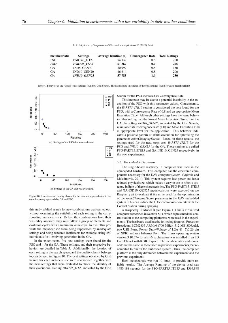
B. S. Faiçal et al. / Computers and Electronics in Agriculture 00 (2016) 1–16 11
metaheuristic Settings Average Runtime (s) Convergence Rate Total Ratings
PSO PART40_ITE5 54.132 0.8 200PSO PART45_ITE5 61.369 0.9 225
GA IND5_GEN30 30.992 0.8 150GA IND10_GEN20 46.614 0.8 200GA IND10_GEN25 57.785 1.0 250
Table 4. Behavior of the “Good” class settings found by Grid Search. The highlighted lines refer to the best settings found for each metaheuristic.
(a) Settings of the PSO that was evaluated.
(b) Settings of the GA that was evaluated.
Figure 10. Locations and quality classes for the new settings evaluated in thecomplementary approach by GA and PSO.
this study, a blind search for new combinations was carried out,without examining the suitability of each setting in the corre-sponding metaheuristics. Before the combinations have theirfeasibility assessed, they must allow a group of elements andevolution cycles with a minimum value equal to five. This pre-vents the metaheuristic from being suppressed by inadequatesettings and being rendered inefficient; for example, using 250individuals for 1 evolving generation in the GA.
In the experiments, five new settings were found for thePSO and 4 for the GA. These settings, and their respective be-havior, are detailed in Table 5. Additionally, the location ofeach setting in the search space, and the quality class it belongsto, can be seen in Figure 10. The best settings obtained by GridSearch for each metaheuristic were re-executed together withthe new settings that were evaluated to check the stability oftheir executions. Setting PART45_ITE5, indicated by the Grid
Search for the PSO increased its Convergence Rate.This increase may be due to a potential instability in the ex-
ecution of the PSO with this parameter values. Consequently,the PART15_ITE15 setting is considered the best found for thePSO, with a Convergence Rate of 0.8 and an appropriate MeanExecution Time. Although other settings have the same behav-ior, this setting had the lowest Mean Execution Time. For theGA, the setting IND10_GEN25, indicated by the Grid Search,maintained its Convergence Rate (1.0) and Mean Execution Timeat appropriate level for the application. This behavior indi-cates a possible pattern of stable execution for optimizing theparameter routeChangingFactor. Based on these results, thesettings used for the next steps are: PART15_ITE15 for thePSO and IND10_GEN25 for the GA. These settings are calledPSO-PART15_ITE15 and GA-IND10_GEN25 respectively, inthe next experiments.
5.2. The embedded hardware
The single-board raspberry Pi computer was used in theemnbedded hardware. This computer has the electronic com-ponents necessary for the UAV computer system (Vujovic andMaksimovic, 2014). This system requires low power and has areduced physical size, which makes it easy to use in robotic sys-tems. In light of these characteristics, The PSO-PART15_ITE15and GA-IND10_GEN25 metaheuristics were executed on theRaspberry pi to evaluate if it can be used for the optimizationof the routeChangingFactor parameter in the UAV embeddedsystem. This can reduce the UAV communication rate with theControl Station during spraying.
A Raspberry Pi Model B (see Figure 11) and a virtualizedcomputer (described in Section 5.1), which represented the con-trol station as the computing platforms, were used in the experi-ments. The hardware used has the following features: ProcessorBroadcom BCM2835 ARMv6 (700 MHz), 512 MB SDRAM,two USB Ports, Power Draw/Voltage of 1.2A @ 5V, 26 pinof GPIO and one Ethernet Port. The Linux operating systemversion 3.10.37+ for armv6l architecture was installed in an SDCard Class 4 with 8 GB of space. The metaheuristics and sourcecode are the same as those used in previous experiments, but re-compiled to run on the embedded system. Thus, the computerplatform is the only difference between this experiment and theprevious experiment.
Each metaheurstic was run 10 times, to provide more re-liable results. The Average Runtime of the device used was1480.198 seconds for the PSO-PART15_ITE15 and 1364.898
76 Chapter 6. Validation in environments with a low variability in their weather conditions

B. S. Faiçal et al. / Computers and Electronics in Agriculture 00 (2016) 1–16 12
Characteristics
metaheuristic Settings Average Runtime (s) Convergence Rate Total Ratings
PSO PART5_ITE45 63.156 0.8 225PSO PART9_ITE25 63.311 0.8 225PSO PART15_ITE15 63.112 0.8 225
PSO PART25_ITE9 63.148 0.6 225PSO PART45_ITE5 62.401 0.7 225GA IND5_GEN50 53.018 1.0 250GA IND10_GEN25 59.637 1.0 250
GA IND25_GEN10 63.698 1.0 250GA IND50_GEN5 65.139 0.9 250
Table 5. Parameter values evaluated in the complementary approach.
Figure 11. Embeddable device used as a computing platform to run thePSO-PART15_ITE15 and GA-IND10_GEN25 metaheuristics to optimize therouteChangingFactor parameter. This evaluation investigates whether themetaheuristics can be embedded in the UAV to reduce the rate of communi-cation with the Control Station.
Figure 12. A comparison between the Average Runtime of the metaheuristicsrunning on the Station Control and on the Raspberry PI. The difference wasconfirmed with 95% of statistical significance.
seconds for GA-IND10_GEN25. Figure 12 compares the Aver-age Runtime using Raspberry PI with the use of similar externalControl Station platform.
This comparison shows that it is not possible to run themetaheuristics in the embedded platform, since the running timewill be longer than the maximum limit required. This occurredbecause of the high processing power required to run the meta-heuristics.
Therefore, the AdEn system was kept as it is in the originalproposal. In other words, OPTIC element remains running inthe Control Station while CollAct element remains embeddedin UAVs.
5.3. Pesticide spraying with Route Correction adapted to Weather
Conditions
This section evaluated three metaheuristic variations for op-timizing the routeChangingFactor parameter optimization: (i)
GA-IND10_GEN25; (ii) PSO-PART15_ITE15; e (iii) PSO--PART5_ITE20. The first two resulted from evaluations per-formed in this paper and the third was proposed by Faiçal et al.(2014a). The weather conditions used to evaluate the accuracyof the deposition of the pesticide were as follows: (i) constantwind speed – 10 km/h and 20 km/h; and and (ii) direction ofconstant wind is in the transverse to the UAV route. A Constant
Light Wind (CLW) for a speed of 10 km/h and Constant Moder-
ate Wind (CMW) for a speed of 20 km/h were adopted (Faiçalet al., 2014b). These and other environmental characteristicsare listed in Table 1. It should be noted that the experimentsperformed in this evaluation stage were repeated 10 times.
The intensity of route correction with the worst fitness foreach weather condition was selected for the pesticide spraying.In the case of a tie between the values with the worst fitness, thechoice was made at random. By using this approach, it was pos-sible to analyze the worst case scenario that each metaheuristiccould provide for pesticide spraying, and the results with thelowest accuracy.
5.3.1. Optimization of the routeChangingFactor parameter
In the experiments for the optimization of the intensity ofthe route setting using the GA-IND10_GEN25, PSO-PART15_-ITE15 and PSO-part5_ITE20 metaheuristics, each metaheuris-tic was run in the control station for both types of weather con-ditions (CLW and CMW). The performance and behavior ofeach metaheuristic in both these conditions are listed in Table 6.
The metaheuristics evaluated showed a maximum conver-gence rate (1.0) and an average execution time suitable for theCLW environment. These results indicate that all the evaluatedsolutions are suitable for the optimization of the routeChang-
ingFactor parameter in this weather. However, for the CMWenvironment, only GA-IND10_GEN25 reached the maximumconvergence rate. The behavior presented by GA-IND10_GEN25shows an improved stability in different weather conditions,thus being the most reliable for use in AdEn system.
Figure 13 shows the parameter values obtained by the meta-heuristics for different weather conditions. In the graphics, thecolumns represent the environment (CLW and CMW) and therows the metaheuristics (PSO-PART5_ITE20; PSO-PART15_-ITE15 e GA-IND10_GEN25). Figures 13(a), 13(c), and 13(e)show a larger interval of values for the same accuracy in the
77
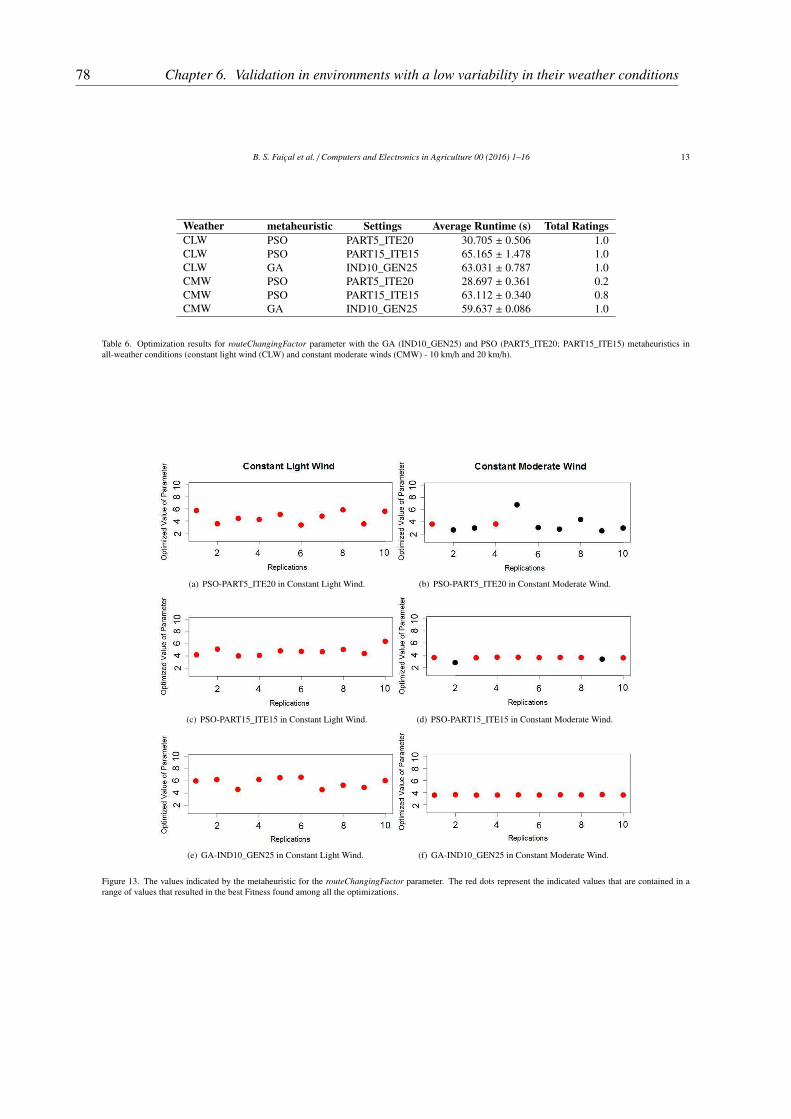
B. S. Faiçal et al. / Computers and Electronics in Agriculture 00 (2016) 1–16 13
Weather metaheuristic Settings Average Runtime (s) Total Ratings
CLW PSO PART5_ITE20 30.705 ± 0.506 1.0CLW PSO PART15_ITE15 65.165 ± 1.478 1.0CLW GA IND10_GEN25 63.031 ± 0.787 1.0CMW PSO PART5_ITE20 28.697 ± 0.361 0.2CMW PSO PART15_ITE15 63.112 ± 0.340 0.8CMW GA IND10_GEN25 59.637 ± 0.086 1.0
Table 6. Optimization results for routeChangingFactor parameter with the GA (IND10_GEN25) and PSO (PART5_ITE20; PART15_ITE15) metaheuristics inall-weather conditions (constant light wind (CLW) and constant moderate winds (CMW) - 10 km/h and 20 km/h).
(a) PSO-PART5_ITE20 in Constant Light Wind. (b) PSO-PART5_ITE20 in Constant Moderate Wind.
(c) PSO-PART15_ITE15 in Constant Light Wind. (d) PSO-PART15_ITE15 in Constant Moderate Wind.
(e) GA-IND10_GEN25 in Constant Light Wind. (f) GA-IND10_GEN25 in Constant Moderate Wind.
Figure 13. The values indicated by the metaheuristic for the routeChangingFactor parameter. The red dots represent the indicated values that are contained in arange of values that resulted in the best Fitness found among all the optimizations.
78 Chapter 6. Validation in environments with a low variability in their weather conditions

B. S. Faiçal et al. / Computers and Electronics in Agriculture 00 (2016) 1–16 14
CWL environment, between the 3.343 and 6.616. On the otherhand, Figures 13(b), 13(d) and 13(f) suggest that, for the CMWweather condition, the search space is less complex, as indi-cated by the smaller range of values, between .561 and 3.660and the best accuracy value found in the experiments. GA-IND10_GEN25 was the only metaheuristic able to keep theconvergence rate at 100% for the range of values that providedthe best adjustment for the route correction.
5.3.2. Evaluation of Pesticide Spraying Accuracy
The proposed system was validated by evaluating the accu-racy of pesticide spraying when the routeChangingFactor pa-rameter is adapted to weather conditions. A simulated assess-ment was carried out to preserve the integrity of the equip-ment and comply with the first validation of the proposal. Thisapproach is commonly used in robotics, where the first vali-dation is carried out using simulation to identify and resolvepotential problems before being actually implemented and de-ployed in the field (Bergamini et al., 2009, Colesanti et al.,2007, Malekzadeh et al., 2011).
The simulation performed produced an deposition matrix asthe result of the pulverization process. The deposition is mea-sured by the amount of particles and the proximity to the targetregion (Faiçal et al., 2014b), which enables the evaluation ofthe spraying. It is important to observe that the experiments areperformed with stochastic variables to approach a realistic ac-tual behavior. These variables are not used for the parameteroptimization phase (making it a deterministic environment), tomake the comparison between the different intensities as fair aspossible (since they are evaluated with the same environment).
As previously described, after the adaptation of routeChang-
ingFactor parameter, the UAV sprays one target sub-area withroute correction. The purpose of this experiment is to eval-uate the spraying accuracy using the intensities indicated byeach metaheuristic (PSO-PART5_ITE20; PSO-PART15_ITE15and GA-IND10_GEN25). To have more robust results, 70 rep-etitions were performed for the worst intensity indicated byeach metaheuristic. The experiments use different stochasticThe metahueristics presented a similar behavior for the CLWweather conditions.
Figure 14 shows the percentage of pesticides deposited inthe target sub-area (when sprayed correctly) for different ap-proaches investigated in the literature and in this paper.. Itshows the increase in the accuracy of the pesticide sprayingobtained by the proposed approach, when compared with theother approaches from the literature. The results from the PSO-PART15_ITE15 metaheuristic presented more compact quar-tiles and with a higher median, when compared with the previ-ously proposed PSO-PART5_ITE20. They also show a spray-ing accuracy improvement when PSO as configured by GridSearch. Finally, GA-IND10_GEN25 presented a spraying ac-curacy higher to the other metaheuristics. The authors believethat the best results were obtained due to the stability in theConvergence rate, despite the complexity of the weather condi-tions investigated.
Statistical tests were conducted to evaluate the obtained re-sults. Initially, the Shapiro-Wilk method was used to verify the
adequacy of the sample sets and normal distribution and, hence,to define if parametric or non-parametric methods should beused. The sample sets resulted in a p-value smaller than 0.05.Thus, the normal distribution hypothesis was rejected and theWilcoxon method was used for the statistical analysis. There-fore, paired comparisons using the Wilcoxon rank sum test (seeTable 7) were made to check whether there is a statistically sig-nificant difference between the sample sets. Despite the appar-ent improvement in accuracy when using the PSO-PART15_-ITE15 rather than PSO-PART5_ITE20, it is not possible to as-sume that there is a statistically significant difference betweenthe results obtained. On the other hand, the Wilcoxon test indi-cates that the accuracy in the spray provided by GA-IND10_-GEN25 is better, with statistical significance, than the othermetaheuristics evaluated (PSO in both settings).
According to the experimental results, GA-IND10_GEN25seems to be a better caption for the AdEn system. This meta-heuristic allowed high-precision spraying in a more complexenvironment for adaptation of the route correction system. Fur-thermore, the routeChangingFactor parameter optimization pro-cess was more stable with the use of the GA-IND10_GEN25than with any of the other metaheuristic analyzed.
6. Conclusion and Future Work
This paper proposes AdE, a system that can adapted theroute correction rules of a UAV pesticide spray in different weatherconditions. This system consists of two elements: (i) CollAct,which is responsible for checking the weather of the crop fieldand updating the routeChangingFactor parameter defined in theUAV’s control system; and (ii) OPTIC, responsible for optimiz-ing the routeChangingFactor parameter to adjust the intensityof the route correction according to the sensored weather con-ditions.
During the AdEn system design, the importance of an ef-ficient optimization optimization process was observed Thus,when validating the proposal and evaluating the progress made,four metaheuristics were assessed as components of the AdEnsystem. The accuracy of the pesticide spray provided by thevalues optimized with these metaheuristics was evaluated.
The results of the experiments demonstrated that the pro-posed AdEn system presented a good performance in the testedscenario, since it uses the control station to process most ofthe workload. Furthermore, the proposed metaheuristic, GA-IND10_GEN25 (set by the Grid Search technique), was shownto be more efficient and stable than other solutions found in theliterature.
In addition to the good results and progress achieved inthis work, it opened up several opportunities for further studies,such as: (i) the development of a computer model for pesticidespraying with lower computational costs; (ii) the optimizationof other parameters (e.g. height and speed of the UAVs) to re-duce errors in pesticide deposition; (iii) investigation of specificcharacteristics of optimization techniques for dynamic environ-ments (Alba et al., 2013, Yang and Yao, 2013); (iv) an investiga-tion of the scalability of the proposed system for implementinga fully-featured prototype model; (v) study on the suitability of
79
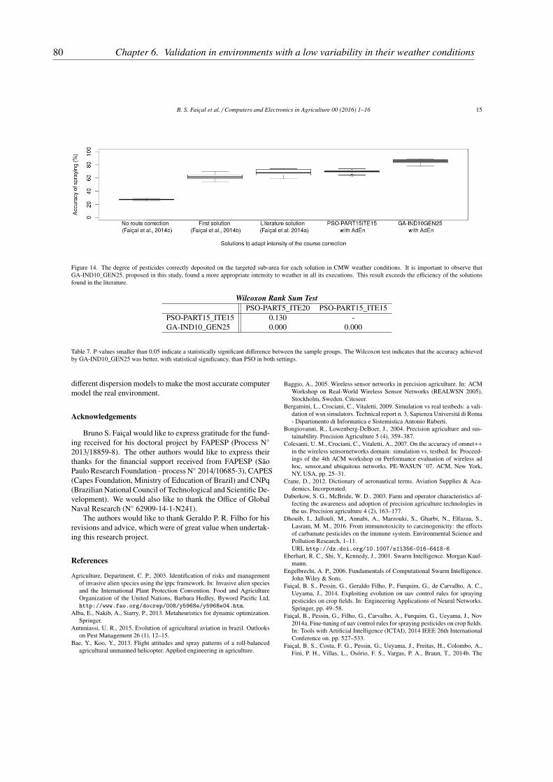
B. S. Faiçal et al. / Computers and Electronics in Agriculture 00 (2016) 1–16 15
Figure 14. The degree of pesticides correctly deposited on the targeted sub-area for each solution in CMW weather conditions. It is important to observe thatGA-IND10_GEN25, proposed in this study, found a more appropriate intensity to weather in all its executions. This result exceeds the efficiency of the solutionsfound in the literature.
Wilcoxon Rank Sum Test
PSO-PART5_ITE20 PSO-PART15_ITE15PSO-PART15_ITE15 0.130 -GA-IND10_GEN25 0.000 0.000
Table 7. P-values smaller than 0.05 indicate a statistically significant difference between the sample groups. The Wilcoxon test indicates that the accuracy achievedby GA-IND10_GEN25 was better, with statistical significancy, than PSO in both settings.
different dispersion models to make the most accurate computermodel the real environment.
Acknowledgements
Bruno S. Faiçal would like to express gratitude for the fund-ing received for his doctoral project by FAPESP (Process N◦
2013/18859-8). The other authors would like to express theirthanks for the financial support received from FAPESP (SãoPaulo Research Foundation - process N◦ 2014/10685-3), CAPES(Capes Foundation, Ministry of Education of Brazil) and CNPq(Brazilian National Council of Technological and Scientific De-velopment). We would also like to thank the Office of GlobalNaval Research (N◦ 62909-14-1-N241).
The authors would like to thank Geraldo P. R. Filho for hisrevisions and advice, which were of great value when undertak-ing this research project.
References
Agriculture, Department, C. P., 2003. Identification of risks and managementof invasive alien species using the ippc framework. In: Invasive alien speciesand the International Plant Protection Convention. Food and AgricultureOrganization of the United Nations, Barbara Hedley, Byword Pacific Ltd,http://www.fao.org/docrep/008/y5968e/y5968e04.htm.
Alba, E., Nakib, A., Siarry, P., 2013. Metaheuristics for dynamic optimization.Springer.
Antuniassi, U. R., 2015. Evolution of agricultural aviation in brazil. Outlookson Pest Management 26 (1), 12–15.
Bae, Y., Koo, Y., 2013. Flight attitudes and spray patterns of a roll-balancedagricultural unmanned helicopter. Applied engineering in agriculture.
Baggio, A., 2005. Wireless sensor networks in precision agriculture. In: ACMWorkshop on Real-World Wireless Sensor Networks (REALWSN 2005),Stockholm, Sweden. Citeseer.
Bergamini, L., Crociani, C., Vitaletti, 2009. Simulation vs real testbeds: a vali-dation of wsn simulators. Technical report n. 3, Sapienza Universitá di Roma- Dipartimento di Informatica e Sistemistica Antonio Ruberti.
Bongiovanni, R., Lowenberg-DeBoer, J., 2004. Precision agriculture and sus-tainability. Precision Agriculture 5 (4), 359–387.
Colesanti, U. M., Crociani, C., Vitaletti, A., 2007. On the accuracy of omnet++in the wireless sensornetworks domain: simulation vs. testbed. In: Proceed-ings of the 4th ACM workshop on Performance evaluation of wireless adhoc, sensor,and ubiquitous networks. PE-WASUN ’07. ACM, New York,NY, USA, pp. 25–31.
Crane, D., 2012. Dictionary of aeronautical terms. Aviation Supplies & Aca-demics, Incorporated.
Daberkow, S. G., McBride, W. D., 2003. Farm and operator characteristics af-fecting the awareness and adoption of precision agriculture technologies inthe us. Precision agriculture 4 (2), 163–177.
Dhouib, I., Jallouli, M., Annabi, A., Marzouki, S., Gharbi, N., Elfazaa, S.,Lasram, M. M., 2016. From immunotoxicity to carcinogenicity: the effectsof carbamate pesticides on the immune system. Environmental Science andPollution Research, 1–11.URL http://dx.doi.org/10.1007/s11356-016-6418-6
Eberhart, R. C., Shi, Y., Kennedy, J., 2001. Swarm Intelligence. Morgan Kauf-mann.
Engelbrecht, A. P., 2006. Fundamentals of Computational Swarm Intelligence.John Wiley & Sons.
Faiçal, B. S., Pessin, G., Geraldo Filho, P., Furquim, G., de Carvalho, A. C.,Ueyama, J., 2014. Exploiting evolution on uav control rules for sprayingpesticides on crop fields. In: Engineering Applications of Neural Networks.Springer, pp. 49–58.
Faiçal, B., Pessin, G., Filho, G., Carvalho, A., Furquim, G., Ueyama, J., Nov2014a. Fine-tuning of uav control rules for spraying pesticides on crop fields.In: Tools with Artificial Intelligence (ICTAI), 2014 IEEE 26th InternationalConference on. pp. 527–533.
Faiçal, B. S., Costa, F. G., Pessin, G., Ueyama, J., Freitas, H., Colombo, A.,Fini, P. H., Villas, L., Osório, F. S., Vargas, P. A., Braun, T., 2014b. The
80 Chapter 6. Validation in environments with a low variability in their weather conditions

B. S. Faiçal et al. / Computers and Electronics in Agriculture 00 (2016) 1–16 16
use of unmanned aerial vehicles and wireless sensor networks for sprayingpesticides. Journal of Systems Architecture 60 (4), 393 – 404.URL http://www.sciencedirect.com/science/article
/pii/S1383762114000204
Faustino, R., Lima, E. M., Simison, W. B., Drewes, R., 2015. Reassessing theconservation status of the shrew crocidura thomensis, endemic to são toméisland.
Forrest, S., Mitchell, M., 1993. Relative building-block fitness and the building-block hypothesis.
Hanson, B., 2008. Investigation of a non-uniform helicopter rotor downwashmodel.
Holland John, H., 1975. Adaptation in natural and artificial systems: an intro-ductory analysis with applications to biology, control, and artificial intelli-gence. USA: University of Michigan.
Huang, Y., Hoffmann, W. C., Lan, Y., Wu, W., Fritz, B. K., 2009. Develop-ment of a spray system for an unmanned aerial vehicle platform. AppliedEngineering in Agriculture 25(6), 803–809.
Kirkpatrick, S., Vecchi, M., et al., 1983. Optimization by simmulated anneal-ing. science 220 (4598), 671–680.
Klaus Wehrle, Mesut Günes, J. G., 2005. Modeling and Tools for NetworkSimulation. Springer.
Köpke, A., Swigulski, M., Wessel, K., Willkomm, D., Haneveld, P. T. K.,Parker, T. E. V., Visser, O. W., Lichte, H. S., Valentin, S., 2008. Simulatingwireless and mobile networks in omnet++ the mixim vision. In: Proceed-ings of the 1st international conference on Simulation tools and techniquesfor communications, networks and systems & workshops. Simutools ’08. In-stitute for Computer Sciences, Social-Informatics and TelecommunicationsEngineering, pp. 71:1–71:8.
Malekzadeh, M., Ghani, A. A. A., Subramaniam, S., Desa, J., May 2011. Val-idating reliability of omnet++ in wireless networks dos attacks: Simulationvs. testbed. International Journal of Network Security 12 (3), 193–201.
McBratney, A., Whelan, B., Ancev, T., Bouma, J., 2005. Future directions ofprecision agriculture. Precision Agriculture 6 (1), 7–23.
Muhlenbein, H., 1991. Evolution in time and space-the parallel genetic algo-rithm. In: Foundations of genetic algorithms. Citeseer.
Nádasi, P., Szabó, I., 2011. On-board applicability of mems-based autonomousnavigation system on agricultural aircrafts. Hungarian Journal of Industryand Chemistry 39 (2), 229–232.
Ozeki, Y., 2011. Aspectos técnicos da pulverização aérea. Tech. rep., Centro deCitricultura.
Pérez-Ruiz, M., Gonzalez-de Santos, P., Ribeiro, A., Fernandez-Quintanilla,C., Peruzzi, A., Vieri, M., Tomic, S., Agüera, J., 2015. Highlights and pre-liminary results for autonomous crop protection. Computers and Electronicsin Agriculture 110, 150–161.
Pimentel, D., 1995. Amounts of pesticides reaching target pests: Environmentalimpacts and ethics. Journal of Agricultural and Environmental Ethics 8 (1),17–29.URL http://dx.doi.org/10.1007/BF02286399
Pimentel, D., 2009. Integrated Pest Management: Innovation-DevelopmentProcess: Volume 1. Springer Netherlands, Dordrecht, Ch. Pesticides andPest Control, pp. 83–87.URL http://dx.doi.org/10.1007/978-1-4020-8992-3_3
Salvador, J. F., 2011. Análise da deposição em aplicações aéreas de defensivosem função de diferentes alturas de vôo e volumes de calda.
Sammons, P. J., Furukawa, T., Bulgin, A., 2005. Autonomous pesticide spray-ing robot for use in a greenhouse. In: Australian Conference on Roboticsand Automation. pp. 1–9.
Tsimbiri, P. F., Moturi, W. N., Sawe, J., Henley, P., Bend, J. R., 2015. Health im-pact of pesticides on residents and horticultural workers in the lake naivasharegion, kenya. Occupational Diseases and Environmental Medicine 3 (02),24.
Valente, J., Sanz, D., Barrientos, A., Cerro, J., Ribeiro, A., Rossi, C., 2011.An air-ground wireless sensor network for crop monitoring. Sensors 11(6),6088–6108.
Varga, A., 2010. Omnet++. In: Wehrle, K., Günes, M., Gross, J. (Eds.), Mod-eling and Tools for Network Simulation. Springer Berlin Heidelberg, pp.35–59.
Vujovic, V., Maksimovic, M., May 2014. Raspberry pi as a wireless sensornode: Performances and constraints. In: Information and CommunicationTechnology, Electronics and Microelectronics (MIPRO), 2014 37th Interna-tional Convention on. pp. 1013–1018.
Walander, P., 2015. Local stakeholders’ willingness to conduct actions enhanc-ing a local population of grey partridge on gotland–an exploratory interviewstudy.
Yang, S., Yao, X., 2013. Evolutionary Computation for Dynamic OptimizationProblems. Springer.
Zhang, C., Kovacs, J. M., 2012. The application of small unmanned aerial sys-tems for precision agriculture: a review. Precision agriculture 13 (6), 693–712.
Zhang, N., Wang, M., Wang, N., 2002. Precision agriculture—a worldwideoverview. Computers and electronics in agriculture 36 (2), 113–132.
81


83
CHAPTER
7
AN INVESTIGATION OF HOW TO ADAPT
THE SPRAY ELEMENT TO ENVIRONMENTS
WITH A HIGH VARIABILITY IN THEIR
WEATHER CONDITIONS
International Journal on Artificial Intelligence Tools
Vol. 25, No. 1 (2016) 1660003 (19 pages)c© World Scientific Publishing Company
DOI: 10.1142/S0218213016600034
Fine-Tuning of UAV Control Rules for Spraying Pesticides on Crop
Fields: An Approach for Dynamic Environments
Bruno S. Faical∗, Gustavo Pessin†, Geraldo P. R. Filho∗,
Andre C. P. L. F. Carvalho∗, Pedro H. Gomes‡ and Jo Ueyama∗
∗University of Sao Paulo (USP), Sao Carlos, SP, Brazil†Applied Computing Lab, Vale Institute of Technology, Belem, PA, Brazil
‡Autonomous Network Research Group (ANRG)University of Southern California, Los Angeles, CA, USA
{bsfaical, geraldop, andre, joueyama}@icmc.usp.br†[email protected]
Received 27 April 2015
Accepted 21 December 2015
Published 23 February 2016
Brazil is an agricultural nation whose process of spraying pesticides is mainly carried out
by using aircrafts. However, the use of aircrafts with on-board pilots has often resultedin chemicals being sprayed outside the intended areas. The precision required for spray-
ing on crop fields is often impaired by external factors, like changes in wind speed and
direction. To address this problem, ensuring that the pesticides are sprayed accurately,this paper proposes the use of artificial neural networks (ANN) on programmable UAVs.
For such, the UAV is programmed to spray chemicals on the target crop field consideringdynamic context. To control the UAV flight route planning, we investigated several opti-
mization techniques including Particle Swarm Optimization (PSO). We employ PSO to
find near-optimal parameters for static environments and then train a neural network tointerpolate PSO solutions in order to improve the UAV route in dynamic environments.
Experimental results showed a gain in the spraying precision in dynamic environments
when ANN and PSO were combined. We demonstrate the improvement in figures whencompared against the exclusive use of PSO. This approach will be embedded in UAVs
with programmable boards, such as Raspberry PIs or Beaglebones. The experimental
results demonstrate that the proposed approach is feasible and can meet the demandfor a fast response time needed by the UAV to adjust its route in a highly dynamic
environment, while seeking to spray pesticides accurately.
Keywords: Unmanned aerial vehicle; agricultural applications; dynamic environments;neural networks; evolutionary algorithms.
1. Introduction
Pesticides, also known as agrochemicals, are generally applied in agricultural
crop fields to increase productivity, improve quality and reduce production costs.
1660003-1
Int.
J.
Art
if.
Inte
ll.
To
ols
20
16
.25
. D
ow
nlo
aded
fro
m w
ww
.wo
rld
scie
nti
fic.
com
by
UN
IVE
RS
ITY
OF
SA
O P
AU
LO
on
04
/06
/16
. F
or
per
son
al u
se o
nly
.84Chapter 7. An investigation of how to adapt the spray element to environments with a high variability in
their weather conditions

B. S. Faical et al.
However, prolonged contact (either directly or indirectly) with these products can
cause various diseases to humans, such as several types of cancers, complications
to the respiratory system and neurological diseases.1 It is estimated that about
2.5 million tons of pesticides are used each year throughout the world and this
amount is growing.2 Much of the pesticide is wasted during the spraying process
due to the type of technology employed. Evidence show that the drift of pesticides
is generally found at a distance of 48 m to 800 m from the target crop field; the
deviation can range from a distance of 5 km to 32 km downwind.3
The use of unmanned aerial vehicles (UAV) to carry out the task of spraying
pesticides can have several benefits, including (i) to reduce human contact with the
chemicals, which helps to preserve human health; and (ii) to improve the perfor-
mance of the spraying operation, by avoiding the presence of chemicals outside the
designated areas, which is important to protect the neighboring fields that may have
other crops, and protect nature reserves or water sources. The sets of control rules
to be employed in an autonomous UAV are very hard to put into effect and even
harder to fine-tune to each environmental feature. Due to the technical features of
each UAV, a fine-tuning phase must include the parameters of the algorithm. This
process must also take into account the type of crop being handled and the type of
pesticide being used.
The proposed architecture employs an UAV that has an attached spraying sys-
tem and is able to communicate with a wireless sensor network (WSN), which is
arranged in a matrix-like grid on the crop field. The WSN sends feedback on the
weather conditions and determines how the pesticide is actually being applied on the
target crop field. On the basis of the received information, the UAV appropriately
adopts a policy that allows it to correct its route. Hence, the main contributions
of this research are: (i) to investigate an evolutionary methodology capable of min-
imizing human contact with pesticides, (ii) to evaluate an evolutionary approach
that is able to reduce errors when spraying pesticides in areas where vegetables and
fruits are grown, (iii) to investigate techniques able to maximize quality in agricul-
tural production, and (iv) to increase the autonomy of the architecture proposed
by Faical et al.,4 in which the policy parameters were set out empirically and could
be applied regardless of the weather conditions.
This paper extends the previous work5 by presenting a proposal and an eval-
uation on how UAVs can be controlled in a highly dynamic environment, such
as environments with sudden changes in the speed and direction of the wind. To
this aim, we devised an ANN to be employed in real-world operations, which was
built with evolved values employing a PSO approach. We employ the PSO to find
near-optimal parameters for static environments and then train a neural network to
interpolate the PSO solutions in order to improve the UAV route in dynamic envi-
ronments. Neural networks have an intrinsic mapping and generalization features,
which make them a good choice for dynamic environments,6,7 while the evolution-
ary approach is a good mean to discovering non-trivial parameters.8,9 Combining
1660003-2
Int.
J.
Art
if.
Inte
ll.
To
ols
20
16
.25
. D
ow
nlo
aded
fro
m w
ww
.wo
rld
scie
nti
fic.
com
by
UN
IVE
RS
ITY
OF
SA
O P
AU
LO
on
04
/06
/16
. F
or
per
son
al u
se o
nly
.
85
Fine-Tuning of UAV Control Rules
the evolutionary technique with the neural approach in this work allowed us to
leverage the best capabilities of each technique. In such a way, we propose the use
of an ANN for quick decision-making, since in real environments the weather con-
ditions change suddenly and at short intervals of time. The new proposal provides
a significant advance in the optimization of an UAV route which can be used in real
environments, as a trained ANN is faster than running the evolutionary process of
PSO technique over and over again whenever the weather conditions are change-
able. Moreover, even if the employed hardware has enough resources to perform the
technique PSO quickly, the ANN will enable the intensity of the route adjustment
to be adjusted in a shorter time.
This paper is divided into six sections. Section 2 examines other studies related
to this paper. Following this, Section 3 provides an outline of the architecture to
clarify the scope of this paper and the optimization methodology proposed in this
work. The experiments and results are analyzed and discussed in Section 4, and then
compared with the results found in the literature. Finally, Section 5 summarizes the
conclusions obtained from the results and suggests how this paper might encourage
further studies in this field.
2. Related Work
There are several studies that suggest how UAVs or WSNs can be employed for mon-
itoring agricultural production, occasionally by integrating both technologies.10–12
However, this work differs in so far as it proposes a particle swarm optimization
algorithm to optimize the control rules of the UAV at runtime, based on feedback
provided by WSN about weather conditions in the agricultural field.
Valente et al.13 describe a WSN-based system and UAV to monitor vineyards.
The WSNs collect information about weather, soil and planting conditions and then
make it available to farmers. However, a field crop may be hundreds of meters away
from other fields and sometimes there are barriers (e.g. rivers and roads) that sep-
arate two crop fields. Thus, it may not be feasible or cost-effective to use cables to
connect the WSN. Although the use of powerful wireless devices allows communica-
tion between WSNs, this solution leads to higher energy consumption and involves
reducing the lifetime of the nodes. One solution that can be adopted to overcome
these limitations is the employment a UAV to fly over the crop fields and gather
information from each WSN, which can then be conveyed to a processing center.
Although this study demonstrates that UAVs and WSNs can be integrated to pro-
vide efficient solutions or improvements in an agricultural setting, no methodology
is employed for optimization at runtime. Additionally, a UAV is used as a mobile
node in a WSN without having any adverse effects on the environment.
Huang et al.14 devise a particular system for spraying pesticide. This system
should be coupled with a UAV that is capable of carrying approximately 22.7 kg.
The model used in this work is UAV SR200 (manufactured by Rotomotion). The
spraying system consists of four main components: (i) a metal tube with nozzles;
1660003-3
Int.
J.
Art
if.
Inte
ll.
To
ols
20
16
.25
. D
ow
nlo
aded
fro
m w
ww
.wo
rld
scie
nti
fic.
com
by
UN
IVE
RS
ITY
OF
SA
O P
AU
LO
on
04
/06
/16
. F
or
per
son
al u
se o
nly
.86Chapter 7. An investigation of how to adapt the spray element to environments with a high variability in
their weather conditions

B. S. Faical et al.
(ii) a tank to store pesticide; (iii) a pump to move the liquid; and (iv) a mechanism
for controlling the activation of the spray. The spraying system can carry up to
5 kg of pesticide, which is enough to spray 14 ha; and it has a flight time of around
90 min. The main objective of this study is to validate the proposed system and
evaluate different types of spray nozzles. However, the weather conditions were not
taken into account. Additionally, it does not include a discussion of an evolutionary
methodology that is able to optimize control of this activity.
Faical et al.4 proposed an architecture formed of a UAV and WSN to spray
pesticide in crop fields. It is known that adverse weather conditions, such as high-
speed winds, can cause errors in the spraying process. The study shows how the
recommended architecture can reduce the risk of errors and increase control over
this activity. With the aid of feedback from the WSN on pesticide concentrations,
the route is gradually changed until the sensor node can identify the correct appli-
cation of the product. However, the parameters set for the route change are applied
in different weather conditions, which might impair the performance of this archi-
tecture. As mentioned earlier, this paper addresses this limitation by evaluating a
methodology that is employed for the fine-tuning of a parameter that ponders the
changes in the intensity of the route followed by the UAV.
3. Proposed Approach
3.1. UAV and WSN architecture for spraying on crop fields
Figure 1 illustrates how the UAV acts as an agent on the crop fields. The UAV is
equipped with a spraying system and a communication module, which enables data
exchange with a WSN arranged on the crop fields; it flies over the area and sprays
the pesticide in its entire length. The WSN is only depicted within the targeted crop
fields and is bounded by two dark dashed lines (from top left to bottom right) to
simplify the viewing image. At the top of Fig. 1, there are two arrows that indicate
Fig. 1. Example of spraying in crop fields with the architecture proposed by Faical et al.4 This
architecture consists of a UAV (to spray) andWSN (to monitor). If the WSN detects an unbalancedspray on its sensor nodes, the UAV changes its route to correct the spraying of the pesticide.
1660003-4
Int.
J.
Art
if.
Inte
ll.
To
ols
20
16
.25
. D
ow
nlo
aded
fro
m w
ww
.wo
rld
scie
nti
fic.
com
by
UN
IVE
RS
ITY
OF
SA
O P
AU
LO
on
04
/06
/16
. F
or
per
son
al u
se o
nly
.
87

Fine-Tuning of UAV Control Rules
the wind direction at a particular location. Through its communication link with
the WSN, the UAV is able to obtain information about the weather (e.g. speed and
direction of the wind) and the concentration of pesticides sprayed on the crops. If
an imbalance is detected in this concentration (e.g. the sensor on the left identifies a
higher concentration than the sensor on the right), possibly caused by the wind, the
UAV adopts a policy that involves changing its route to balance the application of
pesticides throughout the whole extent of the targeted crop fields. This policy also
helps to prevent overlapping when the chemical is applied. In Fig. 1, the correction
of the route is represented by small arrows between the images of the UAV.
A parameter called routeChangingFactor is employed in the route change func-
tion to set the degree of intensity (e.g. mild or sharp) so that the change can be
made. However, despite the importance of this parameter to ensure the success of
the spraying, its value is set empirically before the beginning of the flight and is
used for all weather conditions that occur during the spraying process. This charac-
teristic can affect the quality of the spraying; for example, a sharp correction might
be made in an environment where a low wind speed has been detected. Moreover,
an increase in the complexity of this environment might cause variable behavior.
In other words, the weather conditions can change during the activity, and this is
detrimental to the whole architecture if it has a static configuration.
The routeChangingFactor parameter is a weighting variable used in the calcula-
tion of the period of time assigned for a UAV route change.4 It defines if the route
change will be of mild intensity (low value, resulting in more time for a change
of route) or high intensity (high value, resulting in a short time to be re-routed).
Equation (1) illustrates the time that the UAV remains in change of route is set.
In this equation, ls (left sensor) and rs (right sensor) are data received from the
pair of sensors deployed inside the plantation and located in the spraying tracks
(see Fig. 1), τ is the routeChangingFactor and ∆ corresponds to the period of time
assigned for the route change.
∆ =|ls− rs|
τ. (1)
This equation is used by the UAV control policy, which sets a minimum threshold
for the difference between the values from the pair of sensor to decide whether the
route change should occur. If the difference is larger than the threshold, the UAV
control policy re-defines the duration of the route change (based on Eq. (1)), the
angle and the direction required for the aircraft.
To overcome the problems previously mentioned, this paper proposes a
methodology based on Particle Swarm Optimization to optimize the parameter
routeChangingFactor. As previously mentioned, the parameter of route change has
a large influence on spraying and, in addition, the architecture is employed in a
dynamic environment. Thus, it is worth investigating a methodology that is able
to find a value for the parameter routeChangingFactor (and is close to an optimal
solution). Figure 2 shows the behavior of the architecture when the optimization
1660003-5
Int.
J.
Art
if.
Inte
ll.
To
ols
20
16
.25
. D
ow
nlo
aded
fro
m w
ww
.wo
rld
scie
nti
fic.
com
by
UN
IVE
RS
ITY
OF
SA
O P
AU
LO
on
04
/06
/16
. F
or
per
son
al u
se o
nly
.88Chapter 7. An investigation of how to adapt the spray element to environments with a high variability in
their weather conditions

B. S. Faical et al.
Fig. 2. Behavior of the architecture that employs the proposed optimization methodology. TheControl Station (A) is installed outside the target crop field, in a zone within communication
range of the UAV (B). During the spraying of the current crop field (D), the UAV sends a request
for weather information about the next crop field (E) to the WSN (C). When the requestedinformation is received, the UAV sends it to Control Station (A) where it will be used by the
optimization methodology. At the end of the optimization, the Control Station sends the newconfiguration back to the UAV. The settings will be updated when the spraying of the current
crop field has been completed and the spraying of the next crop field is about to begin.
methodology is used. It assumes that a crop field is composed of several small
virtual subareas with a rectangular shape. Thus, if all the subareas are sprayed,
this results in a complete spraying of the crop field. Each subarea will be called a
“crop field” during this study. The UAV’s flight plan is designed to ensure that the
next crop field will be sprayed right after the work on the current crop field has
been completed. The route change, as described earlier, is made in the current crop
field (D). Running parallel with this activity, the UAV (B) queries the WSN (C)
about the weather conditions in the next crop field (E). At this stage the request
can reach the nodes that are deployed inside the next crop field by using multi-
hop links (not shown in the diagram). Only the endpoints of the communication
(source and destination) are shown for a clear image. As soon as the UAV obtains
weather information, this is sent to Control Station (A) to optimize the parame-
ter routeChangingFactor. At this time, the optimization methodology proposal is
executed on the basis of the weather information. At the end of the optimization,
the best value of the parameter is sent back to the UAV. When the spraying of
the current crop field (D) is finalized, the UAV updates its settings so that the
spraying of the next crop field (E) can start. It should be highlighted that the use
of a Control Station provides more powerful computation and, in addition, allows a
pilot (on the ground) to oversee the flight and, if necessary, intervene in the control
of the UAV.
1660003-6
Int.
J.
Art
if.
Inte
ll.
To
ols
20
16
.25
. D
ow
nlo
aded
fro
m w
ww
.wo
rld
scie
nti
fic.
com
by
UN
IVE
RS
ITY
OF
SA
O P
AU
LO
on
04
/06
/16
. F
or
per
son
al u
se o
nly
.
89
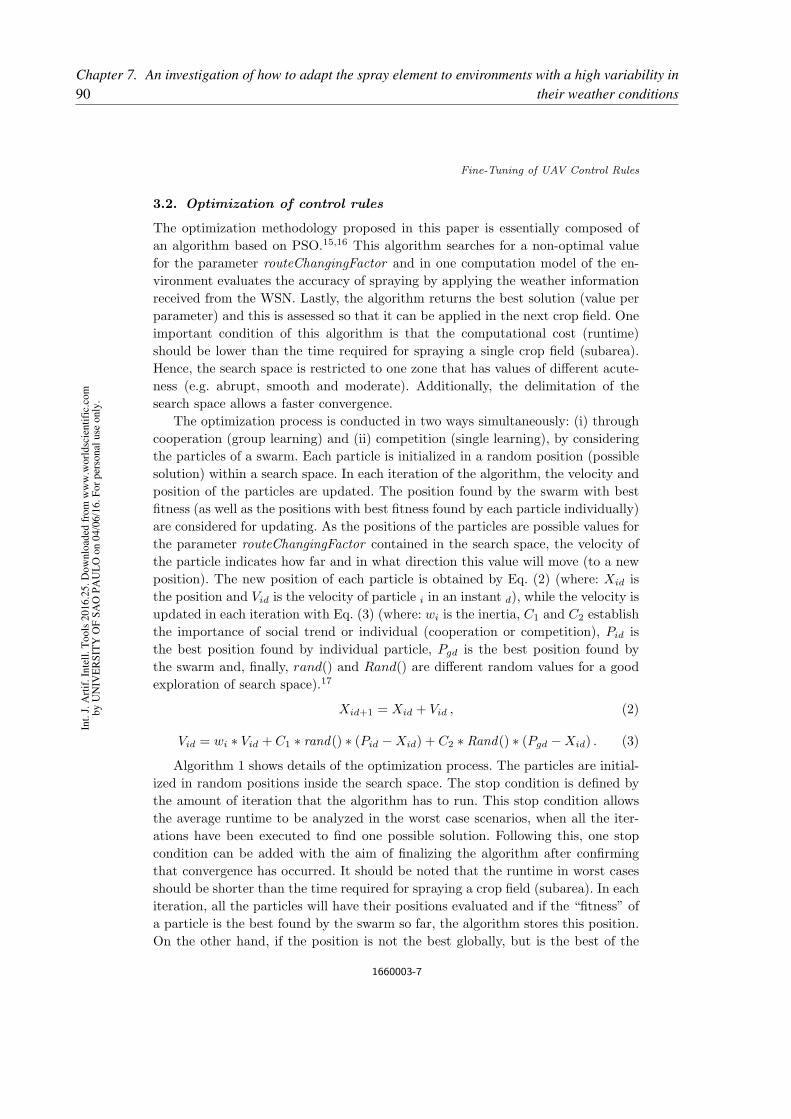
Fine-Tuning of UAV Control Rules
3.2. Optimization of control rules
The optimization methodology proposed in this paper is essentially composed of
an algorithm based on PSO.15,16 This algorithm searches for a non-optimal value
for the parameter routeChangingFactor and in one computation model of the en-
vironment evaluates the accuracy of spraying by applying the weather information
received from the WSN. Lastly, the algorithm returns the best solution (value per
parameter) and this is assessed so that it can be applied in the next crop field. One
important condition of this algorithm is that the computational cost (runtime)
should be lower than the time required for spraying a single crop field (subarea).
Hence, the search space is restricted to one zone that has values of different acute-
ness (e.g. abrupt, smooth and moderate). Additionally, the delimitation of the
search space allows a faster convergence.
The optimization process is conducted in two ways simultaneously: (i) through
cooperation (group learning) and (ii) competition (single learning), by considering
the particles of a swarm. Each particle is initialized in a random position (possible
solution) within a search space. In each iteration of the algorithm, the velocity and
position of the particles are updated. The position found by the swarm with best
fitness (as well as the positions with best fitness found by each particle individually)
are considered for updating. As the positions of the particles are possible values for
the parameter routeChangingFactor contained in the search space, the velocity of
the particle indicates how far and in what direction this value will move (to a new
position). The new position of each particle is obtained by Eq. (2) (where: Xid is
the position and Vid is the velocity of particle i in an instant d), while the velocity is
updated in each iteration with Eq. (3) (where: wi is the inertia, C1 and C2 establish
the importance of social trend or individual (cooperation or competition), Pid is
the best position found by individual particle, Pgd is the best position found by
the swarm and, finally, rand() and Rand() are different random values for a good
exploration of search space).17
Xid+1 = Xid + Vid , (2)
Vid = wi ∗ Vid + C1 ∗ rand() ∗ (Pid −Xid) + C2 ∗ Rand() ∗ (Pgd −Xid) . (3)
Algorithm 1 shows details of the optimization process. The particles are initial-
ized in random positions inside the search space. The stop condition is defined by
the amount of iteration that the algorithm has to run. This stop condition allows
the average runtime to be analyzed in the worst case scenarios, when all the iter-
ations have been executed to find one possible solution. Following this, one stop
condition can be added with the aim of finalizing the algorithm after confirming
that convergence has occurred. It should be noted that the runtime in worst cases
should be shorter than the time required for spraying a crop field (subarea). In each
iteration, all the particles will have their positions evaluated and if the “fitness” of
a particle is the best found by the swarm so far, the algorithm stores this position.
On the other hand, if the position is not the best globally, but is the best of the
1660003-7
Int.
J.
Art
if.
Inte
ll.
To
ols
20
16
.25
. D
ow
nlo
aded
fro
m w
ww
.wo
rld
scie
nti
fic.
com
by
UN
IVE
RS
ITY
OF
SA
O P
AU
LO
on
04
/06
/16
. F
or
per
son
al u
se o
nly
.90Chapter 7. An investigation of how to adapt the spray element to environments with a high variability in
their weather conditions

B. S. Faical et al.
Algorithm 1: Proposed algorithm to optimize the routeChangingFactor
parameter.
1: InitializeParticles(RandomPosition[1, 10])
2: for MAX ITERATION do
3: PARTICLES ← FirstParticle()
4: for ALL PARTICLES do
5: Result← FuncObjetive(PARTICLES)
6: if Result is best particle then
7: Stores the position in particle
8: end if
9: if Result is the best in the swarm then
10: Stores the position in swarm
11: end if
12: UpdateV elocity(PARTICLES)
13: NewPosition(PARTICLES)
14: PARTICLES ← NextParticle()
15: end for
16: end for
17: return BestGlobalPosition
particle, the algorithm also stores this position in the particle. Later on, the ve-
locity and the position of each particle are updated. When the algorithm achieves
maximum interaction, it is finalized and the best position found by the swarm is
returned.
The objective function (FuncObjetive) contained in the Algorithm, cited in
Line 5 of Algorithm 1, refers to an interaction with one project inside the
OMNeT++ software. The project is an implementation of a computational model
to evaluate the spraying.4 This interaction tests and analyzes the quality of spray-
ing in each position of all the particles. The OMNeT++a is a simulator of discrete
events based on C++ language to model networks, multiprocessors and other dis-
tributed and parallel systems.18 The OMNeT++ can be used to model several types
of networks, such as networks of queues, wireless and peer-to-peer types.19 Because
of its generic design, OMNeT++ has several frameworks established for specific
networks, such as Miximb for modeling wireless networks. This framework provides
detailed models for wireless channels, wireless connections, mobility models, mod-
els for dealing with obstacles and several communication protocols, especially for
MAC.20 Figure 3 shows the connection between the algorithm and OMNeT++.
aOMNeT++ Network Simulation Framework, http://www.omnetpp.orgbMiXiM project, http://mixim.sourceforge.net
1660003-8
Int.
J.
Art
if.
Inte
ll.
To
ols
20
16
.25
. D
ow
nlo
aded
fro
m w
ww
.wo
rld
scie
nti
fic.
com
by
UN
IVE
RS
ITY
OF
SA
O P
AU
LO
on
04
/06
/16
. F
or
per
son
al u
se o
nly
.
91
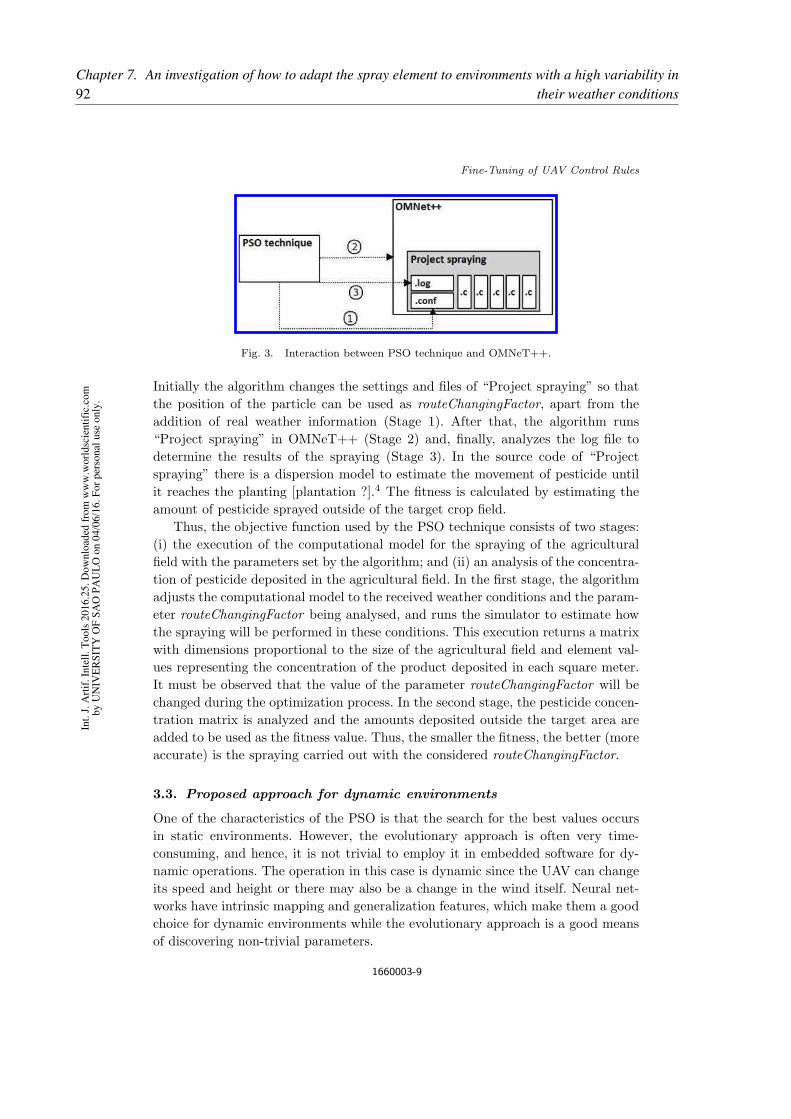
Fine-Tuning of UAV Control Rules
Fig. 3. Interaction between PSO technique and OMNeT++.
Initially the algorithm changes the settings and files of “Project spraying” so that
the position of the particle can be used as routeChangingFactor, apart from the
addition of real weather information (Stage 1). After that, the algorithm runs
“Project spraying” in OMNeT++ (Stage 2) and, finally, analyzes the log file to
determine the results of the spraying (Stage 3). In the source code of “Project
spraying” there is a dispersion model to estimate the movement of pesticide until
it reaches the planting [plantation ?].4 The fitness is calculated by estimating the
amount of pesticide sprayed outside of the target crop field.
Thus, the objective function used by the PSO technique consists of two stages:
(i) the execution of the computational model for the spraying of the agricultural
field with the parameters set by the algorithm; and (ii) an analysis of the concentra-
tion of pesticide deposited in the agricultural field. In the first stage, the algorithm
adjusts the computational model to the received weather conditions and the param-
eter routeChangingFactor being analysed, and runs the simulator to estimate how
the spraying will be performed in these conditions. This execution returns a matrix
with dimensions proportional to the size of the agricultural field and element val-
ues representing the concentration of the product deposited in each square meter.
It must be observed that the value of the parameter routeChangingFactor will be
changed during the optimization process. In the second stage, the pesticide concen-
tration matrix is analyzed and the amounts deposited outside the target area are
added to be used as the fitness value. Thus, the smaller the fitness, the better (more
accurate) is the spraying carried out with the considered routeChangingFactor.
3.3. Proposed approach for dynamic environments
One of the characteristics of the PSO is that the search for the best values occurs
in static environments. However, the evolutionary approach is often very time-
consuming, and hence, it is not trivial to employ it in embedded software for dy-
namic operations. The operation in this case is dynamic since the UAV can change
its speed and height or there may also be a change in the wind itself. Neural net-
works have intrinsic mapping and generalization features, which make them a good
choice for dynamic environments while the evolutionary approach is a good means
of discovering non-trivial parameters.
1660003-9
Int.
J.
Art
if.
Inte
ll.
To
ols
20
16
.25
. D
ow
nlo
aded
fro
m w
ww
.wo
rld
scie
nti
fic.
com
by
UN
IVE
RS
ITY
OF
SA
O P
AU
LO
on
04
/06
/16
. F
or
per
son
al u
se o
nly
.92Chapter 7. An investigation of how to adapt the spray element to environments with a high variability in
their weather conditions
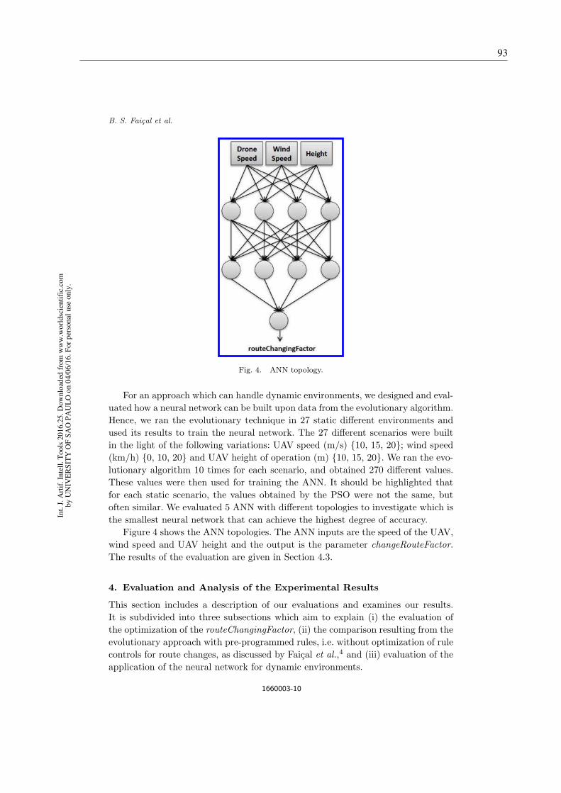
B. S. Faical et al.
Fig. 4. ANN topology.
For an approach which can handle dynamic environments, we designed and eval-
uated how a neural network can be built upon data from the evolutionary algorithm.
Hence, we ran the evolutionary technique in 27 static different environments and
used its results to train the neural network. The 27 different scenarios were built
in the light of the following variations: UAV speed (m/s) {10, 15, 20}; wind speed
(km/h) {0, 10, 20} and UAV height of operation (m) {10, 15, 20}. We ran the evo-
lutionary algorithm 10 times for each scenario, and obtained 270 different values.
These values were then used for training the ANN. It should be highlighted that
for each static scenario, the values obtained by the PSO were not the same, but
often similar. We evaluated 5 ANN with different topologies to investigate which is
the smallest neural network that can achieve the highest degree of accuracy.
Figure 4 shows the ANN topologies. The ANN inputs are the speed of the UAV,
wind speed and UAV height and the output is the parameter changeRouteFactor.
The results of the evaluation are given in Section 4.3.
4. Evaluation and Analysis of the Experimental Results
This section includes a description of our evaluations and examines our results.
It is subdivided into three subsections which aim to explain (i) the evaluation of
the optimization of the routeChangingFactor, (ii) the comparison resulting from the
evolutionary approach with pre-programmed rules, i.e. without optimization of rule
controls for route changes, as discussed by Faical et al.,4 and (iii) evaluation of the
application of the neural network for dynamic environments.
1660003-10
Int.
J.
Art
if.
Inte
ll.
To
ols
20
16
.25
. D
ow
nlo
aded
fro
m w
ww
.wo
rld
scie
nti
fic.
com
by
UN
IVE
RS
ITY
OF
SA
O P
AU
LO
on
04
/06
/16
. F
or
per
son
al u
se o
nly
.
93

Fine-Tuning of UAV Control Rules
Table 1. Results of the optimization of therouteChangingFactor parameter. The first column
shows the set of evaluated PSO as P#I# meaning P
(number of particles) and I (number of interactions).
Convergence Average Time
Settings Rate (%) of Evolutions (s)
P3I20 96.77 18.617± 0.371
P3I50 100.00 45.927± 0.649
P3I100 100.00 93.854± 1.555
P5I20 100.00 30.705± 0.506
P5I50 100.00 77.162± 0.766
P5I100 100.00 158.995± 3.143
P10I20 100.00 62.549± 0.912
P10I50 100.00 157.957± 2.976
P10I100 100.00 313.335± 1.488
P15I20 100.00 93.606± 0.799
P15I50 100.00 235.189± 1.816
P15I100 100.00 480.359± 14.762
P20I20 100.00 125.088± 1.059
P20I50 100.00 312.894± 2.058
P20I100 100.00 628.324± 2.251
4.1. Optimization of the routeChangingFactor parameter
In this stage, the algorithm will search for the best possible value when applying it
as the parameter of route changes (taking into account the feedback obtained from
the weather information). The evaluated settings are called as: P#I#, meaning P
(number of particles) and I (number of interactions). Each configuration is repli-
cated thirty times to obtain a greater confidence level for future statistical analysis.
The algorithm is defined so that it will prefer the social trend (C2 = 0.75) to the
individual trend (C1 = 0.25) in the search. Another important parameter for run-
ning the algorithm is Inertia, which is used to strike a balance between local and
global searches, and is set to carry out local searches (wi = 0.1). This configuration
aims at a “quick pull” of the swarm of particles to a place considered promising
because it contains a better intensity than the others found so far. Moreover, it is
expected that the particles will carry out a thorough search in the region where
they are located. It is notable that both the ability not to remain stuck in local
minima and the convergence of the algorithm were considered in this study, which
showed a satisfactory performance.
Due to the low communication time, measured in Ref. 4, it can be assumed
that the communication time between the UAV and Control Station does not have
a significant influence on the total runtime. Thus, it can be assumed from this
experiment that the weather information is already in the Control Station.
This subsection shows the results when the PSO-based algorithm described in
Section 3.2 is employed. Table 1 shows the results of the first stage. Apart from
1660003-11
Int.
J.
Art
if.
Inte
ll.
To
ols
20
16
.25
. D
ow
nlo
aded
fro
m w
ww
.wo
rld
scie
nti
fic.
com
by
UN
IVE
RS
ITY
OF
SA
O P
AU
LO
on
04
/06
/16
. F
or
per
son
al u
se o
nly
.94Chapter 7. An investigation of how to adapt the spray element to environments with a high variability in
their weather conditions
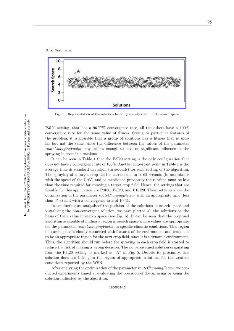
B. S. Faical et al.
Fig. 5. Representation of the solutions found by the algorithm in the search space.
P3I20 setting, that has a 96.77% convergence rate, all the others have a 100%
convergence rate for the same value of fitness. Owing to particular features of
the problem, it is possible that a group of solutions has a fitness that is simi-
lar but not the same, since the difference between the values of the parameter
routeChangingFactor may be low enough to have no significant influence on the
spraying in specific situations.
It can be seen in Table 1 that the P3I20 setting is the only configuration that
does not have a convergence rate of 100%. Another important point in Table 1 is the
average time ± standard deviation (in seconds) for each setting of the algorithm.
The spraying of a target crop field is carried out in ≈ 65 seconds (in accordance
with the speed of the UAV) and as mentioned previously the runtime must be less
than the time required for spraying a target crop field. Hence, the settings that are
feasible for this application are P3I50, P5I20, and P10I20. These settings allow the
optimization of the parameter routeChangingFactor with an appropriate time (less
than 65 s) and with a convergence rate of 100%.
In conducting an analysis of the position of the solutions in search space and
visualizing the non-convergent solution, we have plotted all the solutions on the
basis of their value in search space (see Fig. 5). It can be seen that the proposed
algorithm is capable of finding a region in search space where values are appropriate
for the parameter routeChangingFactor in specific climatic conditions. This region
in search space is closely connected with features of the environment and tends not
to be an appropriate region for the next crop field, since it is a dynamic environment.
Thus, the algorithm should run before the spraying in each crop field is started to
reduce the risk of making a wrong decision. The non-converged solution originating
from the P3I20 setting, is marked as “A” in Fig. 5. Despite its proximity, this
solution does not belong to the region of appropriate solutions for the weather
conditions reported by the WSN.
After analyzing the optimization of the parameter routeChangingFactor, we con-
ducted experiments aimed at evaluating the precision of the spraying by using the
solution indicated by the algorithm.
1660003-12
Int.
J.
Art
if.
Inte
ll.
To
ols
20
16
.25
. D
ow
nlo
aded
fro
m w
ww
.wo
rld
scie
nti
fic.
com
by
UN
IVE
RS
ITY
OF
SA
O P
AU
LO
on
04
/06
/16
. F
or
per
son
al u
se o
nly
.
95
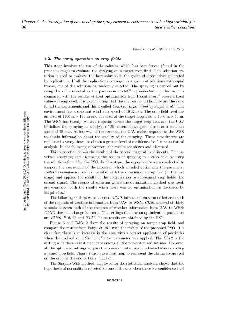
Fine-Tuning of UAV Control Rules
4.2. The spray operation on crop fields
This stage involves the use of the solution which has best fitness (found in the
previous stage) to evaluate the spraying on a target crop field. This selection cri-
terion is used to evaluate the best solution in the group of alternatives generated
by replications. If all the replications converge in a group of solutions with equal
fitness, one of the solutions is randomly selected. The spraying is carried out by
using the value selected as the parameter routeChangingFactor and the result is
compared with the results without optimization from Faical et al.,4 where a fixed
value was employed. It is worth noting that the environmental features are the same
for all the experiments and this is called Constant Light Wind by Faical et al.4 This
environment has a constant wind at a speed of 10 Km/h. The crop field used has
an area of 1100 m× 150 m and the area of the target crop field is 1000 m× 50 m.
The WSN has twenty-two nodes spread across the target crop field and the UAV
initializes the spraying at a height of 20 meters above ground and at a constant
speed of 15 m/s. At intervals of ten seconds, the UAV makes requests to the WSN
to obtain information about the quality of the spraying. These experiments are
replicated seventy times, to obtain a greater level of confidence for future statistical
analysis. In the following subsection, the results are shown and discussed.
This subsection shows the results of the second stage of experiments. This in-
volved analyzing and discussing the results of spraying in a crop field by using
the solutions found by the PSO. In this stage, the experiments were conducted to
support the assessment of the proposal, which entailed optimizing the parameter
routeChangingFactor and ran parallel with the spraying of a crop field (in the first
stage) and applied the results of the optimization to subsequent crop fields (the
second stage). The results of spraying where the optimization method was used,
are compared with the results when there was no optimization as discussed by
Faical et al.4
The following settings were adopted: CL10, interval of ten seconds between each
of the requests of weather information from UAV to WSN; CL30, interval of thirty
seconds between each of the requests of weather information from UAV to WSN;
CLNO does not change its route. The settings that use an optimization parameter
are P5I20, P10I20, and P3I50. These results are obtained by the PSO.
Figure 6 and Table 2 show the results of spraying on target crop field, and
compare the results from Faical et al.4 with the results of the proposed PSO. It is
clear that there is an increase in the area with a correct application of pesticides
when the evolved routeChangingFactor parameter was applied. The CL10 is the
setting with the smallest error rate among all the non-optimized settings. However,
all the optimized settings surpass the precision rate usually achieved when spraying
a target crop field. Figure 7 displays a heat map to represent the chemicals sprayed
on the crop at the end of the simulation.
The Shapiro Wilk method, employed for the statistical analysis, shows that the
hypothesis of normality is rejected for one of the sets when there is a confidence level
1660003-13
Int.
J.
Art
if.
Inte
ll.
To
ols
20
16
.25
. D
ow
nlo
aded
fro
m w
ww
.wo
rld
scie
nti
fic.
com
by
UN
IVE
RS
ITY
OF
SA
O P
AU
LO
on
04
/06
/16
. F
or
per
son
al u
se o
nly
.96Chapter 7. An investigation of how to adapt the spray element to environments with a high variability in
their weather conditions
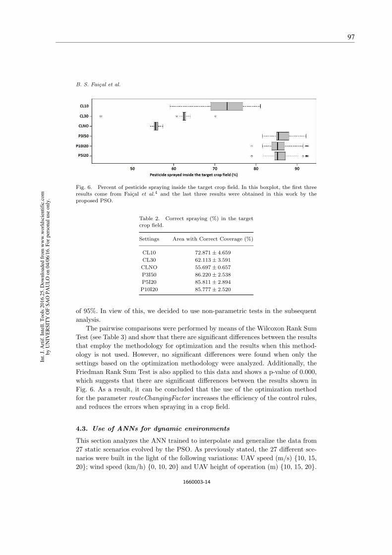
B. S. Faical et al.
Fig. 6. Percent of pesticide spraying inside the target crop field. In this boxplot, the first three
results come from Faical et al.4 and the last three results were obtained in this work by the
proposed PSO.
Table 2. Correct spraying (%) in the targetcrop field.
Settings Area with Correct Coverage (%)
CL10 72.871± 4.659
CL30 62.113± 3.591
CLNO 55.697± 0.657
P3I50 86.220± 2.538
P5I20 85.811± 2.894
P10I20 85.777± 2.520
of 95%. In view of this, we decided to use non-parametric tests in the subsequent
analysis.
The pairwise comparisons were performed by means of the Wilcoxon Rank Sum
Test (see Table 3) and show that there are significant differences between the results
that employ the methodology for optimization and the results when this method-
ology is not used. However, no significant differences were found when only the
settings based on the optimization methodology were analyzed. Additionally, the
Friedman Rank Sum Test is also applied to this data and shows a p-value of 0.000,
which suggests that there are significant differences between the results shown in
Fig. 6. As a result, it can be concluded that the use of the optimization method
for the parameter routeChangingFactor increases the efficiency of the control rules,
and reduces the errors when spraying in a crop field.
4.3. Use of ANNs for dynamic environments
This section analyzes the ANN trained to interpolate and generalize the data from
27 static scenarios evolved by the PSO. As previously stated, the 27 different sce-
narios were built in the light of the following variations: UAV speed (m/s) {10, 15,
20}; wind speed (km/h) {0, 10, 20} and UAV height of operation (m) {10, 15, 20}.
1660003-14
Int.
J.
Art
if.
Inte
ll.
To
ols
20
16
.25
. D
ow
nlo
aded
fro
m w
ww
.wo
rld
scie
nti
fic.
com
by
UN
IVE
RS
ITY
OF
SA
O P
AU
LO
on
04
/06
/16
. F
or
per
son
al u
se o
nly
.
97
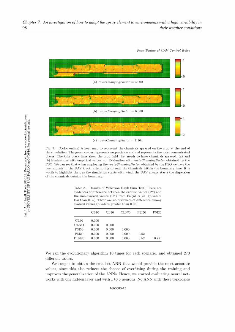
Fine-Tuning of UAV Control Rules
(a) routeChangingFactor = 3.000
(b) routeChangingFactor = 6.000
(c) routeChangingFactor = 7.164
Fig. 7. (Color online) A heat map to represent the chemicals sprayed on the crop at the end of
the simulation. The green colour represents no pesticide and red represents the most concentrated
places. The thin black lines show the crop field that needs to have chemicals sprayed. (a) and(b) Evaluations with empirical values. (c) Evaluation with routeChangingFactor obtained by the
PSO. We can see that when employing the routeChangingFactor obtained by the PSO we have the
best adjusts in the UAV track, attempting to keep the chemicals within the boundary lane. It isworth to highlight that, as the simulation starts with wind, the UAV always starts the dispersion
of the chemicals outside the boundary.
Table 3. Results of Wilcoxon Rank Sum Test. There are
evidences of difference between the evolved values (P*) andthe non-evolved values (C*) from Faical et al.; (p-values
less than 0.05). There are no evidences of difference amongevolved values (p-values greater than 0.05).
CL10 CL30 CLNO P3I50 P5I20
CL30 0.000
CLNO 0.000 0.000
P3I50 0.000 0.000 0.000
P5I20 0.000 0.000 0.000 0.52
P10I20 0.000 0.000 0.000 0.52 0.79
We ran the evolutionary algorithm 10 times for each scenario, and obtained 270
different values.
We sought to obtain the smallest ANN that would provide the most accurate
values, since this also reduces the chance of overfitting during the training and
improves the generalization of the ANNs. Hence, we started evaluating neural net-
works with one hidden layer and with 1 to 5 neurons. No ANN with these topologies
1660003-15
Int.
J.
Art
if.
Inte
ll.
To
ols
20
16
.25
. D
ow
nlo
aded
fro
m w
ww
.wo
rld
scie
nti
fic.
com
by
UN
IVE
RS
ITY
OF
SA
O P
AU
LO
on
04
/06
/16
. F
or
per
son
al u
se o
nly
.98Chapter 7. An investigation of how to adapt the spray element to environments with a high variability in
their weather conditions

B. S. Faical et al.
Fig. 8. Mean square error for 30 runs of each ANN topology.
was able to learn an accurate model from the data. therefore, the number of neurons
and the number of layers were increased, leading to the following topologies for the
first and second hidden layers: {2× 2, 4× 4, 6× 6, 8× 8, 10× 10}. The input layer
has 3 neurons and the output has one neuron (as described in Section 3.3).
The evaluated ANNs are feed-forward multi-layer perceptron and are trained
with the resilient backpropagation algorithm. The ANNs were built and trained by
employing the Stuttgart Neural Network Simulator (SNNS).c We ran the training
30 times for each of the ANN topologies and employed 3-fold cross validation.
The ANNs were trained for 2000 cycles, although we used the values of the best
generalization point. The results as mean square error (MSE) can be seen in Fig. 8.
The distributions were evaluated with statistical tests (Shapiro-Wilk) that
showed that most of the distributions cannot be accepted as normal distribu-
tions. Hence, the comparison between the distributions was carried out with the
Wilcoxon-Mann-Whitney test. When 1% of significance is considered, the com-
parisons between ANN88 and ANN1010 are equivalent. No other comparison of
distribution showed equivalence with the ANN1010 distribution. We can see that
there is an improvement from ANN22 to ANN88; however, as the statistical test
showed that ANN88 and ANN1010 are equivalent, the ANN88 was considered for
the deployment.
Figure 9 displays an execution of the ANN88. The black dots represent the
expected (original) values and the blue dots represent the values obtained by the
ANN. It can be seen that there is a good fit for most of the points; however, there are
points in which the obtained values differ from the expected. The reason for this is
that the PSO does not obtain single values while performing the evolution, i.e. there
is a group of good solutions within a range. Figure 5 can enable us to understand
which good solutions are between ≈ 3 and 6, and thus, this PSO response can be
interpreted as if the function being evolved has plateau regions. The current ANN
topology allows unique outputs for the same inputs, which might be interpreted as
a disperse value, although, the type of dispersion shown in the diagram does not
cStuttgart Neural Network Simulator, http://www.ra.cs.uni-tuebingen.de/SNNS
1660003-16
Int.
J.
Art
if.
Inte
ll.
To
ols
20
16
.25
. D
ow
nlo
aded
fro
m w
ww
.wo
rld
scie
nti
fic.
com
by
UN
IVE
RS
ITY
OF
SA
O P
AU
LO
on
04
/06
/16
. F
or
per
son
al u
se o
nly
.
99

Fine-Tuning of UAV Control Rules
Fig. 9. (Color online) Results of execution of the ANN88 for ≈ 75 different inputs. The black dots
represent the expected (original) values and blue dots represent the values obtained by the ANN.
lead to failure in the spraying operation because the obtained values are within a
suitable range.
5. Conclusions and Suggestions for Future Work
In this paper, we have proposed and evaluated a methodology based on PSO, for
fine-tuning the control rule of a UAV, and on an ANN to increase the support for
high dynamic environments. The simulations with PSO provide the optimization of
the parameter routeChangingFactor and thus reduce the error rate when spraying
pesticides on crop fields. In the first experiments, we evaluated a broad set for the
optimization method and the results show that it is possible to obtain 100% of
convergence. Applying such evolutionary methodology allowed us to increase the
precision of spraying pesticides so that ≈ 86% of the product can be applied within
a target crop field. The reason for this is that the optimization is performed during
the application and thus the parameter can be adapted to the weather conditions
of each target crop field. Although, taking into account that the spraying operation
might occur in highly dynamic environment due to changes in wind speed and
direction, we devised an ANN to be employed in the real-world operations. The
proposed ANN is trained with a dataset of near-optimal parameters obtained by
the PSO that evolves for a limited set of static environments. The ANN training
process allows it to interpolate the results as so it can be applied dynamically
for any configuration of the environment. Combining the evolutionary technique
with the neural approach in this work allowed us to leverage the best capabilities
of each technique. The presented proposal provides a significant advance in the
optimization of an UAV route which can be used in real environments, as a trained
ANN is faster than running the evolutionary process of PSO technique over and
over again whenever the weather conditions are changeable. Moreover, even if the
employed hardware has enough resources to perform the technique PSO quickly, the
1660003-17
Int.
J.
Art
if.
Inte
ll.
To
ols
20
16
.25
. D
ow
nlo
aded
fro
m w
ww
.wo
rld
scie
nti
fic.
com
by
UN
IVE
RS
ITY
OF
SA
O P
AU
LO
on
04
/06
/16
. F
or
per
son
al u
se o
nly
.100Chapter 7. An investigation of how to adapt the spray element to environments with a high variability in
their weather conditions

B. S. Faical et al.
ANN will enable the intensity of the route adjustment to be adjusted in a shorter
time.
On the basis of the results obtained the following are recommended for further
studies: (i) an investigation of how more parameters can be optimized (e.g. the
height and speed of the UAV, the best starting-position for the next crop field, and
the pressure of the spraying system); (ii) an investigation of different methodolo-
gies for the fine-tuning control rules of UAV (e.g. Differential Evolution,21 Genetic
Algorithms,22 Hill-Climbing,23 NSGA-II24); (iii) an analysis of the feasibility of
embedding the optimization methodology in the UAV, leading to an autonomous
architecture; (iv) an investigation of the methodologies required for a weather-aware
router planner.
Acknowledgments
Bruno S. Faical would like to acknowledge the funding received for your doctoral
project by FAPESP (process No. 2013/18859-8). The authors would like to acknowl-
edge the financial support granted by FAPESP (processes ID 2012/22550-0). We
also would like to thank the Office of Naval Research Global (No. 62909-14-1-N241).
Finally, the authors would like to acknowledge CAPES (Capes Foundation, Min-
istry of Education of Brazil), CNPq (Brazilian National Counsel of Technological
and Scientific Development) and FAPESP (Sao Paulo Research Foundation).
References
1. D. D. Weisenburger, Human health effects of agrichemical use, Human Pathology24(6) (1993) 571–576.
2. M. I. Tariq, S. Afzal, I. Hussain and N. Sultana, Pesticides exposure in Pakistan: Areview, Environment International 33(8) (2007) 1107–1122.
3. D. Pimentel, Amounts of pesticides reaching target pests: Environmental impacts andethics, Journal of Agricultural and Environmental Ethics 8(1) (1995) 17–29.
4. B. S. Faical et al., The use of unmanned aerial vehicles and wireless sensor networksfor spraying pesticides, Journal of Systems Architecture 60(4) (2014) 393–404.
5. B. Faical, G. Pessin, G. Filho, A. Carvalho, G. Furquim and J. Ueyama, Fine-tuningof uav control rules for spraying pesticides on crop fields, in IEEE 26th Int. Conf. onTools with Artificial Intelligence (ICTAI ) (2014), pp. 527–533.
6. J. A. Suykens, J. P. Vandewalle and B. L. de Moor, Artificial Neural Networks forModelling and Control of Non-Linear Systems (Springer Science & Business Media,2012).
7. B. Yegnanarayana, Artificial Neural Networks (PHI Learning Pvt. Ltd., 2009).8. M. Clerc and J. Kennedy, The particle swarm — Explosion, stability, and convergence
in a multidimensional complex space, IEEE Transactions on Evolutionary Computa-tion 6 (February 2002) 58–73.
9. L. M. Rios and N. V. Sahinidis, Derivative-free optimization: A review of algorithmsand comparison of software implementations, Journal of Global Optimization 56(3)(2013) 1247–1293.
10. H. Xiang and L. Tian, Development of a low-cost agricultural remote sensing systembased on an autonomous unmanned aerial vehicle (UAV), Biosystems Engineering108(2) (2011) 174–190.
1660003-18
Int.
J.
Art
if.
Inte
ll.
To
ols
20
16
.25
. D
ow
nlo
aded
fro
m w
ww
.wo
rld
scie
nti
fic.
com
by
UN
IVE
RS
ITY
OF
SA
O P
AU
LO
on
04
/06
/16
. F
or
per
son
al u
se o
nly
.
101

Fine-Tuning of UAV Control Rules
11. B. Li, R. Liu, S. Liu, Q. Liu, F. Liu and G. Zhou, Monitoring vegetation cover-age variation of winter wheat by low-altitude UAV remote sensing system, NongyeGongcheng Xuebao/Transactions of the Chinese Society of Agricultural Engineering28(13) (2012) 160–165.
12. J. Makynen, H. Saari, C. Holmlund, R. Mannila and T. Antila, Multi- and hyperspec-tral UAV imaging system for forest and agriculture applications, in Proc. of SPIE —The International Society for Optical Engineering, Vol. 8374 (Baltimore, MD, UnitedStates, 2012), The Society of Photo–Optical Instrumentation Engineers (SPIE).
13. J. Valente, D. Sanz, A. Barrientos, J. Cerro, A. Ribeiro and C. Rossi, An air-groundwireless sensor network for crop monitoring, Sensors 11(6) (2011) 6088–6108.
14. Y. Huang, W. C. Hoffmann, Y. Lan, W. Wu and B. K. Fritz, Development of a spraysystem for an unmanned aerial vehicle platform, Applied Engineering in Agriculture25(6) (2009) 803–809.
15. R. C. Eberhart and J. Kennedy, A new optimizer using particle swarm theory, inProc. of the Sixth Int. Symp. on Micro Machine and Human Science, Vol. 1 (NewYork, 1995), pp. 39–43.
16. L. A. Santana and A. M. Canuto, Particle swarm intelligence as feature selector inensemble systems, in 2013 Brazilian Conference on Intelligent Systems (BRACIS)(IEEE2013), pp. 89–94.
17. G. Pessin, F. S. Osorio, J. R. Souza, J. Ueyama, F. G. Costa, D. F. Wolf, D. Dimi-trova, T. Braun and P. A. Vargas, Investigation on the evolution of an indoor roboticlocalization system based on wireless networks, Applied Artificial Intelligence 27(8)(2013) 743–758.
18. A. Varga, OMNeT++, in Modeling and Tools for Network Simulation, eds. K. Wehrle,M. Gunes and J. Gross (Springer Berlin Heidelberg, 2010), pp. 35–59.
19. J. G. K. Wehrle and M. Gunes, Modeling and Tools for Network Simulation (Springer,2005).
20. A. Kopke, M. Swigulski, K. Wessel, D. Willkomm, P. T. K. Haneveld, T. E. V. Parker,O. W. Visser, H. S. Lichte and S. Valentin, Simulating wireless and mobile networksin OMNeT++ the MiXiM vision, in Proc. of the 1st Int. Conf. on Simulation Toolsand Techniques for Communications, Networks and Systems & Workshops SIMU-Tools ’08 (Institute for Computer Sciences, Social-Informatics and Telecommunica-tions Engineering, 2008), pp. 71:1–71:8.
21. K. Price, R. M. Storn and J. A. Lampinen, Differential Evolution: A PracticalApproach to Global Optimization (Springer Science & Business Media, 2006).
22. S.-F. Kuo, G. P. Merkley and C.-W. Liu, Decision support for irrigation projectplanning using a genetic algorithm, Agricultural Water Management 45(3) (2000)243–266.
23. H. Muhlenbein, Evolution in time and space — The parallel genetic algorithm, inFoundations of Genetic Algorithms (1991).
24. K. Deb, A. Pratap, S. Agarwal and T. Meyarivan, A fast and elitist multiobjectivegenetic algorithm: NSGA-II, IEEE Transactions on Evolutionary Computation 6(2)(2002) 182–197.
1660003-19
Int.
J.
Art
if.
Inte
ll.
To
ols
20
16
.25
. D
ow
nlo
aded
fro
m w
ww
.wo
rld
scie
nti
fic.
com
by
UN
IVE
RS
ITY
OF
SA
O P
AU
LO
on
04
/06
/16
. F
or
per
son
al u
se o
nly
.102Chapter 7. An investigation of how to adapt the spray element to environments with a high variability in
their weather conditions

103
CHAPTER
8
FINAL CONSIDERATIONS
8.1 Conclusions
Precision Agriculture (PA) is one of the alternative ways of increasing agricultural
production. PA can be defined as the use of technology in the field and boosting production
by processing the needs of the crops in a space-time relationship. In this way, a management
system can be carried out which is geared towards the real needs of each agricultural region.
This approach makes it possible to increase the yield of agricultural production to a higher level
than what was achieved by the use of traditional techniques in a crop field of the same size.
In spite of the well-known and significant advances made in the field of PA, it clearly re-
mains a challenge to carry out the spraying of plant protection products in agricultural plantations
with precision. The weather conditions of the region can cause drift from the spray product to
neighboring regions which is harmful to the environment and reduces the efficiency of protection
management. However, this practice is essential for agriculture where there is a need for pest
control to boost production. Studies have shown that if the protection management is not carried
out properly (which can be explained as an inappropriate configuration of the spraying system for
the weather conditions at the time of its application), only a small amount of the spray product
will be really deposited on the targeted region, while most will form a part of the drift that is
blown to other areas.
Mathematical models are often employed to estimate the path followed and the physical
transformation of each spray particle until its final condition is attained. This condition might be
the complete evaporation of the particle or its deposition on a particular surface (for example
the soil or the crop). Studies are being carried out on the basis of these calculations of the final
position of each particle and these can allow estimates to be made of the concentration of the
product deposited in each area. Nonetheless, it should be noted that this approach is expensive in
computational terms, both for its execution and management. For example, if an autonomous

104 Chapter 8. Final Considerations
spray vehicle has to make an estimate of the precision of the spraying procedure, this approach
will not allow this to be undertaken during the appropriate time needed for its operation.
This thesis explores approaches which allow estimates to be made of the concentration
of plant protection products in targeted areas, rapidly and with a reasonable degree of accuracy.
These might involve autonomous sprayers being able to adapt to the weather conditions of the
region of interest to achieve a more precise protection management which is less harmful to
the environment. For this reason, the thesis investigates the use of Machine Learning (ML)
techniques, together with a computing model based on the essential features of the problem
being addressed. In addition, a case study was conducted on an autonomous platform for spaying,
consisting of a UAV and a WSN. In this study, the UAV is the spray element ( a vehicle fitted
with a spray system) which flies over the crop field and is guided by the spray tracks so that it
can deposit the plant protection products on the crop; and the WSN is the support element that
provides information about the remote sensing of the weather conditions and the concentration
of the product deposited along the spray tracks for the UAV.
The computing model for the environment calculates the trajectory of each particle
on the basis of a dispersion model that takes account of the meteorological information and
the features of the spraying system. The trajectory of the particles shows their respective final
positions and this makes it possible to estimate the deposition of the product in the targeted area
or the amount that is being deposited in neighboring regions. This information is represented
by designing a matrix of a size that is proportional to the region of interest, where each cell
stores the estimated concentration for the final position of the particles. Furthermore, the model
represents the operation of the platform for the spraying in the region of interest and this makes
it possible to assess the degree of precision of the spraying in particular weather conditions.
Contributions made by this study to the research field
1. – Adjustment to environments with a low variability of weather conditions
The approach described for the computing model can be linked to meta-heuristic algo-
rithms as a part of the fitness function. This was supplemented by adding an element to the
analysis of the deposition matrix to check if the targeted region is being sprayed and giving a
response to the question of the number of particles deposited in the neighboring areas.Thus,
the fitness of the solutions provided by the meta-heuristic algorithms must have the minimized
values to represent a more precise spraying (with less drift). Finally, the fitness function only
makes use of deterministic variables in the computing model to ensure that a fair comparison is
made between the possible solutions.
The use of meta-heuristic algorithms with the fitness function described earlier, has
proved to be an efficient way to estimate the deposition of the spray product with a view to
adjusting the image intensity to the UAV route correctly. As a result, it has become possible to
adapt the mechanical behaviour of the UAV to the weather conditions of the environment for

8.2. Plans for Future Work 105
more precise spraying and thus reduce the drift of plant protection products to neighboring areas.
There was an assessment of the evolving pattern of this approach since its efficiency
can be impaired if an environment is chosen with constantly shifting weather patterns and the
meta-heuristic algorithm must be repeatedly executed for each new sub-area.
2. – Adjustment to environments with a high variability of weather conditions
Although the execution of the meta-heuristic algorithms requires a relatively long space
of time (for example, in scenarios where there is a need to carry out the adaptation in a short
space of time), Machine Learning techniques can be used to make the processing more versatile.
In Faiçal et al. (2016b), it is shown that an ANN can be used to indicate the possible results of
the meta-heuristic algorithm without the need for it to be re-executed for each new sub-area.
In addition, this approach allows the intensity correction of the route to be indicated with a
reasonable degree of accuracy for the unknown weather conditions during the training phase.
Hence, an ANN that has been previously trained, can replace the meta-heuristic algorithm to
indicate the correction of the route during the spraying of the plant protection products.
Finally, it is believed that the articles that have originated from this thesis show that the
new approaches and their evaluation allow the spray element to have their operations adapted to
the features of the environment so that a more precise kind of protection management can be
provided, even in environments that need to be upgraded in a short space of time.
8.2 Plans for Future Work
After completing this research study, it is possible to envisage areas that might be
explored in further studies, such as the following:
∙ Examining new approaches for the reduction of computational costs, which are incurred
by estimating the deposition of the spray product;
∙ The use of Computational Intelligence concepts to assess show different features of the
spray element can be adapted to the environment as a means of reducing the drift of the
spray product;
∙ Investigating the scalability of the proposal in environments where there is more than one
sprayer;
∙ Exploring the feasibility of making adjustments to the performance of terrestrial vehicles;
∙ Carrying out experiments in real-world environments in which the techniques validated
in real hardware are embedded, such as the spraying system that was designed and

106 Chapter 8. Final Considerations
implemented during the course of this thesis. This system can be found under patent
No. BR 10 2016 029353 71.
1 The request for protection was deposited with the Instituto Nacional da Propriedade Industrial (INPI)on December 14, 2016.
107
BIBLIOGRAPHY
BAETENS, K.; NUYTTENS, D.; VERBOVEN, P.; SCHAMPHELEIRE, M. D.; NICOLAÏ, B.;RAMON, H. Predicting drift from field spraying by means of a 3d computational fluid dynamicsmodel. Computers and Electronics in Agriculture, Elsevier, v. 56, n. 2, p. 161–173, 2007.Citation on page 22.
CUNHA, J. P. A. R. D. Simulação da deriva de agrotóxicos em diferentes métodos de aplicação.Revista Ciência Agronômica, v. 39, n. 4, p. 487–493, 2009. Citation on page 22.
CUNHA, J. P. A. R. D.; REIS, E. F. D.; SANTOS, R. D. O. Controle químico da ferrugemasiática da soja em função de ponta de pulverização e de volume de calda. Ciência Rural,SciELO Brasil, v. 36, n. 5, p. 1360–1366, 2006. Citation on page 22.
CUNHA, J. P. A. R. D.; TEIXEIRA, M. M.; VIEIRA, R. F. Avaliação de pontas de pulverizaçãohidráulicas na aplicação de fungicida em feijoeiro. Ciência Rural, SciELO Brasil, v. 35, n. 5, p.1069–1074, 2005. Citation on page 22.
CUNHA, P. A. R. D. Pesticide drift simulation under different application methods. Revista
Ciência Agronômica, Universidade Federal do Ceará, Centro de Ciências Agrárias, v. 39, n. 4,p. 487, 2008. Citation on page 22.
DAVIS, B.; WILLIAMS, C. Buffer zone widths for honeybees from ground and aerial sprayingof insecticides. Environmental Pollution, Elsevier, v. 63, n. 3, p. 247–259, 1990. Citation onpage 20.
DEVARREWAERE, W.; JANSSEN, S.; FOQUÉ, D.; NUYTTENS, D.; HEIMBACH, U.; NICO-LAI, B.; VERBOVEN, P. Cfd modelling to simulate dust emissions from pneumatic seed drills.In: ASSOCIATION OF APPLIED BIOLOGISTS. Aspects of Applied Biology. [S.l.], 2016.v. 132, p. 227–234. Citation on page 22.
DORNELLES, M. E.; SCHLOSSER, J. F.; BOLLER, W.; RUSSINI, A.; CASALI, A. L. In-speção técnica de tratores e pulverizadores utilizados em pulverização agrícola. Engenharia na
Agricultura, v. 19, n. 1, p. 36–43, 2011. Citations on pages 19 and 20.
DORUCHOWSKI, G.; ROETTELE, M.; HERBST, A.; BALSARI, P. Drift evaluation toolto raise awareness and support training on the sustainable use of pesticides by drift mitiga-tion. Computers and Electronics in Agriculture, v. 97, p. 27 – 34, 2013. ISSN 01681699.Adjacent structures;Application parameters;Application softwares;Decision supports;Pesticideapplications;Practical recommendation;Risk mitigation;Sustainable use of pesticides;. Available:<http://dx.doi.org/10.1016/j.compag.2013.06.006>. Citations on pages 21 and 22.
EBERHART, R. C.; SHI, Y. Computational intelligence: concepts to implementations. [S.l.]:Elsevier, 2011. Citation on page 23.
FAIÇAL, B.; PESSIN, G.; FILHO, G.; CARVALHO, A.; FURQUIM, G.; UEYAMA, J. Fine-tuning of uav control rules for spraying pesticides on crop fields. In: Tools with Artificial

108 Bibliography
Intelligence (ICTAI), 2014 IEEE 26th International Conference on. [S.l.: s.n.], 2014. p.527–533. ISSN 1082-3409. Citations on pages 28 and 29.
FAIÇAL, B. S.; COSTA, F. G.; PESSIN, G.; UEYAMA, J.; VIEIRA, H. F.; COLOMBO, A.;FINI, P. H.; VILLAS, L.; OSÓRIO, F. S.; VARGAS, P. A. et al. The use of unmanned aerialvehicles and wireless sensor networks for spraying pesticides. Journal of Systems Architecture,Elsevier, 2014. Citation on page 27.
FAIÇAL, B. S.; FREITAS, H.; GOMES, P. H.; MANO, L. Y.; PESSIN, G.; CARVALHO,A. C. P. L. F.; KRISHNAMACHARI, B.; UEYAMA, J. An adaptive approach for uav-basedpesticide spraying in dynamic environments. Computers and Electronics in Agriculture - IN
PROGRESS, 2016. Citation on page 29.
FAIÇAL, B. S.; PESSIN, G.; FILHO, G. P. R.; CARVALHO, A. C. P. L. F.; GOMES, P. H.;UEYAMA, J. Fine-tuning of uav control rules for spraying pesticides on crop fields: An ap-proach for dynamic environments. International Journal on Artificial Intelligence Tools,v. 25, n. 01, p. 1660003, 2016. Available: <http://www.worldscientific.com/doi/abs/10.1142/S0218213016600034>. Citations on pages 29 and 105.
FAIÇAL, B. S.; PESSIN, G.; FILHO, P. G.; FURQUIM, G.; CARVALHO, A. C. de; UEYAMA, J.Exploiting evolution on uav control rules for spraying pesticides on crop fields. In: Engineering
Applications of Neural Networks. [S.l.]: Springer, 2014. p. 49–58. Citation on page 28.
FAIÇAL, B. S.; UEYAMA, J. .; CARVALHO, A. C. P. L. F. The use of autonomous uavsto improve pesticide application in crop fields. In: High Velocity Mobile Data Mining, 1st
Workshop on. [S.l.: s.n.], 2016. Citation on page 30.
FAO Trade and Markets Division. Food Outlook: Biannual Report on Global Food Markets.[S.l.], 2014. Access date: 2014.12.30 <http://www.fao.org/3/a-i4136e.pdf>. Citation on page19.
FERREIRA, M. C.; LOHMANN, T. R.; CAMPOS, A. P.; VIEL, S. R.; FIGUEIREDO, A.Distribuição volumétrica e diâmetro de gotas de pontas de pulverização de energia hidráulicapara controle de corda-de-viola. Planta daninha, Sociedade Brasileira da Ciência das PlantasDaninhas, p. 697–705, 2011. Citation on page 22.
FERREIRA, M. d. C.; OLIVEIRA, J. R. D.; PIETRO, I. R. d. S. D. Distribuição da caldaherbicida por pontas de pulverização agrícola utilizadas em áreas de reflorestamento comeucalipto. Engenharia Agrícola, Associação Brasileira de Engenharia Agrícola (SBEA), p.267–276, 2009. Citations on pages 19, 20, and 21.
FRIEDRICH, T.; RAETANO, C.; ANTUNIASSI, U. Quality in pesticide application technology.Qualidade em tecnologia de aplicação. Botucatu: Fepaf, p. 93–109, 2004. Citation on page22.
GERLAND, P.; RAFTERY, A. E.; ŠEVCÍKOVÁ, H.; LI, N.; GU, D.; SPOORENBERG, T.;ALKEMA, L.; FOSDICK, B. K.; CHUNN, J.; LALIC, N.; BAY, G.; BUETTNER, T.; HEILIG,G. K.; WILMOTH, J. World population stabilization unlikely this century. Science, AmericanAssociation for the Advancement of Science, v. 346, n. 6206, p. 234–237, 2014. ISSN 0036-8075.Available: <http://science.sciencemag.org/content/346/6206/234>. Citation on page 19.

Bibliography 109
GHATE, S.; PERRY, C. Ground speed control of pesticide application rates in a compressedair direct injection sprayer. Transactions of the American Society of Agricultural Engineers,v. 37, n. 1, p. 33 – 38, 1994. ISSN 00012351. Direct injection sprayer;Ground speed control;.Citations on pages 20 and 22.
GO, J.; BROWNING, B.; VELOSO, M. Accurate and flexible simulation for dynamic, vision-centric robots. In: Proceedings of the Third International Joint Conference on Autonomous
Agents and Multiagent Systems (AAMAS). [S.l.]: IEEE Computer Society, 2004. v. 3, p.1388–1389. Citation on page 24.
GREGORIO, E.; TORRENT, X.; MARTI, S. P. de; SOLANELLES, F.; SANZ, R.; ROCA-DENBOSCH, F.; MASIP, J.; RIBES-DASI, M.; ROSELL-POLO, J. R. Measurement of spraydrift with a specifically designed lidar system. Sensors (Switzerland), v. 16, n. 4, 2016. ISSN14248220. Erbium doped glass;Experimental campaign;Integrated measurements;Lidar measure-ments;Light detection and ranging techniques;Real time measurements;Spray drift;Temporaland spatial;. Available: <http://dx.doi.org/10.3390/s16040499>. Citations on pages 20 and 22.
GRIFOLL, J.; ROSELL-LLOMPART, J. Efficient lagrangian simulation of electrospraydroplets dynamics. Journal of Aerosol Science, v. 47, p. 78 – 93, 2012. ISSN00218502. Axial regions;Count mean diameter;CPU time;Different time steps;Electricalforce;Electrospray;Electrospray droplets;Electrosprays;Electrostatic repulsion forces;Highertime resolution;Integration time;Lagrangian;Lagrangian simulation;Numerical collisions;Spacecharge forces;Steady state;Time step;Upper Bound;. Available: <http://dx.doi.org/10.1016/j.jaerosci.2012.01.001>. Citation on page 22.
GUO, B.; FLETCHER, D. F.; LANGRISH, T. A. Simulation of the agglomeration in a sprayusing lagrangian particle tracking. Applied Mathematical Modelling, v. 28, n. 3, p. 273 – 290,2004. ISSN 0307904X. Eulerian-Lagrangian approach;. Available: <http://dx.doi.org/10.1016/S0307-904X(03)00133-1>. Citation on page 22.
HALLMANN, M.; SCHEURLEN, M.; WITTIG, S. Computation of turbulent evaporating sprays:Eulerian versus lagrangian approach. In: . Cincinnati, OH, USA: [s.n.], 1993. p. 1 – 10. ISSN04021215. Eulerian model;Lagrangian model;. Citation on page 22.
HUANG, Y.; HOFFMANN, W. C.; LAN, Y.; WU, W.; FRITZ, B. K. Development of a spraysystem for an unmanned aerial vehicle platform. Applied Engineering in Agriculture, v. 25(6),p. 803–809, 2009. Citations on pages 20 and 21.
JAKOBI, N.; HUSB, P.; HARVEY, I. Noise and the reality gap: The use of simulation in evolu-tionary robotics. In: Advances in Artificial Life: Proceedings of 3rd European Conference
on Artificial Life. [S.l.: s.n.], 1995. p. 704–720. Citation on page 24.
JIAO, L.; DONG, D.; FENG, H.; ZHAO, X.; CHEN, L. Monitoring spray drift in aerial sprayapplication based on infrared thermal imaging technology. Computers and Electronics in
Agriculture, v. 121, p. 135 – 140, 2016. ISSN 01681699. Concentration distributions;Imageprocessing algorithm;Infrared thermal imaging;Infrared thermal imaging systems;Real timemeasurements;Spray application;Spray drift;Water sensitive paper;. Available: <http://dx.doi.org/10.1016/j.compag.2015.12.006>. Citations on pages 20 and 22.
JOHNSON, A. T. Food for the future [state of the art]. IEEE Pulse, v. 7, n. 3, p. 48 – 49 and57, 2016. ISSN 21542287. Food production;Political impact;Population growth;State of the art;.Available: <http://dx.doi.org/10.1109/MPUL.2016.2538483>. Citation on page 19.
110 Bibliography
LEI. Lei no 7.802, de 11 de Julho de 1989. [S.l.], 1989. Access date: 2014.12.30 <http://www.planalto.gov.br/ccivil_03/leis/l7802.htm>. Citation on page 19.
MARSILY, G. de; RIO, R. Abarca-del. Water and food in the twenty-first century. Surveys in
Geophysics, v. 37, n. 2, p. 503–527, 2016. ISSN 1573-0956. Available: <http://dx.doi.org/10.1007/s10712-015-9335-1>. Citation on page 19.
MINOV, S. V.; COINTAULT, F.; VANGEYTE, J.; PIETERS, J. G.; NUYTTENS, D. Spraydroplet characterization from a single nozzle by high speed image analysis using an infocusdroplet criterion. Sensors (Switzerland), v. 16, n. 2, 2016. ISSN 14248220. Droplet gener-ators;Focus characteristic;High speed image analysis;Image acquisition and analysis;PhaseDoppler particle analyzer;Piezoelectric generators;Proof of principles;Spray characterizations;.Available: <http://dx.doi.org/10.3390/s16020218>. Citations on pages 20 and 22.
NIJDAM, J.; GUO, B.; FLETCHER, D.; LANGRISH, T. Validation of the lagrangian approachfor predicting turbulent dispersion and evaporation of droplets within a spray. Drying Tech-
nology, v. 24, n. 11, p. 1373 – 1379, 2006. ISSN 07373937. Lagrangian approach;Particledrying;Spray drying;. Available: <http://dx.doi.org/10.1080/07373930600952412>. Citation onpage 22.
NIJDAM, J. J.; GUO, B.; FLETCHER, D. F.; LANGRISH, T. A. Lagrangian and eulerian modelsfor simulating turbulent dispersion and coalescence of droplets within a spray. Applied Math-
ematical Modelling, v. 30, n. 11, p. 1196 – 1211, 2006. ISSN 0307904X. Droplets;Eulerianmodels;Lagrangian models;Spray;. Available: <http://dx.doi.org/10.1016/j.apm.2006.02.001>.Citation on page 22.
NUYTTENS, D.; SCHAMPHELEIRE, M. D.; BAETENS, K.; BRUSSELMAN, E.;DEKEYSER, D.; VERBOVEN, P. Drift from field crop sprayers using an integrated approach:Results of a five-year study. Transactions of the ASABE, v. 54, n. 2, p. 403 – 408, 2011. ISSN21510032. Drift mitigation;Drift model;Field crop sprayers;Spray application technology;Spraydrift;. Citations on pages 21 and 22.
PEDERI, Y.; CHEPORNIUK, H. Unmanned aerial vehicles and new technological methodsof monitoring and crop protection in precision agriculture. In: IEEE. Actual Problems of Un-
manned Aerial Vehicles Developments (APUAVD), 2015 IEEE International Conference.[S.l.], 2015. p. 298–301. Citation on page 21.
PERECIN, D.; PERESSIN, V. A.; MATUO, T.; BRAZ, B. A.; PIO, L. C. Padrões de dis-tribuição de líquidos obtidos com bicos tf-vs4, tj60-11006 e tq15006 em mesa de prova. Pesquisa
Agropecuária Brasileira, p. 175–182, 1998. Citation on page 21.
. Avaliação do desempenho de bicos para aplicação de herbicidas. Planta Daninha, SciELOBrasil, v. 17, n. 1, p. 345–354, 1999. Citations on pages 20 and 21.
PIMENTEL, D. Amounts of pesticides reaching target pests: environmental impacts and ethics.Journal of Agricultural and environmental Ethics, Springer, v. 8, n. 1, p. 17–29, 1995. Cita-tions on pages 20 and 21.
QIN, W.-C.; QIU, B.-J.; XUE, X.-Y.; CHEN, C.; XU, Z.-F.; ZHOU, Q.-Q. Droplet depositionand control effect of insecticides sprayed with an unmanned aerial vehicle against plant hoppers.Crop Protection, Elsevier, v. 85, p. 79–88, 2016. Citation on page 21.
Bibliography 111
RU, Y.; JIN, L.; ZHOU, H.; JIA, Z. Performance experiment of rotary hydraulic atomizingnozzle for aerial spraying application. Nongye Gongcheng Xuebao/Transactions of the Chi-
nese Society of Agricultural Engineering, v. 30, n. 3, p. 50 – 55, 2014. ISSN 10026819.Comprehensive performance;Deposition distribution;Nozzle atomizations;Operating parame-ters;Optimum parameters;Performance experiment;Structure parameter;Unmanned helicopter;.Available: <http://dx.doi.org/10.3969/j.issn.1002-6819.2014.03.007>. Citation on page 21.
SAHA, A.; PIPARIYA, A.; BHADURI, D. Enzymatic activities and microbial biomass in peanutfield soil as affected by the foliar application of tebuconazole. Environmental Earth Sciences,v. 75, n. 7, 2016. ISSN 18666280. Nitrogen transformations;Peanut;Soil health;Soil microbialbiomass;Tebuconazole;. Available: <http://dx.doi.org/10.1007/s12665-015-5116-x>. Citationon page 20.
SALYANI, M.; CROMWELL, R. Spray drift from ground and aerial applications. Transactions
of the American Society of Agricultural Engineers, v. 35, n. 4, p. 1113 – 1120, 1992. ISSN00012351. Aerial applications;Citrus;Florida;Ground applications;Spray drift;Spray solutions;.Citations on pages 20, 21, and 22.
SMITH, D. Uniformity and recovery of broadcast sprays using fan nozzles. Transactions of the
ASAE, American Society of Agricultural and Biological Engineers, v. 35, n. 1, p. 39–44, 1992.Citation on page 21.
SUBRAMANIAM, S. Lagrangian–eulerian methods for multiphase flows. Progress in Energy
and Combustion Science, v. 39, n. 2–3, p. 215 – 245, 2013. ISSN 0360-1285. Available:<http://www.sciencedirect.com/science/article/pii/S0360128512000603>. Citation on page 22.
TARIQ, M. I.; AFZAL, S.; HUSSAIN, I.; SULTANA, N. Pesticides exposure in pakistan:A review. Environment International, v. 33, n. 8, p. 1107 – 1122, 2007. ISSN 0160-4120.Available: <http://www.sciencedirect.com/science/article/pii/S0160412007001389>. Citationon page 20.
WANG, R.; DORR, G.; HEWITT, A.; COOPER-WHITE, J. Impacts of polymer/surfactant inter-actions on spray drift. Colloids and Surfaces A: Physicochemical and Engineering Aspects,v. 500, p. 88 – 97, 2016. ISSN 09277757. Atomisation;Droplet size distributions;Dynamic surfacetensions;Extensional viscosity;Polymer chain dynamics;Polymer/surfactant interactions;Spraydrift;. Available: <http://dx.doi.org/10.1016/j.colsurfa.2016.03.056>. Citation on page 20.
WANG, X.; HE, X.; HERBST, A.; LANGENAKENS, J.; ZHENG, J.; LI, Y. Development and per-formance test of spray drift test system for sprayer with bar. Nongye Gongcheng Xuebao/Trans-
actions of the Chinese Society of Agricultural Engineering, v. 30, n. 18, p. 55 – 62, 2014.ISSN 10026819. Air-assisted spraying;Boom sprayer;International standards;Meteorological con-dition;Meteorological factors;Potential drift;Sedimentation velocities;Test systems;. Available:<http://dx.doi.org/10.3969/j.issn.1002-6819.2014.18.007>. Citation on page 21.
WEISENBURGER, D. D. Human health effects of agrichemical use. Human Pathology, v. 24,n. 6, p. 571 – 576, 1993. ISSN 0046-8177. Available: <http://www.sciencedirect.com/science/article/pii/0046817793902348>. Citations on pages 19 and 20.
WOLF, D.; SMITH, E. Uniformity of seed and fertilizer distribution with a hand-operatedspinning spreader. Transactions of the ASAE, American Society of Agricultural and BiologicalEngineers, v. 22, n. 4, p. 761–0762, 1979. Citation on page 21.

112 Bibliography
XIANG, H.; TIAN, L. Development of a low-cost agricultural remote sensing system basedon an autonomous unmanned aerial vehicle (uav). Biosystems Engineering, 24-28 Oval Road,London, NW1 7DX, United Kingdom, v. 108, n. 2, p. 174 – 190, 2011. ISSN 15375110. Available:<http://dx.doi.org/10.1016/j.biosystemseng.2010.11.010>. Citation on page 20.
ZHU, H.; LAN, Y.; WU, W.; HOFFMANN, W. C.; HUANG, Y.; XUE, X.; LIANG, J.; FRITZ,B. Development of a pwm precision spraying controller for unmanned aerial vehicles. Journal
of Bionic Engineering, Elsevier, v. 7, n. 3, p. 276–283, 2010. Citation on page 21.
113
APPENDIX
A
DISSEMINATION OF THE RESULTS
ACHIEVED IN THIS THESIS

The use of autonomous UAVs to improve pesticideapplication in crop fields
Autonomous UAV, Pesticide application, Optimization, Machine learning
Bruno S. Faical∗†, Jo Ueyama∗, Andre C. P. L. F. de Carvalho∗
∗Institute of Mathematics and Computer Science (ICMC)University of Sao Paulo (USP)
Sao Carlos, SP - BrazilEmail: {bsfaical;joueyama;andre}@icmc.usp.br
†Technological Sciences Center (CCT)State University of Northern Parana (UENP)
Bandeirantes, PR - BrazilEmail: [email protected]
Abstract—The population growth, increase of need for healthyfood and concerns regarding wildlife protection put a strongdemand in the improvement of agriculture productivity, re-duction of the presence of pesticides in fruits and vegetablesand of wildlife contamination. Agriculture production needs theapplication of pesticides to keep the necessary productivity levels.The use of autonomous aircrafts in the application of pesticidescan increase the application precision efficiency, reducing theharm to human beings and nature. Weather conditions, like windintensity and direction during the spraying, make the aircraftcontrol difficult. This talk will present a the use of autonomousUAVs able to self-adjust their routes when spraying pesticides incrop fields.
I. MOTIVATIONAgriculture plays an important role in the economy of many
countries, one of them Brazil. Farm activities in these countriesextensively use pesticides to eliminate diseases and plagues inorder to increase crop productivity. Noways, the application ofpesticides occurs mainly through the use of aircrafts. Aircraftscan avoid problems due to adverse ground conditions that affectthe use of ground equipments, like areas with obstacles, likesteeply sloping land and tree limbs. Besides being able to avoidground obstacles, aircrafts can, in the same period of time, covera larger area than ground equipments. Thus, aircrafts are moreadvantages when the ground presents obstacles and pesticideapplication must be carried out in a short period of time.
Usually, these aircrafts are on-board piloted and the pilotsmust attend several requirements and take specific examinationsto become commercial pesticide applicators. However, due toexternal occurrences, like changes in wind direction and velocity,the precision required by the spraying process on crop fieldsis frequently is not fulfilled. This occurs because, as a result,pesticides applied by these aircrafts can end up in other areasnearby, affecting recreation areas, other crop cultures and natu-ral resources. Besides, even using personal protective equipmentsand complying with all safety requirements, pilots of pesticideapplication aircrafts, can be exposed to pesticides, which cancause serious damages to their health. Unmanned aerial vehicle(UAV) have been used to reduce this problems and there arecommercial UAVs for such. However, most solutions use anhuman pilot who may not be able to react fast to changes inweather conditions, is prone to subjective mistakes and, if close
to the crop filed being sprayed, what is usually the case, is stillexposed to the pesticides.
II. EXPERIMENTS
This study shows how changes in weather condition and harmto human health can be overcome by using an autonomous UAV.To provide autonomy to the UAV, optimization and machinelearning techniques are embed into the UAV. As a result, theUAV can accurately spray pesticides on the target crop field,correct its route autonomously to take into account changes inthe environment conditions. The optimization technique is usedto find near-optimal flight control parameter values for staticenvironments. For such, several optimization techniques wereinvestigated and, because it presented the best performance,Particle Swarm Optimization (PSO) was used. The machinelearning technique is used to induce a model able to makeinterpolations of the best solutions found by PSO to improve theUAV route in dynamic environments. For such, artificial neuralnetworks (ANNs) were used. This hybrid intelligent approachwas embedded in UAVs with programmable boards, such asRaspberry PIs or Beaglebones.
Fig. 1. UAV used in the experi-ments.
Several experiments were car-ried out to evaluate the proposedapproach. According to the ex-perimental results, the proposedapproach is feasible and meets therequirements of a fast responsetime needed by the UAV to adjustits route in a highly dynamic envi-ronment, while accurately spray-ing pesticides in a crop field. Thecombination of PSO and ANNs
improved the spraying precision in dynamic environments, whencompared, during the UAV activity, with the optimization tech-niques alone. for static environments, such as PSO exclusiveuse during activity. It is important to observe that PSO needsto perform a large number of evaluations, where they use asimulator that has a high computational cost. Thus, given thetime limit required to perform these assessments, the use ofjust PSO is suitable only in environments with a low rate ofenvironmental change. Figure 1 illustrates the UAV used in theexperiments.
2016 17th IEEE International Conference on Mobile Data Management
2375-0324/16 $31.00 © 2016 IEEE
DOI 10.1109/MDM.2016.96
32
2016 17th IEEE International Conference on Mobile Data Management
2375-0324/16 $31.00 © 2016 IEEE
DOI 10.1109/MDM.2016.96
32
114 APPENDIX A. Dissemination of the results achieved in this thesis
III. NEXT STEPS
The experimental results obtained in the experiments carriedout using the proposed approach showed new challenges thatneed to be addressed, which are (i) Reduce the computationalcost of the computational model used for pesticide spraying (ii)optimize other parameters (e.g. height and speed of the UAVs)to improve the precision of pesticide deposition; (iii) incorporatecharacteristics specific of optimization techniques for dynamicenvironments; (iv) investigate the scalability of the proposedsystem for the implementation of a fully-featured prototypemodel.
BIBLIOGRAPHICAL SKETCH
Andre C. P. L. F. de Carvalhoreceived his B.Sc. and M.Sc. de-grees in Computer Science fromthe Universidade Federal de Per-nambuco, Brazil. He received hisPh.D. degree in Electronic En-gineering from the University ofKent, UK. Prof. Andr de Carvalhois Full Professor at the Depart-ment of Computer Science, Uni-
versidade de So Paulo, Brazil. He has been in the ProgramCommittee of several conferences in Data Mining and Ma-chine Learning and is a member of Journal Editorial Boardsin these areas. His main interests are Data Science, MachineLearning and Data Mining, particular Data Stream Mining andMetalearning.
Jo Ueyama completed his Ph.D.in computer science at the Uni-versity of Lancaster (England) in2006. He was also a research fel-low at the University of Kent atCanterbury (England) before join-ing the University of So Paulo(USP) . Jo is currently an Asso-ciate Professor at the Institute ofMathematics and Computer Sci-ence at USP. He is also a BrazilianResearch Council (CNPq) fellow.Jo has published 25 journal arti-cles and over than 60 conference
papers. His main research interest includes Computer Net-works and Distributed Systems. His main research interestincludes investigating on how to enhance intelligence onInternet of Thing devices, such as UAVs, smartphones andsensors.
Bruno S. Faical is Ph.D. studentat the Institute of Mathematics andComputer Science of the Univer-sity of Sao Paulo and Teachingassociate at the State Universityof Northern Parana. He obtainedan M.S. in Computer Science in2012 from the University of theSao Paulo. At ICMC/USP, he has
been working on several researchprojects related to Machine Learn-
ing, Wireless Sensor Networks, Computational Intelligenceand Unmanned Aerial Vehicles.
ACKNOWLEDGMENT
This work was supported by grants from CAPES, CNPq,FAPESP (grant #2013/18859-8) and CeMEAI-FAPESP (grant#13/07375-0), Brazilian funding agencies.
3333
115