the use of geostatistics in the evaluation of commercial ground risk …ags-hk.org/notes/14/04_angus...
TRANSCRIPT

Quantitative Geological Modelling
The Use of Geostatistics in the Evaluation of Commercial Ground Risk in Tunnel and
Excavation Projects
Dr Angus MaxwellMaxwell Geosystems Ltd.

Quantitative Geological Modelling
Objective of GBRs
• Fair apportioning of ground risk

Quantitative Geological Modelling
Objectives of GBRs
• The risk is mainly due to uncertainty

Quantitative Geological Modelling
Objectives of GBRs
• The objective is to quantify uncertainty

Quantitative Geological Modelling
How to do this?
• Deterministic Models– We pretend we know everything
• Stochastic Models– We assume we know nothing and that
variations are represented only by data variations

Quantitative Geological Modelling
Deterministic Models
We know everything.

Quantitative Geological Modelling
Problems with Deterministic Models
• Subjective• One of many which fit the data• Experience or pre-conception• Not transparent (based on a database of
information which is not available to others)• Not defendable

Quantitative Geological Modelling
Standard Statistical ModelsWe know nothing.
nszxUCL
Where: x = the mean
Z = the confidence interval (ie 0.95 for 95%)
s i= the standard deviation
n = the number of data values
N
X

Quantitative Geological Modelling
Problems with Basic Statistical Models• Ideal Data Set
– Random Samples
– Unclustered Data
– Uncorrelated Data
• Typical Field Data
– Biased towards construction zones
– Clustered around critical spots
– Correlated due to geological processes

Quantitative Geological Modelling
Basic Statistics are InadequateThey do not assess spatial distribution
N
X
N
X
Same statistical distribution – different impact
Quantitative Geological Modelling
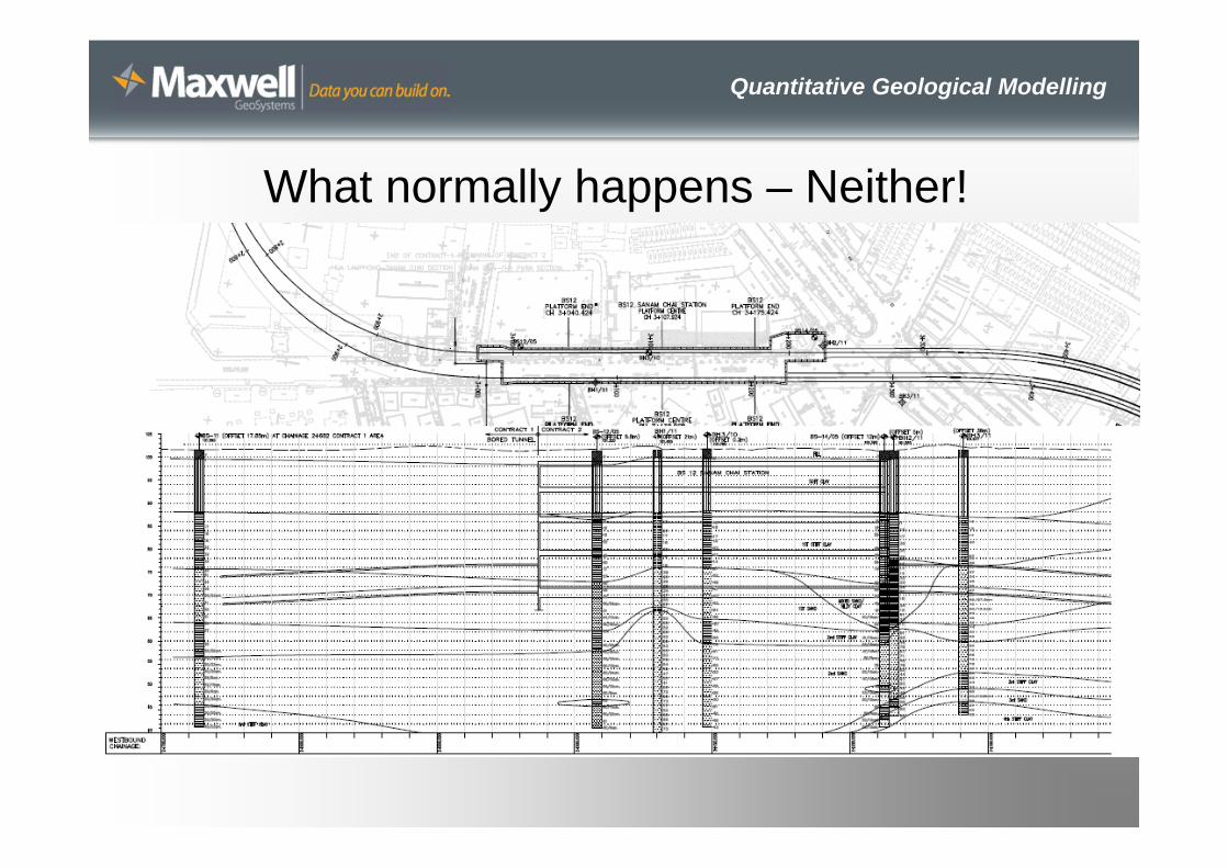
What normally happens – Neither!

Quantitative Geological Modelling
Problems with typical “Join the dots” sections
• Geological input? ………….. Little• Statistical relevance? ………... None• Confidence? …………………. Not quantified• Aliasing ………………………… Unavoidable
??
? ?

Quantitative Geological Modelling
Problems with typical “Join the dots” sections
• Geological input? ………….. Little• Statistical relevance? ………... None• Confidence? …………………. Not quantified• Aliasing ………………………… Unavoidable
Quantitative Geological Modelling
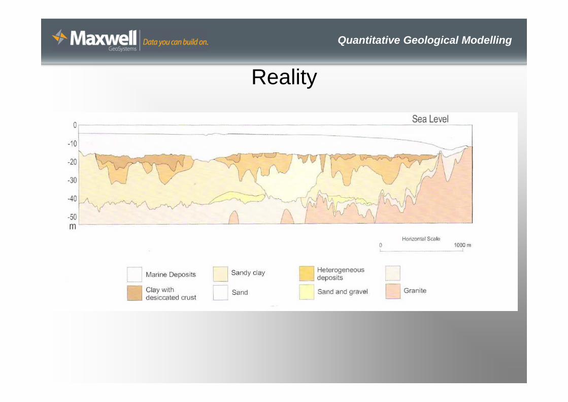
Reality

Quantitative Geological Modelling
What do we need?
• A defendable geological interpretation that is:– True to the data– Geologically sensible– Allows confidence, uncertainty and error to be
quantified– Allows the user to choose the risk profile he/she
wishes to adopt
= GEOSTATISTICS
Quantitative Geological Modelling
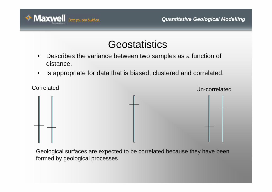
Geostatistics• Describes the variance between two samples as a function of
distance.• Is appropriate for data that is biased, clustered and correlated.
Correlated Un-correlated
Geological surfaces are expected to be correlated because they have been formed by geological processes

Quantitative Geological Modelling
Why do we need it?
• Quantitative models have application in:– Geotechnical baseline reports– Commercial project ground risk evaluation– Insurance ground risk evaluation– Assessment of ground related claims– Assessment of sufficiency of ground investigations– Planning of equipment and methods

Quantitative Geological Modelling
How do we do it?• Exploratory data analysis
– Confirm that the data can be analysed by geostats.– Identify trends– Understand variations
• Variography• Estimation
– Kriging– Co-Kriging– Confidence, error and reliability

Quantitative Geological Modelling
Exploratory Data Analysis
• Geological phenomena have the characteristics of continuous random variables
• Represented by probability distribution functions (normal, log normal)
• From these we can examine:– Central tendency (Mean, Mode, Median)– Spread (Variance, standard deviation)– Shape (Skewness)

Quantitative Geological Modelling
Test suitability for Geostatistics• Test that the data is symmetrical about a mean
Normal (Gaussian Distribution)
Normal Probability Plot (symmetrical)
Probability Plot showing data skewed (non-symmetrical)
Interval
No.
Rank
Valu
e
Rank
Valu
e
Quantitative Geological Modelling
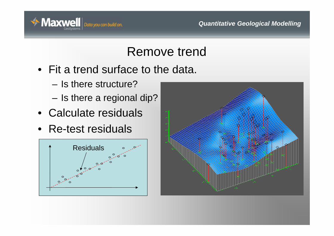
Remove trend• Fit a trend surface to the data.
– Is there structure?– Is there a regional dip?
• Calculate residuals• Re-test residuals
Residuals

Quantitative Geological Modelling
Experimental Variography• Measures spatial
correlation• Models differences
between measured values as a factor of distance
• Usually differences increase as separation increase
Range
Sill
Nugget
DistanceSe
mi-V
aria
nce
Quantitative Geological Modelling
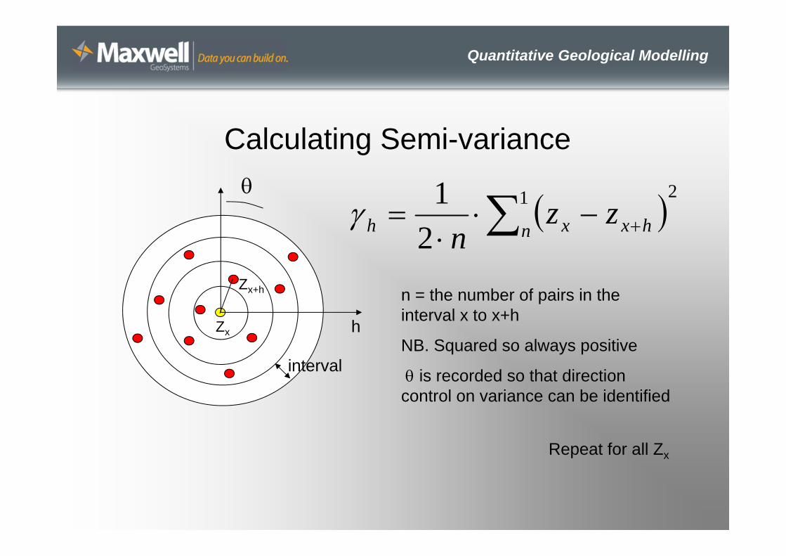
Calculating Semi-variance
interval
Zx
Zx+h
21
21
n hxxh zz
n
n = the number of pairs in the interval x to x+h
NB. Squared so always positive
is recorded so that direction control on variance can be identified
Repeat for all Zx
h

Quantitative Geological Modelling
Result = Omni-directional semi-variogram
Distance
Sem
i-Var
ianc
e
Distance
Sem
i-Var
ianc
e
Distance Distance
Sem
i-Var
ianc
e
Sem
i-Var
ianc
e
Spherical
Hole
Trend
Pure Nugget
Quantitative Geological Modelling
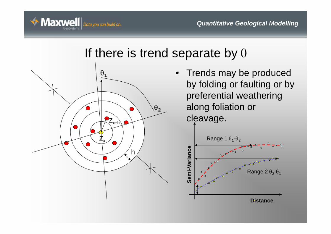
If there is trend separate by • Trends may be produced
by folding or faulting or by preferential weathering along foliation or cleavage.
h
Zx
Zx+h
1
2
Range 1 1-2
Distance
Sem
i-Var
ianc
e
Range 2 2-1

Quantitative Geological Modelling
Estimation
• Variography identifies a set of weights that defines how a parameter can be expected to vary between neighbours.
• Estimation is then done by linear regression to minimise the variance between points.
• Termed Kriging – after South African Mining Engineer - Danny Krige who was
looking for a better way to estimate gold reserves from point samples. He found that averaging methods such as nearest neighbour tended to over estimate reserves.

Quantitative Geological Modelling
Point Kriging
Z1 Z2
Z3
Z4Z5
Z0
n
i ii zwZ1
*0
Where:
Z0* = Estimated (kriged) value at x0
Zi = Measured value at xi
Wi = Estimation (Kriging) weight of Zi derived from the variogram analysis

Quantitative Geological Modelling
Point Kriging: Danny’s Gold
Z1 Z2
Z3
Z4Z5
Z0
n
i ii zwZ1
*0
A
A’
High value
A A’
Over estimates

Quantitative Geological Modelling
Don’t forget to add the trend back in here!
Quantitative Geological Modelling
Benefits of Kriging• Unbiased• Minimum variance• We have a Kriging Standard Deviation (taken
from the variogram)• Automatic declustering of data
– In averaging methods eg. Nearest neighbour clusters have a higher effect on the value at an estimated point. Not so in kriging.

Quantitative Geological Modelling
Benefits of Kriging• Because the Kriging Standard
Deviation for each distance class falls straight from the Variogram we can use this to draw a defendable Upper and Lower confidence limit.
95% UCL
95% LCL
0*00 KSDtZZ
Neat rules:
75% of any population fall within 2 SD of the mean
95% of any population with a normal distribution fall within 2 SD of the mean

Quantitative Geological Modelling
Examples
95% UCL
95% LCL
Tunnel
95% UCL
95% LCL
Excavation or Foundation
Use UCL for 95% chance of avoiding rock or..
LCL for converse
Use UCL for 95% confidence in rock volumes.
Quantitative Geological Modelling
Reliability• How accurate is my model?• Remove each known point in turn and estimate its value
from the model.• Resulting cross validation highlights areas where
samples are anomalous (sampling error, mis-identification, core stones etc)
• Plot Standard Error Maps (standard deviation of the variance). Where the standard error is greater than the sample standard deviation then the estimation is unreliable. More data may be needed.

Quantitative Geological Modelling
Does this make the Geologist Redundant in favour of the statistician?
95% UCL
95% LCL
No. The best estimate may not be the right estimate.
Between the UCL and LCL any interpretation can be drawn eg..

Quantitative Geological Modelling
Conclusions• Quantitative modelling of geological phenomenon is
possible in 2D and in 3D.• Modelling methodology focuses on spatial variance.• Estimation is based on weights derived from model(s) of
spatial variance.• The process provides statistics which can help the
decision process:– Confidence/Uncertainty, Reliability, Significance
• Interpretations can be geologically sensible anddefendable

Quantitative Geological Modelling
Further Resources
• Isobel Clark – Practical Geostatisticshttp://www.kriging.com/pg1979_download.html
• What the heck is a semi variogram?http://www.youtube.com/watch?v=SJLDlasDLEU
• Register for the course in Practical Geostatistics using MissionOS in December

Quantitative Geological Modelling
Thankyou