theme three: the colonial landscape - urban and …
TRANSCRIPT

50
THEME THREE: THE COLONIAL LANDSCAPE - URBAN AND RURAL COMMUNITIES
THE COLONIAL LANDSCAPE - URBAN AND RURAL COMMUNITIES
Roger Leech and Bruce Williams with Nigel Fradgley The research programme, which started in 2000, was directed at the historical archaeology of both urban and rural aspects of the colonial landscape. Work in 2001 was focussed more on the archaeology of rural plantations, with the commencement of a three-year research project centred on the landscape of Mountravers, now supported by the British Academy and the Society of Antiquaries. The work in 2001 also included the completion of excavations within the historic town of Charlestown and ‘rescue archaeology’ work at Jamestown, taking advantage of the opportunities occasioned by drought and the widening of the road on the west side of the island between Charlestown and the Airport. In being able to undertake this work we again owe much to the people of Nevis, and to our colleagues and friends, on Nevis, in North America and in Europe. We acknowledge this help with gratitude more fully at the end of this section of the interim report. The Mountravers Project The Mountravers Project forms part of a wider research programme supported by the British Academy as ‘a pilot project for the historical archaeology of the Atlantic rim’. Looking at the two best documented historic estates on Nevis and St Kitts, the aim of the project is to reconstruct the colonial landscape of the two islands from the sea to the mountain. On Nevis the estate chosen for investigation is Mountravers. On St Kitts the British Academy supported project is investigating the landscape of Wingfield and Romney; the work here is being undertaken by the University of Bristol, in close collaboration with the work of the Nevis Heritage Project at Mountravers. Using the field evidence in conjunction with documentary sources the project as a whole hopes to transform current understanding of the seventeenth-century English colonisation of the Leeward Islands. Mountravers House In 2001 Nigel Fradgley of English Heritage continued his recording and survey of the standing remains of Mountravers House. A fuller draft account of current ideas and understanding of the house is included here as Appendix 1. The main upstanding part of the ruins, the north wing, is now thought to be of the early nineteenth century. This house is likely to have been built by the Huggins family, after the sale of Mountravers by the Pinneys in 1808/9. Architectural and archaeological survey of the much more fragmentary remains of the main eighteenth century house has continued (see Theme Four for the processing of material from the 1998 excavations at Mountravers by Time Team). Archaeological data points to this house having been built in the early eighteenth century. Documentary sources indicate that it was probably built for Azariah Pinney. Analysis of the standing remains and four nineteenth-century photographs indicates that the house was of two storeys, two rooms wide and one room deep, with a cellar below. Its principal axis was north-south, along the contour. The cellar was evidently unlit, built in stone, and probably used principally for wine storage (see Appendix).

51
Fig. 3.1 Mountravers House, areas now examined by excavation
The archaeological excavations commenced in 2001 can be seen as a continuation of the work commenced by Channel 4 Time Team archaeologists in 1998 (Fig. 3.1). The material from these excavations is being reported on by the Nevis Heritage Project. Study of the data from Time Team Trench 2 has pointed to the potential of further excavations below the brick floor of the early eighteenth century house. Detailed archaeological survey of the brick floor of the north part of the cellar (B.1 on Fig. 3.2) revealed the mortar footings for internal bin brick-built divisions, similar to those constructed in cellars in Bristol of the earlier eighteenth century (Figs. 3.2 & 3.3).

52
Wall 734
Disturbance
Paving 709
TIME TEAM TRENCH 2
Brick floor 707
Bin division 711
.5 0 5 Metres
2.5 0 5 10 15 Feet
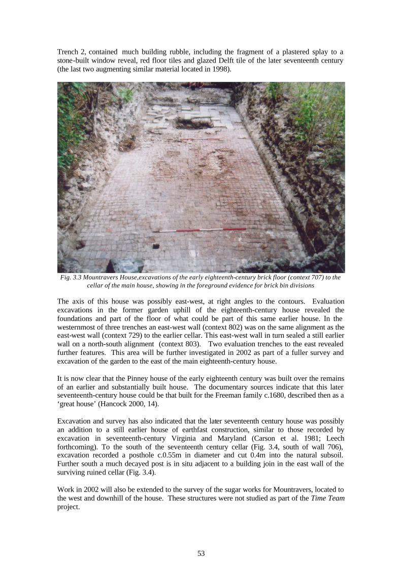
Fig. 3.2 Mountravers House, plan of the early eighteenth-century brick floor (context 707) to the cellar of
the main house Excavation within the cellar of the earlier eighteenth century house was commenced, extending the area first examined by Time Team in 1998. Beneath the brick and stone floor of the eighteenth century was the lower part of the cellar of a house of the later seventeenth century. The north wall of this cellar (context 729) was a revetment of the subsoil, with only an interior face (Figs. 3.4 & 3.3). The south wall of the cellar has not yet been identified. It must lie immediately to the south of the surviving ruined wall (context 706). The fill of the cellar (principally context 736), a small part of which had been removed in 1998 as the Time Team
53
Trench 2, contained much building rubble, including the fragment of a plastered splay to a stone-built window reveal, red floor tiles and glazed Delft tile of the later seventeenth century (the last two augmenting similar material located in 1998).
Fig. 3.3 Mountravers House,excavations of the early eighteenth-century brick floor (context 707) to the
cellar of the main house, showing in the foreground evidence for brick bin divisions The axis of this house was possibly east-west, at right angles to the contours. Evaluation excavations in the former garden uphill of the eighteenth-century house revealed the foundations and part of the floor of what could be part of this same earlier house. In the westernmost of three trenches an east-west wall (context 802) was on the same alignment as the east-west wall (context 729) to the earlier cellar. This east-west wall in turn sealed a still earlier wall on a north-south alignment (context 803). Two evaluation trenches to the east revealed further features. This area will be further investigated in 2002 as part of a fuller survey and excavation of the garden to the east of the main eighteenth-century house. It is now clear that the Pinney house of the early eighteenth century was built over the remains of an earlier and substantially built house. The documentary sources indicate that this later seventeenth-century house could be that built for the Freeman family c.1680, described then as a ‘great house’ (Hancock 2000, 14). Excavation and survey has also indicated that the later seventeenth century house was possibly an addition to a still earlier house of earthfast construction, similar to those recorded by excavation in seventeenth-century Virginia and Maryland (Carson et al. 1981; Leech forthcoming). To the south of the seventeenth century cellar (Fig. 3.4, south of wall 706), excavation recorded a posthole c.0.55m in diameter and cut 0.4m into the natural subsoil. Further south a much decayed post is in situ adjacent to a building join in the east wall of the surviving ruined cellar (Fig. 3.4). Work in 2002 will also be extended to the survey of the sugar works for Mountravers, located to the west and downhill of the house. These structures were not studied as part of the Time Team project.

54
2.5 0 5 10 15 Feet
.5 0 5 Metres
Wall 802Wall 803
Wall 729
Time Team Trench 3
Fill 736
Wall 706
Post hole 739
Wall 734
Fig. 3.4 Mountravers House, excavations of the late seventeenth-century house
Mountravers – The Slave Village Survey of the western part of the slave village site was completed, followed by a series of evaluative excavations of the two stone structures and what was initially identified as a further
55
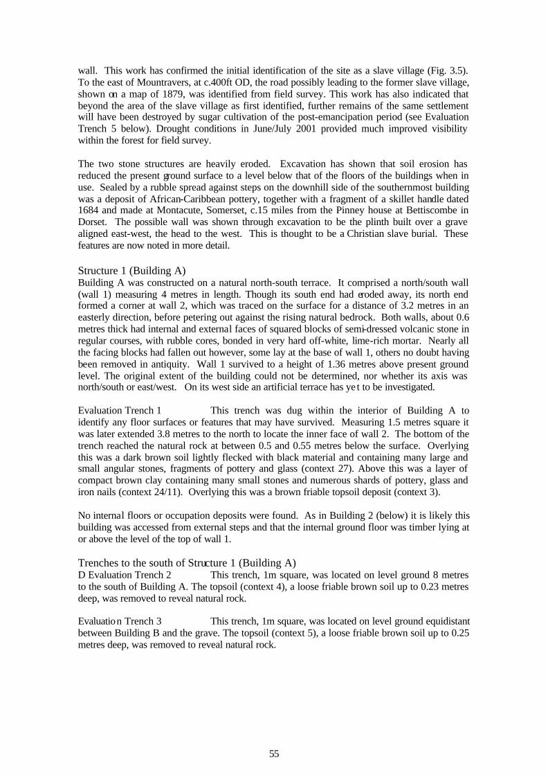
wall. This work has confirmed the initial identification of the site as a slave village (Fig. 3.5). To the east of Mountravers, at c.400ft OD, the road possibly leading to the former slave village, shown on a map of 1879, was identified from field survey. This work has also indicated that beyond the area of the slave village as first identified, further remains of the same settlement will have been destroyed by sugar cultivation of the post-emancipation period (see Evaluation Trench 5 below). Drought conditions in June/July 2001 provided much improved visibility within the forest for field survey. The two stone structures are heavily eroded. Excavation has shown that soil erosion has reduced the present ground surface to a level below that of the floors of the buildings when in use. Sealed by a rubble spread against steps on the downhill side of the southernmost building was a deposit of African-Caribbean pottery, together with a fragment of a skillet handle dated 1684 and made at Montacute, Somerset, c.15 miles from the Pinney house at Bettiscombe in Dorset. The possible wall was shown through excavation to be the plinth built over a grave aligned east-west, the head to the west. This is thought to be a Christian slave burial. These features are now noted in more detail. Structure 1 (Building A) Building A was constructed on a natural north-south terrace. It comprised a north/south wall (wall 1) measuring 4 metres in length. Though its south end had eroded away, its north end formed a corner at wall 2, which was traced on the surface for a distance of 3.2 metres in an easterly direction, before petering out against the rising natural bedrock. Both walls, about 0.6 metres thick had internal and external faces of squared blocks of semi-dressed volcanic stone in regular courses, with rubble cores, bonded in very hard off-white, lime-rich mortar. Nearly all the facing blocks had fallen out however, some lay at the base of wall 1, others no doubt having been removed in antiquity. Wall 1 survived to a height of 1.36 metres above present ground level. The original extent of the building could not be determined, nor whether its axis was north/south or east/west. On its west side an artificial terrace has ye t to be investigated. Evaluation Trench 1 This trench was dug within the interior of Building A to identify any floor surfaces or features that may have survived. Measuring 1.5 metres square it was later extended 3.8 metres to the north to locate the inner face of wall 2. The bottom of the trench reached the natural rock at between 0.5 and 0.55 metres below the surface. Overlying this was a dark brown soil lightly flecked with black material and containing many large and small angular stones, fragments of pottery and glass (context 27). Above this was a layer of compact brown clay containing many small stones and numerous shards of pottery, glass and iron nails (context 24/11). Overlying this was a brown friable topsoil deposit (context 3). No internal floors or occupation deposits were found. As in Building 2 (below) it is likely this building was accessed from external steps and that the internal ground floor was timber lying at or above the level of the top of wall 1. Trenches to the south of Structure 1 (Building A) D Evaluation Trench 2 This trench, 1m square, was located on level ground 8 metres to the south of Building A. The topsoil (context 4), a loose friable brown soil up to 0.23 metres deep, was removed to reveal natural rock. Evaluation Trench 3 This trench, 1m square, was located on level ground equidistant between Building B and the grave. The topsoil (context 5), a loose friable brown soil up to 0.25 metres deep, was removed to reveal natural rock.

56
Grave
limit of excavat ion
10 0 10 20
2 0
30 Feet
10 Metres
Building BSteps
Wall
Wall foundation trench?
Building A
Wall 1
Wall 2
Limit of excavation
Slab or waterhole
35 0 Feet340 Feet
Fig. 3.5 Mountravers Slave Village, areas now examined by excavation
Structure 2 (Building B) Building B was c.7 metres to the south-east of Building A and was defined by a raised area of stone standing at least 2.5 metres above the immediate area to the west. What at first appeared to be the possible remains of an attached oven (context 13) are now interpreted as steps built

57
against a north/south wall (context 12). The original treads to the steps had been removed revealing a cavity within the core of the structure. The remains of three risers survived on the steps, leading upwards to Building B on the east, defined on its west side by a wall (context 12) and on its north, east and south by rubble spreads (context 14). The sides to the steps and wall were faced in squared, semi-dressed blocks of masonry, as used for Building 1, and were similarly bonded in a very hard off-white mortar. The core of the steps however was built using masonry and bricks, though none was complete. What was significant about the steps and wall was ribbon pointing between the stones. This form of pointing leaves the mortar standing proud of the wall, and is generally not seen on buildings in England until well into the twentieth century. On Nevis however, identical pointing, apparently original, can still be seen on Cottle Church at the north end of the island, which dates from the 1820s. No other walls to this building were visible on the surface within the rubble spread (context 14) and it became apparent that the west wall (context 12) had survived only because the steps had acted as a buttress and barrier against collapse and erosion. Evaluation Trench 4 A trench 5.6 metres by about 1.5 metres abutted the south face of the steps, and was aligned east/west so as to examine in section the end of wall 12, the adjacent rubble mound and any surviving internal floors, and external deposits against the steps.
Fig. 3.6 Mountravers Slave Village: the grave in the course of excavation
At its east end the natural rock lay no more than 0.1m below the surface, but this became progressively deeper towards the west until, adjacent to the west wall (12), the rock was 1.2m down. The steps and wall had been founded over a thin smothering of lime-rich mortar placed on the natural rock. The rock where exposed was sloping and deeply fissured. Within the fissures survived a fine compact stone-free silty soil (context 34). Above this was an occupation deposit of fine black, loose crumbly soil, heavily flecked with charcoal, with Afro-Caribbean pottery and European whitewares, clay tobacco pipes and animal bones. Above this and above the layer 34, sealed by the topsoil (context 21) was a layer of fine, crumbly brown soil and rubble up to 0.8 metres deep (context 14), which included lumps of mortar and the end of a handle from a brass skillet. The skillet handle is of some interest. It carries the letters ‘HE PORE’ and the date ‘1684’. The full inscription would have read ‘PITY THE PORE’. Skillets bearing the same inscription and date were made by the foundry of John Fathers of Montacute in Somerset, c.15 miles from Bettiscombe, the Dorset home of the Pinney family (Everleigh

58
1993-4, 12-17). The context of the skillet handle within the slave village will merit further discussion. The Grave A grave (Fig. 3.6) was located on slightly sloping ground c.15 metres to the south-west of Building B. The kerb of the grave (context 15), an east/west line of four semi-dressed stones, was initially thought to be a wall, identified as such by David Small with Roger Leech in 2000. Removal of the topsoil (context 25) from the south side of the kerb revealed a larger stone at each end of the feature, and further stones, though much smaller and randomly placed, covering an area 2.2 metres east/west by 1.0 metre across. These stones sealed a surface of flatter, amorphous stones (context 28) about 0.45 metres below the level of the kerb. At the west end of the feature a compact dark brown soil 0.5 metres in depth (context 28) overlay an articulated burial, aligned east-west, head to the west. The grave was back-filled. Evaluation Trench 5 Some 25 metres east of Building B field survey located a cultivation terrace extending for at least 60 metres north-south. An evaluation trench 1 metre square provided a record of c.0.5 metres of deposits above the natural subsoil. Sealing the subsoil was a compact dark brown quite stony soil (context 32), c.0.2 metres in depth, with pottery, glass and clay tobacco pipe. This was thought to be a former sugar cultivation soil. The Landscape of Mountravers - Field Survey The fields of Mountravers Uphill of Mountravers field survey has confirmed the accuracy of the 1879 map of the estate. Running along the contour at c.650ft OD a massive boundary wall is likely to have been the former boundary between Mountravers and Woodlands, before the acquisition of the Woodlands estate by John Pinney in 1778. Survey in 2002 will continue the field survey of this and other field walls recorded in 2001 (Fig. 3.7). The Woodlands estate The 1879 map of Mountravers shows no field boundaries within the estate above the massive boundary wall at c.650ft OD. Field survey has shown that there were once a number of such boundaries, subdividing the estate known as Woodlands into a series of at least three and possibly as many as six separate fields (Fig. 3.7). Within this area survey has also revealed two distinct settlement nuclei, indicating that Woodlands itself may formerly have consisted of two separate smaller plantations. The Woodlands plantation house and works The earthwork and standing remains of a plantation house and works, first identified in 2000, are located c.1km to the east of Mountravers House, at c.900ft OD. Detailed survey of 90% of this site was completed (Fig. 3.8). East of and above the house steps led to a garden area yet to be examined. The house (A on Fig. 3.8) occupied a position of surveillance, overlooking the works. It was of one room in depth with insubstantial stone walls, probably the foundation for a timber framed structure above. On the west side was a centrally placed projecting porch. To the south-west of the house steps descended to the cattle mill (B) and adjacent boiling house (C). The complex and attendant yards stood within a large enclosure, with ‘slabs’ or water holes on the north and south. The Woodlands slave village The slave village of the Woodlands plantation is probably located c.200m to the south, on the same contour level as the works (see fig. 3.7). Here there are numerous terrace walls and possible platforms extending over an area c.200m square. Detailed survey of this site will be undertaken in 2002.