this document has been published by the western australian ... · pdf filecase may be, in...
TRANSCRIPT


This document has been published by the Western Australian Planning Commission. Any
representation, statement, opinion or advice expressed or implied in this publication is made in good faith and on the basis that the Government,
its employees and agents are not liable for any damage or loss whatsoever which may occur
as a result of action taken or not taken, as the case may be, in respect of any representation,
statement, opinion or advice referred to herein. Professional advice should be obtained before
applying the information contained in this document to particular circumstances.
website: www.planning.wa.gov.auemail: [email protected]: 08 6551 9000fax: 08 6551 9001National Relay Service: 13 36 77infoline: 1800 626 477
Department of Planning owns all photography in this document unless otherwise stated.
This document is available in alternative formats on application to Communication Services.
© State of Western Australia
Published by theWestern Australian Planning Commission
Gordon Stephenson House140 William StreetPerth WA 6000
Locked Bag 2506Perth WA 6001
Published September 2015

Letter of transmittal
Hon John Day MLAMinister for PlanningCulture and the ArtsLeader of the House
In accordance with Section 61 of the Financial Management Act 2006, I submit for your information and presentation to Parliament, the Annual Report of the Western Australian Planning Commission for the year ended 30 June 2015.
The Annual Report has been prepared in accordance with the provisions of the Financial Management Act 2006 and any other relevant written law.
Eric Lumsden PSMChairmanWestern Australian Planning Commission
22 September 2015
This annual report covers the operations of the Western
Australian Planning Commission. The report also presents a series of audited financial statements and performance indicators for the year ended 30 June 2015.

Where to find usWestern Australian Planning CommissionGordon Stephenson House140 William StreetPerth WA 6000
Phone: +61 8 6551 9000Fax: +61 8 6551 9001Website: www.planning.wa.gov.auEmail: [email protected]
Governance and other disclosures 27
Ministerial directives 27Governance 27Strategic Plan 27Board Charter 28Planning reforms 28LPS Regulations 282015 Client Satisfaction Survey 29Internal audit 29External audit 30Probity 30
Advertising and marketing expenditure 30
Major capital projects 30
appendices 311. Western Australian Planning
Commission members (as at 30 June 2015) 31
2 Western Australian Planning Commission, committees and sitting fees 36
3 Remuneration for committee members 37
financials & KPIs 38Auditor General Independent Auditor’s Report
Financial Statements
Key Performance Indicators
Commission services 10
SERVICE 1 STATUTORY PLANNING 10
Transport Route Planning 15
SERVICE 2 STRATEGIC PLANNING 16
Growing the Regions 20
SERVICE 3 ASSET MANAGEMENT 23
Property acquisition 23Roads 23Railways 23Bush Forever 23Parks and Recreation (regional open space) 24River and ocean foreshores 24Regional parks 24Property Disposals 24Whiteman Park 25
Capital Works 25Park and Community Projects 25
Hester Park 26
Executive summary 2
Significant issues and trends 4
2014/15 snapshot 5
About the Commission 6Enabling legislation 6Responsible Minister 6Legislation administered 6Stakeholders 6Shared responsibilities with other agencies 6
The planning context 7
Report on operations 8Performance management framework 8The Planning Program 2014/15 9
Overarching Ministerial objectives 9
The title block, as per below, on each page operates as a link back to the contents

The planning and infrastructure frameworks for each of the eight country planning regions – Kimberley, Pilbara, Gascoyne, Mid-West, Goldfields-Esperance, Wheatbelt, South-West and Great Southern – are well placed to inform and guide decision-making across the State. The frameworks define a strategic vision and direction for the regions, and provide an overview of regional planning issues, priorities and initiatives to promote economic development and associated infrastructure priorities. Importantly, they are a key component of a whole-of-government endeavour to provide aligned and integrated delivery of services across regional Western Australia.
In addition, initiatives such as the Dampier Peninsula Planning Strategy, the Coral Bay Settlement Structure Plan and ongoing implementation of the Pilbara Cities vision and the Greater Bunbury Urban and Industrial expansion areas are indicative of the varied range of operations and activities that are contributing to regional growth and prosperity.
Progress has been made in the development of contemporary, transparent and accountable processes for both the Commission board and its associated statutory and regional committees.
A tangible outcome of this work has been the development of the Commission’s four-year Strategic Plan and Board Charter. The Strategic Plan, with a vision to ‘shape the future of Western Australia’ positions the Commission
The draft planning frameworks have considered all aspects – land use, economy and employment, community and social infrastructure, the movement network and protection of the environment - to accommodate a substantial population increase reaching 3.5 million people over the next 35 years. This will be achieved within a connected city growth pattern while preserving important environmental assets and maintaining Western Australia’s highly-valued lifestyle. Substantial work has been undertaken in the development of these considered documents which will be finalised following a public consultation period.
These important proposals are complemented by a range of priority initiatives that will make an important contribution to our population, housing and employment targets identified in Directions 2031 and Beyond and reinforced through Perth and Peel @3.5 million. These include:
� finalising the Burswood Peninsula District Structure Plan;
� preparing a Strategic Planning Framework to support delivery of the State Government’s Forrestfield-Airport Link project; and
� preparing the Stirling Highway Activity Corridor Study.
Substantial work has been carried out towards the future development of regional Western Australia.
The 2014/15 financial year has been another landmark year for the Western Australian Planning Commission, with significant progress made on three key aspects of our work to shape functional, resilient and sustainable Western Australian communities. These overarching imperatives are:
� the future development of Perth and Peel;
� growing the regions; and
� governance reforms.
The future development of the Perth and Peel regions was clearly articulated in the draft Perth and [email protected] suite of strategic land use documents, released in May 2014. I believe these sub-regional planning frameworks have the potential to be as significant for the region as the definitive 1955 Plan for the Metropolitan Region Perth and Fremantle, better known as the Stephenson-Hepburn Plan after its principle authors. That holistic plan was designed to accommodate 1.4 million people by 2005 and provided the basis for the city’s current urban form.
executive summary

as the lead authority delivering the State Planning Strategy’s intent of sustained growth and prosperity. The new Board Charter outlines our obligations and responsibilities and defines how members are expected to undertake and fulfil those obligations.
Eric Lumsden PSMChairmanWestern Australian Planning Commission
These key documents underpin a schedule of ongoing governance reforms to ensure that we are providing accountable and ethical decision-making as well as strategic leadership and direction.
I extend my thanks to the Minister for Planning, the Honourable John Day MLA and all Western Australian Planning Commissioners and board members for their commitment and support throughout the past year. I also acknowledge the significant contribution made by the Director General of the Department of Planning, Gail McGowan and the Department’s Executive Directors and staff towards the successful application of the Commission’s endeavours.

The Western Australian Planning Commission continues to respond to the strategic direction of Government through the following significant initiatives:
� A suite of strategic planning framework documents has been prepared to outline how Perth and Peel can accommodate a population of 3.5 million people over the next 35 years. The documents clearly spell out future land uses through urban consolidation and development of a more considered, connected and consolidated urban form.
� The reform initiatives outlined within the Planning Makes It Happen: Phase Two report progressed. This included preparing new Planning and Development (Local Planning Schemes) Regulations 2014 for an improved process for preparing local planning schemes, the introduction of new risk-based scheme amendment processes and streamlined land use planning and development decisions.
� Land use planning of Airport West and Forrestfield Station Precincts to provide for transit oriented development and land use intensification around the two station sites is underway.
� Improvement Plans and Improvement Schemes for a number of key Strategic Industrial Areas in the Pilbara (at Ashburton North, Anketell, and Maitland) were developed. These aim to define and implement a streamlined and responsive land use planning framework through which to facilitate large-scale resource
projects that are vital to Western Australia’s economy.
� Through the implementation of the regional planning and infrastructure frameworks and supporting Regional Development Blueprints and Growth Plan, the Commission linked planning decision-making with development and investment decision-making.
� The Commission acquired land for rail and other infrastructure corridors to address emerging congestion and infrastructure issues.
� The 2007 Lower Great Southern Strategy was reviewed as part of ensuring a robust and contemporary regional strategic planning framework is in place for the Great Southern region. The framework will provide coordinated consideration of infrastructure, economic, environmental, social and cultural elements in the Lower Great Southern region to guide its growth and development over the next 20 years.
� Work progressed on the extension of the Metropolitan Region Improvement Fund (MRIF) collection to areas where region planning schemes apply. The extension of the Metropolitan Region Improvement Tax (MRIT) will provide assistance for funding injurious affection compensation claims of landowners for acquisition of land reserved for the Peel and Greater Bunbury Region Schemes.
� Land use planning regulations and policies to improve bushfire risk management have
been prepared as recommended by the 2011 Keelty report, A Shared Responsibility.
� In consultation with the City of Belmont, a planning study for land at Ascot including the heritage-listed former Bristile Kilns to was progressed to establish a viable project that appropriately protects and interprets these important heritage structures.
� The Coastal Zone Management program continued to deliver sustainable development outcomes for the coastal zone area.
significant issues and trends
2014/15 snapshot
Perth and [email protected] suite of strategic land use planning documents to accommodate 3.5 million people by 2050 is released for public comment.
Draft Burswood Peninsula district structure plan is released for public comment.
Planning Makes It Happen: Phase Two planning reforms to increase efficiency and effectiveness are introduced.
The latest edition of the Urban Growth Monitor 2014 that provides a definitive report on the urban land supply within Perth, Peel and the Greater Bunbury regions is released.
Draft Local Planning Schemes Regulations, part of a package on planning reforms are released for public comment.
Town of Cottesloe’s new town planning scheme, Local Planning Scheme 3 is finalised.
More than $650,000 is made available through Coastwest grants and the Coastal Management Plan Assistance program to help coast land managers address pressures on coastal land throughout the State.
Six amendments to the Metropolitan Region Scheme are approved to free up employment-generating industrial land at Hazelmere.
Work progressed on two major development areas for the future growth of Greater Bunbury – Wanju, the urban area east of the Eaton town centre, future home to up to 70,000 people and the proposed new Waterloo Industrial Estate.
Regional Planning and Infrastructure Frameworks for Gascoyne and the Mid-West are released.
Changes to the State’s planning system to encourage housing affordability are announced.
Coral Bay Settlement Structure Plan, providing a 25 year planning framework for future development and expansion of tourism is released.
New strategy to shape the future of the Kimberley’s Dampier Peninsula is released.
South Guildford MRS amendment to rezone the former Rosehill golf course site from ‘rural’ to ‘urban’ is approved.
The Western Australian Planning Commission (the Commission) is the statutory body with state-wide responsibility for urban, rural and regional integrated strategic and statutory land-use planning and land development.
In 2014/15, it comprised a Chair and 15 members (see Appendix 1), representing industry, government and the community to respond to the strategic direction of government on urban, rural and regional land use planning as well as other land development matters throughout Western Australia.
The Commission operates with the support of the Department of Planning which provides professional and technical expertise, administrative services and resources to advise and implement the Commission’s decisions.
It is responsible for:
� advising the Minister for Planning on strategic land use planning and land development, legislative reform and local planning schemes;
� making statutory decisions on a range of planning applications;
� implementing the State Planning Strategy to provide a vision for the future development of Western Australia;
� developing integrated land use planning strategies for the coordinated provision of transport and infrastructure for land development;
� preparing and reviewing region schemes to cater for anticipated growth;
� monitoring and forecasting land supply throughout the State and developing strategies for the timely supply of affordable residential land;
� undertaking research and developing planning methods and models relating to land use planning, land development and associated matters; and
� acquiring land for public requirement reservations in region planning schemes and compensating affected landowners.
Enabling legislationThe Commission was established under Section 7 of the Planning and Development Act 2005.
Responsible MinisterIt is responsible to the Minister for Planning; Culture and the Arts, Leader of the House, the Hon John Day BSc BDSc MLA.
Legislation administeredThe Commission exercises the functions and powers given to it under the Planning and Development Act 2005.
It is responsible for and has decision-making functions under the following region planning schemes and processes; and strategic and statutory planning throughout the State:
� Metropolitan Region Scheme
� Peel Region Scheme
� Greater Bunbury Region Scheme.
StakeholdersAs well as the Minister for Planning, the Premier and State Parliament, the Commission works with local governments, property developers, builders and architects, State and Commonwealth Government agencies, environmental groups, community groups and individual land owners and their legal representatives.
Shared responsibilities with other agenciesThe Commission has common interests with a range of authorities including the Environmental Protection Authority, the Heritage Council and the Swan River Trust. It also works to foster relationships with local, State and Commonwealth Government agencies.
about the Commission

The State Planning Strategy 2050 is the leading strategic planning document within Government. Its purpose and function is to provide a credible State strategic context and basis for the integration and coordination of land use planning and development across state, regional and local jurisdictions.
Directions 2031 and Beyond is a high-level spatial framework and strategic plan for future growth for the Perth and Peel regions and guides the detailed planning and delivery of housing, infrastructure and services necessary to accommodate future population growth.
The draft planning frameworks within the Perth and [email protected] builds on the vision of Directions 2031 and Beyond and when finalised as sub-regional structure plans will provide strategic guidance to government agencies and local governments on land use, land supply, land development, environmental protection, infrastructure investment and the delivery of physical and community/social infrastructure across Perth and Peel.
the planning context
FIGURE 1: THE WESTERN AUSTRALIAN PLANNING SYSTEM FRAMEWORK
STATE
LEVEL STRATEGIC STRUCTURE PLANS
STATUTORY POLICY
State Planning Strategy
Directions 2031/ Sub-regional framework/ Sub-regional Structure Plan
State Planning Policy
Strategic/ Operational
Policy
Region Scheme
Local Planning Scheme
Local Planning PolicyDistrict/Local/Activity
Centre Structure Plan
Local Planning Strategy
REGIONAL
LOCAL

Performance management frameworkThe Western Australian Government has five goals that guide the development of policies, programs and services within its agencies. These are:
Goal 1: State building – major projects
Building strategic infrastructure that will create jobs and underpin Western Australia’s long-term economic development.
Goal 2: Financial and economic responsibility
Responsibility for managing the State’s finances through the efficient and effective delivery of services, encouraging economic activity and reducing regulatory burdens on the private sector.
Goal 3: Results-based service delivery
Greater focus on achieving results in key service delivery areas for the benefit of all Western Australians.
Goal 4: Stronger focus on the regions
Greater focus on service delivery, infrastructure investment and economic development to improve the overall quality of life in remote and regional areas.
Goal 5: Social and economic responsibility
Ensuring that economic activity is managed in a socially and environmentally responsible manner for the long-term benefit of the State.
FIGURE 2: WESTERN AUSTRALIAN PLANNING COMMISSION CONTRIBUTION TO STATE GOVERNMENT GOALS
CONTRIBUTION TO GOVERNMENT GOALS
The Western Australian Planning Commission outcomes and services, and contribution to the State Government goals
SERVICE
DESIRED OUTCOME
GOVERNMENT GOAL
Results-based service delivery
Greater focus on achieving results in key service delivery areas for the benefit of all Western Australians
GOAL 3
Integration of land systems that facilitates economic
development
Accessibility to serviced land and infrastructure
SERVICE 1STATUTORY PLANNING
SERVICE 2STRATEGIC PLANNING
SERVICE 3ASSET
MANAGEMENT
report on operations

The Western Australian Planning Commission contributes to all State Government goals and particularly to Goal 1 by delivering land use planning and implementation strategies to guide the State’s long-term urban and economic development through three services:
SERVICE 1 STATUTORY PLANNING
Using statutory, consultative, legislative, regulatory reform and coordination processes to implement creative and innovative strategic regional and local plans and policies.
SERVICE 2 STRATEGIC PLANNING
Developing and advancing strategic and statutory planning strategies, policies and information systems that guide the State’s long-term urban, industrial and economic development and management of the environment to reflect Western Australian aspirations for a high quality of life.
SERVICE 3 ASSET MANAGEMENT
Acquiring, managing and disposing of properties reserved under the Metropolitan, Peel and Greater Bunbury region schemes for primary and other regional roads; parks and recreation and regional open space; special uses including planning control areas and improvement plans; and major land development projects.
The Planning Program 2014/15The Western Australian Planning Commission’s overarching land use planning obligations and correlating outcomes are determined through its Planning Program.
The 2014/15 program was established through close collaboration with the Minister of Planning and the Department of Planning to identify State planning objectives and priorities. These provided the focus and direction for all business areas.
Overarching Ministerial objectives
The Ministerial objectives for 2014/15 were:
� Communicate and implement a collaborative vision for well-managed growth in Perth and Western Australia, through strong strategic planning documents and planning processes that facilitate well-designed development and increased density and diversity in appropriate locations.
� Ongoing reform and improvement of the planning system, to respond to growth and demographic change, streamline planning processes, and to achieve improved outcomes in the physical environment.
� Ensure that the Department’s (of Planning) contribution to land supply continues to keep pace with the economic and population growth of the State (safeguard against future land supply crises).
� Help to make Western Australia a more affordable place to live, through assisting in the delivery of the State’s Housing Affordability Strategy and making effective and efficient planning decisions.
� Coordinate infrastructure planning and provision through integrated planning and stakeholder liaison.
� Continue to provide considered planning advice to the Minister’s office and other stakeholders, and promote the values of transparent decision-making and orderly and proper planning.

During 2014/15, the Western Australian Planning Commission provided three key services – statutory planning, strategic planning and asset management.
SERVICE 1 STATUTORY PLANNING
Metropolitan Region Scheme amendments
A total of 24 amendments were finalised during 2014/15. A further 19 amendments were initiated or are in progress.
MAJOR MINOR OTHERNO AMENDMENT TITLE WEBSITE ADDRESS IN TAB FIN IN FIN IN FIN1228/41 Bellevue Urban Precinct and Surrounds www.planning.wa.gov.au/publications/6832.asp X1239/41 Gidgegannup Urban Precinct www.planning.wa.gov.au/publications/6548.asp X1240/41 South Forrestdale Business Park www.planning.wa.gov.au/publications/6557.asp X1242/41 Lot 911 Midland Road, Hazelmere www.planning.wa.gov.au/publications/6708.asp X1280/41 Mangles Bay Marina www.planning.wa.gov.au/publications/7917.asp X1291/41 Herdsman-Glendalough Precinct No website address X1298/41 West Mundijong Industrial Precinct No website address X1188/57 Wellard Urban Precinct (East) www.planning.wa.gov.au/publications/7168.asp X1227/57 Southern River Road Reservation and Garden Street
Realignmentwww.planning.wa.gov.au/publications/6326.asp X
1251/57 Hazelmere Enterprise Area Structure Plan Precinct 2A and 2B – Helena River Precinct
www.planning.wa.gov.au/publications/6994.asp
X
1252/57 Hazelmere Enterprise Area Structure Plan Precinct 3A and 3B – HEA Buffer Area
X
1253/57 Hazelmere Enterprise Area Structure Plan Precinct 4 – Hazelmere Interface
X
1254/57 Hazelmere Enterprise Area Structure Plan Precinct 7 – HEA South
X
1255/57 Hazelmere Enterprise Area Structure Plan Precinct 8 – HEA South Buffer
X
1256/57 Hazelmere Enterprise Area Structure Plan Precinct 9A – Bushmead
X
1263/57 Lots 89-95 & 100 Dundebar Road and Lot 88 Garden Park Drive, Wanneroo
www.planning.wa.gov.au/publications/7152.asp X
Commission services
TABLE LEGENDIN Initiated in 2014/15 financial yearFIN Finalised in 2014/15 financial yearTAB Tabled in parliament in 2014/15 financial year
NOTESLifting of Urban Deferred outside MRS are indicated by /13Lifting of Urban Deferred within MRS are indicated by /27PCA represents Planning Control AreaIP represents Improvement Plan

MAJOR MINOR OTHERNO AMENDMENT TITLE WEBSITE ADDRESS IN TAB FIN IN FIN IN FIN1266/57 Rosehill Golf Course Redevelopment www.planning.wa.gov.au/publications/7108.asp X1274/57 Balannup/Skeet Road Precinct, Harrisdale www.planning.wa.gov.au/publications/7177.asp X X1278/57 Rockingham Strategic Regional Centre www.planning.wa.gov.au/publications/7633.asp X1282/57 Forrestfield-High Wycombe Precinct 3 www.planning.wa.gov.au/publications/7841.asp X1283/57 Holmes Street Reservation, Southern River www.planning.wa.gov.au/publications/7815.asp X1284/57 Lots 5000 and 5001 Pipidinny Road, Eglinton www.planning.wa.gov.au/publications/7811.asp X1286/57 Western Power Omnibus 1 www.planning.wa.gov.au/publications/7943.asp X1287/57 Lake Road, Champion Lakes www.planning.wa.gov.au/publications/7845.asp X1288/57 Lots 986 and 993 Baldivis Road, Baldivis www.planning.wa.gov.au/publications/7849.asp X1289/57 Lot 821 Armadale Road, Banjup and Surrounds Not yet released X1290/57 Anstey, Armadale and Keane Roads, Forrestdale Precinct Not yet released X1292/57 North East and North West Districts Omnibus 1 Not yet released X1293/57 Shenton Park Hospital Redevelopment www.planning.wa.gov.au/publications/7882.asp X1297/57 South East and South West Districts Omnibus 2 Not yet released X1300/57 Maddington-Kenwick Strategic Employment Area
– Welshpool Road East Industrial PrecinctNot yet released X
1301/57 Maddington-Kenwick Strategic Employment Area Precinct 2 Not yet released X1302/57 Maddington-Kenwick Strategic Employment Area Precincts
3A and 3BNot yet released X
1261/27 Lots 459-461, Pt Lots 462 and 463 Baldivis Road and portion of Pug Road, Baldivis (Modification)
www.planning.wa.gov.au/publications/6927.asp X
1279/27 Portion of the Upper Swan Urban Precinct www.planning.wa.gov.au/publications/7298.asp X1281/27 Southern River Precinct 3A (North) No website address X1294/27 Pt Lots 510, 515 and 516 Sabrina, Baldivis and Bodman Roads,
BaldivisNo website address X
1295/27 South Fremantle Power Station No website address X1296/27 Wellard Urban Precinct (East) No website address X1299/27 Shenton Park Hospital Site No website address XPCA 114 Lot 515 Sabrina Road, Baldivis www.planning.wa.gov.au/publications/7617.asp XIP 39 Lissiman Street Precinct www.planning.wa.gov.au/publications/7283.asp X
TABLE LEGENDIN Initiated in 2014/15 financial yearFIN Finalised in 2014/15 financial yearTAB Tabled in parliament in 2014/15 financial year
NOTESLifting of Urban Deferred outside MRS are indicated by /13Lifting of Urban Deferred within MRS are indicated by /27PCA represents Planning Control AreaIP represents Improvement Plan

Peel Region Scheme amendments
A total of two amendments were finalised during 2014/15. A further two amendments were initiated or are in progress.
MAJOR MINOR OTHERNO AMENDMENT TITLE WEBSITE ADDRESS IN TAB FIN IN FIN IN FIN027/13 Lot 803 North Yunderup Road www.planning.wa.gov.au/publications/7311.asp X038/57 McLarty Explosives Reserve www.planning.wa.gov.au/publications/7286.asp X X039/57 Lakelands North www.planning.wa.gov.au/publications/7861.asp X
Greater Bunbury Region Scheme amendments
A total of four amendments were finalised during 2014/15. A further five major amendments were initiated or are in progress.
MAJOR MINOR OTHERNO AMENDMENT TITLE WEBSITE ADDRESS IN TAB FIN IN FIN IN FIN0028/57* Part Lot 301 Boyanup-Picton Road, Picton East Not yet released0030/57* Lot 9001 Waterloo Road, Roelands www.planning.wa.gov.au/publications/6808.asp0033/57 Omnibus No. 3 - Anomalies www.planning.wa.gov.au/publications/7126.asp X0035/57 McLarty Explosives Reserve Facility www.planning.wa.gov.au/publications/7286.asp X X0038/57 Western Power Omnibus No. 1 www.planning.wa.gov.au/publications/7780.asp X0039/57 Bunbury Airport Expansion www.planning.wa.gov.au/publications/7889.asp X0036/13 South East Capel Local Structure Plan area No website listing X X0037/13 Lot 1 Leisure Drive, Australind No website listing X X
*0028/57 initiated in 2012/13. Issues being resolved.*0030/57 initiated In 2012/13. Issues being resolved.
TABLE LEGENDIN Initiated in 2014/15 financial yearFIN Finalised in 2014/15 financial yearTAB Tabled in parliament in 2014/15 financial year
NOTESLifting of Urban Deferred outside MRS are indicated by /13Lifting of Urban Deferred within MRS are indicated by /27PCA represents Planning Control AreaIP represents Improvement Plan
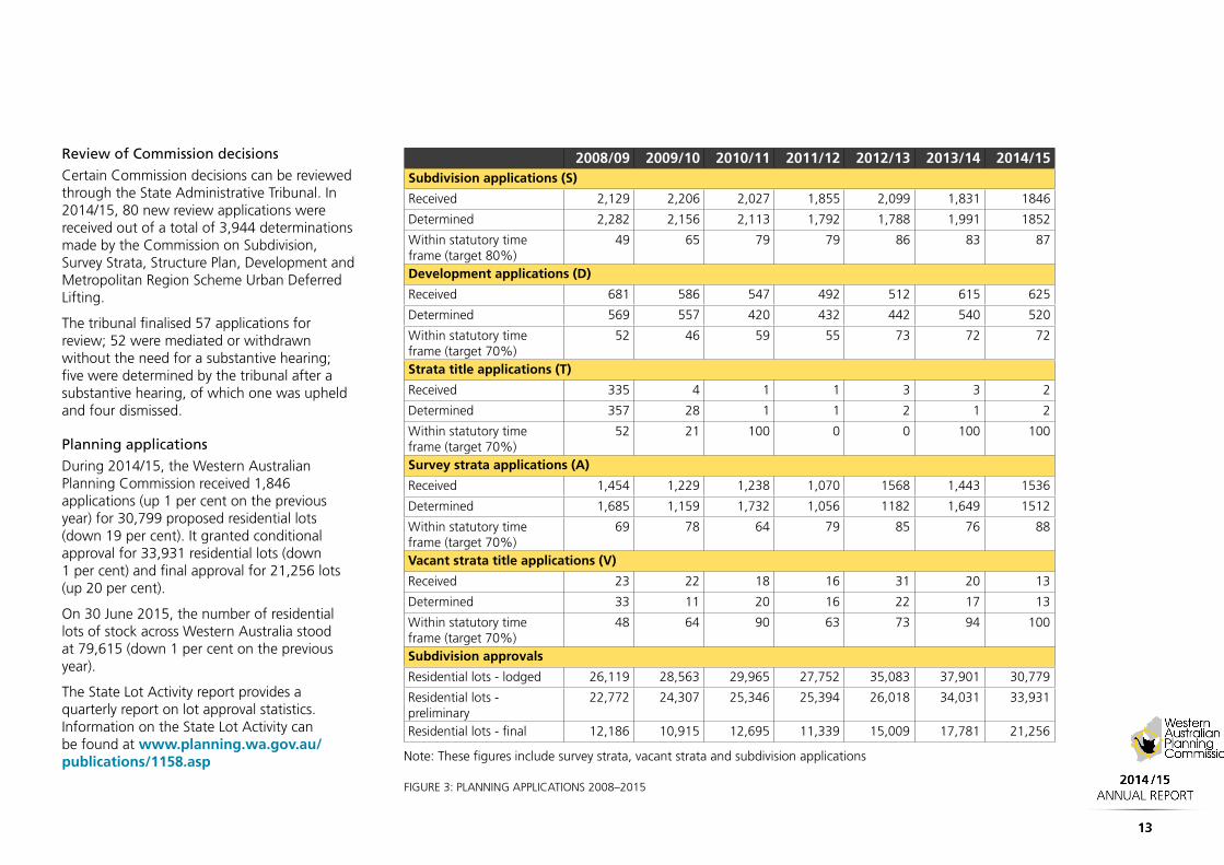
Review of Commission decisions
Certain Commission decisions can be reviewed through the State Administrative Tribunal. In 2014/15, 80 new review applications were received out of a total of 3,944 determinations made by the Commission on Subdivision, Survey Strata, Structure Plan, Development and Metropolitan Region Scheme Urban Deferred Lifting.
The tribunal finalised 57 applications for review; 52 were mediated or withdrawn without the need for a substantive hearing; five were determined by the tribunal after a substantive hearing, of which one was upheld and four dismissed.
Planning applications
During 2014/15, the Western Australian Planning Commission received 1,846 applications (up 1 per cent on the previous year) for 30,799 proposed residential lots (down 19 per cent). It granted conditional approval for 33,931 residential lots (down 1 per cent) and final approval for 21,256 lots (up 20 per cent).
On 30 June 2015, the number of residential lots of stock across Western Australia stood at 79,615 (down 1 per cent on the previous year).
The State Lot Activity report provides a quarterly report on lot approval statistics. Information on the State Lot Activity can be found at www.planning.wa.gov.au/publications/1158.asp
2008/09 2009/10 2010/11 2011/12 2012/13 2013/14 2014/15Subdivision applications (S)
Received 2,129 2,206 2,027 1,855 2,099 1,831 1846
Determined 2,282 2,156 2,113 1,792 1,788 1,991 1852
Within statutory time frame (target 80%)
49 65 79 79 86 83 87
Development applications (D)
Received 681 586 547 492 512 615 625
Determined 569 557 420 432 442 540 520
Within statutory time frame (target 70%)
52 46 59 55 73 72 72
Strata title applications (T)
Received 335 4 1 1 3 3 2
Determined 357 28 1 1 2 1 2
Within statutory time frame (target 70%)
52 21 100 0 0 100 100
Survey strata applications (A)
Received 1,454 1,229 1,238 1,070 1568 1,443 1536
Determined 1,685 1,159 1,732 1,056 1182 1,649 1512
Within statutory time frame (target 70%)
69 78 64 79 85 76 88
Vacant strata title applications (V)
Received 23 22 18 16 31 20 13
Determined 33 11 20 16 22 17 13
Within statutory time frame (target 70%)
48 64 90 63 73 94 100
Subdivision approvals
Residential lots - lodged 26,119 28,563 29,965 27,752 35,083 37,901 30,779
Residential lots - preliminary
22,772 24,307 25,346 25,394 26,018 34,031 33,931
Residential lots - final 12,186 10,915 12,695 11,339 15,009 17,781 21,256
Note: These figures include survey strata, vacant strata and subdivision applications
FIGURE 3: PLANNING APPLICATIONS 2008–2015

Delegations
Many of the Western Australian Planning Commission’s day-to day-statutory functions are undertaken by Department of Planning officers under delegated authority that is permitted under s16 of the Act. This enables the Commission to respond to the strategic direction of government and focus on strategic planning of the State, while ensuring its comprehensive workload is properly managed, and its responsibilities met, in a timely and professional manner.
The Commission adopts a best practice approach to the delegation of authority. As such, instruments of delegation are routinely examined to ensure they remain accurate and appropriate. Further, when major planning reforms (such as the Planning and Development (Local Planning Scheme) Regulations 2015) are introduced, careful consideration is given to which business processes can be undertaken by departmental officers and which must be retained and performed by the Commission itself.
During 2014/15, the Department of Planning’s Internal Audit Function undertook a review on the Commission’s delegations to DoP officers. The review examined whether delegated authority was being exercised in line with any conditions upon which it was so delegated. While the results to the review were satisfactory, several areas of improvement were identified, and many of these areas have since been addressed by management.

Transport Route PlanningIn 2014/15, the following transport route planning initiatives were progressed:
Southern River Road
Southern River Road (between Ranford Rd and Corfield St) in the City of Gosnells was gazetted as an Other Regional Road (ORR) in the Metropolitan Region Scheme (MRS) in November 2014. Southern River Road is one of the major district distributor roads connecting neighbourhoods in the Southern River area, and also provides connectivity between Gosnells and North Forrestdale.
Henley Brook Avenue
Henley Brook Avenue concept design project was completed and progressed into the preparation phase for a formal MRS reserve amendment.
Hutton Street
Hutton Street between Scarborough Beach Road and Mitchell Freeway is reserved as an ORR in the MRS and it is also a freight route. As part of Stirling Strategic Regional Centre planning the Department prepared revised road design concept and reservation plans for the upgrading of Hutton Street which will accommodate the future traffic demands.The plans include a new section of Hutton Street extended from Scarborough Beach Road to Jon Sanders Drive. Additional road reservations will be protected through Planning Control Area and MRS Amendment mechanisms.
Cockburn East West Link Road
Plans have been prepared for a future Cockburn East West Link Road between Stock Road and Cockburn Road generally along the existing Roe Highway reservation in Hamilton Hill. Further work will depend on the outcome of the Perth Freight Link review.
Ranford Road
Ranford Road is a key strategic link in the Perth regional road and public transport network. In 2014/15 the Department initiated a Reservation Review Study for Ranford Road (between the Roe Hwy and Armadale Road) which aims to review the current and future role and function of Ranford Road and determine the required road reservation for its ultimate development.
Rowley Road and Anketell/Thomas Road
Rowley Road and Anketell/Thomas Roads between Tonkin Highway and Kwinana Freeway are identified as ‘regional’ roads and freight routes in the draft Perth and [email protected] framework. Revised design concept and reservation plans are being prepared to accommodate future freight and general traffic demands on these roads.
State Planning Policy 5.4 – road and rail transport noise and freight considerations in land use planning
The Department of Planning on behalf of the Commission completed a review of SPP 5.4’s Guidelines in 2014. A project reference group formed with stakeholders from relevant
Government agencies and the private sector oversighted the review. Updated Guidelines are now available at the Department’s website providing supporting information on identifying, assessing and managing transportation noise impacts.
Transport Assessment Guidelines for Developments
The Transport Assessment Guidelines (TAG) for Developments is an important guiding tool developed by the Commission to assist transport/traffic professionals and local governments in assessing the transport implications of land use development proposals. These guidelines are currently under review to update the document in line with Commission policies and the latest technical transport requirements.
Department of Planning and Main Roads WA Partnership
The Department and Main Roads WA have teamed up together to progress significant MRS Amendments and Planning Control Areas for Primary Regional Roads, which are under the care and control of MRWA. This is an ongoing partnership with MRWA, who have the responsibility to prepare road planning concepts and land requirement plans while the Department manages the reporting to the Commission, advertising and management of the MRS process.

Perth and [email protected]
The Perth and [email protected] suite of strategic land use planning documents, drafted by the Department of Planning on behalf of the Western Australian Planning Commission are landmark plans that aim to define the future shape of Perth and Peel to 2050. It is anticipated that the regions’ population will grow from 2015 figures of just over 2.2million people to 3.5 million over the next 35 years. More than 800,000 new homes will be needed to accommodate the increase, and almost half of them provided through greater infill and residential density.
The four draft planning frameworks – for the Central, North-West, North-East, and South Metropolitan Peel sub-regions – considered where people will live and work; how to better use existing and proposed social and physical infrastructure; and how to protect important environmental assets while maintain a distinctive Western Australian lifestyle. The land use proposals have been informed by the ongoing Strategic Assessment of the Perth and Peel Regions, a joint State and Commonwealth initiative to provide an integrated approach to the protection of key environmental assets across the region.
The Central sub-region covers 19 local government areas (Stirling, Bayswater, Bassendean, Cambridge, Vincent, Nedlands, Subiaco, Perth, Cottesloe, Claremont,
Peppermint Grove, Mosman Park, Fremantle, East Fremantle, Melville, Canning, South Perth, Victoria Park and Belmont). Key facts include:
� the population will increase from 782,947 (2011) to 1.2 million (2050);
� the area will need approximately 780,000 (2050) jobs, up from 546,121 (2011);
� more than 11,000 hectares of land will be conserved for green open space; and
� 215,000 additional dwellings will be needed to reach the 2050 infill target.
The North-West sub-region comprises the cities of Joondalup and Wanneroo and covers approximately 785 square kilometres. Key facts include:
� the population will more than double from 322,486 (2011) to 740,318 (2050);
� there is sufficient urban and employment land to accommodate this growth;
� an additional 168,793 dwellings will be required;
� the area will need approximately 229,089 (2050) jobs, up from 80,566 (2011);
� economic self-sufficiently (living and working in the same sub-region) will increase to 62 per cent by 2050; and
� more than 55 per cent of the land in the sub-region is reserved parks and recreation or State forest.
The North-East sub-region comprises the City of Swan and the shires of Mundaring and Kalamunda and covers 2,010 square kilometres. Key facts include:
� the population will more than double from 209,156 (2011) to 450,590 (2050);
� there is sufficient urban and employment land to accommodate this growth;
� an additional 102,554 dwellings will be required;
� the area will need approximately 187,986 (2050) jobs, up from 82,379 (2011);
� economic self-sufficiently (living and working in the same sub-region) will increase to 83 per cent by 2050; and
� 40 per cent of the land in the sub-region is reserved parks and recreation or State forest.
The South Metropolitan Peel sub-region comprises the cities of Armadale, Cockburn, Gosnells, Kwinana, Mandurah and Rockingham and the shires of Murray, Serpentine-Jarrahdale and Waroona and covers an area of almost 5000 square kilometres. Key facts include:
� the population will increase significantly from 523,406 (2011) to 1.26 million (2050);
� there is sufficient urban and employment land to accommodate this growth;
� an additional 302,177 dwellings will be required;
SERVICE 2 STRATEGIC PLANNING

� the area will need approximately 437,725 (2050) jobs, up from 143,971 (2011);
� economic self-sufficiently (living and working in the same sub-region) will increase to 74 per cent by 2050; and
� more than 51 per cent of the land in the sub-region is reserved parks and recreation or State forest.
The documents are available for public comment until July 31, 2015. More information is available at www.planning.wa.gov.au/publications/3.5million.asp
Second Airport Study
The Commission, together with the Departments of Planning and Transport, are conducting preliminary technical investigations to identify potential suitable locations for future general aviation and regular passenger transport airport sites, as outlined in the Western Australian State Aviation Strategy (2014), which can be viewed at www.transport.wa.gov.au/mediaFiles/aviation/AV_P_State_Aviation_Strategy2015.pdf
While forecasts indicate that existing airport infrastructure will meet demand for some time, early work is underway to identify possible greenfield locations that represents good forward planning and will allow for appropriate and adequate protection of land over the long-term, should additional infrastructure be required.
State Planning Policy for Bushfire
The Commission and Department of Planning are progressing the development of a State Planning Policy and associated guidelines for bushfire. The draft documents provide clarity and guidance when designing or assessing proposals in bushfire-prone areas.
The policy supports the implementation of risk management measures with the aim of reducing the hazard of bushfire to life, property and infrastructure,consistent with the recommendations of the 2011 Keelty report into the Perth Hills bushfires.
Draft Regulations to support the consistent application of bushfire protection requirements throughout Western Australia were released for public comment. Once gazetted, the Regulations will apply to new development on approved lots and require construction of buildings to comply with the Building Code of Australia requirements for bushfire-prone areas.
A framework for the accreditation of Level 1 Bushfire Attack Level (BAL) Assessors has been finalised. An accrediting and training body has been identified with courses expected to commence from August 2015. Further information is available at www.planning.wa.gov.au/publications/7055.asp
Priority Initiatives
The Commission and Department of Planning are progressing a number of priority initiatives that will make an important contribution to the population, housing and employment targets identified in Directions 2031 and Beyond and Perth and Peel @3.5 million, including:
� finalisation of the Burswood Peninsula District Structure Plan, which provides a strategic framework for the planning, assessment, coordination and implementation of major development initiatives across the Peninsula;
� preparation of the Bentley-Curtin Specialised Activity Centre Structure Plan, which will help to transition the area from a segregated campus environment into an integrated, mixed-use centre that fosters education and innovation in a contemporary urban setting;
� preparation of a Strategic Planning Framework to support delivery of the State Government’s Forrestfield-Airport Link project, and the development of detailed precinct plans to achieve best practice transit oriented development surrounding proposed new stations at Airport West and Forrestfield;
� preparation of the Stirling Highway Activity Corridor Study to identify integrated transport and land use opportunities, and guide future planning of Stirling Highway as an activity corridor;

� preparation of a master plan to guide future planning and development of the Perth Convention Precinct; and
� the Commission and Department of Planning are also working with stakeholders to develop a new legislative and planning framework for the Swan Valley. This work is expected to be completed in 2015/16.
Western Australia Tomorrow
Western Australia Tomorrow Population Report No. 10 is the new set of medium term population forecasts by age and sex for Western Australia, 2014 to 2026 and sub-regions, 2016 to 2026. They represent the official forecasts of the Western Australian Government. These new forecasts show continued growth across the state.
The new forecasts incorporate updated trends in fertility, mortality and migration for the state and for the new smaller geography known as Statistical Area Level 2 (SA2). This has enabled the preparation of forecasts for sub-local government areas in the Perth Metropolitan Region. The forecasts have improved for some regional areas with small populations because the SA2 geography comprises two or more local government areas. Supplementary information on future residential development from the Urban Land Development Outlook has been included.
The WA Tomorrow forecasts are essential for health and education planning as well as for a wide range of planning initiatives. They are separate to those in government strategies and plans such as Directions 2031 and Beyond and Pilbara Cities, which seek to change current trends. It can be found at www.planning.wa.gov.au/publications/6194.asp
Land Use and Employment Survey 2015
The Land Use and Employment Survey acts as a census of all commercial and industrial areas and places designated for public purpose use in the Perth metropolitan and Peel region and the State’s major urban centres. The Land Use and Employment Survey was re-commenced by the Department of Planning on behalf of the Commission in 2015, with significant progress made including the capture of approximately 60,000 activities across the central sub-region of Perth over five months. www.planning.wa.gov.au/7729.asp
The survey collects key information relating to land use and employment, including the type of activities businesses conduct, how much floorspace the activity occupies and how many people work in each activity. The data collected will help to:
� inform the preparation of population forecasts and transport studies;
� inform coordination and planning of land development and infrastructure and services; and
� provide an essential baseline of shared information to guide investment.

Urban Development Program
The Urban Development Program monitors land supply for the Commission to promote the timely delivery of residential, industrial and commercial land, and infrastructure in urban areas across the State.
The Urban Growth Monitor 2014 provides a detailed assessment of the stock of land zoned for urban development under the Metropolitan, Peel and Greater Bunbury Schemes. The report identified a substantial stock of undeveloped land that could theoretically satisfy urban growth for the long term.
This edition of the Urban Growth Monitor also discusses the themes of urban infill and dwelling density, providing research and analysis on current trends and Perth and Peel’s progress toward achieving a more compact urban form, as described in Directions 2031 and Beyond. www.planning.wa.gov.au/publications/6182.asp
In addition to monitoring land supply in the Perth and Peel regions, the urban development program has also undertaken important research into the State’s regional centres. In 2013/14 Regional HotSpots Land Supply reports were published for the Greater Bunbury, Newman and Tom Price urban areas. Work is also underway on a similar assessment for Albany.
The Newman and Tom Price Land Supply Assessment rounded out the award winning suite of Pilbara HotSpots reports. The document details the surge and subsequent
easing of demand for land and housing in those centres, providing analysis on the towns’ land supply dynamics during an eventful period. www.planning.wa.gov.au/publications/7539.asp
Greater Bunbury is the most populous urban area in Western Australia outside Perth and Peel, and population growth is expected to remain robust for an extended period. The Greater Bunbury Regional Land Supply Assessment outlines the economic and employment development opportunities in the area, identifying sufficient land to support anticipated population growth. www.planning.wa.gov.au/publications/7538.asp
Latitude 32
The Hope Valley Wattleup Redevelopment Project (Latitude 32) involves the development and redevelopment of approximately 1,400 hectares of land within the City of Cockburn and the City of Kwinana. Hope Valley Wattleup (HVW) was identified for industrial development in 2000 to assist in protecting the Kwinana heavy industrial area from incompatible land uses, providing a transition between heavy industry and surrounding rural and urban land, and providing additional employment and economic development opportunities.
LandCorp, the Department of Planning, and Western Australian Planning Commission are working in partnership to progress the planning of Latitude 32 to meet current and future demand for industrial land. In terms of the HVW Redevelopment Act (the
Act), LandCorp’s responsibility is to plan, undertake and coordinate the development of land in Latitude 32, while the Commission is the regulator responsible for making recommendations to the Minister for Planning on amendments to the Hope Valley Wattleup Redevelopment Project Master Plan and determining structure plans.
The project partners are committed to progressing the planning of Latitude 32 while ensuring alignment with the planning work undertaken on the proposed Kwinana outer harbour, intermodal freight facility, and supporting rail and regional roads and service infrastructure.
The preparation and implementation of structure plans to coordinate the subdivision and development of land has been identified as a priority, and a program of action has been embarked on with the intention of obtaining approval of six structure plans for the entire Latitude 32.
KIMBERLEY
PILBARA
MIDWEST
GOLDFIELDS/ESPERANCE
WHEATBELT
GREAT SOUTHERN
COCOS (KEELING)ISLANDS
CHRISTMASISLANDS
SOUTH WEST
PEEL
PERTH
GASCOYNE
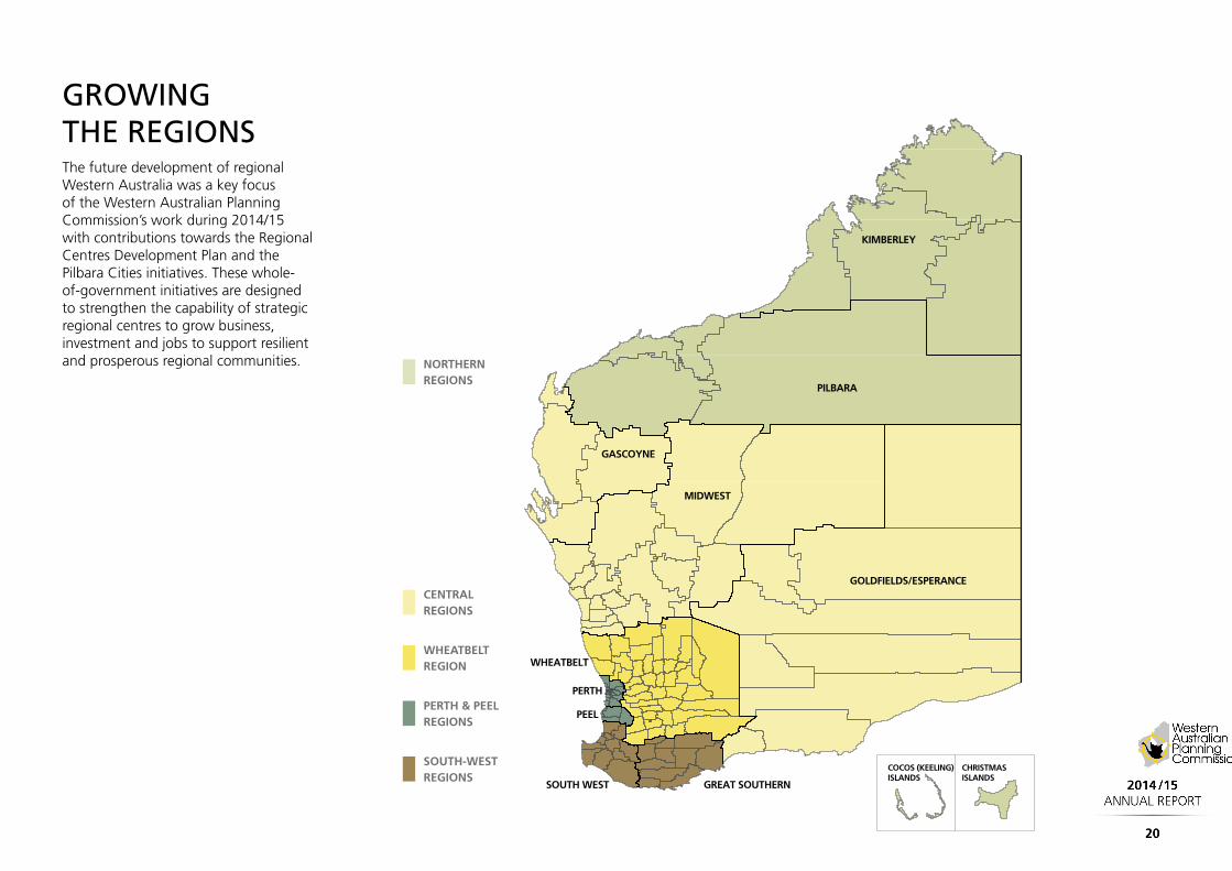
GROWING THE REGIONSThe future development of regional Western Australia was a key focus of the Western Australian Planning Commission’s work during 2014/15 with contributions towards the Regional Centres Development Plan and the Pilbara Cities initiatives. These whole-of-government initiatives are designed to strengthen the capability of strategic regional centres to grow business, investment and jobs to support resilient and prosperous regional communities. NORTHERN
REGIONS
CENTRAL REGIONS
WHEATBELT REGION
PERTH & PEEL REGIONS
SOUTH-WEST REGIONS

KIMBERLEY
� The Commission’s Kimberley regional planning and infrastructure framework (RPIF) was advertised publicly in 2014. It is closely aligned with the Kimberley Regional Investment Blueprint, which together provide a comprehensive future development and land use planning strategy for the region.
� The Commission finalised the Dampier Peninsula Planning Strategy to guide future development on the Dampier Peninsula.
� Department of Planning officers worked closely with Shire of Broome, Shire of Halls Creek and the Shire of Wyndham-East Kimberley to prepare and publically advertise local planning strategies and undertake comprehensive local planning scheme reviews which will be resolved in 2015.
� Local Planning Strategies prepared by local governments provide the rationale for statutory decision-making. The Commission endorsed four local planning strategies in the Central Regions area.
� The Commission’s Mid-West, Gascoyne and Goldfields-Esperance regional planning and infrastructure frameworks (RPIFs) were finalised and released in 2015. The RPIFs were prepared to provide an overall strategic regional context for land use planning within each region; and to identify a number of priority initiatives required to facilitate comprehensive regional planning to guide sub-regional and local planning processes.
� The Commission’s recommendations on the Coral Bay Settlement Structure Plan 2014 (Structure Plan) resulted in Cabinet consideration and its ultimate release in April 2015. The Structure Plan provides a 25-year planning framework for future development and expansion of tourism within Coral Bay.
PILBARA
� During 2014/15, work continued with key stakeholders (i.e. LandCorp, local developers, and local government) to implement the Pilbara Cities vision across the region. Significant development pressure in Karratha, Port Hedland, Onslow and Newman required the preparation of studies and strategies to facilitate orderly planning. Key examples include: modelling/mapping of coastal hazards and risks (Port Hedland and Karratha), endorsement of town site development plans (Onslow); and assessment of local planning scheme amendments/subdivisions.
� Work has progressed with the City of Karratha, the Shire of East Pilbara and the Shire of Ashburton to prepare local planning strategies and undertake comprehensive local planning scheme reviews which will be resolved in 2015.
� The Department of Planning is working collaboratively with the Department of State Development and LandCorp to undertake comprehensive planning of the Strategic Industrial Area (SIAs) across the region – i.e. Ashburton North, Anketell, Maitland - through preparation of Improvement Plans and Schemes, which will provide an effective land use planning framework to ensure the needs of proponents and the State can be met.
NORTHERN REGIONS
CENTRAL REGIONS

GREATER BUNBURY URBAN AND INDUSTRIAL EXPANSION AREAS
� The Greater Bunbury Strategy, released in December 2013 by the Commission identified two major development areas for the future growth of Greater Bunbury.
� The urban area located east of the Eaton town centre and recently named Wanju, following a naming process by the Shire of Dardanup, covers an area of 1100ha and will be the future home to up to 70,000 people. It will be primarily a mix of residential, commercial and town centre development but will also contain 70 hectares of regional playing fields, schools, medical facilities and other general social infrastructure.
� Immediately to the south of Wanju is the proposed new Waterloo Industrial Estate with an area of 1500 hectares. It is anticipated that there will be a mix of light and general industry in the estate which is well serviced by the existing and proposed new road networks. It is located adjacent to the existing Perth/ Bunbury rail line which has direct access to the Bunbury Port.
SOUTH-WEST REGIONS
Future industries may include freight/logistic hub as well as a possible future food processing precinct.
� Work was progressed on district level structure plans, likely to be released for public advertising early in 2016. Once finalised and endorsed by the Commission, these areas will guide development in Greater Bunbury to at least 2050.
� Steady demand for structure plans and subdivisions for commercial and industrial development associated with the Bunbury Port and industrial complexes.
� Planning has progressed on Busselton Airport with a subdivision approval issued by the Commission to allow for a further runway extension and airport infrastructure expansion.
� Work continued on the key findings of the Kemerton Park Strategy Plan, including a Structure Plan and Scheme amendment to facilitate growth in new enterprises at the Kemerton Strategic Industrial Area.
� The Back Beach Tourism Precinct for Bunbury was approved in 2015. The
project involved a Scheme Amendment and Structure Plan to allow a significant tourism development including hotel and serviced apartments development along the Bunbury Beachfront/CBD.
� Further subdivision and structure plan approvals were provided for:
� Treendale Activity/District Centre
� Dalyellup Activity/District Centre
� Eaton Activity/Town Centre.
� The following outcomes were also achieved during 2014/15:
� 44 Scheme amendments to be completed and signed off by the Minister.
� 8 Scheme amendments currently with the Minister awaiting a decision.
� 2 Local Planning Schemes were completed for Busselton and Donnybrook-Balingup.
� 2 Local Planning Strategies were completed for Donnybrook-Balingup and Dardanup.
GREAT SOUTHERN
� A review of the 2007 Lower Great Southern Strategy (LGSS) commenced in late 2014 with a draft strategy likely to be advertised in 2015. The Lower Great Southern sub-region will be the focus of considerable population growth, economic development and infrastructure investment in the medium-term.
� Planning for redevelopment of the Middleton Beach Activity Centre (‘Esplanade site’) is underway to deliver the planning objectives established in Improvement Plan 40. A working group supported and chaired by the Department of Planning and including representatives from LandCorp, Department of Lands, City of Albany and the Great Southern Development Commission provide key agency perspectives and guidance on future planning of the site. Extensive community consultation has occurred and further consultation will be achieved through any future statutory planning related to the site.
� The Bremer Bay town centre structure plan was finalised in May 2015. The structure plan provides mixed use, retail and commercial, civic, and residential precincts; and a 4 hectare parks and nature reserve performing an important ‘macro corridor’ linkage function to the Fitzgerald River National Park.
� The Shire of Broomehill-Tambellup local planning strategy was endorsed by the Commission in April 2015.

This core service entails the acquisition, management and disposal of properties reserved under the Metropolitan, Peel and Greater Bunbury region schemes for primary and other regional roads, parks and recreation and regional open space areas, special uses including planning control areas and improvement plans and major land development projects.
Property acquisitionThe Commission’s land acquisition program for 2014/15 included the purchase or payment of compensation for 49 properties totalling 213 hectares at a cost of $53.1 million.
Roads In meeting strategic infrastructure plans for the future, a total of 31 properties were purchased comprising 41.6 hectares at a cost of $25.56 million for the following road types:
Primary Regional Roads
� Boyanup - Picton Road
� Bunbury Port Access Road
� Bunbury Outer Ring Road
� Waroona Bypass
� Shepperton Road (2 properties)
� Guildford Road (2 properties)
� Kwinana Freeway (Freight Network)
� Canning Hwy
� Perth Darwin Hwy (3 properties)
� Roe Hwy
� Mitchell Freeway (3 properties)
� Mandjoogoordap Drive (finalised acquisitions for the future Meadow Springs Interchange)
Other Regional Roads
� London St, North Perth
� Lord Streets, Highgate and Bassendean
� Loftus St, North Perth
� Fitzgerald St, North Perth
� Lloyd St, Hazelmere and Midland
� Henley Brook Ave, Henley Brook
� West Swan Rd, West Swan
� Scarborough Beach Rd, Woodlands
� Main St, Balcatta
� Beaufort St, Mt Lawley
Railways Two properties totalling 11.6133 hectares were purchased for the extension of the northern suburbs railway at a cost of $11.61million. These purchases represent 2.3 kilometres of the future rail corridor at Alkimos and Eglinton.
Bush ForeverFive properties comprising 21.48 hectares were purchased at a cost of $3.190 million for Bush Forever sites:
� Stakehill Swamp Site 275 (2 properties),
� Yanchep National Park and Adjacent Bushland Site 288,
� Greater Brixton Street Wetlands Site 387, and;
� Thomsons Lake Nature Reserve and Adjacent bushland Site 391.
The Commission also contributed land to the value of $9.76 million or 90 per cent of the funding toward the Main Roads WA purchase of Bush Forever Sites 368 and 372 “Lowlands” at Mardella. These sites totalling 1312.3 hectares were purchased as part of the environmental mitigation and offset requirements for the “Gateway Project” at Perth Airport. The land is now a Class “A” Crown reserve for Flora and Fauna under the management of the Conservation Commission.
SERVICE 3 ASSET MANAGEMENT

Parks and Recreation (regional open space)A total of 15 properties comprising 171.35 hectares were purchased at a cost of $15.39 million or compensation for injurious affection paid.
River and ocean foreshoresThe Commission continued long-standing Government policy of bringing the ocean and major river foreshores into public ownership for future access. Nine properties were purchased or compensation at the full market value paid totalling $9.768 million involving 76.1467 hectares:
� Indian Ocean Foreshore at Two Rocks and Capel
� Capel River
� Preston River
� Collie River
� Canning River (2 properties)
� Helena River.
Regional parksFive properties comprising 94.5664 hectares were purchased at a cost of $5.182 million for regional parks in the metropolitan, Peel and Greater Bunbury Region Planning Schemes:
� Jandakot Regional Park (63.1ha) - Canning Vale
� Yellagonga Regional Park (0.67ha) – Woodvale
� Peel Regional Park (3 properties at Nirimba, Barragup and South Yunderup).
The Commission also purchased the remaining 0.4 hectares of land required to complete the regional open space reserve at Mandurah suburb of Parklands.
Property Disposals Property disposals comprise predominantly of remainder land purchased for strategic purposes but now surplus to requirements following changes to regional planning. Surplus land may also include subdivided land where the required portion of the original lot has been subdivided and transferred to the end land user (e.g. Main Roads WA) and the surplus balance is available for disposal.
During 2014/15, 64 lots totalling 268.23 hectares were transferred to the State for parks and recreational purposes including Herdsman Lake Regional Park, Bush Forever Site 493 (Errina Road Bushland), Black Lake
and Geogrup Nature Reserves within the Peel Regional Park and Nature Reserve 44986.
A total of 11 lots were dedicated free of cost for Other Regional Roads within the Cities of Gosnells, Stirling, Rockingham, Swan and Vincent. A further 16 properties were transferred to Main Roads WA for $15.6 million for the Mitchell Freeway, Great Eastern Highway, Perth-Darwin Highway and the Bunbury Port Access Road, Two properties were sold to the Public Transport Authority for a new busway at Cockburn Central and the Wellard Train Station site for the construction of a new telecommunications tower.
The Commission continues to be an interim land manager; however, in circumstances where land is no longer required, it disposes of these parcels at market value through a disposals program on the open market.
Six properties were sold by auction, private treaty and by land exchange for a total of $20.38 million including lots in Claremont Crescent, Swanbourne following the removal of this regional road from the Metropolitan Region Planning Scheme and at Hazelmere. A further six lots at Cockburn Central West were sold to LandCorp for $5,000,000 for the regional aquatic and recreation centre which incorporates new training facilities for the Fremantle Football Club. Two properties at Redcliffe and Greenmount were sold to the Department of Housing for $767,500.

Whiteman ParkThe popularity of Whiteman Park has continued to grow with visitor numbers maintaining an average annual increase of 11 per cent. Park management has put strategies in place to cope with the rising visitation rate and associated challenges through a five-year management plan.
The park has continued to build on its successful education programs for school groups with increased day/night park tours both and a series of public events in partnership with other organisations, some attracting more than 15,000 visitors. In 2014 Whiteman Park received a Bronze Medal at the WA Tourism Awards in the Tourist Attraction category.
In December 2014 the park experienced its largest wild fire in 10 years burning through nearly 400 hectares of conservation area – 10 per cent of the park’s total area. The fire was attended by over 100 fire units from the Department of Fire and Emergency Services, Volunteer Brigades and Whiteman Park as well as helicopter and water bomber plane support.
The fire-affected stage 1 and 2 of Woodland Reserve resulting in damage to infrastructure and the loss of some of the breeding program Woylies; however losses were very low due to the fast action of staff opening the enclosures ensuring an escape route for the animals within the sanctuary.
Whiteman Park has subsequently reviewed and updated its Fire Management Strategy with assistance from DFES and the City of Swan
to help reduce the threat of wild fire in the future.
Woodland Tours were suspended while infrastructure was replaced but reintroduced in February 2015 to showcase and educate the public about fire damage and the resilience of the Australian bush.
In the 2014/15 financial year the following capital and community projects have been achieved:
Capital Works
� completion of Phase 2 of the Fire Suppression System;
� upgrades to the Lord St entry and installation of a bus stop for visitors within the park;
� footpath and car park upgrades;
� Zamia Train station has been upgraded completing the upgrades of all the train stations within the park; and
� location maps have been installed throughout the park to assist visitors.
Park and Community Projects
“I’ve Been Working on the Railway” National Touring Exhibition
The exhibition focussed on building the standard gauge railway in Western Australia and particularly in the Pilbara. Much of the labour was provided by men from the Torres Straits, many of whom settled permanently in
the State. Many Torres Strait Islander families came specially to see it, most notably four generations from Tom Price and also from Kalgoorlie.
‘Singing the Train’ exhibition
The exhibition was a collaboration between the Wangka Maya Pilbara Language Centre in Port Hedland, AIATSIS in Canberra and Revolutions Transport Museum and featured a 1964 recording in Nyamal language. The song, fully translated to English for the first time, brought senior Nyamal speakers together and was an important event for AIATSIS celebrating the 50th year of its operation with the release of one of its earliest audio archives into the public domain for the first time, in a museum setting.
Project 100k
A partnership between Whiteman Park and Men of the Trees saw 2000-plus volunteers attempt to break a world record by planting 100,000 native seedlings in an hour in a degraded area of Whiteman Park.
In 2015, the record was officially recognised by the Guinness Book of World Records and now Whiteman Park along with Men of the Trees are the official world record holders having planted nearly 104,000 seedlings in approximately 40 minutes. The record was formerly held by India.
www.whitemanpark.com.au

Hester ParkHester Park in Langford/Beckenham is owned by the Commission and is managed in conjunction the City of Gosnells and Swan River Trust. The Master Plan will facilitate the redesign of the broader Hester Park Region to incorporate open water wetlands and living streams, re-vegetated areas, cycling and walking trails and amenities including playgrounds, shade and barbeque facilities.
The Master Plan aims to make the area suitable for a mix of active and passive recreational uses and high quality residential development to provide a more active and welcoming community area which is cognisant of its natural setting along the Canning River. The project commenced in 2013/14 and is funded jointly by the Commission and City of Gosnells.
Initial community consultation, including an online survey and Community Fun Day held onsite, have helped identify how local residents and visitors feel about the park, the attributes they most appreciate and the activities they would like see on site.
This information coupled with technical onsite studies including a flora and fauna assessment, archaeological and ethnographic heritage study, transport strategy and district water management strategy will inform the location of potential residential lots and parkland features including, but not limited to, areas of revegetated bushland, playgrounds, walking and cycling trails, and picnic facilities including shade, shelter and barbeque facilities.
This project continues to be driven by the community and detailed consultation will be ongoing to ensure that the broader community is aware and involved in this exciting project.

Ministerial directivesIn accordance with Treasurer’s Instruction 903(12), the Western Australian Planning Commission received no Ministerial directives in 2014/15.
GovernanceSubstantial work has been undertaken during the 2014/15 financial year to reinforce good governance principles across all aspects of the Western Australian Planning Commission’s operations. This has resulted in the development of a four-year Strategic Plan and a new Board Charter.
Strategic PlanThe Western Australian Planning Commission’s newly-developed Strategic Plan 2015-2017 states:
The Western Australian Planning Commission will take a lead role in shaping the future of Western Australian in a sustainable manner through leading whole of government in integrated strategic and statutory land use planning, land development and infrastructure coordination.
The plan is structured around six overarching themes:
� Plan for growth: create world-class liveable cities, towns and regions with diverse choices for communities to thrive and prosper; through sustainable development, maintain Western Australia’s environment.
� Co-ordinated and collaborative land use planning: collaborate to ensure Western Australia’s infrastructure supports development and connects the State’s diverse communities.
� Responsible economic development: facilitiate commerce, investment, innovation, employment and community betterment.
Governance and other disclosures
FIGURE 4: WESTERN AUSTRALIAN PLANNING COMMISSION CONTINUOUS STRATEGIC PLANNING CYCLE
� Land and property: manage Commission land and property assets effectively.
� Simplify and reform planning processes: simplify and reform planning system and processes; ensure the effectiveness of the planning system to support Western Australia’s ongoing development.
� Governance: exercise good governance.
Objectives, performance outcomes and strategic imperatives have been identified within these themes to guide the Commission’s work over the next four years.
WAPC Meetings and Committees
WAPC Quarterly Strategic
Conversations
WAPC Budget
WAPC Annual Report and Ministerial
Reporting
WAPC Annual Achievement Plan
WAPC Strategic Plan
Ministerial Priorities
Plans and Policies (eg. SPS)
Emergent Strategic Issues and Stakeholder
Collaboration

The Commission’s strategic plan aligns with the Department of Planning’s strategic plan and with the State Government’s performance management framework that guides the development of policies, programs and services.
Board CharterA Board Charter that outlines the obligations and responsibilities of the Commission board and its members was developed during 2014/15. It provides clearly-defined governance principles on issues such as the relationships between the Board and the State Government and the Department of Planning, remuneration and protection, conduct, operations, and performance evaluation.
The charter was developed following input by the Public Sector Commissioner and the State Solicitor General. It considers all aspects of board governance and operations including:
� the role of the Commission board, including business and operational plans and performance monitoring;
� the board structure, including roles and responsibilities of the chairperson and members;
� board remuneration and protection;
� conduct, including a code of ethics and conduct and security of information;
� board operations including meetings protocols and processes;
� the relationship between the board and the Director General and staff of the Department of Planning;
� the relationship between the board and Government; and
� reporting and performance evaluation.
Planning reformsin September 2009, the Planning Makes It Happen: Blueprint for Planning Reform report was launched which set out a comprehensive reform agenda for the Western Australian planning system. Reform initiatives outlined in Phase Two, launched in August 2014, were progressed, including the preparation of new Planning and Development (Local Planning Schemes) Regulations 2015, and reviewing the Planning and Development Act 2005, the Metropolitan Region Scheme and the Structure Plan Preparation Guidelines.
The ‘Planning Reform for Better Design’ project has commenced to investigate and research mechanisms to improve built form and place design outcomes. Consultation with relevant stakeholders, including local government and the design industry, continues to progress, with the project anticipated to be completed within the next 12 months.
LPS RegulationsThe new Regulations include improved processes for the preparation of local planning schemes, the introduction of new risk-based scheme amendment processes, the streamlining and standardisation of the structure plan approvals process and the standardisation and expansion of the list of exempt development.
In November 2014, the Regulations and associated discussion paper were released for public comment.
The Regulations will result in substantial changes to the planning system and affect the operational arrangements for local planning strategies, schemes, scheme amendments and structure plans. As a result, a range of implementation measures need to be in place to ensure that the new Regulations are introduced and the planning industry has access to information on the new arrangements. This work is currently being undertaken by the Department of Planning, in consultation with a number of key stakeholders including WALGA and the UDIA.

2015 Client Satisfaction SurveyEach year a client satisfaction survey is carried out on the operations of the Western Australian Planning Commission and the Department of Planning to ensure that the standard of service more than adequately meets clients’ needs. Data collected through the survey are used to inform the Commission’s Key Performance Indicators.
The 2015 survey found that overall satisfaction with the Commission Chair and committees was fairly high, with more than 70 per cent of survey participants reporting that they were moderately to extremely satisfied.
More than 70 per cent of metropolitan and 65 per cent of regional respondents were satisfied with the Commission’s role in providing strategic direction in planning during 2014/15.
SATISFACTION WITH WAPC STAFF
SATISFIED (MODERATELY, VERY, EXTREMELY)
VERY SATISFIED (VERY & EXTREMELY)
Access to the Chair and committee 85.7 71.4
Professionalism 82.6 63.0
Listened to and views considered 78.3 56.5
Overall outcome 69.6 47.8
Internal auditIn accordance with a Service Delivery Agreement between the Department of Planning and the Commission, the Department’s internal audit function provides an independent and objective assurance and consulting service to the Commission.
Internal Audit conducts comprehensive audits in accordance with an endorsed Internal Audit Charter and Audit Program. The key reviews undertaken in 2014/15 included:
� Governance Framework of the Commission’s Board of Management and Statutory Committees
� Management of Metropolitan Region Improvement Tax Revenue.
In addition, Internal Audit conducted a number of reviews to provide the Department with assurance that adequate and appropriate controls were in place for various functions and activities that are undertaken by the Department on behalf of the Commission. For 2014/15, these audits included:
� Ministerials
� The Commission’s Delegations to departmental staff.
The reports from the above audits are tabled at the Executive, Finance and Property (EF&P) Committee. Recommendations from internal audit reviews that impact on the Commission are managed and monitored through the Department’s Audit Recommendation Management System. Progress reporting on

the status of the agency’s implementation of internal audit recommendations impacting on the Commission is reported to the EF&P Committee.
External auditApart from the Office of the Auditor General’s financial attest audits, the Commission was not included in any other specific audits 2014/15.
Recommendations from external audit reviews that impact on the Commission are managed and monitored through the DoP’s Audit Recommendation Management System. Progress reporting on the status of the agency’s implementation of external audit recommendations impacting on the Commission is reported to the EF&P Committee.
Probity
Advertising and marketing expenditure
In accordance with Section 175 ZE of the Electoral Act 1907 The Western Australian Planning Commission incurred the following expenditure with advertising, market research, polling, direct mail and media advertising.
ADVERTISING AND MARKETING EXPENDITURE
Western Australian Planning Commission
Advertising agencies Nil
Direct mail organisations Nil
Market research organisations
Reach Solutions 14,980
Media advertising organisations
Adcorp
Optimum Media Decisions (WA)
Marketforce Advertising
Professional Public Relations
71,353
93,647
3,269
204
668
Polling organisations Nil
TOTAL 184,121
Major capital projectsDetails of major capital projects at 30 June 2015 on accordance with Treasurer’s Instruction 903 Section 13 (ii) (a) (b) are listed below:
PROJECT NAMEEXPECTED YEAR OF COMPLETION
ESTIMATED COST TO COMPLETE
$’000
ESTIMATED TOTAL COST OF PROJECT
$’000
WAPC
Acquisition of Land Ongoing 31,306 36,326
Regional Land Acquisition Ongoing 7,104 6,935

MR ERIC LUMSDEN PSM
Chairman
Eric Lumsden was formally appointed Commission Chairman in 2013, following 12 months in that role while also concluding six years as the Director General for the Department for Planning and Infrastructure (and latterly the Department of Planning). He was previously CEO of the City of Melville and the City of Swan. Mr Lumsden holds masters degrees in town planning and business administration, and post graduate qualifications in local government and social sciences.
He is a life fellow of the Planning Institute of Australia, fellow of the Australian Institute of Management, and fellow and past president of the WA Division of the Local Government Managers Association. In 2005 Mr Lumsden was awarded a Public Service Medal for his contribution to local government, especially in the area of economic development. In 2012 he was made a National Fellow of the Institute of Public Administration of Australia and in 2015 was awarded the Dr Ken Michael Gold Medal by the Institute of Public Works Engineering Australia.
CR VERONICA FLEAY
Local government (non-metropolitan) representative
Veronica (Ronnie) Fleay has an extensive record of high-level community, State Government and local government service, as well as several years’ experience as a small business operator. Kojonup-born Ms Fleay lived in Exmouth for 12 years before returning to the Great Southern in 2011.
She has served as Chair of the Gascoyne Development Commission and sat on the Gascoyne Regional Council, the Western Australian Planning Commission, the Ningaloo Coast Planning Committee and the Western Australian Local Government Association. Former President of the Shire of Exmouth, Ms Fleay is currently Kojonup Shire President.
MR PAUL DRECHSLER
Professional representative
Paul Drechsler, former Group Managing Director of national architectural and planning practice, Hames Sharley, has been a Commissioner of the Western Australian Planning Commission since 2010. As a professional Town Planner, Geographer and Land Economist Paul has 40 years’ experience in urban and regional planning, commercial and retail development feasibility studies, urban design and large-scale land development.
Paul has a double major in geography and biological science and is a PhD candidate at the University of Western Australia. His research focus is on the retail sector; place consumption, experiential shopping environments and the impact of digital technologies and e-commerce on physical retail platforms. He is Deputy Presiding Member of the North West Metropolitan Development Assessment Panel and an alternate Presiding Member for all metropolitan DAPs.
Paul’s professional affiliations include Fellow of the Planning Institute of Australia, Fellow of the Australian Property Institute and member of the Institute of Australian Geographers.
appendices
Appendix 1: Western Australian Planning Commission members (as at 30 June 2015)

PROF ROBERT HARVEY
Professional representative
Professor Harvey commenced his career as an engineer in the then Water Authority, specialising in resource management, planning and policy. His last position in the Authority was as Director Water Resources Planning.
As an Executive Director at the Department of Justice from 1999 to 2003, he was responsible for community corrections, juvenile justice and correctional policy. He oversaw the introduction of the State’s first privately- operated prison and made significant improvements to an important part of the State’s criminal justice system. From 2003 to 2009 Professor Harvey was Pro Vice- Chancellor and Dean of Business and Law at Edith Cowan University. He has also been a member of the Water Corporation Board since 2007. On behalf of the Board of the Water Corporation, he convened a scientific panel to review the State’s 50-year water plan — Water Forever.
MR GLEN KELLY
Indigenous interests representative
Glen Kelly is the Chief Executive Officer of the South West Aboriginal Land and Sea Council, the Native Title representative body for the South West of Western Australia. He is a Wardandi Noongar man and possesses a Bachelor of Environmental Science degree.
Mr Kelly has been working in the Aboriginal community sector since the early 1990s and specifically in protected area, land and cultural resource management and, since 2001, in the area of native title. He has served on a number of committees and statutory boards at both Australian and State levels.
DR GARRY MIDDLE
PH.D.; M. Phil. (Urban Studies); C.Sc. (Hons Env. Sc.); S.SC. (Chem) Dip. Ed.
Coastal Planning and Management representative
Associate Professor Garry Middle heads the Department of Urban and Regional Planning at Curtin University. He has more than 30 years’ experience in environment planning, policy and governance; environmental impact assessment; strategic environmental assessment; and coastal planning, working with State and local governments as a consultant and an academic.
Before joining Curtin University in June 2008 Dr Middle was the Appeals Convenor for the Minister for Environment and prior to that was Director, Environment and Natural Resource Planning at the Department for Planning and Infrastructure; Manager, Strategic Planning and Environment at the City of Rockingham; and Manager, Environmental Planning Branch servicing the Environmental Protection Authority.
Dr Middle sits on the WA Planning Institute of Australia’s Division Committee and is a member of the International Association of Impact Assessment.

MAYOR HENRY ZELONES
Local government (metropolitan) representative
Mayor Henry Zelones JP was elected as a Councillor at the City of Armadale in 1989. He serves as Chairman of the Armadale Development/ Planning Services Committee, a position he has held for the past 20 years. He is a board member of the Armadale Redevelopment Authority (2002), WA Local Government Association State Council (2005), WA Heritage Council Board Member (2008) and Deputy Commissioner WAPC (2004) and Commissioner WAPC (2010).
Mayor Zelones has been closely involved with local government reform, chairing WALGA’s Planning Reform Policy Forum and local government reform committees. He has extensive experience in private industry, having establishing his own business in 1971. He has served as a board member of the Chamber of Commerce and a member of the local Business Association for more than 30 years. He also has a background in information technology.
MR ROSS THORNTON
Local government (non-metropolitan) representative
Ross Thornton is a qualified town planner, registered builder and is presently farming in Denmark. Much of his early career focussed on residential/commercial and subdivisional development.
As Shire President (Denmark) and Deputy Chair of the Great Southern Development Commission his focus is on coordinating and supporting endeavours that build a strong and integrated regional economy through appropriate regional development.
MS GAIL MCGOWAN
Director General, Department of Planning
Gail McGowan was appointed the Director General of the Department of Planning in April 2014 for a five-year term. Prior to her appointment, she was the Deputy Director General for the State Initiatives division of State Development, which involved leadership and management responsibility for projects of strategic significance to the State, project approvals and strategic industrial land. Her work centred on negotiating and liaising with stakeholders across industry, government and community.
Ms McGowan’s background includes positions as the Director of Policy and Education at WorkSafe and a number of years as the principal policy advisor and Chief of Staff to State and Federal Ministers of Parliament, with responsibility across a range of portfolio areas including employment and training, industrial relations and the environment.

MR REECE WALDOCK
Director General, Department of Transport
Reece Waldock has more than 25 years’ experience in strategic management with particular expertise in organisational reform. He held a number of senior executive roles within the Department of Commerce and Trade and the Department of Transport.
Prior to his career with the WA public sector, Mr Waldock held a number of senior management roles with BHP.
In 2000, following the sale of the rail freight business of the Western Australian Government Railways Commission, he acted in the position of Commissioner of Railways. With the creation of the Public Transport Authority in 2003, Mr Waldock was appointed as the inaugural CEO and oversaw the integration of all statewide public transport services, together with a major construction program, which included the Mandurah Railway.
In 2010, the State Government integrated its three key transport agencies and Mr Waldock was appointed to head the Transport fortfolio, consisting of the Department of Transport, Main Roads WA and the Public Transport Authority.
MR MIKE ROWE
Acting Director General, Department of Water
Mike Rowe has been the Acting Director General of the Department of Water since November 2014. He is an experienced member of the Western Australian Government’s senior executive service, having worked in a variety of leadership, policy, advisory and delivery roles across nine agencies since 1993 including agriculture, environment, Aboriginal affairs, the public sector commission, Premier and Cabinet and most recently, regional development.
Ms Maree DeLacey, former Director General, Department of Water resigned in November 2014 and was replaced by Mr Rowe, Acting Director General, Department of Water.
MR GRAHAME SEARLE
Director General, Department of Housing
Grahame Searle holds a Bachelor of Business and has extensive experience in service delivery, leadership and organisational change.
From 1998 to 2008 he led the transformation of the Department of Land Administration from a traditional public service agency to its current statutory authority status, Landgate. As Director General with the Department of Housing, he focused on forging new and innovative ways to meet increasing demand including new partnerships with community housing organisations across the State.
Mr Searle has a strong background in information technology and, in particular, integrating computer systems for customer service delivery. He has extensive experience in managing information technology projects in Victoria and Western Australia.
Mr Searle is an Honorary Fellow of the Spatial Sciences Institute of Australia; past president of the Institute of Public Administration (WA Division); and a board member of the WA Treasury Corporation.

MR STEPHEN WOOD
B. Psych; M. Pub. Admin.
Director General, Department of State Development
Stephen Wood commenced his current position in May 2011. He has held a variety of positions across the Commonwealth and State public sectors. He was previously Deputy Director General, Strategic Issues at the Department of Premier and Cabinet; Commissioner of the Western Australian Industrial Relations Commission; Deputy Director General, Department of Premier and Cabinet and a consultant for native title.
MR JASON BANKS
Director General, Department of Environment Regulation
Jason Banks was appointed as the inaugural position of Director-General of the Department of Environment Regulation in 2014 r following 12 months of acting in the role after the department’s creation in July 2013. He led the formation of the agency, overseeing more than 300 staff and driving a range of reforms.
Mr Banks has extensive management experience and has worked more than two decades at a range of State Government agencies including as CEO and co-ordinator of energy at the Office of Energy. He was also instrumental in coordinating the Government’s response to the June 2008 explosion at the Varanus Island gas processing plant.
He has also worked as a senior adviser with the Department of State Development and as a management consultant with the Public Sector Commission. He began his career with the WA Police where he served as an officer and later a detective.
Deputy members for local government representatives
Cr Michael Huston, Cr Valerie Ammon
Mr Ralph Addis (associate member)

Number of meetings and reports
Western Australian Planning Commission
In 2014/15, the Western Australian Planning Commission met 13 times and considered 136 reports.
Western Australian Planning Commission committees:
Committees that met regularly throughout 2014/15 were:
Executive, Finance and Property Committee
The committee performs the administrative, financial and property functions of the Western Australian Planning Commission. Most of its activities centre on monitoring development projects, the acquisition and disposal of property and associated capital works. During 2014/15 the committee met 16 times and considered 114 formal reports in addition to general strategic discussion.
Statutory Planning Committee
The committee is the Commission’s regulatory decision-making body. Its functions include approval of the subdivision of land, approval of leases and licenses, approval of strata schemes, advice to the Minister for Planning on local government town planning schemes and scheme amendments, and the determination of certain development applications under the Metropolitan Region Scheme. During 2014/15
the committee met 21 times and considered 191 formal reports in addition to general strategic discussion.
Infrastructure Coordinating Committee
The committee advises the Western Australian Planning Commission on planning for the provision of physical and community infrastructure throughout the state. It has the powers to coordinate the metropolitan development program, the country land development program and the provision of infrastructure for land development. During 2014/15 the committee met five times and considered 15 formal reports in addition to general strategic discussion.
Special purpose committees
The Commission has created a number of special purposes committees to assist with its land use planning activities across the state. Committees may have specific tasks or be established, as needed, to address a one-off situation. The Commission sets the membership and terms of reference for these committees.
Central Perth Planning Committee
The committee was established to oversee and provide direction for planning in the Perth central area. It exercises delegated authority to deal with the City of Perth town planning scheme and scheme amendments; the Metropolitan Region Scheme and amendments; subdivisions, strata titles, leases and licenses; and development on reserved
land within the City of Perth. During 2014/15 the committee met three times and considered four formal reports in addition to general strategic discussion.
Regional committees
South West Region Planning Committee
The committee is the longest established regional planning committee in the state. It undertakes strategic and statutory decision-making for land planning matters in the South-West region on behalf of the Western Australian Planning Commission. It deals with the subdivision of land, local planning schemes and amendments, the Greater Bunbury Region Scheme and amendments and land development policies for the region. During 2014/15 the committee met four times and considered 30 formal reports in addition to general strategic discussion.
The Peel Regional Planning Committee
This committee was formed to oversee preparation of the Peel Region Scheme incorporating the local government districts of the City of Mandurah and the shires of Waroona and Murray. During 2014/15 the committee met twice and considered four formal reports in addition to general strategic discussion.
Pilbara Regional Planning Committee
The Pilbara Regional Planning Committee met on once in 2014/15 and considered one formal report.
Appendix 2: Western Australian Planning Commission, committees and sitting fees

SITTING FEES
Central Perth Planning CommitteeBeck, Hamish Richard 600Blackwell, Anthony Bowen 1,200Butler, Robert John 1,200Fulker, Marion Celia 800Scaffidi, Lisa-Michelle 1,200
Executive Finance and Property CommitteePerry, Russel John 9,590Strom, Rebecca Allison 3,308Zelones, Henry Anthony 8,582
Peel Region Planning CommitteeBeacham, Brenda Lillian 1,260Chaney, Frederick Charles 630Fitzpatrick, Paul Francis 1,260Germain, Christine Ann 1,260Vergone, Marina Elizabeth 840Williams, Rhys John 420
Pilbara Regional Planning CommitteeCraigie, Lynette Suzanne 410Green, Richard Mark 420Howlett, Kelly 210Jacob, Gloria Ann 410
Appendix 3: Remuneration for committee members
SITTING FEES
Planning CommissionAmmon, Valerie Joy 3,425Drechsler, Paul John 27,410Fleay, Veronica May 12,558Harvey, Robert Anthony 27,410Kelly, Glen Alan 27,410Middle, Garry John 27,410Thornton, Ross Douglas 12,568Zelones, Henry Anthony 27,410
South West Region Planning CommitteeDilley, Stephen Beresford 420Hicks, Stuart Keith 1,590Jackson, Tania Gae 1,890Nicholas, John Digby 210Pimm, Rosanne Bromley 2,430
Statutory Planning CommitteeAubrey, Russell Anthony 4,043Bartle, Megan Anne Adair 12,495Glickman, Raymond Barry 3,308Hiller, Stephen Maitland 4,043Holloway, Ian Janson 13,230Taylor, Elizabeth 16,380
SITTING FEES
ODG Board of ValuesGarmony, Matthew John 960Houlahan, Mark 160Lilburne, Patrick Geoffrey 1,380
TOTAL 259,238
Board members attendance fees 2014/15