tibetan land use and change near khawa karpo, eastern himalayas · pdf fileand tropical floras...
TRANSCRIPT

TIBETAN LAND USE AND CHANGE NEAR KHAWA KARPO, EASTERN HIMALAYAS 1
JAN SALICK, YANG YONGPING, AND ANTHONY AMEND
Jan Salick, Yang Yongping, and Anthony Amend (Curator of Ethnobotany, Missouri Botanical Garden, PO Box 299, St. Louis, MO 63166-0299, e-mail addresses: [email protected], [email protected], and [email protected]). Collaborating Authors: Bee Gunn, Wayne Law, George Yatskievych, Wu Sugong, Fang Zhendong, Ma Jian, Wang Yuhua, Andrew Willson, Peng Shengjing, Zhang Chuanling, Sun Hongyan, Meng Zhengui, Liu Lin, Senam Dorji, Ana, Liqing Wangcuo, Sila Cili, Adu, Naji, Amu, Sila Cimu, Sila Lamu, Lurong Pingding, Zhima Yongzong, Loangbao, Bianma Cimu, Gerong Cili, Wang Kai, Sila Pingchu, Axima, and Benjamin Staver. TIBETAN LAND USE AND CHANGE NEAR KHAWA KARPO, EASTERN HIMALAYAS. Economic Botany 59(4):312-325, 2005. Tibetan land use near Khawa Karpo, Northwest Yunnan, China, incorpo- rates indigenous forest management, gathering, pastoralism, and agriculture. With field-based GIS, repeat photography, and Participatory Rural Appraisal we quantitatively compare land use between higher and lower villages, and between villages with and without roads. Households in higher elevation (>3,000 meters) villages cultivate more farmland (z = -5.387, P <- 0.001), a greater diversity of major crops (z = -5.760, P < 0.001), a higher percentage of traditional crops, and fewer cash crops (z = -2.430, P = 0.015) than those in lower elevation villages (<2,500 meters). Villages with roads grow significantly more cash crops (z = -6.794, P <- 0.001). Both lower villages and villages with roads travel farther to access common property resources. Historical analyses indicate agricultural intensification in valleys, an increase in hous- es, new crop introduction, hillside aforestation, cessation of hunting, glacial retreat, and timber- line advance within the past century. We suggest that Tibetan land use reveals trade-offs between high, remote villages and lower villages near roads. Higher villages offer abundant land and access to natural resources but short growing seasons and little market access; in contrast, lower villages have road and market access, an extended growing season, and modern technology, but limited access to land and many other natural resources.
Key Words: Northwest Yunnan; Tibet; land use; agriculture; non-timber forest products; geo- graphic information systems; participatory rural appraisal; verticality.
Studies of Tibetan land use are few and often concentrate on renowned patterns of nomad pas- toralism on the high plateau (Ekvall 1983; Ning and Richard 1999). Less studied are Tibetan farming (but see Goldstein et al. 2003) and gath- ering (but see Xu and Wilkes 2004; Zhang, Wang, and Geng 2000). Nonetheless, in well- watered regions of the plateau and especially the monsoonal areas of the eastern Himalayas, ag- riculture, forestry, and gathering are important traditional activities central to Tibetan liveli- hoods. Tibetan resource management reflects a sustained human presence since 20,000 B.P. (AI- denderfer and Zhang 2004).
Land use patterns, and particularly the cata-
~ Received 13 June 2005; accepted 11 September 2005.
lysts fomenting their change, are complex and fit poorly with simple explanations (Lambin, Geist, and Lepers 2003; Lambin et al. 2001). Recent land use change is often attributed to globalization in many forms (Ausubel 1996; Grau et al. 2003; Lambin et al. 2001). Though many factors affect Tibetan subsistence activi- ties, including rainfall (Winkler 1988), politics (Goldstein 1973; Goldstein and Beall 2002), and sanctity (Anderson et al. 2004; Guo 2000; Mose- ley 2003), this study examines two variables in particular: elevation and road access.
There is a vast literature on relations among road access, market accessibility, and economic growth (Chomitz and Gray 1996; Wilkie et al. 2000; Windle and Cramb 1997). Roads often cause agricultural change, deforestation, and hab- itat fragmentation (Cropper, Puri, and Griffiths 2001; Forman 1998; Hamlin and Salick 2003;
Economic Botany 59(4) pp. 312-325. 2005 �9 2005 by The New York Botanical Garden Press, Bronx, NY 10458-5126 U.S.A.

2005] SALICK ET AL.: TIBETAN LAND USE 313
Fig. 1. Khawa Karpo located in Deqin County, Northwest Yunnan, China.
Windle and Cramb 1997). Road building is a modem priority in China (Litzinger 2004; Wang et al. 2003) with a sprawling network extending to the most remote regions. So, we investigate the affects of roads on Tibetan land use.
Verticality in subsistence production has been well documented in mountain cultures of the Andes (Mayer 1985; Murra 1968; Zimmerer 1999) and the Himalayas (Maikhuri, Rao, and Semwal 2001; Sinclair and Ham 2000; Zimmer- er 1999). On Khawa Karpo, its steep gradient enhances resource richness (Salick et al. 2004). So, we study elevation as a key environmental variable of Tibetan land use.
Thus, we address the neglected aspects of Ti- betan land use--agriculture, forestry, and gath- e r ing-as well as pastoralism and change af- fected by two common agents, one environmen- tal (elevation) and one socio-economic (roads).
STUDY SITE
Khawa Karpo, the earthly image of the Ti- betan warrior god, is one of the most sacred mountains to Tibetans. It lies on the border of Yunnan and Tibet in the easternmost Himalayas, between the upper Mekong and Salween Rivers, and within the region where the major temperate
and tropical floras of Asia merge (Fig. 1). Kha- wa Karpo has a steep elevational gradient from about 2,000 meters (m) at the Mekong River to its peak (6,740 m) over only 10 kilometers (km) with ecotypes ranging from subtropical scrub in the arid river valleys through oak, humid mixed, and coniferous forests, to alpine meadows, scree, and glaciers on a single mountain slope (Salick et al. 2004). The Hengduan Mountains, in which Khawa Karpo is among the highest peaks, are exceptionally diverse and considered a "hotspot" (Mittermeier et al. 1998). For all these reasons and because of major conservation efforts of The Nature Conservancy, we chose Khawa Karpo as our study site.
Six ethnic Tibetan villages were selected for this study based on elevation (two are higher than 3,000 m, four are lower than 2,500 m; see Table 1), access to roads (three are with roads, three are without), and their depictions in Joseph Rock's photos from the early 1900s. While roads facilitate transportation to Deqin, the principle market town in the area, none are completely paved and frequent landslides block traffic. In the absence of roads, villagers rely on their backs, horses, mules, and yaks to transport goods by trail.
314 ECONOMIC BOTANY [VOL. 59
TABLE 1. TIBETAN VILLAGES NEAR KHAWA KARPO WERE SELECTED FOR ROAD ACCESS (1, 2, 3 W1TH
ROAD; 4, 5, 6 WITHOUT ROAD), FOR ELEVATION (1, 2, 3, 5 < 2 , 5 0 0 METERS; 4, 6 > 3,000 METERS),
AND FOR THE HISTORICAL PICUTURES TAKEN OF THEM BY JOSEPH ROCK IN THE EARLY 1900S.
Distance to road Total cultivated land Village (in meters) Elevation (in meters) Number of households (in square meters)
1 0 2,490 127 623,242 2 0 2,388 24 148,706 3 0 2,068 31 228,311 4 2,550 3,095 15 185,839 5 4,645 2,170 91 404,053 6 5,630 3,100 17 150,385
METHODS During May 2004, field research was con-
ducted within each of six villages by a team con- sisting of a botanist, a GIS technician, a Partic- ipatory Rural Appraisal (PRA) facilitator, two Chinese graduate students, two Tibetan doctors, two village participants (one man and one wom- an), and one translator. Three such teams spent five days each in two villages.
PRA mapping was popular among Tibetan villagers, who sketched their local surroundings on large sheets of paper, highlighting major landmarks (mountains, rivers, sacred sites, roads, trails, pastures, fields, buildings, etc.) and locations of key resources (forests, fuelwood, medicinal plants, mushrooms, etc.). These maps were then transferred to GIS maps in order to identify landmarks and measure distances to re- sources. Other PRA activities included semi- structured and informal interviews on land use (with GIS below) and historical change. Joseph Rock took photographs in most of the villages early in the twentieth century; these photos were shown and used to discuss historical change with village elders who could remember this earlier period (Fig. 2). In each village, between one and five elders were engaged in the semi- structured interviews based on the photos and their recollection of land use history, including number of households, amount of land farmed, crops grown, resources collected, pastures, ani- mals, markets, roads, and overall living condi- tions.
GIS mapping used lkonos 1 m/pixel resolu- tion, orthorectified satellite images of villages. The images were converted to MrSID format and viewed through ARCPad (ESRI 2002) on Compaq iPAQ PDAs. Polygons of field and pas-
ture boundaries and points of gardens, buildings, and other structures were mapped onto the im- ages using a Garmin etrex GPS unit attached to the PDA. Alternatively, these polygons and points were traced by hand over the satellite im- ages. Information about the polygons and points also were entered into the PDA. Field and pas- ture polygons attribute information included the following: associated household or common property status, crops, crop variety, seed source, chemical and organic inputs, and crop rotation data; for gardens only household and crops were recorded; for houses information included the household name, the number of occupants, and the date of construction; for other buildings and structures the information was identity, house- hold or common property, date of construction. Since Chinese law regulates the use of carto- graphic equipment, Chinese citizens conducted GIS fieldwork. Polygon area was calculated us- ing a script (Zhou 2001) in ArcView GIS 3.2 (ESRI 1992-1999). Resource distance was cal- culated using ARCMap 9.0 (ESRI 2004).
Before and since collectivization of lands (1960s-1980s), a Tibetan household--all inhab- itants of a given house sharing economic and natural resources and considered a single entity by the village's governing body--is the basic unit of agricultural production. The household is used as the basis of most of our analyses unless otherwise stated. Crops in fields and gardens were identified by villagers and vouchered if identification was in question. All fertile non- timber products and trees were vouchered and located by GPS. Vouchers are deposited at the Kunming Institute of Botany and the Missouri Botanical Garden.
Statistics calculated include the richness or
2005] SALICK ET AL.: TIBETAN LAND USE 315
Fig. 2. Examples of historic photos of study sites taken by Joseph Rock in 1923 (A and C) and modern repeats (B taken in 2004 and D taken in 2003), which show subtle differences in land use. A comparison of Rock's historic photo A with modern photo B shows a bit more modern forest cover and less modern hillside agriculture (right). A comparison of Rock's historic photo C with modern photo D reveals some new terracing, irrigation, and cultivation of land (left) as well as more houses and walnut trees (center).
number of species (S) and Shannon's diversity H' = - s (ni/N) log (ni/N) (Shannon and Weav- er 1949). Normality was tested using the Sha- piro-Wilk test, and since all data were distrib-
uted non-parametrically or were percentages, Mann Whitney rank sum statistics (Z) and Krus- kal-Wallis for K independent samples (X 2) were computed using SPSS (2003).
316 ECONOMIC BOTANY [VOL. 59
TABLE 2. FIELD CROP AREAS IN SQUARE METERS
(M 2) CULTIVATED PER HOUSEHOLD IN LOWER AND
HIGHER VILLAGES. THESE NON-PARAMETRIC STATIS-
TICS (THUS NO STANDARD DEVIATION REPORTED)
DEMONSTRATE THE DIFFERENCES IN ELEVATIONAL
CROPPING PATTERS AND AREAS CULTIVATED (SEE
FIGURE 3 AND TEXT FOR STATISTICAL RESULTS).
COMMERCIAL GRAPES DO NOT THRIVE AT HIGH EL-
EVATIONS, WHILE BARLEY, BUCKWHEAT, POTATOES,
AND TURNIPS DO. MORE LAND IS CULTIVAED PER
HOUSEHOLD IN THE HIGHLANDS DUE TO ABUNDANT
AVAILABLE LAND AND TO THE SHORT GROWING SEA-
SON WITH SINGLE YEARLY ROTATIONS AND REDUCED
YIELDS.
Lower villages: mean Higher villages: mean area cultivated in area cultivated in
square meters (m z) square meters (m 2) Major crops per household per household
Barley 600 2,600 Buckwheat 70 800 Cabbage 1 30 Maize 600 1,400 Potato 50 300 Turnip 0 80 Walnut 50 200 Wheat 2,000 3,000 Grape 300 0 Households (N) 270 32
RESULTS
CULTIVATED A R E A
The area of land cultivated per household (Fig. 3) is significantly greater in higher villages (Mann-Whitney: z = -5 .387, P < 0.001). Cul- tivated land area in higher villages is 10,507 + 1,171 square meters per household (mZ/house - hold), while lower villages cultivate only 5,144 -+ 890 mVhousehold. The area of cultivated land per household is not significantly different be- tween villages with and without road access Mann-Whitney: z = - 1.19, P = 0.230).
FIELD CROPS
Field crop areas (m 2) cultivated per household m lower and higher villages (Table 2) describe some differences in elevational cropping pat- terns and areas cultivated. Commercial grapes do not thrive at high elevations, while barley, buckwheat, potatoes, and turnips do. More land is cultivated per household in the highlands due to abundant available land and to the short grow- ing season with single yearly rotations and re-
duced yields. However, to avoid biasing land use comparisons by area cultivated and to concen- trate on crops, the percentage of cultivated areas is compared among villages. Households in high villages grow a significantly greater percentage of traditional Tibetan crops (Fig. 3) including barley (• = 29.135, P < 0.001), buckwheat (X 2 = 14.962, P < 0.001), cabbage (• = 20.068, P < 0.001), and turnips (X 2 = 51.661, P < 0.001). They also grow greater percentages of American crops including potatoes (X 2 = 50.718, P < 0.001) and maize (• = 25.566, P < 0.001), al- though the latter is grown in special lower-ele- vation fields. Households in lower villages grow a significantly greater percentage of commercial grapes (X 2 = 6.972, P = 0.008).
In higher villages the extreme elevational gra- dient is used to cultivate a variety of crops (Fig. 4). Maize and walnuts are grown only at lower elevations while barley is grown mostly higher. Higher villages have scarce, smaller cropping areas lying approximately 200-300 m below the village for cultivating these lower elevation crops. Of the agricultural households surveyed in the higher villages, 88% cultivate land in both high and lower areas. In these lower areas, corn is the most common crop, comprising 84% of the total. Other crops (e.g., buckwheat and yel- low beans) also are planted in the lower zone, but in the season of this study (spring), these minor crops are infrequent.
Households in higher villages have signifi- cantly greater field crop diversity (Mann-Whit- ney: z = -5 .760, P < 0.001, Fig. 3). Road ac- cess does not significantly affect field crop di- versity. Households nearer to roads, however, cultivate significantly larger areas of cash crops (Mann-Whitney: z = -6 .794, P < 0.001, Fig. 5). Elevation has a similar though less signifi- cant affect: households in lower villages have more cash crops (Mann-Whitney: z = -2 .430, P = 0.015) than those in higher villages (Fig. 5).
These significant differences are mirrored in the fact that roadless villages grow greater per- centages of barley (X 2 --- 26.933, P < 0.001), buckwheat (X 2 = 8.211, P = 0.004), turnips (X 2 = 9.05, P = 0.003), and maize (X 2 = 28.551, P < 0.001); whereas households in villages with roads grow significantly more commercia l grapes (X 2 = 39.796, P < 0.001) and wheat (X 2 = 53.397, P < 0.001).

2005] SALICK ET AL.: TIBETAN LAND USE 317
Fig. 3. Field crop diversity and total cultivated area are significantly greater in villages at higher elevations. Also households in high villages grow significantly greater percentages of barley, buckwheat, turnips, potatoes, and maize. Households in lower villages grow a significantly greater percentage of commercial grapes. Error bars denote standard error.
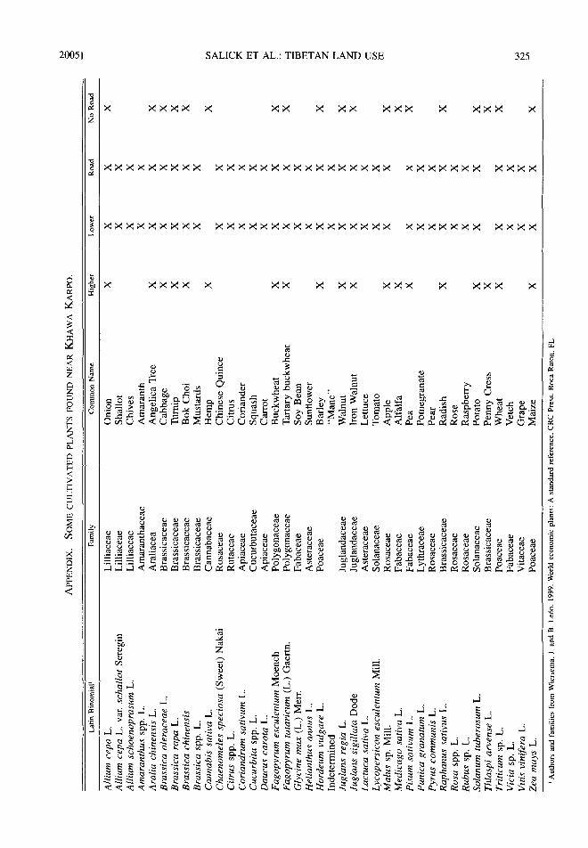
GARDENS AND TREES
In addition to fields, most households main- tain a small garden plot that often is adjacent to the house. Garden plots may contain a variety of vegetables, herbs, and medicines not found in fields (see the Appendix). Fruit and nut trees are sometimes incorporated into these gardens, but more commonly are found around the perimeter of fields, particularly in the lower villages. The most common tree crop is walnuts, which are eaten, used for oil, or sold. Orchards are uncom- mon, although villagers anticipate planting more fruit and nut trees on abandoned sloping fields and poorly irrigated areas.
ANIMAL HUSBANDRY
Pastoralism and animal husbandry are crucial aspects of Tibetan livelihoods. Aside from pro- viding the majority of protein and fat to the diet in the form of dairy and meat, yaks are symbolic of Tibetan tradition. Yaks are pastured near home or given fodder in the byre over winter. Small common property pastures near the vil- lages or crop fields with grain stubble are used for this purpose. Fodder is either grain stalks or forest leaves. In the summer, herds are taken to more distant pastures and alpine meadows where herders live in stone cabins. Pastures are more distant from lower villages (Fig. 6) since most

318 ECONOMIC BOTANY [VOL. 59
1800000
o~ 1600000 t ~
m
1400000
1200000 e .
:.F 1000000 e..
800000
600000 �9 Lower Fields 1 ~" [] Upper Fields E 400000
200000
<: 0 - - Total Barley Wheat Buckwheat Potato Walnut Maize
Fig. 4. Higher villages partition crops between upper fields (left: barley, wheat, buckwheat, potatoes) and lower fields (right: maize and walnuts). The high area is dominated by barley (48%), wheat (27%), and buck- wheat (22%). It is also where all of the home garden plots are located. The limited lower fields, which are approximately 200-300 meters below the village, are dominated by maize (84%).
summer pastures are in the mountains. Road ac- cess does not affect distance to pastures. Yaks also cycle nutrients from pastures, fodder, and bedding into compost and onto crop fields. Other common livestock include goats, sheep, pigs, chickens, ducks, and guinea fowl that scavenge and are fed with grain and cooked fodder.
NON-TIMBER FOREST PRODUCTS ( N T F P s )
Commercial collection of NTFPs is a regular and lucrative activity. Most villagers cite NTFP collection--principally Tricholoma spp. (matsu- take) and Cordyceps sinensis (caterpillar fun- gus) - -as their principle sources of income (Table
Fig, 5. Cash crops are more important in Tibetan villages with roads and at lower elevations. House- holds in lower villages have devoted significantly more area to cash crops than those in the higher villages. The same is true of households with roads compared to households without roads. Cash crops are apples, grapes, oranges, peaches, pears, pomegranates, and walnuts. Error bars denote standard error.
3). Getting NTFPs to market is difficult in villag- es without access to roads; however, villagers at lower elevations with road access must travel far- ther to collect NTFPs (Fig. 6; although sample sizes were not large enough to run statistics).
Tibetan medicine depends on the collection of medicinal plants that takes place in all habitats, although alpine meadows often were identified on PRA maps as particularly important. The Ti- betan doctors (collaborating authors) particularly stress the importance of this often-cryptic land use for traditional Tibetan livelihoods.
Fuelwood is used for heat and for cooking food and animal feed. Traditional stoves are in- efficient and villagers seldom have adopted solar or biogas cookers- - the i r reasons include culture concepts of pollution, use of dung in compost, technical malfunction, time, labor, smell, etc.
Leaves, twigs, and small branches are used for animal bedding, and are mixed with animal dung to make compost in the early spring. Fre- quent trips for fuelwood, fodder, and bedding make the distance to forests important to villag- ers (Fig. 6, see fuelwood).
SACRED SITES
A combination of Buddhism and BOn, the Ti- betan religion near Khawa Karpo attributes leg- ends and resident entities to many topographic and natural features-- including Khawa Karpo himself. It is the duty of local Tibetans to main- tain the precarious balance between beneficent

2005] SALICK ET AL.: TIBETAN LAND USE 319
Elevation Gradient Fig. 6. Distances to common property resources are greater for both lower villages and those with road
access (except for pastures with the latter). Common property resources include pastures, fuelwood, and non- timber forest products like fungi and Tibetan medicinal plants. Mean distances (bars with standard error whiskers) from villages to their respective common properties are calculated from G1S maps with reference to the PRA village maps. Numbers of common property samples (N) vary with commonness of the resource (e.g., lands with morels and cordyceps are uncommon, whereas forests with fuelwood are essential and ubiquitous) and are limited because villages have little if any access to these valuable resources, so we use only descriptive statistics.
and malevolent forces. To this end, Tibetans maintain the sanctity of the supernatural realm by observing an elevational boundary (ri-vgag) above which lies the sacred realm while the sec- ular lies below it. Although villagers use many resources from above the ri-vgag, generally log- ging is tolerated only below the boundary.
In addition, traditional Tibetan worldviews hold that features as disparate in scale as an en- tire mountain or a single stone contain a ritual significance. Habitats surrounding these features are variously protected. On a hillside in one vil- lage, for example, fodder collection is prohibit- ed, although gathering medicinal plants and mushrooms is tolerated. Beside the sacred alpine lake of the same village, however, not even the local Tibetan doctor may collect plants.
All villagers, regardless of village elevation or road access, identify numerous sacred sites on their PRA maps and during PDA mapping.
These sites include monasteries, stupas, shrines, retreats, mani piles, mountains, valleys, caves, rocks, lakes, rivers, waterfalls, forests, trees, pastures, and even vistas. To these Tibetans de- vote pilgrimage, pay homage, perambulate, and incessantly pray. The sacred is a genuine land use for Tibetans.
CHANGES IN LAND USE
Present land use reflects Tibetan tradition, ad- aptation, and change, which are hard to distin- guish. Change includes global change and polit- ical change. Some aspects of land use change - - although such is surprisingly subtle compared to drastic changes in other parts of China and the wor ld - -a re seen by comparing old photographs with the situation today, and some of these as- pects emerge in discussion with village elders shown these photos (Fig. 2). The photographs show there have been infrastructural changes,

320 ECONOMIC BOTANY [VOL. 59
TABLE 3. SOME NTFPs COLLECTED BY VILLAGERS NEAR KHAWA KARPO. THJS TABLE IS AN EXTREMELY SMALL BUT REPRESENTIVE SUBSET OF THE TOTAL SPECIES ACTUALLY COLLECTED.
Taxon Resource type Market price
Fungi Tricholoma spp. (Fries) Staude
Cordyceps sinensis (Berk.) Sacc.
Morchela spp. Dill. ex Pers.
Alpine Medicinal Plants Fritillaria spp. L. Saussurea spp. DC. Picrorhiza sp. Royle ex Benth.
Edible Plants and Lichen Pinus armandii Franch. Pteridium spp. Gled. ex Scop. Permelia sp. Aralia chinensis sp. L. Toona sinensis M. Roem. Orchids Cymbidium spp. Sw. Various other orchids
Matsutake, mycorrhizal mushroom exported to Japan
Caterpillar fungus, alpine fungus used in traditional Chinese and Tibetan medicines
Morels, forest, forest mushroom ex- ported abroad and used in tradi- tional Chinese medicine
Alpine plants used in traditional Chinese and Tibetan medicines
Pinenut (seed) sold in local markets Edible fern Edible lichen Edible leaves and shoots Edible leaves and shoots
Epiphytic orchid
200-1,200 yuan/kg ~ (price is extremely volatile)
10 yuan/stroma pair
600-110 yuan/kg dry weight 6 yuan/kg fresh (Zhang et al. 2000)
F. cirrhosa D. Don 6 yuan/kg (Zhang et al. 2000)
S. laniceps Hand.-Maxx. 2 yuan/kg
S. medusa Maxim. 1 yuan/kg Picrorhiza sp. 2 yuan/kg
(Zhang et al. 2000)
6-12 yuan/kg .5 yuan/kg 15 yuan/plate (restaurant) 15 yuan/plate (restaurant) 15 yuan/plate (restaurant)
250-1,000 yuan/plant 5-50 yuan/pIant
t 8.26 yuan = 1 U.S dollar
such as construction of roads, irrigation ditches, and houses. There also have been environmental changes, such as glacial retreat, tree line ad- vance, and aforestation, especially of hillsides.
Less obvious from the photographs, but con- sistently and adamantly discussed by elders, are changes in policy and tenure. Individual and mo- nastic ownership prevalent in the early 1900s and before gave way to nationalization in the 1950s, collectivization in the 1960s, the cultural revolution in the 1970s, decollectivization in the 1980s, and cultural and religious renaissance in the 1990s. Some changes that were begun in the 1950s continue now, such as production of roads, hydroelectrics, irrigation, and crops (par- ticularly commercial crops).
Aforestation is discussed by many village el- ders as being a result of government policies outlawing both steep hillside agriculture and pasture burning. Nearly all of the early photo- graphs show agriculture on steep hillsides above
villages, which are now abandoned (Fig. 2). Older villagers recall buckwheat, hemp, beans, opium, and other crops that are seldom seen to- day. Villagers offered several reasons for these changes in cultivation. Some cite the "Law of the People's Republic of China on Water and Soil Conservation." Passed in the 1991, this law prohibits cultivation of crops on hillsides with a slope of over 25 ~ . Other people point out that hillside agriculture yields less than irrigated val- leys. Aforestation was bolstered by the Chinese government 's "Grain-to-Green" plan, which provides economic incentives to replace hillside agriculture with trees and grasslands. Suppres- sion of pasture burning has caused the tree line to shift upward into alpine meadows and has re- duced pasture quantity and quality with an influx of fire intolerant plant species that are also un- palatable, indigestible, and/or poisonous.
Trees apparent in photos, however, do not in- dicate natural forests. Indeed, monoculture plan-
2005] SALICK ET AL.: TIBETAN LAND USE 321
tations, often of non-native Pinus spp. trees, are prevalent in areas where the government has paid villagers to convert cropland to forest. Old- er villagers in four out of six study sites report having to travel farther now than in their child- hoods to gather forest resources.
Government programs to increase irrigation have had a large impact on cropping and agricul- tural productivity (Fig. 2). All but one of the vil- lages surveyed used irrigation. Landslides, dis- putes, and road construction all have disrupted ir- rigation and caused field abandonment in the re- cent past. In one village, a burgeoning commerce in rice cultivation was abandoned after the con- struction of a new road, which limited its water supply; today rice is not found in the area. The government has actively promoted particular crops at various times; today these are grapes in the ir- rigated valleys and reforestation on the hillsides.
Change in agricultural technology has partic- ularly affected villages near roads. Pesticides are used and chemical fertilizers now compliment traditional oak/manure composts. Plastic sheet- ing to suppress weeds was introduced in the ear- ly 1980s to increase yields and reduce fallow time for corn and potatoes.
Changes in the collection of non-timber forest products have had a notable impact on the land use patterns near Khawa Karpo. Local residents note that Fritillaria cirrhosa and other medicinal plants, which are still collected but are worth less, were once the most sought after resources. Mush- room collection for commercial markets, by far the most lucrative wild-gathered resource, was un- known at the beginning of the century. Some vil- lages are limiting use of oak forests, which once provided mainly compost, fodder, and fuelwood, in order to manage a more productive habitat for matsutake mushrooms. Matsutake commoditiza- tion has changed land use in other ways too. Vil- lages with high matsutake productivity now charge outsiders collection fees for harvest rights.
All villagers surveyed report an increase in household ownership of livestock during the past century. Informants, however, cite dimin- ishing pasture quality due to over-grazing, and increasing dependence on fodder.
One of the less subtle differences between the images in Joseph Rock's historic photos and the present is the number of houses. Concluding that an increase in household numbers signifies an increase in village populations may be an un- warranted assumption, however. In remote vii-
lages, healthcare is still largely traditional, with high mortality, so that the Chinese government allows minority peoples to have two children rather than only one as elsewhere in China. And, as elsewhere in China, a great majority of chil- dren are male. Much of the male population leaves the villages for cash income, most com- monly on road crews and in military service. Thus, very large, traditional, Tibetan houses are seldom at capacity. House construction is also indicative of nascent tourism, another recent government initiative. Three study villages lo- cated on the major Tibetan pilgrimage route have embraced the potential influx of capital that tourists and pilgrims provide by constructing better trails, bridges, guesthouses, home addi- tions, and small shops. Indeed, tourism portends even greater change for the future.
DISCUSSION
Traditional Tibetan land use often is associ- ated with the harsh upper-elevation climes of the expansive Tibetan plateau, supporting little more than barley, buckwheat, and pastoralism. In con- trast, Tibetans on the eastern slopes of the Him- alayas have for millennia adapted to monsoonal rains and a steep elevational gradient (Salick et al. 2004). Khawa Karpo has one foot inside and one foot outside of Tibet: linguistically and cul- turally it is Tibetan, and yet politically, the east- ern half has been under Chinese sovereignty since the early eighteenth century (Aris 1992). Traditional Tibetan land use near Khawa Kar- po--agriculture, forestry, gathering, and pasto- ralism--is complex, with many trade-offs and much change over millennia. Specifically, Ti- betan land use is affected significantly by both elevation and by roads; moreover, change is ef- fected by these two variables.
Verticality and the concept of zonal comple- mentarity of resources (Mayer 1985; Murra 1968; Zimmerer 1999) is a much-discussed con- cept that, socio-political ramifications notwith- standing, explains much of Tibetan land use. Road access affects land use and impels change because of both markets (Jacoby 2000; Van De Walle 2002) and the spread of Han Chinese cul- ture and government (Lai 2002; PRC 2001). The relationships between roads and deforestation, which are important in many other studies (e.g., Chomitz and Gray 1996; Wilkie et al. 2000), are less of an issue in this area partially because many roads follow the dry river valleys that nev-
322 ECONOMIC BOTANY [VOL. 59
er have been forested. Livelihood trade-offs dominate, depending on where Tibetans l ive-- near or far from roads and at higher or lower elevations--like elsewhere in the world (Banik et al. 2004; Takasaki, Barham, and Coomes 2001). In the process of detailing these results, we establish other significant environmental, so- cio-economic, and policy determinants, many of which also have been discussed in the literature. Examples of these determinants are outside la- bor and household economics (Goldstein et al. 2003), irrigation, and non-bovine livestock hold- ings (Wilkes 2003); while others remain uncon- firmed, such as household and village popula- tions (Xu and Wilkes 2004).
Non-timber forest products (NTFPs) are and have always been essential in Tibetan livelihoods (Cooper 1871; Ward 1990), particularly so in the "Menri" or Medicine Mountains in which Kha- wa Karpo is the highest (Salick et al. submitted). Data from other studies within the prefecture (Xu and Wilkes 2004; Zhang, Wang, and Geng 2000) put the percentage of income earned from NTFPs at between 25% and 80% of total household in- comes, the most lucrative being Matsutake (He 2003; Yeh 2000; Yun 1997).
Change in Tibetan land use can be attributed to changes in environment, economics, and pol- icies as found in this study and elsewhere. Gla- cial retreat is tracked from repeat photographs of the area (Baker and Moseley submitted) as monitored elsewhere in the world (Hall and Fa- gre 2003; Luckman and Kavanagh 2000). In China, burgeoning markets (Chow 2004; Dreyer 2003; Qian and Wong 2000), tourism (Dreyer 2003; Weaver 2002), globalization (e.g., mush- rooms, FAO 2004; Yun, Hall, and Evans 1997), and medicines (Janes 2002) affect Tibetan re- gions as noted in this study. Chinese government policy, well documented elsewhere, is an obvi- ous factor driving change. Deforestation does not appear to be an issue near Khawa Karpo, unlike other studies from China (Albers, Ro- zelle, and Li 1998; Li et al. 1988; Richardson 1990; Shapiro 2001; Smil 1983; Winkler 1988). On the contrary, aforestation or increasing forest cover (Baker and Moseley submitted) is a result of less commercial timber extraction, little road access, traditional Tibetan sacred designations (Anderson et al. 2005; Salick et al. in press), and recent government bans on steep hillside culti- vation, forest extraction, and setting fires in nat-
ural forests (Luo, Xu, and Pei 2001; Zhang et al. 2000).
Looking forward at large government pro- grams designed to increase tourism and devel- opment in the Khawa Karpo region, we appeal for the integration of traditional Tibetan knowl- edge, culture, and land use in planning and im- plementation. While change is inevitable, en- lightened change is not. Tibetans have acted as environmental stewards of Khawa Karpo for millennia, and the future should hold a sus- tained, empowered, and influential role for them and their traditions.
ACKNOWLEDGMENTS We grateful for funding from the Ford Foundation for "In situ Eth-
nobotany Capacity Building and Policy Formation, Northwest Yunnan, China" and from The Nature Conservancy for "Ethnobotany Research and Conservation in the Meili Snow Mountains Conservation Area." Invaluable support was also provided by the Kunming Institute of Botany, the Center for Biodiversity and Indigenous Knowledge (CBIK), the In- ternational Center for Research on Agroforestry (ICRAF), the Three Par- allel Rivers Management Office, and the Shangri-La Alpine Botanical Garden. We sincerely would like to express our appreciation to the vil- lagers of the Khawa Karpo region for their unstinting help and bountiful hospitality.
LITERATURE CITED
Albers, H. J., S. D. Rozelle, and G. Li. 1998. China's forest under economic reform: Timber supplies, en- vironmental protection, and rural resource access. Contemporary Economic Policy 16(1):22-34.
AIdenderfer, M., and Y. Zhang. 2004. The prehistory of the Tibetan plateau to the seventh century A.D.: Perspectives and research from China and the West since 1950. Journal of World Prehistory 18(1 ): 1.
Anderson, D., J. Saliek, R. K. Moseley, and X. Ou. 2005. Conserving the Sacred Medicine Mountains: A vegetation analysis of Tibetan sacred sites in Northwest Yunnan. Biodiversity and Conservation On-line First.
Aris, M. 1992. Lamas, princes, and brigands: Joseph Rock's photographs of the Tibetan borderlands of China. China House Gallery, New York.
Ausubel, J. H. 1996. Can Technology Spare the Earth? American Scientist 84:166-178.
Baker, B. B., and R. K. Moseley. (Forthcoming) Changes in the Hengduan Mountains: Advancing treeline and retreating glaciers. Arctic, Antarctic, and Alpine Research.
Banik, P., C. Edmonds, N. Fuwa, S. P. Kam, V. L. Bagchi, and D. K. Bagehi. 2004. Natural resource endowments, subsistence agriculture, and poverty in the Chhotanagpur Plateau. Page 32. IRRI Dis- cussion Paper Series. International Rice Institute, Los Banos, Philippines.
Chomitz, K. M., and D. A. Gray. 1996. Roads, land use, and deforestation: A spatial model applied to

2005] SALICK ET AL.: TIBETAN LAND USE 323
Belize. The World Bank Economic Review 10(3): 487-512.
Chow, G. C. 2004. Economic reform and growth in China. Annals of Economics and Finance 5:127- 152.
Cooper, T. T. 1871. Travels of a pioneer of commerce in pigtails and petticoats: Or, an overland journey from China towards India. John Murray, London.
Cropper, M., J. Purl, and C. Griffiths. 2001. Pre- dicting the location of deforestation: The role of roads and protected areas in Thailand. Land Eco- nomics 77(2): 172-186.
Dreyer, J. T. 2003. Economic development in Tibet under the People's Republic of China. Journal of Contemporary China 12(36):411-430.
Ekvall, R. 1983. Fields on the hoof: Nexus of Tibetan nomadic pastoralism. Waveland Press, Inc., Pros- pect Heights, IL.
ESR|. 1992-1999. Arcview Gis 3.2, Redlands, CA. �9 2002. Arcpad, Redlands, CA. �9 2004. Arcmap 9.0, Redlands, CA.
FAO (Food and Agriculture Organization of the United Nations)�9 2004. Wild edible fungi. A global overview of their use and importance to people. Food and Agriculture Organization of the United Nations.
Forman, R. T. T. 1998. Roads and their major eco- logical effects. Annual Review of Ecology and Sys- tematics 29:207-231.
Goldstein, M. C. 1973. The circulation of estates in Tibet: Reincarnation, land and politics. Journal of Asian Studies 32(5):445-455.
, and C. M. Beall. 2002. Changing pattern of Tibetan nomadic pastoralism. Pages 131-150 in W. R. Leonard and M. H. Crawford, eds., Human bi- ology of pastoral populations. Cambridge Univer- sity Press, Cambridge, UK.
, B. Jiao, C. M. Beall, and P. Tsering. 2003. Development and change in rural Tibet: Problems and adaptations. Asian Survey 43(5):758-779.
Grau, H. R., T. M. Aide, J. K. Zimmerman, J. R. Thomlinson, E. Helmer, and X. Zou. 2003. The ecological consequences of socioeconomic and land-use changes in postagriculture Puerto Rico. BioScience 53(12):1159-1168.
Guo, J. 2000. A mountain of nature, also a mountain of divinity: Indigenous knowledge about the space of Mt. Khabadkarpo. Pages 230-239 in J. Xu, ed., Links between cultures and biodiversity: Proceed- ings of the cultures and biodiversity congress 2000. Yunnan Science and Technology Press, Yunnan, China.
Hail, M. H. P., and D. B. Fagre. 2003. Modeled cli- mate-induced glacier change in Glacier National Park, 1850-2100. BioScience 53(2):131-140.
Hamlin, C. C., and J. Salick. 2003. Yanesha agricul- ture in the Upper Peruvian Amazon: Persistence
and change fifteen years down the 'road.' Econom- ic Botany 57(2): 163-180.
lie, J. 2003. Cross-scale institutional linkages of com- mercial matsutake mushroom management and marketing: A preliminary study of an NTFP in Zhongdian County, Yunnan. Pages 193-197 in J. Xu and S. Mikesell, eds., Landscapes of diversity: Indigenous knowledge, sustainable livelihoods and resource governance in montane mainland South- east Asia. Yunnan Science and Technology Press, Lijiang, China.
Jacoby, H. G. 2000. Access to markets and the ben- efits of rural roads. The Economic Journal 110(465):713-737.
Janes, C. R. 2002. Buddhism, science and market: The globalisation of Tibetan medicine. Anthropol- ogy and Medicine 9(3):267-289.
Lai, H. H. 2002. China's western development pro- gram: Its rationale, implementation, and prospects. Modern China 28(4):432-466.
Lambin, E. F., B. L. Turner, H. J. Geist, S. B. Ag- bola, A. Angelsen, J. W. Bruce, O. T. Coomes, R. Dirzo, G. Fischer, C. Folke, P. S. George, K. Homewood, J. Imbernon, R. Leemans, X. Li, E. F. Moran, M. Mortimore, P. S. Ramakrishnan, J. F. Richards, H. Skanes, W. Steffen, G. D. Stone, U. Svedin, T. A. Veldkamp, C. Vogel, and J. Xu. 2001. The cause of land-use and land-cover change: Moving beyond the myths. Global Envi- ronmental Change 11:261-269.
- - , H. J. Geist, and E. Lepers. 2003. Dynamics of land-use and land-cover change in tropical re- gions. Annual Review of Environment and Re- sources 28:205-241.
Li, J., F. Kong, N. He, and L. Ross. 1988. Price and policy: The keys to revamping China's forestry re- sources. Pages 205-245 in R. Repetto and M. Gil- lis, eds., Public policies and the misuse of forest resources. Cambridge University Press, Cambridge, UK.
Litzinger, R. 2004. The mobilization of "nature": Perspectives from Northwest Yunnan. The China Quarterly 178:488-504.
Luckman, B., and T. Kavanagh. 2000. Impact of cli- mate fluctuations on mountain environments in the Canadian Rockies. Ambio 29:371-380.
Luo, P., J. C. Xu, and S. J. Pei. 2001. A discussion on the conflicts between grassland animal husband- ry and nature conservation in Northwest Yunnan. Grasslands of China 23:1-5.
Maikhuri, R. K., K. S. Rao, and R. L. Semwal. 2001. Changing scenario of Himalayan agroeco- systems: Loss of agrobiodiversity, an indicator of environmental change in central Himalaya, India. The Environmentalist 21:23-39.
Mayer, E. 1985. Production zones. Pages 45-84 in S. Masuda, I. Shimada, and C. Morris, eds., Andean

324 ECONOMIC BOTANY [VOL. 59
ecology and civilization. University of Tokyo Press, Tokyo, Japan.
Mittermeier, R. A., N. Meyers, J. B. Thomsen, G. A. B. d. Fonseca, and S. Olivieri. 1998. Biodi- versity hotspots and major tropical wilderness ar- eas. Conservation Biology 12:516-520.
Moseley, R. K. 2003. Kawagebo Snow Mountains: Sacred natural sites case study. Fifth World Parks Congress, Durban, South Africa.
Murra, J. V. 1968. An Aymara Kingdom in 1567. Ethnohistory 15(2):I 15-151.
Ning, W., and C. Richard. 1999. The privatization of rangeland and its impacts on pastoral dynamics in the Hindu-Kush Himalaya: The case of Western Sichuan, China. International Rangeland Congress, Townsville, Australia.
PRC (Peoples Republic of China). 2001. Tibet's march toward modernization. Information Office of the State Council of the Peoples Republic of China, Beijing. Available at http://www.china.org.cn/ ewhite/20011108/index.htm.
Qian, Z., and T.-C. Wong. 2000. The rising urban poverty: A dilemma of market reforms in China. Journal of Contemporary China 9(23):113-125.
Richardson, S. D. 1990. Forests and forestry in China: Changing patterns of resource development. Island Press, Covelo, CA.
Saliek, J., A. Amend, B. Gunn, W. Law, H. Schmidt. (n.d.). Tibetan medicine plurality and market threats. Submitted to Economic Botany.
, - - , D. Anderson, K. Hoffmeister, B. Gunn and Z. D. Fang. (n.d.). Tibetan Sacred Sites Conserve Old Growth Trees in the Eastern Hima- layas. Biodiversity and Conservation, in press.
, D. Anderson, J. Woo, R. Sherman, C. Nor- bu, A-Na, and S. Dorje. 2004. Tibetan ethnobot- any and gradient analyses, Menri (Medicine Moun- tains), Eastern Himalayas. Millennium Ecosystem Assessment, Alexandria, Egypt. Available at http:/Iwww.millenniumassessment.org/documents/ bridging/papers/salick.j an.pdf
Shannon, C. E., and W. Weaver. 1949. The mathe- matical theory of communication. University of Il- linois Press, Urbana, IL.
Shapiro, J. 2001. Mao's war against nature: Politics and the environment in revolutionary China. Cam- bridge University Press, Cambridge, UK.
Sinclair, J., and L. Ham. 2000. Household adaptive strategies: Shaping livelihood security in the West- ern Himalayas. Canadian Journal of Development Studies 21:89-112.
Stall, V. 1983. Deforestation in China. Ambio 12(5): 226-23 I.
SPSS. 2003. SPSS 12.0 for Windows, Chicago, IL. Takasaki, Y., B. L. Barbara, and O. T. Coomes.
2001. Risk coping strategies in tropical forests: Floods, asset inequality, and natural resource ex- traction. NEUDC, Boston University, Boston, MA.
Van De Walle, D. 2002. Choosing rural road invest- ments to help reduce poverty. World Development 30(4):575-589.
Wang, F. Y., S. Tang, Y. Sui, and X. Wang. 2003. Toward intelligent transportation systems for the 2008 Olympics. Intelligent Systems, IEEE 18(6): 8-11.
Ward, F. K. 1990. Plant hunters in paradise. Page 179 (of section written in 1938) in E K. Ward, ed., Hi- malayan enchantment: An anthology. Serindia Pub- lications, London, UK.
Weaver, D. 2002. Asian ecotourism: Patterns and themes. Tourism Geographies 4(2): 153-172.
Wilkes, A. 2003. Using the sustainable livelihoods framework to understand agro-pastoralist liveli- hoods in Northwest Yunnan. Center for Biodiver- sity and Indigenous Knowledge, Kunming, China.
Wilkie, D., E. Shaw, F. Rotberg, G. Morelli, and P. Auzel, 2000. Roads, development and conservation in the Congo Basin. Conservation Biology 14(6): 1614.
Windle, J., and R. A. Cramb. 1997. Remoteness and rural development: Economic impacts of rural roads on upland farmers in Sarawak, Malaysia. Asia Pacific Viewpoint 38(1):37-53.
Winkler, D. 1988. Major threats to Tibetan forest eco- systems and strategies for forest biodiversity. Pages 62-67 in WWF China Programme International Workshop, Tibet's Biodiversity: Conservation and Management. China Forestry Publishing House, Beijing, China.
Xu, J., and A. Wilkes. 2004. Biodiversity impact analysis in Northwest Yunnan, Southwest China. Biodiversity and Conservation 13:959-983.
Yeh, E. 2000. Forest claims, conflicts and commodi- fication: The political ecology of Tibetan mush- room-harvesting in Yunnan Province, China. China Quarterly 161:264-278.
Yun, W., I. R. Hall, and L. A Evans. 1997. Ecto- mycorrhizal fungi with edible fruiting bodies: Tri- choloma matsutake and related fungi. Economic Botany 51(3):311-327.
Zhang, J., W. Wang, and Y. Geng. 2000. A case study on the exploitation and management of NTFP in Shirong Village of Xiaruo Township in Deqin County. Pages 58-67 in The International Seminar on Non-Timber Forest Product. Yunnan University Press, Simao, China.
Zhang, P., G. Shao, G. Zhao, D. C. L. Master, G. R. Parker, D. J. John B, and Q. Li. 2000. China's forest policy for the 21st century. Science 23(6): 2135-2136.
Zhou, G. 2001. Area calculation for polygon, Fukuoka City, Japan.
Zimmerer, K. S. 1999. Overlapping patchworks of mountain agriculture in Peru and Bolivia: Toward a regional-global landscape model. Human Ecolo- gy 27(l):135-165.
2005] SALICK ET AL.: TIBETAN LAND USE 325
s
<
<
<
<
Z Z C~ z �9
Z <
c~ r~
< _>
Z
<
o
~ ~ O o ~
�9 ~ �9 ~ . ~ : ~ , ~ ~ -~ ~ .~ ~ , i ~ .
~ . ~ , - . , , ~ ~, r ~ ",~,
~.~ ~ ~ ~ ~
-~ ~ ' ~ ~ ;~ ~ ~ - , ~ . ~ ~
d
u
<
E =o o
-u
-4
E
E