tide gauge instrument information, data processing
TRANSCRIPT
NTSLF Annual Report 2004 Instrument documentation
- 3 -
Tide gauge instrument information, data processing procedures and gauge location

NTSLF Annual Report 2004 Instrument documentation
- 4 -
Instrument documentation Bubbler Tide Gauge The full tide bubbler system normally consists of two independent measuring systems. The pressure points are mounted approx 1m below Admiralty Chart Datum ACD so that negative surges may be recorded. The pressure points which you can see mounted underwater in the photograph are similar in appearance to an inverted bucket with a copper nozzle mounted on the side. This nozzle is the actual measuring point. A low flow of dry air (normally 7ml/min) is fed down an air tube to the top of the pressure point. When the air pressure in the air line equals the pressure exerted by the column of water above it, then the excess air is released as bubbles through the copper nozzle. This means that the pressure in the air line is proportional to the weight of the water column.
Mid-tide bubbler The operation of the mid tide bubbler is similar to that of the full tide system, except that the measuring point is mounted at the mid tide height. That means that the pressure point is only immersed for half of the tidal cycle. The reason for this, is that when the measuring point is exposed as in the photograph below it can be accurately levelled into the geodetic network. Once this is accomplished the full tide pressure points can be fitted to match the tidal curve produced by the mid tide pressure point, thereby connecting them to the geodetic network.

NTSLF Annual Report 2004 Instrument documentation
- 5 -
Pressure Transducer These are differential transducers contained in a watertight housing. The reference port is vented to atmosphere via the power supply and signal cable tube, while the measuring port of the transducer is connected to a copper outlet nozzle on the top of the transducer housing. The copper nozzle, transducer measuring port and connecting tube are filled with oil so the pressure is transmitted to the crystal element via the oil, thus keeping the transducer components free from the effects of the saltwater.
Munro float gauge The Munro gauge measures sea level by means of a float in a stilling well. The float is about 45cm diameter - the large diameter reduces inevitable errors in buoyancy due to friction of the gearing and small changes in the length of float wire. This wire is coiled round a drum on the end of the gauge and another drum contains the counter balance wire. The drum is geared to a slotted tape attached to a pen carriage which traces the tide curve on the chart during the rise and fall of the tide. A precision potentiometer is attached to the gauge to provide an input to the data logger.
Wellhead float gauge The Wellhead gauge measures the sea level by means of a float in a stilling well. The float is usually of a smaller diameter than that used on a Munro gauge (about 45cm diameter), and has a counterweight attached to a smaller diameter pulley than that of the float so it is not immersed in the sea when the float rises. The Wellhead unit does not produce a chart but does give a readout of the height. It is interfaced to the data logger via a precision potentiometer.

NTSLF Annual Report 2004 Data Processing
- 6 -
Data Processing The data are collected on demand each week at Proudman Oceanographic Laboratory. The weekly files are then screened using our in-house visualisation package, Edteva. Suspect values are flagged and short gaps are interpolated where the accuracy is deemed not to be affected. The weekly files are then concatenated into monthly files, with the residual added, and these are then edited so that all values fall on the quarter hour and gaps are filled in with null values and marked with an 'N' flag. The files are placed on the web for users to download. Statistics are produced monthly again using Edteva. The last stage is where the monthly files are concatenated into yearly files and the metadata for the yearly files are then banked in a database. Calculating Statistics in Edteva There are essentially four types of summary information determined by Edteva: a history of when the tide gauge has been in operation (“history”), monthly extremes (“extremes”), monthly extreme surges (“surges”) and monthly and daily mean sea level (“MSL”). Gaps greater than 4.1 hours in the primary channel are registered as gaps in the history. Extremes are the maximum and minimum calculated over all sampled data during the month. This excludes any interpolated data but may include rapidly sampled data. Extreme surges (residuals) are calculated in the same way from tidal residuals. Tidal residuals are defined to be the measured water level minus the predicted tide. The predictions derive from the database of tidal constants maintained by POL’s Applications Group (as defined at the time of the calculation) for the ports of UK and elsewhere. Mean Sea Level is calculated from a filter working on quarter-hourly values derived from one or more cubic splines applied to the raw data. The filter is a convolution of Vassie’s 03B filter which converts 15-minute data to hourly values and Doodson’s X0 filter. Splines are not applied across gaps as defined above. Shortish gaps can therefore lead to the loss of a day of output data (the half length of the filter is 91 and a day is 96 samples). Provided there are some daily (@12:00Z) values these are then averaged to provide the monthly value.

NTSLF Annual Report 2004 Tide Gauge Locations
- 7 -
Location of Tide Gauges Around the U.K.
Aberdeen
Ullapool
Wick
Moray Firth
Lerwick
Kinlochbervie
LeithMillport
North Shields
WhitbyWorkington
Portpatrick
Heysham
Immingham
Cromer
Lowestoft
HarwichSheerness
Dover
NewhavenWeymouth
Devonport
Jersey
St. Mary’s
Newlyn
Bournemouth
HinkleyAvonmouth
Newport
IlfracombeMumbles
Milford HavenFishguard
Barmouth
Holyhead Llandudno
Port Erin
Liverpool
Bangor
Portrush
Port Ellen
Tobermory
Stornoway
Portsmouth
Felixstowe

NTSLF Annual Report 2004 Site Information
- 8 -
Aberdeen Tide Gauge Latitude: 57° 08' 38.5" N Longitude: 02° 04' 48.8" W Grid Reference: NJ 9524 0591 Instrument type: Data acquisition system with two full tide bubbler gauges installed. Site of Gauge: The tide gauge building is located on Waterloo Quay and the pressure points are located in the South West corner of Telford Dock.
©Crown copyright. All rights reserved NERC 100017897 2004
Tide gauge location
Aerial view of site

NTSLF Annual Report 2004 Site Information
- 9 -
Avonmouth Tide Gauge Latitude: 51° 30' 27.9" N Longitude: 02° 42' 45.9" W Grid Reference: ST 5063 7900 Instrument type: Data acquisition system with dual underwater pressure transducers. Site of Gauge: The tide gauge building is located on land between the disused oil jetty and the fuel storage depot, with the measuring points being located at the seaward end of the jetty.
©Crown copyright. All rights reserved NERC 100017897 2004

NTSLF Annual Report 2004 Site Information
- 10 -
Bangor Tide Gauge Latitude: 54° 39' 53.1" N Longitude: 05° 40' 10.1" W Grid Reference: NW 6340 3620 Instrument type: Data acquisition system with two full tide and a mid-tide bubbler gauge installed. Site of Gauge: The tide gauge building and pressure points are located on Central Pier at Bangor Marina. The pressure points are on the seaward side of the open pier directly beneath the tide gauge building.
©Ordnance Survey of Northern Ireland 2004

NTSLF Annual Report 2004 Site Information
- 11 -
Barmouth Tide Gauge Latitude: 52° 43' 09.6" N Longitude: 04° 02' 42.1" W Grid Reference: SH 6197 1548 Instrument type: Data acquisition system with two full tide bubbler gauges installed. Site of Gauge: The tide gauge cabinet is located in the toll booth on the north end of Barmouth railway bridge which crosses the river Mawddach. The pressure points are attached to the first leg of the railway bridge in the deep channel.
©Crown copyright. All rights reserved NERC 100017897 2004

NTSLF Annual Report 2004 Site Information
- 12 -
Bournemouth Tide Gauge Latitude: 50° 42' 51.6" N Longitude: 01° 52' 29.5" W Grid Reference: SZ 0893 9053 Instrument type: Data acquisition system with two full tide and a mid-tide bubbler gauge installed. Site of Gauge: The tide gauge equipment is located in the pier electrical room at the west side of the South Pier. The measuring points are mounted directly below on one of the pier legs.
©Crown copyright. All rights reserved NERC 100017897 2004

NTSLF Annual Report 2004 Site Information
- 13 -
Cromer Tide Gauge Latitude: 52° 56' 03.1" N Longitude: 01° 18' 05.9" E Grid Reference: TG 2198 4253 Instrument type: Data acquisition system with two full tide and a mid-tide bubbler gauge installed. Site of Gauge: The tide gauge cabinet is located within Cromer lifeboat station, with the pressure points attached to a leg of the lifeboat slipway.
©Crown copyright. All rights reserved NERC100017897 2004

NTSLF Annual Report 2004 Site Information
- 14 -
Devonport Tide Gauge Latitude: 50° 22' 06.2" N Longitude: 04° 11' 06.9" W Grid Reference: SX 4469 5434 Instrument type: Data acquisition system with two full tide bubbler gauges installed. Site of Gauge: The tide gauge building is situated on No. 1 Jetty in Devonport Royal Naval base. The pressure points are attached to the stilling well beneath the building.
©Crown copyright. All rights reserved NERC 100017897 2004

NTSLF Annual Report 2004 Site Information
- 15 -
Dover Tide Gauge Latitude: 51° 06' 51.8" N Longitude: 01° 19' 21.1" E Grid Reference: TR 3264 4026 Instrument type: Data acquisition system with two full tide bubbler gauges installed. Site of Gauge: The tide gauge building is at the seaward end of Prince of Wales Pier, Western Dock, just before the lighthouse. The pressure points are attached to the stilling well.
©Crown copyright. All rights reserved NERC 100017897 2004

NTSLF Annual Report 2004 Site Information
- 16 -
Felixstowe Tide Gauge Latitude: 51° 57' 27.7" N Longitude: 01° 20' 47.6" E Grid Reference: TM 3003 3409 Instrument type: Data acquisition system with two full tide bubbler gauges installed. Site of Gauge: The tide gauge building and pressure points are located on Felixstowe pier. The equipment is located on the landward end and the pressure points are located in deep water at the seaward end.
©Crown copyright. All rights reserved NERC 100017897 2004

NTSLF Annual Report 2004 Site Information
- 17 -
Fishguard Tide Gauge Latitude: 52° 00' 47.6" N Longitude: 04° 59' 01.5" W Grid Reference: SM 9534 3918 Instrument type: Data acquisition system with two full tide bubbler gauges installed. Site of Gauge: The tide gauge building is located on Fishguard Quay adjacent to the RNLI station, and the pressure points are located approximately 10m from the end of the quay.
©Crown copyright. All rights reserved NERC 100017897 2004

NTSLF Annual Report 2004 Site Information
- 18 -
Harwich Tide Gauge Latitude: 51° 56' 52.8" N Longitude: 01° 17' 31.4" E Grid Reference: TM 2634 3284 Instrument type: Data acquisition system with two full tide and a mid-tide bubbler gauge installed. Site of Gauge: The tide gauge cabinet is located on the seaward end of Harwich Haven Authority jetty. The pressure points are directly below the cabinet.

NTSLF Annual Report 2004 Site Information
- 19 -
Heysham Tide Gauge Latitude: 54° 01' 54.6" N Longitude: 02° 55' 12.9" W Grid Reference: SD 3982 5993 Instrument type: Data acquisition system with two full tide bubbler gauges. Site of Gauge: The tide gauge building is located on the south side of the entrance to Heysham harbour.
©Crown copyright. All rights reserved NERC 100017897 2004

NTSLF Annual Report 2004 Site Information
- 20 -
Hinkley Point Tide Gauge Latitude: 51° 12' 54.9” N Longitude: 03° 08' 04.1” W Grid Reference: ST 2086 4684 Instrument type: Dataring system with dual underwater pressure transducers. Site of Gauge: The tide gauge building is located in the Hinkley Point “A” station. The transducers are located in underwater vented chambers, suspended from a steel pole attached to the structure of the water intake tower, some 400m offshore.
©Crown copyright. All rights reserved NERC 100017897 2004

NTSLF Annual Report 2004 Site Information
- 21 -
Holyhead Tide Gauge Latitude: 53° 18' 50.2" N Longitude: 04° 37' 13.5" W Grid Reference: SH 2553 8287 Instrument type: Data acquisition system with a full tide and a mid-tide bubbler gauge and a back-up Munro float gauge installed. Wind speed and wind direction are also recorded. Site of Gauge: The tide gauge building, pressure points and stilling well are situated on Salt Island jetty, close to the old harbour lighthouse.
©Crown copyright. All rights reserved NERC 100017897 2004

NTSLF Annual Report 2004 Site Information
- 22 -
Ilfracombe Tide Gauge Latitude: 51° 12' 40.1" N Longitude: 04° 06' 44.6" W Grid Reference: SS 5255 4789 Instrument type: Data acquisition system with two full tide and a mid-tide bubbler gauge installed. Site of Gauge: The tide gauge building is located in the North West corner of the car park, east of Lantern Hill. The pressure points are located on the seaward side of Ilfracombe pier at the harbour entrance.
©Crown copyright. All rights reserved NERC 100017897 2004

NTSLF Annual Report 2004 Site Information
- 23 -
Immingham Tide Gauge Latitude: 53° 37' 49.5" N Longitude: 00° 11' 15.1" W Grid Reference: TA 1995 1640 Instrument type: Data acquisition system with two full tide bubbler gauges installed. Site of Gauge: The tide gauge building is east of the lock gates at the entrance to Immingham Docks. The pressure points are fixed to a leg of the lead-in jetty on the east side of the entrance to Immingham Docks.
©Crown copyright. All rights reserved NERC 100017897 2004

NTSLF Annual Report 2004 Site Information
- 24 -
Port Erin (Isle of Man) Tide Gauge Latitude: 54° 05' 06.8" N Longitude: 04° 46' 05.0" W Grid Reference: SC 1904 6902 Instrument type: Data acquisition system with two full tide and a mid-tide bubbler gauge installed. Site of Gauge: The tide gauge cabinet is located in Port Erin lifeboat station and the pressure points are mounted close to the end of the lifeboat slipway. The mid-tide pressure point is mounted on steelwork attached to a concrete leg of the boathouse.
©Isle of Man Harbours 2004

NTSLF Annual Report 2004 Site Information
- 25 -
Port Ellen (Isle of Islay) Tide Gauge Latitude: 55° 37' 39.3" N Longitude: 06° 11' 23.7" W Grid Reference: NR 3636 4508 Instrument type: Data acquisition system with two full tide bubbler gauges installed. Site of Gauge: The tide gauge cabinet is located in the Caledonian MacBrayne storeroom next to Port Ellen ferry terminal. The pressure points are located south west of the ferry terminal offices.
©Crown copyright. All rights reserved NERC 100017897 2004

NTSLF Annual Report 2004 Site Information
- 26 -
St. Helier (Jersey) Tide Gauge Latitude: 49° 11' 00" N Longitude: 02° 07' 00 " W Grid Reference: 13/11 6466 4763 Instrument type: Data acquisition system with two full tide and a mid-tide bubbler gauge installed. Site of Gauge: The tide gauge building is located on Victoria Pier, St. Helier, adjacent to the Port Control building. The pressure points are located on the inside wall of the pier, 2m from the tide gauge building.
©States of Jersey 2004

NTSLF Annual Report 2004 Site Information
- 27 -
Kinlochbervie Tide Gauge Latitude: 58° 27' 24.1" N Longitude: 05° 03' 00.8" W Grid Reference: NC 2213 5609 Instrument type: Dataring system with two full tide bubbler gauges installed. Site of Gauge: The tide gauge cabinet is located in the ice plant, on the pier. The pressure points are mounted on a leg of the jetty beneath the ice plant.
©Crown copyright. All rights reserved NERC 100017897 2004

NTSLF Annual Report 2004 Site Information
- 28 -
Leith Tide Gauge Latitude: 55° 59' 23.4"N Longitude: 03° 10' 54.1"E Grid Reference: NT 2638 7806 Instrument type: Data acquisition system with a full tide bubbler gauge and a potentiometer connected to a Munro float gauge installed. Site of Gauge: The tide gauge building and pressure points are located on the lead-in jetty, east of the entrance to Leith docks.
©Crown copyright. All rights reserved NERC 100017897 2004

NTSLF Annual Report 2004 Site Information
- 29 -
Lerwick Tide Gauge Latitude: 60° 09' 14.5" N Longitude: 01° 08' 25.1" W Grid Reference: HU 4783 4137 Instrument type: Data acquisition system with two full tide and a mid-tide bubbler gauge installed. Site of Gauge: The tide gauge building and measuring points are located on the inner wall at breakwater entrance to the small boat harbour, south of Victoria Pier, Lerwick.
©Crown copyright. All rights reserved NERC 100017897 2004

NTSLF Annual Report 2004 Site Information
- 30 -
Liverpool Tide Gauge Latitude: 53° 26' 58.9" N Longitude: 03° 01' 05.3" W Grid Reference: SJ 3248 9525 Instrument type: Data acquisition system with two full tide and a mid-tide bubbler gauge installed. Wind speed and wind direction also recorded up until June 2004. Site of Gauge: The Tide Gauge is located within the old Lock Keepers office at the entrance to Gladstone Dock. The pressure points are located on the seaward side of Gladstone Dock. The wind speed and direction instruments are mounted at the top of the light tower located next to the tide gauge building.
©Crown copyright. All rights reserved NERC 100017897 2004

NTSLF Annual Report 2004 Site Information
- 31 -
Llandudno Tide Gauge Latitude: 53° 19' 54.0" N Longitude: 03° 49' 30.8" W Grid Reference: SH 7855 8319 Instrument type: Data acquisition system with two full tide and a mid-tide bubbler gauge installed. Site of Gauge: The tide gauge building is located on the sub-platform under the pavilion at the seaward end of Llandudno pier. The pressure points are located on a leg of the pier below the tide gauge building.
©Crown copyright. All rights reserved NERC 100017897 2004

NTSLF Annual Report 2004 Site Information
- 32 -
Lowestoft Tide Gauge Latitude: 52° 28' 23.1" N Longitude: 01° 45' 00.9" E Grid Reference: TM 5479 9274 Instrument type: Data acquisition system with two full tide and a mid-tide bubbler gauge installed. Site of Gauge: The tide gauge building is situated east of the Harbour Master's Office with the pressure points located on the quay wall, east of the tide gauge building.
©Crown copyright. All rights reserved NERC 100017897 2004

NTSLF Annual Report 2004 Site Information
- 33 -
Milford Haven Tide Gauge Latitude: 51° 42' 26.6" N Longitude: 05° 03' 06.4" W Grid Reference: SM 8924 0537 Instrument type: Data acquisition system with two full tide bubbler gauges installed. Site of Gauge: The tide gauge is located in the store room at the shore end of Milford Haven Port Authority jetty. The pressure points are mounted at the seaward end of the jetty.
©Crown copyright. All rights reserved NERC 100017897 2004

NTSLF Annual Report 2004 Site Information
- 34 -
Millport Tide Gauge Latitude: 55° 44' 59.3" N Longitude: 04° 54' 22.8" W Grid Reference: NS 1769 5454 Instrument type: Data acquisition system with two full tide bubbler gauges installed. Site of Gauge: The tide gauge is housed in a storeroom at the shore end of the University Marine Biological Station pier. The pressure points are mounted at the seaward end of the pier.
©Crown copyright. All rights reserved NERC 100017897 2004

NTSLF Annual Report 2004 Site Information
- 35 -
Moray Firth Tide Gauge Latitude: 57° 35' 55.3" N Longitude: 04° 00' 08.0" W Grid Reference: NH 8040 5829 Instrument type: Data acquisition system with two full tide and a mid-tide bubbler gauge installed. Site of Gauge: The tide gauge building is sited beneath the light tower at McDermott Base, Ardesier on the south side of the entrance to Whiteness Bay. The pressure points are mounted on the sheet pile wall, north east of the tide gauge building.
©Crown copyright. All rights reserved NERC 100017897 2004
NTSLF Annual Report 2004 Site Information
- 36 -
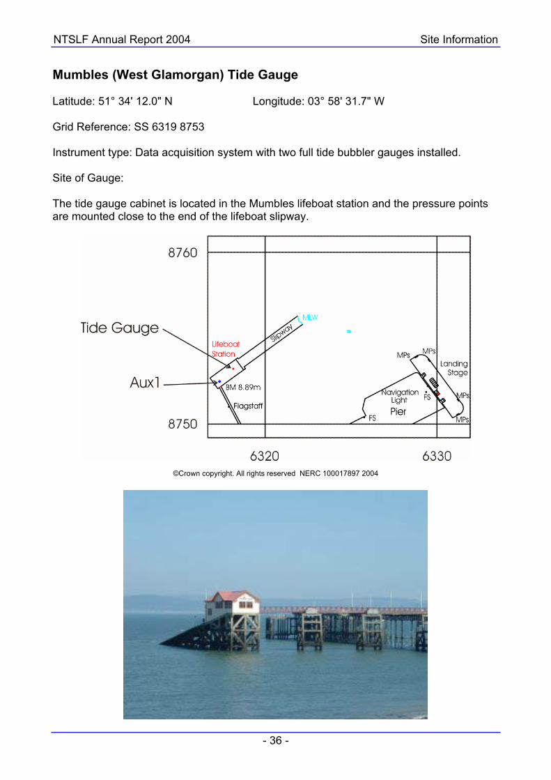
Mumbles (West Glamorgan) Tide Gauge Latitude: 51° 34' 12.0" N Longitude: 03° 58' 31.7" W Grid Reference: SS 6319 8753 Instrument type: Data acquisition system with two full tide bubbler gauges installed. Site of Gauge: The tide gauge cabinet is located in the Mumbles lifeboat station and the pressure points are mounted close to the end of the lifeboat slipway.
©Crown copyright. All rights reserved NERC 100017897 2004

NTSLF Annual Report 2004 Site Information
- 37 -
Newlyn Tide Gauge Latitude: 50° 06' 10.8" N Longitude: 05° 32' 33.9" W Grid Reference: SW 4676 2856 Instrument type: Data acquisition system with a full tide, a mid-tide bubbler gauge and a potentiometer attached to a Munro float gauge installed. Site of Gauge: The Tidal Observatory is located at the end of South Pier, Newlyn, next to the lighthouse. The pressure points are located on the seaward side of the pier, behind the lighthouse.
©Crown copyright. All rights reserved NERC 100017897 2004

NTSLF Annual Report 2004 Site Information
- 38 -
Newhaven (Sussex) Tide Gauge Latitude: 50° 46' 54.4" N Longitude: 00° 03' 25.3" E Grid Reference: TQ 4511 0004 Instrument type: Data acquisition system with two full tide bubbler gauges installed. Site of Gauge: The tide gauge is located within the Port Control building on West Pier, Newhaven, and the pressure points are located on the pier wall, south east of the Port Control building. The anemometer and wind vane are located on the signals mast.
©Crown copyright. All rights reserved NERC 100017897 2004
NTSLF Annual Report 2004 Site Information
- 39 -
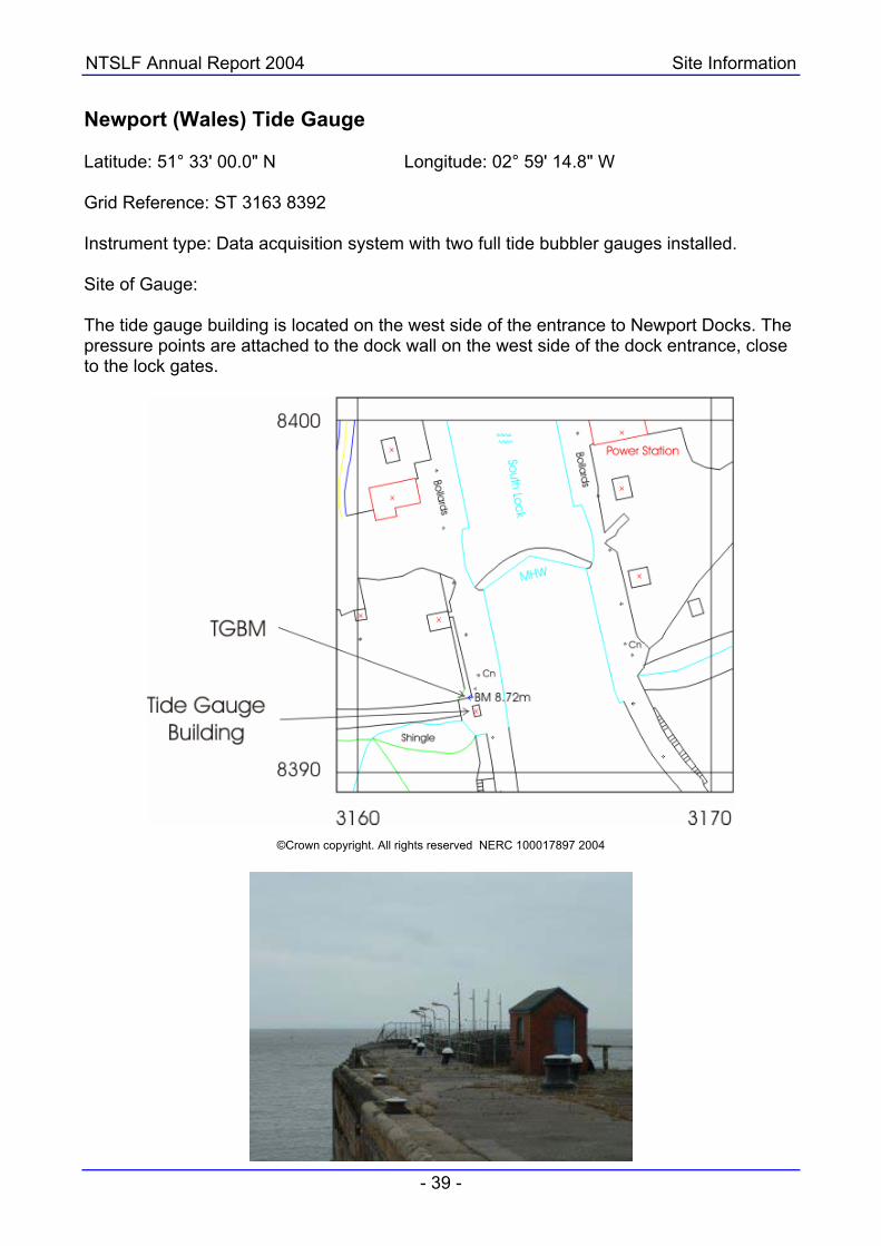
Newport (Wales) Tide Gauge Latitude: 51° 33' 00.0" N Longitude: 02° 59' 14.8" W Grid Reference: ST 3163 8392 Instrument type: Data acquisition system with two full tide bubbler gauges installed. Site of Gauge: The tide gauge building is located on the west side of the entrance to Newport Docks. The pressure points are attached to the dock wall on the west side of the dock entrance, close to the lock gates.
©Crown copyright. All rights reserved NERC 100017897 2004

NTSLF Annual Report 2004 Site Information
- 40 -
North Shields (Tyne and Wear) Tide Gauge Latitude: 55° 00' 26.8" N Longitude: 01°26' 23.2" W Grid Reference: NZ 3593 6824 Instrument type: Data acquisition system with potentiometers attached to the Munro float gauge and the Wellhead float gauge installed. Site of Gauge: The tide gauge building is located on the north side of the River Tyne, close to the Port of Tyne Authority offices.
©Crown copyright. All rights reserved NERC 100017897 2004

NTSLF Annual Report 2004 Site Information
- 41 -
Portpatrick (Scotland) Tide Gauge Latitude: 54° 50' 33.2" N Longitude: 05° 07' 12.1" W Grid Reference: NW 9976 5421 Instrument type: Data acquisition system with a full tide bubbler gauge and a potentiometer attached to a Munro float gauge installed. Site of Gauge: The tide gauge building is mounted over the stilling well in the corner of Portpatrick harbour. The pressure point is located directly beneath the building.
©Crown copyright. All rights reserved NERC 100017897 2004

NTSLF Annual Report 2004 Site Information
- 42 -
Portrush (Northern Ireland) Tide Gauge Latitude: 55° 12' 24.4" N Longitude: 06° 39' 24.6" W Grid Reference: NW 0416 9952 Instrument type: Data acquisition system with two full tide and a mid-tide bubbler gauge installed. Site of Gauge: The tide gauge cabinet is located in the RNLI boathouse with the pressure points fixed to a leg of the slipway.
©Ordnance Survey of Northern Ireland 2004

NTSLF Annual Report 2004 Site Information
- 43 -
Portsmouth (Hampshire) Tide Gauge Latitude: 50° 48' 07.9" N Longitude: 01° 06' 40.5" W Grid Reference: SU 6269 0067 Instrument type: Data acquisition system with two full tide bubbler gauges installed. Site of Gauge: The tide gauge building is located on Victory Jetty in the Royal Naval base. The pressure points are mounted on a leg at the north west corner of the jetty.
©Crown copyright. All rights reserved NERC 100017897 2004

NTSLF Annual Report 2004 Site Information
- 44 -
Sheerness (Kent) Tide Gauge Latitude: 51° 26' 44.3" N Longitude: 00° 44' 36.1" E Grid Reference: TQ 9074 7542 Instrument type: Data acquisition system with two full tide and a mid-tide bubbler gauge installed. Site of Gauge: The tide gauge building is located on the jetty at Garrison Point, in the Port of Sheerness.
©Crown copyright. All rights reserved NERC 100017897 2004

NTSLF Annual Report 2004 Site Information
- 45 -
St. Mary's (Isles of Scilly) Tide Gauge Latitude: 49° 55' 04.2" N Longitude: 06° 19' 01.7" W Grid Reference: SV 9021 1090 Instrument type: Data acquisition system with two full tide and a mid-tide bubbler gauge installed. Site of Gauge: The tide gauge cabinet is located in the Harbour Office storeroom on The Quay, Hugh Town. The pressure points are located on the nose of the quay.
©Crown copyright. All rights reserved NERC 100017897 2004

NTSLF Annual Report 2004 Site Information
- 46 -
Stornoway (Hebrides) Tide Gauge Latitude: 58° 12' 27.8" N Longitude: 06° 23' 20.0" W Grid Reference: NB 4228 3273 Instrument type: Data acquisition system with two full tide bubbler gauges installed. Site of Gauge: The tide gauge building is located by the weighbridge at the entrance to Stornoway Port Authority, No. 2 wharf. The pressure points are attached to a leg on the east side of the wharf.
©Crown copyright. All rights reserved NERC 100017897 2004

NTSLF Annual Report 2004 Site Information
- 47 -
Tobermory (Mull) Tide Gauge Latitude: 56° 37' 23.2" N Longitude: 06° 03' 51.2" W Grid Reference: NM 5079 5531 Instrument type: Dataring system with two full tide and a mid-tide bubbler gauge installed. Site of Gauge: The tide gauge cabinet is located in the Caledonian MacBrayne ferry terminal on Mishnish Pier, Tobermory, and the pressure points are located on one of the pier legs.
©Crown copyright. All rights reserved NERC 100017897 2004
NTSLF Annual Report 2004 Site Information
- 48 -
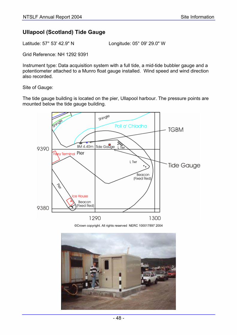
Ullapool (Scotland) Tide Gauge Latitude: 57° 53' 42.9" N Longitude: 05° 09' 29.0" W Grid Reference: NH 1292 9391 Instrument type: Data acquisition system with a full tide, a mid-tide bubbler gauge and a potentiometer attached to a Munro float gauge installed. Wind speed and wind direction also recorded. Site of Gauge: The tide gauge building is located on the pier, Ullapool harbour. The pressure points are mounted below the tide gauge building.
©Crown copyright. All rights reserved NERC 100017897 2004

NTSLF Annual Report 2004 Site Information
- 49 -
Weymouth (Dorset) Tide Gauge Latitude: 50° 36' 30.6" N Longitude: 02° 26' 52.6" W Grid Reference: SY 6840 7885 Instrument type: Data acquisition system with two full tide bubbler gauges installed. Site of Gauge: The tide gauge building is located on Commercial Pier adjacent to the ferry terminal, and the pressure points are located on the pier wall directly in front of the tide gauge building.
©Crown copyright. All rights reserved NERC 100017897 2004

NTSLF Annual Report 2004 Site Information
- 50 -
Whitby (Yorkshire) Tide Gauge Latitude: 54° 29' 24.0" N Longitude: 00° 36' 52.9" W Grid Reference: NZ 8986 1140 Instrument type: Data acquisition system with two full tide and a mid-tide bubbler gauge installed. Site of Gauge: The tide gauge is located in the Harbour Master's Office, Pier Road. The pressure points are positioned underneath the quay adjacent to the Harbour Office.
©Crown copyright. All rights reserved NERC 100017897 2004

NTSLF Annual Report 2004 Site Information
- 51 -
Wick (Scotland) Tide Gauge Latitude: 58° 26' 27.5" N Longitude: 03° 05' 11.0" W Grid Reference: ND 3667 5081 Instrument type: Data acquisition system with two full tide bubbler gauges installed. Site of Gauge: The tide gauge building is sited in the north west corner of Wick harbour next to the ship repair slipway. The pressure points are attached to an unused stilling well beneath the building.
©Crown copyright. All rights reserved NERC 100017897 2004

NTSLF Annual Report 2004 Site Information
- 52 -
Workington (Cumbria) Tide Gauge Latitude: 54° 39' 02.6" N Longitude: 03° 34' 01.8"W Grid Reference: NX 9898 2953 Instrument type: Data acquisition system with two full tide bubbler gauges installed. Site of Gauge: The tide gauge is located in a concrete building on the north side of the dock entrance. The pressure points are located behind fender piles on the north seaward side of the dock gates. The wind speed and direction instruments are mounted at the top of the mast located next to the tide gauge building.
©Crown copyright. All rights reserved NERC 100017897 2003