title 17. subdivisions chapter 17.08. definitions and
TRANSCRIPT

Title 17 (03/2001)
Title 17. SUBDIVISIONS Chapter 17.04. GENERAL PROVISIONS Chapter 17.08. DEFINITIONS AND INTERPRETATION OF LANGUAGE Chapter 17.12. ADMINISTRATION AND ENFORCEMENT Chapter 17.16. APPROVAL OF SUBDIVISION TENTATIVE PLANS AND MASTER
DEVELOPMENT PLANS Chapter 17.20. ZERO LOT SUBDIVISION Chapter 17.22. APPROVAL OF TENTATIVE PLANS FOR PARTITIONS Chapter 17.24. FINAL PLAT Chapter 17.32. CONDOMINIUM CONVERSION Chapter 17.36. DESIGN STANDARDS Chapter 17.40. IMPROVEMENTS Chapter 17.44. PARK DEVELOPMENT Chapter 17.48. DESIGN AND CONSTRUCTION SPECIFICATIONS Chapter 17.52. ROAD DEDICATIONS Chapter 17.56. VARIANCES Table A MINIMUM DESIGN STANDARDS Table B MINIMUM BIKEWAY DESIGN STANDARDS Appendix B SECTION 17.48.420, 17.48.470 SIGN STANDARDS Drawings STANDARD DRAWINGS – JANUARY 2000 Drawing 1-1 UTILITIES – TRENCH IN EXISTING PAVEMENT Drawing 1-2 UTILITIES – TRENCH DEPTH AND VICINITY MAP Drawing 1-3 UTILITIES – STANDARD UTILITY TRENCH DETAIL – ALL WEATHER
SURFACE ROAD Drawing 2-1 STREETS – ALL WEATHER SURFACE ROAD – PARTITION STANDARD Drawing 2-2 STREETS – CONCRETE CURB Drawing 2-3 STREETS – CONCRETE DRIVEWAY APRONS AND CURB CUTS,
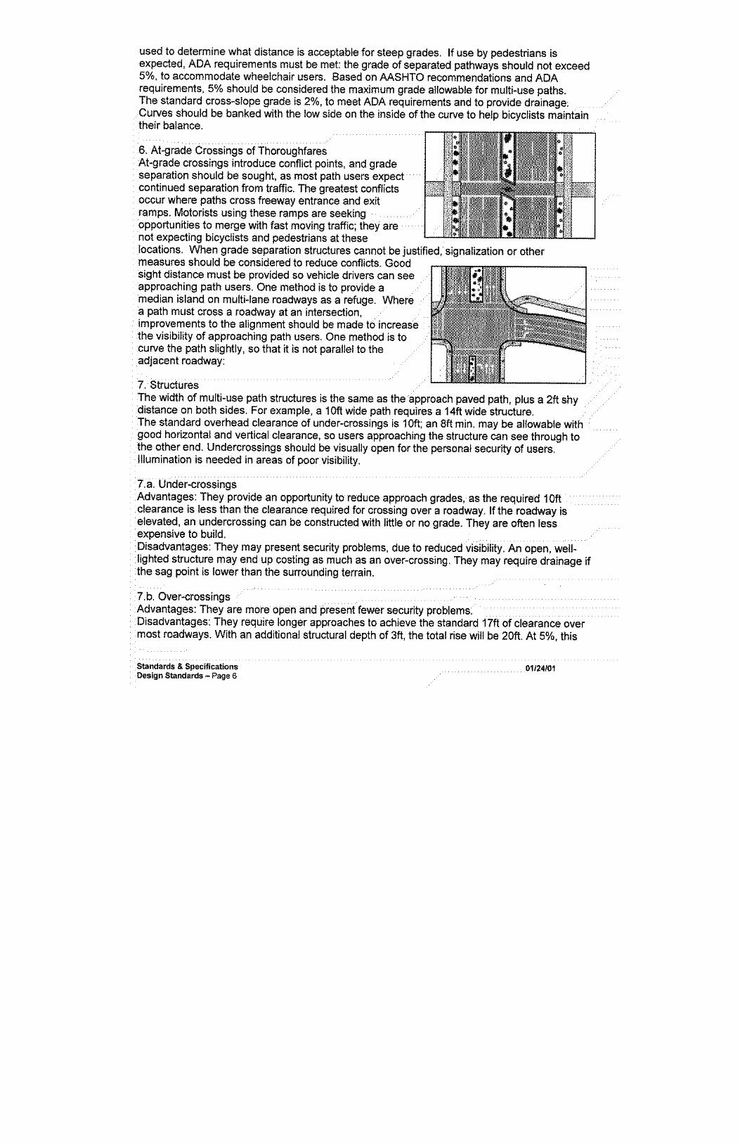
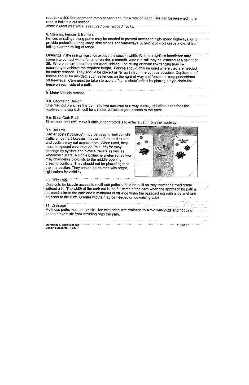
OPTION “A” Drawing 2-4 STREETS – CONCRETE DRIVEWAY APRONS AND CURB CUTS,
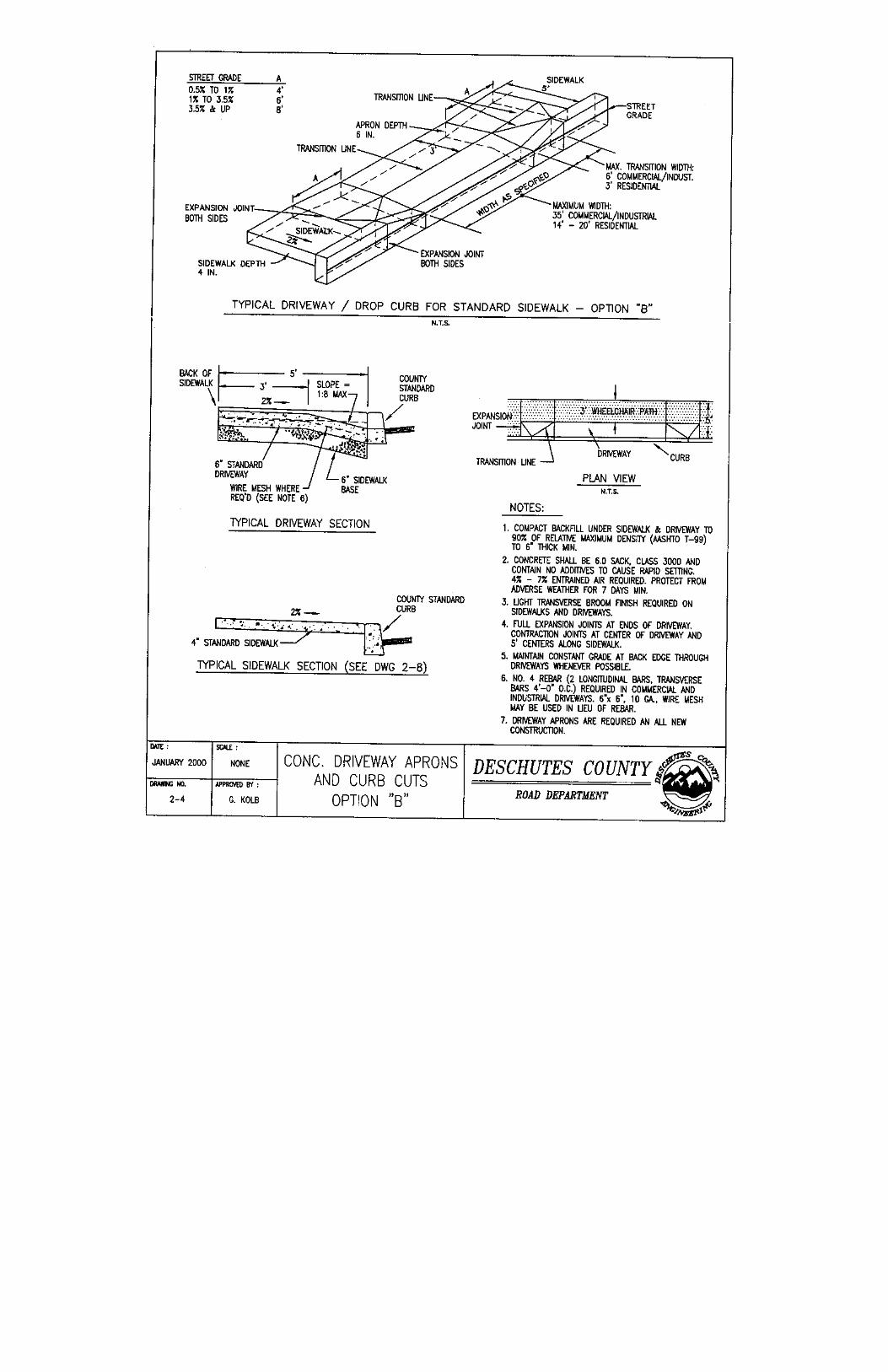
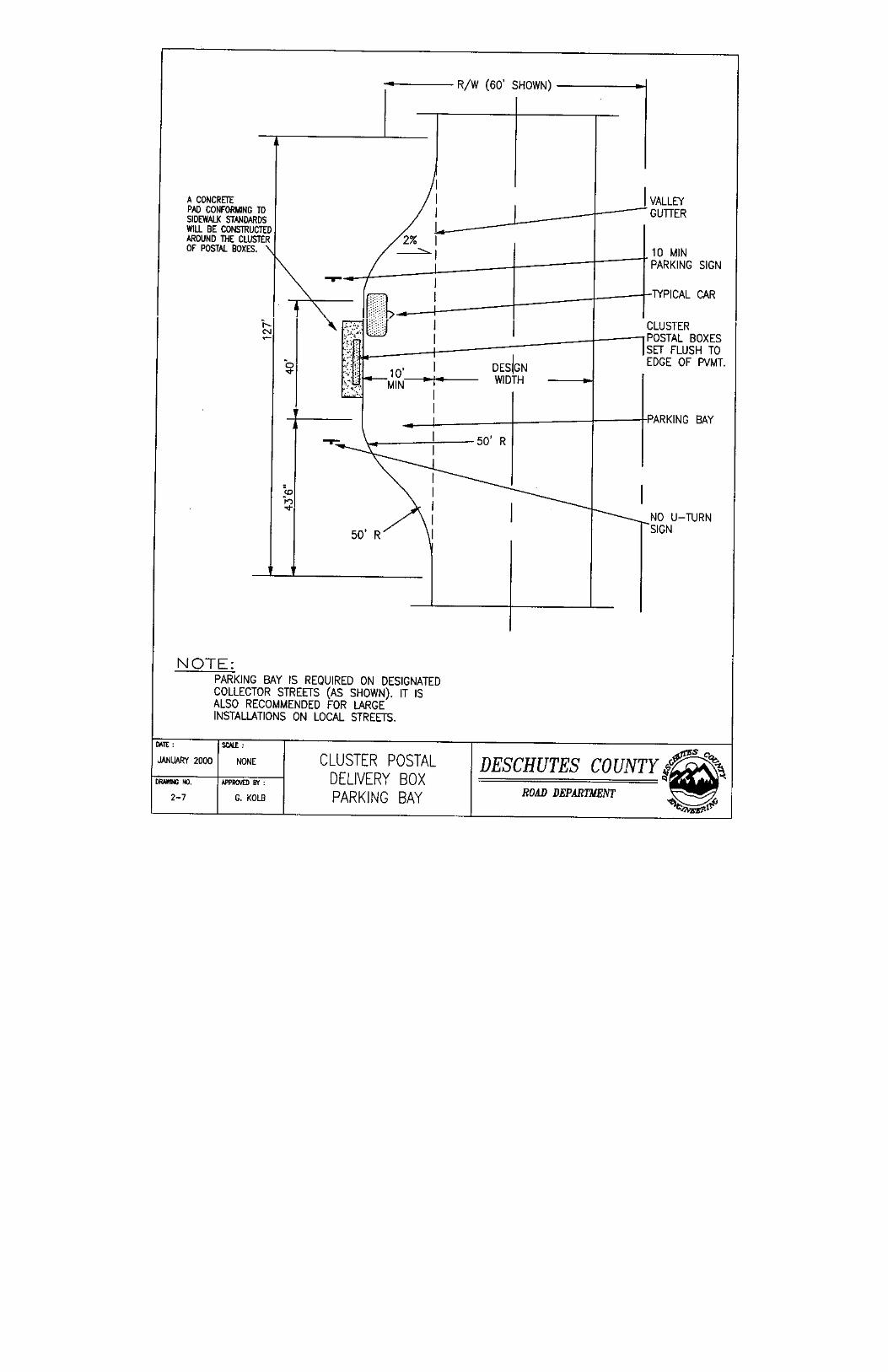
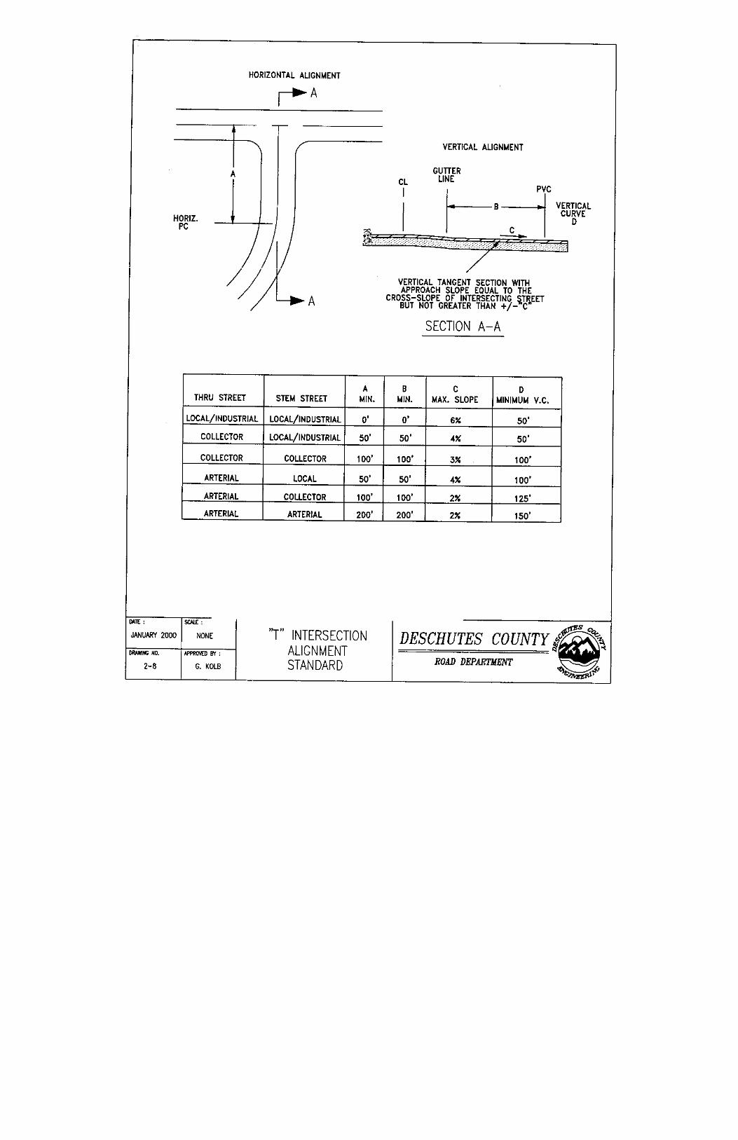
OPTION “B” Drawing 2-5 STREETS – SIDEWALK & CURB RAMPS Drawing 2-6 STREETS – TYPICAL CONCRETE CURB & SIDEWALK DETAIL Drawing 2-7 STREETS – CLUSTER POSTAL DELIVERY BOX PARKING BAY Drawing 2-8 STREETS – “T” INTERSECTION ALIGNMENT STANDARD Drawing 2-9 STREETS – ASPHALT PENETRATION MACADAM (OIL MAT)
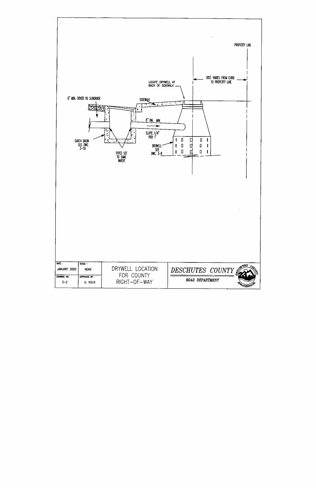
SPECIFICATIONS Drawing 3-1 DRAINAGE – STANDARD PRE-CAST DRYWELL Drawing 3-2 DRAINAGE – DRYWELL LOCATION FOR COUNTY RIGHT-OF-WAY Drawing 3-3 DRAINAGE – STANDARD CATCH BASIN, DOUBLE & SINGLE Drawing 3-4 DRAINAGE – SIDEWALK CATCH BASIN Drawing 3-5 DRAINAGE –STANDARD CATCH BASIN GRATE

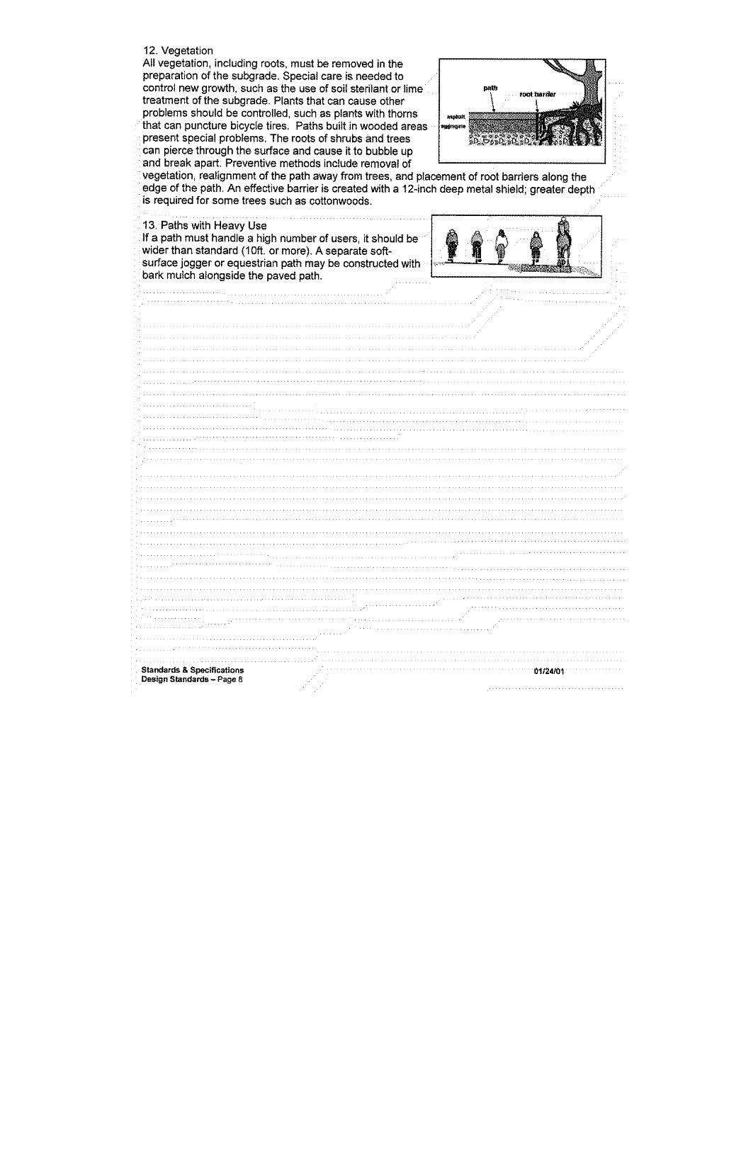
Chapter 17.04. GENERAL PROVISIONS 17.04.010. Short Title. 17.04.020. Purpose. 17.04.030. Interpretation. 17.04.040. Amendments. 17.04.050. Corrections. 17.04.010. Short Title.
DCC Title 17 shall be known as the County Subdivision and Partition Ordinance, and may be so cited and plead. (Ord. 90-003 §1, 1990; Ord. 81-043 §§1 and 1.005, 1981) 17.04.020. Purpose.
A. In accordance with the provisions of ORS 92, 197 and 215, DCC Title 17 sets forth the minimum standards governing the approval of land development, including subdivisions and partitionings, as necessary to carry out the County comprehensive plan and to promote the public health, safety and general welfare. The purpose of these provisions and regulations are to: 1. Encourage well planned subdivision and partition development to the end that good liveable
neighborhoods with all needed amenities and community facilities may be created. 2. Encourage development in harmony with the natural environment and within resource carrying
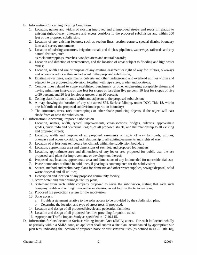
capacities. 3. Safeguard the interest of the public, the applicant and the future lot owner. 4. Improve land records and boundary monumentation. 5. Insure equitable processing of subdivision plats and partitioning plans, and accomplish to the
greatest extent possible the goals and objectives of the comprehensive plan for the County. 6. To regulate the orientation of streets, lots and parcels; the placement, height and bulk of buildings;
and the placement and growth of vegetation within the County to insure access to solar energy by reasonably regulating interests in property within the County, as authorized under ORS 215.044, 105.880 through 105.890 and 92.044 to promote and maximize the conservation of energy by preserving the option to utilize solar energy and to implement the comprehensive plan policies relating to solar energy.
7. To encourage the design of new buildings, structures and developments which use solar energy and protect future options to use solar energy by protecting solar access.
B. No person may subdivide or partition land within the County except in accordance with ORS 92 and the provisions of DCC Title 17.
C. The provisions of DCC Title 17 shall apply only to subdivisions and partitions within the County, unless otherwise noted. All references to "subdivisions" and "partitions" are made in that context unless otherwise noted.
D. DCC Title 17 shall not apply to the lands lying outside the city limits of the city of Bend and within the Bend Urban Growth Boundary, as that term is defined in that certain intergovernmental agreement entered into between the city of Bend and the County dated February 18, 1998. The city of Bend Subdivision Ordinance, No. NS-1349, as adopted by the Board of County Commissioners as DCC Title 17A, and as supplemented by such other supplementing and/or amending ordinances as might from time to time be adopted shall apply to those lands instead.
(Ord. 98-041 §1, 1998; Ord. 95-065 §1, 1995; Ord. 90-003 §1, 1990, Exhibit A; Ord. 83-039 §1, 1983; Ord. 81-043 §1, Exhibit A, §1.010, 1981)
Chapter 17.04 1 (10/2001)

Chapter 17.04 2 (10/2001)
17.04.030. Interpretation.
The provisions of DCC Title 17 shall be construed to effect the purposes set forth in DCC 17.04.020. These provisions are declared to be the minimum requirements fulfilling such objectives, and the County may impose additional requirements deemed necessary to promote the health, safety and general welfare, and to carry out the comprehensive plan of the County. Where conditions set forth in DCC 17.04 are less restrictive than comparative conditions imposed by any other provision of DCC Title 17, by provision of any other local ordinance, resolution or regulation, or by provision of state statute or administrative regulation, the more restrictive shall govern. (Ord. 95-065 §1, 1995; Ord. 81-043 §1, Exhibit A, §1.020, 1981) 17.04.040. Amendments.
DCC Title 17 may be amended or repealed as provided by law. (Ord. 81-043 §1, Exhibit A, §1.020, 1981) 17.04.050. Corrections.
DCC Title 17 may be corrected by order of the Board to cure editorial and clerical errors. (Ord. 90-003 § 1, Exhibit A, 1990; Ord. 81-043 § 1, Exhibit A, §12.080, 1981)

Chapter 17.08. DEFINITIONS AND INTERPRETATION OF LANGUAGE 17.08.010. Construction. 17.08.020. Definitions. 17.08.030. Definitions Generally. 17.08.010. Construction.
In DCC Title 17 the words used in the present tense include the future tense, words used in the singular include the plural and words used in the plural include the singular. The word "shall" is mandatory, the word "may" is permissive. The masculine includes the feminine and neuter. (Ord. 81-043 §1, Exhibit A, §1.030(1), 1981) 17.08.020. Definitions.
The word "County" means the County of Deschutes, State of Oregon. The words "Board of County Commissioners" and "Board" mean the Board of County Commissioners of Deschutes County. The words "Planning Commission" and "Commission" mean the County Planning Commission of the County of Deschutes, duly appointed by the Board of County Commissioners. The words "Planning Director," "Road Department Director," "Assessor," "County sanitarian," "Hearings Officer," "County Surveyor," "County Clerk" and "Tax Collector," mean the Planning Director, Road Department Director, Assessor, Sanitarian, Hearings Officer, Surveyor, County Clerk and Tax Collector of the County. (Ord. 93-012 §1, 1993; Ord. 81-043 §1, Exhibit A, §1.030(2), 1981) 17.08.030. Definitions Generally.
As used in DCC Title 17, the words and phrases set out in DCC 17.08.030 have the following meanings.
“AASHTO Standards” refers to the road safety and design standards set forth in the publication entitled American Association of State Highway and Transportation Officials Policy on Geometric Designs of Highways and Streets, current edition.
"Access" means the right to cross between public and private property allowing pedestrians and vehicles to enter and leave property.
"Access corridor" means a separate travel way for pedestrians and bicyclists to minimize travel distances within and between subdivisions, planned unit developments, residential areas and commercial centers, major employment areas, transit stops, or within and between nearby neighborhood activity centers such as schools, parks and convenience shopping.
"Advertising" means the publication or causing to be published of any material relating to disposition of interest in a land development, which has been prepared for public distribution by any means of communication.
"Affected governmental body" means a city, County, state or federal agency or special district which either has a jurisdictional interest or is of such proximity to the subdivision or land partition that a reasonable likelihood of annexation exists.
"Affected person" means any person adversely affected or aggrieved by a decision relating to the partitioning or subdividing of land.
Chapter 17.08 (2006)
1

"Agent" means any person who represents or acts for any other person in disposing of interests in a land development. "Agent" includes a real estate broker, as defined in ORS 696.025(1), but does not include an attorney at law whose representation of another person consists solely of rendering legal services.
Definition (Repealed by Ord. 90-003, 1990)
"Bicycle" means a vehicle designed to operate on the ground on wheels, propelled solely by human power, upon which any person or persons may ride, and with every wheel more than 14 inches in diameter or two tandem wheels either of which is more than 14 inches in diameter or having three wheels in contact with the ground, any of which is more than 14 inches in diameter.
"Bicycle facilities" means a general term denoting improvements and provisions made to accommodate or encourage bicycling, including parking facilities, all bikeways, and shared roadways not specifically designated for bicycle use.
"Bike route" means a segment of a bikeway system designated with appropriate directional and information markers by the jurisdiction having authority.
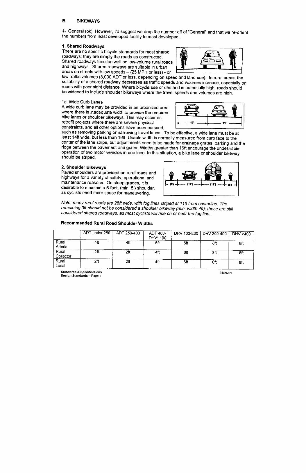
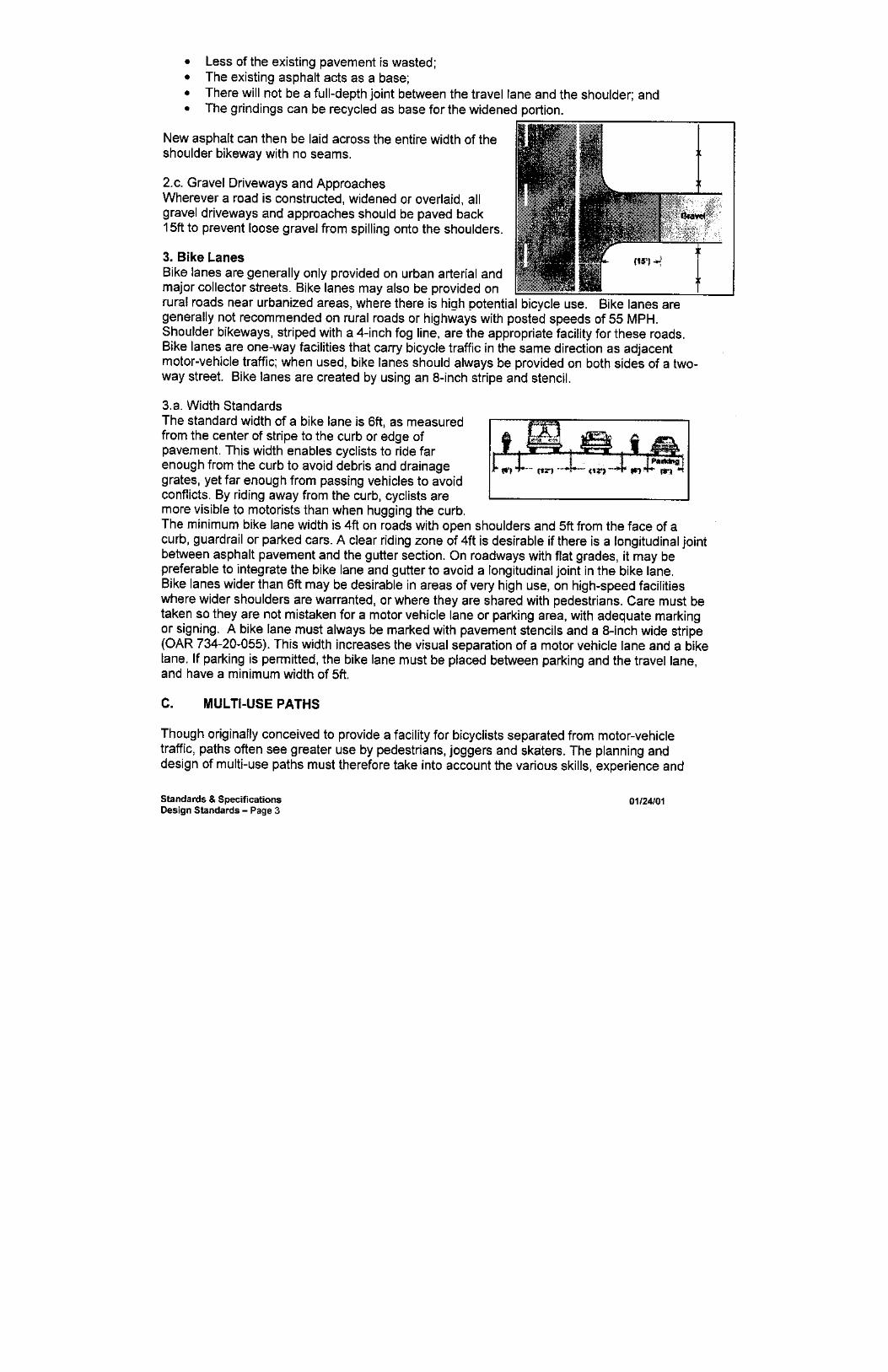
“Bikeway” means Any road, path or way which in some manner is specifically designated as being open to bicycle travel, regardless of whether such facilities are designated for the exclusive use of bicycles or are shared with other transportation modes. The five types of bikeway are: bike path, bike lane, shoulder bikeway, shared roadway and mountain bike trail. A. Bike Path. A bikeway physically separated from motorized vehicular traffic by an open space or barrier
and either within the highway or road right of way or within an independent right of way. B. Bike Lane. A portion of a roadway which has been designated by striping, signing and permanent
markings for the preferential or exclusive use of bicyclists. C. Shoulder Bikeway. A bicycle facility where the bicycle travels on the paved shoulder of the roadway. D. Shared Roadway. A bicycle facility where the bicycle shares the normal vehicle lanes with motorists. E. Bike Trail (Mountain Bike). A bicycle facility designed to accommodate bicycle travel on unpaved
roads and trails.
"Block" means an area of land bounded by streets or by a combination of streets and public parks, cemeteries, railroad rights of way, lines or shore lines or waterways, or corporate boundary lines of a city.
"Building" means a structure which is designated and suitable for the habitation or shelter of human beings or animals, or the shelter or storage of property or for the use and occupation for some purpose of trade or manufacture.
"Building line" means a line on a plat indicating the limit beyond which buildings or structures may not be erected. If no line is shown on the plat, the building line shall be that set forth in the applicable zoning ordinance.
"Comprehensive plan" means a plan as adopted by the County pursuant to ORS 197 and 215, and in compliance with Statewide Planning Goals. A coordinated land use map and policy statement of the County that interrelates all functional and natural systems and activities relating to the use of lands, including, but not limited to, sewer and water systems, transportation systems, educational systems, recreational facilities and natural resources and air and water quality management programs. "Comprehensive" means all-inclusive, both in terms of the geographic area covered by the plan and functional and natural activities and systems occurring in the area covered by the plan. The plan is an expression of public policy in the form of goals, objectives and policy statements, maps, standards and guidelines, and is the basis for DCC Title 17 and other rules, regulations and ordinances which are intended to implement the policies expressed through the plan.
Chapter 17.08 (2006)
2

"Condominium" means a type of residential development utilizing zero lot lines, individual ownerships of units and common ownership of open space and other facilities, and which are regulated in part by state law (ORS 91.010 through 91.652).
"Construction plans" means the plans, profiles, cross-sections and drawings or reproductions thereof, approved by a registered professional engineer, which show the details of the work to be done on improvements.
"Contiguous" means that which touches or connects, including that which only connects or touches a common point; the touching together of two or more tracts of land which lie alongside one another or which touch or connect with one another for any length or distance whatsoever, no matter how finite.
"Contiguous land" means units of land under the same ownership which abut, irrespective of roadways, easements or rights of way.
"Cross-section" means a profile of the ground surface perpendicular to the centerline of a street, stream or valley bottom.
"Cul-de-sac" means a short street having one end open to traffic and terminated by a vehicle turnaround.
"Curblines" means the line dividing the roadway from the planting strip of footway, meaning the inside (street side) of the curb.
"Developer" means any person, corporation, partnership or other legal entity who creates or proposes to create a land development and includes any agent of a developer.
"Disposition" means and includes sale, lease for more than one year, option assignment, award by lottery or as a prize, or any offer or solicitation of any offer to do any of the foregoing concerning a land development or any part of a land development.
"Drainage easement" means an easement required for drainage ditches, or required along a natural stream or watercourse to preserve the channel, to provide for the flow of water therein, and to safeguard the public against flood damage or the accumulation of surface water.
“Drainage swale” is a depression constructed parallel to the right of way between the roadway and the sidewalk for containing storm runoff from streets.
"Easement" means a grant of the right to use a parcel of land for specific purposes, but in which ownership of the land is not transferred.
"Firebreak" means a break in the ground cover fuels as specified by the fire protection agency involved.
"Flood" means the overflow of water onto lands not normally covered by water.
"Flood hazard area" means the relatively flat area of lowlands adjoining the channel of a river, stream, watercourse, land or reservoir.
"Forest purposes" means the current employment of land primarily for the purpose of raising or harvesting timber products.
"Frontage" means that portion of a parcel of property which abuts a dedicated public street or highway or an approved private way (except an alley).
"Initial hearing" means a quasi-judicial hearing authorized and conducted by the Hearings Body to determine if a change or land subdivision or partition shall be granted or denied, except those subject to administrative review.
"Hearings Body" means the Planning Director, Hearings Officer or governing body.
Chapter 17.08 (2006)
3

"Hearings Officer" means a planning and zoning Hearings Officer appointed or designated by the Board of County Commissioners pursuant to ORS 227.165, or, in the absence of such appointed Hearings Officer, the Planning Commission.
"Improvements" mean and include, but are not limited to, streets, alleys, curbs, gutters, roadbed, road surface, storm drains and appurtenances, sidewalks, street lights, street signs, fire hydrants, sanitary sewers and appurtenances, public water supply and water distribution systems and other utilities.
"Interests" means and includes a lot or parcel, share, undivided interest or membership which includes the right to occupy land overnight, and a lessee's interest in land for more than three years or less than three years if the interest may be renewed under the terms of the lease for a total period more than three years. "Interest" does not include any interest in a condominium or any security interest under a land sales contract, trust deed or mortgage. "Interest" does not include divisions of land created by lien foreclosure or foreclosure of recorded contracts for the sale of real property.
"Land development" means the subdividing or partitioning of land for any purpose into parcels or the creation of units or parcels for the purpose of sale or lease for a term of one year or more. "Land development" includes intent to dispose of any land, whether contiguous or not, including any land divided, lots, parcels, unit or interests offered as a part of a common promotional plan of advertising by a single developer or a group of developers acting in concert. If the land is contiguous or is known, designated or advertised as a common unit or by a common name, the land shall be presumed, without regard to the number of lots covered by each individual offering, to be offered for disposition as part of a common promotional plan.
"Lot" means a unit of land that is created by a subdivision of land.
"Lot area" means the total horizontal area contained within the lot lines, such area shall be computed as gross area for lots larger than 2.5 acres and net area for lots 2.5 acres or smaller. The total horizontal net area within lot lines of a lot is that square footage of a lot that is free from roads, streets, rights of way or easements of access to other property; provided, however, that the Planning Director shall include in gross lot areas all streets, roads and easements of access to other property that would accrue to that lot if the road, street or easement were vacated, and shall treat the gross area of lots that have never been previously described of records as other than fractions of a section as if the section contained six hundred forty acres, in cases where a lot is sought to be partitioned.
"Lot, corner" means a lot abutting upon two or more streets other than alleys at their intersection, or upon two parts of the same street, such streets or parts of the same street forming an interior angle of less than 135 degrees within the lot line.
"Lot depth" means the average horizontal distance between the front and rear lot lines.
"Lot line" means any line bounding a "lot" or "parcel" as defined in DCC Title 17.
Definition. (Repealed by Ord. 93-012,1993)
Definition. (Repealed by Ord. 93-012,1993)
Definition. (Repealed by Ord. 93-012,1993)
"Lot, through" means an interior lot having a frontage on two streets and/or highways, not including an alley.
"Lot width" means the horizontal distance between the side lot lines measured within the lot boundaries or the average distance between side lot lines within the buildable area. In the case of a corner lot, lot width shall mean the mean horizontal distance between the longest front lot line and the opposite lot line not abutting the street.
Chapter 17.08 (2006)
4

Definition. (Repealed by Ord. 90-003,1990)
"Monument" means a permanent and fixed survey marker conforming to the requirements established by state law and the regulations of the County.
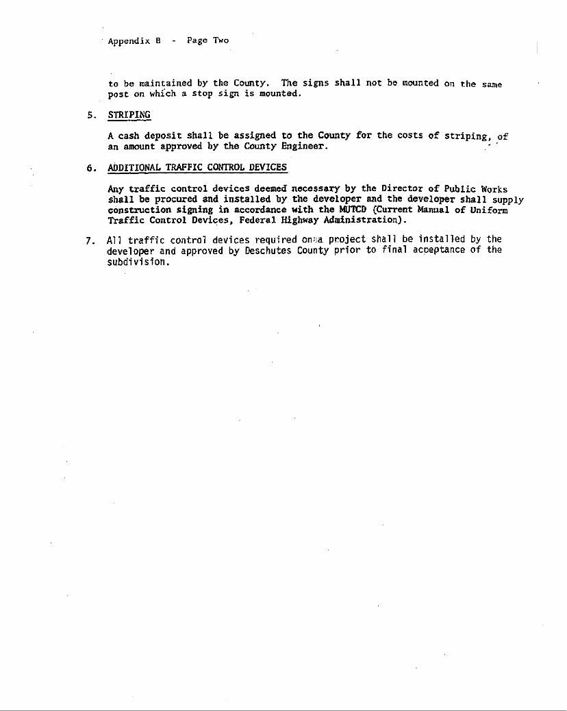
"MUTCD" means the Manual of Uniform Traffic Control Devices, Federal Highway Administration.
"Negotiate" means any activity preliminary to the execution of a binding agreement for the sale of land in a subdivision or partition, including, but not limited to, advertising, solicitation and promotion of the sale of such land.
"Offer" means and includes every inducement, solicitation or encouragement of a person to acquire a lot, unit, parcel or interest in land.
"Owner" means the owner of the title to real property or the authorized agent thereof having written notarized authorization recorded with the County Clerk, or the contract purchaser of real property of record as shown on the last available complete tax assessment roll or County Clerk's records. "Owner" does not include an interest created for security purposes.
"Parcel" means a unit of land created by a partitioning of land.
"Partition" means the act of partitioning land or an area or tract of land partitioned.
"Partition land" means to divide land into two or three parcels of land within a calendar year but does not include: A. A division of land resulting from a lien foreclosure, foreclosure of a recorded contract for the sale of real
property or the creation of cemetery lots; B. An adjustment of a property line by the relocation of a common boundary where an additional unit of
land is not created and where the existing unit of land reduced in size by the adjustment complies with any applicable zoning ordinance; or
C. A sale or grant by a person to a public agency or public body for state highway, County road, city street or other right of way purposes provided that such road or right of way complies with the applicable comprehensive plan and ORS 215.213 (2)(q) to (s) and 215.283 (2)(p) to (r). However, any property divided by the sale or grant of property for state highway, County road, city street or other right of way purposes shall continue to be considered a single unit of land until such time as the property is further subdivided or partitioned.
"Person" means an individual, firm, partnership, corporation, company, association, syndicate or any legal entity, whether he, she or it is acting for himself, herself or itself, or as the servant, employee, agent or representative of another.
"Planned unit development" means a complex of residential, commercial and/or industrial structures designed and developed as a single development unit, built by a single owner or group of owners and maintained by an association. The phrase "planned unit development" may be abbreviated PUD.
"Plat" means a final map, diagram, drawing, replat or other writing containing all descriptions, specifications, locations, dedications, provisions and information concerning a subdivision or partition.
"Potable water" means water which is sufficiently free from biological, chemical or radiological impurities so that users thereof will not be exposed to or threatened with exposure to disease or harmful physiological effects, and which has such other physical properties as to be reasonably palatable to humans for drinking purposes. Irrigation water shall not be considered potable water for purposes of DCC Title 17.
"Property line" means the division line between two units of land.
"Property line adjustment" means the relocation of a common property line between two abutting properties.
Chapter 17.08 (2006)
5

"Public water system" means a system for the provision to the public of piped water for human consumption, if such system has more than three service connections or supplies water to a public or commercial establishment which operates a total of at least 60 days per year, and which is used by 10 or more individuals per day or is a facility licensed by the State Health Division. A public water system is either a "community water system," a "noncommunity water system" or a "nontransient, noncommunity water system." A. "Community water system" means a public water system which has 15 or more service connections used
by year-round residents, or which regularly serves 25 or more year-round residents; B. "Noncommunity water system" means a public water system that is not a community water system; C. "Nontransient, noncommunity water system" or "NTNCWS" means a public water system that is not a
community water system and that regularly serves at least 25 of the same persons over six months per year.
"Replat" means the act of platting the lots, parcels and easements in a recorded subdivision or partition plat to achieve a reconfiguration of the existing subdivision or partition plat or to increase or decrease the number of lots in the subdivision.
"Reserve strip" means a strip of land usually one foot in width, reserved across the end of a street or alley terminating at the boundary of a subdivision, or a strip of land between a dedicated street of less than full width and adjacent acreage, in either case reserved or held for future street extension or widening.
"Right of way" means the area within the boundary line of a public roadway, including an alley.
"Road" or "street" means a public or private way that is created to provide ingress and egress to one or more lots, parcels, areas or tracts of land, excluding a private way that is created to provide ingress and egress to land in conjunction with the use of such land for forestry, mining or agricultural purposes. A. "Alley" means a public way through the middle of a block, giving access to the rear of parcels or
buildings. B. "Arterial" includes three types of arterials, Principal Arterial, Urban Minor and Rural Minor Arterial,
defined as follows: 1. "Principal Arterial" means a road which carries the major portion of trips entering and leaving the
urban areas and outlying rural and recreation areas (state highways). 2. "Urban Minor Arterial" means a road that interconnects with and augments the principal arterial
system and provides service to intra-urban/intra-community areas. 3. "Rural Minor Arterial" means a road that connects with the principal arterial system and forms the
rural road network that links cities and unincorporated communities (as that term is defined in DCC Title 18).
C. "Collector" means a restricted access street supplementary to the arterial street system used or intended to be used primarily for the movement of traffic between arterials and local streets.
D. "Frontage road" means a street parallel and adjacent to an arterial providing access to abutting properties, but protected from through traffic.
E. "Industrial road" means a street to or through property zoned industrial. F. "Local street" means a street which provides access to property abutting the public right of way; this
includes vehicular and pedestrian access. Moving traffic is a secondary function of a local street and it should not carry through traffic.
G. "Modernization" means the widening or reconstruction of an existing County road to an adopted County standard.
H. "Special pedestrian way" means a sidewalk or pathway not located within a public road right of way which enables pedestrian access to a street, school, park or other similar facility or service.
I. "Stubbed street" means a street having only one outlet for vehicular traffic and which is intended to be extended or continued to serve future subdivisions or developments on adjacent lands.
Chapter 17.08 (2006)
6

"Road and street project" means the construction and maintenance of the roadway, bicycle lanes, sidewalks or other facilities related to a road or street. Road and street projects shall be a Class I, Class II or Class III project. A. Class I Project. Land use permit required. "Class I Project" is a major project such as:
1. A new controlled-access freeway; 2. A road or street project of four or more lanes on a new location; and 3. A major project involving the acquisition of more than minor amounts of rights of way, substantial
changes in access control, a large amount of demolition, displacement of a large amount of residences or businesses, or substantial change in local traffic patterns.
B. Class II Project. Land use permit required. "Class II Project" is a 1. Modernization where a road or street is widened by more than one lane; 2. Traffic safety or intersection improvement which changes local traffic patterns; 3. System change which has significant land use implications; or, 4. The construction of a new County road or street within a dedicated public right-of-way, where none
existed before. (Ord. 2006-007 §1, 2006; Ord. 97-005 §1, 1997; Ord. 96-003 §10, 1996; Ord. 95-065 §1, 1995; Ord. 93-012 §§2-7, 1993; Ord. 90-003 §1, Exhibit A, 1990; Ord. 88-015 §1, 1988; Ord. 86-015 §2, 1986; Ord. 83-039 §2, 1983; Ord. 81-043 §1, Exhibit A, §1.040, 1981) C. Class III Project. No land use permit required. "Class III Project" is a modernization, traffic safety
improvement, maintenance, repair or preservation of a road or street.
"Roadway" means that portion of a street developed for vehicular traffic.
"Sale" or "lease" means every disposition or transfer of land in a subdivision or partition or an interest or estate therein by a subdivider or developer or their agents. "Sale" or "lease" includes the offering of land as a prize or gift when a monetary charge or consideration for whatever purpose is required by the subdivider, developer or their agents.
"Series partitioned lands" and "series partition" mean a series of partitions of land resulting in the creation of four or more parcels over a period of more than one calendar year.
"Sidewalk" means a pedestrian walkway with permanent surfacing.
"Solar access" means protection from shade for a specific area during specific hours and dates.
"Solar height restriction" means the allowable height of buildings, structures and vegetation on a property burdened by the solar access of another property.
"Subdivide land" means to divide an area or tract of land into four or more lots within a calendar year.
"Subdivider" means any person who causes land to be divided into a subdivision or partition for himself or for others or who undertakes to develop a subdivision or partition, but does not include a public agency or officer authorized by law to make subdivisions or partitions.
"Subdivision" means the act of subdividing land or an area or a tract of land subdivided, as defined in DCC 17.08.030.
"Tentative plan" means a map setting forth the proposed plan of a subdivision or partition in conformance with the provisions of DCC Title 17 and subject to review and modification.
"Use" means the purpose for which land or a structure is designated, arranged or intended, or for which it is occupied or maintained.
"Utilities" means and includes electric, telephone, natural gas and other services providing for energy or communication needs.
Chapter 17.08 (2006)
7

Chapter 17.08 (2006)
8
Definition. (Repealed by Ord. 93-012, 1993)
"Within the County" refers to subdivisions or partitions subject to Deschutes County land use regulatory authority.
"Zero lot line" means the location of a building or a lot or parcel in such a manner that one or more of the building's sides coincide with a lot line. (Ord. 97-005 §1, 1997; Ord. 96-003 §10, 1996; Ord. 950065 §1, 1995; Ord. 93-012 §§2-7, 1993; Ord. 90-003 §1, Exhibit A, 1990; Ord. 88-015 §1, 1988; Ord. 86-015 §2, 1986; Ord. 83-039 §2, 1983; Ord. 81-043 §1, Exhibit A, §1.040, 1981)

Chapter 17.12 1 (04/2003)
Chapter 17.12. ADMINISTRATION AND ENFORCEMENT 17.12.010. Minimum Standards. 17.12.020. Repealed. 17.12.030. Administration-Enforcement. 17.12.040. Delegation of Authority. 17.12.050. Planning Director-Duties and Responsibilities. 17.12.060. Final Decision. 17.12.070. Pre-application Meeting. 17.12.080. Statement of Water Rights. 17.12.090. Recording-Application. 17.12.100. Sale of Subdivision Lots Prohibited Before Final Approval. 17.12.105. Sale of Partition Parcels Prohibited Prior to Tentative Plan Approval. 17.12.110. Civil Relief. 17.12.120. Violation-Nuisance. 17.12.130. Violation. 17.12.010. Minimum Standards.
All proposed subdivisions and partitions within the County shall be considered for approval by the County under DCC Title 17. In addition, no such proposed subdivision or partition shall be approved unless it complies with the comprehensive plan for the County and/or the applicable urban area comprehensive plan, and the applicable zoning ordinance and ORS 92. (Ord. 93-012 §9, 1993; Ord. 90-003 §1, Exhibit A, 1990; Ord. 81-043 §1, Exhibit A, §2.020, 1981) 17.12.020. (Repealed by Ord. 93-012, 1993) 17.12.030. Administration-Enforcement.
It shall be the duty of the Planning Director or his designated representatives to administer and enforce the provisions of DCC Title 17 in such a way as to carry out its intent and purpose. (Ord. 81-043 §1, Exhibit A, §2.020, 1981) 17.12.040. Delegation of Authority.
Pursuant to ORS 92.044(2)(a) and 92.046(3), the Board delegates to the Planning Director and Hearings Officer the power to take final action on a proposed subdivision or partition, subject to appeal as provided for under DCC Title 17 and the Deschutes County Development Procedures Ordinance. (Ord. 90-003 §1, Exhibit A, 1990; Ord. 81-043 §1, Exhibit A, §2.040, 1981) 17.12.050. Planning Director-Duties and Responsibilities.
A. The Planning Director shall review all applications for subdivisions and partitions and shall, consistent with the Deschutes County Development Procedures Ordinance, either act upon the application before him administratively or refer the application to a Hearings Officer.
B. Before making an administrative decision on a subdivision or partition application, the Planning Director shall solicit comments on the proposal from the Road Department Director, the County environmental health division, and representatives of any other appropriate County, city, state or federal agency.
C. Before referring to the Hearings Officer and completing the staff report on an application for a subdivision or partition, the Planning Director shall solicit comments on the proposal from the Road

Chapter 17.12 2 (04/2003)
Department Director, the County environmental health division, and any other appropriate County, city, state or federal agency.
(Ord. 93-012 §11, 1993; Ord. 90-003 §1, Exhibit A, 1990; Ord. 81-043 §1, Exhibit A, §2.060, 1981) 17.12.060. Final Decision.
The time for taking final action upon an application for approval of a subdivision or partition shall be as provided for in the Deschutes County Development Procedures Ordinance. (Ord. 90-003 §1, Exhibit A, 1990; Ord. 81-043 §1, Exhibit A, §2.050, 1981) 17.12.070. Preapplication Meeting.
Prior to submitting an application for a subdivision or partition, each applicant is encouraged to meet with the Planning Director or a designated staff member to review the proposal. The intent of this meeting is to advise the applicant of the requirements and standards of DCC Title 17 and any applicable zoning standards. (Ord. 90-003 §1, Exhibit A, 1990) 17.12.080. Statement of Water Rights.
All applicants for a subdivision or partition shall be informed by the Planning Director or his designee of the requirement to include a statement of water rights on the final plat. (Ord. 93-012 §12, 1993; Ord. 90-003 §1, Exhibit A, 1990) 17.12.090. Recording-Application.
Before a plat of any subdivision or partition may be made and recorded, the person proposing the subdivision or the partition, or his authorized agent or representative, shall make an application in writing to the County Planning Department for approval of the proposed subdivision or partition in accordance with the requirements and procedures established by DCC Title 17. (Ord. 90-003 §1, Exhibit A, 1990; Ord. 81-043 §1, Exhibit A, §2.010, 1981) 17.12.100. Sale of Subdivision Lots Prohibited Before Final Approval.
No person shall sell any lot in any subdivision until final approval of the land division has been granted by the County. Final approval occurs when the plat of the subdivision or partition is recorded with the County Clerk. No person shall negotiate to sell any lot in a subdivision until a tentative plan has been approved. (Ord. 93-012 §13, 1993; Ord. 90-003 §1, Exhibit A, 1990; Ord. 81-043 §1, Exhibit A, §2.030, 1981) 17.12.105. Sale of Partition Parcels Prohibited Prior to Tentative Plan Approval.
No person may sell any parcel in a partition prior to approval of the tentative plan. Prior to approval of the tentative plan, a person may negotiate to sell any parcel of a proposed partition. (Ord. 93-012 §14, 1993) 17.12.110. Civil Relief.
When any real property is or is proposed to be used, transferred, sold or disposed of in violation of DCC Title 17, the Planning Director or any person whose interest in the property is or may be affected by the violation, in addition to other remedies provided by law, may institute injunction, mandamus, abatement or other appropriate proceedings to prevent, temporarily or permanently enjoin, abate or set aside such use, transfer, sale, disposition, offer, negotiation or agreement. (Ord. 90-003 §1, Exhibit A, 1990; Ord. 81-043 §1, Exhibit A, §2.040, 1981)

Chapter 17.12 3 (04/2003)
17.12.120. Violation-Nuisance.
A land division or use in violation of DCC Title 17 is declared a nuisance. (Ord. 90-003 §1 Exhibit A, 1990; Ord. 81-043 §1, Exhibit A, §2.020, 1981) 17.12.130. Violation.
Violation of any provision of DCC Title 17 is a Class A violation. (Ord. 2003-021 §36, 2003; Ord. 90-003 §1, Exhibit A, 1990; Ord. 83-027 §1, 1983; Ord. 81-043 §1, Exhibit A, §2.040, 1981)

Chapter 17.16. APPROVAL OF SUBDIVISION TENTATIVE PLANS AND MASTER DEVELOPMENT PLANS
17.16.010. Application-Submission. 17.16.020. Scale of Tentative Plan. 17.16.030. Informational Requirements. 17.16.040. Protective Covenants and Homeowner Association Agreements. 17.16.050. Master Development Plan. 17.16.060. Master Development Plan-Approval. 17.16.070. Development Following Approval. 17.16.080. Tentative Plan as a Master Plan. 17.16.090. Tentative Plan Approval. 17.16.100. Required Findings for Approval. 17.16.105. Access to Subdivisions. 17.16.110. Resubmission of Denied Tentative Plan. 17.16.115. Traffic Impact Study. 17.16.010. Application-Submission.
Any person proposing a subdivision, or his authorized agent or representative, shall include with an application and filing fee for a subdivision, a tentative plan, together with improvement plans and other supplementary material as may be required. A master development plan may also be required in accordance with DCC 17.16.050. The applicant must submit 20 copies of any plan required, together with all required accompanying material to the Planning Department. (Ord. 90-003 §1, Exhibit A, 1990; Ord. 81-043 §1, Exhibit A, §3.015, 1981) 17.16.020. Scale of Tentative Plan.
The tentative plan of a proposed subdivision shall be drawn on a sheet at a scale not greater than one inch per 400 feet, or as approved by the Planning Department. (Ord. 90-003 §1, Exhibit A, 1990; Ord. 81-043 §1, Exhibit A, §3.020, 1981) 17.16.030. Informational Requirements.
The following information shall be shown on the tentative plan or provided in accompanying materials. No tentative plan shall be considered complete unless all such information is provided. A. General Information Required.
1. Proposed name of the subdivision; 2. Names, addresses and phone numbers of the owners of record, authorized agents or representatives,
engineer or surveyor, and any assumed business names filed or to be filed with the Corporation Commission by the applicant;
3. Date of preparation, true north, scale and gross area of the proposed subdivision; 4. Appropriate identification of the drawing as a tentative plan for a subdivision; 5. Location and tract designation sufficient to define its location and boundaries, and a legal
description of the tract boundaries in relation to existing plats and streets; 6. Certified copy of the recorded instrument under which the applicant claims an ownership interest,
such as a copy of a land sales agreement or similar binding agreement, which binds the applicant in the event of tentative approval;
7. Title report or subdivision guarantee.
Chapter 17.16 (2006) 1
B. Information Concerning Existing Conditions. 1. Location, names and widths of existing improved and unimproved streets and roads in relation to
existing right-of-way, bikeways and access corridors in the proposed subdivision and within 200 feet of the proposed subdivision;
2. Location of any existing features, such as section lines, section corners, special district boundary lines and survey monuments;
3. Location of existing structures, irrigation canals and ditches, pipelines, waterways, railroads and any natural features, such as rock outcroppings, marshes, wooded areas and natural hazards;
4. Location and direction of watercourses, and the location of areas subject to flooding and high water tables;
5. Location, width and use or purpose of any existing easement or right of way for utilities, bikeways and access corridors within and adjacent to the proposed subdivision;
6. Existing sewer lines, water mains, culverts and other underground and overhead utilities within and adjacent to the proposed subdivision, together with pipe sizes, grades and locations;
7. Contour lines related to some established benchmark or other engineering acceptable datum and having minimum intervals of two feet for slopes of less than five percent, 10 feet for slopes of five to 20 percent, and 20 feet for slopes greater than 20 percent;
8. Zoning classification of lands within and adjacent to the proposed subdivision; 9. A map showing the location of any site zoned SM, Surface Mining, under DCC Title 18, within
one-half mile of the proposed subdivision or partition boundary; 10. The structures, trees, rock outcroppings or other shade producing objects, if the object will cast
shade from or onto the subdivision. C. Information Concerning Proposed Subdivision.
1. Location, names, width, typical improvements, cross-sections, bridges, culverts, approximate grades, curve radii and centerline lengths of all proposed streets, and the relationship to all existing and proposed streets;
2. Location, width and purpose of all proposed easements or rights of way for roads, utilities, bikeways and access corridors, and relationship to all existing easements and rights of way;
3. Location of at least one temporary benchmark within the subdivision boundary; 4. Location, approximate area and dimensions of each lot, and proposed lot numbers; 5. Location, approximate area and dimensions of any lot or area proposed for public use, the use
proposed, and plans for improvements or development thereof; 6. Proposed use, location, approximate area and dimensions of any lot intended for nonresidential use; 7. Phase boundaries outlined in bold lines, if phasing is contemplated for the subdivision; 8. Source, method and preliminary plans for domestic and other water supplies, sewage disposal, solid
waste disposal and all utilities; 9. Description and location of any proposed community facility; 10. Storm water and other drainage facility plans; 11. Statement from each utility company proposed to serve the subdivision, stating that each such
company is able and willing to serve the subdivision as set forth in the tentative plan; 12. Proposed fire protection system for the subdivision; 13. Solar access:
a. Provide a statement relative to the solar access to be provided by the subdivision plan. b. Determine the location and type of street trees, if proposed.
14. Location and design of all proposed bicycle and pedestrian facilities; 15. Location and design of all proposed facilities providing for public transit. 16. Appropriate Traffic Impact Study as specified in 17.16.115.
D. Information for lots located in Surface Mining Impact Area (SMIA) zones. For each lot located wholly or partially within a SMIA zone, an applicant shall submit a site plan, accompanied by appropriate site plan fees, indicating the location of proposed noise or dust sensitive uses (as defined in DCC Title 18),
Chapter 17.16 (2006) 2
the location and dimensions of any mitigating berms or vegetation and data addressing the standards of DCC 18.56, as amended, with respect to proposed noise or dust sensitive uses.
(Ord. 2006-007 §2, 2006; Ord. 2006-004 §1, 2006; Ord. 93-012 §15, 1993; Ord. 90-003 §1, Exhibit A, 1990; Ord. 83-039 §§3-5, 1983; Ord. 81-043 §1, Exhibit A, §3.025, 1981) 17.16.040. Protective Covenants and Homeowner Association Agreements.
Landowner covenants, conditions, and restrictions and homeowner association agreements are not relevant to approval of subdivisions and partitions under DCC Title 17, unless otherwise determined by the County to carry out certain conditions of approval, such as road maintenance or open space preservation. Any provisions in such agreements not in conformance with the provisions of DCC Title 17 or applicable zoning ordinances are void. (Ord. 93-012 §16, 1993; Ord. 90-003 §1, Exhibit A, 1990) 17.16.050. Master Development Plan.
An overall master development plan shall be submitted for all developments affecting land under the same ownership for which phased development is contemplated. The master plan shall include, but not be limited to, the following elements: A. Overall development plan, including phase or unit sequence; B. Show compliance with the comprehensive plan and implementing land use ordinances and policies; C. Schedule of improvements, initiation and completion; D. Overall transportation and traffic pattern plan, including bicycle, pedestrian and public transit
transportation facilities and access corridors; E. Program timetable projection; F. Development plans for any common elements or facilities; G. If the proposed subdivision has an unknown impact upon adjacent lands or lands within the general
vicinity, the Planning Director or Hearings Body may require a potential development pattern for streets, bikeways and access corridors for adjoining lands to be submitted together with the tentative plan as part of the master development plan for the subject subdivision.
(Ord. 93-012 §17, 1993; Ord. 81-043 §1, Exhibit A, §3.030, 1981) 17.16.060. Master Development Plan- Approval.
The Planning Director or Hearings Body shall review a master development plan at the same time the tentative plan for the first phase is reviewed. The Planning Director or Hearings Body may approve, modify or disapprove the master plan and shall set forth findings for such decision. The Planning Director or Hearings Body may also attach conditions necessary to bring the plan into compliance with all applicable land use ordinances and policies. Any tentative plan submitted for the plan area shall conform to the master plan unless approved otherwise by the County. Master plan approval shall be granted for a specified time period by the Planning Director or Hearings Body, and shall be included in the conditions of approval. (Ord. 93-012 §18, 1993; Ord. 90-003 §1, Exhibit A, 1990; Ord. 81-043 §1, Exhibit A, §3.030, 1981) 17.16.070. Development Following Approval.
Once a master plan is approved by the County, the plan shall be binding upon both the County and the developer; provided, however, after five years from the date of approval of the plan, the County may initiate a review of the plan for conformance with applicable County regulations. If necessary, the County may require changes in the plan to bring it into conformance. (Ord. 81-043 §1, Exhibit A, §3.040, 1981)
Chapter 17.16 (2006) 3

17.16.080. Tentative Plan as a Master Plan.
A. As an alternative to the filing of a master plan for phased development, the applicant may file a tentative plan for the entire development. The plan must comply with the provisions of DCC Title 17 for tentative plans.
B. If the applicant proposed to phase development, he shall provide sufficient information regarding the overall development plan and phasing sequence when submitting the tentative plan.
C. If the tentative plan is approved with phasing, the final plat for each phase shall be filed in accordance with DCC 17.24.020 through 17.24.110.
(Ord. 81-043 §1, Exhibit A, §3.045, 1981) 17.16.090. Tentative Plan Approval.
A. The Hearings Body shall review the application and any comments submitted by other appropriate County, state, or federal agencies and shall render a decision in accordance with DCC 17.16.100, setting forth findings supporting its decision.
B. Approval of the tentative plan shall not constitute final acceptance of the plat of the proposed subdivision for purposes of recording; however, approval of such tentative plan shall be binding upon the County for the purposes of preparation and review of the final plat. Upon review of the final plat, the County may require compliance with the terms of its tentative plan approval of the proposed subdivision and the terms of DCC Title 17.
(Ord. 90-003 §1, Exhibit A, 1990; Ord. 81-043 §1, Exhibit A, §3.055(1), 1981) 17.16.100. Required Findings for Approval.
A tentative plan for a proposed subdivision shall not be approved unless the Planning Director or Hearings Body finds that the subdivision as proposed or modified will meet the requirements of DCC Title 17 and DCC Title 18 through 21, and is in compliance with the comprehensive plan. Such findings shall include, but not be limited to, the following: A. The subdivision contributes to orderly development and land use patterns in the area, and provides for
the preservation of natural features and resources such as streams, lakes, natural vegetation, special terrain features, agricultural and forest lands and other natural resources.
B. The subdivision will not create excessive demand on public facilities and services, and utilities required to serve the development.
C. The tentative plan for the proposed subdivision meets the requirements of ORS 92.090. D. For subdivision or portions thereof proposed within a Surface Mining Impact Area (SMIA) zone under
DCC Title 18, the subdivision creates lots on which noise or dust sensitive uses can be sited consistent with the requirements of DCC 18.56, as amended, as demonstrated by the site plan and accompanying information required under DCC 17.16.030.
E. The subdivision name has been approved by the County Surveyor. (Ord. 93-012 §19, 1993; Ord. 90-003 §1, Exhibit A, 1990; Ord. 81-043 §1, Exhibit A, §3.060, 1981) 17.16.105. Access to Subdivisions.
No proposed subdivision shall be approved unless it would be accessed by roads constructed to County standards and by roads accepted for maintenance responsibility by a unit of local or state government. This standard is met if the subdivision would have direct access to an improved collector or arterial, or in cases where the subdivision has no direct access to such a collector or arterial, by demonstrating that the road accessing the subdivision from a collector or arterial meets relevant County standards and has been accepted for maintenance purposes. (Ord. 93-012 §19(A), 1993)
Chapter 17.16 (2006) 4

17.16.110. Resubmission of Denied Tentative Plan.
A. If the tentative plan for a subdivision is denied, resubmittal thereof shall not be accepted for a period of six months after the date of the final action denying such plan. Upon resubmission, the applicant shall consider all items upon which the prior denial was based, and the resubmission shall be accompanied by a new filing fee.
B. A tentative plan resubmitted in accordance with DCC 17.16.110 shall be reviewed in the same manner as any other tentative plan.
(Ord. 90-003 §1, Exhibit A, 1990; Ord. 81-043 §1, Exhibit A, §3.035, 1981) 17.16.115. Traffic Impact Studies.
A. For purposes of DCC 17.16.115, the transportation system includes public and private roads, intersections, sidewalks, bike facilities, trails, and transit systems.
B. The applicant shall meet with County staff in a pre-application conference to discuss study requirements, then generate the traffic study and submit it concurrently with the land use application.
C. Guidelines for Traffic Impact Studies 1. All traffic impact studies shall be conducted under the direction of a professional traffic engineer
who is licensed in the State of Oregon and is otherwise qualified to prepare traffic studies. 2. The final report shall be stamped and signed by the Registered Professional Traffic Engineer
responsible for the document. 3. The County Engineer shall determine when the report has satisfied all the requirements of the
development’s impact analysis. Incomplete reports shall be returned for completion. 4. The following vehicle trip generation thresholds shall determine the level and scope of
transportation analysis required for a new or expanded development. a. No Report is required if there are fewer than 50 trips per day generated during a weekday. b. Site Traffic Report (STR): If the development or change in use will cause the site to generate
50-200 daily trip ends, and less than 20 PM peak hour trips, a Site Traffic Report will be required.
c. Traffic Impact Analysis (TIA): If the development or change in use will generate more than 200 trip ends and 20 or more PM peak hour trips, then a Traffic Impact Analysis (TIA) shall be required.
D. Traffic Study Area 1. After consulting with other affected jurisdictions, the County Engineer shall determine the impact
analysis area. 2. The impact analysis study area shall include, at a minimum:
a. All site access points to the public roadway system via either a driveway or private roadway; b. Nearest intersecting collector or arterial roads to the development that would experience an
increase of 25 additional peak hour trips; c. Any other collector or arterial intersection requested by staff.
E. Study Time Frames The analysis shall include the following time frames: 1. Existing conditions (including approved, but not yet built developments as identified by the
County Engineer); 2. Completion year of each significant phase of the development; 3. Five year forecast after build out for each phase of development or the final phase of
development. 4. Generators of large volumes of traffic (>5,000 daily and >500 peak hour trips), zone changes, and
any destination resort development will also require an analysis of traffic conditions in a twenty-year horizon.
F. Minimum Study Requirements for a Site Traffic Report (STR) The minimum study requirements for a Site Traffic Report are:
Chapter 17.16 (2006) 5

Chapter 17.16 (2006) 6
1. A vicinity map showing the location of the project in relation to the transportation system of the area;
2. Trip generation forecast using data from the most recent edition of the Institute of Transportation Engineers (ITE) Trip Generation Manual unless more appropriate data is available and approved by the County Engineer;
3. Trip distribution and assignment; 4. Safety analysis of the site accesses, including sight distance and operation characteristics; 5. Description of the proposed development and surrounding land uses; G. Minimum Study Requirements for a Traffic Impact Analysis (TIA)
The minimum study requirements for a Traffic Impact Report are: 1. A vicinity map showing the location of the project in relation to the transportation system of the
area; 2. All of the elements of a STR; 3. Traffic signal progression analysis and interconnection if a new signal is proposed; 4. A response in the final report to any supplemental study issues identified by other affected
jurisdictions; 5. Appropriate traffic calming techniques if the project distributes trips to a residential local road
and is projected to increase the volumes on that road to a volume greater than 1,000 ADT; 6. Trip generation forecasts using data from the most recent edition of the Institute of Transportation
Engineers (ITE) Trip Generation Manual unless the County Engineer approves an alternate data source;
7. Trip distribution assumptions are based on historical data, existing and future travel characteristics, and capacity constraints;
8. A complete description and drawing of the proposed development. 9. Existing traffic volumes; 10. Existing and future levels of service, average vehicle delay and volume /capacity ratios (V/C) for
all intersections and road sections within the study area for conditions with and without the proposed project;
11. Forecast traffic volumes with and without the development; 13. Safety analysis of the site accesses, include sight distance and operation characteristics; 14. Analysis of right and left turn lane warrants (ODOT standards); 15. Analysis of parking needs of the proposed development; 16. When needed, warrant analysis for traffic control devices; 17. Findings and conclusions including a recommendation of suggested potential mitigation for off-
site impacts and an evaluation of the effectiveness of those solutions. H. Operation And Safety Standards
The minimum operational and safety standards for use on Deschutes County’s roads are: 1. The minimum level of service for intersections and roads, during the P.M. Peak Hour, shall be
LOS “D” on existing facilities and LOS “C” on new facilities. 2. The minimum sight distance for driveways and intersections is defined in ASSHTO’s
“GEOMETRIC DESIGN OF HIGHWAYS AND STREETS” and the AASHTO “Design Guidelines for Very-Low Volume Local Roads (< 400 ADT)”.
I. Mitigation 1. The applicant shall be responsible to mitigate any safety or capacity problems that are caused by
their proposed development. 2. At the County Engineer’s discretion, if there are pre-existing safety deficiencies and/or capacity
failures at relevant intersections or road frontages within the impact analysis area, then no additional development shall be allowed until a solution that accounts for the proposed project’s additional impacts is funded or built.
(Ord. 2006-004 §1, 2006)
Chapter 17.20. ZERO LOT SUBDIVISION 17.20.010. Requirements. 17.20.010. Requirements.
In addition to the general provisions for subdivision and partitioning set forth in DCC Title 17, any application for a zero lot line subdivision or partition shall meet the following requirements: A. The tentative plan shall indicate all lot divisions, including those along the common wall of duplex units. B. Independent utility service shall be provided to each unit, including, but not limited to, water, electricity
and natural gas, unless common utilities are approved by the affected utility agency and are adequately covered by easements.
C. Prior to the granting of final approval for creation of a zero lot line subdivision or partition, the Planning Director shall require the applicant(s) to enter into a written agreement in a form approved by the County Legal Counsel that establishes the rights, responsibilities and liabilities of the parties with respect to maintenance and use of any common areas of the unit, such as, but not limited to, common walls, roofing, water pipes and electrical wiring. Such agreement shall be in a form suitable for recording, and shall be binding upon the heirs, executors, administrators and assigns of the parties.
D. Each zero lot line subdivision or partition proposal shall receive site plan approval prior to submission of the final plat. Site plan approval shall be granted only upon a finding that the design, materials and colors proposed for each dwelling are harmonious and do not detract from the general appearance of the neighborhood.
(Ord. 90-003 §1, Exhibit A, 1990; Ord. 81-043 §1, §3.050, 1981)
Chapter 17.20 1 (10/2001)

Chapter 17.22. APPROVAL OF TENTATIVE PLANS FOR PARTITIONS 17.22.010. Filing Procedures and Requirements. 17.22.020. Requirements for Approval. 17.22.030. Improvement Requirements. 17.22.040. Application Review. 17.22.100. Special Partition Regulations. 17.22.010. Filing Procedures and Requirements.
A. Any person, or his authorized agent or representative, proposing a land partition, shall prepare and submit a minimum of 10 copies of the documents hereinafter described, unless more copies are required by the Planning Director, in accordance with the prescribed procedures, and the appropriate filing fee, to the Planning Division.
B. The tentative plan shall include the following: 1. A vicinity map locating the proposed partition in relation to parcels zoned SM, Surface Mining,
under DCC Title 18, which are within one-half mile of the subject partition, and to adjacent subdivisions, roadways and adjoining land use and ownership patterns. The map must include names of all existing roadways shown therein;
2. A plan of the proposed partitioning showing tract boundaries and dimensions, the area of each tract or parcel, locations of all easements, and the names, rights of way, widths and improvement standards of existing roads in relation to the existing right-of-way. The tentative plan shall also show the location of all existing buildings, canals, ditches, septic tanks and drainfields; it shall also show the location of any topographical feature which could impact the partition, such as canyons, bluffs, rock outcroppings, natural springs and floodplains. In addition, the tentative plan shall show the location width, curve radius and grade of proposed rights of way;
3. If the partition is to be accessed by a U.S. Forest Service or Bureau of Land Management road, the applicant shall submit a written agreement with the appropriate land management agency providing for permanent legal access to the road and any required maintenance;
4. Names and addresses of the landowner, the applicant (if different), a mortgagee if applicable and the engineer or surveyor employed or to be employed to make the necessary surveys;
5. A statement regarding contemplated water supply, telephone and electric service, sewage disposal, fire protection and access, etc. If domestic water is to be provided by an on-site well, the application must include at least two well logs for wells in the area;
6. True north, scale and date of map and property identification by tax lot, section, township and range; 7. Statement regarding present and intended use of the parcels to be created, or the use for which the
parcels are to be offered; 8. If a tract of land has water rights, the application shall be accompanied by a water rights division
plan which can be reviewed by the irrigation district or other water district holding the water rights, or when there is no such district, the County Watermaster;
9. Title report or subdivision guarantee. C. Information for parcels located within a Surface Mining Impact Area (SMIA) zones. For each parcel
wholly or partially within a SMIA zone under DCC Title 18, an applicant shall submit a site plan, accompanied by appropriate site plan fees, indicating the location of proposed noise or dust sensitive uses (as defined in DCC Title 18), the location and dimensions of any mitigating berms or vegetation and data addressing the standards of DCC 18.56, with respect to allowed noise or dust sensitive uses.
(Ord. 2006-007 §3, 2005; Ord. 93-012 §21, 1993; Ord. 90-003 §1, Exhibit A, 1990; Ord. 81-043 §1, Exhibit A, §5.015, 1981)
Chapter 17.22 (2006) 1
17.22.020. Requirements for Approval.
A. No application for partition shall be approved unless the following requirements are met: 1. Proposal is in compliance with ORS 92, the applicable comprehensive plan and applicable zoning
ordinance. A proposed partition is not in compliance with the zoning ordinance if it would conflict with the terms of a previously issued approval for a land use on the property or would otherwise create a nonconforming use on any of the newly described parcels with respect to an existing structure or use;
2. Proposal does not conflict with existing public access easements within or adjacent to the partition; 3. The partition is accessed either by roads dedicated to the public or by way of United States Forest
Service or Bureau of Land Management roads where applicant has submitted a written agreement with the appropriate land management agency providing for permanent legal access to the parcels and any required maintenance. This provision shall not be subject to variance;
4. An access permit can be obtained from either the Community Development Department, the City Public Works Department or the State Highway Division;
5. Each parcel is suited for the use intended or offered, considering the size of the parcels, natural hazards, topography and access;
6. All required utilities, public services and facilities are available and adequate and are proposed to be provided by the petitioner;
7. A water rights division plan, reviewed and approved by the appropriate irrigation district or the Watermaster's office, if water rights are associated with the subject property;
8. For partitions or portions thereof within one-half mile of SM zones, the applicant shows that a noise or dust sensitive use, as defined in DCC Title 18, can be sited consistent with the requirements of DCC 18.56, as demonstrated by the site plan and accompanying information required to be submitted under DCC 17.28.010(C).
B. If the Planning Director determines that the proposed partition constitutes series partitioning, or if series partitioning has occurred in the past, then the Planning Director may refer the application to the hearings officer for a determination as to whether the application should be subject to the requirements of DCC 17.36.300, Public Water Supply System, and DCC 17.48.160, Road Development Requirements for Subdivisions.
C. Protective covenants and homeowner's association agreements are irrelevant to any partition approval and will not be reviewed by the County. Any provision in such agreements not in conformance with the provisions of DCC Title 17 or applicable zoning ordinance are void as against the County.
(Ord. 2006-007 §3, 2005; Ord. 93-012 §22, 1993; Ord. 90-003 §1, Exhibit A, 1990; Ord. 81-043 §1, Exhibit A, §5.020, 1981) 17.22.030. Improvement Requirements.
In the approval of a land partition, the County shall consider the need for street and other improvements, and may require as a condition of approval any improvements that may be required for a subdivision under the provisions of DCC Title 17. All roads in partitions shall be dedicated to the public without reservation or restriction, except where private roads are allowed by the applicable zoning regulations, such as in planned or cluster developments. (Ord. 2004-025 §1, 2004; Ord. 93-012 §23, 1993; Ord. 90-003 §1, Exhibit A, 1990; Ord. 81-043 §1, Exhibit A, §5.020, 1981) 17.22.040. Application Review.
Following submission of an application for a land partition, the application shall be reviewed in accordance with DCC Title 22. (Ord. 93-012 §24, 1993; Ord. 90-003 §1, Exhibit A, 1990; Ord. 81-043 §1, Exhibit A, §5.040, 1981)
Chapter 17.22 (2006) 2

Chapter 17.22 (2006) 3
17.22.100. Special Partition Regulations.
The partitioning of a tract of land in which not more than one additional parcel is created, and transferred to a governmental agency or special district for the purpose of a road, railroad, electric substation, canal right of way or irrigation district use, may be approved by the Planning Director without going through a variance procedure. The new parcel may be less than the minimum lot size in the zone within which it is located, provided it is utilized for one of the above purposes. A partition application shall be required. (Ord. 93-012 §15, 1993; Ord. 90-003 §1, Exhibit A, 1990; Ord. 81-043 §1, Exhibit A, §5.090, 1981)

Chapter 17.24. FINAL PLAT 17.24.010. Applicability. 17.24.020. Submission-Extensions. 17.24.030. Submission for Phased Development. 17.24.040. Form. 17.24.050. Requirements of Survey and Plat. 17.24.060. Required Information. 17.24.070. Supplemental Information. 17.24.080. Repealed. 17.24.090. Approval by Irrigation Districts. 17.24.100. Technical Review. 17.24.105. Final Plat Review. 17.24.110. Conditions of Approval. 17.24.120. Improvement Agreement. 17.24.130. Security. 17.24.140. Approval. 17.24.150. Recording. 17.24.160. Approval and Recordation of Subdivision Interior Monuments. 17.24.170. Correction of Errors. 17.24.010. Applicability.
A. DCC 17.24 shall apply to approval of plats for subdivisions and major and minor partitions within the County. A final plat is required for all subdivisions and partitions approved by the County.
B. With respect to partitions and subdivisions located within the boundaries of a city that has by resolution or ordinance directed that the city surveyor serve in lieu of the County Surveyor, DCC 17.24.040, 17.24.150, 17.24.160 and 17.24.170 shall apply.
C. With respect to partitions and subdivisions located within the boundaries of a city that has not by resolution or ordinance directed its surveyor to serve in lieu of the County Surveyor, DCC 17.24.040, 17.24.100(A), 17.24.150, 17.24.160 and 17.24.170 shall apply.
(Ord. 90-015 §2, 1990; Ord. 90-003 §1, Exhibit A, 1990) 17.24.020. Submission-Extensions.
A. Filing Time Period Requirements. Except as provided for in DCC 17.24.030, the applicant shall prepare and submit to the planning department a final plat that is in conformance with the tentative plan as approved. Within two years of the approval date for the tentative plan for a subdivision or partition, the applicant shall submit an original drawing, a filing fee and any supplementary information required by DCC Title 17 and the Hearings Body. If the applicant fails to proceed with such a submission before the expiration of the two-year period following the approval of the tentative plan, the plan approval shall be void. The applicant may, however, submit a new tentative plan together with the appropriate filing fee.
B. Extension. An extension may only be granted in conformance with the applicable provisions of the Deschutes County Development Procedures Ordinance.
(Ord. 95-018 §15, 1995; Ord. 90-003 §1, Exhibit A, 1990; Ord. 86-030 §1, 1986; Ord. 81-043 §1, Exhibit A, §4.005(2), 1981)
Chapter 17.24 (2006) 1

17.24.030. Submission for Phased Development.
A. If a tentative plan is approved for phased development, the final plat for the first phase shall be filed within two years of the approval date for the tentative plan.
B. The final plats for any subsequent phase shall be filed within three years of the recording date of the final plat for the first phase.
C. The applicant may request an extension for any final plat under DCC 17.24 in the manner provided for in DCC 17.24.020(B).
D. If the applicant fails to file a final plat, the tentative plan for those phases shall become null and void. (Ord. 95-018 §16, 1995; Ord. 90-003 §1, Exhibit A, 1990; Ord. 81-043 §1, Exhibit A, §4.010, 1981) 17.24.040. Form.
The final plat shall be submitted in the form prescribed by state statute and DCC Title 17. All plats and other writings or dedications made a part of such plats offered for recording shall be made in black India ink upon an 18 inch by 24-inch sheet, with an additional three-inch binding edge on the left side. The plat shall be made upon drafting material of at least four mil thickness that is suitable for binding and copying and have such other characteristics of strength and permanency as may be required by the County Surveyor. All signatures on the original subdivision or partition plat shall be in permanent black India-type ink. The plat shall be of such a scale as established by the County Surveyor, and the lettering of the approvals, dedications, the Surveyor's certificate, and all other information shall be of such size or type as will be clearly legible, but no part shall come nearer to any edge of the sheet than one inch. The plat may contain as many sheets as necessary, but an index page shall be included for plats of three or more sheets. (Ord. 93-012 §25(A), 1993; Ord. 90-003 §1, Exhibit A, 1990; Ord. 81-043 §1, Exhibit A, §4.015, 1981) 17.24.050. Requirements of Survey and Plat.
A. Any final subdivision or partition plat shall meet the survey and monumentation requirements of ORS 92.
B. Parcels of 10 acres or more created by partition are subject to all survey and monument requirements. (Ord. 93-012 §25(AA), 1993; Ord. 90-003 §1, Exhibit A, 1990; Ord. 81-043 §1, Exhibit A, §4.020, 1981) 17.24.060. Required Information.
In addition to that required for the tentative plan or otherwise specified by law, the following information shall be shown on the submitted plat: A. Name of subdivision and plat number for a final subdivision plat, or the partition application number and
space for the partition plat number for a final partition plat. B. Name of owner, applicant and surveyor. C. The date, scale, true north, key to symbols, controlling topography such as bluffs, creeks and other
bodies of water, and existing highways and railroads. D. Legal description of the tract boundaries. E. The exact location and width of streets and easements intercepting the boundary of the tract. F. Tract, lot or parcel boundary lines and street rights of way and centerlines, with dimensions, bearing or
deflection angles, radii, arcs, points of curvature and tangent bearings. Normal high water lines for any creek, bay or other body of water. Tract boundaries and street bearings shall be shown to the nearest second with the basis of bearings. Distances shall be shown to the nearest 0.01 feet.
G. Streets. The width of the streets being dedicated and the curve data shall be based on the street centerline. In addition to the centerline dimensions, the radius and central angle shall be indicated, together with the long chord distance and bearing.
Chapter 17.24 (2006) 2
H. Easements. The location, dimensions and purpose of all recorded and proposed public easements shall be shown on the plat along with the County Clerk's recording reference if the easement has been recorded with the County Clerk. All such easements shall be denoted by fine dotted lines and clearly identified. If an easement is not of record, a statement of the grant of easement shall be given. If the easement is being dedicated by the plat, it shall be properly referenced in the owner's certificate of dedication. .
I. Southern Building Line. The southern building line shall be shown on each lot or parcel which is benefited by solar height restrictions on burdened lots within the subdivision or partition.
J. Bicycle and Pedestrian Facilities. The location, width and type (i.e., route, lane or path) of all bicycle and pedestrian facilities, including access corridors.
K. Lot or Parcel Numbers. Lot or parcel numbers beginning with the number one and numbered consecutively.
L. Block Numbers. Block numbers shall not be allowed for any subdivision application submitted for tentative approval after January 1, 1992, unless such subdivision is a continued phase of a previously recorded subdivision, bearing the same name, that has previously used block numbers or letters. The numbers shall begin with the number one and continue consecutively without omission or duplication throughout the subdivision. The numbers shall be placed so as not to obliterate any figure. Block numbers in an addition to a subdivision of the same name shall be a continuation of the numbering in the original subdivision.
M. Public Lands. Public lands, including strips and easements, shall be clearly marked to distinguish them from lots or parcels intended for sale.
N. Access Restrictions. Limitations on rights of access to and from streets, lots or parcels and other tracts of land.
O. Area. The area of each lot or parcel, if larger than one acre, to the nearest hundredth of an acre; and the area of each lot or parcel less than one acre, to the nearest square foot.
P. Statement of Water Rights. 1. Each subdivision or partition plat shall include a statement of water rights on the plat. The statement
shall indicate whether a water right or permit is appurtenant to the subject property. If a water right is appurtenant, the certificate number must appear with the statement. If a water permit rather than a perfected water right is appurtenant, the permit number shall be included on the plat.
2. If a water right is appurtenant, the applicant shall submit a copy of the final plat to the State Water Resources Department, except for those plats with lots or parcels served by irrigation districts.
3. All final plats for parcels within an irrigation district shall be signed by an authorized person from the district.
Q. Statements. The following statements are required: 1. Land Divider's Declaration.
a. An acknowledged affidavit of the person proposing the land division (declarant) stating that he has caused the plat to be prepared in accordance with the provisions of ORS 92 and dedicating any common improvements, such as streets, bike paths or walkways, parks or open space, sewage disposal or water supply systems, required under DCC 17.24.060 or as a condition of approval of the tentative plan or plat. The declaration shall also include the creation of any other public or private easements.
b. If the declarant is not the fee owner of the property, the fee owner and the vendor under any instrument of sale shall also execute the declaration for the purpose of consenting to the property being divided and to any dedication or creation of an easement or other restriction. Likewise, the holder of any mortgage or trust deed shall also execute the declaration for purposes of consenting to the property being divided and for the purpose of assenting to any dedication or creation of an easement or other restriction.
c. In lieu of signing the declaration on the plat, any required signatory to the declaration other than the declarant may record an acknowledged affidavit consenting to the declaration and to any
Chapter 17.24 (2006) 3

dedication or donation of property for public purposes or creation of an easement or other restriction.
2. A certificate certifying preparation of the plat in conformance with the provisions of state law signed by the surveyor responsible for the survey and final plat and stamped with his seal.
3. Any other affidavit required by state regulations. R. Signature Lines. Unless otherwise stated herein, signature lines for the following officials signifying
their approval: 1. County Surveyor. 2. Road Department Director.3. County Environmental Health Director, unless the property is to be
connected to a municipal sewer system. 4. County Assessor (subdivisions and nonfarm partitions only). 5. County Tax Collector (subdivisions only). 6. Authorized agent for any irrigation district servicing the subdivision or partition. 7. County Planning Director. 8. County Commissioners. 9. Any other signature required by state regulation.
S. The plat shall contain a statement located directly beneath the signatures of the County Commissioners stating as follows: "Signature by the Board of Commissioners constitutes acceptance by the County of any dedication made herein to the public."
T. Adjacent SM Zone. Any plat of a subdivision or partition adjoining an SM zone must clearly show where such zone is located in relation to the subdivision or partition boundaries.
(Ord. 2006-007 §4, 2005; Ord. 93-012 §26, 1993; Ord. 90-015 §1, 1990; Ord. 90-003 §1, Exhibit A, 1990; Ord. 83-039 §6, 1983; Ord. 81-043 §1, Exhibit A, §4.030, 1981) 17.24.070. Supplemental Information.
The following data shall accompany the plat: A. Title Report. A subdivision guarantee report or other similar title report issued by a title insurance
company showing the current status of title to the property. Such report shall show evidence of marketable title.
B. Record of Survey Plat. Sheets and drawings for submission to the County Surveyor containing the following information: 1. Traverse data, including the coordinates of the boundary of the subdivision or partition and ties to
section corners and donation land claim corners, and showing the error of closure. A survey control work sheet may be substituted for this item;
2. The computation of distances, angles and courses shown on the plat; 3. Ties to existing monuments, proposed monuments, adjacent subdivisions or partitions, street corners
and state highway stationing. C. Dedications. A copy of any dedication requiring separate documents with specific reference to parks,
playgrounds, etc. D. Taxes. A list of all taxes and assessments on the tract which have become a lien on the land being
divided. E. Improvements. If grading, street improvements, sewer or water facilities are required as a condition of
approval of the final plat, the following shall be required to be submitted with the final plat: 1. Improvement plan, in accordance with DCC 17.40.010; 2. Plans and profiles of sanitary sewers, location of manholes and drainage system; 3. Plan and profiles of the water distribution system, showing pipe sizes and location of valves and fire
hydrants; 4. Specifications for the construction of all utilities; 5. Grading plans and specifications as required for areas other than streets and ways;
Chapter 17.24 (2006) 4

6. Planting plans and specifications for street trees and other plantings in public areas; 7. Plans for improvements, design factors or other provisions for fire protection or fire hazard
reduction. 8. A Map showing the location of existing roads in relation to the dedicated right-of-way.
(Ord. 2006-007 §4, 2006; Ord. 90-003 §1, Exhibit A, 1990; Ord. 81-043 §1, Exhibit A, §4.035, 1981) 17.24.080. (Renumbered to 17.24.110 by Ord. 90-003, 1990) 17.24.090. Approval by Irrigation Districts.
A. All plats or replats of subdivisions or partitions located within the boundaries of an irrigation district, drainage district, water control district, district improvement company or similar service district, shall be submitted to the Board of Directors of the district or company for its approval of such plat or replat of any subdivision or partition.
B. If the applicant is unable to obtain action or approval of any such district or company within 45 days of submission to such district or company, the applicant shall notify the Board in writing, and thereafter the Board shall serve notice on such district or company by certified mail advising the district or company that any objections to the plat or replat must be filed with the Board within 20 days. Failure of the district or company to so respond shall be considered to be an approval of such plat or replat.
(Ord. 90-003 §1, Exhibit A, 1990) 17.24.100. Technical Review.
A. Review by Surveyor. 1. The County Surveyor shall, after receipt of such fees provided by law or County ordinance, review
the plat for conformance with the requirements of ORS 92. 2. The surveyor shall not approve a partition unless he is satisfied that all required monuments on the
exterior boundary and all required parcel corner monuments have been set. 3. The County Surveyor may require that the setting of interior corners for a subdivision be delayed if
the installation of street and utility improvements has not been completed or if other contingencies justify the delay. In such cases, the surveyor shall require payment of a bond to the County as provided for in DCC 17.24.130.
4. Any plat prepared by the County Surveyor in his private capacity shall be approved by the County Surveyor of another County in accordance with ORS 92.100(4).
B. Field Check. The Road Department Director, the Planning Director and the County Surveyor or their designated representatives may make such checks in the field as are required by law or are otherwise desirable to verify that the plat is sufficiently correct. They may enter the property for this purpose.
(Ord. 2006-007 §4, 2005; Ord. 93-012 §27, 1993; Ord. 90-003 §1, Exhibit A, 1990; Ord. 81-043 §1, Exhibit A, §4.040, 1981) 17.24.105. Final Plat Review. A. Upon payment by the applicant of any fees required by the County, the Planning Director and such other
County departments as he shall deem appropriate shall review the plat and other data submitted with it to determine whether or not the subdivision or partition as shown is substantially the same as it appeared on the approved tentative plan and for compliance with provisions of DCC Title 17, the tentative approval, and other applicable laws. if the Planning Director determines all conditions of approval have been satisfied, the final plan shall be submitted to the Board of county Commissioners for approval. A final plan may be approved by signature of the chairperson or vice chairperson of the Board.
B. Review and approval under DCC 17.24 shall occur in accordance with DCC 17.24.110. (Ord. 97-045, §1, 1997; Ord 93-012 §28, 1993)
Chapter 17.24 (2006) 5

17.24.110. Conditions of Approval. A. The Planning Director and Road Department Director shall determine whether or not the plat conforms
with the approved tentative plan and DCC Title 17. If the Planning Director and/or Road Department Director does not approve the plant, they shall advise the applicant of the changes or additions that must be made, and shall afford him an opportunity to make corrections. If the Planning Director and Road Department Director determine that the plat conforms to all requirements and if, in the case of partitions, they determine that all current taxes and assessments are paid, they shall recommend approval, provided supplemental documents and provisions for required improvements are satisfactory. Recommendation of approval of the plat does not constitute final approval, such authority for final approval being vested with the governing body.
B. No plat of a proposed subdivision or partition shall be approved unless: 1. Streets and roads for public use are to be dedicated without any reservation or restriction. 2. Streets and roads held for private use and indicated on the tentative plan have been approved by the
County; 3. The plat contains provisions for dedication to the public of all common improvements, including,
but not limited to, streets, roads, parks, sewage disposal and water supply systems, if made a condition of the approval of the tentative plan;
4. Explanations of all common improvements required as conditions of approval of the tentative plan shall be recorded and referenced on the final plat.
(Ord. 93-012 §29, 1993; Ord. 90-003 §1, Exhibit A, 1990; Ord. 81-043 §1, Exhibit A, §3.050, 1981). 17.24.120. Improvement Agreement.
A. The subdivider may, in lieu of completion of the required repairs to existing streets and facilities, and improvements as specified in the tentative plan, request the County to approve an agreement between himself and the County specifying the schedule by which the required improvements and repairs shall be completed; provided, however, any schedule of improvements and repairs agreed to shall not exceed on year from the date the final plat is recorded, except as otherwise allowed by DCC 17.24.120(F) below. The agreement shall also provide the following:
1. A list of all the contractors who will construct or complete the improvements and repairs; 2. The cost of the improvements and repairs; 3. That the County may call upon the security for the construction or completion of the improvements
and repairs, upon failure of the subdivider to adhere to the schedule for improvements and repairs; 4. That the County shall recover the full cost and expense of any work performed by or on behalf of
the County to complete construction of the improvements and repairs, including, but not limited to, attorneys and engineering fees;
5. That a one-year warranty bond shall be deposited with the County following acceptance of the improvements and repairs. The bond shall be in the amount of 10 percent of the value of the improvements.
B. Except as provided for in DCC 17.24.120(C), no building permit shall be issued for any lot or parcel of a platted subdivision or partition until the required improvements are completed and accepted by the County. One building permit for a dwelling may be allowed for the entire parent parcel of a subdivision or partition prior to final plat approval, provided there are no other dwellings on the subject property, all land use approvals have been obtained and the siting of the dwelling is not inconsistent with the tentative plat approval.
C. The restrictions of DCC 17.24.120(B) shall not apply to a destination resort approved under DCC 18.113, provided that the required fire protection facilities have been constructed in compliance with the master plan or tentative plat approval and approved access roads have been completed to minimal fire code standards. Issuance of building permits under DCC 17.24.120 shall not preclude the County from
Chapter 17.24 (2006) 6
calling upon the security at a later date if the roads are not later completed to the standards required by the approval.
D. The County may reject an agreement authorized by DCC 17.24.120 for any sufficient reason. E. The applicant shall file with any agreement specified in DCC 17.24.120 a bond or other form of security
provided for in DCC 17.24.130. F. Required curb improvements within the La Pine UUC may be bonded for up to three (3) years while the
county develops a storm water management plan. (Ord. 2002-026 §1, 2002; Ord. 97-016 §1, 1997; Ord. 93-012 §30, 1993; Ord. 90-003 §1, Exhibit A, 1990; Ord. 81-043 §1, Exhibit A, §4.050, 1981). 17.24.130. Security.
A. Where a bond is required by any provision of DCC 17.24, an applicant may submit: 1. A surety bond executed by a surety company authorized to transact business in the state in a form
approved by the county legal Counsel; 2. Cash deposit with the County; or 3. An unconditional, irrevocable standby letter of credit. B. Such assurance of full and faithful performance shall be for 120 percent of the cost of performing the
work as determined by the County. C. If the subdivider fails to carry out the provisions of any agreement secured by any security provided for
in DCC 17.24.130(A), the County shall call upon the bond or cash deposit to finance any cost and expenses resulting from such failure. If the amount called upon and realized by the County from the cash deposit or bond exceeds the cost and expense incurred in completing the improvements and repairs, the County shall release the remainder. If the amount called upon and realized by the county from the cash deposit and bond is less than the cost and expense incurred by the County in completing the improvements and repairs, the subdivider shall be liable to the County for the difference.
(Ord. 90-003 §1, Exhibit A, 1990; Ord. 81-043 §Exhibit A., §4.055, 1981). 17.24.140. Approval.
After the final plat has been checked and approved as provided for in DCC 17.24, and when all signatures appear thereon except those of the Planning Director and board, the Planning Director shall approve the final plat and submit it to the Board for final approval. (Ord. 90-003 §1, Exhibit A, 1990; Ord. 81-043 §1, Exhibit A, §4.060, 1981) 17.24.150. Recording.
A. No plat shall have any force or effect until it has been recorded. No title to property described in any dedication on the plat shall pass until recording of the plat.
B. The applicant must present the original approved plat plus two exact mylar copies at the time of recording. The Surveyor who made the plat shall make an affidavit on the mylar copies indicating that the copy or tracing is a true and exact copy of the plat. Prior to submission to the County Clerk of a plat of a County-approved subdivision or partition, the applicant shall provide 15 blue line copies of the plat to the planning division and pay the appropriate cartography fee. No plat shall be recorded with the County Clerk unless accompanied by a written statement from the Planning Division that all requirements have been met.
C. No plat may be recorded unless all city or County approvals required under ORS 92 with respect to land division and surveying and mapping have been obtained. If the plat or the circumstances of its presentation do not allow the Clerk to make this determination, the Clerk may make such inquiry as is necessary to establish that such requirements have been met.
Chapter 17.24 (2006) 7
Chapter 17.24 (2006) 8
D. No subdivision plat shall be recorded unless all ad valorem taxes and all special assessments, fees or other charges required by law to be placed upon the tax roll that have become a lien upon the subdivision or that will become a lien upon the subdivision during the tax year have been paid.
E. No plat shall be recorded unless it is accompanied by a signed statement of water rights and, if there are water rights appurtenant to the property being divided, an acknowledgment of receipt by the Oregon Department of Water Resources of applicant's statement of water rights. This provision shall not apply if the partition or subdivision plat displays the approval of any special district referred to in DCC 17.24.090.
F. No plat shall be recorded unless it complies with the provisions of DCC 17.24.040 regarding form. G. Following submission of the approved plat and required copies, and upon payment of such recording
fees as prescribed by the County, the original shall be recorded in the County Clerk's plat records. One copy of the final plat submitted shall be preserved without folding in the archives of the County Clerk. The other copy shall be filed with the County Surveyor.
(Ord. 2006-007 §4, 2006; Ord. 2005-044 §1, 2005; Ord 93-012 §31, 1993; Ord. 90-003 §1, Exhibit A, 1990; Ord. 81-043 §1, Exhibit A, §4.065, 1981) 17.24.160. Approval and Recordation of Subdivision Interior Monuments.
A. Approval. Within five days of completion of the setting of interior monuments as allowed by the County Surveyor under DCC 17.24.100, the Surveyor performing the work shall notify the City or County Surveyor, as the case may be, of the completion of the work. At that time the Surveyor performing the work shall submit to the city or County Surveyor such documentation as the City or county Surveyor shall require demonstrating that the work has been completed in accordance with the Surveyor’s affidavit recorded on the plat and ORS 92, including an affidavit in conformance to the requirements of ORS 92.070(3)(b).
B. Recordation of Affidavit. upon approval by the City or County Surveyor, as the case may be, the monumentation affidavit shall be recorded in the office of the County Clerk.
C. Reference of Monumentation. The County Surveyor shall, in all cases, note the monuments set and the recorder’s information on the original subdivision plat and any true and exact copies filed in accordance with DCC 17.24.150.
D. Reference of County Surveyor’s Approval. in all cases, the County Surveyor shall reference his approval on the original subdivision plat previously recorded.
(Ord. 90-003 §1, Exhibit A, 1990) 17.243.170. Correction of Errors.
A. A plat may be amended to correct errors specified in ORS 92.170(1). B. Amendment of a plat pursuant to DCC 17.24.170 shall be made by an affidavit of correction prepared in
accordance with ORS 92.170(3). C. The affidavit shall be submitted to the City or County Surveyor, as the case may be, who shall certify
that the affidavit has been examined and that the changes shown on the affidavit are permitted under ORS 92.170(1). After approval by the Surveyor, the affidavit shall be recorded with the Clerk upon payment of such recording and Surveyor’s fees as set by the Board.
D. The County Surveyor shall, in all cases, not the correction and the recording reference from the affidavit upon the original plat and upon the true and exact copies filed pursuant to DCC 17.24.150.
(Ord. 90-003 §1, Exhibit A, 1990; Ord. 81-043 §1, Exhibit A, §4.070, 1981)

Chapter 17.32. CONDOMINIUM CONVERSION 17.32.010. Applicability. 17.32.020. Procedure. 17.32.030. Division of Land. 17.32.010. Applicability.
Any proposal for a condominium conversion as defined in ORS 91 shall, prior to approval by the real estate commissioner, comply with DCC 17.32.020 and 17.32.030. (Ord. 2001-016 §2, 2001; Ord. 81-043 §1, Exhibit A, §7.010, 1981) 17.32.020. Procedure.
The applicant shall file with the planning department an application for the proposed conversion, together with a filing fee and a detailed site plan, indicating parking, landscaping and recreational areas. (Ord. 2001-016 §2, 2001; Ord. 81-043 §1, Exhibit A, §7.020, 1981) 17.32.030. Division of Land.
Any proposal for a condominium conversion which results in a division of real property shall comply with the provisions of DCC 17.32. (Ord. 2001-016 §2, 2001; Ord. 81-043 §1, Exhibit A, §7.030, 1981)
Chapter 17.32 1 (10/2001)
Chapter 17.36 (2006)
1
Chapter 17.36. DESIGN STANDARDS 17.36.010. Compliance Required. 17.36.020. Streets. 17.36.030. Division of Land. 17.36.040. Existing Streets. 17.36.050. Continuation of Streets. 17.36.060. Minimum Right of Way and Roadway Width. 17.36.070. Future Re-subdivision. 17.36.080. Future Extension of Streets. 17.36.090. Repealed. 17.36.100. Frontage Roads. 17.36.110. Streets Adjacent to Railroads, Freeways and Parkways. 17.36.120. Street Names. 17.36.130. Sidewalks. 17.36.140. Bicycle, Pedestrian and Transit Requirements. 17.36.150. Blocks. 17.36.160. Easements. 17.36.170. Lots-Size and Shape. 17.36.180. Frontage. 17.36.190. Through Lots. 17.36.200. Corner Lots. 17.36.210. Solar Access Performance. 17.36.220. Underground Facilities. 17.36.230. Grading of Building Sites. 17.36.240. Repealed. 17.36.250. Lighting. 17.36.260. Fire Hazards. 17.36.270. Street Tree Planting. 17.36.280. Water and Sewer Lines. 17.36.290. Individual Wells. 17.36.300. Public Water System. 17.36.010. Compliance Required.
Except as otherwise set forth in a zoning ordinance, all land divisions shall be in compliance with the design standards set forth in DCC 17.36 and in DCC 17.48. (Ord. 95-082 §2, 1995; Ord. 81-043 §1, Exhibit A, §6.010, 1981) 17.36.020. Streets.
A. The location, width and grade of streets shall be considered in their relation to existing and planned streets, topographical conditions, public convenience and safety, and the proposed use of land to be served by the streets. The street system shall assure an adequate traffic circulation system for all modes of transportation, including pedestrians, bicycles and automobiles, with intersection angles, grades, tangents and curves appropriate for the traffic to be carried, considering the terrain. The subdivision or partition shall provide for the continuation of the principal streets existing in the adjoining subdivision or partition or of their property projection when adjoining property which is not subdivided, and such streets shall be of a width not less than the minimum requirements for streets set forth in DCC 17.36.

Chapter 17.36 (2006)
2
B. Streets in subdivisions shall be dedicated to the public, unless located in a destination resort, planned community or planned or cluster development, where roads can be privately owned. Planned developments shall include public streets where necessary to accommodate present and future through traffic.
C. Streets in partitions shall be dedicated to the public. (Ord. 93-012 §31(A), 1993; Ord. 90-003 §1, Exhibit A, 1990; Ord. 81-043 §1, Exhibit A, §6.015(1), 1981) 17.36.030. Division of Land.
Any proposal for a condominium conversion which results in a division of real property shall comply with the provisions of DCC Title 17 and ORS 92. (Ord. 93-012 §32, 1993; Ord. 81-043 §1, Exhibit A, §6.015(10), 1981) 17.36.040. Existing Streets.
Whenever existing streets, adjacent to or within a tract, are of inadequate width to accommodate the increase in traffic expected from the subdivision or partition or by the County roadway network plan, additional rights of way shall be provided at the time of the land division by the applicant. During consideration of the tentative plan for the subdivision or partition, the Planning Director or Hearings Body, together with the Road Department Director, shall determine whether improvements to existing streets adjacent to or within the tract, are required. If so determined, such improvements shall be required as a condition of approval for the tentative plan. Improvements to adjacent streets shall be required where traffic on such streets will be directly affected by the proposed subdivision or partition. (Ord. 93-012 §33, 1993; Ord. 90-003 §1, Exhibit A, 1990; Ord. 81-043 §1, Exhibit A, §6.015(3), 1981) 17.36.050. Continuation of Streets.
Subdivision or partition streets which constitute the continuation of streets in contiguous territory shall be aligned so that their centerlines coincide. (Ord. 90-003 §1, Exhibit A, 1990; Ord. 81-043 §1, Exhibit A, §6.015(9), 1981) 17.36.060. Minimum Right of Way and Roadway Width.
The street right of way and roadway surfacing widths shall be in conformance with standards and specifications set forth in DCC 17.48. Where DCC 17.48 refers to street standards found in a zoning ordinance, the standards in the zoning ordinance shall prevail. (Ord. 97-005 §2, 1997; Ord. 81-043 §1, Exhibit A, §6.015(1), 1981) 17.36.070. Future Resubdivision.
Where a tract of land is divided into lots or parcels of an acre or more, the Hearings Body may require an arrangement of lots or parcels and streets such as to permit future re-subdivision in conformity to the street requirements and other requirements contained in DCC Title 17. (Ord. 90-003 §1, Exhibit A, 1990; Ord. 81-043 §1, Exhibit A, §6.015(2), 1981) 17.36.080. Future Extension of Streets.
When necessary to give access to or permit a satisfactory future division of adjoining land, streets shall be extended to the boundary of the subdivision or partition. (Ord. 81-043 §1, Exhibit A, §6.015(6), 1981) 17.36.090. (Repealed by Ord. 93-012, 1993)

Chapter 17.36 (2006)
3
17.36.100. Frontage Roads.
If a land division abuts or contains an existing or proposed collector or arterial street, the Planning Director or Hearings Body may require frontage roads, reverse frontage lots or parcels with suitable depth, screen planting contained in a non-access reservation along the rear or side property line, or other treatment necessary for adequate protection of residential properties and to afford separation of through and local traffic. All frontage roads shall comply with the applicable standards of Table A of DCC Title 17, unless specifications included in a particular zone provide other standards applicable to frontage roads. (Ord. 97-005 §3, 1997; Ord. 93-057 §1, 1993; Ord. 93-057 §1, 1993; Ord. 93-012 §35, 1993; Ord. 81-043 §1, Exhibit A, §6.015(7), 1981) 17.36.110. Streets Adjacent to Railroads, Freeways and Parkways.
When the area to be divided adjoins or contains a railroad, freeway or parkway, provision may be required for a street approximately parallel to and on each side of such right of way at a distance suitable for use of the land between the street and railroad, freeway or parkway. In the case of a railroad, there shall be a land strip of not less than 25 feet in width adjacent and along the railroad right of way and residential property. If the intervening property between such parallel streets and a freeway or a parkway is less than 80 feet in width, such intervening property shall be dedicated to park or thoroughfare use. The intersections of such parallel streets, where they intersect with streets that cross a railroad, shall be determined with due consideration at cross streets of a minimum distance required for approach grades to a future grade separation and right of way widths of the cross street. (Ord. 90-003 §1, Exhibit A, 1990; Ord. 81-043 §1, Exhibit A, §6.015(8), 1981) 17.36.120. Street Names.
Except for extensions of existing streets, no street name shall be used which will duplicate or be confused with the name of an existing street in a nearby city or in the County. Street names and numbers shall conform to the established pattern in the County and shall require approval from the County Property Address Coordinator. (Ord. 93-012 §36, 1993; Ord. 81-043 §1, Exhibit A, §6.015(11), 1981) 17.36.130. Sidewalks.
A. Within an urban growth boundary, sidewalks shall be installed on both sides of a public road or street and in any special pedestrian way within the subdivision or partition, and along any collectors and arterials improved in accordance with the subdivision or partition approval.
B. Within an urban area, sidewalks shall be required along frontage roads only on the side of the frontage road abutting the development.
C. Sidewalk requirements for areas outside of urban areas are set forth in DCC 17.48.175. In the absence of a special requirement set forth by the Road Department Director under DCC 17.48.030, sidewalks and curbs are never required in rural areas outside unincorporated communities as that term is defined in DCC Title 18.
(Ord. 96-003 §11, 1996; Ord. 93-012 §37, 1993; Ord. 90-003 §1, Exhibit A, 1990; Ord. 88-015 §3, 1988; Ord. 81-043 §1, Exhibit A, §6.015(12), 1981) 17.36.140. Bicycle, Pedestrian and Transit Requirements.
Pedestrian and Bicycle Circulation within Subdivision. A. The tentative plan for a proposed subdivision shall provide for bicycle and pedestrian routes, facilities
and improvements within the subdivision and to nearby existing or planned neighborhood activity centers, such as schools, shopping areas and parks in a manner that will:
Chapter 17.36 (2006)
4
1. Minimize such interference from automobile traffic that would discourage pedestrian or cycle travel for short trips;
2. Provide a direct route of travel between destinations within the subdivision and existing or planned neighborhood activity centers, and
3. Otherwise meet the needs of cyclists and pedestrians, considering the destination and length of trip. B. Subdivision layout.
1. Cul-de-sacs or dead-end streets shall be allowed only where, due to topographical or environmental constraints, the size and shape of the parcel, or a lack of through-street connections in the area, a street connection is determined by the Planning Director or Hearings Body to be infeasible or inappropriate. In such instances, where applicable and feasible, there shall be a bicycle and pedestrian connection connecting the ends of cul-de-sacs to streets or neighborhood activity centers on the opposite side of the block.
2. Bicycle and pedestrian connections between streets shall be provided at mid-block where the addition of a connection would reduce the walking or cycling distance to an existing or planned neighborhood activity center by 400 feet and by at least 50 percent over other available routes.
3. Local roads shall align and connect with themselves across collectors and arterials. Connections to existing or planned streets and undeveloped properties shall be provided at no greater than 400-foot intervals.
4. Connections shall not be more than 400 feet long and shall be as straight as possible. C. Facilities and Improvements.
1. Bikeways may be provided by either a separate paved path or an on-street bike lane, consistent with the requirements of DCC Title 17.
2. Pedestrian access may be provided by sidewalks or a separate paved path, consistent with the requirements of DCC Title 17.
3. Connections shall have a 20-foot right of way, with at least a 10-foot usable surface. (Ord. 93-012 §38, 1993; Ord. 81-043 §1, Exhibit A, §6.015(13), 1981) 17.36.150. Blocks.
A. General. The length, width and shape of blocks shall accommodate the need for adequate building site size, street width and direct travel routes for pedestrians and cyclists through the subdivision and to nearby neighborhood activity centers, and shall be compatible with the limitations of the topography.
B. Size. Within an urban growth boundary, no block shall be longer than 1,200 feet between street centerlines. In blocks over 800 feet in length, there shall be a cross connection consistent with the provisions of DCC 17.36.140.
(Ord. 95-082 §3, 1995; Ord. 93-012 §38(A), 1993; Ord. 81-043 §1, Exhibit A, §6.020(1) and (2), 1981) 17.36.160. Easements.
A. Utility Easements. Easements shall be provided along property lines when necessary for the placement of overhead or underground utilities, and to provide the subdivision or partition with electric power, communication facilities, street lighting, sewer lines, water lines, gas lines or drainage. Such easements shall be labeled "Public Utility Easement" on the tentative and final plat; they shall be at least 12 feet in width and centered on lot lines where possible, except utility pole guyline easements along the rear of lots or parcels adjacent to unsubdivided land may be reduced to 10 feet in width.
B. Drainage. If a tract is traversed by a watercourse such as a drainageway, channel or stream, there shall be provided a stormwater easement or drainage right of way conforming substantially with the lines of the watercourse, or in such further width as will be adequate for the purpose. Streets or parkways parallel to major watercourses or drainageways may be required.
(Ord. 90-003 §1, Exhibit A, 1990; Ord. 81-043 §1, Exhibit A, §6.020(3), 1981)

Chapter 17.36 (2006)
5
17.36.170. Lots-Size and Shape.
The size, width and orientation of lots or parcels shall be appropriate for the location of the land division and for the type of development and use contemplated, and shall be consistent with the lot or parcel size provisions of DCC Title 18 through 21, with the following exceptions: A. In areas not to be served by a public sewer, minimum lot and parcel sizes shall permit compliance with
the requirements of the Department of Environmental Quality and the County Sanitarian, and shall be sufficient to permit adequate sewage disposal. Any problems posed by soil structure and water table and related to sewage disposal by septic tank shall be addressed and resolved in the applicant's initial plan.
B. Where property is zoned and planned for business or industrial use, other widths and areas may be permitted by the Hearings Body. Depth and width of properties reserved or laid out for commercial and industrial purposes shall be adequate to provide for the off-street service and parking facilities required by the type of use and development contemplated.
(Ord. 90-003 §1, Exhibit A, 1990; Ord. 81-043 §1, Exhibit A, §6.025, 1981) 17.36.180. Frontage.
A. Each lot or parcel shall abut upon a public road, or when located in a planned development or cluster development, a private road, for at least 50 feet, except for lots or parcels fronting on the bulb of a cul-de-sac, then the minimum frontage shall be 30 feet, and except for partitions off of U.S. Forest Service or Bureau of Land Management roads. Frontage for partitions off U.S. Forest Service or Bureau of Land Management roads shall be decided on a case by case basis based on the location of the property, the condition of the road, and the orientation of the proposed parcels, but shall be at least 20 feet. In the La Pine Neighborhood Planning Area Residential Center District, lot widths may be less than 50 feet in width, as specified in DCC 18.61, Table 2: La Pine Neighborhood Planning Area Zoning Standards. Road frontage standards in destination resorts shall be subject to review in the conceptual master plan.
B. All side lot lines shall be at right angles to street lines or radial to curved streets wherever practical. (Ord. 2006-007 §5, 2006; Ord. 2004-025 §2, 2004; Ord. 2003-029 §1, 2003; Ord. 93-012 §39, 1993; Ord. 90-003 §1, Exhibit A, 1990; Ord. 81-043 §1, Exhibit A, §6.030(1) and (2), 1981) 17.36.190. Through Lots.
Lots or parcels with double frontage should be avoided except where they are essential to provide separation of residential development from major street or adjacent nonresidential activities to overcome specific disadvantages of topography and orientation. A planting screen easement of at least 10 feet in width and across which there shall be no right of access may be required along the lines of lots or parcels abutting such a traffic artery or other incompatible use. (Ord. 90-003 §1, Exhibit A, 1990; Ord. 81-043 §1, Exhibit A, §6.030(3), 1981) 17.36.200. Corner Lots.
Within an urban growth boundary, corner lots or parcels shall be a minimum of five feet more in width than other lots or parcels, and also shall have sufficient extra width to meet the additional side yard requirements of the zoning district in which they are located. (Ord. 90-003 §1, Exhibit A, 1990; Ord. 81-043 §1, Exhibit A, §6.030(4), 1981) 17.36.210. Solar Access Performance.
A. As much solar access as feasible shall be provided each lot or parcel in every new subdivision or partition, considering topography, development pattern and existing vegetation. The lot lines of lots or parcels, as far as feasible, shall be oriented to provide solar access at ground level at the southern building line two hours before and after the solar zenith from September 22nd to March 21st. If it is not

Chapter 17.36 (2006)
6
feasible to provide solar access to the southern building line, then solar access, if feasible, shall be provided at 10 feet above ground level at the southern building line two hours before and after the solar zenith from September 22nd to March 21st, and three hours before and after the solar zenith from March 22nd to September 21st.
B. This solar access shall be protected by solar height restrictions on burdened properties for the benefit of lots or parcels receiving the solar access.
C. If the solar access for any lot or parcel, either at the southern building line or at 10 feet above the southern building line, required by this performance standard is not feasible, supporting information must be filed with the application.
(Ord. 90-003 §1, Exhibit A, 1990; Ord. 83-039 §7, 1983; Ord. 81-043 §1, Exhibit A, §6.030(5), 1981) 17.36.220. Underground Facilities.
Within an urban growth boundary, all permanent utility services to lots or parcels in a subdivision or partition shall be provided from underground facilities; provided, however, the Hearings Body may allow overhead utilities if the surrounding area is already served by overhead utilities and the proposed subdivision or partition would create less than 10 lots. The subdivision or partition shall be responsible for complying with requirements of DCC 17.36.220, and shall: A. Obtain a permit from the Road Department for placement of all underground utilities. B. Make all necessary arrangements with the utility companies and other persons or corporations affected
by the installation of such underground utilities in accordance with the rules and regulations of the State Public Utility Commission.
C. All underground utilities, sanitary sewers and storm drains installed in streets shall be constructed prior to the surfacing of such streets to the extent practicable, and sanitary sewers shall be placed to such length as will obviate the necessity for disturbing the street improvements when service connections are made.
(Ord. 2006-007 §5, 2006; Ord. 90-003 §1, Exhibit A, 1990; Ord. 81-043 §1, Exhibit A, §6.030(6), 1981) 17.36.230. Grading of Building Sites.
Grading of building sites shall conform to the following standards, unless physical conditions demonstrate the property of other standards: A. Cut slope ratios shall not exceed one foot vertically to one and one-half feet horizontally. B. Fill slope ratios shall not exceed one foot vertically to two feet horizontally. C. The composition of soil for fill and the characteristics of lots and parcels made usable by fill shall be
suitable for the purpose intended. D. When filling or grading is contemplated by the subdivider, he shall submit plans showing existing and
finished grades for the approval of the Community Development Director. In reviewing these plans, the Community Development Director shall consider the need for drainage and effect of filling on adjacent property. Grading shall be finished in such a manner as not to create steep banks or unsightly areas to adjacent property.
(Ord. 90-003 §1, Exhibit A, 1990; Ord. 81-043 §1, Exhibit A, §6.040, 1981) 17.36.240. (Repealed by Ord. 93-012, 1993) 17.36.250. Lighting.
Within an urban growth boundary, the subdivider shall provide underground wiring to the County standards, and a base for any proposed ornamental street lights at locations approved by the affected utility company. (Ord. 81-043 §1, Exhibit A, §6.035(1), 1981)

Chapter 17.36 (2006)
7
17.36.260. Fire Hazards.
Whenever possible, a minimum of two points of access to the subdivision or partition shall be provided to provide assured access for emergency vehicles and ease resident evacuation. (Ord. 90-003 §1, Exhibit A, 1990; Ord. 81-043 §1, Exhibit A, §6.035(2), 1981) 17.36.270. Street Tree Planting.
Street tree planting plans, if proposed, for a subdivision or partition, shall be submitted to the Planning Director and receive his approval before the planting is begun. (Ord. 90-003 §1, Exhibit A, 1990; Ord. 81-043 §1, Exhibit A, §6.035(3), 1981) 17.36.280. Water and Sewer Lines.
Where required by the applicable zoning ordinance, water and sewer lines shall be constructed to County and city standards and specifications. Required water mains and service lines shall be installed prior to the curbing and paving of new streets in all new subdivisions or partitions. (Ord. 93-012 §41, 1993; Ord. 90-003 §1, Exhibit A, 1990; Ord. 81-043 §1, Exhibit A, §6.035(4), 1981) 17.36.290. Individual Wells.
In any subdivision or partition where individual wells are proposed, the applicant shall provide documentation of the depth and quantity of potable water available from a minimum of two wells within one mile of the proposed land division. Notwithstanding DCC 17.36.300, individual wells for subdivisions are allowed when parcels are larger than 10 acres. (Ord. 93-012 §42, 1993; Ord. 81-043 §1, Exhibit A, §6.035(5), 1981) 17.36.300. Public Water System.
In any subdivision or partition where a public water system is required or proposed, plans for the water system shall be submitted and approved by the appropriate state or federal agency. A community water system shall be required where lot or parcel sizes are less then one acre or where potable water sources are at depths greater than 500 feet, excepting land partitions. Except as provided for in DCC 17.24.120 and 17.24.130, a required water system shall be constructed and operational, with lines extended to the lot line of each and every lot depicted in the proposed subdivision or partition plat, prior to final approval. (Ord. 93-012 §43, 1993; Ord. 90-003 §1, Exhibit A, 1990; Ord. 81-043 §1, Exhibit A, §6.035(6), 1981)
Chapter 17.40. IMPROVEMENTS 17.40.010. Conformance Required. 17.40.020. Plan Review and Approval. 17.40.030. Improvement Plans-Filing. 17.40.040. Inspection and Approval. 17.40.050. Public Improvements-Submittal of Plans. 17.40.060. Partitions. 17.40.070. Acceptance After Inspection. 17.40.010. Conformance Required.
In addition to other requirements, improvements to be installed by the applicant, either as a requirement of DCC Title 17 or other applicable regulations or at this own option, shall conform to the requirements of DCC 17.40. (Ord. 81-043 §1, Exhibit A, §6.050, 1981) 17.40.020. Plan Review and Approval.
Improvement work shall not be started until plans therefor have been reviewed and approved by the Road Department Director. To the extent necessary for evaluation of a proposed development, such improvement plans may be required before approval of the tentative plan. (Ord. 90-003 §1, Exhibit A, 1990; Ord. 81-043 §1, Exhibit A, §6.050(1), 1981) 17.40.030. Improvement Plans-Filing.
Improvements shall be designed, installed and constructed as platted and approved, and plans therefor shall be filed with the final plat at the time of recordation or upon completion. (Ord. 81-043 §1, Exhibit A, §6.050(2), 1981) 17.40.040. Inspection and Approval.
Improvements shall be constructed under the inspection and approval of the Road Department Director. The Road Department Director may accept certification of a registered professional engineer consistent with ORS 92.097. Expenses incurred thereby shall be borne by the applicant. (Ord. 81-043 §1, Exhibit A, §6.050(3), 1981) 17.40.050. Public Improvements-Submittal of Plans.
A map showing public improvements shall be filed with the Road Department upon completion of the improvements. (Ord. 81-043 §1, Exhibit A, §6.050(4), 1981) 17.40.060. Partitions.
The same improvements may be required to be installed to serve each building site of a partition as are required of a subdivision. (Ord. 81-043 §1, Exhibit A, §6.055, 1981)
Chapter 17.40 1 (10/2001)

Chapter 17.40 2 (10/2001)
17.40.070. Acceptance After Inspection.
Improvements shall be considered for acceptance after inspection at the time the improvements are constructed. (Ord. 81-043 §1, Exhibit A, §6.060, 1981)
Chapter 17.44. PARK DEVELOPMENT 17.44.010. Dedication of Land. 17.44.020. Fee In Lieu of Dedication. 17.44.030. Annexation Agreement. 17.44.010. Dedication of Land.
A. For subdivisions or partitions inside an urban growth boundary, the developer shall set aside and dedicate to the public for park and recreation purposes not less than eight percent of the gross area of such development, if the land is suitable and adaptable for such purposes and is generally located in an area planned for parks.
B. For subdivisions or partitions outside of an urban growth boundary, the developer shall set aside a minimum area of the development equal to $350 per dwelling unit within the development, if the land is suitable and adaptable for such purposes and is generally located in an area planned for parks.
C. For either DCC 17.44.010 (A) or (B), the developer shall either dedicate the land set aside to the public or develop and provide maintenance for the land set aside as a private park open to the public.
D. The Planning Director or Hearings Body shall determine whether or not such land is suitable for park purposes.
E. If the developer dedicates the land set aside in accordance with DCC 17.44.010 (A) or (B), any approval by the Planning Director or Hearings Body shall be subject to the condition that the County or appropriate park district accept the deed dedicating such land.
F. DCC 17.44.010 shall not apply to the subdivision or partition of lands located within the boundaries of the Bend Metro Park and Recreation District or the Central Oregon Park and Recreation District.
(Ord. 2003-076 §1, 2003; Ord. 97-075 §1, 1997; Ord. 95-010 §2, 1995; Ord. 93-054 §2, 1993; Ord. 93-012 §§45 and 46, 1993; Ord. 81-043 §1, Exhibit A, §6.080, 1981) 17.44.020. Fee in Lieu of Dedication.
A. In the event there is no suitable park or recreation area or site in the proposed subdivision or partition, or adjacent thereto, then the developer shall, in lieu of setting aside land, pay into a park acquisition and development fund a sum of money equal to the fair market value of the land that would have been donated under DCC 17.44.010 above. For the purpose of determining the fair market value, the latest value of the land, unplatted and without improvements, as shown on the County Assessor's tax roll shall be used. The sum so contributed shall be deposited with the County Treasurer and be used for acquisition of suitable area for park and recreation purposes or for the development of recreation facilities. Such expenditures shall be made for neighborhood or community facilities at the discretion of the Board and/or applicable park district.
B. DCC 17.44.020 shall not apply to subdivision or partition of lands located within the boundaries of the Bend Metro Park and Recreation District or the Central Oregon Park and Recreation District.
(Ord. 97-075 §1, 1997; Ord. 95-010 §2, 1995; Ord. 93-054 §2, 1993; Ord. 93-012 §§45 and 46, 1993; Ord. 81-043 §1, Exhibit A, §6.080, 1981) 17.44.030. Annexation Agreement.
No partition or subdivision of land lying within the Bend Urban Growth Boundary, including the urban reserve areas, but outside the boundaries of the Bend Metro Park and Recreation District, shall be approved unless the landowner has signed an annexation agreement with the Bend Metro park and Recreation District. (Ord. 97-075 §2, 1997)
Chapter 17.44 1 (07/2003)
Chapter 17.48. DESIGN AND CONSTRUCTION SPECIFICATIONS 17.48.010. Minimum Standards Established. 17.48.020. Implementation of Requirements. 17.48.030. Additional Design Requirements. 17.48.040. Approval of Variations. 17.48.050. Road Design. 17.48.060. Improvement Plans. 17.48.070. Horizontal Alignment. 17.48.080. Vertical Alignment. 17.48.090. Intersections. 17.48.100. Minimum Right of Way Width. 17.48.110. Turn Lanes. 17.48.120. Partial Width Roads. 17.48.130. Road Names. 17.48.140. Bikeways. 17.48.150. Structures. 17.48.160. Road Development Requirements-Standards. 17.48.170. Road Development Requirements-Partitions. 17.48.175. Road Development Requirements-Unincorporated Communities. 17.48.180. Private Roads. 17.48.190. Drainage. 17.48.200. Surveying. 17.48.210. Access. 17.48.220. Driveways. 17.48.230. Utilities-Standards. 17.48.240. Utilities-Permit. 17.48.250. Utilities-Construction-Performance Standards. 17.48.260. Utilities-Construction-Excavation. 17.48.270. Utilities-Construction-Backfilling And Restoring. 17.48.280. Utilities-Construction-Inspection. 17.48.290. Fees. 17.48.300. Bonds. 17.48.310. Insurance. 17.48.320. Indemnification. 17.48.330. Construction-General Specifications. 17.48.340. Construction-Testing. 17.48.350. Construction-Inspection. 17.48.360. Construction-Handling Of Explosives. 17.48.370. Construction-Cooperation With Utilities. 17.48.380. Construction-Temporary Traffic Control. 17.48.390. Construction-Clearing And Grubbing. 17.48.400. Construction-Dust Control. 17.48.410. Construction-Subgrade Construction. 17.48.420. Construction-Surfacing Requirements. 17.48.430. Construction-Concrete Curb. 17.48.440. Construction-Sidewalks. 17.48.450. Construction-Slopes And Backfill. 17.48.460. Construction-Catchbasins. 17.48.470. Construction-Permanent Traffic Control. 17.48.480. Construction-Final Cleanup.
Chapter 17.48 1 (12/2004)

17.48.490. Road And Street Project. 17.48.010. Minimum Standards Established.
A. Except as otherwise noted, the standard specifications for design and construction contained within DCC 17.48 are the minimum standards governing construction of roads and other improvements and facilities.
B. The minimum standards governing construction of roads and other improvements and facilities within the Redmond Unincorporated Urban Growth Area shall be the standards and specifications set forth in the current "City of Redmond Public Works Standards and Specifications" which document is incorporated herein by reference. Subject areas not covered by the Redmond Standards and Specifications shall continue to be covered by applicable provisions of DCC 17.48.
(Ord. 2001-016 §1, 2001; Ord. 95-082 §4, 1995; Ord. 81-043 §1, Exhibit A, §8.010, 1981) 17.48.020. Implementation of Requirements.
It is the duty of the Road Department Director, or his authorized representative, to implement the provisions and requirements of these standards in such a way as to carry out their intent and purpose. (Ord. 2001-016 §1, 2001; Ord. 81-043 §1, Exhibit A, §8.015, 1981) 17.48.030. Additional Design Requirements.
The Road Department Director may impose additional design requirements as are reasonably necessary to protect the interests of the public. (Ord. 2001-016 §1, 2001; Ord. 81-043 §1, Exhibit A, §8.020, 1981) 17.48.040. Approval of Variations.
A. The Planning Director or Hearings Body may approve proposed variations in the improvement standards of up to 10 percent of the standards of DCC Title 17 at the time a tentative plat application is reviewed without the need for a variance to the standards provided the Planning Director or Hearings Body finds, after consultation with the County Road Department Director, that: 1. There is no adverse impact to the public in allowing the variations; 2. The variation promotes the intent and purposes of the ordinances; and 3. There are practical difficulties that will create an unreasonable construction expense that will not
result in a significant public benefit. B. If a request for a variance from the standards is made after approval of a tentative plat and before the
final plat, the applicant shall file a separate variance application, to be reviewed under the criteria set forth in DCC 17.48.040(A).
(Ord. 2001-016 §1, 2001; Ord. 93-012 §47, 1993; Ord. 81-043 §1, Exhibit A, §8.700, 1981) 17.48.050. Road Design.
The design of roads covered by DCC Title 17 is to be prepared by a registered professional engineer and shall at a minimum conform to the design standards for new or existing roads set forth in Table A of DCC Title 17 (or in the design standards set forth for a particular zone in a zoning ordinance) and shall otherwise conform with AASHTO standards. Base and pavement dimensions set forth in Table A (or in specifications set forth for a particular zone) may be increased by the Road Department Director if necessitated by anticipated traffic volumes. (Ord. 2001-016 §1, 2001; Ord. 97-005 §4, 1997; Ord. 95-082 §5, 1995; Ord. 93-057 §1, 1993; Ord. 93-012 §48, 1993; Ord. 81-043 §1, Exhibit A, §8.110(1), 1981)
Chapter 17.48 2 (12/2004)

17.48.060. Improvement Plans.
A. A complete set of certified mylar improvement plans shall be approved by the Road Department Director prior to the start of construction or the signing of the final plat. The improvement plans shall become the property of the County and will remain at the Road Department.
B. The improvement plans which shall be 24 by 36 inches shall include, but not be limited to: 1. A plan view showing:
a. Centerline alignment showing points of curve and point of tangent stationing on all curves, necessary curve data and bearing of tangents,
b. Dimensioning necessary to survey and relocate the roadway, c. Right of way lines as shown on the final plat, d. Existing easements and recording references, e. Type, location and size of all existing and proposed drainage and irrigation structures and
utilities within the right of way, f. Location and type of all existing and proposed signs and barricades, g. Vicinity map showing the complete roadway network complete with names of roads, h. Toe and fills and top of cuts, i. Scale, j. North arrow, and k. Stamp and signature of the registered engineer;
2. A profile showing: a. Centerline grades and vertical curves, complete with point of intersection elevations and stations
and length of vertical curves, b. Original ground at centerline and extending 500 feet past the construction limits and at ditch
lines if a significant transverse slope exists, c. Curb profiles, where curbs are required, d. Superelevation transition diagrams for horizontal curves if curbs are not required, e. Type, location and size of all existing and proposed drainage and irrigation structures and
utilities within the right of way, and f. Scale;
3. Typical roadway cross-section showing: a. Width, depth and type of base, b. Width, depth and type of paving, c. Curbs, if required, d. Side slopes, e. Ditch section, f. Crown slope, and g. Utilities;
4. Structural and detail plans of all structures, including, but not limited to, bridges, drainage structures, irrigation structures and sewer lines stamped by a registered engineer;
5. A signature box with spaces provided for County approval and for approval by all affected utility companies and irrigation districts;
6. The developer shall submit, with his proposed improvement plans, an itemized construction cost estimate. This estimate shall include all related roadwork and affected utility installation and/or related relocation;
7. Any other information required by the Road Department Director. (Ord. 2001-016 §1, 2001; Ord. 81-043 §1, Exhibit A, §8.110(11), 1981) 17.48.070. Horizontal Alignment.
A. Horizontal curves and tangent distances shall meet current AASHTO minimum standards for all streets except principal arterials, which shall conform to current ODOT standards.
Chapter 17.48 3 (12/2004)
B. The centerline of road improvements shall coincide with the centerline of the right of way. C. Superelevation shall be designed in accordance with current AASHTO specifications with the maximum
superelevation being six percent. (Ord. 2001-016 §1, 2001; Ord. 97-005 §5, 1997; Ord. 93-057 §1, 1993; Ord. 81-043 §1, Exhibit A, §8.110(6), 1981) 17.48.080. Vertical Alignment.
A. Vertical curves shall be designed to be consistent with and complimentary to the horizontal curves. Vertical curves shall be designed in accordance with current AASHTO standards or, for principal arterials, to current ODOT standards.
B. Maximum percent of grade shall be as shown in Table A (or in right of way specifications, if any, set forth for a particular zone in a zoning ordinance). (See Table A set out at the end of DCC Title 17.) Minimum grade shall be one half percent for all roads, unless a drainage plan is submitted to and approved by the Road Department Director.
C. Angle points shall not be allowed on grade breaks over one percent. (Ord. 2001-016 §1, 2001; Ord. 97-005 §6, 1997; Ord. 93-057 §1, 1993; Ord. 93-012 §48(A), 1993; Ord. 81-043 §1, Exhibit A, §8.110(7), 1981) 17.48.090. Intersections.
A. All intersections shall be planned for through traffic on the street with the greatest projected average daily traffic (ADT). The side street shall be at right angles to the main street. Horizontal and vertical alignment for an intersection shall be as shown in drawing No. 2-8. (See drawing 2-8 set out at the end of DCC Title 17 and by this reference incorporated herein.)
B. Intersecting streets, including driveways to commercial and industrial properties, shall be separated by at least the following distances when the through road is: 1. Arterial, 500 feet; 2. Collector, 300 feet; 3. Local, 100 feet; 4. Industrial park, 250 feet; and 5. Primary access, 250 feet.
To be measured between the intersecting centerlines of the streets or driveways. (Ord. 2001-016 §1, 2001; Ord. 93-012 §48(AA), 1993; Ord. 81-043 §1, Exhibit A, §8.110(8), 1981) 17.48.100. Minimum Right of Way Width.
The minimum right of way width is 60 feet unless specified otherwise in Table A (or in any right of way specifications set forth for a particular zone in a zoning ordinance). (See Table A set out at the end of DCC Title 17.) (Ord. 2001-016 §2, 2001; Ord. 97-005 §7, 1997; Ord. 93-057 §1, 1993; Ord. 81-043 §1, Exhibit A, §8.110(9), 1981) 17.48.110. Turn Lanes.
When a turn lane is required, it shall be a minimum of 14 feet in width, except where road specifications in a zoning ordinance provide for travel lanes of lesser width. Additional right of way may be required. (Ord. 2001-016 §2, 2001; Ord. 97-005 §8, 1997; Ord. 81-043 §1, Exhibit A, §8.110(5), 1981) 17.48.120. Partial Width Roads.
Partial width roads or half streets shall not be allowed. (Ord. 2001-016 §2, 2001; Ord. 81-043 §1, Exhibit A, §8.110(5), 1981)
Chapter 17.48 4 (12/2004)
17.48.130. Road Names.
All roads shall be named in conformance with the provisions of the Deschutes County uniform road naming system set forth in DCC Title 16. (Ord. 2001-016 §1, 2001; Ord. 90-003 §1, Exhibit A, 1990; Ord. 81-043 §1, Exhibit A, §8.110(2), 1981) 17.48.140. Bikeways.
A. General Design Criteria. 1. Bikeways shall be designed in accordance with the current standards and guidelines of the Oregon
(ODOT) Bicycle and Pedestrian Plan, the American Association of State Highway Transportation Officials (AASHTO) Guide for Development of New Bicycle Facilities, and the Deschutes County Bicycle Master Plan. See DCC 17.48 Table B.
2. All collectors and arterials shown on the County Transportation Plan map shall be constructed to include bikeways as defined by the Deschutes County Bicycle Master Plan.
3. If interim road standards are used, interim bikeways and/or walkways shall be provided. These interim facilities shall be adequate to serve bicyclists and pedestrians until the time of road upgrade.
B. Multi-use Paths. 1. Multi-use paths shall be used where aesthetic, recreation and safety concerns are primary and a
direct route with few intersections can be established. If private roads are constructed to a width of less than 28 feet, multi-use paths shall be provided.
2. Multi-use paths are two-way facilities with a standard width of 10 feet, but with a 12-foot width if they are subjected to high use by multiple users. These paths shall meet County multi-use path standards and shall connect with bike facilities on public roads.
C. Bike Lanes. Six-foot bike lanes shall be used on new construction of curbed arterials and collectors. D. Shoulder Bikeways.
1. Shoulder bikeways shall be used on new construction of uncurbed arterials and collectors. 2. Shoulder bikeways shall be at least four feet wide. Where the travel lane on an existing arterial or
collector is not greater than eleven feet, the bikeway shall be a minimum of four feet wide. E. Mountain Bike Trails.
1. Mountain bike (dirt or other unpaved surface) trails may be used as recreational or interim transportation facilities.
2. Trails used for transportation shall have a two-foot minimum tread width and a six-foot minimum clearing width centered over the trail, and a minimum overhead clearance of seven feet. Trails used solely for recreational use may be narrower with less clearing of vegetation.
(Ord. 2001-016 §1, 2001; Ord. 93-012 §49, 1993; Ord. 88-015 §4, 1988; Ord. 81-043 §1, Exhibit A, §8.110(3), 1981) 17.48.150. Structures.
All structures that carry a road or cross over a road shall be designed to have a 50-year life span. All designs must be approved by the Road Department Director and other affected public or private agencies. (Ord. 2001-016 §1, 2001; Ord. 81-043 §1, Exhibit A, §8.110(10), 1981) 17.48.160. Road Development Requirements-Standards.
A. Subdivision Standards. All roads in new subdivisions shall either be constructed to a standard acceptable for inclusion in the County maintained system or the subdivision shall be part of a special road district or a homeowners association in a planned unit development.
B. Improvements of Public Rights of Way. 1. The developer of a subdivision or partition will be required to improve all public ways that are
adjacent or within the land development.
Chapter 17.48 5 (12/2004)

2. All improvements within public rights of way shall conform to the improvement standards designated in DCC Title 17 for the applicable road classification, except where a zoning ordinance sets forth different standards for a particular zone.
C. Primary Access Roads. The primary access road for any new subdivision shall be improved to the applicable standard set forth in Table A. The applicable standard shall be determined with reference to the road's classification under the relevant transportation plan. For the purposes of DCC 17.48.160 a primary access road is a road leading to the subdivision from an existing paved county, city or state maintained road that provides the primary access to the subdivision from such a road.
D. Secondary Access Roads. When deemed necessary by the County Road Department or Community Development Department, a secondary access road shall be constructed to the subdivision. Construction shall be to the same standard used for roads within the subdivision.
E. Stubbed Roads. Any proposed road that terminates at a development boundary shall be constructed with a paved cul-de-sac bulb.
F. Cul-de-sacs. Cul-de-sacs shall have a length of less than 600 feet, unless a longer length is approved by the applicable fire protection district, and more than 100 feet from the center of the bulb to the intersection with the main road. The maximum grade on the bulb shall be four percent.
G. Frontage Roads. Right of way widths shall be 40 feet when immediately adjacent to a main highway/arterial; 60 feet when the frontage road is separated from the highway or arterial by private land or as set forth for a particular zone in the zoning ordinance.
(Ord. 2001-016 §1, 2001; Ord. 98-004 §1, 1998; Ord. 97-005 §9, 1997; Ord. 93-057 §1, 1993; Ord. 93-012 §50, 1993; Ord. 81-043 §1, Exhibit A, §8.120(1)-(6), 1981) 17.48.170. Road Development Requirements-Partitions.
Roadway improvements within a partition and to a road maintained by a public agency shall be constructed prior to final approval of the partition, depending on the maximum parcel size as follows: A. For a parcel size of 10 acres or larger, the minimum road improvement standard shall be 20 feet wide
with five inches of aggregate surfacing (cinders are acceptable), the centerline of which coincides with the centerline of the right of way;
B. For a parcel size of less than 10 acres, the road standards used shall be the same as for a subdivision. (Ord. 2001-016 §1, 2001; Ord. 93-012 §51, 1993; Ord. 81-043 §1, Exhibit A, §8.120(7), 1981) 17.48.175. Road Development Requirements - Unincorporated Communities.
A. Standards. 1. In the La Pine Urban Unincorporated Community , all roads shall be improved as specified for the
applicable classification in Table A of DCC Title 17. 2. In the Terrebonne Rural Community, all improvements to public rights of way shall conform to the
road development standards for Terrebonne in Table A of DCC Title 17, except for improvements to roads servicing parcels of 10 acres or greater created by a partition.
3. In the Tumalo Rural Community, all improvements to public rights of way shall conform to the Tumalo road development standards in Table A of DCC Title 17, except for improvements to roads servicing parcels of 10 acres or greater created by a partition.
4. In the Sunriver Urban Unincorporated Community, all roads shall conform to the road development standards in DCC 17.48.180.
5. No curbs or sidewalks are required in the Sunriver UUC or the rural service centers of Alfalfa, Brothers, Hampton, Millican, Whistle Stop, Wickiup Junction, Wild Hunt, Deschutes River Woods and Spring River.
B. All required road improvements shall be located on the applicant's side of the road, unless the subject property lies on both sides of the road.
(Ord. 2001-041 §2, 2001; Ord. 2001-016 §1, 2001; Ord. 98-004 §2, 1998; Ord. 97-035 §1, 1997; Ord. 97-005 §10, 1997; Ord. 96-003 §12, 1996; Ord. 93-057 §1, 1993; Ord. 93-012 §52, 1993)
Chapter 17.48 6 (12/2004)

17.48.180. Private Roads.
The following minimum road standards shall apply for private roads: A. The minimum paved roadway width shall be 20 feet in planned unit developments and cluster
developments with two-foot wide gravel shoulders; B. Minimum radius of curvature, 50 feet; C. Maximum grade, 12 percent; D. At least one road name sign will be provided at each intersection for each road; E. A method for continuing road maintenance acceptable to the County; F. Private road systems shall include provisions for bicycle and pedestrian traffic. In cluster and planned
developments limited to ten dwelling units, the bicycle and pedestrian traffic can be accommodated within the 20-foot wide road. In other developments, shoulder bikeways shall be a minimum of four feet wide, paved and striped, with no on-street parking allowed within the bikeway, and when private roads are developed to a width of less than 28 feet, bike paths constructed to County standards shall be required.
(Ord. 2004-025 §3, 2004; Ord. 2001-016 §1, 2001; Ord. 93-012 §53, 1993; Ord. 81-043 §1, Exhibit A, §8.130, 1981) 17.48.190. Drainage.
A. Minimum Requirements. Drainage facilities shall be designed and constructed to receive and/or transport at least a design storm as defined in the Oregon Department of Transportation hydraulics manual and all surface drainage water coming to and/or passing through the development or roadway. The system shall be designed for maximum allowable development.
B. Curbed Sections. 1. Storm drains within curbed streets shall have a minimum diameter of 18 inches and shall meet the
current Standard Specifications for Public Works Construction - APWA Oregon Chapter. 2. Catchbasins shall be constructed in accordance with drawing Nos. 3-3, 3-4 and 3-5. (See drawings
3-3, 3-4 3-5 set out at the end of DCC Title 17 and by this reference incorporated herein.) C. Noncurbed Sections. Road culverts shall be concrete or metal with a minimum design life of 50 years.
All cross culverts shall be 18 inches in diameter or larger. Culverts shall be placed in natural drainage areas and shall provide positive drainage.
D. Drainage Swales. The Design Engineer is responsible to design a drainage swale adequate to control a design storm as defined in the Oregon Department of Transportation hydraulics manual.
E. Drainage Plans. A complete set of drainage plans including hydraulic and hydrologic calculations shall be incorporated in all road improvement plans.
F. Drill Holes. Drill holes are prohibited. G. Injection wells (drywells) are to be constructed to current DEQ standards and in accordance with
drawing nos. 3-1 and 3-2 (see drawings 3-1 and 3-2 set out at the end of DCC Title 17 and by this reference incorporated herein.).
(Ord. 2001-016 §1, 2001; Ord. 97-005 §11, 1997; Ord. 81-043 §1, Exhibit A, §8.140, 1981) 17.48.200. Surveying.
A. Preliminary Procedures. All roads shall be staked prior to construction by a registered land surveyor on the horizontal and vertical alignments shown on the improvement plans.
B. Cuts and Fills.. Sections with a cut or fill and any superelevated sections shall be staked every 50 feet or less with: 1. A clearing lath; and 2. Offset stakes marked with the offset distance and the cut or fill to the subgrade shoulder, except that
offset stakes may be the same stakes as the clearing lath; and
Chapter 17.48 7 (12/2004)
3. Shoulder lath for the aggregate base. D. Curbs. Curb sections shall require offset hubs every 25 feet with stakes marked with the offset distance
and the cut or fill to the subgrade shoulder and the top of the curb. E. Centerline Monuments.
1. Centerline monuments, as approved by the Road Department Director, shall be installed at all centerline intersections where they fall in the paved section, point of curvatures and point of tangencies of each curve and at all centers of cul-de-sacs.
2. All metal caps shall be stamped to identify the monument, i.e., P.I., P.C., P.T., Int, and carry the registration number of the surveyor or engineer setting the monument.
(Ord. 2001-016 §1, 2001; Ord. 81-043 §1, Exhibit A, §8.300, 1981) 17.48.210. Access.
A. Permit Required. Access onto public right of way or change in type of access shall require a permit.. Permits are applied for at offices of the Community Development Department.
B. Access Restrictions and Limitations. The creation of access onto arterials and collectors is prohibited unless there is no other possible means of accessing the parcel. In any event, residential access onto arterials and collectors shall not be permitted within 100 feet of an intersection or the maximum distance obtainable on the parcel, whichever is less.
C. Commercial and Industrial Access. Requirements for commercial and industrial access will be determined by the Road Department Director in accordance with DCC 17.48.090. Safety improvements, including left turn lanes and traffic signals, may be required.
D. Sight Distance. Access shall be denied at locations that do not meet AASHTO sight distance standards. (Ord. 2001-016 §1, 2001; Ord. 93-012 §53(A), 1993; Ord. 81-043 §1, Exhibit A, §8.400(1)-(4), 1981) 17.48.220. Driveways.
A. Access Width. The following are the maximum width of driveways: Type Width (in feet)
Residential 14(single), 20(double) Agricultural 20 Commercial/Industrial 35 B. Culverts. Where culverts are required for driveways, the minimum pipe size shall be 12 inches. C. Drainage. Driveways shall be constructed in such a manner that water, aggregate or any other substance
that is hazardous to the traveling public will not enter on roadway. D. Construction. Construction of the driveway shall be in accordance with the design standards of the
County Road Department. (Ord. 2001-016 §1, 2001; Ord. 81-043 §1, Exhibit A, §8.400(5)-(8), 1981) 17.48.230. Utilities-Standards.
A. Minimum Standards Established. In accordance with the provisions of ORS 374 and 758, DCC 17.48.240 through 17.48.280 set forth the minimum standards governing the placing, relocation, building, maintenance and construction of all facilities and appurtenances, upon public rights of way.
B. All utilities governed by DCC 17.48.240 through 17.48.28 shall be underground unless overhead utilities are permitted as a result of a land use action.
(Ord. 2001-016 §1, 2001; Ord. 81-043 §1, Exhibit A, §8.500(1), 1981)
Chapter 17.48 8 (12/2004)
17.48.240. Utilities-Permit.
A. Prior to any work being done in a public right of way, a permit shall be obtained from the Road Department. A minimum of two weeks prior to the desired commencement date of the project, the applicant shall deliver to the Road Department the following: 1. A completed permit on the Deschutes County Road Department standard form containing the
following: a. Applicant's name, address and telephone number; b. Name, address and telephone number of the contractor and foreman or other person responsible
for the work if different from the contractor; c. Location of project, including: i. Township, range and section, ii. Road name, iii. Nearest intersecting roads. d. Type of facility; e. The proposed starting and completion dates.
2. Two sets of construction plans showing all pertinent construction details; 3. A plan for traffic control; in the case of a road closure, a proposed detour and/or other method of
controlling traffic; 4. A bond or cash deposit as required in DCC 17.48.300, with an improvement agreement in a form
approved by the Road Department Director. B. One set of the documents described in DCC 17.48.240(A) shall be signed by the Road Department
Director and returned to the applicant together with any necessary supplemental instructions. The approved documents and supplemental instructions shall become a part of the permit and be binding on the applicant.
C. In granting any permit, the Road Department Director may attach such other conditions thereto as may be reasonably necessary to prevent damage to public or private property or to prevent the operation from being conducted in a manner hazardous to life or property or in a manner likely to create a nuisance. Such conditions may include but shall not be limited to: 1. Limitations on the period of the year in which the work may be performed; 2. Restrictions as to the size and type of equipment; 3. Designation of routes upon which material may be transported; 4. The place and manner of disposal of excavated material; 5. Requirements as to the control of dust, the cleaning of streets, the prevention of noise and other
results offensive or injurious to the neighborhood, the general public or any portion thereof; and 6. Regulations as to the use of roads in the course of the work.
(Ord. 2001-016 §1, 2001; Ord. 93-012 §53(AA), 1993; Ord. 81-043 §1, Exhibit A, §8.500(2), 1981) 17.48.250. Utilities-Construction- Performance Standards.
A. The work to be performed under this permit shall be carried out in accordance with the current Standard Specifications and Drawings for Public Works Construction by the Oregon Chapter of the American Public Works Association (APWA) and in accordance with drawing nos. 1-1, 1-2 and 1-3 (see drawings 1-1,1-2 and 1-3 set out at the end of DCC Title 17 and by this reference incorporated herein.).
B. Work authorized by a permit shall be performed between the hours of eight a.m. and four p.m., Monday through Friday.
C. Access to private driveways shall be provided except during working hours when construction operations prohibit provision of such access.
D. Free access must be provided at all times to fire hydrants. E. Monuments of concrete, iron or other lasting materials set out for the purpose of locating or preserving
the lines of any street or property subdivision, or precise survey reference point, or a permanent survey bench mark within the County shall not be removed or disturbed or caused to be removed or disturbed
Chapter 17.48 9 (12/2004)

unless permission to do so is first obtained in writing from the County surveyor. Permission shall be granted only upon condition that the applicant shall pay all expenses incidental to the proper replacement of the monument.
(Ord. 2001-016 §1, 2001; Ord. 81-043 §1, Exhibit A, §8.500(3)(A), 1981) 17.48.260. Utilities-Construction-Excavation.
A. The minimum cover between the top of a buried utility and road or ground surface shall be 30 inches. Where practical, underground utilities shall be jacked, pushed, bored or washed under roads when crossing same.
B. No opening or excavation in any road shall extend beyond the centerline of the road before being backfilled and the surface of the road temporarily restored.
C. No more than 250 feet of trench, measured longitudinally, shall be opened along a road at one time. D. Excavated materials shall be laid compactly along the side of the trench and kept trimmed so as to cause
as little inconvenience as possible to public travel. E. All utility facilities shall be located sufficiently ahead of trench excavation work to avoid damage to
those facilities and to permit their relocation, if necessary. (Ord. 2001-016 §2, 2001; Ord. 81-043 §1, Exhibit A, §8.500(3)(B), 1981) 17.48.270. Utilities-Construction-Backfilling and Restoring.
All backfilled material shall be compacted to 95 percent of its relative maximum density when within the roadway to 90 percent when between the shoulder (or curb) and the right of way line. Trenches shall be backfilled as follows: A. Unimproved Roads and Area Outside Roadway. The trench shall be backfilled with the excavated or
other suitable materials and the entire backfill shall be compacted in layers of not to exceed six inches by use of a mechanical tamper.
B. Aggregate Surfaces. The trench shall be backfilled according to drawing no. 1-3 (see drawing no. 1-3 set out at the end of DCC Title 17 and by this reference incorporated herein.)
C. Paved Surfaces. The trench shall be backfilled according to drawing nos. 1-1 and 1-2 (see drawing nos. 1-1 and 1-2 set out at the end of DCC Title 17 and by this reference incorporated herein.)
(Ord. 2001-016 §1, 2001; Ord. 81-043 §1, Exhibit A, §8.500(3)(C), 1981) 17.48.280. Utilities-Construction-Inspection.
A. The Oregon Utility Notification Center shall be notified at 1-800-332-2344 two working days in advance of any excavation. The Road Department shall be notified two working days in advance of the time of backfilling.
B. All inspection costs shall be borne by the applicant. Such costs shall be based on a schedule of charges on file in the Road Department Building, 61150 SE 27th Street, Bend, Oregon 97702, (541) 388-6581.
(Ord. 2001-016 §1, 2001; Ord. 81-043 §1, Exhibit A, §8.500(3)(D), 1981) 17.48.290. Fees.
All plan review and field inspection costs shall be borne by the applicant. Such costs shall be based on a schedule of charges on file in the Road Department. (Ord. 2001-016 §1, 2001; Ord. 81-043 §1, Exhibit A, §8.610, 1981) 17.48.300. Bonds.
A. Required. When, in the opinion of the Road Department Director, an existing public way is endangered by an applicant, such applicant shall be required to file an agreement and security with the County.
Chapter 17.48 10 (12/2004)
B. Type of Security. The applicant shall file with the agreement, to assure his full performance thereof, one of the following: 1. A surety bond executed by a surety company authorized to transact business in the state in a form
approved by the County; or 2. Cash.
C. Amount Required. Such assurance of full performance shall be for a sum approved by the Road Department Director as sufficient to cover the cost of improvements and repairs, including related engineering, inspection and incidental expenses.
D. Default Status. If the applicant fails to carry out provisions of the agreement and the County has unreimbursed costs or expenses resulting from such failure, the County shall call on the bond or cash deposit for reimbursement. If the amount of the bond or cash deposit exceeds the cost and expense incurred by the County, it shall release the remainder. If the amount of the bond or cash deposit is less then the cost and expense incurred by the County, the applicant shall be liable to the County for the difference.
E. Expiration. The bond shall not be released by the County until one year from the improvement completion date specified by the applicant.
F. The bonds shall not be released by the County until County inspectors have inspected the improvements and approved them in writing.
(Ord. 2001-016 §1, 2001; Ord. 81-043 §1, Exhibit A, §8.620, 1981) 17.48.310. Insurance.
The licensee shall procure and continue to carry during the term of the license, public liability and property damage insurance in a responsible company, with limits of not less than one million dollars combined single limit. (Ord. 2001-016 §1, 2001; Ord. 81-043 §1, Exhibit A, §8.640, 1981) 17.48.320. Indemnification.
The licensee shall be responsible and liable for all injuries to other persons or property resulting from any negligence or otherwise tortious acts or omissions of the licensee, its servants or agents. The licensee shall indemnify the County and hold it harmless against any and all claims, demands, lawsuits, injuries, damages or costs, including litigation costs, which the County may sustain by reason of any such acts or omissions. (Ord. 2001-016 §1, 2001; Ord. 81-043 §1, Exhibit A, §8.630, 1981) 17.48.330. Construction-General Specifications.
Unless otherwise detailed in DCC 17.48, all roadway excavation, fill construction, subgrade preparation, aggregate base, surfacing, prime coats and paving will be done in accordance with the 1984 Edition of Oregon State Highway Division's Standard Specifications for Highway Construction, hereinafter referred to as the general specifications. Whenever these specifications refer to the state, they shall be taken to mean the County, the appropriate County address, and likewise, reference to the commission or the engineer shall be taken to mean the Board of County Commissioners or the Road Department Director. (Ord. 2001-016 §1, 2001; Ord. 88-017 §1, 1988; Ord. 81-043 §1, Exhibit A, §8.200(2), 1981) 17.48.340. Construction-Testing.
All testing shall conform to methods described in AASHTO Materials, Part II, Tests, 1993 Edition, or the Oregon State Highway Division Laboratory Manual of Test Procedure, 1993 Edition. (Ord. 2001-016 §2, 2001; Ord. 93-012 §53(AAA), 1993; Ord. 81-043 §1, Exhibit A, §8.200(2), 1981)
Chapter 17.48 11 (12/2004)

17.48.350. Construction-Inspection.
The Road Department shall be notified two working days in advance of the time for subgrade inspection, two working days in advance of the time for base inspection and two working days in advance of the time for paving inspection. Each stage of construction must be inspected and approved prior to the commencement of the next stage of construction. The final inspection shall be requested seven working days in advance. (Ord. 2001-016 §1, 2001; Ord. 81-043 §1, Exhibit A, §8.200(3), 1981) 17.48.360. Construction-Handling of Explosives.
In the handling of explosives, the contractor must comply with federal, state and local laws, and the County will in no way be responsible for any noncompliance therewith or for damages to property or injury to persons resulting from accidental or premature explosions. (Ord. 2001-016 §1, 2001; Ord. 81-043 §1, Exhibit A, §8.200(4), 1981) 17.48.370. Construction-Cooperation with Utilities.
The contractor shall, at least 24 hours in advance of performing any work in the immediate vicinity of utility lines, contact the utilities to request the location and marking of buried utility facilities. The County is covered by the Oregon Utility Notification Center, which has been set up on a one-call system for notifying all owners of utilities of work being performed in the vicinity of their facilities. The one call system telephone number is 1-800-332-2344. (Ord. 2001-016 §1, 2001; Ord. 81-043 §1, Exhibit A, §8.200(5), 1981) 17.48.380. Construction-Temporary Traffic Control.
A. Temporary protective and directional measures for traffic control shall be in conformance with the Federal Highway Administration's current Manual on Uniform Traffic Control Devices.
B. The contractor shall be required to allow one-way traffic through the project during working hours. However, one-way traffic operation will not be permitted until such time as the contractor has labor, equipment and materials on the project necessary to proceed without delaying the work. Once one-way traffic is established, the contractor shall perform the construction work in a continuous and efficient manner.
C. The contractor shall have a person on the job during working hours and on-call at all other times, who shall have the responsibility to maintain all directional and warning devices in proper position. The County will be provided with the name and telephone number of such person.
(Ord. 2001-016 §1, 2001; Ord. 81-043 §1, Exhibit A, §8.200(6), 1981) 17.48.390. Construction-Clearing and Grubbing.
All work shall be performed in accordance with section 201 of the General Specifications supplemented and/or modified as follows: The right of way shall be cleared of all fixed objects. However, in developments where traffic safety would not be involved, and a lesser requirement would not create a hazard, the right of way shall be cleared a minimum of 40 feet or four feet beyond the edge of the shoulder or curb line of the finished road. (Ord. 2001-016 §2, 2001; Ord. 81-043 §1, Exhibit A, §8.200(7), 1981) 17.48.400. Construction-Dust Control.
A. The work shall consist of the furnishing and applying of water for the alleviation or prevention of dust nuisance in accordance with section 233 of the General Specifications.
B. Responsibility for dust abatement will be the contractor's.
Chapter 17.48 12 (12/2004)
C. Watering will be done when ordered by the Road Department Director. The contractor shall supply his own water source.
(Ord. 2001-016 §1, 2001; Ord. 81-043 §1, Exhibit A, §8.200(8), 1981) 17.48.410. Construction-Subgrade Construction.
A. All work shall be performed in accordance with section 203 of the General Specifications, supplemented and/or modified as follows: Excavated materials not required nor suitable for filling and backfilling, within the limits of the project, will be classed as excess materials and shall become the property of the contractor at the point of excavation and shall be disposed of by him at a location and in a manner satisfactory to the Road Department. In the event rock is encountered in excavation, the rock will be excavated to a depth not less than six inches below subgrade, and then backfilled with suitable material.
B. Material shall be considered unsuitable for fill, subgrade, shoulders and other uses if it contains organic matter, soft spongy earth or other material of such nature that compaction to the specified density is unobtainable.
C. No material having a maximum dimension of three inches or more shall be considered suitable for fill material in the top one foot of subgrade, including the fill side slopes.
D. Compaction shall be a minimum of 95 percent of the relative maximum density. (Ord. 2001-016 §2, 2001; Ord. 81-043 §1, Exhibit A, §8.200(9), 1981) 17.48.420. Construction-Surfacing Requirements.
A. Aggregate Base. 1. Crushed aggregate meeting the requirements of section 703.07 of the General Specifications shall be
used. 2. All work shall be performed in accordance with section 304 of the General Specifications. 3. In the case of a rural local road or a primary access road, three inch minus cinder aggregate from a
source approved by the Road Department Director is allowable. B. Asphalt Prime Coat. For all roadway sections using an asphalt penetration macadam, an asphalt prime
coat will be applied to the aggregate base in accordance with section 408 of the General Specifications and in accordance with drawing no. 2-9 (see drawing 2-9 set out at the end of DCC Title 17 and by this reference incorporated herein.).
C. Asphalt Penetration Macadam. When an oil mat is placed, it shall be applied in accordance with section 406 of the General Specifications and in accordance with drawing no. 2-9 (see drawing 2-9 set out at the end of DCC Title 17 and by this reference incorporated herein.).D. Asphaltic Concrete Pavement. Where asphaltic concrete pavement is required, it shall be placed in accordance with section 403 of the General Specifications. The asphalt cement shall be as required by the Road Department Director. The class of asphaltic concrete shall be Class C. A mix design shall be submitted to the Road Department Director at least one week prior to paving.
E. Tack Coat. When a tack coat is required by the Road Department Director, the tack coat shall be applied in conformance with section 407 of the General Specifications.
F. Portland Cement Concrete Pavement. When portland cement concrete pavement is used, it shall be designed and constructed in accordance with the publications of the Portland Cement Association.
(Ord. 2001-016 §1, 2001; Ord. 93-012 §53(B), 1993; Ord. 81-043 §1, Exhibit A, §8.200(10)-(15), 1981) 17.48.430. Construction-Concrete Curb.
Where required, portland cement concrete curbs shall be constructed in accordance with drawing No. 2-2 (See drawing 2-2 set out at the end of DCC Title 17 and by this reference incorporated herein.) and section 609 of the General Specifications. The concrete shall be class 3300 as specified in section 504 of the General Specifications. (Ord. 2001-016 §1, 2001; Ord. 81-043 §1, Exhibit A, §8.200(16), 1981)
Chapter 17.48 13 (12/2004)

17.48.440. Construction-Sidewalks.
Sidewalks shall be constructed with Class 3300 concrete as specified in section 504 of the General Specifications. The concrete shall be in accordance with drawing No. 2-6. (See drawing 2-6 set out at the end of DCC Title 17 and by this reference incorporated herein.) Sidewalks shall not be less than five feet wide. (Ord. 2001-016 §1, 2001; Ord. 81-043 §1, Exhibit A, §8.200(17), 1981) 17.48.450. Construction-Slopes and backfill.
Curb and sidewalk backfill material shall be good quality topsoil. The material shall be spread accurately and smoothly within the public right of way. Topsoil shall be suitable silty sand from an approved source, containing no rock or gravel larger than three-fourths inch and at least 70 percent of material passing a No. 4 U.S. Standard sieve size. It shall be free of roots, sticks, seeds and other noxious vegetation. (Ord. 2001-016 §2, 2001; Ord. 81-043 §1, Exhibit A, §8.200(18), 1981) 17.48.460. Construction-Catchbasins.
Catchbasins shall be constructed of class 3300 portland cement concrete and in accordance with drawing Nos. 3-3, 3-4 and 3-5. (See drawings 3-3, 3-4 and 3-5 set out at the end of DCC 17. and by this reference incorporated herein.) (Ord. 2001-016 §1, 2001; Ord. 81-043 §1, Exhibit A, §8.200(19), 1981) 17.48.470. Construction-Permanent Traffic Control.
Signs shall comply with Appendix B. (See Appendix B set out at the end of DCC Title 17.) Signing at intersections shall be procured and installed at the expense of the developer. All traffic control devices required by the Road Department Director shall be procured and installed by the developer. (Ord. 2001-016 §1, 2001; Ord. 81-043 §1, Exhibit A, § 8.200(20), 1981) 17.48.480. Construction-Final Cleanup.
A. Final cleanup shall consist of pulling the shoulders and dressing of the earthwork side slopes. B. Any material pulled onto the pavement is to be broomed off. The roadway side slopes are to be raked to
remove all equipment tracks and berms. (Ord. 2001-016 §2, 2001; Ord. 81-043 §1, Exhibit A, §8.200(21), 1981) 17.48.490. Road and Street Project.
A. Subdivision Standards Applicable. Design and construction standards set forth in DCC 17.48 are applicable to all road and street projects.
B. Land Use Permit Required. A land use permit shall be required for any Class I or Class II road and street project. No land use permit shall be required for a Class III road and street project. The road project shall be reviewed against the applicable comprehensive plan Transportation Plan element and the following standards: 1. Compatibility with existing land use and social patterns, including noise generation, safety hazards
(e.g. children in a residential area), and zoning. 2. Environmental impacts, including hazards imposed to and by wildlife (e.g. migration or water use
patterns). 3. Retention of scenic quality, including tree preservation. 4. Means to improve the safety and function of the facility, including surrounding zoning, access
control and terrain modifications.
Chapter 17.48 14 (12/2004)

Chapter 17.48 15 (12/2004)
5. In the case of roadways where modification results in a change of traffic types or density, impacts on route safety, route land use patterns, and route nonmotorized/pedestrian traffic.
6. Consideration of the potential developmental impact created by the facility. 7. Cost-effectiveness.
C. Bicycle Facilities. Bicycle facilities consisting of a portion of the paved roadway and designated by striping, signing and pavement markings for the preferential or exclusive use of bicyclists, shall be constructed in conjunction with a road and street project if the project involves the new construction, modernization, reconstruction or major alteration of an arterial or collector to the adopted County road standards.
D. Sidewalks. Sidewalks shall be required in conjunction with a road and street project in accordance with DCC 12.35.100, Developed Area Sidewalks.
(Ord. 2001-016 §1, 2001; Ord. 93-012 §54, 1993; Ord. 88-015 §5, 1988)

Chapter 17.52. ROAD DEDICATIONS 17.52.010. Purpose. 17.52.020. Relationship to State Law. 17.52.030. Application. 17.52.040. Procedure. 17.52.050. Approval Criteria. 17.52.060. Administrative Decisions. 17.52.070. Hearings. 17.52.080. Appeals. 17.52.090. Board Action on Road Dedications. 17.52.100. Maintenance of Dedicated Roads. 17.52.010. Purpose.
The purpose of DCC 17.52.010 is to establish procedures for the dedication of more than minor amounts of road right of way to the public where the dedication will not be reviewed as part of another land use application. Minor amounts of road right of way means rights of way no greater than those required for modernization, traffic safety improvement, maintenance or repair of an existing road or street. DCC 17.52.010 applies to road dedications which occur outside of urban growth boundaries in Deschutes County. DCC 17.52.010 requires that road dedications be reviewed for consistency with the Transportation Policies for new roads or major road modifications of the Comprehensive Plan. (Ord. 95-021 §2, 1995) 17.52.020. Relationship to state law.
A. The procedures for road dedications set forth in DCC 17.52 are adopted in accordance with ORS 368.011 which establishes County authority to supersede provisions of ORS 368 by enacting an ordinance under powers granted the County in ORS 203.030 to 203.075.
B. The procedures set forth in DCC 17.52 are adopted in accordance with ORS 203.035 which establishes County power to exercise authority within the County over matters of County concern.
C. Road dedications are a matter of County concern under ORS 368.016. (Ord. 95-021 §2, 1995) 17.52.030. Application.
Any person proposing the dedication of more than minor amounts of road right of way, where the proposed dedication will not be reviewed as part of another land use application, shall submit a written application for a land use permit to the Planning Director. The land use permit application shall include a completed request form, a written burden of proof statement which indicates the proposal complies with the applicable criteria, a map showing the location of the land to be dedicated, a preliminary title report covering the land to be dedicated, and the appropriate filing fee. (Ord. 95-021 §2, 1995) 17.52.040. Procedure.
A. When an application has been received and deemed complete, the Planning Director shall refer the proposal to the Road Department Director for review and recommendation. The Road Department Director shall determine the applicable design and improvement standards as set forth in DCC 17.36 and 17.48 and shall review the application for consistency with such standards as well as other applicable
Chapter 17.52 1 (10/2001)
road standard regulations. Once the Road Department Director has reviewed the information and the materials submitted with the application, the Road Department Director shall forward findings and a recommendation to the Planning Director.
B. The Planning Director shall make an administrative decision on the application or refer the application to the Hearings Body for a public hearing.
C. The Planning Director's choice between or among administrative or hearing procedures to apply to a road dedication application shall not be an appealable decision.
D. Applications for land use permits shall be reviewed according to the applicable approval criteria identified in DCC 17.52.050.
(Ord. 95-021 §2, 1995) 17.52.050. Approval criteria.
A. Applications for road dedications in zones where Class I or II road projects, as defined by DCC 18.04.030, are permitted outright shall address the criteria in DCC 18.116.230. Such applications shall also address any applicable criteria in the zone in which the road dedication is proposed.
B. Applications for road dedications in zones where Class I or II road projects defined by DCC 18.04.030, or public road or highway projects defined by ORS 215.283(2)(p) through (r) and 215.283(3), are permitted as conditional uses shall address the criteria in DCC 18.116.230 and 18.128.015. Such applications shall also address any applicable criteria in the zone in which the road dedication is proposed.
(Ord. 95-065 §1, 1995; Ord. 95-021 §2, 1995) 17.52.060. Administrative Decisions.
If the Planning Director decides to act on the application administratively, the Planning Director shall follow the procedures for review of land use applications established by DCC 22.20.020 through 22.20.070. (Ord. 95-021 §2, 1995) 17.52.070. Hearings.
If the Planning Director decides to refer the application to the Hearings Body for a hearing, the procedures established for land use action hearings in DCC 22.24 shall govern the process. (Ord. 95-021 §2, 1995) 17.52.080. Appeals.
Following an administrative decision of the Planning Director or a decision of the Hearings Body, a party may file an appeal according to procedures established in DCC 22.32. (Ord. 95-021 §2, 1995) 17.52.090. Board Action on Road Dedications.
A. Once an application is approved by the Planning Director or Hearings Body, the applicant shall satisfy all conditions of the land use approval prior to submitting a declaration of dedication for final action. The declaration of dedication shall include a legal description of the land to be dedicated. Upon receipt of the declaration of dedication, the Planning Director shall forward the declaration of dedication to the Board for acceptance or rejection.
B. Except as otherwise provided under the Deschutes County Code, the Board shall take final action on the road dedication within 120 days after the application is deemed complete.
C. Upon the meeting of the Board to take final action on the road dedication, the applicant shall provide the Board with a supplemental or amended report to the preliminary title report submitted with the
Chapter 17.52 2 (10/2001)
Chapter 17.52 3 (10/2001)
application. The supplemental or amended report shall show changes in the condition of title of the relevant property from the date of the preliminary title report up to and including the time immediately preceding the Board meeting.
D. If the road dedication is accepted by the Board, the declaration of dedication shall be immediately recorded with the County Clerk.
(Ord. 95-021 §2, 1995) 17.52.100. Maintenance of Dedicated Roads.
Any public road created in conjunction with the dedication of public road right of way under DCC 17.52 shall be designated as a Local Access Road, as defined by ORS 368.001(3), which shall not be maintained by the County unless and until that road right of way is established as a County road, as defined by ORS 368.001(1), by order or resolution of the County governing body as authorized by ORS 368.016(2)(c). (Ord. 95-021 §2, 1995)
Chapter 17.56. VARIANCES 17.56.010. Application. 17.56.020. Variance Criteria. 17.56.030. Procedure. 17.56.040. Repealed. 17.56.010. Application.
The Planning Director or Hearings Body may authorize a variance from the requirements of DCC Title 17. Application for a variance shall be made by petition stating fully the grounds of the application and the facts relied upon by the petitioner. (Ord. 93-012 §55, 1993; Ord. 81-043 §1, Exhibit A, §9.010, 1981) 17.56.020. Variance Criteria.
A variance may be granted unqualifiedly or may be granted subject to prescribed conditions, provided that the Planning Director or Hearings Body makes all of the following findings: A. That the literal application of the ordinance would create practical difficulties resulting in greater private
expense than public benefit; B. That the condition creating the difficulty is not general throughout the surrounding area, but is unique to
the applicant's site; C. That the condition was not created by the applicant; D. That the variance conforms to the comprehensive plan and the intent of the ordinance being varied. (Ord. 93-012 §56, 1993; Ord. 81-043 §1, Exhibit A, §9.020, 1981) 17.56.030. Procedure.
The variance application shall be processed according to DCC Title 22. (Ord. 95-065 §1, 1995; Ord. 93-012 §§57 and 58, 1993; Ord. 86-030 §2, 1986; Ord. 81-043 §1, Exhibit A, §9.030, 1981) 17.56.040. (Repealed by Ord. 93-012, 1993)
Chapter 17.56 1 (10/2001)

TABLE “A” Deschutes County Minimum Road Design Standards for: RURAL COUNTY ROADS
(Outside of the La Pine, Tumalo and Terrebonne Unincorporated Communities)
Road Type/Class
ROW
Paved Width (3, 5)
Travel Lane Width
Paved Shoulder
Width
Gravel Shoulder
Width
Turn Lane Width
Swale (12, 13)
Sidewalk Required
(11)
Surface Type
Base Depth (4)
Max. Grade
(6)
Design Speed/ Min. Tang./ Min.
Curve
State Highway
80’-100’ 36’-70’ 12’ 6’ -- 14’ n/a -- (1) (1) 6% (1)
Minor Arterial
80’ 28’-46’’(9) 11’ 3’-5’ 2’ 14’ n/a -- 3” AC 10” 6% (2)
Collector
60’ 28’-46’(9) 11’ 3’-5’ 2’ 14’ n/a -- 3” AC 8” 8% (2)
Local
60’ 20’, 24’ (10) -- -- 2’ -- Yes -- 0-9 or 2” AC 6” 10% (2)
Partition < 10 acre avg. lot
size 60’ 20’ -- -- 2’ -- Yes -- 0-9 or 2” AC 6” 10% (2)
> 10 acre avg. lot size 60’ 20’ -- -- -- -- -- -- Aggregate 5” 10% (2)
Other
Industrial 60’ 32’ -- -- -- -- -- -- 3” AC 10” 6% (2)
Private -- 20’,28’ (8) -- -- -- -- -- -- 0-9 or 2” AC 6” 12% (2)
Frontage 40’-60’ 28’ -- -- -- -- -- -- 3” AC 8” 10% (2)
Table A – 2/2007

TABLE “A” Deschutes County Minimum Road Design Standards for: LA PINE Urban Unincorporated Community, La Pine Planning Area
Road Type/Class
ROW Paved Width (3,5)
Travel Lane Width
Paved Shoulder
Width
Gravel Shoulder
Width
Turn Lane Width
Swale (12, 13)
Sidewalk Required
Surface Type
Base Depth (4)
Max. Grade
(6)
Design Speed/ Min. Tang./ Min.
Curve US Highway 97
100’ 74’ 12’ 6’ 6’ 14’ No Yes (21) (1) (1) 6% (1)
Minor Arterial
80’ 36-50’ 12’ 6’ 2’ 14’ Yes Yes 3” AC 10” 6% (2)
Collector
60’ 36’ 12’ 6’ 2’ 14’ Yes Yes 3” AC 8” 8% (2)
Local
Commercial 60’ 32’ 11’ 5’ 2’ -- Yes Yes 3” AC 8” 10% (2)
Residential (>250 projected
ADT) 60’ 28’ 10’ 4’ 2’ -- Yes No (11) 2” AC 6” 10% (2)
Residential (<250 projected
ADT) 60’ 24’ 10’ 2’ 2’ -- Yes No (11) 2” AC 6” 10% (2)
Other
Alley 20’ 15’-20’ -- -- -- -- No No 2” AC 4” 10% (2)
Pathway 20’ 8’(23) -- -- 2.5’ -- No -- Variable 4” 10% --
Table A – 2/2007
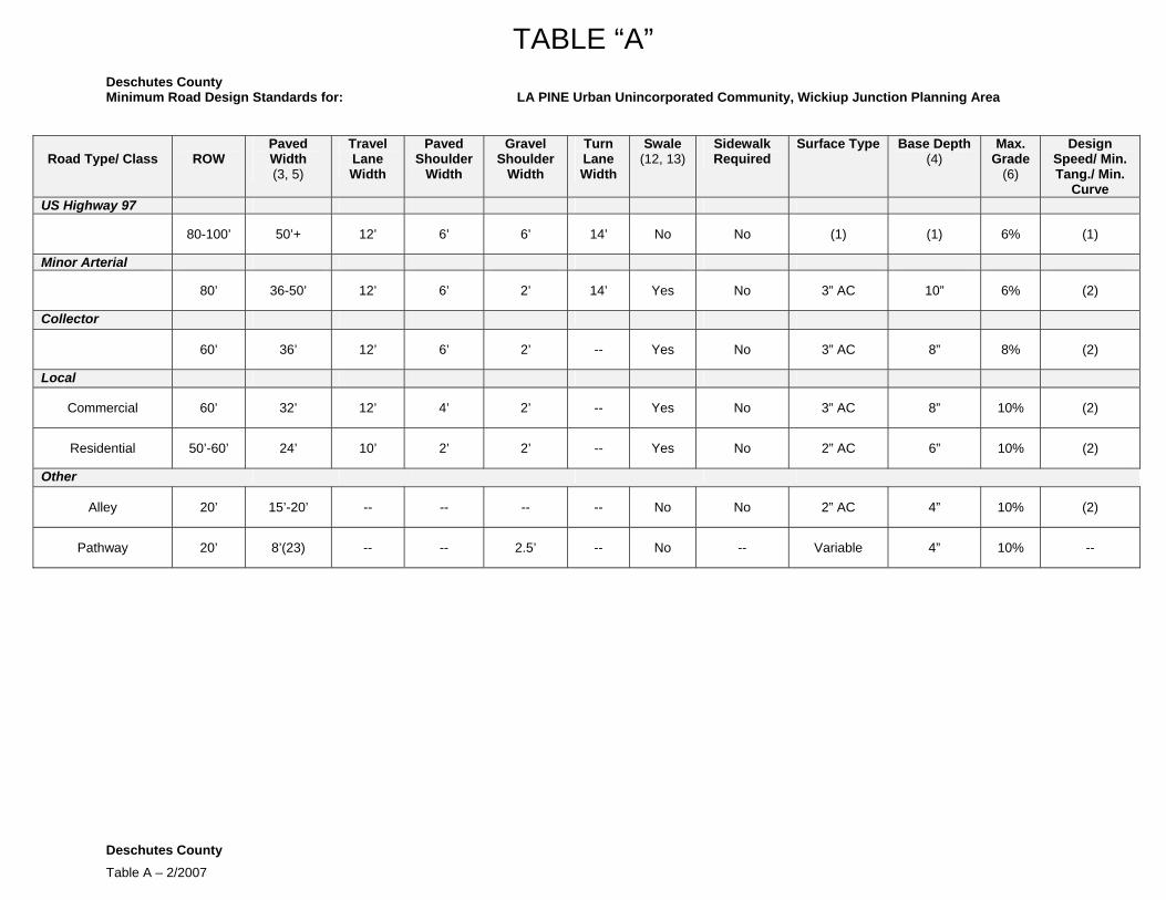
TABLE “A” Deschutes County Minimum Road Design Standards for: LA PINE Urban Unincorporated Community, Wickiup Junction Planning Area
Road Type/ Class
ROW Paved Width (3, 5)
Travel Lane Width
Paved Shoulder
Width
Gravel Shoulder
Width
Turn Lane Width
Swale (12, 13)
Sidewalk Required
Surface Type Base Depth (4)
Max. Grade
(6)
Design Speed/ Min. Tang./ Min.
Curve US Highway 97
80-100’ 50’+ 12’ 6’ 6’ 14’ No No (1) (1) 6% (1)
Minor Arterial
80’ 36-50’ 12’ 6’ 2’ 14’ Yes No 3” AC 10” 6% (2)
Collector
60’ 36’ 12’ 6’ 2’ -- Yes No 3” AC 8” 8% (2)
Local
Commercial 60’ 32’ 12’ 4’ 2’ -- Yes No 3” AC 8” 10% (2)
Residential 50’-60’ 24’ 10’ 2’ 2’ -- Yes No 2” AC 6” 10% (2)
Other
Alley 20’ 15’-20’ -- -- -- -- No No 2” AC 4” 10% (2)
Pathway 20’ 8’(23) -- -- 2.5’ -- No -- Variable 4” 10% --
Deschutes County Table A – 2/2007

TABLE “A” Minimum Road Design Standards for: LA PINE Urban Unincorporated Community, Neighborhood Planning Area
Road Type/Class
ROW
Paved Width (3, 5)
Travel Lane Width
Paved Shoulder
Width (22)
Gravel Shoulder
Width
Turn Lane Width
Swale (12,13)
Sidewalk Required
Surface Type Base Depth (4)
Max. Grade
(6)
Design Speed/ Min. Tang./ Min.
Curve Central Collector
90’ 24’ 12’ -- 2’ -- Yes No (20) 3” AC 10” 6% (2)
Neighborhood Collector
80’ 22’ 11’ -- 2’ -- Yes No (20) 3” AC 8” 8% (2)
Perimeter Collector
60’ 24’ 12’ -- 2’ -- Yes No (20) 3” AC 8” 8% (2)
Local
Commercial 60’ 24’ 12’ -- 2’ -- Yes Yes 3” AC 8” 10% (2)
Residential 60’ 20’ 10’ -- 2’ -- Yes No (20) 2” AC 6” 10% (2)
Other
Alley 20’ 15’ -- -- -- -- No No 2” AC 4” 10% (2)
Pathway 15’ 8’(23) -- -- 2.5’ -- No -- Variable 4” 10% --
Table A – 2/2007

TABLE “A” Deschutes County Minimum Road Design Standards for: TUMALO Unincorporated Community
Road Type/Class
ROW
Paved Width (3, 5)
Travel Lane Width
Paved Shoulder
Width
Gravel Shoulder
Width
Turn Lane Width
Swale (12,13)
Sidewalk Required
Surface Type Base Depth (4)
Max. Grade
(6)
Design Speed/ Min. Tang./ Min.
Curve US Highway 20
80’-100’ 60’ 12’ 4’ 6’ 14’ No No (1) (1) 6% (1)
Collector
Commercial 60’ 30’ 11’ 4’ 2’ 14’ Yes Yes 3” AC 8” 8% (2)
Residential 60’ 36’ 12’ 6’ 2’ 14’ Yes No 3” AC 8” 8% (2)
Local
Commercial 60’ 20’ 10, -- 2’ -- Yes No (15,16) 3” AC 8” 8% (2)
Residential 60’ 20’ 10’ -- 2’ -- Yes No 0-9 or 2” AC 6” 10% (2)
Other
Alley (Commercial) 20’ 20’ -- -- -- -- No No 2” AC 6” 10% (2)
Path/Trail 15’ 6’ unpaved
8’ paved(23)
-- -- 2.5’ (if paved) -- -- -- 2” AC 4” 5% --
Table A – 2/2007
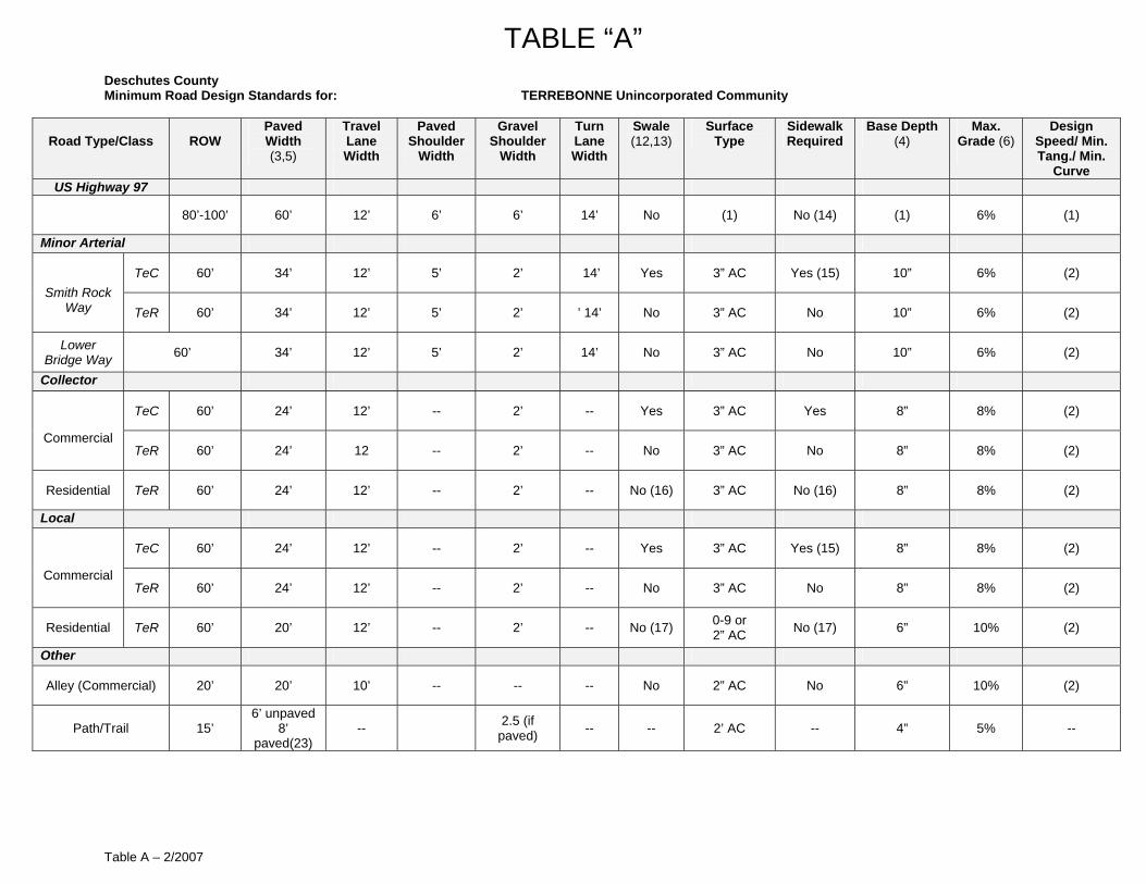
TABLE “A” Deschutes County Minimum Road Design Standards for: TERREBONNE Unincorporated Community
Road Type/Class
ROW Paved Width (3,5)
Travel Lane Width
Paved Shoulder
Width
Gravel Shoulder
Width
Turn Lane Width
Swale (12,13)
Surface Type
Sidewalk Required
Base Depth (4)
Max. Grade (6)
Design Speed/ Min. Tang./ Min.
Curve US Highway 97
80’-100’ 60’ 12’ 6’ 6’ 14’ No (1) No (14) (1) 6% (1)
Minor Arterial
TeC 60’ 34’ 12’ 5’ 2’ 14’ Yes 3” AC Yes (15) 10” 6% (2) Smith Rock
Way TeR 60’ 34’ 12’ 5’ 2’ ’ 14’ No 3” AC No 10” 6% (2)
Lower Bridge Way 60’ 34’ 12’ 5’ 2’ 14’ No 3” AC No 10” 6% (2)
Collector
TeC 60’ 24’ 12’ -- 2’ -- Yes 3” AC Yes 8” 8% (2)
Commercial TeR 60’ 24’ 12 -- 2’ -- No 3” AC No 8” 8% (2)
Residential TeR 60’ 24’ 12’ -- 2’ -- No (16) 3” AC No (16) 8” 8% (2)
Local
TeC 60’ 24’ 12’ -- 2’ -- Yes 3” AC Yes (15) 8” 8% (2)
Commercial TeR 60’ 24’ 12’ -- 2’ -- No 3” AC No 8” 8% (2)
Residential TeR 60’ 20’ 12’ -- 2’ -- No (17) 0-9 or 2” AC No (17) 6” 10% (2)
Other
Alley (Commercial) 20’ 20’ 10’ -- -- -- No 2” AC No 6” 10% (2)
Path/Trail 15’ 6’ unpaved
8’ paved(23)
-- 2.5 (if paved) -- -- 2’ AC -- 4” 5% --
Table A – 2/2007
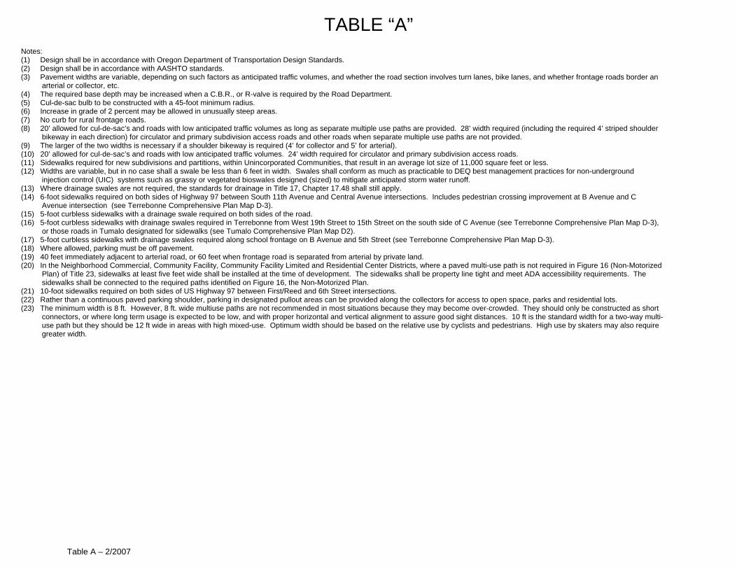
TABLE “A” Notes: (1) Design shall be in accordance with Oregon Department of Transportation Design Standards. (2) Design shall be in accordance with AASHTO standards. (3) Pavement widths are variable, depending on such factors as anticipated traffic volumes, and whether the road section involves turn lanes, bike lanes, and whether frontage roads border an
arterial or collector, etc. (4) The required base depth may be increased when a C.B.R., or R-valve is required by the Road Department. (5) Cul-de-sac bulb to be constructed with a 45-foot minimum radius. (6) Increase in grade of 2 percent may be allowed in unusually steep areas. (7) No curb for rural frontage roads. (8) 20’ allowed for cul-de-sac’s and roads with low anticipated traffic volumes as long as separate multiple use paths are provided. 28’ width required (including the required 4’ striped shoulder
bikeway in each direction) for circulator and primary subdivision access roads and other roads when separate multiple use paths are not provided. (9) The larger of the two widths is necessary if a shoulder bikeway is required (4’ for collector and 5’ for arterial). (10) 20’ allowed for cul-de-sac’s and roads with low anticipated traffic volumes. 24’ width required for circulator and primary subdivision access roads. (11) Sidewalks required for new subdivisions and partitions, within Unincorporated Communities, that result in an average lot size of 11,000 square feet or less. (12) Widths are variable, but in no case shall a swale be less than 6 feet in width. Swales shall conform as much as practicable to DEQ best management practices for non-underground
injection control (UIC) systems such as grassy or vegetated bioswales designed (sized) to mitigate anticipated storm water runoff. (13) Where drainage swales are not required, the standards for drainage in Title 17, Chapter 17.48 shall still apply. (14) 6-foot sidewalks required on both sides of Highway 97 between South 11th Avenue and Central Avenue intersections. Includes pedestrian crossing improvement at B Avenue and C
Avenue intersection (see Terrebonne Comprehensive Plan Map D-3). (15) 5-foot curbless sidewalks with a drainage swale required on both sides of the road. (16) 5-foot curbless sidewalks with drainage swales required in Terrebonne from West 19th Street to 15th Street on the south side of C Avenue (see Terrebonne Comprehensive Plan Map D-3),
or those roads in Tumalo designated for sidewalks (see Tumalo Comprehensive Plan Map D2). (17) 5-foot curbless sidewalks with drainage swales required along school frontage on B Avenue and 5th Street (see Terrebonne Comprehensive Plan Map D-3). (18) Where allowed, parking must be off pavement. (19) 40 feet immediately adjacent to arterial road, or 60 feet when frontage road is separated from arterial by private land. (20) In the Neighborhood Commercial, Community Facility, Community Facility Limited and Residential Center Districts, where a paved multi-use path is not required in Figure 16 (Non-Motorized
Plan) of Title 23, sidewalks at least five feet wide shall be installed at the time of development. The sidewalks shall be property line tight and meet ADA accessibility requirements. The sidewalks shall be connected to the required paths identified on Figure 16, the Non-Motorized Plan.
(21) 10-foot sidewalks required on both sides of US Highway 97 between First/Reed and 6th Street intersections. (22) Rather than a continuous paved parking shoulder, parking in designated pullout areas can be provided along the collectors for access to open space, parks and residential lots. (23) The minimum width is 8 ft. However, 8 ft. wide multiuse paths are not recommended in most situations because they may become over-crowded. They should only be constructed as short
connectors, or where long term usage is expected to be low, and with proper horizontal and vertical alignment to assure good sight distances. 10 ft is the standard width for a two-way multi-use path but they should be 12 ft wide in areas with high mixed-use. Optimum width should be based on the relative use by cyclists and pedestrians. High use by skaters may also require greater width.
Table A – 2/2007
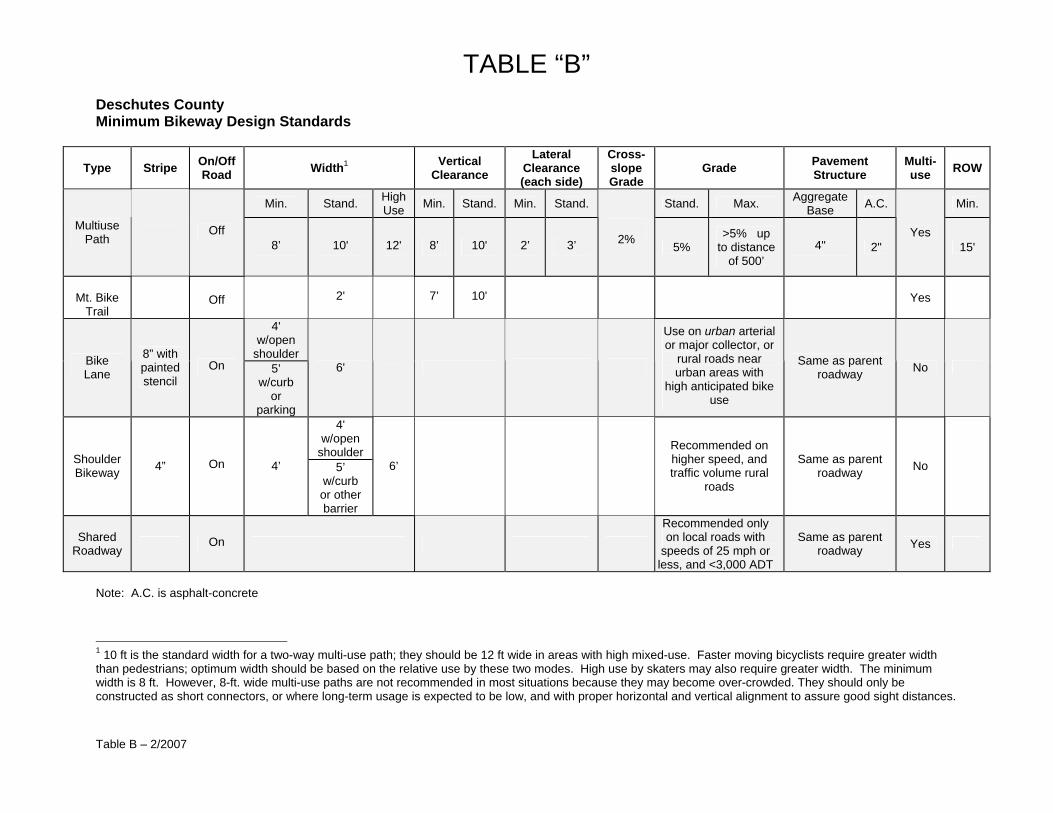
Deschutes County
TABLE “B”
Table B – 2/2007
Minimum Bikeway Design Standards
Type Stripe On/Off Road Width1 Vertical
Clearance Lateral
Clearance (each side)
Cross-slope Grade
Grade Pavement Structure
Multi-use ROW
Min. Stand. High Use Min. Stand. Min. Stand. Stand. Max. Aggregate
Base A.C. Min.
Multiuse Path Off
8’ 10' 12' 8’ 10' 2’ 3’
2% 5% >5% up
to distance of 500’
4" 2" Yes
15'
Mt. Bike
Trail
Off 2' 7’ 10'
Yes
4' w/open
shoulder Bike Lane
8” with painted stencil
On 5’ w/curb
or parking
6'
Use on urban arterial or major collector, or
rural roads near urban areas with
high anticipated bike use
Same as parent roadway No
4' w/open
shoulder Shoulder Bikeway 4” On 4’ 5’
w/curb or other barrier
6’ Recommended on higher speed, and traffic volume rural
roads
Same as parent roadway No
Shared Roadway On
Recommended only on local roads with
speeds of 25 mph or less, and <3,000 ADT
Same as parent roadway Yes
Note: A.C. is asphalt-concrete
1 10 ft is the standard width for a two-way multi-use path; they should be 12 ft wide in areas with high mixed-use. Faster moving bicyclists require greater width than pedestrians; optimum width should be based on the relative use by these two modes. High use by skaters may also require greater width. The minimum width is 8 ft. However, 8-ft. wide multi-use paths are not recommended in most situations because they may become over-crowded. They should only be constructed as short connectors, or where long-term usage is expected to be low, and with proper horizontal and vertical alignment to assure good sight distances.