tompkins county natural resources inventory
TRANSCRIPT
Tompkins CountyNatural Resources Inventory
Prepared by the Tompkins County Planning DepartmentIthaca, New YorkSeptember, 2001
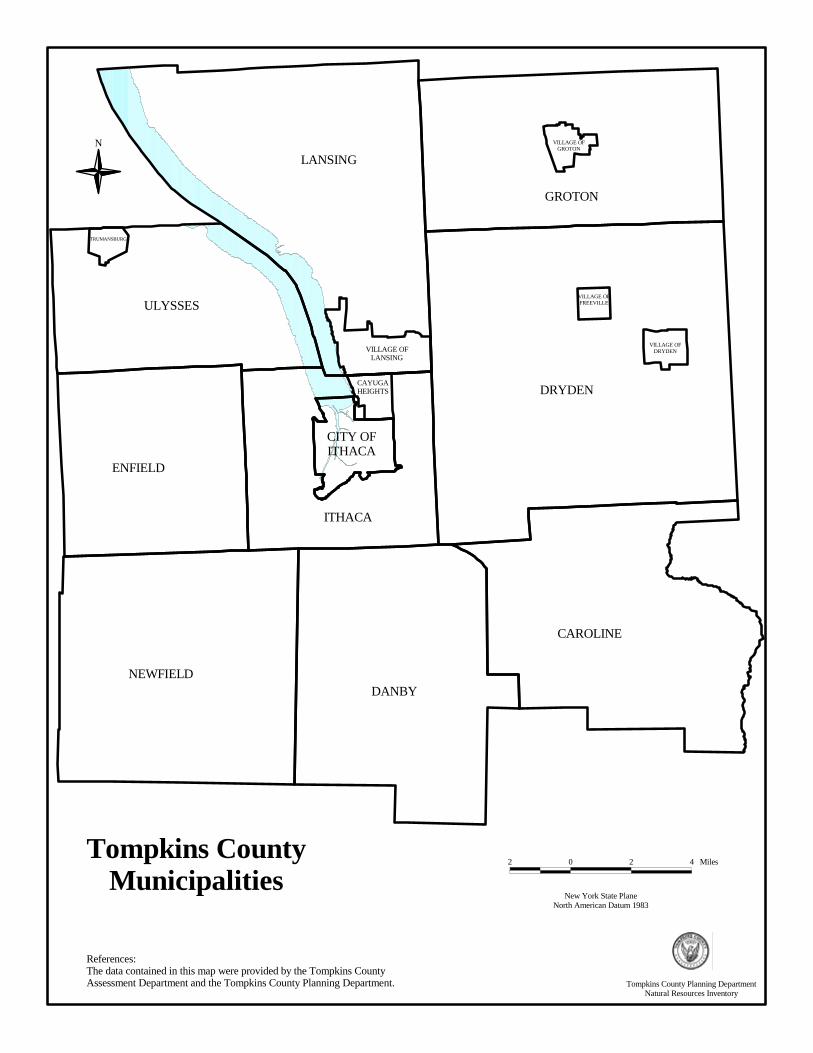
New York State PlaneNorth American Datum 1983
2 0 2 4 Miles
References:The data contained in this map were provided by the Tompkins County Assessment Department and the Tompkins County Planning Department.
N
Tompkins CountyMunicipalities
LANSING
DRYDEN
ITHACA
ENFIELD
NEWFIELDDANBY
CAROLINE
CAYUGAHEIGHTS
VILLAGE OFDRYDEN
VILLAGE OFFREEVILLEULYSSES
VILLAGE OFGROTON
TRUMANSBURG
VILLAGE OFLANSING
GROTON
CITY OFITHACA
Tompkins County Planning DepartmentNatural Resources Inventory
DEDICATION This Tompkins County Natural Resources Inventory is dedicated to Tompkins County Planning Commissioner James W. Hanson, Jr., in recognition of his commitment to protecting the environment and conserving natural resources. Jim’s guidance and enduring support have enabled staff and volunteers to produce documents such as this Tompkins County Natural Resources Inventory and the Unique Natural Areas of Tompkins County. These and other initiatives enhance the ability of communities in Tompkins County to protect their resources and attain a higher quality of life.
ii
TABLE OF CONTENTS
INTRODUCTION...................................................................................................................................... 1
HYDROLOGICAL RESOURCES
Water Bodies............................................................................................................................................. 5
Watersheds................................................................................................................................................ 9
Aquifers ................................................................................................................................................... 12
Wetlands .................................................................................................................................................. 15
Flood Hazard Areas ................................................................................................................................. 20
LAND RESOURCES
Slope and Topography ............................................................................................................................ 23
Soils ......................................................................................................................................................... 26
Bedrock Geology ..................................................................................................................................... 29
Surficial Geology ..................................................................................................................................... 32
ECOLOGICAL RESOURCES
Unique Natural Areas .............................................................................................................................. 35
New York State Parks, Forests, and Wildlife Management Areas .......................................................... 38
Tompkins County Reforestry Lands ........................................................................................................ 41
Important Bird Areas ............................................................................................................................... 43
Natural Heritage Sites .............................................................................................................................. 45
Critical Environmental Areas, National Natural Landmarks,
and New York State Recreational Rivers ............................................................................................ 46
Finger Lakes Land Trust Preserves and Conservation Easements, The Nature Conservancy Preserves,
and Cornell Natural Areas.................................................................................................................... 49
LANDSCAPE ANALYSIS RESOURCES
Aerial Photographs................................................................................................................................... 55
Digital Orthographic Quarter Quadrangles ............................................................................................. 58
Land Use and Land Cover ....................................................................................................................... 60
iii

LIST OF TABLES
WATER BODIES Table 1: Stream Classifications.................................................................................................................... 5
WATERSHEDS Table 2: Watersheds in Tompkins County.................................................................................................. 10
WETLANDS Table 3: Wetlands in Tompkins County ..................................................................................................... 16
FLOOD HAZARD AREAS Table 4: Likelihood of Experiencing at Least One Flood Event ............................................................... 21
UNIQUE NATURAL AREAS Table 5: Unique Natural Areas by Municipality, 1999 .............................................................................. 36
LAND USE AND LAND COVER Table 6: Land Use and Land Cover in Tompkins County .......................................................................... 60
iv
INTRODUCTION What are the Natural Resources in Tompkins County? Located in the Finger Lakes Region of central New York, Tompkins County contains an uncommon mixture of spectacular natural features, a vibrant urban center, internationally renowned academic institutions, and a productive and attractive working landscape. With its mixture of urban, suburban, and rural landscapes, Tompkins County offers a living environment suited to a variety of tastes. Whether bird-watching, going for a walk in the woods, hiking a gorge, fishing in a stream, or boating on the lake, Tompkins County residents enjoy a variety of activities supported by the County’s natural resources. Known for its outstanding natural features, including Cayuga Lake and its associated gorges and waterfalls, Tompkins County promotes its natural resources to prospective new residents and tourists alike. In addition, the County’s natural resources are an important economic resource, supporting agriculture, forestry, and mining operations. The most dominant natural feature in Tompkins County is Cayuga Lake. Cayuga Lake is located in a glacial valley with steep slopes along the lakeshore punctuated by many picturesque gorges. Wall elevations in the gorges can reach 300 feet. The higher elevations of the lake’s tributaries, combined with the steep gorges, produce numerous waterfalls. Extending into the heart of the County, the lake divides the northern portion of the County in two. As the principal water body, about four fifths (80%) of the County’s land area ultimately drains into Cayuga Lake before moving northward, ultimately to Lake Ontario. The southern fifth (20%) of the County drains southward into the Upper Susquehanna River. Cayuga Lake has served an important economic role in the County. In the 19th Century, the Lake was an important link in the transportation route connecting central and southern New York to Buffalo and points west. Today, it serves as a supply for public drinking water and as a major regional recreational resource. The topography of the watershed was formed as the land began uplifting approximately 200 million years ago. At that time, drainage flowed to the south, through the Susquehanna River system. During the Ice Age, two glacial events produced the deep gorges that became the Finger Lakes. The retreat of the second glacier resulted in the reversal of drainage in the watershed from the south to the north. This glacial action resulted in the creation of the relatively flat lands in the northern portion of the County (in Ulysses, Lansing, and Groton) and the steep hills and valleys of the south (in Newfield, Danby, and Caroline). With its varied topography and landforms, the County also contains a number of interesting ecological communities, including streams, lakes, ponds, marshes, meadows, fens, forests, swamps, and cliffs. With the presence of Cornell University and its strong natural resource program, and a local community of outdoor enthusiasts, many important natural areas have been identified in the County. Nearly 200 such areas have been identified in Unique Natural Areas Inventory of Tompkins County. Tompkins County is also home to a National Natural Landmark (McLean Bogs) located in the Town of Dryden. In addition, the County has one Recreational River (a portion of Fall Creek), one Critical Environmental Area (Coy Glen), four State Parks, many State Forests, several Audubon-designated Important Bird Areas, and a preserve protected by the local Finger Lakes Land Trust (Lindsay-Parsons Biodiversity Preserve) for the study and identification of naturally occurring medicinal chemicals. What is a Natural Resources Inventory? A Natural Resources Inventory is a document that inventories the natural resources of an area, collects the data in a usable format and interprets the findings. While an inventory of a single parcel of land might be quite specific and detailed, a countywide Natural Resources Inventory is, by necessity, more generalized.
1

The primary purpose of this Natural Resources Inventory is to provide data that can form a basis for municipal and county planning; it provides basic data for the preparation of plans, information to review proposed development plans, and data to assist in completing environmental assessment forms. It also provides a compendium of facts about the County for general information. Why Should Natural Resources be Protected? As our society has become more mobile and the population of Tompkins County has been steadily growing, the County's natural resources are experiencing increased pressure from development. Some communities have already experienced negative consequences from this pressure, including wildlife displacement, loss of recreation corridors and scenic vistas, surface and groundwater contamination, and increased erosion and flooding. Protecting environmental quality is a matter of choices and tradeoffs. It is generally recognized that homes, factories, and highways have to be built, trees must occasionally be cut down, wastes must be disposed of, etc. It is not a matter of choosing either to proceed with the project or to protect the environment -- but rather to consider what environmental impacts are involved, are they worth the result, and are there other, less damaging ways the same or similar results can be achieved? It is hoped that this document will help the people and public officials of Tompkins County make informed choices. Since much development is irreversible, planning is very important. Long-term planning is one way to minimize the short-term exploitation of the resource base that results from "quick fixes" to localized problems and from competition for resources. Planning at the local, regional, and state levels provides individual municipalities with a rational system for guiding development with respect to the distribution and value of natural resources. How Can Natural Resources be Protected? The Natural Resources Inventory identifies some of the natural resources located in Tompkins County. This is the first step in protecting those resources. Private landowners, government agencies, and conservation organizations can use this knowledge to protect the most important of these resources. There are several major approaches to protecting natural resources. This is not meant to be an all-inclusive description of land protection mechanisms, but an overview of the types of options currently in use. Many books are published which deal extensively with the benefits and costs of various land protection strategies.
Non-Regulatory Tools Acquisition Acquisition with the goal of resource preservation is the surest way of protecting natural resources. Acquiring title and all rights to land through purchase (fee simple acquisition) allows the organization or individual acquiring the property full authority (within the bounds of laws and regulations) over the future use and management of the property’s resources. Local governments and private conservation organizations, like land trusts, are those most likely to use this technique. In addition, some landowners choose to donate their land to these organizations, rather than selling the property. Less than fee-simple acquisition is a more common technique used to protect natural resources. The acquisition of conservation easements (through purchase or donation from a willing seller) is used by land trusts and municipalities to restrict the type and amount of development permitted on a particular parcel of land. The Purchase of Development Rights on agricultural lands is an example of a conservation easement program. Other Non-Regulatory Tools There are several other non-regulatory methods available to help protect natural resources. The most common is to raise local awareness of the value and location of important natural resources through local planning efforts. Goals for protecting natural resources can be defined in a community’s
2

comprehensive plan. Natural resource protection can also be addressed in open space and recreation plans, or in plans for a particular resource, such as a watershed protection plan. The identification and designation of particularly important natural resources can help preserve them by educating the local population on the resources’ importance. One example of this type of effort is the work done by the Tompkins County Environmental Management Council to identify and describe the Unique Natural Areas in the County. Although this designation carries no regulatory authority, many state and local agencies and organizations use the Unique Natural Areas Inventory of Tompkins County to assist in the review of development proposals and in the preparation of environmental review documents. Another example is the State’s Agricultural District program. Once a county designates land as being in an agricultural district, state protections for the operation of farms are triggered, making it easier to protect those agricultural resources. Natural resource education programs are another way to help raise awareness of the importance of natural resources and interest in protecting those resources. A local example is the Cayuga Nature Center’s series of programs for children and adults. Regulatory Tools There are also many regulatory tools available to local municipalities to help protect natural resources. Communities can adopt zoning and subdivision regulations that provide for the protection of natural resources. Specific regulatory techniques for protecting resources include: �� Zoning and Subdivision Ordinances – used to protect the public health, safety, and general
welfare. �� Buffer Requirements – establishes minimum distances between a development and a selected
natural feature. �� Clustering Requirements – places residential units on a portion of a site to protect a contiguous
area of open space or unique feature. �� Performance Zoning – unlike traditional zoning, performance zoning determines whether a land
use is permitted based on an assessment of potential impacts. �� Preservation Overlay Zones – geographic areas where more restrictive development regulations
are enforced to protect valued natural resources. �� Park Dedications – requires developers to contribute land, or cash in lieu of land, to provide for
the open space and recreation needs of the subdivision’s residents. �� Transfer of Development Rights – landowners in designated preservation areas may sell
development rights to allow increased density in other areas of the community. �� Purchase of Development Rights – landowners in designated preservation areas may sell
development rights for cash to a government or appropriate organization. �� Environmental Quality Zones – requires that development in certain areas meet specific
thresholds for environmental impacts, such as mitigating a set percentage of wetland losses. How is This Natural Resources Inventory Organized? The following chapters describe the natural resources data sets of Tompkins County. They have been grouped into four resource categories: hydrological, land, ecological, and landscape analysis.
3

These chapters explain what the data are, how they are important, where they are located in Tompkins County, and how to get more information on the topic. Maps show where these natural resources are located. Many of these data sets can be downloaded directly from the Cornell University Geographic Information Repository Website (http://cugir.mannlib.cornell.edu/). Some of these digital data sets can be purchased directly from the United States Geological Survey or the NYS Department of Environmental Conservation, or downloaded from their websites. Some data sets have limitations and none of them are guaranteed by their originators to be free of errors. Many are not intended to be used to review individual parcels, but are appropriate for larger-scale planning efforts. Geographic Information Systems (GIS) enable the analysis and understanding of the natural resources in Tompkins County, and assist planners in managing development while protecting those resources. GIS is a computer software system that allows the overlay of geographic data sets so that the relationships between these data may be analyzed and evaluated.
4

WATER BODIES Why are Water Bodies Important? Tompkins County is dominated by significant water bodies (lakes, ponds, rivers, and streams) that are critical to public health and the economic and environmental well being of this area. Economic and environmental activities dependent on the integrity of local water bodies and water supplies include tourism, agriculture, industry, recreation, education and research, and real estate. Although wetlands are important components of environmental and economic systems, federal and state agencies consider wetlands to be distinct from water bodies for regulatory purposes. Although water bodies and water supplies are abundant in Tompkins County, certain activities can adversely affect the ecological balance within water bodies, impairing their current and potential economic and environmental functions. Threats to local water supplies include both point source pollution (often thought of as a single pipe draining a water body) and nonpoint source pollution (which is broader in nature and originate from construction, agriculture, parking lot and street runoff, stormwater runoff, on-site wastewater systems, and commercial and residential activities). How are Water Bodies Regulated? Federal and state agencies, such as the New York State Department of Environmental Conservation (DEC) and United States Army Corps of Engineers (Army Corps), require permits for activities that might affect or disturb a water body and/or its banks. The stringency of these permits corresponds with the DEC classification assigned to the water body (see below) and may range from a general, or unified, permit to a permit tailored to the specific site and type of work conducted. Regulated activities might include streambank maintenance, construction, flood protection and mitigation, dredging, placing fill, and certain agricultural practices. Commercial, industrial, and agricultural activities that discharge to a water body require a State Pollution Discharge Elimination System (SPDES) permit. This permit is required for a broad range of activities, including the discharge of wastewater, stormwater, or chemical and thermal emissions from municipal treatment plants, industrial plants, utilities, large subdivisions, apartment complexes, and confined animal feeding operations. Prior to conducting stream-related work or discharging wastewater, the Region 7 Office of the DEC or the Army Corps Buffalo District should be contacted to obtain the necessary approvals and permits. Each of these agencies will automatically forward permit applications to the other, and each agency will contact the applicant if additional permits and/or paperwork are needed. How are Water Bodies Classified? The DEC has assigned most water bodies within the state a letter based on their existing or expected “best use.” The most pristine waters are assigned a classification of AA; while the most degraded waters are assigned a classification of D. Table 1: Stream Classifications Class Best Use AA Drinking (after chlorination) A Drinking (after chlorination and filtration) B Bathing C (T) Fishing (trout) C Fishing D Secondary contact recreation Source: New York State Department of Environmental Conservation
5
Additional classifications of “T” or “TS” can be added if a water body has sufficient amounts of dissolved oxygen to support trout and trout spawning. Water bodies that are designated as “C (T)” or higher (i.e., “C (TS)”, “B”, or “A”) are collectively referred to as "protected streams," and are subject to additional regulations. Periodically, the DEC publishes the Priority Waterbodies List (PWL), which includes a list of water bodies that do not meet their designated “best use” classification. A data sheet that describes the conditions, causes, and sources of water quality degradation for each of the respective listings is also included in the PWL. The PWL is used by the DEC and other agencies as a primary resource for water resources management and funding. Water Bodies in Tompkins County Many of the water bodies of Tompkins County (streams, lakes, and ponds) are designated as protected streams due to their importance as drinking water supplies or fish habitat. See the following map for the location of protected streams in Tompkins County. Fish resources are a key factor in determining water body classifications because they are the top of the food chain in aquatic habitats. As such, fish can be used as an indicator of the overall quality of an aquatic ecosystem. They are highly vulnerable, both directly and indirectly, to changes in their environment. They can be directly affected by physical and chemical changes in the water, and indirectly affected when changes in the environment affect their food sources or the temperature and turbidity of their habitat. Cayuga Lake includes two interrelated assemblages of species, one in the shallow (littoral) zone and the second in the deep-water zone. In Tompkins County, the shallow zone is limited to the southern lake basin and a narrow fringe along the lake margins where light reaches the bottom. The shallow zone is home to a warm water fish community dominated by Smallmouth Bass. Other important predator fish in the shallow-water community include Largemouth Bass and Northern Pike. These species prey on Yellow Perch, Pumpkinseeds, Bluegills, Rock Bass, and Minnows. Southern Cayuga Lake also supports a spawning population of White Suckers. Lake Trout, Rainbow Trout, Brown Trout, and Landlocked Salmon are the dominant predators in the deep-water community. Of these salmonids, only the Lake Trout is native to Cayuga Lake. Populations of the Brown and Rainbow Trout, Landlocked Salmon, and Lake Sturgeon are maintained (or, in the case of Rainbow Trout, supplemented) by stocking. Juvenile salmonids prey on zooplankton. The quantity of zooplankton is considered to be the limiting factor for the growth and survival of Cayuga Lake’s most important sport fish, stocked juvenile lake trout. The Alewife is the predominant forage species. Other prey species include Rainbow Smelt, Troutperch, and Slimy Sculpin. The New York State Department of Environmental Conservation (DEC) has designated several creeks in Tompkins County as protected partially for the purposes of fish habitat. The DEC stocks these creeks with various species of fish. Buttermilk Creek, Enfield Creek, Fall Creek, Salmon Creek, Six Mile Creek, and Virgil Creek are stocked with Brown Trout. Rainbow Trout are stocked in Salmon Creek, and Landlocked Salmon are stocked in Owasco Inlet. Maps and Data Information about protected streams in Tompkins County was copied from the DEC Region 7 Protected Stream maps. For a map of this information, in paper or digital format, contact the Tompkins County Planning Department. The PWL and maps of protected streams can also be viewed at the Tompkins County Soil and Water Conservation District. For information about permitting, contact the Region 7 DEC Office or the Army
6

Corps of Engineers. Additional information about the PWL can be obtained from the New York State Department of Environmental Conservation (DEC)’s Division of Water. Resources and References Army Corps of Engineers, Buffalo District (Attention: Regulatory Branch), 1776 Niagara St., Buffalo, NY, 14207-3199, 716-879-4330. New York State Department of Environmental Conservation, Div. of Water, 625 Broadway, Albany, NY 12233, 518-402-8233: http://www.dec.state.ny.us/website/regs/ch10.htm http://www.dec.state.ny.us/website/dcs/streamprotection/index.html New York State Department of Environmental Conservation, Region 7 Office, 615 Erie Blvd. West, Syracuse, NY 13204-2400, 315-426-7403. Tompkins County Planning Department, 121 East Court Street, Ithaca, NY 14850, 607-274-5560. Tompkins County GIS Program, Information Technical Services, 128 East Buffalo Street, Ithaca, NY 14850, 607-274-5418. http://www.tompkins-co.org/gis Tompkins County Soil and Water Conservation District, 903 Hanshaw Rd, Ithaca, NY 14850, 607-257-2340.
7
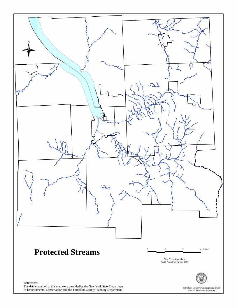
Protected Streams
N
References:The data contained in this map were provided by the New York State Department of Environmental Conservation and the Tompkins County Planning Department.
New York State PlaneNorth American Datum 1983
2 0 2 4 Miles
Tompkins County Planning DepartmentNatural Resources Inventory
WATERSHEDS What is a Watershed? A watershed is the land area that contributes water to a given point, such as a stream or lake. Contributing sources of water for a watershed include (but are not limited to) springs, streams, seeps, ditches, culverts, marshes, wetlands, swamps, and ponds. Eventually, all surface water, some groundwater resources, and precipitation falling within a watershed, drain into a single receiving water body such as a stream, river, lake, or wetland. A watershed boundary is usually delineated by connecting the highest elevation points in the area. Watersheds exist at various scales within a hierarchical structure. Gullies and ravines trickle into streams, which in turn feed into larger streams or rivers. Each of these water bodies (gully, ravine, stream, etc.) drains its own particular watershed so that larger watersheds are comprised of several smaller watersheds. For example, the Virgil Creek watershed flows into the Fall Creek watershed, which is contained within the larger Cayuga Lake watershed. While the term watershed is often used interchangeably with “drainage basin”, the term drainage basin usually refers to a larger watershed such as the Susquehanna River Drainage Basin or the Lake Ontario Drainage Basin. Why are Watersheds Important? Land use throughout a watershed (or the commercial, industrial, agricultural, and/or residential activities a land area can support) and the availability of reliable water sources within a watershed are directly related. That is, the land use in a particular area is often determined by the availability of reliable water supplies; and the single most important determinant of the quality, quantity, and availability of local water resources is land use. Because of this dynamic relationship between water and land use, the characteristics of the entire watershed must be considered when addressing water quality and water quantity issues, including such factors as the amount of impervious surface and effectiveness of local land management practices. Additionally, the critical influence and impact of water on important ecological and economic systems (such as provision of drinking water, flooding, recreation, and future economic growth) make watersheds increasingly popular and important management and planning units. Are Watersheds Regulated? Although there are no regulations associated with a watershed, state and federal agencies look favorably on water-related management and planning processes that utilize the principles and concepts of watershed management. Watersheds in Tompkins County The land area within Tompkins County drains into two major river drainage basins: the Oswego River basin, which drains north to Lake Ontario, and the Susquehanna River basin, which drains south to the Chesapeake Bay. Over 383 square miles (245,545 acres) of Tompkins County drain into the Oswego River basin directly or via Cayuga Lake. Over 96 square miles (61,459 acres) of Tompkins County drain into the Susquehanna River. Tompkins County is a major contributor to the Cayuga Lake water system, as the County comprises over half of the total land area in the Cayuga Lake watershed.
9
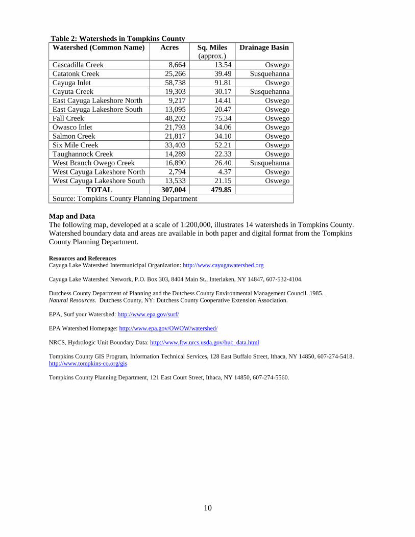
Table 2: Watersheds in Tompkins County Watershed (Common Name) Acres Sq. Miles
(approx.) Drainage Basin
Cascadilla Creek 8,664 13.54 OswegoCatatonk Creek 25,266 39.49 SusquehannaCayuga Inlet 58,738 91.81 OswegoCayuta Creek 19,303 30.17 SusquehannaEast Cayuga Lakeshore North 9,217 14.41 OswegoEast Cayuga Lakeshore South 13,095 20.47 OswegoFall Creek 48,202 75.34 OswegoOwasco Inlet 21,793 34.06 OswegoSalmon Creek 21,817 34.10 OswegoSix Mile Creek 33,403 52.21 OswegoTaughannock Creek 14,289 22.33 OswegoWest Branch Owego Creek 16,890 26.40 SusquehannaWest Cayuga Lakeshore North 2,794 4.37 OswegoWest Cayuga Lakeshore South 13,533 21.15 Oswego
TOTAL 307,004 479.85 Source: Tompkins County Planning Department
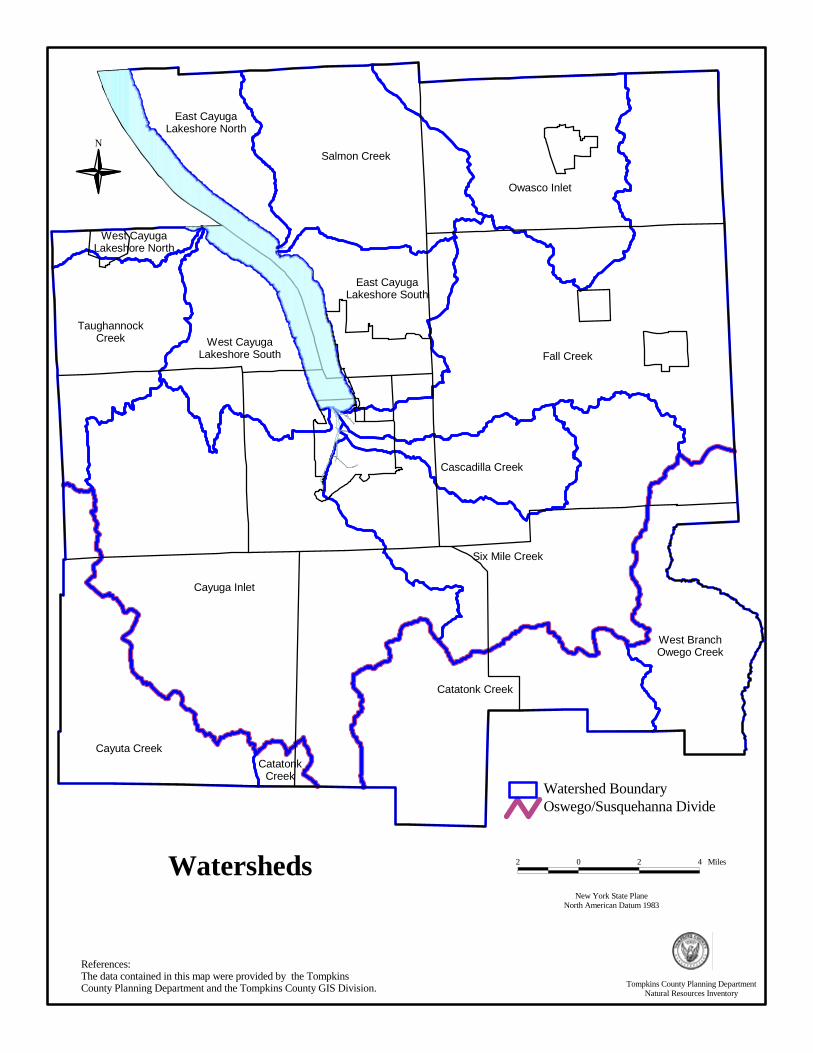
Map and Data The following map, developed at a scale of 1:200,000, illustrates 14 watersheds in Tompkins County. Watershed boundary data and areas are available in both paper and digital format from the Tompkins County Planning Department. Resources and References Cayuga Lake Watershed Intermunicipal Organization: http://www.cayugawatershed.org Cayuga Lake Watershed Network, P.O. Box 303, 8404 Main St., Interlaken, NY 14847, 607-532-4104. Dutchess County Department of Planning and the Dutchess County Environmental Management Council. 1985. Natural Resources. Dutchess County, NY: Dutchess County Cooperative Extension Association. EPA, Surf your Watershed: http://www.epa.gov/surf/ EPA Watershed Homepage: http://www.epa.gov/OWOW/watershed/ NRCS, Hydrologic Unit Boundary Data: http://www.ftw.nrcs.usda.gov/huc_data.html Tompkins County GIS Program, Information Technical Services, 128 East Buffalo Street, Ithaca, NY 14850, 607-274-5418. http://www.tompkins-co.org/gis Tompkins County Planning Department, 121 East Court Street, Ithaca, NY 14850, 607-274-5560.
10
References:The data contained in this map were provided by the Tompkins County Planning Department and the Tompkins County GIS Division.
N
New York State PlaneNorth American Datum 1983
2 0 2 4 MilesWatersheds
Fall Creek
Cayuga Inlet
Six Mile Creek
Owasco Inlet
Salmon Creek
Catatonk Creek
Cayuta Creek
TaughannockCreek
West BranchOwego Creek
Cascadilla Creek
West CayugaLakeshore South
East CayugaLakeshore South
East CayugaLakeshore North
West CayugaLakeshore North
CatatonkCreek
Oswego/Susquehanna DivideWatershed Boundary
Tompkins County Planning DepartmentNatural Resources Inventory
AQUIFERS
What is an Aquifer? Aquifers are geologic formations beneath the Earth’s surface that store and yield usable amounts of groundwater. One or more aquifers can lie beneath any given point on the Earth’s surface; and the location, size, capacity, depth, and flow characteristics of an aquifer are directly related to the geology and hydrology of the particular aquifer and its recharge area. (See definition of recharge area below.) Aquifers are usually described as confined or unconfined. Typically, confined aquifers are covered with, or consist of, less permeable substances such as clay or contiguous shale. Unconfined aquifers consist of unconsolidated materials such as sand and gravel, which allow substances to easily percolate from the surface to the aquifers below. The uppermost boundary of surficial aquifers (those closest to the Earth’s surface) is defined by the water table, which is where the spaces in unconsolidated sediments and the openings in bedrock are fully saturated. The spaces between soil and rock particles in the unsaturated zone, located above the water table, are only partially occupied by water. The water table rises and falls depending on the rates of groundwater recharge and discharge and the capacity of the aquifer. Aquifers can be replenished – or recharged – by the infiltration of precipitation and surface water runoff through soil, as well as by the intermixing of surface water resources such as streams and creeks. The land area that contributes to this infiltration is called a recharge area. Recharge areas may replenish aquifers directly beneath them (as in the case of unconfined or surficial aquifers) or they may recharge aquifers far away (as in the case of confined aquifers). Why are Aquifers Important? Aquifers are an important source of water for residential, commercial, and industrial uses. Almost half of all Tompkins County residents rely on groundwater to supply their drinking water needs. Additionally, in central New York, groundwater typically contributes more than half of the total annual flow to local streams and creeks. Because aquifers are replenished by the infiltration of surface water, impervious surfaces (pavement from roads or parking lots, roofs, building footprints, etc.) decrease recharge areas and threaten aquifers by inhibiting infiltration of precipitation and surface water through the soil. Any contaminant contained in or near an aquifer, and/or its recharge area may potentially contaminate the aquifer. Potential contaminants include bacteria and pathogens leaching from septic systems; gas, salt and oil washed from parking lots; fertilizers; pesticides; hazardous or toxic waste spills; and petroleum or oil leaking from underground storage tanks. Unlike surface water, which flushes contaminants downstream relatively quickly, groundwater in aquifers migrates relatively slowly and can take several years or decades to move from the point of origin to the point of discharge. Once degraded, an aquifer can become unusable, and oftentimes remediation is not technologically or economically feasible. Moreover, because of groundwater and surface water interactions, contamination in an aquifer may eventually contaminate surface water as well. The quantity of water contained within an aquifer, and the aquifer’s ability to serve as a reliable supply of water, must also be considered. Generally, an aquifer’s geology, retention, and recharge characteristics determine the quantity of water available. When water is withdrawn at a rate faster than it is recharged, the aquifer can be depleted. Generally, this occurs when too many wells withdraw water from an aquifer. Aquifers in Tompkins County The process of glaciation and the subsequent deposition of coarse sand and gravel deposits heavily influenced the location, size, and capacity of aquifers in Tompkins County. As a result, several small
12

discontinuous local aquifers in Tompkins County were created that support limited numbers of wells while others supply vast quantities of water. The main aquifers in Tompkins County are located in the major valleys that are comprised of sand and gravel, such as the Cayuga Inlet valley, upper portions of the Six Mile Creek valley, and portions of the Fall Creek valley. Bedrock aquifers (interlayered sandstones, siltstones, and limestones) typically yield much less water than sand and gravel aquifers. Although bedrock aquifers may be sufficient to supply individual residential units and small farms, the water may be heavily mineralized and relatively unreliable. Maps and Data The following surficial aquifer map, developed at a scale of 1:24,000, indicates the general location of large unconsolidated aquifers in Tompkins County. This map is not intended to be used for detailed site evaluations, as the determination of precise aquifer locations and characteristics requires additional evaluation. To construct this map, the U.S. Geological Survey (USGS) inventoried well data and well-boring logs to identify the extent, depth, and material characteristics of the surficial aquifers in the County. To get a copy of a digital file or a paper map of the surficial aquifers in Tompkins County, contact the Tompkins County Planning Department or the local USGS Office. Resources and References Miller, Todd S. Sand and Gravel Aquifers of Schuyler County, New York. 1990. U.S. Department of Energy, USGS, Water-Resources Investig.Report 90-4073. Tompkins County Planning Department, 121 E. Court Street, Ithaca, NY 14850, 607-274-5560. U.S. Geological Survey (USGS), 30 Brown Road, Ithaca, New York 14850, 607-266-0217. Winter, T.C., J.W. Harvey, O.L. Franke and W.M. Malley. 1998. Ground Water and Surface Water: A Single Resource. USGS Circular.
13
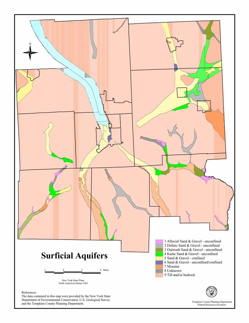
Surficial Aquifers2 0 2 4 Miles
New York State PlaneNorth American Datum 1983
N
References:The data contained in this map were provided by the New York State Department of Environmental Conservation, U.S. Geological Survey and the Tompkins County Planning Department.
1 Alluvial Sand & Gravel - unconfined2 Deltaic Sand & Gravel - unconfined3 Outwash Sand & Gravel - unconfined4 Kame Sand & Gravel - unconfined5 Sand & Gravel - confined6 Sand & Gravel - unconfined/confined7 Moraine8 Unknown9 Till and/or bedrock
Tompkins County Planning DepartmentNatural Resources Inventory

WETLANDS
What is a Wetland? Wetlands, according to the United States Army Corps of Engineers (Army Corps), are “those areas that are inundated or saturated by surface or ground water at a frequency and duration sufficient to support, and that under normal circumstances do support, a prevalence of vegetation typically adapted for life in saturated soil conditions. Wetlands generally include swamps, marshes, bogs, wet meadows, and similar areas.” According to the New York State Department of Environmental Conservation (DEC), “Freshwater wetlands are those areas of land and water that support a preponderance of characteristic wetlands plants that out-compete upland plants because of the presence of wetlands hydrology (such as prolonged flooding) or hydric (wet) soils. Freshwater wetlands commonly include marshes, swamps, bogs, and fens.” Wetlands such as swamps and marshes are often easily recognizable, but some wetlands, such as forested wetlands and wet meadows, are not obvious because they are dry during part of the year. Why are Wetlands Important? Wetlands are a critical component of natural ecosystems and provide a variety of benefits such as: �� filtering harmful toxins, nutrients, and sediment from surface and stormwater runoff; �� storing floodwaters and reducing the magnitude of flood events; and �� providing valuable habitat for a diverse array of flora and fauna, including many rare, threatened, or
endangered species. The recreational uses associated with wetlands are also very diverse and include birdwatching, hunting, and fishing, all of which provide direct economic benefits to local communities. Because wetlands are crucially important both economically and environmentally, they are highly regulated by the Army Corps and the DEC. How are Wetlands Regulated? The National Wetlands Inventory was developed by analyzing aerial photographs and can be used to locate wetlands that are at least one acre in size, however, locations of wetlands should be verified by the Army Corps. Additionally, the Army Corps issues wetland permits for the placement of fill or dredge materials and the construction of certain structures in waterways (navigable and non-navigable) and wetlands. Disturbances to wetlands must be mitigated in accordance with Army Corps regulations. The Army Corps permit required for activities within a wetland, and the amount of wetlands mitigation required, vary depending on the type of project proposed and the area of wetland impacted. The DEC regulates wetlands that are 12.4 acres or larger in size (this is based on the metric system: 12.4 acres = 5 hectares). For any work occurring within a wetland or within 100 feet of a wetland boundary, the DEC requires that a wetlands permit be obtained. Prior to conducting work in or near a wetland, the Region 7 Office of the DEC or the Army Corps Buffalo District should be contacted to obtain the necessary approvals and permits. Each of these agencies will automatically forward permit applications to the other, and each agency will contact the applicant if additional permits and/or paperwork are needed. If permits are not obtained or wetlands are improperly altered, the Army Corps and the DEC have the authority to levy fines. How are Wetlands Classified? The DEC classifies wetlands according to their respective functions, values, and benefits. Of the four classes of wetlands, Class I wetlands are the most valuable and are subject to the most stringent standards. The Army Corps classifies wetlands only according to their species composition.
15

Wetlands in Tompkins County Tompkins County contains both NYS DEC Freshwater Wetlands (as determined by the DEC) and National Wetlands (as determined by the U.S. Fish and Wildlife Service) as shown in the following tables: Table 3: Wetlands in Tompkins County Municipality
Acres of NYS DEC Freshwater
Wetlands
Percent of Municipal Land
Acres of National Wetlands
Percent of Municipal Land
City of Ithaca 27.295 0.70 470.11 12.08Town of Caroline 554.890 1.57 1,020.92 2.90Town of Danby 935.900 2.71 1,186.73 3.44Town of Dryden 2,102.970 3.49 3,401.03 5.93Town of Enfield 162.347 0.69 694.56 2.94Town of Groton 728.168 2.30 1,486.83 4.79Town of Ithaca 75.948 0.39 1,129.57 5.83Town of Lansing 596.263 1.33 6,840.56 15.50Town of Newfield 230.466 0.61 526.68 1.39Town of Ulysses 75.267 0.32 3,046.19 13.01Vil. of Cayuga Hgts 0.000 0.00 62.66 5.59Village of Dryden 39.830 3.83 111.92 10.77Village of Freeville 43.850 6.28 22.98 3.29Village of Groton 39.420 3.70 101.03 9.49Village of Lansing 18.850 0.65 30.25 1.04Vil. of Trumansburg 0.000 0.00 0.05 0.00Total Tompkins Co. 5,631.464 1.75 19,803.18 6.78Source: Tompkins County Planning Department, based on USFWS data NOTE: The NYS DEC Freshwater Wetlands and the National Wetlands Inventory data above includes Cayuga Lake in the total number of municipal acres listed and is factored into the calculation for “Percent of Municipal Land”. Maps and Data The following NYS DEC Freshwater Wetlands and National Wetlands Inventory maps were developed at a scale of 1:24,000 and indicate the general location of wetlands in Tompkins County. Although the Army Corps and the DEC create and periodically update wetlands maps, these maps are developed for use at a scale of 1:200,000 and are best used as an indicator that wetlands are present, and that an on-ground, site-specific investigation by a qualified wetland specialist (Army Corps Engineer or private consultant) is warranted. Many wetlands do not appear on wetland maps, so if land appears to be wet, or has typical wetland plants or soils, landowners should call the Army Corps or the DEC prior to altering the land to avoid wetland destruction and possible fines. For digital and paper copies of federal and state wetlands, contact the Tompkins County Planning Department or the U.S. Army Corps of Engineers. For information about the origin of the wetlands data (metadata), contact the Cornell University Geospatial Information Repository (CUGIR). For questions about wetlands on active farmlands or the Wetlands Reserve Program (which makes payment to landowners for establishing wetland easements on their agricultural property), contact the USDA Natural Resources Conservation Service, Ithaca Office.
16
Resources and References Cornell University Geospatial Information Repository (CUGIR) http://cugir.mannlib.cornell.edu/ Mitsch, W.J. and J.G. Gosselink. 1986. Wetlands. New York: Van Nostrand Reinhold New York State Department of Environmental Conservation http://www.dec.state.ny.us/website/dcs/freshwet/freshwet01.html. New York State Department of Environmental Conservation, Region 7 Office, 615 Erie Blvd. West, Syracuse, NY 13204-2400, 315-426-7403. Tompkins County Planning Department, 121 East Court Street, Ithaca, NY 14850, 607-274-5560. U.S. Army Corps of Engineers: http://www.usace.army.mil/inet/functions/cw/cecwo/reg/techbio.htm U.S. Army Corps of Engineers, Buffalo District, Regulatory Branch, 1776 Niagara Street, Buffalo, NY 14207, 716-879-4330 NYS Department of Environmental Conservation, Division of Environmental Permits, P.O. Box 1285, Fisher Avenue, Cortland, NY 13045-1090, 607-753-3095 http://www.lrb.usace.army.mil U.S. Fish and Wildlife Service, Division of Habitat Conservation, National Wetlands Inventory: http://www.nwi.fws.gov/ USDA Natural Resources Conservation Service (NRCS), Ithaca Office, 903 Hanshaw Rd., Ithaca, NY 14850, 607-257-3820. USDA / NRCS, Wetlands Reserve Program: http://www.wl.fb-net.org/ and Wetland Science Institute: http://www.pwrc.usgs.gov/WLI/
17

National Wetlands Inventory
N
References:The data contained in this map were provided by the US Department of Interior Fish and Wildlife Service and the Tompkins County Planning Department.
New York State PlaneNorth American Datum 1983
2 0 2 4 Miles
Tompkins County Planning DepartmentNatural Resources Inventory

References:The data contained in this map were provided by the New York State Department of Environmental Conservation and the Tompkins County Planning Department.
N
New York State PlaneNorth American Datum 1983
2 0 2 4 Miles
New York State Freshwater Wetlands
Tompkins County Planning DepartmentNatural Resources Inventory
FLOOD HAZARD AREAS What are Flood Hazard Areas? Flood Hazard Areas (FHA) are areas that the Federal Emergency Management Association (FEMA) has determined to be vulnerable to flooding (see table on next page for a description of flood event frequencies). Why are Flood Hazard Areas Important? Flood events are part of natural hydrological and seasonal cycles. The size and location of the areas which are typically inundated during flood events, as well as the magnitude of the event, are significantly influenced by the total area of impervious surface (roads, parking lots, etc.) and wetlands within a watershed. Creation of, or increases in, impervious surfaces, diversion of water off the landscape (to ditches or nearby water bodies), and the loss of wetlands which help store and control floodwaters also cause higher volumes and peak flows of stormwater runoff. It should also be noted that, while floods can cause damage to the infrastructure, the economy, and the environment, periodic inundation can benefit the habitat of certain flora and fauna species and add nutrients to agricultural lands located in flood areas. Flood Hazard Areas in Tompkins County FEMA produces paper Flood Insurance Rate Maps (FIRMs) to show areas subject to flooding as determined by historic, meteorological, and hydrological data, as well as open space conditions, flood control structures, and land use in the watershed at the time the FEMA study is conducted. These maps delineate Special Flood Hazard Areas, commonly referred to as 100-year or base flood areas. These maps may also include the elevation of the base flood (100-year flood event), flood insurance risk zones, and areas subject to inundation by a 500-year flood event, all of which may be used to establish the National Flood Insurance Program’s (NFIP) flood insurance premiums. FIRMs exist for every municipality in Tompkins County, with two exceptions: the Town of Enfield and the Village of Cayuga Heights. (The Village of Cayuga Heights has been certified by FEMA as having no SFHAs; and the Town of Enfield does not participate in NFIP.) In all other municipalities, 100-year flood zones have been identified and mapped. Additionally, base flood elevations are recorded for the Village of Groton, the Village of Dryden, the Town of Ithaca, the City of Ithaca and along Cayuga Lake in the Town of Lansing, the Village of Lansing, and the Town of Ulysses. FIRMs may also identify floodways, which are defined as water body channels plus any adjacent floodplain areas that must be kept free of encroachments so that the 100-year flood discharge can be conveyed without increasing the elevation of the 100-year flood more than a specified amount. Floodways are mapped in the City of Ithaca, the Village of Dryden, and the Village of Groton. Maps and Data FEMA has created a digital version of the FIRMs, called Q3 Flood Data, to be used for post-disaster response and recovery, as well as general planning purposes. This digital data displays 500-year flood zones, 100-year flood zones, and areas outside these flood zones for all such areas defined on the paper FIRMS. Q3 Flood Data differs from the paper FIRMs in that the Q3 Flood Data does not include base flood elevation information necessary for engineering analysis and site design. FEMA also notes that Q3 Flood Data should not be used to identify the flood-prone status of a property within 250 feet of a Special Flood Hazard Area, nor should it be used for site design, engineering, or flood insurance policy rating for properties in a Special Flood Hazard Area. All site specific information should be taken from the paper FIRMs. The measurement used to estimate the frequency of a flood event can be confusing because a 100-year flood event is not a flood event that is likely to occur once every 100 years. Rather, it has a one percent chance of occurring or being exceeded during a one-year period, a 10% of occurring during a 10-year
20
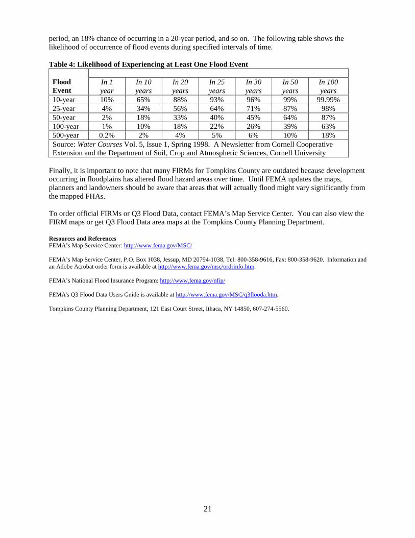
period, an 18% chance of occurring in a 20-year period, and so on. The following table shows the likelihood of occurrence of flood events during specified intervals of time. Table 4: Likelihood of Experiencing at Least One Flood Event
Flood Event
In 1 year
In 10 years
In 20 years
In 25 years
In 30 years
In 50 years
In 100 years
10-year 10% 65% 88% 93% 96% 99% 99.99% 25-year 4% 34% 56% 64% 71% 87% 98% 50-year 2% 18% 33% 40% 45% 64% 87% 100-year 1% 10% 18% 22% 26% 39% 63% 500-year 0.2% 2% 4% 5% 6% 10% 18% Source: Water Courses Vol. 5, Issue 1, Spring 1998. A Newsletter from Cornell Cooperative Extension and the Department of Soil, Crop and Atmospheric Sciences, Cornell University
Finally, it is important to note that many FIRMs for Tompkins County are outdated because development occurring in floodplains has altered flood hazard areas over time. Until FEMA updates the maps, planners and landowners should be aware that areas that will actually flood might vary significantly from the mapped FHAs. To order official FIRMs or Q3 Flood Data, contact FEMA’s Map Service Center. You can also view the FIRM maps or get Q3 Flood Data area maps at the Tompkins County Planning Department. Resources and References FEMA’s Map Service Center: http://www.fema.gov/MSC/ FEMA’s Map Service Center, P.O. Box 1038, Jessup, MD 20794-1038, Tel: 800-358-9616, Fax: 800-358-9620. Information and an Adobe Acrobat order form is available at http://www.fema.gov/msc/ordrinfo.htm. FEMA’s National Flood Insurance Program: http://www.fema.gov/nfip/ FEMA's Q3 Flood Data Users Guide is available at http://www.fema.gov/MSC/q3flooda.htm. Tompkins County Planning Department, 121 East Court Street, Ithaca, NY 14850, 607-274-5560.
21
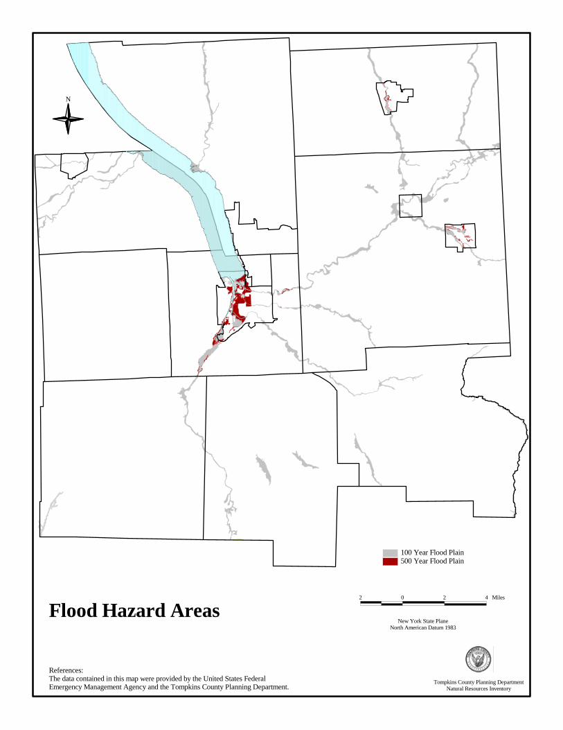
N
Flood Hazard Areas
References:The data contained in this map were provided by the United States Federal Emergency Management Agency and the Tompkins County Planning Department.
100 Year Flood Plain500 Year Flood Plain
New York State PlaneNorth American Datum 1983
2 0 2 4 Miles
Tompkins County Planning DepartmentNatural Resources Inventory

SLOPE AND TOPOGRAPHY What are Slope and Topography? Slope and topography describe the shape and relief of the land. Topography is a measurement of elevation, and slope is the percent change in that elevation over a certain distance. Topography may be measured with lines that connect points representing the same elevation; these are called topographic contours. Slope is measured by calculating the difference in the elevation from one point to another divided by the lateral distance between those points. Why are Slope and Topography Important? Topography and slope should be considered when drawing up site plans for any construction project. Consideration of the slope of the land is important to reduce construction costs, minimize risks from natural hazards such as flooding and landslides, and to minimize the impacts of proposed development on natural resources such as soils, vegetation, and water systems. Topographic data can also be used to create a model of the land’s surface called a digital elevation model (DEM). A hill-shade relief map created from a DEM is depicted on the cover of this Natural Resources Inventory. Slope and Topography in Tompkins County Tompkins County is characterized by diverse topography. The northern regions of the County consist of medium to high elevation areas that are fairly flat. The flatness of these areas makes them ideal for farming. Segments of creeks in this area flow through gorges which have extremely steep slopes. Many of the more urbanized areas of the County are in the lowland areas, including most of the City of Ithaca, which lies in the flat floodplain at the southern end of Cayuga Lake. Although that area is ideal for development due to its flat terrain, areas of the City have become increasingly flood-prone as the watershed becomes more developed. While storm sewers help divert the increased flow of water from the impervious surfaces to Cayuga Lake, flooding downslope is still a problem. The Villages of Trumansburg, Groton, Freeville, and Dryden are also located in flat floodplains adjacent to creeks that are often subjected to flooding. The southern portion of the County has the highest elevations and the most relief. The highest point in Tompkins County is the top of Connecticut Hill at 2200 feet. There are several hills in the towns of Newfield, Danby, and Caroline that have elevations in the 1600-1880 foot range. Maps and Data Historically, the U.S. Geological Survey (USGS) has been the purveyor of topographic maps for the County. The 7.5 minute, 1:24,000 scale quadrangle series is the most commonly used topographic map. These paper maps can be purchased at many bookstores and outfitters, as well as directly from USGS, or they may be downloaded as digital files from the USGS’s website. Digital GIS data sets of the topographic contours may also be obtained from the USGS. Tompkins County has a digital data set of 20-foot contour intervals for the entire County. For some towns, 10-foot contours are available. For a map of this information, in paper or digital format, contact the Tompkins County Planning Department. Resources/References Tompkins County Planning Department, 121 East Court Street, Ithaca, NY 14850, 607-274-5560. New York State Geological Survey: http://www.nysm.nysed.gov/gis.html United States Geological Survey, 30 Brown Road, Ithaca, NY 14850, 607-266-0217 http://mapping.usgs.gov
23
SOILS What are Soils? Soil is a mixture of mineral particles, organic matter, water, and air. Soils are usually described in terms of their texture, e.g., sand, silt, and clay. Why are Soils Important? Soils affect a variety of human activities from agriculture to the engineering and construction of roads, buildings, and sewage disposal systems. They are critical in determining the productivity and viability of agricultural operations. The United States Department of Agriculture (USDA) Natural Resources Conservation Service (NRCS) evaluates soils in terms of their capability to support agriculture. These range from Class I soils, which are productive and easy to work, to Class VIII soils, which are not suitable for growing crops, pasture, or trees for profit. Planning boards, elected officials, zoning officers, developers, etc., can use soil maps to identify areas suitable for future development of homes, industry, agriculture, and recreation. For example, a soil map may indicate poorly drained areas, which should not be used for residential development because of the need for costly drainage facilities. Soil maps can also be used to assess the likelihood of finding suitable sites for individual, on-site, sewage disposal systems. Classification of Soils NRCS (and its predecessor, the Soil Conservation Service) was the agency responsible for preparation of maps showing soil series containing soils that share common profiles. Soil series are further divided into soil types that share common physical features, general properties that affect the use of the soil, and properties that limit suitability for cultivation. In addition to being evaluated in terms of agricultural viability, soil types have been assessed by the NRCS in terms of their suitability for various types of development. Soil characteristics that are considered in this assessment are depth to seasonal high water table, depth to bedrock, flood potential, and permeability. Depth to seasonal high water table affects both building foundation and septic system siting. A seasonal high water table can cause flooding in basements or cause a septic system to malfunction. A high water table can also affect the ability of a soil to support weighty structures. Maps and Data Soils are mapped at various levels of detail, the two most common being general soil maps and soil surveys. General soil maps show soil associations that share a characteristic landscape and pattern of soils. The soils within any one association may be somewhat similar, but they commonly differ in many important characteristics. These maps are suitable for planning large areas such as multi-county regions and large drainage basins. A General Soil Map is published in the Soil Survey: Tompkins County, New York at a scale of 1:126,720 (or 1 inch = 2 miles). This map divides Tompkins County into ten soil associations. Soil survey maps are more detailed. The area of soil delineated on these maps can be as small as one or two acres. These maps can be used for planning at the county or municipal level. The Soil Survey: Tompkins County, New York was published in 1965 by the Soil Conservation Service and includes detailed maps (at a scale of 1:20,000) overlaid on aerial photographs. It was one of the first soil surveys published in New York State. The Soil Survey also includes descriptions of the soil types and tables showing the characteristics of the soils. Soon after it was published, the Soil Conservation Service revamped the soil categories for New York State. They are expecting to update the old 1965 data, compiled for Tompkins County and some surrounding counties, within the next decade and release it in digital format.
26
In the meantime, the Tompkins County GIS Program has digitized and rectified the 1965 Soil Survey maps so that they may be used digitally until the new soil survey is published. The map on the following page is a section of one of the soil survey maps from the Soil Survey: Tompkins County, New York. For a map of soil information, in paper or digital format, contact the Tompkins County Planning Department or the Tompkins County Soil and Water Conservation District. Information from, or copies of, the Soil Survey: Tompkins County, New York (published in 1965) can be obtained from the Tompkins County Soil and Water Conservation District. Resources/References Tompkins County Planning Department, 121 East Court Street, Ithaca, NY 14850, 607-274-5560. Tompkins County GIS Program, Information Technical Services, 128 East Buffalo Street, Ithaca, NY 14850, 607-274-5418. http://www.tompkins-co.org/gis Tompkins County Soil and Water Conservation District, 903 Hanshaw Rd, Ithaca, NY 14850, 607-257-2340. United States Department of Agriculture, Soil Conservation Service – in cooperation with the Cornell University Agricultural Experiment Station. Soil Survey: Tompkins County, New York. U.S. Government Printing Office, Washington, DC. 1965.
27

Tompkins County Planning DepartmentNatural Resources Inventory
References:The data contained in this map were provided by the USDA Soil Conservation Service Soils Survey and the Tompkins County Planning Department.
New York State PlaneNorth American Datum 1983
2 0 2 4 Miles
Sample of Soil Survey Map
BEDROCK GEOLOGY What is Bedrock Geology? Bedrock geology describes the basic rock formations that underlie soils and unconsolidated materials (see Surficial Geology section). Bedrock occasionally protrudes through these materials or may be exposed alongside roads and creek beds. These rocks, formed millions of years ago, constitute the foundation of materials and topography in a region. Bedrock is found beneath the soils and may, in Tompkins County, be buried beneath glacial till, composed of rock fragments of various sizes that were released from glaciers as they receded. Why is Bedrock Geology Important? In Tompkins County, the depth to bedrock is relatively shallow, sometimes only 5 to 10 feet below the surface of the soil. Shallow depth to bedrock significantly impacts the location, development, maintenance, and cost of public services, such as sewers, water supply systems, and roads. Construction feasibility and costs for private investments, such as building foundations, septic tanks, and private roads, are partially dependent on the depth to bedrock. Shallow bedrock may also be subject to frost heaving and deformation. Determination of bedrock qualities must be made on a site-specific basis. How was Bedrock Formed? Approximately 550 million years ago, the land that is now Tompkins County and the surrounding region was submerged under an ancient sea. Over the course of 325 million years, layers of sediment (sand, mud, salt, and lime) were deposited on the lake bottom and slowly hardened into beds of sedimentary rocks that we now know as sandstone, shale, and limestone. Bedrock Geology in Tompkins County There are four major groupings of bedrock in Tompkins County. The formations found within a group are shown in parentheses. The following are listed from oldest to youngest formations: 1. Hamilton Group (Dhmo, Dhld) – These blackish to bluish-gray shales and thin beds of limestone
are found at elevations of 600 to 1500 feet in the Moscow formation (Dhmo) which runs along both sides of Cayuga Lake, as well as the Ludlowville formation (Dhld) which juts out into the lake below the Moscow formation near Salmon Creek. These bedrock formations can be seen along East Shore Drive from Ithaca to Ludlowville. The tall bedrock cliffs that are visible along the east side of the lake are the Moscow formation.
2. Genesee Group (Dg, Dt) – This grouping of limestone, shale, and siltstone is the bedrock visible in
the gorges surrounding the City of Ithaca at elevations of 400 to 1000 ft. The Ithaca Formation (Dg) comprises most of the northern section of the County, with greater representation in the northeast, and is the most predominant bedrock formation in the County. Tully Limestone (Dt) is located near Cayuga Lake.
3. Sonyea Group (Ds) – These siltstones and shales can be found between 200 and 1,000 feet in
elevation. 4. West Falls Group (Dwm, Dwrg - Gardeau Formation) – These shales and siltstones are found at
elevations between 1,100 and 1,600 feet and are located in the southern portion of Tompkins County. Maps and Data The New York State Geological Survey has produced a geographic data set of bedrock geology. The Bedrock Geology map was created at a scale of 1:250,000, and depicts general locations of various rock formations; it should not be used for any site-specific analyses.
29

For a map of this information, in paper or digital format, contact the Tompkins County Planning Department or U.S. Geological Survey. For more detail on New York State Bedrock formations, go to the following website: http://www.nysm.nysed.gov/data/bedrock.txt Resources/References Tompkins County Planning Department, 121 East Court Street, Ithaca, NY 14850, 607-274-5560. New York State Geological Survey: http://www.nysm.nysed.gov/gis.html United States Geological Survey: http://www.usgs.gov/pubprod/index.html Von Englen, O.D. The Fingerlakes Region: Its Origin and Nature. 1961. Ithaca, NY: Cornell University Press.
30
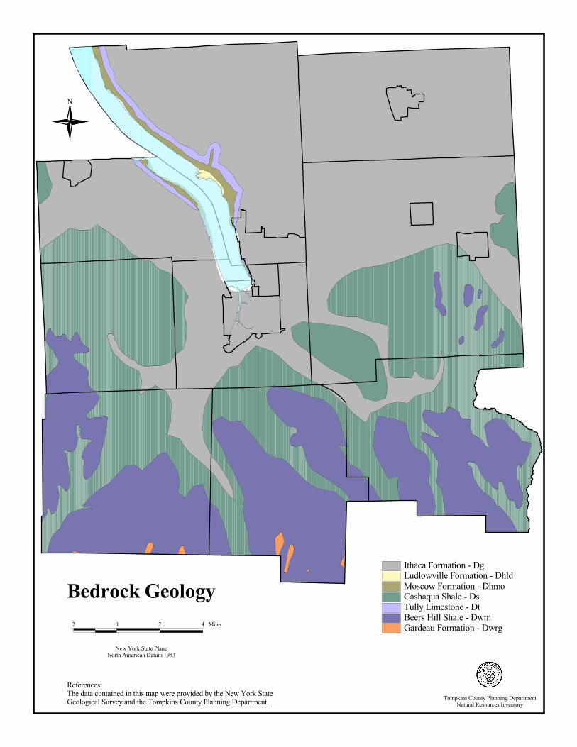
References:The data contained in this map were provided by the New York State Geological Survey and the Tompkins County Planning Department.
N
New York State PlaneNorth American Datum 1983
2 0 2 4 Miles
Bedrock GeologyIthaca Formation - DgLudlowville Formation - DhldMoscow Formation - DhmoCashaqua Shale - DsTully Limestone - DtBeers Hill Shale - DwmGardeau Formation - Dwrg
Tompkins County Planning DepartmentNatural Resources Inventory
SURFICIAL GEOLOGY What is Surficial Geology? Surficial geology describes the rocks and unconsolidated materials that lie between bedrock and the surface of the land. While “soils” refers to the organic components in these materials, “surficial geology” refers to the rock and mineral components of these materials. Glaciers receding 12,000 to 25,000 years ago deposited these materials. When the glaciers receded, the rock and debris frozen within the ice were left behind in various formations depending upon how fast or slow the glacier receded. These formations contain various sized particles and are classified by the shape of formation, the thickness, and the type and size of particles found. Why is Surficial Geology Important? Surficial geology is important because the characteristics of materials below the earth’s surface influence the feasibility of constructing buildings and roads. Surficial deposits commonly determine soil composition and therefore may affect agricultural viability. Surficial Geology Deposits in Tompkins County There are eight types of surficial geology deposits in Tompkins County: 1. Recent Alluvium consists of recent deposits that range from fine sands to gravels and are generally
confined to floodplains within a valley. They may be subject to frequent flooding and, in larger valleys, may be overlain by silt. Deposits range from 3 to 30 feet in thickness.
2. Lacustrine Sands are well sorted (particles are of similar size) and stratified sand deposits that
settled out when lakes were formed by the melting glaciers. Deposits found today range from 6 to 60 feet in thickness.
3. Lacustrine Silts are generally laminated silt and clay, deposited in lakes formed during the melting
of the glaciers. They are high in calcite, have low permeability, and form potentially unstable land. These are found in variable thickness of up to 160 feet.
4. Outwash Sand and Gravel is coarse to fine gravel mixed with sand. Location is restricted to valley
bottoms and stream terrace. These deposits are of variable thickness of five to 65 feet. 5. Kames are glacial deposits of various forms which are called kames, eskers, kame terraces, and kame
deltas. They are small, irregular hills and terraces deposited by glaciers and are typically found in valleys. These deposits are composed of coarse to fine gravels and/or sands in thicknesses of 30 to 100 feet.
6. Kame Moraines are glacial deposits of various sizes from boulders to sand deposited at an active ice
margin during glacial retreat. Locally they may be laden with calcareous cement. These are found in thicknesses of 30 to 100 feet.
7. Till deposits are poorly sorted (particles of varying sizes) material of variable texture such as clay,
silt-clay, or boulder clay that were deposited beneath the glacial ice. Permeability of these deposits varies with the amount of compaction. Thicknesses vary from 3 to 160 feet.
8. Till Moraine is much like till, but has a more variable sorting, and is generally more permeable than
till. Deposits of till moraine were typically set down adjacent to glacial ice. Thicknesses vary from 30 to 100 feet.
32

Maps and Data The New York State Geological Survey’s Surficial Geology map was created at a scale of 1:250,000. For this reason, it should not be used for site specific analysis, but should only be used for general planning purposes. For a map of this information, in paper or digital format, contact the Tompkins County Planning Department or USGS. Resources and References Tompkins County Planning Department, 121 East Court Street, Ithaca, NY 14850, 607-274-5560. New York State Geological Survey: http://www.nysm.nysed.gov/gis.html U.S. Geological Survey (USGS), 30 Brown Road, Ithaca, New York 14850, 607-266-0217.
33

Surficial Geology2 0 2 4 Miles
New York State PlaneNorth American Datum 1983
N
References:The data contained in this map were provided by the New York State Geological Survey and the Tompkins County Planning Department.
Recent DepositsWaterKame DepositsKame MoraineLacustrine SandLacustrine Silt & ClayOutwash Sand & GravelBedrockTillTill Moraine
Tompkins County Planning DepartmentNatural Resources Inventory

UNIQUE NATURAL AREAS
What is a Unique Natural Area? The Unique Natural Areas (UNAs) of Tompkins County are sites with outstanding environmental qualities, as defined by the Tompkins County Environmental Management Council, that are deserving of special attention for preservation and protection. UNAs include such natural features as gorges, woods, swamps, fens, cliffs, and streams. They lie on both publicly and privately owned lands and are generally not open to the public. Anyone wishing to visit a site on private land must obtain permission from the owner or owners. Why are Unique Natural Areas Important? Unique Natural Areas are recognized because of the outstanding qualities that render them “unique” within Tompkins County. Often, the characteristics that make a site unique are extremely vulnerable to a wide range of both direct and indirect impacts and may be compromised by disturbing the site. For this reason, the UNA Inventory incorporates an array of data that can be utilized in planning efforts to help identify and mitigate potential impacts to a UNA. What are the Criteria for a Unique Natural Area? At least one of five criteria must be met to classify an area as a UNA: 1. Important Natural Community: the site includes a state-designated wetland, a designated natural
area/preserve, historical botanical/zoological characteristics, important teaching characteristics, an old-growth forest, a plant or animal community type that is rare or scarce in the County, diverse flora or fauna, a birding site, and/or a wilderness character.
2. Quality of Example: the site is considered the best representative, or example, of an ecosystem, plant
community, or animal community of high quality within the County. These sites typically contain especially large individuals, dense populations, and/or a particularly diverse mixture of species.
3. Rare or Scarce Plants or Animals: the site contains plant or animal species that have been
recognized as rare or scarce at a national, state, or local level; has critical migration, reproductive, or feeding habitat for rare or scarce animal species; and/or has reports of large mammals.
4. Geological Importance: the site includes a rare or outstanding example of geological features or
processes and/or a paleontological site. 5. Aesthetic/Cultural Qualities: the site contains acknowledged outstanding natural or scenic beauty as
viewed from within or from a distance, has recreational value, is designated as urban greenspace, and/or has cultural/historic/archeological significance.
35
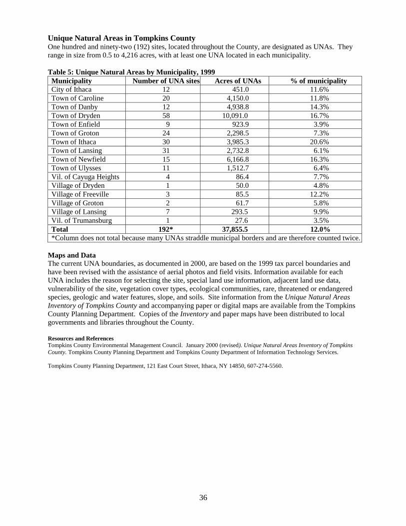
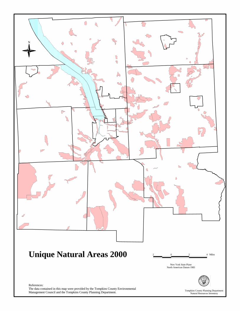
Unique Natural Areas in Tompkins County One hundred and ninety-two (192) sites, located throughout the County, are designated as UNAs. They range in size from 0.5 to 4,216 acres, with at least one UNA located in each municipality. Table 5: Unique Natural Areas by Municipality, 1999 Municipality Number of UNA sites Acres of UNAs % of municipality City of Ithaca 12 451.0 11.6% Town of Caroline 20 4,150.0 11.8% Town of Danby 12 4,938.8 14.3% Town of Dryden 58 10,091.0 16.7% Town of Enfield 9 923.9 3.9% Town of Groton 24 2,298.5 7.3% Town of Ithaca 30 3,985.3 20.6% Town of Lansing 31 2,732.8 6.1% Town of Newfield 15 6,166.8 16.3% Town of Ulysses 11 1,512.7 6.4% Vil. of Cayuga Heights 4 86.4 7.7% Village of Dryden 1 50.0 4.8% Village of Freeville 3 85.5 12.2% Village of Groton 2 61.7 5.8% Village of Lansing 7 293.5 9.9% Vil. of Trumansburg 1 27.6 3.5% Total 192* 37,855.5 12.0% *Column does not total because many UNAs straddle municipal borders and are therefore counted twice.
Maps and Data The current UNA boundaries, as documented in 2000, are based on the 1999 tax parcel boundaries and have been revised with the assistance of aerial photos and field visits. Information available for each UNA includes the reason for selecting the site, special land use information, adjacent land use data, vulnerability of the site, vegetation cover types, ecological communities, rare, threatened or endangered species, geologic and water features, slope, and soils. Site information from the Unique Natural Areas Inventory of Tompkins County and accompanying paper or digital maps are available from the Tompkins County Planning Department. Copies of the Inventory and paper maps have been distributed to local governments and libraries throughout the County. Resources and References Tompkins County Environmental Management Council. January 2000 (revised). Unique Natural Areas Inventory of Tompkins County. Tompkins County Planning Department and Tompkins County Department of Information Technology Services. Tompkins County Planning Department, 121 East Court Street, Ithaca, NY 14850, 607-274-5560.
36
References:The data contained in this map were provided by the Tompkins County Environmental Management Council and the Tompkins County Planning Department.
N
Unique Natural Areas 2000New York State Plane
North American Datum 1983
2 0 2 4 Miles
Tompkins County Planning DepartmentNatural Resources Inventory

NEW YORK STATE PARKS, FORESTS AND WILDLIFE MANAGEMENT AREAS
What are New York State Parks? State Parks are tracts of land owned and maintained by the State of New York. Because they are owned by the State, all citizens have access to the lands. State Parks are managed by the New York State Office of Parks, Recreation, and Historic Preservation, primarily for recreation and tourism. In general, these lands usually contain outstanding natural or historic resources. Permitted uses, such as hunting, fishing, biking, camping, ATV, and snowmobile and horseback riding, vary from park to park. New York State Parks in Tompkins County There are four State Parks located in Tompkins County: Robert H. Treman, Taughannock Falls, Buttermilk Falls, and Allan H. Treman State Marine Park. Robert H. Treman (Enfield Glen), Taughannock Falls, and Buttermilk Falls all have dramatic gorges, swimming, camping, hiking, and picnicking facilities. Jennings Pond, part of Buttermilk Falls State Park, is geographically disconnected from the Park’s gorge, and contains a large pond with swimming and picnic facilities. Allan H. Treman State Marine Park is located on Cayuga Lake and has a 400-slip marina and boat launch. Taughannock Falls State Park also has a marina and boat launch. Although not designated as a State Park, there is also some significant undeveloped state-owned land, known locally as Salt Point, which is located at the outflow of Salmon Creek on Cayuga Lake, next to the Lansing Town Park and Marina at Myers Point. What are New York State Forests? State Forests are tracts of land owned and maintained by the State of New York. Because they are owned by the State, all citizens have access to the lands. State Forests are managed by the New York State Department of Environmental Conservation (DEC), Division of Forests and Lands. They are managed for forestry, water quality, wildlife protection, and recreation. Permitted uses, such as hunting, fishing, biking, camping, ATV, and snowmobile and horseback riding, vary from forest to forest. New York State Forests in Tompkins County There are eight State Forests in Tompkins County (encompassing approximately 32,000 acres), concentrated in the southern portion of the County: Hammond Hill, Robinson Hollow, Cliffside, Newfield, Danby, Shindagin Hollow, Potato Hill, and Yellow Barn. The DEC Region 7 Recreational Master Plan, to be released in August 2001, will outline a plan to develop trails designed specifically for mountain biking, hiking, horseback riding, snowmobile, and ATV use. As part of this effort, the DEC will develop maps and trail markers to assist those visiting the forests. This initiative will take several years to complete. What are New York State Wildlife Management Areas? State Wildlife Management Areas (WMAs) are tracts of land owned and maintained by the State of New York. Because they are owned by the State, all citizens have access to the lands. WMAs are managed by the New York State Department of Environmental Conservation (DEC), Division of Fish and Wildlife. They are managed for certain species or groups of species. Permitted uses, such as hunting, fishing, biking, camping, ATV, and snowmobile and horseback riding, vary from area to area. New York State Wildlife Management Areas in Tompkins County Tompkins County has two WMAs: Dryden Lake (207 acres) and Connecticut Hill (11,045 acres). Why are These State Lands Important? State Parks, Forests, and Wildlife Management Areas protect important lands from development and uses that may damage their natural features. These State lands provide recreational and cultural opportunities, protect key plant and animal species and their habitats, and protect watersheds and the quality of water in the area. They also add economic value to their surrounding areas by enhancing tourism and increasing land values. In addition, they provide important educational opportunities for teaching about botany,
38
natural history, entomology, etc. Although municipal governments do not have direct control of these lands, they may be able to use them in their planning efforts to create greenways, biological corridors, and recreational trails. New York State WMAs and Forests are also utilized for logging. Logging in State Forests are monitored by the DEC to ensure that trees of varying sizes and ages are left for future generations. The focus of logging activities in WMAs is to manage habitat and provide a diversity of vegetation types and wildlife species. Maps and Data For map information, in paper or digital format, contact the Tompkins County Planning Department. For management plans and further information about New York State Forests and WMAs, contact the New York State DEC. For information on New York State Parks, contact the New York State Office of Parks, Recreation, and Historic Preservation. Resources and References New York State Department of Environmental Conservation (DEC), Region 7, 1285 Fisher Avenue, Cortland, NY 13045-1090, 607-753-3095. New York State Department of Parks, Recreation and Historic Preservation, Finger Lakes State Park Region, PO Box 1055, 2221Taughannock Park Road, Trumansburg, New York 14886, 607-387-7041. http://nysparks.state.ny.us/ New York State Forests and Wildlife Management Areas: http://www.dec.state.ny.us/ New York State Marine Park: http://www.cce.cornell.edu/seagrant/marinas/bcmarinas.html Tompkins County Planning Department, 121 East Court Street, Ithaca, NY 14850, 607-274-5560.
39
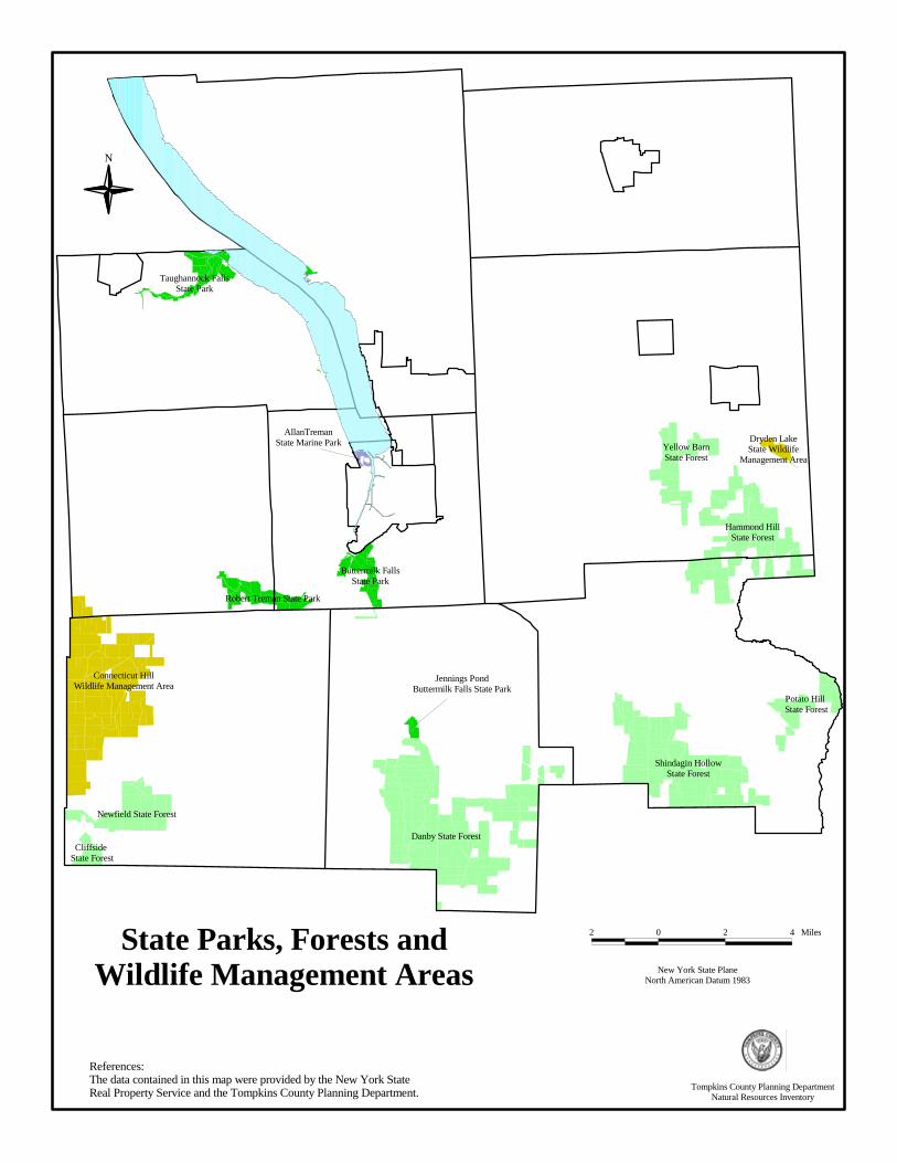
References:The data contained in this map were provided by the New York State Real Property Service and the Tompkins County Planning Department.
N
New York State PlaneNorth American Datum 1983
2 0 2 4 MilesState Parks, Forests andWildlife Management Areas
Taughannock FallsState Park
Robert Treman State Park
Buttermilk FallsState Park
AllanTremanState Marine Park
Hammond HillState Forest
Yellow BarnState Forest
Shindagin HollowState Forest
Danby State Forest
Connecticut HillWildlife Management Area
Potato Hill State Forest
Newfield State Forest
Dryden LakeState Wildlife
Management Area
Cliffside State Forest
Jennings PondButtermilk Falls State Park
Tompkins County Planning DepartmentNatural Resources Inventory
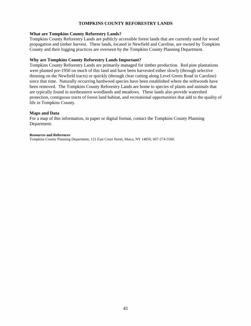
TOMPKINS COUNTY REFORESTRY LANDS What are Tompkins County Reforestry Lands? Tompkins County Reforestry Lands are publicly accessible forest lands that are currently used for wood propagation and timber harvest. These lands, located in Newfield and Caroline, are owned by Tompkins County and their logging practices are overseen by the Tompkins County Planning Department. Why are Tompkins County Reforestry Lands Important? Tompkins County Reforestry Lands are primarily managed for timber production. Red pine plantations were planted pre-1950 on much of this land and have been harvested either slowly (through selective thinning on the Newfield tracts) or quickly (through clear cutting along Level Green Road in Caroline) since that time. Naturally occurring hardwood species have been established where the softwoods have been removed. The Tompkins County Reforestry Lands are home to species of plants and animals that are typically found in northeastern woodlands and meadows. These lands also provide watershed protection, contiguous tracts of forest land habitat, and recreational opportunities that add to the quality of life in Tompkins County. Maps and Data For a map of this information, in paper or digital format, contact the Tompkins County Planning Department. Resources and References Tompkins County Planning Department, 121 East Court Street, Ithaca, NY 14850, 607-274-5560.
41
Tompkins County Reforestry Lands
N
References:The data contained in this map were provided by the Tompkins County Assessment Department and the Tompkins County Planning Department.
Tompkins County Planning DepartmentNatural Resources Inventory
New York State PlaneNorth American Datum 1983
2 0 2 4 Miles
IMPORTANT BIRD AREAS What are Important Bird Areas? The National Audubon Society, with the support of the American Bird Conservancy, initiated the New York Important Bird Areas (IBAs) Program in the spring of 1996. Designation of an area as a significant bird habitat under the IBA Program requires that the site satisfy at least one of the following criteria: �� Site contains a concentration of birds in significant numbers when breeding, in winter, or during
migration; �� Site supports a population of a species that is endangered, threatened, or of special concern; �� Site contains assemblages of species characteristic of a representative rare, threatened, or unique
habitat; or �� Long-term avian research or monitoring occurs on the site Across New York State, 127 IBAs have been identified. Furthermore, in 1997, New York State passed a law allowing IBAs located on state land to be designated as Bird Conservation Areas. Why are Important Bird Areas Important? The IBA Program is important for avian conservation because it identifies significant bird habitats so that others may protect those lands. Many avian species have distinct life history requirements and/or habitat needs that are fulfilled by the qualities of IBAs. The IBA program informs local citizens and governments about these unique areas and encourages local voluntary conservation efforts. Important Bird Areas in Tompkins County In Tompkins County, four IBAs have been identified: 1. Cayuga Lake supports a very diverse bird community, providing important bird habitat to migrating
and wintering waterfowl (at least 37 species of ducks and geese) and rare and endangered species. Of state protected bird species, two endangered (Bald Eagle and Black Tern), two threatened (Pied-billed Grebe and Common Tern), and two of special concern (Common Loon and Osprey) are known to use Cayuga Lake for either wintering or migratory habitat.
2. The Caswell Road Grassland Complex (1343 acres) is a privately owned hunting club in the Town
of Dryden. The abandoned farmland serves as a breeding site for three threatened species (Northern Harrier, Upland Sandpiper, and Henslow’s Sparrow), a species of special concern (Grasshopper Sparrow), and two more common species (Savannah Sparrow and Bobolink). The hunting club currently manages the property for Wild Turkey, Ring-necked Pheasant, and White-tailed Deer, which does not seem to interfere with the grassland birds.
3. The Salmon Creek IBA (500 acres) encompasses a one-mile long stretch on both sides of Salmon
Creek in the Town of Lansing. The area is heavily wooded with a dense understory. Home to a number of songbirds, the site is important breeding habitat for Cerulean Warblers (46 pairs in 1997), which is a state listed species of special concern. Within this IBA, land ownership is fragmented. The Finger Lakes Land Trust has purchased 3 parcels totalling 33 acres and hopes to work with other riparian landowners on future conservation efforts.
4. The Connecticut Hill Wildlife Management Area (WMA) (11,045 acres) is a state-owned forest in
the Town of Newfield managed by the New York State Department of Environmental Conservation primarily for conservation, recreation, and forestry. The site is home to a breeding community of Ruffed Grouse, Wild Turkey, Northern Goshawk, Hermit Thrush, Red-breasted Nuthatch, Acadian Flycatcher, Louisiana Waterthrush, and a variety of warblers. Three species of State special concern breed in this WMA: Sharp-shinned Hawk, Cooper’s Hawk, and Northern Goshawk.
43

Maps and Data The boundaries of the IBAs are not published. In order to protect landowner privacy, the National Audubon Society of New York State does not release paper maps of the IBAs and no digital files exist at this time. The general locations of the sites are depicted in point data. The shores of Cayuga Lake were used to identify the Cayuga Lake IBA and the boundary of the Connecticut Hill Wildlife Management Area was used to identify that IBA. The private landowners of the Caswell Road and Salmon Creek IBAs have requested that Audubon not publish those locations at this time. The New York IBA program recently received a grant to map the IBAs on a geographical information system. Digitizing of the information is scheduled to be completed by the end of 2002. Resources and References National Audubon Society of New York State, 200 Trillium Lane, Albany, NY 12203, 518-869-9731. Email: [email protected]. Webpage: http://ny.audubon.org.
A book entitled Important Bird Areas in New York State is available from the National Audubon Society of New York State.
44
NATURAL HERITAGE SITES What is a Natural Heritage Site? A Natural Heritage Site is a point or area representing specific natural resource information documented by the New York Natural Heritage Program. The goal of this program, a joint venture of the New York State Department of Environmental Conservation (DEC) and The Nature Conservancy (TNC) since 1985, is to compile and maintain an up-to-date inventory of the location and status of New York State’s rarest animal and plant species and its ecological communities. The Natural Heritage Program monitors the status of 755 rare plant species, 417 rare animal species, and 165 ecological community types in New York State. Why are Natural Heritage Sites Important? The databases maintained by the New York Natural Heritage Program can assist in identifying threatened or endangered species and ecological communities in Tompkins County. This knowledge can be incorporated into planning, conservation, and natural resources management to help conserve the plants, animals, and ecological communities that represent the County’s natural heritage. Though not a requirement of the State Environmental Quality Review Act (SEQRA), the Natural Heritage Program will search its databases upon request for proposed actions subject to SEQRA review. Natural Heritage Sites in Tompkins County Currently, the Natural Heritage Program databases list 14 rare plant species, 3 rare animal species, and 9 significant ecological community types in Tompkins County. Maps and Data Information on the status and distribution of rare and endangered animals and plants, and the best examples of New York State’s ecological communities, is collected, stored, and analyzed in databases maintained by the Natural Heritage Program. This information has been assembled from historical records and collections maintained by scientific institutions such as the New York State Museum, and from field surveys by staff from the New York Natural Heritage Program and other scientific groups. Neither site-specific nor comprehensive surveys for rare species and significant natural communities have been conducted for the entire state. Therefore, these data cannot be relied on as a definitive statement of the presence or absence of rare species or significant ecological communities, and cannot be substituted for on-site surveys that may be required for environmental assessment. The Tompkins County Planning Department is authorized to make paper maps of this data only at a scale equal to or greater than 1:100,000. No data may be released by TCPD digitally. For a paper map of this information, contact the Tompkins County Planning Department. For information concerning the data, or to request site specific information, contact the New York Natural Heritage Program. Resources and References NYS DEC, Division of Fish, Wildlife, and Marine Resources http://www.dec.state.ny.us/website/dfwmr/index.html
New York Natural Heritage Program: Overview. February 2001. New York State DEC and The Nature Conservancy. New York State DEC: Endangered Species http://www.dec.state.ny.us/website/dfwmr/wildlife/endspec/index.html NYS Natural Heritage Program Information Services, NYS DEC, 625 Broadway, Albany, NY 12233-4757, 518-402-8935. http://www.nynhp.org
45
CRITICAL ENVIRONMENTAL AREAS, NATIONAL NATURAL LANDMARKS, AND NEW
YORK STATE RECREATIONAL RIVERS CRITICAL ENVIRONMENTAL AREAS What are Critical Environmental Areas? Under New York State Environmental Quality Review Act (SEQRA) Regulations, local agencies may designate, via local legislation, specific geographic areas within their boundaries as Critical Environmental Areas (CEAs). State agencies may also designate CEAs on state owned, managed, or regulated lands. For final approval, all CEAs must be mapped and announced through public notice and a public hearing. Why are Critical Environmental Areas Important? The designation of a Critical Environmental Area provides some regulatory protection for a site and functions as an indicator to developers, local officials, and other governmental agencies that the site is of significant environmental value. Critical Environmental Areas in Tompkins County Coy Glen, located in the Town of Ithaca, is the only CEA in Tompkins County. Coy Glen is an important botanic and geologic site, and is home to uncommon ecological communities and rare species. Many rare species reside in the hilltop forests of Coy Glen and the gorge walls provide habitat for scarce liverworts, mosses, and ferns. NATIONAL NATURAL LANDMARKS What are National Natural Landmarks? A National Natural Landmark is a nationally significant natural area that has been designated by the U.S. Secretary of the Interior. To be nationally significant, a site must be one of the best examples of a type of biotic community or geologic feature in its physiographic province. To date, 587 sites throughout the United States have been designated as National Natural Landmarks. Why are National Natural Landmarks Important? As required by the National Environmental Policy Act, federal agencies must consider National Natural Landmarks when assessing the impacts of their actions on the environment. Also, under SEQRA, applicants must state if the proposed project is contiguous to a site listed on the Register of National Natural Landmarks. All National Natural Landmarks are field checked every five years for evidence of significant change using the National Park Service’s National Natural Landmark national significance criteria. The goal of the NNL program is to identify, recognize, and encourage the protection of sites containing the best remaining examples of ecological and geological components of the nation’s landscape. National Natural Landmarks in Tompkins County McLean Bogs, located in the Town of Dryden, is the only designated National Natural Landmark in Tompkins County. McLean Bogs is recognized as an important glacial landform and contains significant deciduous forests, lakes, and ponds. The characteristics that make this site unique are extremely vulnerable to a wide range of both direct and indirect impacts and may be compromised by disturbing the site. Anyone wishing to visit McLean Bogs must obtain permission from Cornell University (Cornell Plantations), which owns and manages the National Natural Landmark. NEW YORK STATE RECREATIONAL RIVERS What are New York State Recreational Rivers? New York State Recreational Rivers are unique water bodies that are designated for protection by state legislative action. Proposals for designation can come from local governments, agencies, or citizen groups, but must be submitted to the New York State Department of Environmental Conservation (DEC), the governor, and the New York State legislature for approval or modification. The DEC is also
46
responsible for issuing permits within the boundaries of designated rivers, though they are able to delegate the administration of the river to local governments. Why are New York State Recreational Rivers Important? Recreational Rivers in New York State are protected by Article 15, Title 27 of the Environmental Conservation Law, entitled the New York State Wild, Scenic, and Recreational River System Act. Its purpose is to preserve and protect designated water bodies (including rivers, streams, creeks, runs, kills, rills, branches, and lakes) and their immediate environs for present and future generations. New York State Recreational Rivers in Tompkins County In 1990, the State of New York designated a stretch of Fall Creek a Recreational River at the request of the City of Ithaca. Running from the west face of the footbridge between Thurston Avenue and Beebe Lake to its confluence with Cayuga Lake, it is the only water body in Tompkins County with this designation. The DEC delegated administration of the Fall Creek Recreational River to the City of Ithaca Planning Department. The designation of Fall Creek as a Recreational River mandates the preservation and restoration of its natural, scenic, and recreational qualities. Prohibited uses include: 1) modification of the waterway by impoundment, diversion, rip-rap, bulkheads, structures, or improvements impeding or altering the natural flow of water or free-flowing condition of the river, 2) private dwellings, mobile homes, and multiple family dwellings located within the 100 year flood plain or within 150 feet of the river and/or tributary bank, 3) forest management roads or tributary bridges within 150 feet, and 4) waste treatment, storage, or disposal, except in temporary storage containers. Permits are required for other land uses and development within the Recreational River boundary, such as residential dwellings, docks, and private water supply wells. Maps and Data Generalized boundary data for Coy Glen, McLean Bogs, and Fall Creek are available in both digital and paper format from the Tompkins County Planning Department. Detailed information concerning actual boundary lines of McLean Bogs, and information as to its unique features, may be obtained from the National Park Service, Washington Office, which provides overall program policy and direction for the National Natural Landmark program. Requests to visit McLean Bogs should be directed to Cornell Plantations at Cornell University. All questions about the Fall Creek Recreational River, including official map boundaries and required permits, should be submitted to the City of Ithaca Planning Department. The DEC office in Cortland can answer general questions about the New York State Wild, Scenic, and Recreational River Act. Resources/References City of Ithaca Planning Department, 108 East Green Street, Ithaca, NY 14850, 607-274-6550. Cornell Plantations, One Plantations Road, Ithaca, NY 14850, 607-255-9638. National Natural Landmark Program, National Park Service, P.O. Box 37127, Washington, D.C. 20013-7127 [email protected] and http://www.nature.nps.gov/partner/nnlp.htm New York State Department of Environmental Conservation, P.O. Box 1169, Fisher Ave., Cortland, NY 13045, 607-753-3095. New York State Environmental Quality Review Regulations (SEQR) Regulations Section 617.14(g). New York State Wild, Scenic and Recreational River System Act. Article 15, Title 27 of the Enviro. Conservation Law 6 NYCRR, Part 666. Tompkins County Planning Department, 121 East Court Street, Ithaca, NY 14850, 607-274-5560.
47
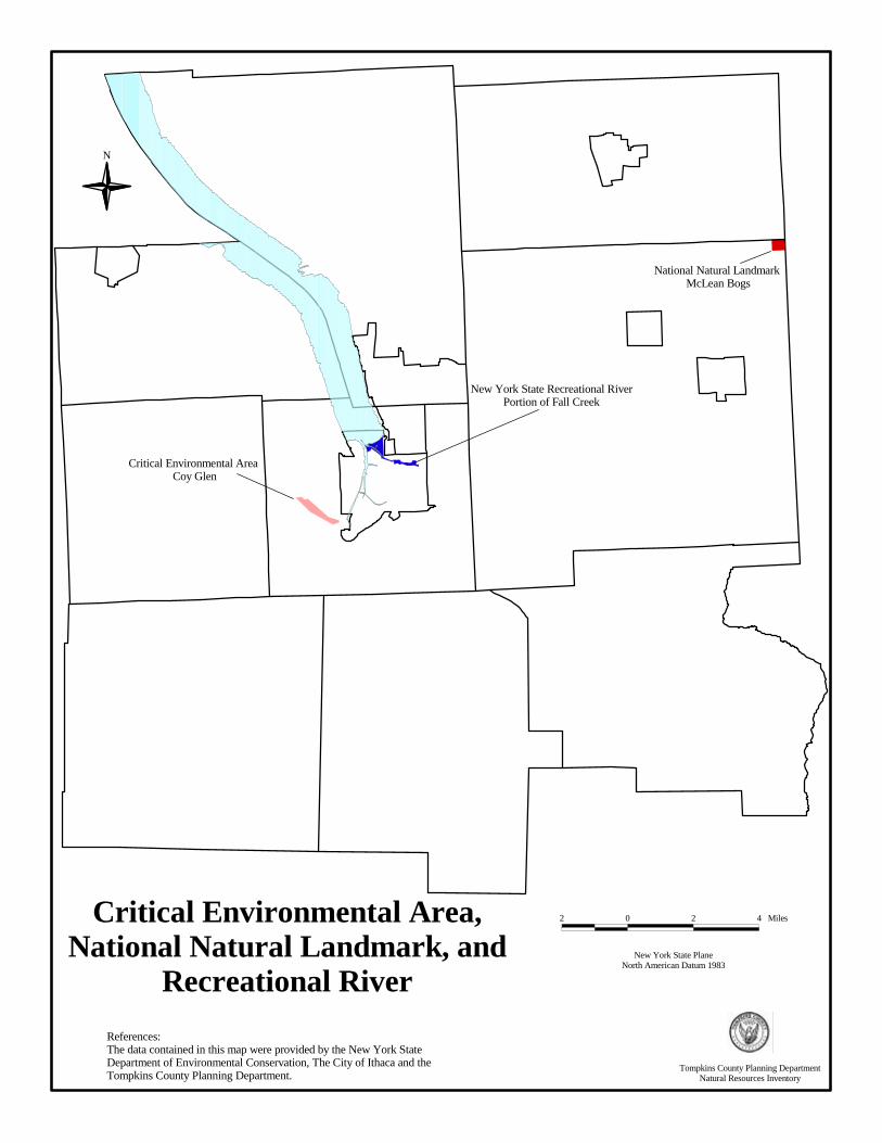
N
Critical Environmental Area,National Natural Landmark, and
Recreational River
References:The data contained in this map were provided by the New York StateDepartment of Environmental Conservation, The City of Ithaca and the Tompkins County Planning Department.
New York State PlaneNorth American Datum 1983
2 0 2 4 Miles
New York State Recreational RiverPortion of Fall Creek
Critical Environmental Area Coy Glen
National Natural Landmark McLean Bogs
Tompkins County Planning DepartmentNatural Resources Inventory
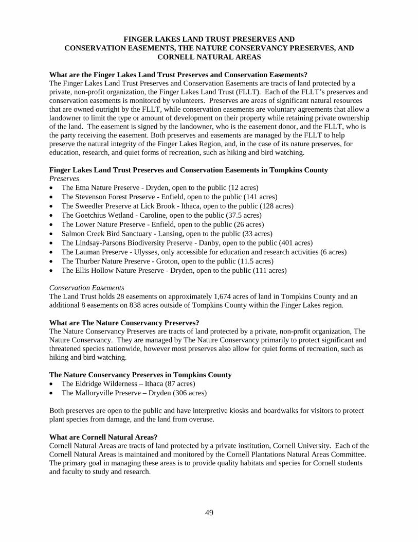
FINGER LAKES LAND TRUST PRESERVES AND CONSERVATION EASEMENTS, THE NATURE CONSERVANCY PRESERVES, AND
CORNELL NATURAL AREAS What are the Finger Lakes Land Trust Preserves and Conservation Easements? The Finger Lakes Land Trust Preserves and Conservation Easements are tracts of land protected by a private, non-profit organization, the Finger Lakes Land Trust (FLLT). Each of the FLLT’s preserves and conservation easements is monitored by volunteers. Preserves are areas of significant natural resources that are owned outright by the FLLT, while conservation easements are voluntary agreements that allow a landowner to limit the type or amount of development on their property while retaining private ownership of the land. The easement is signed by the landowner, who is the easement donor, and the FLLT, who is the party receiving the easement. Both preserves and easements are managed by the FLLT to help preserve the natural integrity of the Finger Lakes Region, and, in the case of its nature preserves, for education, research, and quiet forms of recreation, such as hiking and bird watching. Finger Lakes Land Trust Preserves and Conservation Easements in Tompkins County Preserves �� The Etna Nature Preserve - Dryden, open to the public (12 acres) �� The Stevenson Forest Preserve - Enfield, open to the public (141 acres) �� The Sweedler Preserve at Lick Brook - Ithaca, open to the public (128 acres) �� The Goetchius Wetland - Caroline, open to the public (37.5 acres) �� The Lower Nature Preserve - Enfield, open to the public (26 acres) �� Salmon Creek Bird Sanctuary - Lansing, open to the public (33 acres) �� The Lindsay-Parsons Biodiversity Preserve - Danby, open to the public (401 acres) �� The Lauman Preserve - Ulysses, only accessible for education and research activities (6 acres) �� The Thurber Nature Preserve - Groton, open to the public (11.5 acres) �� The Ellis Hollow Nature Preserve - Dryden, open to the public (111 acres) Conservation Easements The Land Trust holds 28 easements on approximately 1,674 acres of land in Tompkins County and an additional 8 easements on 838 acres outside of Tompkins County within the Finger Lakes region. What are The Nature Conservancy Preserves? The Nature Conservancy Preserves are tracts of land protected by a private, non-profit organization, The Nature Conservancy. They are managed by The Nature Conservancy primarily to protect significant and threatened species nationwide, however most preserves also allow for quiet forms of recreation, such as hiking and bird watching. The Nature Conservancy Preserves in Tompkins County �� The Eldridge Wilderness – Ithaca (87 acres) �� The Malloryville Preserve – Dryden (306 acres) Both preserves are open to the public and have interpretive kiosks and boardwalks for visitors to protect plant species from damage, and the land from overuse. What are Cornell Natural Areas? Cornell Natural Areas are tracts of land protected by a private institution, Cornell University. Each of the Cornell Natural Areas is maintained and monitored by the Cornell Plantations Natural Areas Committee. The primary goal in managing these areas is to provide quality habitats and species for Cornell students and faculty to study and research.
49
Cornell Natural Areas in Tompkins County Off Campus: �� Palmer-Adams Preserve at Bald Hill (146 acres) �� Fischer Old-Growth Forest at Cayuga Inlet Valley (34 acres) �� Russell Wildlife Preserve at Cayuga Marsh (27 acres) �� James W. and Helene D. Allen Wetland Preserve at Cayuga Lake (95 acres) �� Carter Creek at Connecticut Hill (426 acres) �� Coy Glen (127 acres) �� Conwell Tract (20 acres), Travis Wildflower Preserve (24 acres), and Durland Bird Sanctuary (173
acres) at Ellis Hollow Wetlands �� Fringed Gentian Natural Area (31 acres), Radio Lab Fields (151 acres), and Cornell Experimental
Ponds at Etna Fringed Gentian Area �� Howard Edward Babcock Preserve at Lick Brook (27 acres) �� Biological Station at Lighthouse Point (15 acres) �� Monkey Run Natural Area at Monkey Run (500+ acres) �� Frost Ravine (31 acres), Mount Pleasant Farm (600+ acres), and Pine Woods (204 acres) at Mount
Pleasant �� Newman Preserve at Renwick Slope (6 acres) �� Slaterville Wildflower Preserve (379 acres) and Williams Preserve (38 acres) at Slaterville 600 �� Polson Preserve at Snyder Hill (95 acres) �� Astronomy Lab in South Danby (60 acres) �� Jane E. Hardy Preserve at Steep Hollow Creek (3 acres) �� Jane McDaniel Tract at Townley Swamp (62 acres) On Campus: �� There are 24 Natural Areas on and near the Cornell University campus (approximately 500 acres). All Natural Areas are open for public visits, however, large groups should notify Cornell Plantations prior to visiting the site. Why are these Preserves, Conservation Easements, and Natural Areas Important? Nature preserves, conservation easements, and natural areas protect important lands from development and uses that may damage their natural features. These lands protect key plant and animal species and their habitats, protect watersheds and the quality of water in the area, and provide recreational opportunities to everyone. They also add economic value to their surrounding areas by enhancing tourism and increasing land values. In addition, they provide important educational opportunities for teaching about botany, natural history, entomology, etc. Although municipal governments do not have direct control of these lands, they may be able to use them in their planning efforts to create greenways, biological corridors, and recreational trails. Maps and Data For a map of this information, in paper or digital format, contact the Tompkins County Planning Department. For information on Finger Lakes Land Trust Preserves and Conservation Easements, contact the Finger Lakes Land Trust. For information on The Nature Conservancy Preserves, contact The Nature Conservancy. For information on Cornell Natural Areas, contact the Cornell Plantations. Resources and References Cornell Plantations, Cornell University, One Plantations Road, Ithaca, NY 14851; Phone: 607-255-3020; Fax: 607-255-2404; http://www.plantations.cornell.edu Finger Lakes Land Trust: http://www.fllt.org/ 202 East Court Street, Ithaca, NY 14850; Phone: 607-275-9487; Fax: 607-275-0037 Ostman, Nancy L. and F. Robert Wesley. 1997. Field Guide to Cornell’s Off-Campus Natural Areas. Cornell Plantations.
50

Ostman, Nancy L. and F. Robert Wesley. 1999. Field Guide to Cornell’s Natural Areas On and Near Campus. The Nature Conservancy: http://www.tnc.org Central & Western New York Chapter Office, 339 East Avenue, Suite 300, Rochester, NY 14604-2615; Phone: 716-546-8030 Fax: 716-546-7825
Tompkins County Planning Department, 121 East Court Street, Ithaca, NY 14850, 607-274-5560.
51
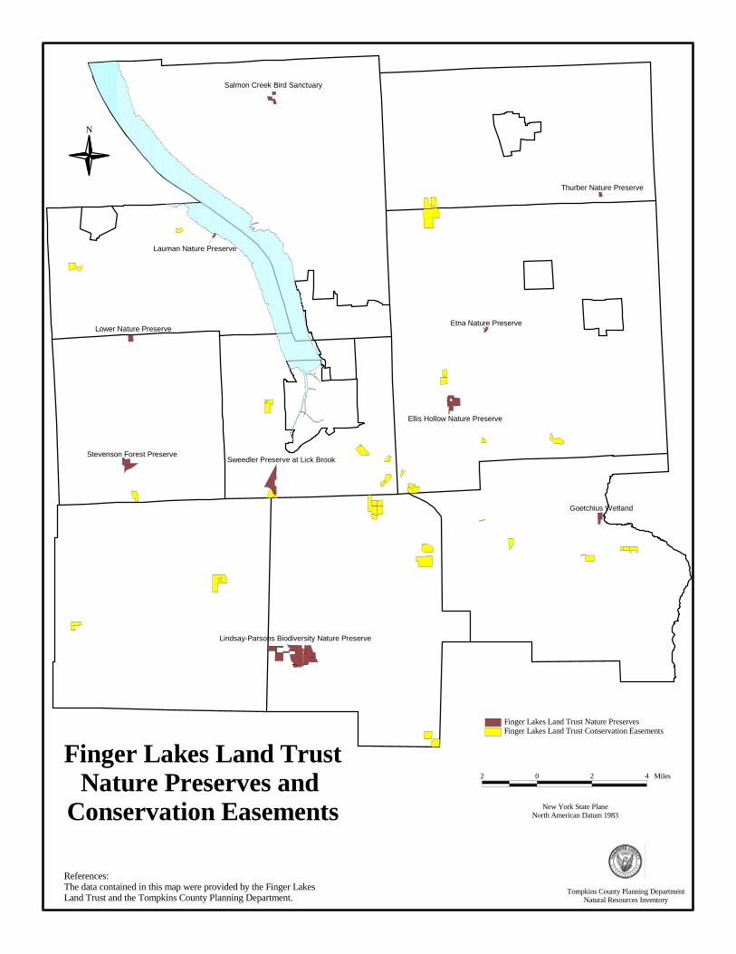
Lindsay-Parsons Biodiversity Nature Preserve
Sweedler Preserve at Lick Brook
Ellis Hollow Nature Preserve
Stevenson Forest Preserve
Lower Nature Preserve
Goetchius Wetland
Salmon Creek Bird Sanctuary
Etna Nature Preserve
Thurber Nature Preserve
Lauman Nature Preserve
Finger Lakes Land TrustNature Preserves and
Conservation Easements
N
References:The data contained in this map were provided by the Finger Lakes Land Trust and the Tompkins County Planning Department.
New York State PlaneNorth American Datum 1983
2 0 2 4 Miles
Finger Lakes Land Trust Conservation EasementsFinger Lakes Land Trust Nature Preserves
Tompkins County Planning DepartmentNatural Resources Inventory
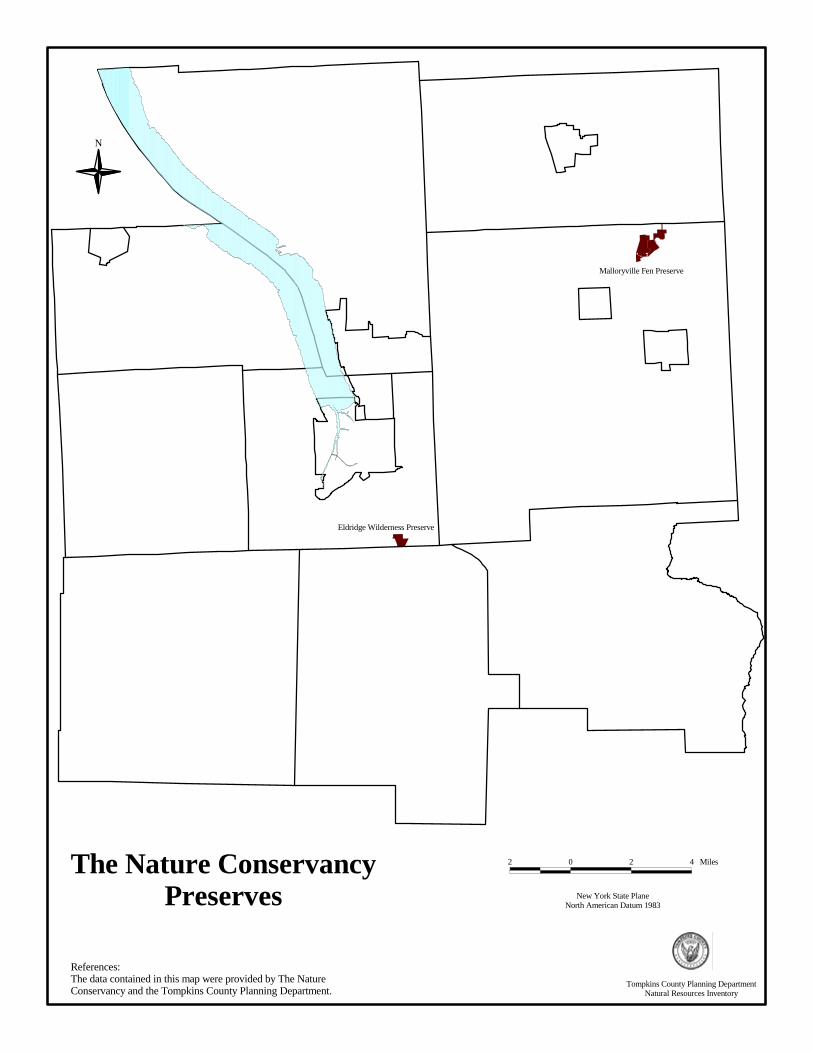
New York State PlaneNorth American Datum 1983
2 0 2 4 Miles
References:The data contained in this map were provided by The Nature Conservancy and the Tompkins County Planning Department.
N
The Nature ConservancyPreserves
Malloryville Fen Preserve
Eldridge Wilderness Preserve
Tompkins County Planning DepartmentNatural Resources Inventory
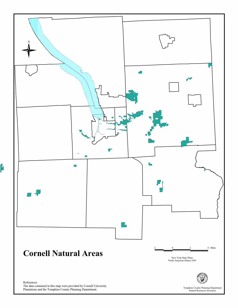
Cornell Natural Areas
N
New York State PlaneNorth American Datum 1983
2 0 2 4 Miles
References:The data contained in this map were provided by Cornell University Plantations and the Tompkins County Planning Department. Tompkins County Planning Department
Natural Resources Inventory
AERIAL PHOTOGRAPHS What are Aerial Photographs? Aerial photographs are images of the land taken from an airplane and printed on 9”x9” photographic paper. Why are Aerial Photographs Important? Aerial photographs are a useful tool in studying changes on the surface of the earth over time. They are particularly valuable in land use and land cover analyses, and comparing older data sets with new information. They are a record of what was on the land at the time the photograph was taken, and can be used for many types of studies. Aerial Photographs in Tompkins County Aerial photographs exist for Tompkins County for each decade since 1938. A Cornell University aerial photograph library houses aerial photographs for Tompkins County and other counties in New York State (also dating back to 1938). An important fly-over was conducted in 1992, when Tompkins County, in a consortium with New York State Electric and Gas and the City of Ithaca, contracted to have black and white photographs taken of the County. These black and white aerial photos of Tompkins County were taken at a scale of 1:12,000. The consortium also mapped the planimetric data (the buildings, roads, waterways, and other items) in order to make it geographically correct. A specialized process was used to orthographically draw and locate the data that was captured in these photos. These data sets are now available in a GIS format and are used to produce maps for Tompkins County. The most recent aerial photographs of Tompkins County were taken in the spring of 1999, before the tree leaves emerged. The result of that fly-over was a set of natural color photographs of the entire County that can be viewed in three dimensions with a stereoscope. Maps and Data Aerial photographs contain distortions and, therefore, are unreliable for measuring distances unless they are orthographically rectified (a process that takes the distortion out of photographs). Conventional aerial photographs contain image displacements caused by camera lens distortion, camera tip and tilt, terrain relief, and scale. These types of distortions are removed through a process of rectifying the original photographs to create a computer file referred to as a digital orthophoto. The data set compiled from the 1999 aerial photographs has not yet been rectified for the County, however, the City of Ithaca has digitized and rectified some of these images for their purposes. Maps can be generated from aerial photographs. For example, the 1995 Land Use and Land Cover Inventory of Tompkins County was created by using digital images (see DOQQs section), as well as aerial photographs, to interpret the land uses. Highly specialized processes are used to turn information from photographs into useful maps. For a map of this information, in paper or digital format, contact the Tompkins County Planning Department. References and Resources: City of Ithaca Planning Department, City Hall, 108 E. Green Street, Ithaca, NY 14850 607-274-6550 Institute for Resource Information Systems (IRIS), Rice Hall, Cornell University, Ithaca, NY 14850, 607-255-0800. Tompkins County GIS Program, Information Technical Services, 128 East Buffalo Street, Ithaca, NY 14850, 607-274-5418. http://www.tompkins-co.org/gis Tompkins County Planning Department, 121 East Court St, Ithaca, NY 14850 607-274-5560.
55

References:The data contained in this map were provided by the Tompkins County GIS Division, The City of Ithaca, Michael Baker Jr. Inc, and the Tompkins County Planning Department.
N
1992 Black and White Aerial Photograph
Tompkins County Planning DepartmentNatural Resources Inventory
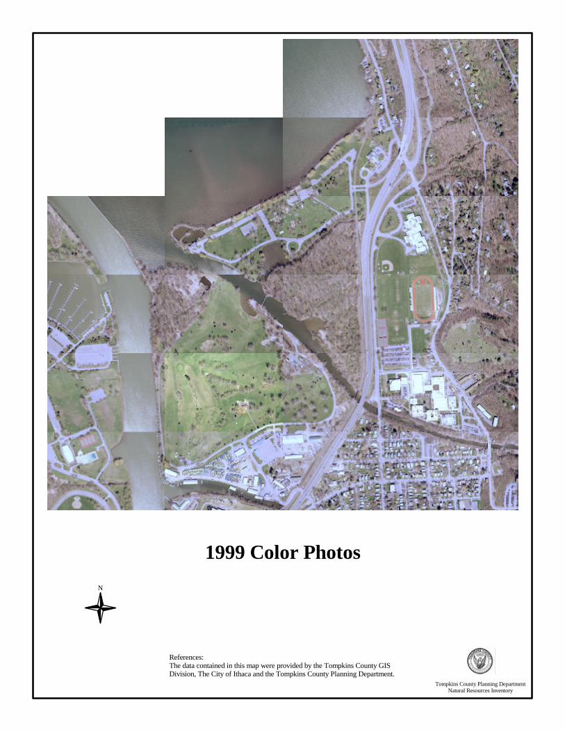
1999 Color Photos
N
References:The data contained in this map were provided by the Tompkins County GIS Division, The City of Ithaca and the Tompkins County Planning Department.
Tompkins County Planning DepartmentNatural Resources Inventory
DIGITAL ORTHOGRAPHIC QUARTER QUADRANGLES (DOQQS) What are Digital Orthographic Quarter Quadrangles? Digital Orthographic Quarter Quadrangles (DOQQs) are geographically corrected digital images of the surface of the earth. Conventional aerial photographs, as described in the previous section, contain image displacements caused by camera lens distortion, camera tip and tilt, terrain relief, and scale. These types of distortions are removed through a process of rectifying the original photographs to create a computer file referred to as a digital orthophoto. A number of these digital orthophotos are merged together to create a single DOQQ. These digital orthophotos were produced at a scale of 1:12,000 in quarter quadrangles (one quarter of a 7.5 minute USGS quadrangle). Why are Digital Orthographic Quarter Quadrangles Important? As with conventional aerial photographs, various land cover and land use features can be interpreted from DOQQ images. The DOQQs are an excellent record of the land’s surface at the time the images are taken. They can be viewed, using a geographic information system (GIS), with other Tompkins County digital data sets, such as tax parcels, road names, or hydrology, to assist planners in identifying land use and land cover features during site development reviews. The DOQQs prepared from the 1995 fly-over of Tompkins County have been used to create a detailed land use and land cover (LULC) digital data set for Tompkins County. Since DOQQs are geographically correct, accurate measurements can be taken from these images. This can be most helpful when the distance between land features needs to be determined and areas of particular features, such as forests and water bodies, need to be calculated for research and analytical purposes. Digital Orthographic Quarter Quadrangles Images in Tompkins County In Tompkins County, the majority of the imagery was captured from sensors in airplanes as part of the National Aerial Photography Program (NAPP) in March and April of 1995, with a few areas photographed in April 1994. The next set of DOQQs for Tompkins County is scheduled for flight, production, and distribution in 2002. The 1995 images were captured with a color-infrared sensor. Color infrared is ideal for differentiating wet and dry areas and various types of vegetation and vegetative health. In color infrared images, live vegetation appears in various shades of red and pink; buildings and roads appear light gray/white; water appears dark blue/black; and barren/dormant ground appears green/brown. Since the NAPP images were captured in the early spring, before most broad-leaf deciduous plants leafed out, these plants appear black; the dark red areas represent coniferous vegetation; and the light red or pink areas represent grass and/or early field crops. There is significant color variation among the different DOQQs (lighter vs. darker and/or redder vs greener) due to the variation in light and moisture that occurred over the time period during which the NAPP images were captured. Maps and Data To order Digital Orthographic Quarter Quadrangles contact the United States Geological Survey, EROS Data Center. For a map of this information, in paper format, contact the Tompkins County Planning Department, 121 East Court Street, Ithaca, NY, (607) 274-5560. Resources and References New York State DEC, 625 Broadway, Albany, NY 12233. http://www.nysgis.state.ny.us/orthoprogram.htm Tompkins County GIS Program, Information Technical Services, 128 East Buffalo Street, Ithaca, NY 14850, 607-274-5418. http://www.tompkins-co.org/gis
58

Tompkins County Planning Department, 121 East Court Street, Ithaca, NY 14850, 607-274-5560. United States Geological Survey, EROS Data Center, Sioux Falls, South Dakota, 57198, 605-594-6151, Fax: 605-594-6589. Email: [email protected]. Website: http://edcwww.cr.usgs.gov/eros-home.html.
59

References:The data contained in this map were provided by the New York State Department of Environmental Conservation and the Tompkins County Planning Department.
N
New York State PlaneNorth American Datum 1983
500 0 500 1000 1500 Feet
1995 Digital Orthographic ImageOne inch equals 1000 feet
Tompkins County Planning DepartmentNatural Resources Inventory
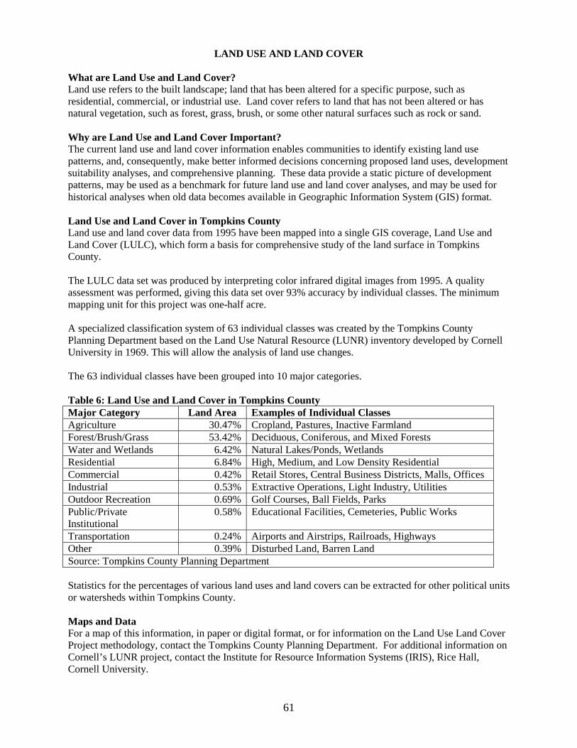
LAND USE AND LAND COVER What are Land Use and Land Cover? Land use refers to the built landscape; land that has been altered for a specific purpose, such as residential, commercial, or industrial use. Land cover refers to land that has not been altered or has natural vegetation, such as forest, grass, brush, or some other natural surfaces such as rock or sand. Why are Land Use and Land Cover Important? The current land use and land cover information enables communities to identify existing land use patterns, and, consequently, make better informed decisions concerning proposed land uses, development suitability analyses, and comprehensive planning. These data provide a static picture of development patterns, may be used as a benchmark for future land use and land cover analyses, and may be used for historical analyses when old data becomes available in Geographic Information System (GIS) format. Land Use and Land Cover in Tompkins County Land use and land cover data from 1995 have been mapped into a single GIS coverage, Land Use and Land Cover (LULC), which form a basis for comprehensive study of the land surface in Tompkins County. The LULC data set was produced by interpreting color infrared digital images from 1995. A quality assessment was performed, giving this data set over 93% accuracy by individual classes. The minimum mapping unit for this project was one-half acre. A specialized classification system of 63 individual classes was created by the Tompkins County Planning Department based on the Land Use Natural Resource (LUNR) inventory developed by Cornell University in 1969. This will allow the analysis of land use changes. The 63 individual classes have been grouped into 10 major categories. Table 6: Land Use and Land Cover in Tompkins County Major Category Land Area Examples of Individual Classes Agriculture 30.47% Cropland, Pastures, Inactive Farmland Forest/Brush/Grass 53.42% Deciduous, Coniferous, and Mixed Forests Water and Wetlands 6.42% Natural Lakes/Ponds, Wetlands Residential 6.84% High, Medium, and Low Density Residential Commercial 0.42% Retail Stores, Central Business Districts, Malls, Offices Industrial 0.53% Extractive Operations, Light Industry, Utilities Outdoor Recreation 0.69% Golf Courses, Ball Fields, Parks Public/Private Institutional
0.58% Educational Facilities, Cemeteries, Public Works
Transportation 0.24% Airports and Airstrips, Railroads, Highways Other 0.39% Disturbed Land, Barren Land Source: Tompkins County Planning Department Statistics for the percentages of various land uses and land covers can be extracted for other political units or watersheds within Tompkins County. Maps and Data For a map of this information, in paper or digital format, or for information on the Land Use Land Cover Project methodology, contact the Tompkins County Planning Department. For additional information on Cornell’s LUNR project, contact the Institute for Resource Information Systems (IRIS), Rice Hall, Cornell University.
61

Resources and References Cornell University Geospatial Information Repository (CUGIR) http://cugir.mannlib.cornell.edu/ Institute for Resource Information Systems (IRIS), Rice Hall, Cornell University 607-255-0800.
Tompkins County GIS Program, Information Technical Services, 128 East Buffalo Street, Ithaca, NY 14850, 607-274-5418. http://www.tompkins-co.org/gis Tompkins County Planning Department, 121 East Court Street, Ithaca, NY 14850, 607-274-5560.
62
TOMPKINS COUNTY DEPARTMENT OF PLANNING James W. Hanson, Jr., AICP, Commissioner of Planning Katherine Borgella, AICP, Land Programs Manager Jacquie Bow, Geographic Information System Analyst * Tom Chefalo, Information Systems Coordinator * Dariele Drake, Principal Account Clerk/Typist Karen Flores, Circuit Rider Planner * Kate Hackett, Water Resources Planner Sharon Heller, Geographic Information System Analyst Joan Jurkowich, AICP, Deputy Commissioner of Planning Tom Mank, Planning Analyst Mikel Shakarjian, Environmental Planner Kathy Wilsea, Secretary * former TCPD employees who contributed to the writing of this NRI
TOMPKINS COUNTY BOARD OF REPRESENTATIVES 2000-2001 Barbara Mink, Chair Barbara Blanchard Susanne Davis Dooley Kiefer * Michael Koplinka-Loehr Joseph M. Lalley Michael E. Lane Peter Penniman * Frank P. Proto Nancy B. Schuler Stuart W. Stein * Thomas L. Todd George L. Totman * Daniel M. Winch * * Members of the Planning Committee
64