toowoomba flood summary dec2010-jan2011 - bureau of meteorology
TRANSCRIPT
Flood summary for Toowoomba– December 2010 and January 2011
Flood summary for Toowoomba
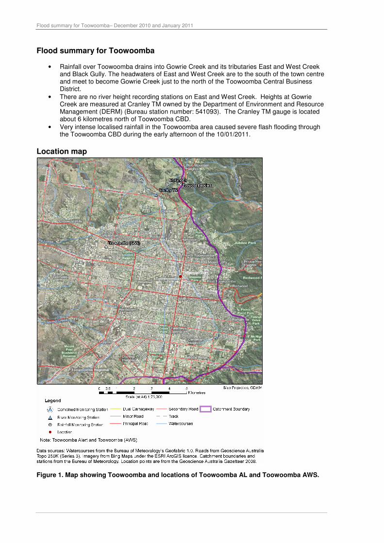
• Rainfall over Toowoomba drains into Gowrie Creek and its tributaries East and West Creek and Black Gully. The headwaters of East and West Creek are to the south of the town centre and meet to become Gowrie Creek just to the north of the Toowoomba Central Business District.
• There are no river height recording stations on East and West Creek. Heights at Gowrie Creek are measured at Cranley TM owned by the Department of Environment and Resource Management (DERM) (Bureau station number: 541093). The Cranley TM gauge is located about 6 kilometres north of Toowoomba CBD.
• Very intense localised rainfall in the Toowoomba area caused severe flash flooding through the Toowoomba CBD during the early afternoon of the 10/01/2011.
Location map
Figure 1. Map showing Toowoomba and locations of Toowoomba AL and Toowoomba AWS.

Flood summary for Toowoomba– December 2010 and January 2011
Rainfall summary
• Rainfall of between 600 and 1000mm was recorded in the Toowoomba area from 01/12/2010 to 31/01/2011 as shown in Figure 3.
• The vast majority of this rain fell between 09/01/2011and 13/01/2011 as shown in the rainfall maps in Figure 3 below.
• Rainfall in the Toowoomba area is recorded at the Toowoomba AWS owned by Bureau of Meteorology (Bureau station number: 540162) and Toowoomba Alert owned by Seqwater (Bureau station number: 041529). The Toowoomba Regional Council also has a meso-network of rainfall recording stations.
• A table listing the 24 hour rainfall figures recording at rainfall stations in the Toowoomba area to 9am on 11/01/2010 is shown in Table 1.
Figure 2. 24 Rainfall over the southeast quarter of Queensland from 01/12/2010 to 31/01/2011.

Flood summary for Toowoomba– December 2010 and January 2011
Figure 3. 24-Hour rainfall maps from 9am on 08/01/2011 to 9am on 12/01/2011.
Table 1. Rainfall recorded in the Toowoomba area in the 24-hours to 9am on 11/01/2011.
Station 24-hour rainfall to 9am on 11/01/2011
Toowoomba AWS 123.4
Toowoomba Alert 117
Middle Ridge 149.6
Withcott 180.8

Flood summary for Toowoomba– December 2010 and January 2011
Rainfall Intensity
• Maximum rainfall intensities for Toowoomba AL, which is located northeast of Toowoomba and Toowoomba Airport, are shown in Table 2.
• The most significant rainfall intensity for Toowoomba AL in January 2011 occurred in the 1 hour to 1:50pm on 10/01/2011, with rainfall amounts equalling the 2-5% Annual Exceedence Probability (20-50 year Average Recurrence Interval).
• The most significant rainfall intensities for Toowoomba Airport in January 2011 occurred in the 1 hour to 2:00pm on 10/01/2011 and 48 hours to 11:50am on 11/01/2011 with both equalling the 2-5% Annual Exceedence Probability (20-50 year Average Recurrence Interval).
Table 2. Recorded maximum rainfall intensities for Toowoomba AL and Toowoomba Airport for January 2011.
Toowoomba AL Toowoomba Airport Rainfall Duration
Rainfall (mm)
Period ending ARI
(years) Rainfall
(mm) Period ending
ARI (years)
5 min 9 13:45:00 10/01/2011 2
6 min 10 13:46:00 10/01/2011 1-2
10 min 14 13:45:00 10/01/2011 1-2
20 min 27 13:45:00 10/01/2011 5
30 min 36 13:50:00 10/01/2011 10
1hr 58 13:50:00 10/01/2011 20-50 60 2:00 PM 10/01/2011 20-50 2hr 65 14:15:00 10/01/2011 10-20 68 2:00 PM 10/01/2011 20 3hr 67 15:40:00 10/01/2011 5-10 73 4:00 PM 10/01/2011 10-20 6hr 75 16:55:00 10/01/2011 2-5 87 5:00 PM 10/01/2011 10-20 12hr 88 16:55:00 10/01/2011 2-5 99 5:00 PM 10/01/2011 5-10 24hr 134 6:00:00 10/01/2011 5-10 154 4:00 PM 10/01/2011 10-20 48hr 197 11:20:00 11/01/2011 10-20 208 11:00 AM 11/01/2011 20-50 72hr 218 19:15:00 11/01/2011 10-20 233 9:00 AM 12/01/2011 10-20
Note: A flood frequency analysis would be required to assess the probability of flood levels reached at each location.
The frequency analysis in this report is for rainfall only.
Flash Flood event timeline Table 3. Flash flood event timeline for Toowoomba on the 10/01/2011.
Time/Date Event Description
10:55 AM 09/01/2011 First Severe Weather Warning for Flash Flooding over the Darling Downs and Southeast Coast region.
12:45 PM 10/01/2011 Redbank Creek AL recorded intense hourly rainfall of 87 mm.
12:45 PM 10/01/2011 Heavy rainfall commenced in eastern parts of Toowoomba CBD. The peak rainfall occurred sometime between 12.45pm and 2.15pm. Totals of 138mm were recorded at Toowoomba Regional Council rain gauges. Higher rainfalls are considered likely.
2:00 PM 10/01/2011
Estimated time water level peaked in the Toowoomba CBD (Source: Insurance Council Australia – “The nature and causes of flooding in Toowoomba 10 January 2011.”)
2:20 PM 10/01/2011* The flood peak at Cranley TM reached an estimated peak of 4.6 metres. This figure followed a post flood survey conducted by DERM.
5:06 PM 11/01/2011 Final Severe Weather warning for flash flooding over the Darling Downs.
* Time was estimated from observations.

Flood summary for Toowoomba– December 2010 and January 2011
Flood Heights at Cranley TM on Gowrie Creek
Figure 4. Flood Heights at Cranley TM for the 01/12/2010 to 14/01/2011. Reconstructed by adding in surveyed peak height. No flood classifications exist for Cranley TM.
Figure 5. Flood Heights at Cranley TM for the 08/01/2010 to 14/01/2011. Reconstructed by adding in surveyed peak height. No flood classifications exist for Cranley TM. Note: The recession at Cranley TM (above) was not recorded as gas line was washed away during flood. Therefore the above diagram does not represent a normal recession of heights at Cranley TM.

Flood summary for Toowoomba– December 2010 and January 2011
Warning and Forecast Service
• The Bureau does not provide a flood warning service for Toowoomba
• Severe Weather warnings for heavy rainfall and flash flooding were issued covering the Toowoomba area from 4.40am Sunday 9/1/2010 until 10pm Tuesday 11/01/2011.
Date Time Header
Sunday 9 January
2011
4:40 am
SEVERE WEATHER WARNING for heavy rainfall leading to localised flash flooding and potentially worsening the existing river flood situation For people in the Southeast Coast district and southern parts of the Wide Bay and Burnett. Issued at 4:40 am on Sunday 9 January 2011
Sunday 9 January
2011
10:55 am
SEVERE WEATHER WARNING for heavy rainfall leading to localised flash flooding and potentially worsening the existing river flood situation For people in the Southeast Coast district, southern parts of the Wide Bay and Burnett, and eastern Darling Downs and Granite Belt District. Issued at 10:55 am on Sunday 9 January 2011
Sunday 9 January
2011
4:55 pm
SEVERE WEATHER WARNING for heavy rainfall leading to localised flash flooding and potentially worsening the existing river flood situation For people in the Southeast Coast district, southern parts of the Wide Bay and Burnett, and eastern Darling Downs and Granite Belt District. Issued at 4:55 pm on Sunday 9 January 2011
Sunday 9 January
2011
11:00 pm
SEVERE WEATHER WARNING for heavy rainfall leading to localised flash flooding and potentially worsening the existing river flood situation For people in the Southeast Coast district, southern parts of the Wide Bay and Burnett district and eastern parts of the Darling Downs and Granite Belt district. Issued at 11:00 pm on Sunday 9 January 2011
Monday 10 January
2011
5:00 am
SEVERE WEATHER WARNING for heavy rainfall leading to localised flash flooding and potentially worsening the existing river flood situation For people in the Southeast Coast district, southern parts of the Wide Bay and Burnett district and eastern parts of the Darling Downs and Granite Belt district. Issued at 5:00 am on Monday 10 January 2011
Monday 10 January
2011
11:00 am
SEVERE WEATHER WARNING for heavy rainfall leading to localised flash flooding and potentially worsening the existing river flood situation For people in the Southeast Coast district, southern parts of the Wide Bay and Burnett district and eastern parts of the Darling Downs and Granite Belt district. Issued at 11:00 am on Monday 10 January 2011
Monday 10 January
2011
11:05 am
SEVERE WEATHER WARNING for heavy rainfall leading to localised flash flooding and potentially worsening the existing river flood situation For people in the Southeast Coast district, southern parts of the Wide Bay and Burnett district and eastern parts of the Darling Downs and Granite Belt district. Issued at 11:05 am on Monday 10 January 2011
Monday 10 January
2011
5:05 pm
SEVERE WEATHER WARNING for heavy rainfall leading to localised flash flooding and potentially worsening the existing river flood situation For people in the Southeast Coast district, far southern parts of the Wide Bay and Burnett district and eastern parts of the Darling Downs and Granite Belt district. Issued at 5:05 pm on Monday 10 January 2011
Monday 10 January
2011
6:30 pm
SEVERE WEATHER WARNING for heavy rainfall leading to localised flash flooding and potentially worsening the existing river flood situation For people in the Southeast Coast, Darling Downs and Granite Belt and eastern parts of the Maranoa and Warrego districts. Issued at 6:30 pm on Monday 10 January 2011
Monday 10 January
2011
7:50 pm
SEVERE WEATHER WARNING for heavy rainfall leading to localised flash flooding and potentially worsening the existing river flood situation For people in the Southeast Coast, Darling Downs and Granite Belt, far southern parts of the Wide Bay and Burnett and eastern parts of the Maranoa and Warrego districts. Issued at 7:50 pm on Monday 10 January 2011
Monday 10 11:00 SEVERE WEATHER WARNING for heavy rainfall leading to localised flash

Flood summary for Toowoomba– December 2010 and January 2011
January 2011
pm flooding and potentially worsening the existing river flood situation For people in the Southeast Coast, Darling Downs and Granite Belt, far southern parts of the Wide Bay and Burnett and eastern parts of the Maranoa and Warrego districts. Issued at 11:00 pm on Monday 10 January 2011
Tuesday 11 January
2011
5:05 am
SEVERE WEATHER WARNING for heavy rainfall leading to localised flash flooding and potentially worsening the existing river flood situation For people in the Southeast Coast, Darling Downs and Granite Belt, far southern parts of the Wide Bay and Burnett and eastern parts of the Maranoa and Warrego districts. Issued at 5:05 am on Tuesday 11 January 2011
Tuesday 11 January
2011
8:00 am
SEVERE WEATHER WARNING for heavy rainfall leading to localised flash flooding and worsening the existing river flood situation For people in the Southeast Coast District and the Darling Downs and Granite Belt District southeast of Dalby to Goondiwindi. Issued at 8:00 am on Tuesday 11 January 2011
Tuesday 11 January
2011
11:00 am
SEVERE WEATHER WARNING for heavy rainfall leading to flash flooding and worsening the existing river flood situation For people in the Southeast Coast District and the Darling Downs and Granite Belt District southeast of Dalby to Goondiwindi. Issued at 11:00 am on Tuesday 11 January 2011
Tuesday 11 January
2011
2:00 pm
SEVERE WEATHER WARNING for heavy rainfall leading to flash flooding and worsening the existing river flood situation For people in the Southeast Coast District and the Darling Downs and Granite Belt District southeast of Dalby to Goondiwindi. Issued at 2:00 pm on Tuesday 11 January 2011
Tuesday 11 January
2011
5:00 pm
SEVERE WEATHER WARNING for heavy rainfall leading to flash flooding and worsening the existing river flood situation For people in the Southeast Coast District and the Darling Downs and Granite Belt District southeast of Dalby to Goondiwindi. Issued at 5:00 pm on Tuesday 11 January 2011
Tuesday 11 January
2011
10:00 pm
SEVERE WEATHER WARNING for heavy rainfall leading to flash flooding and worsening the existing river flood situation For people in the Southeast Coast District and the Darling Downs and Granite Belt District southeast of Dalby to Goondiwindi. Issued at 5:00 pm on Tuesday 11 January 2011