tourist guide ruta de las misiones
DESCRIPTION
ÂTRANSCRIPT

The Andean adventureAnti markanak uñjañataki
Tourist GuideArica y Parinacota, Chile.

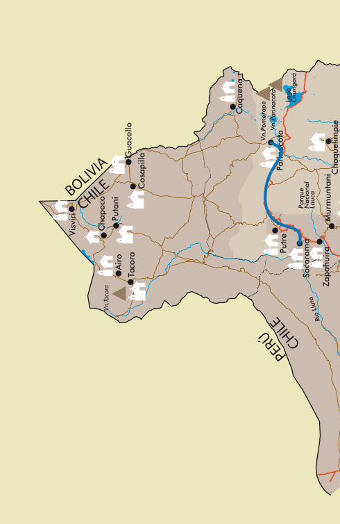
Following Page: 1. Parinacota Volcano 2. Salar de Surire 3. Assembly of the Patron Saints in Belén 4. Riding in foothills; 5. Church of San Pedro de Guañacagua 6. Archaeological ruins on Tignamar Tangane hill.

1
4
2
5
3
6
THE ANDEAN ADVENTUREThe region of Arica and Parinacota can be seen as a cultural landscape of the Americas. It is set in the extraordinary scenery between the Great Desert of the Pacific and the high plateau of the Andes, and has a cultural register dating back over 10,000 years. This cultural landscape is worthy of conservation as a heritage of humanity, and as a source to generate alternative forms of healthy development for future generations, so that they too will be inspired by the wisdom of the ancestral cultures that were able to survive and develop in harmony with their surroundings. In this day in age, tourism is orientated towards responsible conservation of the resources it promotes. The Mission Route supports the conservation of heritage in the Andean churches of Arica and Parinacota. It originated thanks to the economic and cultural opportunities that arose from the Ruta de Plata de Potosí-the route through which silver was transported from the mines of Potosí in Peru to the port of Arica. It also acts as a link between Chile and the Southern Andean area that it shares with Peru, Bolivia and Argentina. The objective of the Mission Route is to implement a tourism trail of heritage in the region of Arica and Parinacota, that is particularly rich in natural and cultural resources, in order to strengthen the Andean communities that exercise its custody, to promote its {repopulation} and to create a scheme of sustainable development that can be applied throughout the nation.This guide is a result of the Mission Route Project, a tourist trail for the foothills of Arica and Painacota, code 08CTU01-25, funded with FIC-R funds, supported by the Government of Chile through Innova Chile of Corfo. The work has been co-executed by the Centre of the Atacama Desert of the Pontificia Universidad Católica de Chile and the Fundación Altiplano MSV, with the support of the Bishopric of Arica and the Andean communities of Arica and Parinacota.


ARICA Y PARINACOTA: A CULTURAL LANDSCAPEThe district of Arica and Parinacota has been described by UNESCO1 as a cultural landscape, thanks to the efforts of nature and that of man. It is a region into which both nature and culture are so intimately integrated, and through its study we can appreciate alternative forms of development, ones that are healthy and enduring. Within the extensive trail of the Andes mountain range from Columbia to the South of Chile there is geographical and cultural area known as the “Andean South”, which corresponds to the central-southern section of the Andes, or the areas around Lake Titicaca that include Southern Peru, Bolivia, Northern Chile and North-Eastern Argentina. Here the mountainous areas are characterised by the plateaus called the Altiplano or Meseta del Collao, and the coastal areas by the Great Desert of the Pacific, containing the driest stretch of land on the planet, in Atacama. These extreme natural conditions have been the setting of remarkable cultural developments that survived and progressed in spite of the hostility of the environment, where mobility was key.
Within the Andean South the terrain of Arica and Parinacota is a cultural landscape that generates interest for its position, a strategic point on the continent, and its great natural and cultural diversity. This region can be divided into three ecological levels: the coast and low valleys- a desert zone with watercourses originating from the high Andean area that allow for the development of agriculture; the foothills of the Andes, of altitudes between 2000 to 3500m asl., with high desert climate and influence of the Altiplano winters, biological diversity and appropriate conditions to cultivate livestock and agriculture; and Puna or Altiplano, of altitudes between 3600 and 4700m asl., precipitation from December to March, biological diversity of native species and an abundance of pastures that allow for the domestication and breeding of livestock such as llamas and alpacas.
Arica and Parinacota was historically a strategic land, a natural path between the high plateau and the coast. In the same way as desert conditions determine the natural means, mobility is the key factor in the cultural development of the region, since communities will be in continuous pursuit to complement the limited resources available in their immediate habitat with that which they can obtain in the neighboring ecological levels.
In the Arcaic Period (8000-1500 BC) groups of hunter-gatherers lived in the plateau and the foothills, while in the coast groups of fishermen-collectors formed the denominating culture of the Chinchorro, whose techniques of mummification are considered as one of the treasures of the national heritage. During the Formative Period (1500-500 AD) in the plateau domestication of llama and alpaca was achieved, leading to nourishment, shelter and a means of transport that was necessary for the caravans that connected them with the coast. In the Middle Ages (500-1100 AD) the Tiwanaki Empire expanded towards the coast from Lake Titicaca, characterizing the cultural landscape of Arica and Parinacota with their dialect and world-view until today. In the Late-Intermediate Period (1100-1400 AD) there emerge the Regional Developments, among them the “Arican Culture”, that occupy the three ecological levels, signaling their caravan routes with geoglyphs in the Lluta and Azapa valleys. In the Inca Period, towards 1470, the expansion of the Tawantinsuyo integrates the region into the vast South Andean world, around the network of roads called Inca Trail or Qáhpac Ñam.
With the arrival of the Spaniards in 1536, the Inca Trail would be crucial for

the development of one of the most important chapters in the history of the Spanish Crown in South America, the “Ruta de la Plata de Potosí”. From 1574 Arica becomes the official port of the legendary mineral that constituted one of the principal sources of income of the Spanish Empire between the end of the 16th Century and the middle of the 18th Century. Herds of mule and llamas would be transported along the old paths, and their produce would be supplied to the Andean villages. The Spanish administration established the reduction system, for the submission and evangelicisation of the indigenous communities, and rustic temples would be built of adobe, stone and straw to house the mission, although the
After the Independence of Peru in 1821 the region becomes part of Arequipa. In 1868 and 1877 two strong earthquakes and tsunamis leave the city of Arica in ruins. Following the war of the Pacific (1879 -1882) between Chile, Peru and Bolivia, Chile integrates the region into its territory, generating a new process of colonisation that affects the historical and cultural entailment of Arica and Parinacota with the South-Andean world. The installation of the railroad linking Arica to La Paz in 1904 reactivates the city as a natural port of the Altiplano. In 1953, 24 years after the official incorporation of the region to Chilean territory, the President Carlos Ibañez Del Campo implements a plan of development, decreeing a free market and the creation of the Advancement Board of Arica (1958-1976). This promotes the ´Andean Plan ,́ which improves the road network and the basic services inland. In spite of this the Andean communities migrate to the port in search for stable work and better education for their children. During the military government, Arica loses its free market economy and the region suffers a long period of economic depression. To revert the situation there have been special development plans, and in 2007 the District of Arica and Parinacota is established.
In this day in age the Andean villages have connectivity and basica services, but they are barely inhabited. Being integrated into an exceptional cultural landscape, the Andean communities have great potential of development, based on the responsible use of the valuable resources of heritage that they protect, applying them to agriculture and livestock, renewable energy, investigation and tourism.
Since 2005, Fundación Altiplano and the Diocese of Arica take care of the conservation of religious heritage of the Andean communities in the restoration project of churches of Arica and Parinacota2. Based on this, it is presented to CORFO Innova a tourism project called Mission Road, which was designed and implemented in partnership with the Catholic University of Chile, between 2009 and 2011. Mission Road Project has been conceived as an alternative sustainable development, aimed at strengthening the Andean communities that have the safekeeping of the heritage in the region. The goal is to recover the vital role of the Andean communities as post, true oasis in the long and sacrificed desert route: “That in every post there is a Spanish or Cacique or other Indio that has in them the necessary supplies necessary for the walkers and horses and bread, wine, meat, corn, wood, grass and water”. Viceroy Toledo, 1571.
Magdalena Pereira C.Historian and Director of Fundación Altiplano MSV
1. World Heritage Cultural Landscapes 1992-2002. UNESCO World Heritage Centre. Paris, France.2. Restoration Plan Andean churches of Arica and Parinacota, sustainable development model. Altiplano MSV Foundation, 2011.
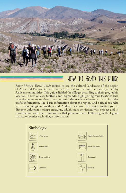
HOW TO READ THIS GUIDERoute Mission Travel Guide invites to see the cultural landscape of the region of Arica and Parinacota, with its rich natural and cultural heritage guarded by Andean communities. This guide divided the villages according to their geographic location in low valleys, foothills and highlands, highlighting four locations that have the necessary services to start or finish the Andean adventure. It also includes useful information, like basic information about the region, and a ritual calendar with major religious holidays and Andean customs. This guide invites you to discover unknown heritage treasures, which must be viisited with respect and in coordination with the communities that preserve them. Following is the legend that accompanies each village information.
Public Transportation
Other holidays Restaurant
Services
Room and boardPatron Saint
Directions
What to see:
Simbology:
Lago
C
hung
ará
Vn.P
omer
ape
Vn.P
arin
acot
a
Vn.Ta
cora
Parq
ue
Nac
iona
lLa
uca
Cho
quel
impi
e
Gua
collo
Mur
mun
tani
Zapa
huir
a
Soco
rom
a
Pari
naco
ta
Caq
uena
Cha
poco
Air
o
Vis
viri
Taco
ra
Puta
ni
Cos
apill
a
Putr
e
Río
Llut
a

Sala
r de
Sur
ire
Vn.G
ualla
tire
Co.
Mar
quez
Rese
rva
Nat
ural
Las
Vicu
ñas
Poco
nchi
le
Livi
lcar
Tim
ar
Parc
ohay
lla
Mul
luri
Pach
ama
Belé
n
Gua
llatir
e
Sucu
na
Esqu
iña
Pach
ica
Sagu
ara
Ticn
amar
Tula
palc
a
Cob
ija
Saxa
mar
Aza
pa
Gua
ñaca
gua
Tim
alch
aca
Río
San
José
Río
Vito
r
Ari
ca
Aic
oC
hitit
a
Cod
pa
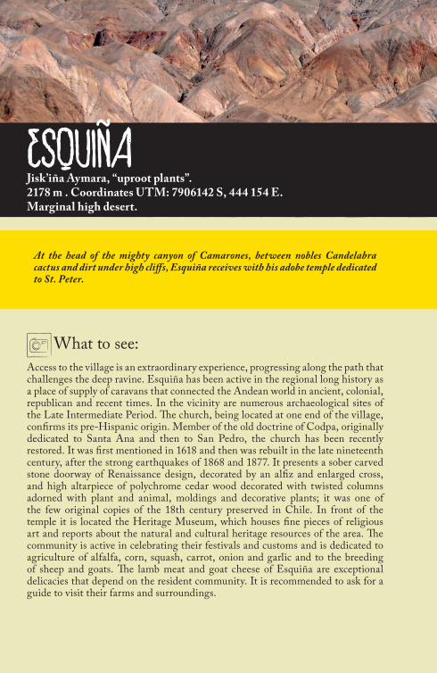
ESQUIÑAJisk’iña Aymara, “uproot plants”.2178 m . Coordinates UTM: 7906142 S, 444 154 E.Marginal high desert.
What to see:Access to the village is an extraordinary experience, progressing along the path that challenges the deep ravine. Esquiña has been active in the regional long history as a place of supply of caravans that connected the Andean world in ancient, colonial, republican and recent times. In the vicinity are numerous archaeological sites of the Late Intermediate Period. The church, being located at one end of the village, confirms its pre-Hispanic origin. Member of the old doctrine of Codpa, originally dedicated to Santa Ana and then to San Pedro, the church has been recently restored. It was first mentioned in 1618 and then was rebuilt in the late nineteenth century, after the strong earthquakes of 1868 and 1877. It presents a sober carved stone doorway of Renaissance design, decorated by an alfiz and enlarged cross, and high altarpiece of polychrome cedar wood decorated with twisted columns adorned with plant and animal, moldings and decorative plants; it was one of the few original copies of the 18th century preserved in Chile. In front of the temple it is located the Heritage Museum, which houses fine pieces of religious art and reports about the natural and cultural heritage resources of the area. The community is active in celebrating their festivals and customs and is dedicated to agriculture of alfalfa, corn, squash, carrot, onion and garlic and to the breeding of sheep and goats. The lamb meat and goat cheese of Esquiña are exceptional delicacies that depend on the resident community. It is recommended to ask for a guide to visit their farms and surroundings.
At the head of the mighty canyon of Camarones, between nobles Candelabra cactus and dirt under high cliffs, Esquiña receives with his adobe temple dedicated to St. Peter.
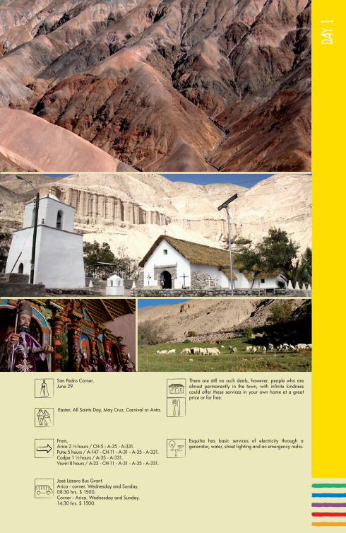
DAY
1
José Lázaro Bus Grant.Arica - corner. Wednesday and Sunday.08:30 hrs. $ 1500.Corner - Arica. Wednesday and Sunday.14:30 hrs. $ 1500.
Easter, All Saints Day, May Cruz, Carnival or Anta.
Esquiña has basic services of electricity through a generator, water, street lighting and an emergency radio.
San Pedro Corner.June 29.
From,Arica 2 ½ hours / CH-5 - A-35 - A-331.Putre 5 hours / A-147 - CH-11 - A-31 - A-35 - A-331.Codpa 1 ½ hours / A-35 - A-331.Visviri 8 hours / A-23 - CH-11 - A-31 - A-35 - A-331.
There are still no such deals, however, people who are almost permanently in the town, with infinite kindness could offer these services in your own home at a great price or for free.

What to see:The town of Codpa is located just hour and a half from Arica on a paved road in good condition, and in whose surroundings it is possible to find numerous natural and cultural attractions. The area has records of ancient human settlements like Ofragia where hundreds anthropomorphic and zoomorphic petroglyphs dated in the late pre-hispanic have been discovered. Codpa was of great importance in colonial times, center of Doctrine and central Indian Chiefdom. His church is first mentioned in the 17th century and it is probably a reconstruction of the 18th century. Formerly it was larger, but his nave was diminished in its last reconstruction, losing the high choir mentioned in documents of colonial times. One of its most valuable elements is the carved wooden pulpit, with images of the four evangelists. Also important is the collection of cultural goods, testimony of Codpa illustrious past as wine, wheat and fruit producing center, which supplied the region by mule and llama train. The courtyard of the temple reminisces Diego Felipe Cañipa martyr whose death is linked to the revolution of Tupac Amaru. Next to the temple, an ancient wine press celebrates the Valley winemaking tradition, which is celebrated annually with the massive Harvest Festival, in honor of the legendary wine of Codpa, also called Pintatani. The town has a small museum with archaeological and historical pieces and has excellent restaurant services, accommodation and guided tours to discover the rich natural and cultural heritage of the valley.
CODPAQullpa Aymara, “salty type” Q `tupa: “grass mud”.1867 m. Coordinates UTM: 421606, 15 E/7917425, 76 S.Desert.
Codpa is a miracle in the midst of extreme aridity of the Great Desert. The Valley hosts the old town, called in the past “The capital”, which has been active in the noble history of the region and with its centuries-old vineyards that still produce a exceptional wine.
© R
odri
go V
illal
ón

DAY
1
From,Arica 1 ½ hours / CH-5 - A-35.Putre 3 1/2 hours / A-147 - CH-11 - A-31 - A-35.Visviri 7 hours / A-23 - CH-11 - A-31 - A-35.
Virgen de la Candelaria, Carnival or Anata, Easter, Christmas Party, Fiesta de los Reyes Magos, May Cruz, Machaq mara, Harvest Feast and All Saints Day.
St. Martin of Tours.10, 11, 12 November.
- La Paloma.Arica-Codpa. Monday, Wednesday and Friday. 08:30 am $ 2500.Codpa-Arica. Monday, Wednesday and Friday. 16:00 hrs $ 2500.- Bus Transportation Grant José Lázaro.Arica - Codpa, Thursday and Saturday.08:00 hrs. $ 1400.Codpa - Arica, Thursday and Saturday.16:00 hrs. $ 1400.
Felicinda Ms. Romero. “Restaurante Doña Fely”.Value Menu $ 2000.
- Family Pensions. Mr. Ruben Chamorro.3 bedrooms with private bathroom.It offers breakfast, lunch, tea or dinner.Price: $ 800 breakfast or eleven p/p. Lunch. $ 2000 p/p.- Hotel. Codpa Valley Lodge.Contact: Mr. David Bravo ([email protected]).DBL or SGL 16 cabins to accommodate up to 32 people, a restaurant open every day of the year and pool.Rates: Room SGL $ 80. Breakfast included.DBL Room $ 100. Breakfast included.Reservations in Santiago: 56-2-2351519, 56-9-84491092.Visit www.codpavalleylodge.blogspot.com.
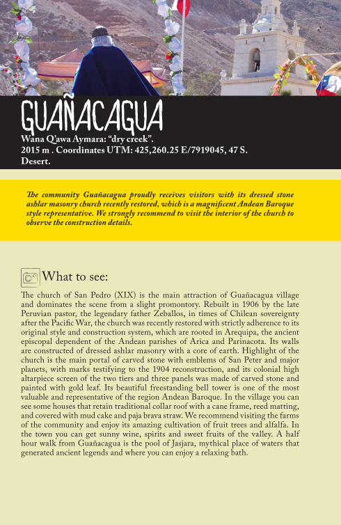
What to see:The church of San Pedro (XIX) is the main attraction of Guañacagua village and dominates the scene from a slight promontory. Rebuilt in 1906 by the late Peruvian pastor, the legendary father Zeballos, in times of Chilean sovereignty after the Pacific War, the church was recently restored with strictly adherence to its original style and construction system, which are rooted in Arequipa, the ancient episcopal dependent of the Andean parishes of Arica and Parinacota. Its walls are constructed of dressed ashlar masonry with a core of earth. Highlight of the church is the main portal of carved stone with emblems of San Peter and major planets, with marks testifying to the 1904 reconstruction, and its colonial high altarpiece screen of the two tiers and three panels was made of carved stone and painted with gold leaf. Its beautiful freestanding bell tower is one of the most valuable and representative of the region Andean Baroque. In the village you can see some houses that retain traditional collar roof with a cane frame, reed matting, and covered with mud cake and paja brava straw. We recommend visiting the farms of the community and enjoy its amazing cultivation of fruit trees and alfalfa. In the town you can get sunny wine, spirits and sweet fruits of the valley. A half hour walk from Guañacagua is the pool of Jasjara, mythical place of waters that generated ancient legends and where you can enjoy a relaxing bath.
GUAÑACAGUAWana Q’awa Aymara: “dry creek”.2015 m . Coordinates UTM: 425,260.25 E/7919045, 47 S.Desert.
The community Guañacagua proudly receives visitors with its dressed stone ashlar masonry church recently restored, which is a magnificent Andean Baroque style representative. We strongly recommend to visit the interior of the church to observe the construction details.

DAY
1
Feast of the Kings, Day of the Dead, Carnival, Easter and Christmas.
Guañacagua has power utilities, local diesel generator and solar panel, drinking water from pond. Health services are in Codpa, where a Rural Posta. It performs a medical round once a month to the village. There is also a payphone and TVN signal.
Mr. Domingo Mamani. Prompt for the village.5 rooms with 12 beds. $ 6000 p/p including breakfast.Horseback. Mr. Roberto Guerrero, operates as a tour guide in the trip.Rent of horses for horseback riding through the valley of Codpa. 5 horses available.
Mrs. Elsa Nina offers a menu full day with a value of $ 6000 plus VAT, which includes breakfast, lunch, tea and dinner.Telephone for reservations 56-9-74958209.
St. Peter and Paul.June 29.
From,Arica 1 ½ hours / CH-5 - A-35.Putre 4 hours 7 / A-147 - CH-11 - A-31 - A-35.Codpa ½ hours / A-35.Visviri 7 hours / A-23 - CH-11-A-31 - A-35.
Public Transportation La Paloma.Arica - Guañacagua. Monday, Wednesday and Friday. 08:30 hrs. $ 2500.Guañacagua - Arica. Monday, Wednesday and Friday. 15:30 hrs. $ 2500.Government Transport Grant José Lázaro.Arica - Guañacagua. Thursday and Saturday.08:00 hrs. $ 1400.Guañacagua - Arica. Thursday and Saturday.15:30 hrs. $ 1400.

What to see:Surrounded by cactus tunales, pears, plums, apricots, avocados, guavas and alfalfa grown in ancient terraces, the village of Chitita indicates the beginning of the fertile Codpa valley located a hundred meters distance from a pre-Hispanic village nestled at the top of the ravine, alongside the noble cactus Candelabro. Its adobe church, dedicated to the Virgin of Carmen (XIX) and recently restored, has an access created by a semicircular arch and smooth columns topped in scallops, classic decorative style used in Andean Baroque. Inside the front wall there are remains of mural painting with leaves, fruits and geometric motifs. The traveler may accompany members of the community to their farms, which are a fine oasis watered by pure highland waters, with pre-Hispanic and colonial crops preserved with love and care in the midst of extreme aridity of the Great Desert. From Chitita it is possible to do trekking up the valley and accessing villages with archaeological remains as Sibitaya and Vila-Vila, always guided by a community member.
CHITITACh’itita Aymara, “Embedding”.2197 m. UTM Coordinates: 428210.05 E/7918126, 63 S.Desert.
At the head of the valley and only half an hour from the town of Codpa, the village of Chitita settles into the rocky hillside, where the arid desert contrasts with the green of cultivated areas, rich with its restored church and its pre-Hispanic ruins.

DAY
1
- La Paloma.Arica - Chitita. Monday, Wednesday and Friday.08:30 hrs. $ 2500.Chitita - Arica. Monday, Wednesday and Friday.15:00 hrs. $ 2500.- Bus Transport Grant José Lázaro.Arica - Chitita. Thursday and Saturday.08:30 hrs. $ 1400.Chitita - Arica. Thursday and Saturday.15:00 hrs. $ 1400.
Fiesta de Reyes and Carnivals or Anata.
Chitita has power utilities (local diesel generator), water supply, street lighting and civil defense radio.
There is no accommodation. Tourists who stay in Chitita must carry their food and camping equipment.
Virgen del Carmen de Chitita.July 15.
From,Arica 2 hours / CH-5 - A-35 - A-331.Codpa ½ hour / A-331 - A-35.Putre 4 hours / A-147 - CH-11 - A-31 - A-35.Visviri 8 hours / A-23 - CH-11 - A-31 - A-35.
There is no accommodation. Tourists who stay in Chitita must carry their food and camping equipment.

What to see:Tímar is a miraculous garden in the middle of the dry pampas. Slope waters that surface into the ravine of Calizama bring the water allow to narrow terraces where the community cultivates oranges, limes, lemons, pears, peaches, guavas, quince, cactus tunas and alfalfa. The town has a pre-Hispanic origin, evident in the location of the temple at one end of the village, which is organized around the main road with some traditional buildings of adobe with mud and straw roof combined with modern homes without any defined style. The 18th century temple dedicated to St. John Baptist is a magnificent demonstration of Andean Baroque art, with enclosed atrium, adobe brick walls, attached bell tower, collar-beam roof and a high altarpiece extraordinary made. The high altarpiece constructed of polychromed carved wood, composed of a base, two tiers and five panels; across from this there is a mural paintings with portrayals of saints. Although the resident community is poor, the traveler can find friendly neighbors who invite you to visit the temple and farms. For well-prepared traveler, trekking through the ancient caravan road linking Tímar with Codpa is an unforgettable experience.
TÍMARFrom Aymara Tima: medicinal shrub.2.373 msnm. Coordenadas UTM 427105 E, 7926621 S.Clima desértico normal.
The weary traveler reaches Tímar to discover a secret garden with sweet limes, lemons and oranges, in the great wilderness surrounded by the noble candelabra cactus and by beautiful temple of San Juan.

DAY
2
José Lázaro Bus GrantArica - Timar, Tuesday and Friday.08:30 hrs. $ 1400.Timar - Arica, Tuesday and Friday.15:00 hrs. $ 1400.
Easter, Carnival or Anata, All Saints Day, Virgen del Carmen of Tímar.
The village of Timar has basic services of electricity, using local diesel generator, water supply.
St. John the Baptist.June 23.
From,Arica 1 ½ hours / CH-5 - A-35.Putre 4 hours / CH-147 - A-11 - A-31 - A-35.Codpa 1 hour / A-35.Visviri 7 ½ hours / A-23 - CH-11 - A-31 - A-35.
Soledad Alfaro has Cabañas service.

What to see:The river Tignamar generates a wide valley that allows foothills agriculture and to raise livestock. In 1959, the river overflowed and seriously damaged the original village, promoting the transfer of the community to a safer spot where New Ticnamar is currently located with its checkerboard trace and newly built church. The pre-Hispanic origin of Tignamar is exemplified by the church situated on the site over the ruins of the old town, and in the neighboring archaeological sites, as Tangane, Charcollo, Pukara Saxamar and others. The old town is silent with his magnificent church dedicated to the Assumption of Mary, original of the 17th century and rebuilt in 1883, after the strong earthquakes of 1868 and 1877. Its Andean baroque design characterized by large dimensions linked the church to the churches in Putre, Socoroma and especially to the sister shrine of Timalchaca. The temple is representative of its adobe brick walls, a slender freestanding bell tower and carved stone doorway with twisted columns. Inside it has a high altarpiece work with intervention of fiscal bricks. The temple is abandoned, but some members of the community are responsible for maintaining it and preserving the custom of lighting candles during the main festivities that used to be hosted there. Cultural heritage pieces are preserved and conserved in the new village church. From the old church roads spread out that lead out to the neighboring shrines and archaeological sites, which must be visited with respect. In the new town it is possible to stock up and find friendly neighbors that can help with service regarding restaurant, lodging and guide. It is highly recommended to try the goat cheese, local bread, tunas, apples, potatoes, corn and roasted corn or canchita.
OLD TIGNÁMARFrom Aymara T’ikanama, “Florido Place”.3230 m. Coordinates UTM: 7944916 S, 448 202 E.Marginal high desert.
Tucked away in a shelter of eucalyptus and terraces of cactus tunales, the old town of Tignamar welcomes the traveler as an ideal resting on Route. The church dedicated to the Assumption of Mary is the starting point for a series of unique excursions to the cultural landscape of foothills.

DAY
2
- La Paloma.Arica - Ticnamar. Tuesday and Friday.07:00 hrs. $ 3500.Ticnamar - Arica. Tuesday and Friday.14:00 hrs. $ 3500.- Gonzalo Transport Bus Grant Catalán.Ticnamar - Putre. Wednesday.07:00 hrs. $ 1500.Putre - Ticnamar. Wednesday.14:30 hrs. $ 1500.
Carnival or Anata, Easter, Cruces de Mayo (Festival of the Crosses), Fiesta de San Juan, Day of All Saints and Souls.
Ticnamar has basic services of electricity, water, public lighting, one rural public telephone (56-58-892320) and slug or rural basic medical service.
Assuption of Mary.August 15.
From,Arica 2 ½ hours / CH-5 - CH-11 - A-31.Putre 3 hours / A-147 - CH-11 - A-31.Codpa 2 hours / A-35 - A-31.Visviri 6 ½ hours / A-23-CH-11 - A-31.
In the new village of Ticnamar there is food service, through the Don Arnaldo Flores restaurant “The queñoas”.(Arica: 56-58-264261; Ticnamar: 56-58-892320).
Old Ticnamar presents ideal conditions for camping or a picnic next to the village, thanks to the cozy tranquility that invites you to enjoy the scenery.

BELÉN3279 m. Coordinates UTM: 7957957 S, 445 717 E.Marginal high desert.
What to see:Located just two hours from Arica and nestled between ravines and hills, Belén is one of the most valuable Chilean heritages as a village. It was founded by the Spanish to establish an important administrative in the region and to evangelize the mountainous area around Arica during colonial times. The village has kept its colonial urban typology with apples arranged in squares around the main plaza. Belén was the center of the Doctrine of Belén and have three adobe churches dedicated to St. James, Virgin Candelaria and Santa Barbara. Today only the first two are still standing. The community retains rich customs and traditions that are well represented in their festivities, as in honor to Santiago on July 25. The carved stone portal of the temple of St. James (XVIII) is one of the best examples of Andean Baroque style among the churches in the region. It consists of a tympanum with the figure of Santiago Matamoros and decorative plants, helical columns decorated with plant and animal, where emerge the representation of monkeys, birds and vizcachas. Furthermore alongside each column are represented ornamental plants carvings and the royal emblems of the Apostle: the lion, the sword and the royal crown. The temple of the Virgin Candelaria (XVIII), recently restored, has a fine carved stone portal with two smooth-shafted columns; with base and capital and in the tympanum niche there is a carved image of the Virgin Candelaria. Near Belén there are valuable archaeological sites that can be visited respectfully following neighborly indications: Tojotojone, Incahullo, the town of Huaihuarani, or the settlement of Trigalpampa Pukara, and terraces of Colcapata. Around Belén there are centenarians crop terraces that reflect the importance of agriculture and livestock farming in this place. In the 20th century, Belén was the capital of oregano, called the “green gold”. Today they grow potatoes, corn, beans and alfalfa, with sheep and goat breeding. The community can offer a traditional Andean exquisite cuisine, which highlight is the fresh goat cheese.
Founded in the 17th century in a strategic point in the foothills, Belém is a heritage treasure to discover. It has been proposed as the center of the Route of the Missions and as a model destination for the cultural sustainable tourism.

DAY
2
- La Paloma.Arica - Belén.Tuesday and Friday. 07:00 hrs. $ 3500.Belén - Arica.Tuesday and Friday. 13:30 hrs. $ 3500.- Gonzalo Transport Bus Grant Catalán.Belén - Putre.Wednesday. 07:00 hrs. $ 600 - $ 800.Putre - Belén.Wednesday. 14:30 hrs. $ 600 - $ 800.
Pachallampe or planting potatoes, Cruces de Mayo (Festival of the Crosses), Easter, Carnival or Anata, All Saints Day and All Souls, Corpus Christi, Tojo-Tojone Virgin, Virgin Candelaria.
Belén has basic services of electricity, water, public lighting, public rural telephone (56-58-892217) and rural basic medical service.
St. James.July 25.
From,Arica: 2 ½ hours / CH-5 - CH-11 - A-31.Putre: 2 h / A-147 - CH-11 - A-31.Codpa: 2 ½ hours / A-35 - A-31.Visviri: 5 hours / A-23 - CH-11 - A-31.
- Cabins.Professor Mario Gutierrez. 6 double cabins with private bathroom and hot water $ 7000/per day.Tel 56-58-982217390 or 264061.
- Family Pensions.Ms. Adela Cutipa. 3 double rooms with shared bathroom and hot water $ 6000/ per day.Ms. Adela and her husband Mark offer food services:$ 1500 breakfast, lunch and / or dinner $ 4000.Tel 56-9-89719034. Contact mail: [email protected].
- Guesthouse.Mr. Edie Zegarra. Tel 56-9-92257182.Service restaurant offering the house of Don Edie Zegarra.

What to see:A half-hour from Zapahuira though a rural road in very good condition, Pachama, has a pre-Hispanic origin and with a long farming traditions as evidenced by the ancient agricultural terraces. The church is located at one end of the village, which consists of small adobe houses, some of which retain their traditional ceilings coated straw. The church of St. Andrew is one of the finest examples of 18th century Andean Baroque with an enclosed atrium, Stations of the Cross, freestanding side chapels, freestanding bell tower, adobe walls, collar-beam roof, carved wooden altarpiece and amazing polychrome murals. It is first mentioned to the early 18th century, as part of the ancient doctrine of neighboring Belén. Its mural is of exceptional artistic value and shows a cycle of paintings represented by four sets with depictions of with saints, angels, musicians and everyday scenes, all decorated with floral motifs, faux wood frames, richly expressive carved spiral columns and curtains. Near Pachama there are several archaeological sites dating from the early and late pre-Hispanic, as the terraces of Pachama, the eaves of Tongolaca and Cuturchucuña and the Chapiquiña Inca road. They should be visited with community guides and utmost respect. There are few stable neighbors in the village, but the community is well organized in Arica, attentive to visits by travelers interested in learning about their heritage and the Missions Route. We recommend visiting the queñoa woods, the cemetery, the shrines and traditional farms with corn, potatoes, oregano, alfalfa. Pachama is the starting point of the road leading to Belén and is ideal for trekking and admires the rich cultural landscape of the foothills. It is well marked and the journey takes approx. 3 hours.
PACHAMAAymara of Pachamama, Mother Earth.3423 m. Coordinates UTM: 7962290 S, 444 166 E.Marginal high desert.
A heritage treasure situated among the hills of the foothills, where crosses placed at the top of the Guardian Mountains guard and protect it, Pachama welcomes the travelers with its church, decorated with original murals of the 18th century.

DAY
2
La PalomaArica - High Pachama. Tuesday and Friday.07:00 am. $ 3000.High Pachama - Arica. Tuesday and Friday.13:30 hrs. $ 3000.Pachama - Putre. Wednesday.07:00 hrs. $ 600 - $ 800.Putre - Pachama. Wednesday.14:30 hrs. $ 600 - 800.
Easter, Cruz de Mayo (Festival of the Crosses), Pachallampe or planting potatoes, or Anata Carnivals, Corpus Christi, All Saints Day and All Souls and the Apostle St. James Apostol.
Electricity, water and public lighting.
Feast of San Andrés de Pachama.November 30.
From,Arica 2 hours / CH-5 - CH-11 - A-31 - A-153.Putre 1 ½ hours / CH-11 - A-31 - A-153.Codpa 3 hours / A-31 - A-153.Visviri / A-23 - CH-11 - A-35 - A-153.
There is still no such deals, however, any resident who is in the city could offer such service.

What to see:Just an hour and a half from Arica and Putre through a paved road, Socoroma is located between the slopes of Cerro Chatiza (3,600 m) and the deep gorge filled with streams. Its pre-Hispanic origin is clearly exposed by the church’s location at one end of the village. Around the village there are archaeological sites that can be visited with respect and with local guides, as the terraces, the Tantalcollo Tambo, the town of Coca, and the well-preserved stretch of the Inca trail Qhapac Yum. The Spanish administrative system for the highland around Arica employed to create the Silver Route of Potosi generated an early reduction in the town, as shown in the first church of the late 16th century. The present church dedicated to St. Francis of Assisi is a reconstruction of mid-1840, which was restored in 1883 after the earthquakes of 1868 and 1877, as witnessed by its cover stone. The church preserves the hybrid baroque style with a rectangular plan, freestanding bell tower, adobe walls and collar-beam roof. Additionally it shares with her sister church in Putre the sign of neoclassical Republican style in the sober neoclassical stone doorway and carved high altarpiece. Moreover the church hosts a rich collection of cultural imagery and heritage of colonial origin. It was declared a National Monument in 2005. The church is at the present in a state of emergency and undergoes a restoration. The community jealously preserved their traditions y costumes well represented in their devotional holiday. A visit not to be missed is the fields with corn, potatoes, oregano and alfalfa, arranged on stone-framed terraces. It is recommended to the well-prepared traveler to walk along the old caravan road to Putre.
SOCOROMAChururuma Aymara “water running”.3060 m. Coordinates UTM: 7980548 S, 436 352 E.Desert.
Cobijado entre los cerros de la cordillera de Huaylillas, Socoroma es uno de los tesoros patrimoniales de Chile. La precordillera ha ofrecido aquí un refugio para el asentamiento humano, de gran importancia en tiempos prehispánicos, coloniales y republicanos.

DAY
3
Mrs. Justina Carrasco offers a restaurant at home.
- La Paloma.Arica - Socoroma. Wednesday and Saturday.07:00 hrs. $ 3000.Socoroma - Arica. Wednesday and Saturday.14:00 hrs. $ 3000.
- Gonzalo Transport Bus Grant Catalán.Socoroma - Putre. Wednesday.07:00 hrs. $ 1500.Putre - Socoroma. Wednesday.14:30 hrs. $ 1500.
Pachallampe; Easter; Cruces de Mayo (Festival of the Crosses); Day of the Dead and All Saints; Corpus Christi; Carnivals.
Electricity, water, lighting, wireless signal, slug or rural basic medical services and public transport.
Guesthouse.Second Mrs. Emilia Humire and Araya. (56-9-85418113). 2 bedrooms (1 double and 1 triple) shared bathroom with hot water $ 5000 / $ 1000 Breakfast / Lunch $ 2000 / $ 2000 Dinner.
St. Francis of Assisi.October 4.
From,Arica 1 ½ hours / CH-5 - CH-11 - A-213.Putre ½ hours / A-147 - CH-11 - A-213.Codpa 3 hours / A-35 - A-31 - CH-11 - A-213.Visviri 3 ½ hours / A-23 - CH-11 - A-213.

PARINACOTAFrom Aymara Parina Quta, “Laguna de Flamenco”4423 m. Coordinates UTM: 7987462 S, 471 649 E.Height Steppe.
What to see:Alongside the Pomerape, called Payachatas, and Parinacota vulcans, Parinacota is one of the main tourist attractions of the region. In the highland area there are archaeological evidence of Late Intermediate Period, as the site Hakenasa and Las Cuevas, and, at few meters distance, the remains of a pre-existing village the community called “the old village”. During the Clonial period, Parinacota developed as supply point for caravans of the Route of silver of Potosi, acquiring its current urban layout with Spanish influence, with 4 free-standing side chapels or altars that frame the town and the church as its organizing center. Original of the 18th century, the temple is a treasure heritage in South America, a great model of Andean baroque design with enclosed atrium, free-standing bell tower, stone and adobe walls, collar roof covered with paja brava straw. The inner walls of the nave are finely painted with representations of various saints and episodes from the life and passion of Christ. The highlight is the scene of the Last Judgment, with elements similar to painting that adorns other major churches of southern Andes area. On the walls of the presbytery there are ornamental representations with typical hybrid baroque elements, such as the puma masks, winged angel heads, vases, columns and quaterfoils. The wetland of Parinacota and the neighboring lagoons of Cotacotani Lauca National Park are ideal destinations for walks and watching the varied flora and fauna in the highland, which coexists with the llamas and alpacas that the community breed. Just half an hour from Parinacota, heading east, you reach the lake Chungará, at 4,517 m.
The rural village of Parinacota crown the majesty of the Chilean Altiplano with its church dedicated to Our Lady of the Nativity, original of the 18th century. From here, at almost 4,500 m, the Andean cultural landscape offers an unforgettable experience for discerning travelers.

DAY
3
Transport The Puma.Arica - Parinacota. Tuesday and Friday.12:00. $ 3500.Parinacota - Arica. Wednesday and Saturday.11:00. $ 3500.
Feast of All Saints and Souls, Feast of St. James and Carnivals or Anata.
Parinacota has basic services of electricity during the day and drinking water. It also has satellite telephone service located on the outside wall of the school of Parinacota, in front of the square. To make calls you need to purchase a phone card that is available in the city of Arica. In Parinacota there is no Police station, however, you may find two police checkpoints near the town: Control Chungará Chucuyo and border crossing.
Guest “Don Leonel”. Tel 56-58-261526.Contact: [email protected] equipped with 3 or 4 beds and 1 ½ square warm bedding. It offers food service in the dining room in the same hostel. The bathrooms have electric showers to deliver hot water.
Our Lady of the Nativity.8 September.
From,Arica 3 hours / CH-5 - CH-11 - A-93.Putre 1 ½ hours / A-147 - CH-11 - A-93.Codpa 6 ½ hours / A-35 - A-31 - CH-11 - A-93.Visviri 2 ½ hours / A-93.

RESTORATION PLAN OF THE ANDEAN CHURCHESIN ARICA AND PARINACOTA.
The restoration and enhancement plan of Andean churches joint heritage of Arica and Parinacota is a local strategy created by the Altiplano Foundation in 2004, which aims to consolidate the Andean Churches of Arica as one of the most valuable American cultural resources and as a resource for sustainable development in the region of Arica and Parinacota. The plan itself is developed with the Diocese of Arica and the Andean communities. It includes 31 restoration projects of churches and their surroundings incorporating sustainable development choices like traditional production, renewable energy and heritage tourism. Additionally the plan combines research, job training for professionals and skilled workers, as Workshop School, designing and implementation of projects. For more information www.fundacionaltiplano.cl
Valles Bajos. Up to 2000 masl.
Precordillera. From 2100 to 3500 masl.
San Miguel de Azapa.First mention 17th century.
Patronal Festival: September 29.
San José de Pachica.First mention 17 century.
Patronal Festival: March 19.
Santiago Apóstol de Belén.First mention 17th century.Patronal Festival: July 25.
Santiago Apóstol de Airo.First mention 19th century.Patronal Festival: July 25.
Virgen de la Natividad de Parinacota.First mention 17th century.
Patronal Festival: September 8.
Virgen Asunta de Choqueliempie.First mention 18th century.
Patronal Festival: August 15.
Inmaculada Concepción de Guallatire.First mention 18th century.
Patronal Festival: December 8.
Virgen de los Remedios de Timalchaca.First mention 19th century.
Patronal Festival: November 21.
San José de Parcohaylla.First mention 20th century.Patronal Festival: March 19.
Virgen de la Natividad de Mulluri.First mention 20th century.
Patronal Festival: September 8.
Virgen del Carmen de Tacora.First mention 18th century.Patronal Festival: July 16.
San Martín de Tours de Chapoco.First mention 19th century.
Patronal Festival: November 11.
Inmaculada Concepción de Putani.First mention 20th century.
Patronal Festival: December 8.
Santa Rosa de Lima de Guacollo.First mention 20th century.
Patronal Festival: August 30.
Virgen del Rosario de Cosapilla.First mention 18th century.
Patronal Festival: August 30.
Virgen Candelaria de Belén.First mention 18th century.
Patronal Festival: February 2.
San Andrés Apóstol de Pachama.First mention 18th century.
Patronal Festival: November 30.
San Francisco de Asís de Socoroma.First mention 17th century.
Patronal Festival: October 4.
Virgen Asunta de Putre.First mention 18th century.
Patronal Festival: August 15.
San Pedro de Esquiña.First mention 17th century.Patronal Festival: June 29.
San Antonio de Padua de Sucuna.First mention 19th century.Patronal Festival: June 13.
San Antonio de Padua de Aico.First mention 19th century.Patronal Festival: June 13.
San Isidro Labrador de Cobija.First mention 19th century.Patronal Festival: May 15.
San Juan Bautista de Timar.First mention 18th century.Patronal Festival: June 24.
San Jerónimo de Poconchile.First mention 17th century.
Patronal Festival: September 30.
San Bartolomé de Livilcar.First mention 17th century.
Patronal Festival: August 24.
San Pedro de Guañacagua.First mention 19th century.Patronal Festival: June 29.
San Martín de Tours de Codpa.First mention 17th century.
Patronal Festival: November 11.
Virgen del Carmen de Chitita.First mention 19th century.Patronal Festival: July 16.
free-steeple bell tower
Virgen Asunta de Tignamar.First mention 19th century.
Patronal Festival: August 15.
Santa Rosa de Lima de Caquena.First mention 19th century.
Patronal Festival: August 30.

STRATEGIC PARTNER
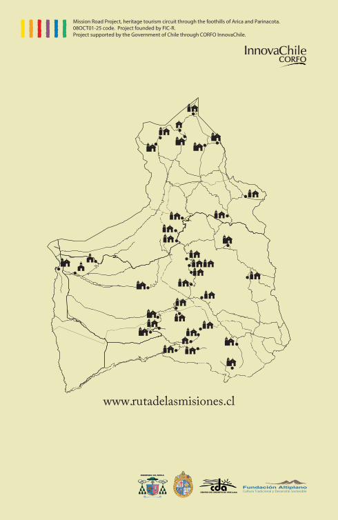
www.rutadelasmisiones.cl
Mission Road Project, heritage tourism circuit through the foothills of Arica and Parinacota. 08OCT01-25 code. Project founded by FIC-R.Project supported by the Government of Chile through CORFO InnovaChile.