towards ecosystem conservation and sustainable artisanal ... file2 this document was produced with...
TRANSCRIPT

1
Towards Ecosystem Conservation and Sustainable
Artisanal Fisheries in the Mediterranean basin
WP4: Characterization of the study area
Introduction to study areas ports and
fleets
June 2014

2
This document was produced with the financial assistance of the European Union under the ENPI CBC Mediterranean Sea Basin Programme. The contents of this document are the sole responsibility of the Institute or Marine Sciences-CSIC, the University of Genoa and the National Institute of Marine Sciences and Technologies and can under no circumstances be regarded as reflecting the position of the European Union or of the Programme’s management structures.
The 2007-2013 ENPI CBC Mediterranean Sea Basin Programme is a multilateral Cross-Border Cooperation initiative funded by the European Neighbourhood and Partnership Instrument (ENPI). The Programme objective is to promote the sustainable and harmonious cooperation process at the Mediterranean Basin level by dealing with the common challenges and enhancing its endogenous potential. It finances cooperation projects as a contribution to the economic, social, environmental and cultural development of the Mediterranean region. The following 14 countries participate in the Programme: Cyprus, Egypt, France, Greece, Israel, Italy, Jordan, Lebanon, Malta, Palestine, Portugal, Spain, Syria (participation currently suspended), Tunisia. The Joint Managing Authority (JMA) is the Autonomous Region of Sardinia (Italy). Official Programme languages are Arabic, English and French (www.enpicbcmed.eu).
The European Union is made up of 28 Member States who have decided to gradually link together their know-how, resources and destinies. Together, during a period of enlargement of 50 years, they have built a zone of stability, democracy and sustainable development whilst maintaining cultural diversity, tolerance and individual freedoms. The European Union is committed to sharing its achievements and its values with countries and peoples beyond its borders.
Authors
Marzia Bo1, Adriana Profeta1, Sandro Cerasi1, Adel Gaamour2, Skander Ben Salem2, Sandra Mallol3, David Díaz Viñolas4
Institutions involved 1University of Genoa, 2 National Institute of Marine Sciences and Technologies, 3 Centre Oceanogràfic de les Balears- IEO, 4Institute of Marine Sciences-CSIC
3
Contents
Authors ................................................................................................................................................... 2
Institutions involved .............................................................................................................................. 2
Contents ................................................................................................................................................. 3
Introduction ............................................................................................................................................ 5
SPAIN……………………………………………………………………………………………………………..6
STUDY AREA 1. Canal de Menorca, Balearic Islands………………………….……………………...……6
1.- General characteristics of the area…………………………………….………………….……….………6
2.- Fleet and fishing tactics characterization………………………………………………………………….7
STUDY AREA 2. Cap de Creus, Catalonia…………………………………………………………….…..12
1.- General characteristics of the area…………………………………………………………...…………..12
2.- Fleet and fishing tactics characterization…………………………………………………………………13
ITALY…………………………………………………………………………………………………………....18
STUDY AREA 1. Pontine Archipelago, Lazio………………………………………………………….…….18
1.- General characteristics of the area…………………………………………………………………....….18
2.- Characteristics of the fleet…………………………………………………………………………………20
STUDY AREA 2. Gulf of Patti, Sicily……………………………………………………………………….25
1.- General characteristics of the area………………………………………………………………….……25
2.- Characteristics of the fleet…………………………………………………………………………………27
TUNISIA…………………………………………………………………………………………………….…...30
STUDY AREA 1. Region of Bizerte…………………………………………………………………………31
1.- Overview of the Bizerte region ………………………………………………..…………………………..31
2.- Artisanal Fleet and Fishing tactics in the region of Bizerte……………..………………………………35
STUDY AREA 2. Region of Nabeul…………………………………………………………………………38

4
1.- Overview of Nabeul region………………………………………………………………………..………38
2.- Artisanal Fleet and Fishing tactics in the region of Nabeul……………………………………….……41

5
Introduction
The field activities developed in the framework of ECOSAFIMED project seeks to
assess the impact of the artisanal fisheries in three different areas of the
Mediterranean Sea. Prior to these field work, which involves mainly onboard
observations and ROV surveys, a full characterization of the study areas was carried
out by project partners.
All the preliminary work has as result this report introducing ports and fleets of each
study area, which is based on interviews, bibliographic search and previous
experience of the scientists involved the project. Partners have agreed to present this
information all together in order to present a more complete vision of the action area
covered by ECOSAFIMED project and facilitate the comparison of similarities and
differences among study areas.
6
SPAIN
STUDY AREA 1. Canal de Menorca, Balearic Islands
1. General characteristics of the area
The area of Menorca Channel is a marine corridor of 36 km minimum wide, located
between the islands of Mallorca and Menorca, in the northeastern part of the
archipelago of the Balearic Islands. This area is one of the most important and
heterogeneous fishing grounds that exist in the Balearic Islands. The coastal shelf
between the two islands (just 100 m deep) is characterized by a high environmental
heterogeneity due to the occurrence of rocky bottoms, Posidonia oceanica meadows,
sandy shores, detrital and gravel bottoms and maërl beds. These grounds have been
well preserved due to the mainly developed artisanal fishing activity.
Artisanal boat of 8 meters fishing in the middle of the Minorca Channel. The Capdepera lighthouse marks the
most western part of the Majorca Island

7
2.- Fleet and fishing tactics characterization
There are two main fishing ports in Menorca Island (Ciutadella and Maó) and three
main ports in Mallorca Island (Pollença, Alcudia and Cala Rajada). Moreover, some
vessels from Alcudia and Cala Rajada docks in three secondary harbors (Cala Bona
depending from Cala Rajada harbor and, Colonia de Sant Pere and Can Picafort
depending from Alcudia harbor).
The information regarding the characterization of the fleet and fishing tactics was
gathered throughout questionnaires circulated around the skippers of artisanal
vessels in each study area. The surveys consisted in interviewing those about three
main aspects: 1) Dimension of the active artisanal fleet comprising technical
information about the vessels (number of boats, total length, tonnage (GT), engine
power (HP), year of construction, material used, technical devices, and crew
number); 2) Seasonal fishing pattern, establishing target species and main gears
used; and 3) Technical characteristics of gears employed for each fishing tactic or
métier.
A total of 72 interviews with the skippers from the Minorca’s Chanel area were done
representing 60% of the total active artisanal vessels.
A B
8
a- A traditional small boat in the Minorca Channel using a single roll machine to haul the trammel net. b –
Accumulative impact of benthic species using trammel net.
The main fishery, in terms of number of boats registered (87% of the fleet) was the
artisanal one. Trawlers (11% of the total number of boats) was composed by 16
vessels (4 in Cala Rajada, 4 in Alcudia, 4 in Ciutadella, 3 in Maó and 1 in Pollença
harbor), however, accounted for about 74% of the fleet total tonnage and 41% of total
fishing power in the area. Moreover, there are 2 surface long-line fishing boats in the
Alcudia harbor.
The artisanal fleet is made up by 120 boats involving 170 fishermen. Technical
characteristics of the artisanal fleet are summarized in Table 1. The average of the
technical features are 7.96 m total length (±1.45 S.D.), 2.57 t GT (±1.51 S.D.) and an
engine power of 48.3 HP (±30.2 S.D.).
The mean age of the vessels has been calculated referred to the year 2014, with a
result of about thirty years old averaged aged fleet. The majority of vessels are made
of fiberglass material (58% of mean of the total artisanal fleet).
HARBOUR Nº
BOATS TOTAL LENGTH
(m) HP GT MATERIAL AGE (years) CREW
(Mean ± SD) (Mean ± SD) (Mean ± SD) (main %) (Mean ± SD) (total nº)
CALA BONA 7 8.92 ± 1.47 70.0 ± 51.4 3.46 ± 1.62 57%
Fiberglass 22.8 ± 12.2 12
CALA RAJADA 12 8.81 ± 1.33 72.3 ± 39.7 3.81 ± 1.80 92%
Fiberglass 17.4 ± 7.7 21
COL. SANT PERE 4 8.68 ± 0.53 77.2 ± 35.3 3.73 ± 0.80
75% Fiberglass 10.0 ± 9.1 5
CAN PICAFORT 2 9.20 ± 0.08 36.0 ± 8.5 3.65 ± 0.84
100% Fiberglass 19.0 ± 5.6 4
ALCUDIA 23 8.47 ± 1.25 52.1 ± 22.3 3.05 ± 1.53 56%
Fiberglass 29.0 ± 17.8 37
POLLENÇA 18 8.05 ± 1.03 39.6 ± 12.5 2.33 ± 0.84 55% Wood 32.3 ± 19.5 24
CIUTADELLA 20 8.30 ± 1.26 55.8 ± 30.3 2.77 ± 1.65 55% Wood 34.7 ± 14.7 27

9
MAÓ 34 6.71 ± 1.26 30.3 ± 19.7 1.44 ± 0.80 62%
Fiberglass 36.9 ± 15.6 40
TOTAL 120 7.96 ± 1.45 48.3 ± 30.2 2.57 ± 1.51 58%
Fiberglass 30.4 ± 16.8 170
Table 1.- Summary of technical characteristics of artisanal fleet in Minorca Channel
Fishing tactics
A total of 24 different fishing tactics or métiers were identified with the corresponding
fishing period in the fishing area (Figure 1).
Month
Métier J F M A M J J A S O N D % fleet
Aphia minuta boat seine 21
Sepia officinalis trammel net 83
Solea solea gillnets 1
Thunnus thynnus gillnets 1
Mustelus mustelus gillnets 1
Zeus faber gillnets 1
Palinurus elephas trammel net 85
Rocky fish trammel net 30
Scorpaena scrofa trammel / gillnet 20
Mullus surmuletus trammel / gillnet 33
Coryphaena hippurus lampara net 25
Euthynnus alletteratus gillnets 1
Sparidae gillnets 1
Seriola dumerilii gillnets 1
Seriola dumerilii stationary pound net 2
Sarda sarda combined net 1
Epinephelus marginatus longline 17
Dentex and Pagrus longline 22
Diplodus sp. longline 1
Pagellus bogaraveo longline 1
Raja sp. longline 1
Squid jig handline 47
Serranidae handline 1Seriola dumerilii bottom troll line 1
Figure 1.- Chronogram with seasonal fishing activity and percentage of artisanal fleet practicing each
métier.
In the fishing area of Minorca’s Chanel the main fishing gears used by the coastal
fishery are trammel nets and in minor quantity gillnets. Trammel net is mainly used to
target cuttlefish (Sepia officinalis) in winter and early spring; spiny lobster (Palinurus
elephas) and red scorpionfish (Scorpaena scrofa) in summer. Gillnets are generally
10
employed to catch John dory (Zeus faber) in spring-summer, juveniles of greater
amberjack Seriola dumerilii in late summer and autumn and red mullet in autumn.
Bottom longlines are traditionally employed mainly to catch sparidae species (Dentex
dentex, Pagrus pagrus, Spondyliosoma cantharus, Pagellus erythrinus, Diplodus
sargus and Diplodus vulgaris) in autumn and winter, and groupers (Epinephelus sp.)
in summer-autumn, though used by few vessels all over the year, or as a fishing
method between seasons of main target species described before. Jigs for squids
are used also as a common complementary fishing method during winter and
summer.
Other gears, such as boat seine net for dolphinfish (Coryphaena hippurus) is used in
autumn only in Mallorca Island. The technical characteristics of the main gears
employed are detailed in Table 2.
11
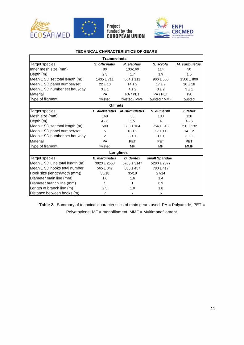
Trammelnets
Target species S. officinalis P. elephas S. scrofa M. surmuletus
Inner mesh size (mm) 80 133-160 114 50
Depth (m) 2.3 1.7 1.9 1.5
Mean ± SD set total length (m) 1435 ± 711 664 ± 111 906 ± 556 1500 ± 800
Mean ± SD panel number/set 22 ± 10 14 ± 2 17 ± 9 30 ± 16
Mean ± SD number set haul/day 3 ± 1 4 ± 2 3 ± 2 3 ± 1
Material PA PA / PET PA / PET PA
Type of filament twisted twisted / MMF twisted / MMF twisted
Target species E. alletteratus M. surmuletus S. dumerilii Z. faber
Mesh size (mm) 160 50 100 120
Depth (m) 4 - 6 1.5 4 4 - 6
Mean ± SD set total length (m) 500 880 ± 104 754 ± 516 750 ± 132
Mean ± SD panel number/set 5 18 ± 2 17 ± 11 14 ± 2
Mean ± SD number set haul/day 2 3 ± 1 3 ± 1 3 ± 1
Material PA PET PET PET
Type of filament twisted MF MF MMF
Target species E. marginatus D. dentex small Sparidae
Mean ± SD Line total length (m) 3923 ± 2558 5708 ± 3147 5280 ± 2877
Mean ± SD hooks total number 565 ± 347 838 ± 457 780 ± 417
Hook size (length/width (mm)) 35/18 35/18 27/14
Diameter main line (mm) 1.6 1.6 1.4
Diameter branch line (mm) 1 1 0.9
Length of branch line (m) 2.5 1.8 1.8
Distance between hooks (m) 7 7 6
TECHNICAL CHARACTERISTICS OF GEARS
Gillnets
Longlines
Table 2.- Summary of technical characteristics of main gears used. PA = Polyamide, PET =
Polyethylene; MF = monofilament, MMF = Multimonofilament.
12
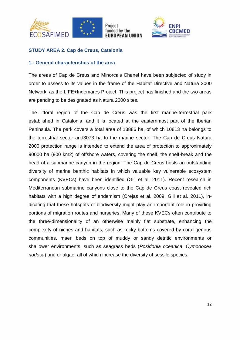
STUDY AREA 2. Cap de Creus, Catalonia
1.- General characteristics of the area
The areas of Cap de Creus and Minorca’s Chanel have been subjected of study in
order to assess to its values in the frame of the Habitat Directive and Natura 2000
Network, as the LIFE+Indemares Project. This project has finished and the two areas
are pending to be designated as Natura 2000 sites.
The littoral region of the Cap de Creus was the first marine-terrestrial park
established in Catalonia, and it is located at the easternmost part of the Iberian
Peninsula. The park covers a total area of 13886 ha, of which 10813 ha belongs to
the terrestrial sector and3073 ha to the marine sector. The Cap de Creus Natura
2000 protection range is intended to extend the area of protection to approximately
90000 ha (900 km2) of offshore waters, covering the shelf, the shelf-break and the
head of a submarine canyon in the region. The Cap de Creus hosts an outstanding
diversity of marine benthic habitats in which valuable key vulnerable ecosystem
components (KVECs) have been identified (Gili et al. 2011). Recent research in
Mediterranean submarine canyons close to the Cap de Creus coast revealed rich
habitats with a high degree of endemism (Orejas et al. 2009, Gili et al. 2011), in-
dicating that these hotspots of biodiversity might play an important role in providing
portions of migration routes and nurseries. Many of these KVECs often contribute to
the three-dimensionality of an otherwise mainly flat substrate, enhancing the
complexity of niches and habitats, such as rocky bottoms covered by coralligenous
communities, maërl beds on top of muddy or sandy detritic environments or
shallower environments, such as seagrass beds (Posidonia oceanica, Cymodocea
nodosa) and or algae, all of which increase the diversity of sessile species.

13
View of a small boat in the tiny harbor of Portlligat (Cadaqués), different métiers are used by the
fishermen in that harbout.
The presence of a submarine canyon in the area increases the ecological importance
of the entire region. Plankton and benthic communities in the canyon benefit from a
high concentration of particles as a consequence of strong current regimes (García et
al. 2008, Tesi et al. 2010), thus increasing the presence of fish, seabird and cetacean
species which use it as feeding ground (Gili et al. 2011, Würtz et al. 2012). Cold-
water corals provide habitat for juveniles and larvae of several fish species, some of
them with high commercial value, consequently acting as a refuge from fishing
pressure and allowing the recovery of depleted stocks (Freiwald and Roberts 2005).
Fleet Characterization
2.- Fleet and fishing tactics characterization
The study area Cap de Creus includes a protected area in 1998 by her regional
government of Catalonia (Generalitat de Catalunya) in order to protect and manage

14
natural resources. The Natural Park consists of both marine and terrestrial
environment protected areas of the park's total area is 13,905 ha, of which 10,813
are terrestrial and 3092 are marine.
In the marine protected area are regulated activity artisanal fishing and nautical
recreation. As far as the administrative side, there are four municipalities that cover
the entire park, the population of Roses, Cadaqués, Port de la Selva and Llançà. All
towns have ports that include artisanal fleet. This last resort only has a land area
protected.
Most of the artisanal fleet in the Cap de Creus is composed of vessels between 6 and
12 meters. Different types of gear used. The purse seine and trawl presents an
important activity in the area of Cap de Creus, but is not permitted within the area of
the reserve.
The number of artisanal fishermen fishing in the Cape Creus area including 4 port is
34 vessels, the total number of fishermen is 78, 45% of these usually fishing in the
area of the Natural Park. Vessels whose main harbor is Roses shows a high number
of metiers, as they may exploit the wide sandy bay and the Gulf of Roses, while the
other ports work mainly in rocky bottoms.
The information regarding the characterization of the fleet and fishing tactics was
gathered throughout questionnaires circulated around the skippers of artisanal
vessels in each study area. The surveys consisted in interviewing those about three
main aspects: 1) Dimension of the active artisanal fleet comprising technical
information about the vessels (number of boats, total length, tonnage (GT), engine
power (HP), year of construction, material used, technical devices, and crew
number); 2) Seasonal fishing pattern, establishing target species and main gears
used; and 3) Technical characteristics of gears employed for each fishing tactic or
métier (See Annex I).
A total of 23 interviews with the skippers from the Cap de Creus area were done
representing 67% of the total active artisanal vessels,

15
Fishing tactics
In the area of Cap de Creus the presence of trammel net is widespread and covers
the most part of the benthic fishing grounds from the Natural Park and adjacent areas
outside. This kind of fishing occasionally exploited at depths of 250 meters and the
farthest distance of the port does not exceed 7 nautical miles. The fleet of Cadaques
and Port de la Selva which departs further offshore to works with this type of gear.
The presence of trammel exceed 20% in each port, with the majority common fishing
zone. (Figure 2).
In the port of Llança the most important metier is the bottom longline, with more than
35% presence, followed by fishing gear basically different fish nets and some very
specific gear. In the area of Port de la Selva using Gillnets for different fish
(especially Sparus auratus, Pagellus acarne, Pagellus erythrinus). Use of Gillnets are
widely used in ports that have close an area of habitat is sandy, as is the port of
Roses or Port de la Selva.
The use of pots in every harbor shows the importance of the Octopus vulgaris
fishery, because this kind of métier could be used in combination of the other métiers
throughout the year.
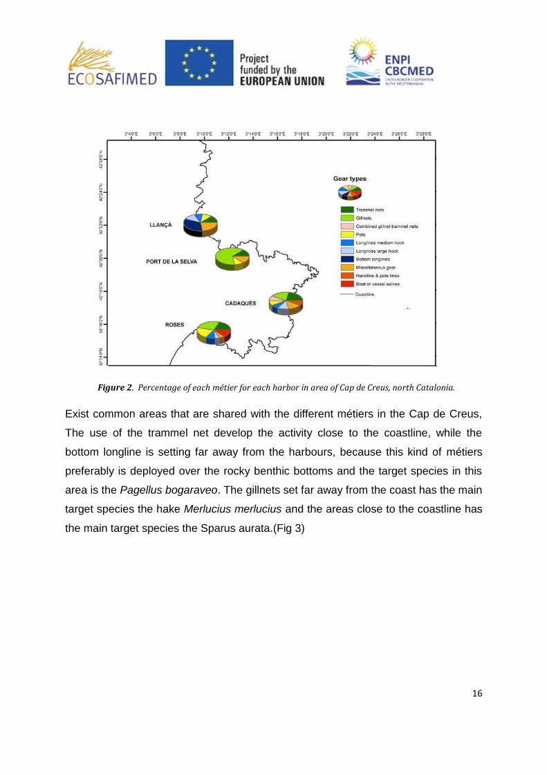
16
Figure 2. Percentage of each métier for each harbor in area of Cap de Creus, north Catalonia.
Exist common areas that are shared with the different métiers in the Cap de Creus,
The use of the trammel net develop the activity close to the coastline, while the
bottom longline is setting far away from the harbours, because this kind of métiers
preferably is deployed over the rocky benthic bottoms and the target species in this
area is the Pagellus bogaraveo. The gillnets set far away from the coast has the main
target species the hake Merlucius merlucius and the areas close to the coastline has
the main target species the Sparus aurata.(Fig 3)

17
Figure 3. Map of the main métiers (Surface longlines, Trammle nets, Bottom longlines,
Gillnets) using a 500m grid . Courtesy of Purroy et al, 201.
Fleet of the Llança Harbour in the north side ( Mar d’amunt) of the cap de Creus

18
ITALY
STUDY AREA 1. Pontine Archipelago, Lazio
1.- General characteristics of the area
The Pontine Archipelago is situated off the coast of Lazio, in the central Italy, and is
part of the administration of the Latina Province. The archipelago is situated in the
Central Tyrrhenian Sea extending between the North parallels 40°47’ and 40°59’ N
and the East meridians 12°50’ and 13°30’.
It comprehends two groups of islands quite distant from each others: the
northernmost group, 15 nm off the coasts of the Circeo Promontory, comprehends
the islands of Zannone, Gavi, Ponza and Palmarola. The second group of islands, at
about 20 nm South-East from the first one, comprehends the islands of Ventotene
and St. Stefano. These two islands are far more closer to the northern coasts of
Campania and Ischia island (NA) than to the Lazio coasts. Since 12th December
1997 they belong to the Marine Protected Area “Ventotene and St. Stefano Islands”
established by the Ministry for the Environment under the law GU n° 45 del
24.2.1998.
The field activities of ECOSAFIMED, both onboard fishing surveys and ROV surveys,
were conducted in the first group of islands, up to the Botte Shoal, at about 15 nm
from the islands of Ventotene and St. Stefano.
The entire Pontine Archipelago was formed after the distensive phase that interested
the Tyrrhenian area of the Apennines resulting in the characteristic tectonic structure.
On these fractures, heading NW to SE, developed the volcanisms which in the
Figure. 1 View of Ponza Island

19
inferior Pleistocene formed the islands. The Pontine islands form, together with the
large underwater basis from which they emerge, an important volcanic mass
separated into various structures; Ventotene and St. Stefano islands for example
represent the top of a single volcanic cone. Ponza (Fig. 1) represents the western
part of a large volcanic cone, where two residual craters are still visible in the Ponza
Bay and in the Inferno Bay. Palmarola represents the eastern part of a secondary
eruptive cone, as well as the Botte Shoal. The Zannone Island is the only one,
among all the Pontine islands, to be made by both volcanic rocks and metamorphic
and sedimentary rocks of about 200 million years.
The coastal morphology of the Pontine Islands is generally variously articulated along
the shores, with a series of bays and short beaches. The continental platform is
poorly extended in the entire archipelago, especially towards the open sea, where
200 m depth sea bottoms are found at few hundred meters from the coast.
From the meteorological point of view, the islands are subjected to the same wave
exposure for long period of times, especially to the wind forces of the III and IV
quadrants. These forces strongly lashes the islands, being not diminished by a large
continental platform. On the other hand, the waves produced by the wind forces of
the I and II quadrants, coming from the Italian coast, show a smaller fetch and a
lower intensity.
The Pontine Archipelago is interested by the mild northward Tyrrhenian current,
moving from SW to NE. The intensity of this current is very low, less than 1 knot/h
and therefore has no significative consequences on the sedimentary circulation.
Local currents of variable direction and occasional strong intensity are in any case
present.
The sea bottoms of the Pontine Archipelago are generally characterized by a steep
slope and by numerous outcropping rocks, therefore in general the biocoenoses are
those of hard bottoms, also at major depths. Along the natural beaches, formed
nearby the most steep promontories, the detritic bottom hosts typical soft bottom
biocoenoses. The islands are typically surrounded by a belt of Posidonia oceanica
meadows starting from 10 m depth up to 40-50 m.
Description of the harbors and maritime authorities
In the study area, the harbor activities are concentrated in the area overlooking the
village of Ponza, situated in the SE side of the island (Fig. 2). The harbor, built in a
natural bay, is formed by a dock (Molo Musco), protected by an artificial reef directed
parallel for about 30 m.
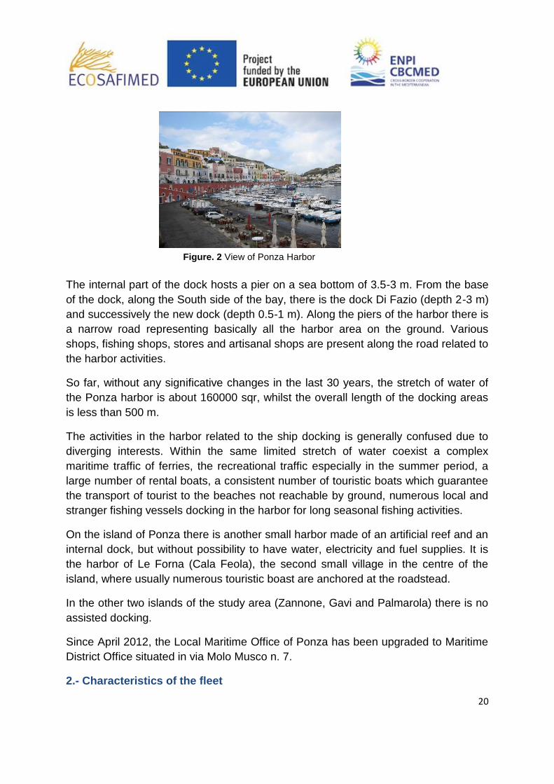
20
The internal part of the dock hosts a pier on a sea bottom of 3.5-3 m. From the base
of the dock, along the South side of the bay, there is the dock Di Fazio (depth 2-3 m)
and successively the new dock (depth 0.5-1 m). Along the piers of the harbor there is
a narrow road representing basically all the harbor area on the ground. Various
shops, fishing shops, stores and artisanal shops are present along the road related to
the harbor activities.
So far, without any significative changes in the last 30 years, the stretch of water of
the Ponza harbor is about 160000 sqr, whilst the overall length of the docking areas
is less than 500 m.
The activities in the harbor related to the ship docking is generally confused due to
diverging interests. Within the same limited stretch of water coexist a complex
maritime traffic of ferries, the recreational traffic especially in the summer period, a
large number of rental boats, a consistent number of touristic boats which guarantee
the transport of tourist to the beaches not reachable by ground, numerous local and
stranger fishing vessels docking in the harbor for long seasonal fishing activities.
On the island of Ponza there is another small harbor made of an artificial reef and an
internal dock, but without possibility to have water, electricity and fuel supplies. It is
the harbor of Le Forna (Cala Feola), the second small village in the centre of the
island, where usually numerous touristic boast are anchored at the roadstead.
In the other two islands of the study area (Zannone, Gavi and Palmarola) there is no
assisted docking.
Since April 2012, the Local Maritime Office of Ponza has been upgraded to Maritime
District Office situated in via Molo Musco n. 7.
2.- Characteristics of the fleet
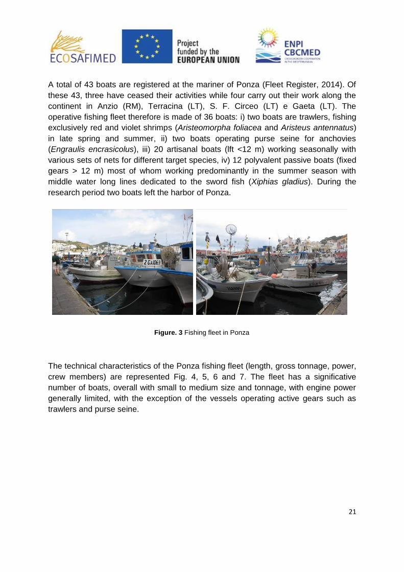
Figure. 2 View of Ponza Harbor
21
A total of 43 boats are registered at the mariner of Ponza (Fleet Register, 2014). Of
these 43, three have ceased their activities while four carry out their work along the
continent in Anzio (RM), Terracina (LT), S. F. Circeo (LT) e Gaeta (LT). The
operative fishing fleet therefore is made of 36 boats: i) two boats are trawlers, fishing
exclusively red and violet shrimps (Aristeomorpha foliacea and Aristeus antennatus)
in late spring and summer, ii) two boats operating purse seine for anchovies
(Engraulis encrasicolus), iii) 20 artisanal boats (lft <12 m) working seasonally with
various sets of nets for different target species, iv) 12 polyvalent passive boats (fixed
gears > 12 m) most of whom working predominantly in the summer season with
middle water long lines dedicated to the sword fish (Xiphias gladius). During the
research period two boats left the harbor of Ponza.
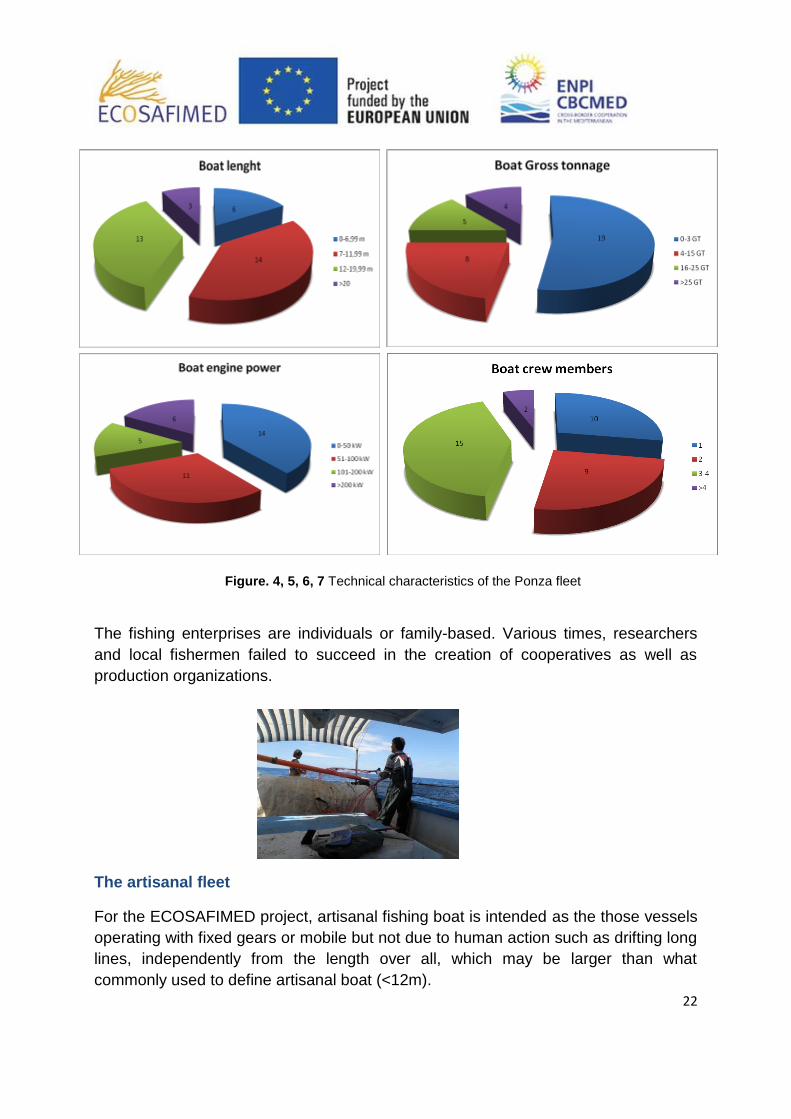
The technical characteristics of the Ponza fishing fleet (length, gross tonnage, power,
crew members) are represented Fig. 4, 5, 6 and 7. The fleet has a significative
number of boats, overall with small to medium size and tonnage, with engine power
generally limited, with the exception of the vessels operating active gears such as
trawlers and purse seine.
Figure. 3 Fishing fleet in Ponza
22
The fishing enterprises are individuals or family-based. Various times, researchers
and local fishermen failed to succeed in the creation of cooperatives as well as
production organizations.
The artisanal fleet
For the ECOSAFIMED project, artisanal fishing boat is intended as the those vessels
operating with fixed gears or mobile but not due to human action such as drifting long
lines, independently from the length over all, which may be larger than what
commonly used to define artisanal boat (<12m).
Figure. 4, 5, 6, 7 Technical characteristics of the Ponza fleet

23
With respect to the 32 boats respecting these criteria, 12 interviews were carried out
to the captains of the vessels with the aim of identifying a representative sub-sample
of data to depict the artisanal fishing reality of the island. Some fishermen did not
collaborated while others were not contactable, however 12 was sufficient to draw a
good picture of the fleet. The interviews were focused on gathering more details on
some technical and social aspects of the artisanal fishing activities, such as typology
and characteristics of the gears, seasonality, fishing grounds, crews, features of the
vessels (Fig. 8).
Of the 32 artisanal fishing boats operating with fixed gears, four fish cod with gillnets
for the entire year, while other four alternate this activity, carried out in winter and
spring, with the sword fish long line fishing in late spring and summer. There are also
15 boats operating two distinct gears: trammel nets for lobsters from 1st of April to
31st of August and gillnets for cuttlefish and rocky bottom fish on shallow bottoms (0-
100m depth). Of these latter boats, the majority does not work in the winter period
(1st of January to 31st of March) due to the limited size and power of the vessels that
does not allow safe operations in unstable climatic conditions. Four other vessels
carry out exclusively the sword fish fishing with long lines closing the activity during
the legislative stop, one boat works all the year round with cods fished with long lines,
three boats operate gillnets for cuttlefish and rocky bottom fish on shallow bottoms
(0-100m depth), while one boat is dedicated to the fishing of Spicara smaris during
the reproductive period from April to May or in the dispersal period, from September
to November.
The characteristics of the gears may vary also within the same fishing activity
focused on the catch of a specific target. In the case of cod, for example, even if all
vessels operate with gillnets monofilament in nylon, there are some distinctions
relatively to the length of the gears, going from 3000 to 5000 m depending on the
size of the boat, the number of crew members, the size and diameter of the filament
of the mesh. In this sense, while in the summer period all the boats operate cod
fishing using 4.2m tall nets, mesh 50-56mm and monofilament diameter 0.25-
0.28mm, in winter time some boats (usually 4/8) use larger nets (5.5 tall, 80 mm
mesh, diameter 0.35mm), and the remaining use the summer asset.
For what concern the lobster trammel nets, the technical characteristics of this gear is
basically the same for all the boats. They use heavy trammel nets (filament 210/12, in
other cases 210/9, 210/16) with an inner mesh size of 100mm and a height of 1.2-
1.5m. The length of this gear is limited (500-750m) due to the fact they are used to
surround outcropping rocks situated in the mud or coralligenous platforms. Usually
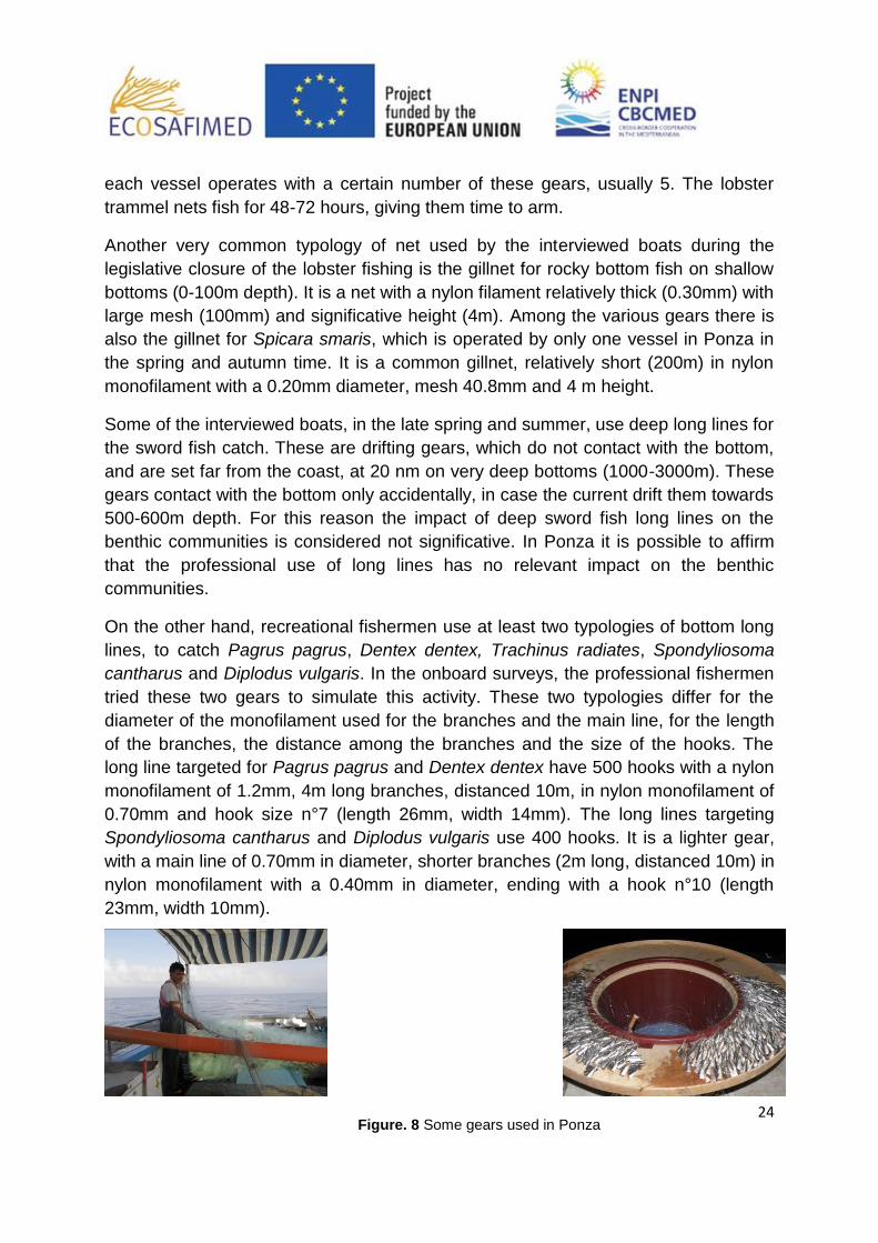
24
each vessel operates with a certain number of these gears, usually 5. The lobster
trammel nets fish for 48-72 hours, giving them time to arm.
Another very common typology of net used by the interviewed boats during the
legislative closure of the lobster fishing is the gillnet for rocky bottom fish on shallow
bottoms (0-100m depth). It is a net with a nylon filament relatively thick (0.30mm) with
large mesh (100mm) and significative height (4m). Among the various gears there is
also the gillnet for Spicara smaris, which is operated by only one vessel in Ponza in
the spring and autumn time. It is a common gillnet, relatively short (200m) in nylon
monofilament with a 0.20mm diameter, mesh 40.8mm and 4 m height.
Some of the interviewed boats, in the late spring and summer, use deep long lines for
the sword fish catch. These are drifting gears, which do not contact with the bottom,
and are set far from the coast, at 20 nm on very deep bottoms (1000-3000m). These
gears contact with the bottom only accidentally, in case the current drift them towards
500-600m depth. For this reason the impact of deep sword fish long lines on the
benthic communities is considered not significative. In Ponza it is possible to affirm
that the professional use of long lines has no relevant impact on the benthic
communities.
On the other hand, recreational fishermen use at least two typologies of bottom long
lines, to catch Pagrus pagrus, Dentex dentex, Trachinus radiates, Spondyliosoma
cantharus and Diplodus vulgaris. In the onboard surveys, the professional fishermen
tried these two gears to simulate this activity. These two typologies differ for the
diameter of the monofilament used for the branches and the main line, for the length
of the branches, the distance among the branches and the size of the hooks. The
long line targeted for Pagrus pagrus and Dentex dentex have 500 hooks with a nylon
monofilament of 1.2mm, 4m long branches, distanced 10m, in nylon monofilament of
0.70mm and hook size n°7 (length 26mm, width 14mm). The long lines targeting
Spondyliosoma cantharus and Diplodus vulgaris use 400 hooks. It is a lighter gear,
with a main line of 0.70mm in diameter, shorter branches (2m long, distanced 10m) in
nylon monofilament with a 0.40mm in diameter, ending with a hook n°10 (length
23mm, width 10mm).
Figure. 8 Some gears used in Ponza

25
STUDY AREA 2. Gulf of Patti, Sicily
1.- General characteristics of the area
The Gulf of Patti extends from Cape Calavà to Cape Milazzo, for an extension of 60
km of coastline. The area is characterized by several rocky promontories, like Cape
Lo Schino, Capo Calavà, Cape Tindari and Cape Milazzo, alternating with beaches
and sandy coasts (Fig. 1). Under Cape Tindari these beaches form an interesting
system of dunes with brackish lakes (lakes of Marinello) covering an area of about
400 hectares and declared a natural reserve (Decree No. 745/44 of the Sicilian
Region). This area forms a small bay that seems to be an important nursery area for
many fish.
The seabed of the Gulf of Patti is mostly sandy or muddy, with large Posidonia
oceanica meadows and, in some areas, of Cymodocea nodosa, which alternate
shoals and rocky bottoms, particularly near the cliffs overlooking the sea, such as
Cape Calavà and Capo Milazzo. Other areas with rocky bottom and important
benthic biological communities are the "Patti shoal", a big rock that come from a
depth of about 50 m in front of the town of Patti Marina, and Tindari shoal, at Cape
Tindari. The continental shelf in this area is very narrow and high depths are reached
very quickly.
Description of the harbors and maritime authorities
There is an uneven harbour system in the gulf area and several deficiencies in
infrastructure, because the fishing boats are scattered along the coast, in the ports
situated along the sandy shores. Although in the area there are two major ports,
Milazzo and Portorosa, they are not fishing ports. Milazzo harbour is an important
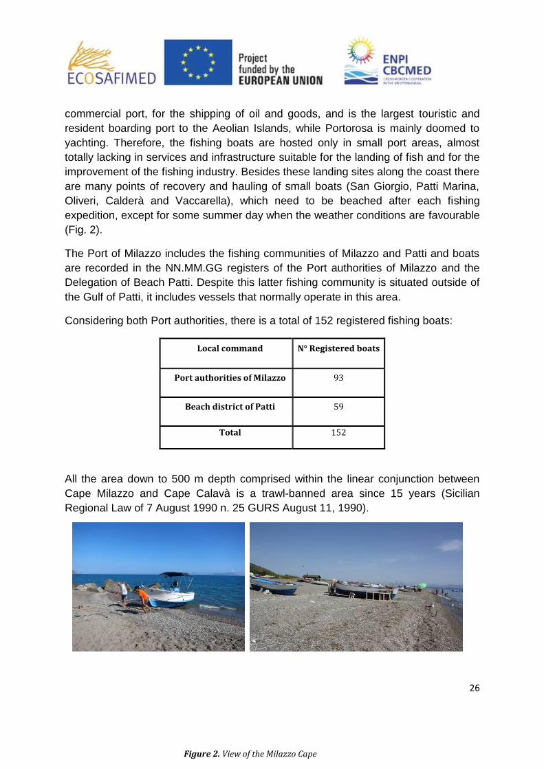
Figure. 1 View of the Milazzo Cape
26
commercial port, for the shipping of oil and goods, and is the largest touristic and
resident boarding port to the Aeolian Islands, while Portorosa is mainly doomed to
yachting. Therefore, the fishing boats are hosted only in small port areas, almost
totally lacking in services and infrastructure suitable for the landing of fish and for the
improvement of the fishing industry. Besides these landing sites along the coast there
are many points of recovery and hauling of small boats (San Giorgio, Patti Marina,
Oliveri, Calderà and Vaccarella), which need to be beached after each fishing
expedition, except for some summer day when the weather conditions are favourable
(Fig. 2).
The Port of Milazzo includes the fishing communities of Milazzo and Patti and boats
are recorded in the NN.MM.GG registers of the Port authorities of Milazzo and the
Delegation of Beach Patti. Despite this latter fishing community is situated outside of
the Gulf of Patti, it includes vessels that normally operate in this area.
Considering both Port authorities, there is a total of 152 registered fishing boats:
Local command N° Registered boats
Port authorities of Milazzo 93
Beach district of Patti 59
Total 152
All the area down to 500 m depth comprised within the linear conjunction between
Cape Milazzo and Cape Calavà is a trawl-banned area since 15 years (Sicilian
Regional Law of 7 August 1990 n. 25 GURS August 11, 1990).
Figure 2. View of the Milazzo Cape

27
2.- Characteristics of the fleet
The fleet of the Gulf is distinctly artisanal and is divided into demersal and pelagic
fishery (for small, medium and large pelagic species). A high percentage of vessels
has a length overall under 12 m considered as the limit for artisanal boats. The mean
length of 152 vessels registered is 7.8 m of length overall, with mean values of
tonnage and engine power respectively of 4.4 tonnes (Gross Tonnage) and 54.5 kW
(Fig. 3).
In the following table there is a summary of the technical characteristics of the boats
below the authorities of Milazzo and Patti:
Local
command
Boats
registered
<12 m Length
overall <10 Gross Tonnage <20 kW
N % N % N
Port
authorities
of Milazzo
93 82 88,2 81 87,1 61 65,6
Beach
district of
Patti
59
52 88,1 55 93,2 45 76,3
Total 152 134 88,5 136 83,9 106 65,4
Given the strong adaptability and strong seasonality between the different types of
fisheries, it is not possible to classify vessels based on fishing methods. Particularly
common among boats are the licenses to use longlines (93.5%) and gillnets (88.2%),
while the number of licenses for seiners is lower (60.2%).
Figure 3. Artisanal boats in Patti
28
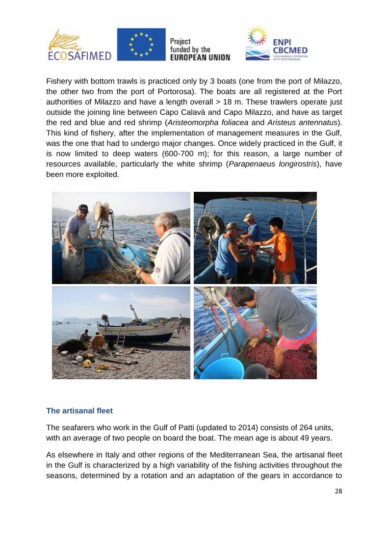
Fishery with bottom trawls is practiced only by 3 boats (one from the port of Milazzo,
the other two from the port of Portorosa). The boats are all registered at the Port
authorities of Milazzo and have a length overall > 18 m. These trawlers operate just
outside the joining line between Capo Calavà and Capo Milazzo, and have as target
the red and blue and red shrimp (Aristeomorpha foliacea and Aristeus antennatus).
This kind of fishery, after the implementation of management measures in the Gulf,
was the one that had to undergo major changes. Once widely practiced in the Gulf, it
is now limited to deep waters (600-700 m); for this reason, a large number of
resources available, particularly the white shrimp (Parapenaeus longirostris), have
been more exploited.
The artisanal fleet
The seafarers who work in the Gulf of Patti (updated to 2014) consists of 264 units,
with an average of two people on board the boat. The mean age is about 49 years.
As elsewhere in Italy and other regions of the Mediterranean Sea, the artisanal fleet
in the Gulf is characterized by a high variability of the fishing activities throughout the
seasons, determined by a rotation and an adaptation of the gears in accordance to

29
the presence of certain target species (Fig. 4). Fishing expeditions also are short and
rarely last more than 24 hours. The most commonly used fishing gear is the long-line,
particularly the deep one, specific to fish hake and white hake (Merluccius merluccius
and Phycis blennoides) even if, in recent years, this fishing gear is also used for
fishing silver scabbard fish (Lepidopus caudatus), which happens to be an abundant
resource and is turning into an important resource for the local market. This fishing
activity is practiced mainly during the winter months. Small driftnets (ferrettare) are
used in the autumn and winter months to catch smaller species of pelagic fish (Auxis
thazard thazard and Euthynnus alletteratus ). Another typically seasonal fishing
activity, practiced in autumn, is the purse seine practiced with the help of floating
palm fronds (Fish Aggregating Devices - FADs) which has, as target species,
dolphinfish (Coryphaena hippurus). In the summer months, the purse seine, is
practiced with a light source to catch small pelagic fish (anchovies and sardines).
Once, this fishery, was widespread. Today, the strong decrease in stocks of small
pelagic and high management costs, have compromised this activity. In the summer
period is practiced also the large pelagic fishery (swordfish and albacore) with
surface longliners and squid fishery with lines.
The harbour areas of the gulf are almost completely without services and
infrastructures suitable for landing fish or for improving the fishing industry. The sale
of fish is made in retail, often directly on the beach, after the boat is beached at the
end of the fishing expeditions (Fig. 5).
There are no data, or references, on recreational fisheries, that, however, is strongly
present and practiced within the Gulf. This kind of fishery is a serious threat to the
protection of the resource, given lack of strict controls and frequent dangerous
conflicts with professional fishermen.
Figure. 4 Artisanal fishermen working in the
Gulf
Figure. 5 Sale of fish on the beach
30
TUNISIA
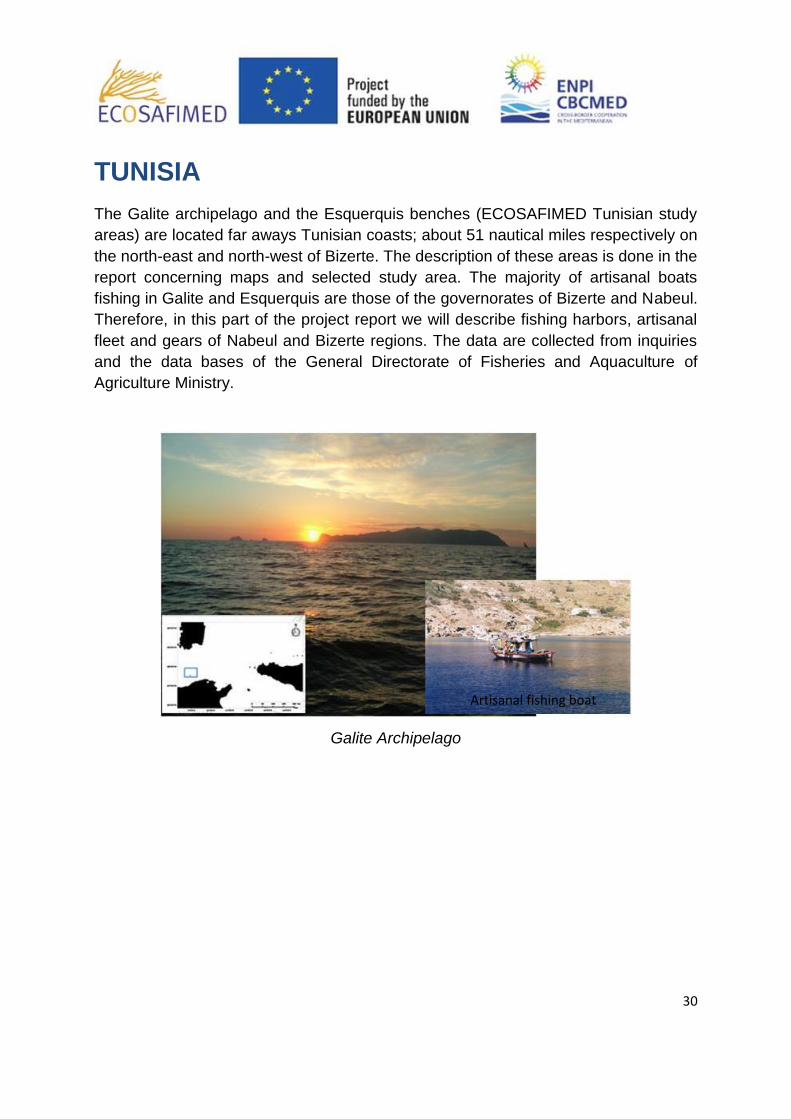
The Galite archipelago and the Esquerquis benches (ECOSAFIMED Tunisian study
areas) are located far aways Tunisian coasts; about 51 nautical miles respectively on
the north-east and north-west of Bizerte. The description of these areas is done in the
report concerning maps and selected study area. The majority of artisanal boats
fishing in Galite and Esquerquis are those of the governorates of Bizerte and Nabeul.
Therefore, in this part of the project report we will describe fishing harbors, artisanal
fleet and gears of Nabeul and Bizerte regions. The data are collected from inquiries
and the data bases of the General Directorate of Fisheries and Aquaculture of
Agriculture Ministry.
Galite Archipelago
Artisanal fishing boat

31
Esquerquis banks
STUDY AREA 1. Region of Bizerte
1 Overview of the Bizerte region
The region of Bizerte is located in the extreme north of the country, it is a very
important opening on the Mediterranean sea and the maritime lanes of the Strait of
Sicily which gives it a strategic position.
The Bizerte region enjoys a unique ecological setting combining the sea (200 km
coastline), the mountain and the forest. It is distinguished by the natural park of
Ichkeul listed as World Cultural and Natural Heritage of UNESCO.
The fisheries of Bizerte region are exploited by different operating modes namely
artisanal fishing, benthic trawling, purse seine and lagoon fishing. This part of Tunisia
is also distinguished in some fishing practices targeting especially spiny lobster and
red coral.
It is also at the port of Bizerte that the first experience of north-south partnership was
created as part of joint ventures in trawl fishing, purse seine fishing and long line
fishing (1999).
Port infrastructure:
The Bizerte region has a complete port infrastructure which include one (1) deep-sea
port and four (4) coastal ports (Table 1). These ports are:
The deep-sea port of Bizerte is located near the city of "Zarzouna" in
proximity of the east jetty of the commercial por. The construction of the fishing port
of Bizerte was completed in 1985. It is a deep-sea fishing port which has important

32
links with processing units of marine products and exporters mainly in partnership
with Europe.
The coastal port of Sidi Mechreg is located in a small cove about 1.5 km to
the east of the locality of Sidi Mechreg between Cap Negro and Cap Serrat. This
cove is open to the North West, and thereby greatly exposed to dangerous swells.
The port of Sidi Mechreg has been realized in 1997 with the aim to fix the maritime
population on the site, improve the conditions for the exercise of their activity,
increase their income and to develop the artisanal fishing activity.
The coastal port of Menzel Abderrahmane is located inside the Bizerte
lagoon. It has been constructed in 1995 with the aim to fix the maritime population of
the lagoon of Bizerte in their cities.
The coastal port of Cape Zebib occupies the bottom of a small cove near the
cape at its eastern side. It has been accomplished in 1997.
The coastal port of Ghar Melh is located in the north-west of the Gulf of
Tunis. It was built in 1975 along the shoreline resulting from the contributions of the
Greatest tunisian river "Oued Medjerda". It has recently undergone rehabilitation and
extension works.
Importance of artisanal fishing in the Bizerte region:
The Bizerte region hosts a fleet of 1535 fishing vessels whose 1472 artisanal
vessels, 20 trawlers and 43 seiners (Table 1). The motorization rate of the artisanal
fleet is around 43%. The active maritime population in artisanal fisheries was around
4253 individuals in 2011.
In the Bizerte region artisanal fishing activity is present in all the ports with varying
importance from one port to another. This importance could be seen through the
following points:
The artisanal units are more concentrated in the port of Bizerte with a
percentage of 51% of the total fleet followed by the port of Ghar Melh (18%) and the
port of Menzel Abderahmen (15%);
As consequence of this concentration of artisanal fleet the production of the
port of Bizerte is the largest both in weight and value followed by the port of Cape
Zebib;
The artisanal fleet of the port of Menzel Abderahmen holds the highest unit
price of products of the artisanal fishing activity (11,6 DT / kg) followed by the port of
Bizerte with 10,1 DT / Kg. The lowest values are recorded in the ports of Ghar Melh
(4,5 DT / Kg) and Cape Zebib (5,7 DT / Kg) where landings of the artisanal boats is

33
composed mainly by small pelagic species and mendole (Spicara maena ) with low
commercial value;
For the comparison by port we note that in relative terms, artisanal fishing is
exclusively engaged in the ports of Sidi Mechreg Menzel Abderahmen and Cape
Zebib. While in the ports of Ghar Melh and Bizerte, artisanal fishing activity is not a
big part of the total fisheries production due to the existence of highly developed
purse seine fishing and trawl fishing respectively in the ports of Bizerte and Ghar
Melh.
Finally, we note that the active artisanal fleet in the study areas of
ECOSAFIMED project is attached to the port of Bizerte. The units of the port of Sidi
Mechreg and Cap Zebib are small and do not fish away from their home sites. While
those of the port of Menzel Abderahmen are only active in the Bizerte lagoon and
never go out in the open sea. For artisanal boats from the port of Ghar Melh, they
practice mainly lagoon fishing in the lagoon of Ghar Melh and the rest go fishing in
the shallows close to the port and rarely fish in the ECOSAFIMED project study
areas.

34
Table 1. Infrastructures, superstructures artisanal fishing activity in the ports of Bizerte region
Ports
Deep-Sea Coastal
Bizerte Sidi Mechreg Menzel abderahmen Cap Zebib Ghar Melh
Docks (m) 1035 340 126 263 460
Halls (Number) 1 1 1
Wholesale market (Number) 1 1 1 1 1
Repair Shops (Nb (Surface)) 24 (1500m2) 1 (50 m2) 1 (80 m2) 1 (150 m2)
Dry up equipment (capacity in Tons) 110 15 15 15
Shipyard (Number) 7 2
Local fishermen (Nb (Surface)) 89 20 (142 m2) 10 (112 m2) 2 (60 m2)
Social purpose premises (Yes / No) Yes Yes Yes Yes
Ice plant (Tons / day) 42 2,5 10 20
Ice silos (Tons) 70 15 20 16
Cold chambers (Tons) 70 5 8 47
Freezing chambers (Tons) 250 1,5
Freezing tunnels (Tons / day) 32
Number of trawlers 20
Number of purse seiners 16 27
Artisanal fleet (attached to the port) Motorised 239 26 76 42 129
Non Motorised 182 48 148 32 134
Artisanal fleet (close Sites) Motorised 107 18
Non Motorised 230 61
Production by weight (tons) Artisanal fishery 603 60 44 322 278
% (Artisanal/Total) 17% 100% 100% 100% 14%
Production value (Thousand DT) Artisanal fishery 6116,4 413 509 1838 1260
% (Artisanal/Total) 28% 100% 100% 100% 18%
Average price (DT/Kg) 10,1 6,9 11,6 5,7 4,5

2 Artisanal Fleet and Fishing tactics in the region of Bizerte
The artisanal fleet, fishing in Galite and Esquerquis areas, is composed
by 112 boats involving 565 fishermen; about 67% of this fleet has Bizerte as
homeport. Technical characteristics of this fleet are summarized in Table 2. The
average of the technical features are 13.48 m total length (±2.53 S.D.), 18.2 t
GT (±9.22 S.D.) and an engine power of 176 HP (±96.7 S.D.). Additionally, the
quasi-totality of artisanal boats is made of wood material. We note that the fleet
of Sidi Mechreg harbor has limited characteristics allowing them to work
frequently near the coast of Bizerte.
Table 2. Technical characteristics of the artisanal fleet of Bizerte region
A total of 14 different fishing tactics or métiers were identified in the
region of Bizerte with the corresponding fishing period in the fishing area
(Figure 1). We note that these métiers are practiced in the two study areas of La
Galite and Banc of Esquerquis.
Species/Gear (Métiers) Jan Feb Mar Apr May Jun Jul Aug Sep Oct Nov Dec % fleet
Coryphaena hippurus / Seine 11%
Einephelus sp. / Longline 5%
Little sparidae / Longline 16%
Mullus sp. / Gillnet 32%
Pagrus pagrus & Dentex dentex & Scorpaena scrofa / Longline 53%
Palinurus elephas / trammelnet 84%
Polyprion americanus / Longline 11%
Sarda sarda / Gillnet 32%
Scorpaena scrofa / Trammelnet 42%
Sepia officinalis / Trammelnet 11%
Spondiliosoma cantharis / Traps 11%
Various fish / Gillnet 11%
Various fish / Trammelnet 42%
Xiphias gladius / Longline 16%
Months
Figure 1. Chronogram with seasonal fishing activity and percentage of artisanal fleet practicing
each métier in the region of Bizerte.
In the region of Bizerte the main fishing gears used by the coastal fishery are
trammel nets followed by longlines and by gillnets. Trammel net is mainly used
Harbour Number Total Length
(m)(Mean±SD)
HP
(Mean±SD)
GT (tonnes)
(Mean±SD)
Total Crew
Number
Bizerte 75 13.45±2.77 165.35±102.99 17.77±10.56 365
Cap Zbib 2 16.47±0.767 375.00±106.10 25.88±1.59 12
Ghar el Melh 32 13.76±1.42 201.00±51.10 19.87±3.93 181
Sidi Mechreg 3 9.54±0.059 59.67±14.500 6.60±0.71 7
Total 112 13.48±2.53 176.00±96.70 18.20±9.22 565
36
to target spiny lobster (Palinurus elephas) in spring and summer, red
scorpionfish (Scorpaena scrofa) in spring and summer, various fish (mullus sp.,
little sparidae, etc.) also in spring and summer and finally the cuttlefish (Sepia
officinalis) in spring and early summer. The second métier in terms of % of fleet
practicing it in the region of Bizerte is longlines targeting the red porgy (Pagrus
pagrus), the Commun dentex (Dentex dentex) and the red scorpionfish
(Scorpaena scrofa) all year round. Another type of métier which is specific for
the region of Bizerte is longlines targeting the Polyprion americanus all year
round. For the Gillnets there are two types generally employed to catch Mullets
(Mullus sp.) From January to September and Bonito (Sarda sarda) in autumn,
winter and spring.
With minor importance we find some métiers such as longlines targeting little
sparidae and various species of grouper (Epeniphelus sp.) with predominance
of speckled grouper (Epeniphelus marginatus) all year round and traps targeting
the black sea bream (Spondyliosoma cantharus) in winter-spring. Among all the
northern region of Tunisia; the last métier is encountred only in the port of
Bizerte.
We note that the new métier boat seine net for dolphinfish (Coryphaena
hippurus) is practiced since 2010 in the region of Bizerte and it is used from
September to December.
The technical characteristics of the main gears employed in the region of
Bizerte are detailed in Table 3 below.
37
Target species Mullus sp. Sarda sarda Spicara maena Various fish
Mean of Inner mesh size 54 82 56 64
Min of Inner mesh size 52 70 56 52
Max of Inner mesh size 60 90 56 70
Mean ± SD of Depth of the net (m) 2,8 ± 0,8 9 ± 4,8 1,5 ± 0 1,2 ± 0,1
Mean ± SD of Set total length (m) 1203 ± 406 3150 ± 1401 1400± 650 ± 87
Mean ± SD of panel number /set 21 ± 7,0 70 ± 32,6 40 ± 0 15 ± 0
Mean ± SD of number set haul/day 3,3 ± 2,1 1,7 ± 0,5 1,0 ± 0 2,7 ± 1,2
Material PET PET PET PET/PA
Type of filament MF MF MF MF/MMF
Target species Dentex dentex Mullus sp. Palinurus Elephas Scorpaena Scrofa Sepia officinalis Various fish
Mean of Inner mesh size 70 48 138 70 67 64
Min of Inner mesh size 70 48 80 60 60 52
Max of Inner mesh size 70 48 160 80 70 70
Mean ± SD of Depth of the net (m) 1,2 ± 0,05 1,5 ± 0,05 1,7 ± 0,8 1,3 ± 0,9 1,6 ± 0,2 1,7 ± 0,6
Mean ± SD of Set total length (m) 750 ± 0 1250 ± 0 603 ± 138 554 ± 213 850 ± 132 600 ± 122
Mean ± SD of panel number /set 15 ± 0 25 ± 0 13 ± 3,0 14 ± 4,6 16 ± 3,2 14± 1,6
Mean ± SD of number set haul/day 2 ± 0 2 ± 0 7,4 ± 2,1 4 ± 1,7 3,7 ± 2,3 3,6 ± 2,7
Material PA PET PA PA PET+/PA PA+/PET
Type of filament Twisted/MMF MF Twisted/MMF Twisted/MMF MF/MMF MMF/MF
Target species Epinephelus sp. Little sparidae Pagrus pagrus & Dentex Polyprion americanus Xiphias gladius
dentex & Scorpaena scrofa
Mean ± SD of Lengh of main line (m) 850 ± 71 767 ± 404 1084 ± 453 1400 ± 566 10875 ± 16126
Mean ± SD of Diameter of main line (mm) 3 ± 0 1,8 ± 0,3 2,4 ± 0,4 7,5 ± 0,7 1,6 ± 0,3
Mean ± SD of Lengh of branch line (m) 1,0 ± 0 1,3 ± 0,7 1,0 ± 0,1 1,1 ± 0,1 5,4 ± 2
Mean ± SD of Diameter of branch line (mm) 1,2 ± 0 0,9 ± 0,3 0,8 ± 0,1 2,2 ± 1,1 1,4 ± 0,4
Mean ± SD of Hook number 225 ± 106 285 ± 0 295 ± 145 185 ± 92 420 ± 333
Hook size 4-5 10-11-12 10-11 3-4 3-4-5
Average Distance between branches or hooks (m) 4,8 2,7 3,8 6,9 25,8
Longlines
TECHNICAL CHARACTERISTICS OF GEARS IN THE REGION OF BIZERTE
Trammelnets
Gillnets
Table 3. Summary of technical characteristics of main gears used. PA = Polyamide, PET =
Polyethylene; MF = monofilament, MMF = Multimonofilament. +
Mainly used Material
The most striking fact is that some fishermen in the region de Bizerte tend to
replace the intermediate net of trammelnets targetting Mullets (Mullus sp.), the
cuttle fish (Sepia officinalis) and little sparidae by a polyethylene monofilament
nets instead of polyamide multifilament nets.

38
Artisanal fishing boat in Bizerte port
STUDY AREA 2. Region of Nabeul
1. Overview of Nabeul region
The Nabeul region is located in the north east of Tunisia and covers 2822 km²
representing 1,8% of the total area of the country. It is characterized by an
important strategic location with 300km of coastline representing 20% of the
total Tunisian coastline in that it forms a peninsula opening the Sicily Channel
with Sicily island and closes the Gulf of Tunis.
The Nabeul region and in particular the zone of Kelibia has always strong
traditions related to fishing activities particularly small pelagic fishing activity
using purse seines. The seine or lamparo commonly called "diablo" made its
first appearance in the region during the period 1948-1949.
Port infrastructure:
The Nabeul region has a complete port infrastructure which includes one (1)
deep-sea port and four (4) coastal ports (Table 4). These ports are:
The deep-sea port of Kelibia, built in 1964, is installed on the
Eastern facade of the Cape Bon in a mountainous coastal area that has
a steep-terrain north of the city and lowlands where sandy beaches are
spread more or less developed sometimes lined with sand dunes and
39
sebkhas. It should be noted that it advances in sea about 400 m in the
SW of a rocky point (Cape Mostefa)
The coastal port of Sidi Daoud is located on the western coast
of the peninsula of Cape Bon. It is located to the north of a bay about 2
km wide and 1,3 km deep. Its construction was completed in 1983
The coastal port of Haouaria is located on the eastern facade of
the Cape Bon peninsula, south of Ras Addrag, it is about 4 km from the
city with the same name in the right of a popular beach frequented by
fishermen and vacationers. Protection work recently completed this year
since the port had problems with silting and accumulation of algae.
The coastal port of Beni Khiar was built since 1984. It has been
the object of protection works against silting and agitation in 1998. This
port opens on the Gulf of Hammamet and the fleet which is attached to it
does not fish in the ECOSAFIMED project study areas.
The region also contains two little sites hosting non motorized
artisanal boats: Hammamet Slimen.
Importance of artisanal fishing in the region of Nabeul
The fishing fleet of the Nabeul region accounts for 446 fishing units including
368 artisanal vessels, 19 trawlers and 59 purse seiners (Table 4). The
motorization rate of the artisanal fleet is relatively higher than that of Bizerte
region with 73% of artisanal units equipped with engines. The active maritime
population in artisanal fisheries was around 1833 individuals in 2011
In the region of Nabeul artisanal fishing activity is present in all the ports with
varying importance from one port to another. This importance could be seen
through the following points:
The artisanal units are more concentrated in the ports of Beni Khiar and Sidi
Daoud with respective percentages of 35% and 34% of the total number.
They are followed by the port of Kelibia (23%) and the port of Haouaria (8%
);
The production of artisanal fishing activity in the port of Sidi Daoud is the
largest compared to other ports both in weight and value. So, it stands out
from the Port of Bni Khiar hosting almost the same number of artisanal
boats. This indicates a better working efficiency and hence higher yields per
boat in the port of Sidi Daoud;
The port of Kelibia holds the highest unit price of products of artisanal
fisheries (7,2 DT / kg) because of its fish marketing pole status in the
northern region of Tunisia and that serving the multitude tourist restaurants
40
of the city of Kelibia. The lowest unit price is recorded in the port of Sidi
Daoud (3,9 DT / Kg) where artisanal units fish large quantities of small tuna
like species that have low commercial value;
For the comparison by port we note that in relative terms, artisanal fishing is
exclusively engaged in the port of Haouaria. Then comes the port of Sidi
Daoud where artisanal fishing activity contributes by 60% in weight and 80%
in value of total fisheries production due to the coexistence of purse seine
fishing (targeting small pelagics). Finally, we note that in the port of Kelibia,
artisanal fishing activity has not an important place in the total fisheries
production due to the existence of highly developed purse seine and trawl
fishing activities;
Finally, we note that the active artisanal fleet in the study areas of
ECOSAFIMED project is attached to the port of Sidi Daoud and Kelibia. The
units of port Haouaria are small and do not fish away from their home site.
While those of the port of Beni Khiar are only active in the Gulf of
Hammamet and rarely fish in the ECOSAFIMED project study areas.
Ports Deep-Sea
port
Coastal ports
Kélibia Sidi
Daoued
Haouari
a
Bni Khiar
Docks (m) 1179 587 295 450
Halls (Number) 2 1
Wholesale market (Number) 1 1 1 1
Repair Shops (Nb (Surface)) 10 (2106m2) 1 (54 m2) 1 (60 m2)
Dry up equipment (capacity in Tons) 250 25 15 17
Shipyard (Number) 2 1
Local fishermen (Nb (Surface)) 72 (1988m2) 38 (328
m2)
9 (63
m2)
41(1920
m2) Social purpose premises (Yes / No) Yes Yes Yes Yes
Ice plant (Tons / day) 68 11 2 23
Ice silos (Tons) 220 5 9 80
Cold chambers (Tons) 170 500 2,5 100
Freezing chambers (Tons) 100 50 20
Freezing tunnels (Tons / day) 13 15
Number of trawlers 19
Number of purse seiners 45 10 4
Artisanal fleet (attached to the
port)
Motorised 73 53 17 85
Non Motorised 10 42 11 7
Artisanal fleet (close Sites) Motorised 12 30
Non Motorised 20 8
Production by weight (tons) Artisanal fishery 530,2 1052 21 490

41
Table 4. Infrastructures, superstructures artisanal fishing activity in the ports of Nabeul region.
2 Artisanal Fleet and Fishing tactics in the region of Nabeul
The artisanal fleet, exploiting Galite and Esquerquis areas, is composed
by 102 boats involving 526 fishermen. Kelibia and Sidi Daoued harbors are the
homeport of respectively 55% and 32% of the artisanal fleet working in our
study area. Technical characteristics of this fleet are summarized in Table 5.
The average of the technical features are 12.14 m total length (±1.73 S.D.),
14.14 t GT (±5.84 S.D.) and an engine power of 117.12 HP (±55.07 S.D.). As
the case of Bizerte fleet the quasi-totality of Nabeul artisanal fleet is made of
wood material. We note that the fleet of Haouaria harbor is generally installed at
Sidi Daoued and Kélibia harbors.
Harbour Number Total Length
(m)(Mean±SD)
HP (CV)
(Mean±SD)
GT (tonnes)
(Mean±SD)
Total Crew
Number
SIDI DAOUED 33 12.08 ± 1.40 116.91 ± 50.62 14.12 ± 4.06 160
HAOUARIA 13 11.97 ± 1.51 114.69 ± 58.88 14.26 ± 4.56 60
KELIBIA 56 12.22 ± 1.95 117.83± 57.66 14.12 ± 6.96 306
Total 102 12.14 ± 1.73 117.12 ± 55.07 14.14 ± 5.84 526
Table 5. Technical characteristics of the artisanal fleet of Nabeul region
Fishing tactics in the region of Nabeul
In the region of Nabeul we had identified 10 associations Species/Gear or
métiers which are practiced dominantly in the Banc of Esquerquis (Figure 2).
The most important métier in this region is the gilnet targetting Bonito (Sarda
sarda) from march to june and from october to december. This métier is
declared by all the boats sampled in the region of Nabeul. In second position we
find the métier of longlines targetting the swordfish (Xiphias gladius : 96% of the
fleet) in Winter, spring and summer, this métier is followed by the boat seine net
for dolphinfish (Coryphaena hippurus). In forth position we find two métiers :
Long lines targetting the red porgy (Pagrus pagrus), the Commun dentex
%
(Artisanal/Total)
4% 61% 100% 30%
Production value (Thousand
DT)
Artisanal fishery 3830 4074 112 2607
%
(Artisanal/Total)
14% 83% 100% 39%
Average price (DT/Kg) 7,2 3,9 5,3 5,3

42
(Dentex dentex) and the red scorpionfish (Scorpaena scrofa) all year round and
Long lines targeting various species of grouper (Epeniphelus sp.) with
predominance of speckled grouper (Epeniphelus marginatus) in spring, late
summer, autumn and early winter.
Unlike to the region of Bizerte, the métiers using trammel nets are not very
practiced in the region of Nabeul. Among the trammel net métiers that one
targeting the spiny lobster is the most practiced (30% of the boats sampled)
from March to September. The boats targeting the spiny lobster are more
localized in the port of Sidi Daoud.
Species/Gear (Métiers) Jan Feb Mar Apr May Jun Jul Aug Sep Oct Nov Dec % fleet
Coryphaena hippurus / Seine 87%
Einephelus sp. / Longline 78%
Pagrus pagrus & Dentex dentex & Scorpaena scrofa / Longline 78%
Palinurus elephas / trammelnet 30%
Sarda sarda / Gillnet 100%
Scorpaena scrofa / Trammelnet 13%
Sepia officinalis / Trammelnet 4%
Various fish / Trammelnet 13%
Xiphias gladius / Longline 96%
Mullus sp. / Trammelnet 13%
Months
Figure 2- Chronogram with seasonal fishing activity and percentage of artisanal fleet practicing each métier in the region of Nabeul.
The technical characteristics of the main gears employed in the region of
Nabeul are detailed in Table 6.
Gear Gillnets
Target species Sarda sarda Mullus sp. Palinurus Elephas Sarpa salpa Scorpaena Scrofa Sepia officinalis Various fish
Mean of Inner mesh size 79 50 137 60 52 65 100Min of Inner mesh size 60 48 100 60 52 60 100Max of Inner mesh size 90 52 160 60 52 70 100Mean ± SD of Depth of the net (m) 10 ± 3,5 1,3 ± 0,5 1,6 ± 0,5 1,2 ± 0 2 ± 0 1,5 ± 0,7 1,5 ± 0Mean ± SD of Set total length (m) 4300 ± 1802 650 ± 173 779 ± 27 700 ± 0 500 ± 0 1450 ± 71 500 ± Mean ± SD of panel number /set 78 ± 34 10 ± 0 12 ± 2,7 10 ± 0 10 ± 0 27 ± 4,9 10 ± 0Mean ± SD of number set haul/day 1,6 ± 0,5 2,8 ± 2,1 4,3 ± 2,7 1 ± 0 1 ± 0 2 ± 0 1 ± 0Material PET+/PA PA PA PA PA PA PA
Type of filament MF/MMF Twisted/MMF Twisted/MMF Twisted/MMF Twisted/MMF Twisted/MMF Twisted/MMF
Target species Epinephelus sp. Xiphias gladius
Mean ± SD of Lengh of main line (m) 1742 ± 271 1506 ± 618 12182 ± 6702Mean ± SD of Diameter of main line (mm) 2,8 ± 0,8 2,5 ± 0,8 1,8 ± 0,7Mean ± SD of Lengh of branch line (m) 2,3 ± 1,4 1,6 ± 0,5 5,8 ± 2Mean ± SD of Diameter of branch line (mm) 1,4 ± 0,4 1,2 ± 0,5 1,3 ± 0,2Mean ± SD of Hook number 275 ± 31 347 ± 225 698 ± 478Hook size 4-5 7-8 3-4Average Distance between branches or hooks (m) 5,8 4,4 22,1
Trammelnets
Longlines
Pagrus pagrus & Dentex dentex & Scorpaena scrofa
TECHNICAL CHARACTERISTICS OF GEARS IN THE REGION OF NABEUL
Table 6. Summary of technical characteristics of main gears used. PA = Polyamide, PET =
Polyethylene; MF = monofilament, MMF = Multimonofilament. + Mainly used Material
43
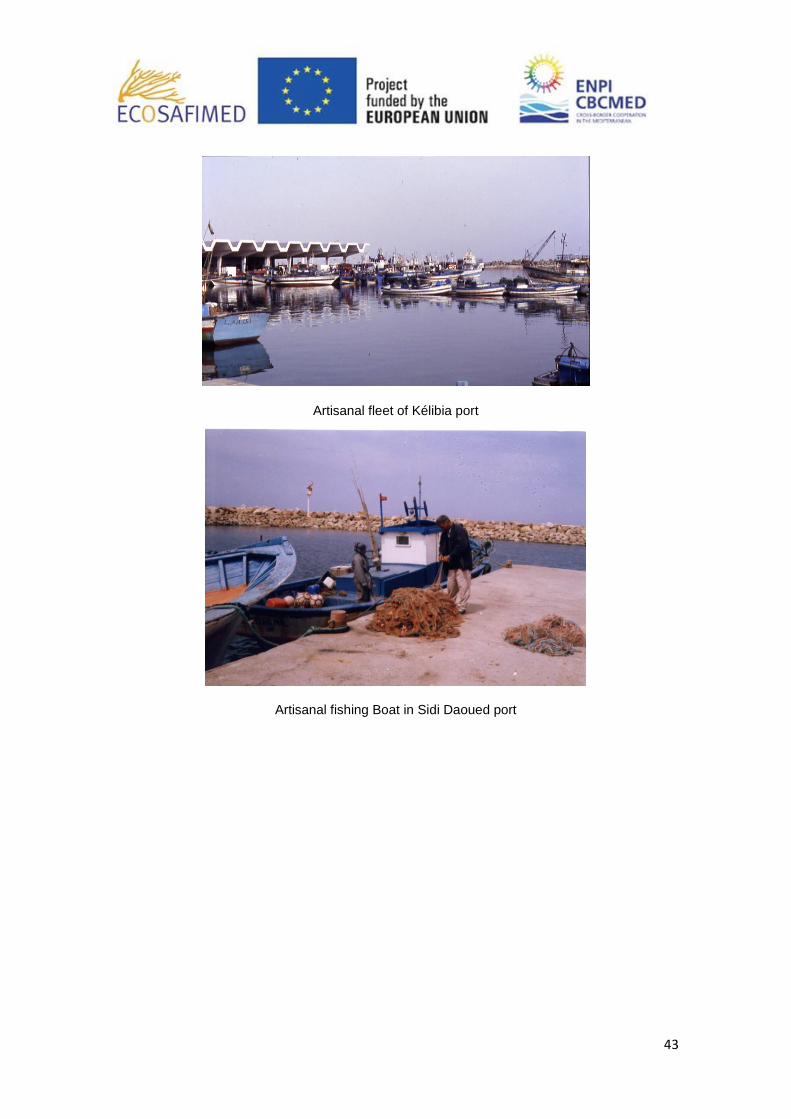
Artisanal fleet of Kélibia port
Artisanal fishing Boat in Sidi Daoued port