tower a tower c tower b tower b current 110.7...
TRANSCRIPT
46Rezoning Report Burrard Gateway ProjectMarch 13, 2013
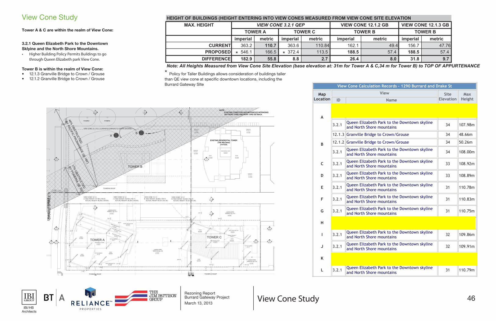
HEIGHT OF BUILDINGS (HEIGHT ENTERING INTO VIEW CONES MEASURED FROM VIEW CONE SITE ELEVATIONMAX. HEIGHT
imperial metric imperial metric imperial metric imperial metricCURRENT 363.2 110.7 363.6 110.84 162.1 49.4 156.7 47.76
PROPOSED 546.1 166.5 372.4 113.5 188.5 57.4 188.5 57.4 DIFFERENCE 182.9 55.8 8.8 2.7 26.4 8.0 31.8 9.7
Note: All Heights Measured from View Cone Site Elevation (base elevation at: 31m for Tower A & C,34 m for Tower B) to TOP OF APPURTENANCE
TOWER CTOWER A TOWER B TOWER BVIEW CONE 3.2.1 QEP VIEW CONE 12.1.2 GB VIEW CONE 12.1.3 GB
View Cone Study
View Cone Study
Tower A & C are within the realm of View Cone:
3.2.1 Queen Elizabeth Park to the Downtown Sklyine and the North Shore Mountains.• Higher Building Policy Permits Buildings to go
through Queen Elizabeth park View Cone.
Tower B is within the realm of View Cone: • 12.1.3 Granville Bridge to Crown / Grouse• 12.1.2 Granville Bridge to Crown / Grouse
*
* Policy for Taller Buildings allows consideration of buildings taller than QE view cone at specific downtown locations, including the Burrard Gateway SIte
*
View Cone Calculation Records – 1290 Burrard and Drake St
Map Location
View Site Elevation
Max Height ID Name
A
12.1.3 Granville Bridge to Crown/Grouse 34 47.76m
12.1.2 Granville Bridge to Crown/Grouse 34 49.40m
3.2.1 Queen Elizabeth Park to the Downtown skyline and North Shore mountains 34 107.98m
B
12.1.3 Granville Bridge to Crown/Grouse 34 48.66m
12.1.2 Granville Bridge to Crown/Grouse 34 50.26m
3.2.1 Queen Elizabeth Park to the Downtown skyline and North Shore mountains 34 108.00m
C 3.2.1 Queen Elizabeth Park to the Downtown skyline and North Shore mountains 33 108.92m
D 3.2.1 Queen Elizabeth Park to the Downtown skyline and North Shore mountains 33 108.89m
E 3.2.1 Queen Elizabeth Park to the Downtown skyline and North Shore mountains 31 110.78m
F 3.2.1 Queen Elizabeth Park to the Downtown skyline and North Shore mountains 31 110.83m
G 3.2.1 Queen Elizabeth Park to the Downtown skyline and North Shore mountains 31 110.75m
H 3.2.1 Queen Elizabeth Park to the Downtown skyline and North Shore mountains 31 110.70m
I 3.2.1 Queen Elizabeth Park to the Downtown skyline and North Shore mountains 32 109.86m
J 3.2.1 Queen Elizabeth Park to the Downtown skyline and North Shore mountains 32 109.91m
K 3.2.1 Queen Elizabeth Park to the Downtown skyline and North Shore mountains 31 110.84m
L 3.2.1 Queen Elizabeth Park to the Downtown skyline and North Shore mountains 31 110.79m
Urban Design Panel Review SubmissionBurrard GatewayOctober 10th, 2012
View Cone Analysis
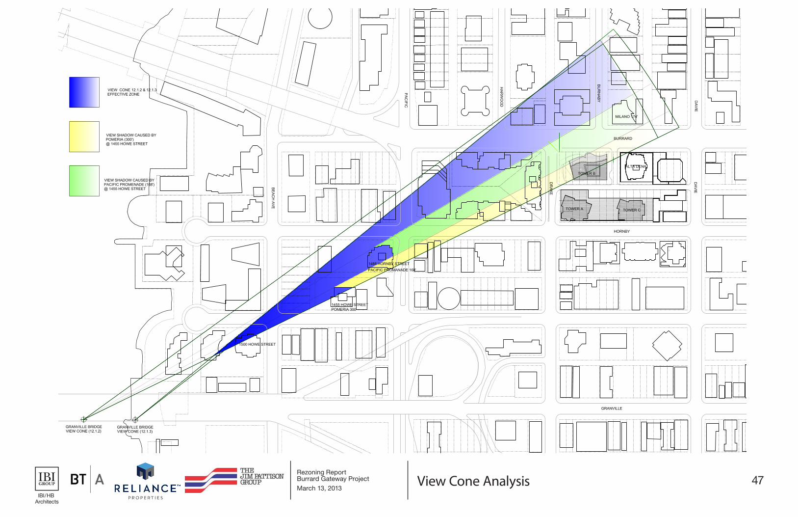
47Rezoning Report Burrard Gateway ProjectMarch 13, 2013
Urban Design Panel Review SubmissionBurrard GatewayOctober 10th, 2012
View Cone Analysis View Cone Analysis
48Rezoning Report Burrard Gateway ProjectMarch 13, 2013
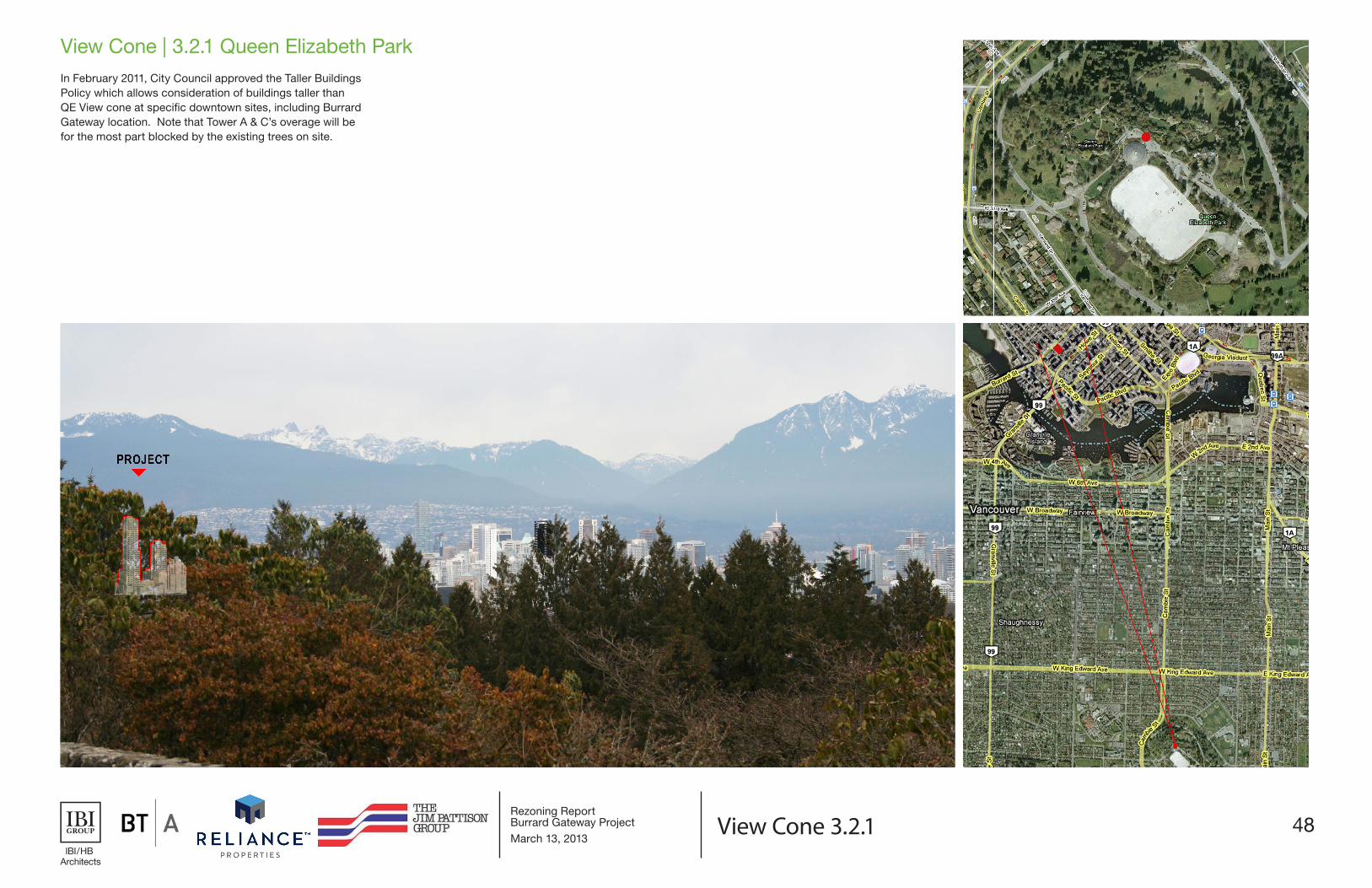
View Cone 3.2.1
View Cone | 3.2.1 Queen Elizabeth ParkIn February 2011, City Council approved the Taller Buildings Policy which allows consideration of buildings taller than QE View cone at specific downtown sites, including Burrard Gateway location. Note that Tower A & C’s overage will be for the most part blocked by the existing trees on site.