traffic management plan february 2012
TRANSCRIPT
Rural City of Murray Bridge
Ferries McDonald Road Traffic Management Plan
February 2012
33/16049/47868 Ferries McDonald RoadTraffic Management Plan
This Traffic Management Plan (“Report”):
1. has been prepared by GHD Pty Ltd (“GHD”) for the Rural City of Murray Bridge;
2. may only be used and relied on by Rural City of Murray Bridge
3. must not be copied to, used by, or relied on by any person other than Rural City ofMurray Bridge without the prior written consent of GHD;
4. may only be used for the purpose of traffic management (and must not be used for anyother purpose).
GHD and its servants, employees and officers otherwise expressly disclaim responsibility to anyperson other than the Rural City of Murray Bridge arising from or in connection with this Report.
To the maximum extent permitted by law, all implied warranties and conditions in relation to theservices provided by GHD and the Report are excluded unless they are expressly stated toapply in this Report.
The services undertaken by GHD in connection with preparing this Report:
were limited to those specifically detailed in section 1.2 of this Report;
Subject to the paragraphs in this section of the Report, the opinions, conclusions and anyrecommendations in this Report are based on conditions encountered and information reviewedat the time of preparation and may be relied on until 6 months, after which time, GHD expresslydisclaims responsibility for any error in, or omission from, this Report arising from or inconnection with those opinions, conclusions and any recommendations.
33/16049/47868 Ferries McDonald Road Traffic Management Plan
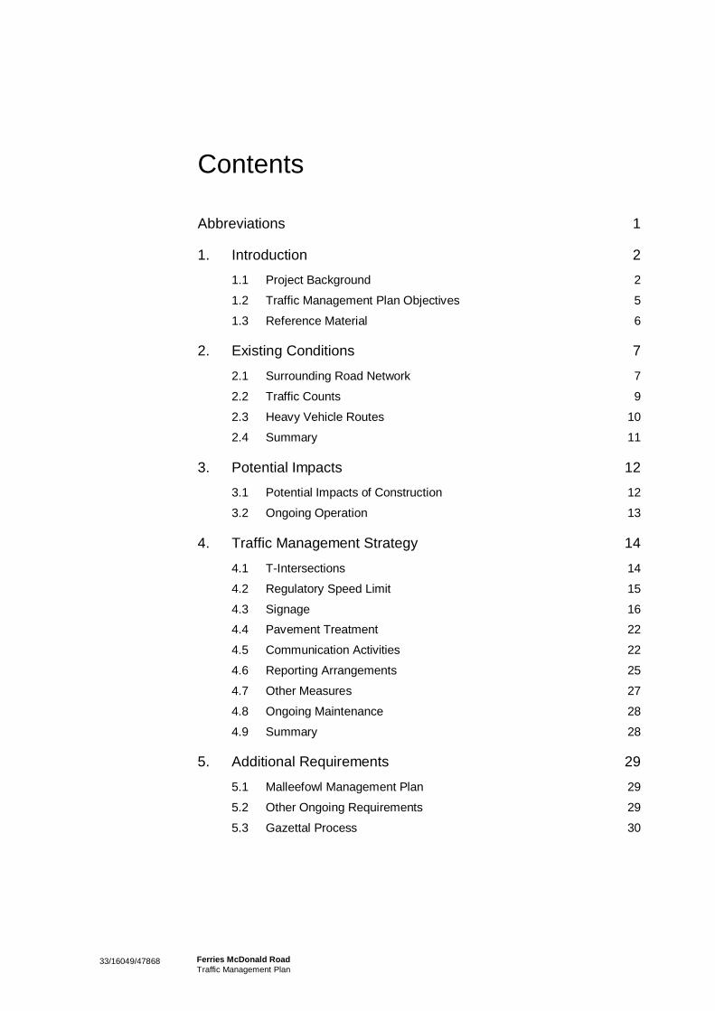
Contents
Abbreviations 1
1. Introduction 2
1.1 Project Background 2 1.2 Traffic Management Plan Objectives 5 1.3 Reference Material 6
2. Existing Conditions 7
2.1 Surrounding Road Network 7 2.2 Traffic Counts 9 2.3 Heavy Vehicle Routes 10 2.4 Summary 11
3. Potential Impacts 12
3.1 Potential Impacts of Construction 12 3.2 Ongoing Operation 13
4. Traffic Management Strategy 14
4.1 T-Intersections 14 4.2 Regulatory Speed Limit 15 4.3 Signage 16 4.4 Pavement Treatment 22 4.5 Communication Activities 22 4.6 Reporting Arrangements 25 4.7 Other Measures 27 4.8 Ongoing Maintenance 28 4.9 Summary 28
5. Additional Requirements 29
5.1 Malleefowl Management Plan 29 5.2 Other Ongoing Requirements 29 5.3 Gazettal Process 30
33/16049/47868 Ferries McDonald RoadTraffic Management Plan
Table IndexTable 1 Vehicle Speeds along Ferries McDonald Road 10Table 2 Average Annual Daily Traffic along Ferries
McDonald Road 10Table 3 Proposed Message Content for Temporary VMS
Signs 19Table 4 Summary of Signage Requirements 21Table 5 Communication Activities to Ensure High Level of
Public Awareness 23Table 6 Ongoing Maintenance Responsibilities and
Measures 28
Figure IndexFigure 1 Proposed North South Corridor 3Figure 2 Locality Map 5Figure 3 Typical Cross Sections of Ferries McDonald Road 7Figure 4 Intersection of Ferries McDonald Road and
Garwood Road 8Figure 5 Intersection of Ferries McDonald Road and
Chauncey’s Line Road 9Figure 6 Regional Network for 26m B – Double Vehicles
(GML) 11Figure 7 Staggered T-intersection Alignments at the
Entrances to the Ferries McDonald ConservationPark 15
Figure 8 Malleefowl Informative Road Sign 17Figure 9 Existing National Parks and Wildlife Service
Signage 18Figure 10 Example of a Trailer Mounted Transportable
Variable Message Sign 20
AppendicesA Site Location PlanB Commonwealth NoticesC Informative Road SignD Traffic Control Plans (Signs Locations)E Log Book TemplateF Roadside Inspection Checklist
1 33/16049/47868 Ferries McDonald Road Traffic Management Plan
Abbreviations
NPW Act South Australian National Parks and Wildlife Act 1972
EPBC Act Commonwealth Environment Protection and Biodiversity Conservation Act 1999
GHD GHD Pty Ltd
RCMB Rural City of Murray Bridge (Council)
DTEI South Australian Department for Transport, Energy and Infrastructure
DPTI South Australian Department of Planning, Transport and Infrastructure
DENR South Australian Department of Environment and Natural Resources
DSEWP&C Commonwealth Department of Sustainability, Environment, Water, Population and Communities
MRDB Murraylands Regional Development Board
FMCP Ferries McDonald Conservation Park
MCP Monarto Conservation Park
AADT Average Annual Daily Traffic
GML General Mass Limits
EDD Extended Design Domain
NDD Normal Design Domain
VMS Variable Message Sign
LED Light Emitting Diode
RAV Restricted Access Vehicle
Note: At the time of preparation of this report, the South Australian Department for Transport, Energy and Infrastructure (DTEI) underwent of reorganisation and name change becoming the Department of Planning, Transport and Infrastructure (DPTI). For the purpose of this report the current name (DPTI) has been adopted (except when directly referencing a condition of approval which still uses the original departmental name).
233/16049/47868 Ferries McDonald RoadTraffic Management Plan
1. Introduction
This Traffic Management Plan outlines the actions and management strategies to protect localpopulations of Malleefowl from impacts associated with the upgrade of the Ferries McDonald Road in theMonarto District of South Australia. Malleefowl is listed as a vulnerable species in South Australia underthe National Parks and Wildlife Act 1972 (NPW Act) and as vulnerable under the Environment Protectionand Biodiversity Conservation Act 1999 (EPBC Act).
This Plan has been developed by GHD Pty Ltd (GHD) in discussions with representatives from the RuralCity of Murray Bridge (RCMB), the South Australian Department for Planning, Transport andInfrastructure (DPTI), the South Australian Department of Environment and Heritage (DENR) and theCommonwealth Department of Sustainability, Environment, Water, Population and Communities(DSWP&C).
This plan is being prepared to ensure appropriate mitigation measures are in place for the upgrade ofFerries McDonald Road and ensuring that the conditions imposed by DSWP&C are met.
1.1 Project BackgroundThe following sections provide background information and purpose of the Ferries McDonald RoadUpgrade and Traffic Management Plan.
1.1.1 Ferries McDonald Road Upgrade
In December 2005, the Murraylands Regional Development Board (MRDB), as the lead agency of aconsortium of stakeholders commissioned the preparation of the North South Transport CorridorBusiness Case. The consortia comprised of the Murraylands Regional Development Board, MurrayMallee Local Government Association, Mid North Regional Development Board and Central LocalGovernment Region of SA, with each group representing numerous local governments.
This report compiled evidence from previous efforts from stakeholders and provided a business casewhich highlighted the strategic importance of a north-south transport corridor, which is shown in Figure 1.The business case also provided a model for local governments in the preparation of funding to supportthe implementation of the north-south corridor.
The overarching purpose of the north-south corridor is identified in the report as:
“Upgrading the nominated roads will enable the establishment of a North South Transport Corridor thatwill …create a transport route of strategic significance not only for South Australia, but also supportinterstate freight access”
Ferries McDonald Road is clearly identified as a section of the future north-south corridor. The reportalso clearly identifies the economic and social benefits of the sealing and upgrade of Ferries McDonaldRoad to allow heavy vehicle traffic, including, but not limited to the following:
To provide access for B-Double and other Heavy Vehicle transport that supports the wine and grainsindustry and the emerging timber industry
To link Langhorne Creek vignerons with processing facilities in the Barossa Valley and Riverland
To assist in the attraction of further economic investment in the region by reducing travel times
333/16049/47868 Ferries McDonald RoadTraffic Management Plan
Figure 1 Proposed North South Corridor
Source: Adapted from North South Corridor Business Case
1.1.2 Traffic Management Plan
Ferries McDonald Road is located within the RCMB Government boundary and has been identified as apriority infrastructure upgrade for Council. The RCMB intends to upgrade Ferries McDonald Road duringthe 2011/2012 financial year. Ferries McDonald Road is located approximately 15 km south west ofMurray Bridge as shown in Figure 2 (an additional site location plan is shown in Appendix A). The totallength of road to be upgraded is approximately 11.7 km extending from the Chauncey’s Line / Kangaroo /Ferries McDonald Road Intersection to the South Eastern Freeway.
A section of Ferries McDonald Road passes through the Ferries McDonald Road Conservation Park(FMCP) (841 Ha) for approximately 2 km between Chauncey’s Line Road and Garwood Road. FerriesMcDonald Road also passes adjacent to the Monarto Conservation Park (MCP) (240 Ha) which abutsthe Project along the western side.
433/16049/47868 Ferries McDonald RoadTraffic Management Plan
Under the Commonwealth Environment Protection and Biodiversity Conservation (EPBC) Act 1999, if aproposed action (project/development) is likely to have a significant impact on a Matter of NationalEnvironmental Significance (MNES), approval must be obtained from the Minister for Sustainability,Environment, Water, Populations and Communities before it can proceed. MNES include listedthreatened species and ecological communities and migratory species.
The FMCP and MCP contain remnant and planted native vegetation as well as provide habitat to avariety of native fauna. A Flora and Fauna assessment of the proposed project areas was undertaken forthe RCMB by EBS (2008), during which no Malleefowl were observed. However, based on previousrecordings of Malleefowl within the vicinity of the project area by DENR, EBS (2008) determinedMallefowl as ‘likely to occur in survey area’. EBS (2008) also determined the EPBC listed RainbowBeaeater and Red-lored Whistler as ‘likely to occur in survey area’ in addition to four EPBC listed plantspecies recorded as ‘known to occur or possibly occurs in study area’.
An updated EPBC referral number 2008/4211 Version 2 dated October 2009 citing these findings wassubmitted for the upgrade of Ferries McDonald Road from the Chauncey’s Line & Kangaroo RoadIntersection to the South Eastern Freeway at Monarto South. This followed an earlier submission ofEPBC Referral 2008/4211 in May 2008 upon which DSEWP&C determined the proposed action to‘controlled’ and requested further information. Based on Version 2 of EPBC referral 2008/4211 datedOctober 2009 DSEWP&C returned an approval dated 30th November 2010 with the controlling provision‘Listed threatened species and communities (sections 18 & 18A). Condition 1 of the DSEWP&C approvalstates that:
“Prior to the commencement of construction, a Traffic Management Plan designed to reduce thelikelihood of vehicle strike on Malleefowl, must be submitted to the Department by the person takingthe action and approved by the Minister...”
This Traffic Management Plan has been prepared to satisfy Condition 1 of the DSEWP&C approval.
533/16049/47868 Ferries McDonald RoadTraffic Management Plan
Figure 2 Locality Map
1.2 Traffic Management Plan ObjectivesThe objective of this traffic management plan is to outline measures by which the likelihood of vehiclestrike on Malleefowl during the construction and operation of the section of Ferries McDonald Roadthrough the Ferries McDonald Conservation Park and adjacent to Monarto Conservation Park. This willbe achieved by addressing each of the condition 1 requirements (condition 1a – 1l). The DSEWP&Cconditions of approval and variation dated 30 November 2011 are shown in Appendix B.
The Plan also provides some information relating to the existing traffic conditions and potential impacts toMalleefowl which has been used in the development of the Traffic Management Strategy. The structureof this report is as follows:
Introduction: Project background
Existing Traffic Conditions: A description of the traffic existing traffic conditions along the section ofFerries McDonald Road and within the surrounding road network.
Potential Impacts: A brief discussion on the potential impacts to Malleefowl.
Traffic Management Strategy: A detailed description of the management strategy which addresseseach of the requirements of Condition 1 of the approval for the referral (EPBC 2008/4211) andvariation dated 30 November 2011.
Additional Requirements: Brief information regarding the other requirements listed in the approval forthe referral (EPBC 2008/4211) and the gazettal process which is required to allow B-Double vehiclesto use Ferries McDonald Road.

633/16049/47868 Ferries McDonald RoadTraffic Management Plan
1.3 Reference MaterialThe following guidelines, standards and other references have been used in the preparation of this plan:
MRDB North South Transport Corridor Business Case 2006
Australian Standard 1742.1–2009, Manual of uniform traffic control devices Part 1: Generalintroduction and index of signs, Part 2: Traffic control devices for general use and Part 4: Speedcontrols
DPTI Operational Instruction 2.36: Variable Message Signs
Austroads Guide to Traffic Management Part 10: Traffic Control and Communication Devices
Austroads Guide to Road Safety Part 3: Speed Limits and Speed Management
Austroads Guide to Pavement Technology Park 4K: Seals
DPTI Spatial Intelligence & Road Assets: Route Network for 26m B-Double Vehicles (GML)
DPTI Spatial Intelligence & Road Assets: Annual Average Daily Traffic Estimate
DPTI Heavy Vehicle Access Framework Version 2 April 2009
733/16049/47868 Ferries McDonald RoadTraffic Management Plan
2. Existing Conditions
This section outlines the existing traffic conditions along Ferries McDonald Road and the surroundingnetwork. Details of the surrounding road network, heavy vehicle routes and traffic data are included.
2.1 Surrounding Road NetworkFerries McDonald Road is located approximately 15 km west of Murray Bridge as shown previously inFigure 2 (shown also in the locality plan in Appendix A). A description of the road network for key roadsand intersections are provided in the following sections.
2.1.1 Ferries McDonald Road
Ferries McDonald Road is a two way (one lane in each direction) road running in an approximately north-south direction. Ferries McDonald is approximately 14 km long, connecting the South Eastern Freewayto the north and Chauncey’s Line Road to the south. There is no speed sign therefore the default speed-limit for a non-urban road applies (100 km/hr).
There is light to medium density vegetation adjacent to the carriageway along the majority of the road.There is a distinct change in the roadside environment through the Ferries McDonald Conservation Park.Ferries McDonald Road passes through the Ferries McDonald Conservation Park for a section which isapproximately 2 km in length from Garwood Road in the north to Chauncey’s Line Road in the South. Forthe entirety of this section, high density vegetation extends to the edge of the carriageway as shown inFigure 3. Existing drainage in this section is made up of a series of ‘cut outs’ at the edge of thecarriageway which allows water runoff to drain freely away from the carriageway. Although entirelystraight through the Conservation Park, there are several vertical curves which could cause hazardousconditions for overtaking manoeuvres. Traffic count data for Ferries McDonald Road is provided insection 2.2.
Figure 3 Typical Cross Sections of Ferries McDonald Road
Dense vegetation at the edge of carriageway Loose aggregate at the edge of the carriageway
833/16049/47868 Ferries McDonald RoadTraffic Management Plan
2.1.2 Garwood Road
Garwood Road is a two way (one lane in each direction) road running in an approximately north-east tosouth-west direction. This road is approximately 2.6 km long providing access to adjacent ruralproperties. There is no speed sign therefore the default speed-limit for a non-urban road applies (100km/hr). Ferries McDonald Road and Garwood Road meet as a standard uncontrolled T-intersection withthere being clear priority for traffic along Ferries McDonald Road as shown in Figure 4.
Figure 4 Intersection of Ferries McDonald Road and Garwood Road
Looking south along Ferries McDonald Roadtowards Garwood Road
Looking west along Garwood Road (from FerriesMcDonald Road)
2.1.3 Chauncey’s Line Road and Kangaroo Road
Chauncey’s Line Road is a two way, (one lane in each direction) road running in an approximately north-east to south-west direction. This road connects Callington-Strathalbyn Road to the west and BrinkleyRoad to the east. There is no speed sign implying that the default speed-limit for a non-urban roadapplies (100 km/hr).
Kangaroo Road is a two way (one lane in each direction) running in an approximately north to southdirection. This road is connects to Chauncey’s Line Road to the north and Wellington Road to the south.There is no speed sign implying that the default speed-limit for a non-urban road applies (100 km/hr).The road has recently being sealed and upgraded as part of the ‘Roads to Recovery’ program.
The intersection of Ferries McDonald Road / Chauncey’s Line Road and Kangaroo Road is a staggeredT-intersection type arrangement as shown in Figure 5.
933/16049/47868 Ferries McDonald RoadTraffic Management Plan
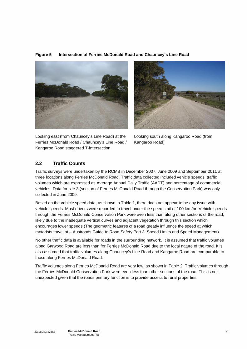
Figure 5 Intersection of Ferries McDonald Road and Chauncey’s Line Road
Looking east (from Chauncey’s Line Road) at theFerries McDonald Road / Chauncey’s Line Road /Kangaroo Road staggered T-intersection
Looking south along Kangaroo Road (fromKangaroo Road)
2.2 Traffic CountsTraffic surveys were undertaken by the RCMB in December 2007, June 2009 and September 2011 atthree locations along Ferries McDonald Road. Traffic data collected included vehicle speeds, trafficvolumes which are expressed as Average Annual Daily Traffic (AADT) and percentage of commercialvehicles. Data for site 3 (section of Ferries McDonald Road through the Conservation Park) was onlycollected in June 2009.
Based on the vehicle speed data, as shown in Table 1, there does not appear to be any issue withvehicle speeds. Most drivers were recorded to travel under the speed limit of 100 km /hr. Vehicle speedsthrough the Ferries McDonald Conservation Park were even less than along other sections of the road,likely due to the inadequate vertical curves and adjacent vegetation through this section whichencourages lower speeds (The geometric features of a road greatly influence the speed at whichmotorists travel at – Austroads Guide to Road Safety Part 3: Speed Limits and Speed Management).
No other traffic data is available for roads in the surrounding network. It is assumed that traffic volumesalong Garwood Road are less than for Ferries McDonald Road due to the local nature of the road. It isalso assumed that traffic volumes along Chauncey’s Line Road and Kangaroo Road are comparable tothose along Ferries McDonald Road.
Traffic volumes along Ferries McDonald Road are very low, as shown in Table 2. Traffic volumes throughthe Ferries McDonald Conservation Park were even less than other sections of the road. This is notunexpected given that the roads primary function is to provide access to rural properties.

1033/16049/47868 Ferries McDonald RoadTraffic Management Plan
Table 1 Vehicle Speeds along Ferries McDonald Road
Date Location Vehicle Speed (km/hr)85th Percentile Mean
Dec 2007Site 1: 100 metres north of Mountain ViewRoad
94
June 2009 85
September 2011 94
Dec 2007
Site 2: Between Altmann Road andGarwood Road
89
June 2009 91
September 2011 95
June 2009Site 3: Between Garwood Road andChauncey’s Line Road
82
Table 2 Average Annual Daily Traffic along Ferries McDonald Road
Location (see Figure 2 for roadlocations)
Average Annual Daily Traffic (AADT)*
Dec 2007 June 2009 September 2011
Site 1: 100 metres north of MountainView Road
120 141 (3%) 166 (15%)
Site 2: Between Altmann Road andGarwood Road
43 51 (4%) 115 (11%)
Site 3: Between Garwood Road andChauncey’s Line Road
N/A 44 N/A
*Note: Percentage of commercial vehicles is indicated in brackets where data available
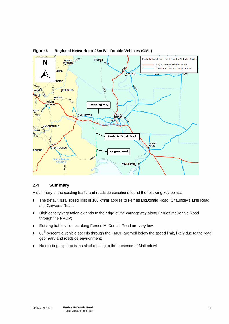
2.3 Heavy Vehicle RoutesExisting gazetted heavy vehicle routes for B-Doubles, General Mass Limits (GML), in the surroundingroad network are shown in Figure 6. As discussed previously in section 1.1.1, it is intended that FerriesMcDonald Road becomes a heavy vehicle route linking into the existing network at the Princess Highway(as indicated by the green dashed line in Figure 6). Other key B-Double routes in the region are theCallington to Strathalbyn and Murray Bridge to Mannum Roads.
1133/16049/47868 Ferries McDonald RoadTraffic Management Plan
Figure 6 Regional Network for 26m B – Double Vehicles (GML)
2.4 SummaryA summary of the existing traffic and roadside conditions found the following key points:
The default rural speed limit of 100 km/hr applies to Ferries McDonald Road, Chauncey’s Line Roadand Garwood Road;
High density vegetation extends to the edge of the carriageway along Ferries McDonald Roadthrough the FMCP;
Existing traffic volumes along Ferries McDonald Road are very low;
85th percentile vehicle speeds through the FMCP are well below the speed limit, likely due to the roadgeometry and roadside environment;
No existing signage is installed relating to the presence of Malleefowl.

1233/16049/47868 Ferries McDonald RoadTraffic Management Plan
3. Potential Impacts
This project will have numerous potential impacts both during construction and on the operation ofFerries McDonald Road. These potential impacts have also been identified in the MalleefowlManagement Plan (GHD 2011).
This Traffic Management plan deals specifically with reducing the likelihood of vehicle strike onMalleefowl. Numerous mitigation measures to achieve this are outlined in the Traffic ManagementStrategy (see chapter 4).The Malleefowl Management Plan also details mitigation measures to protectlocal populations of Mallefowl in the area. There is some duplication in the mitigation measures proposedin both plans although the two documents contain separate information that shall be incorporated as partof the RCMB total management plan for the project.
3.1 Potential Impacts of ConstructionAssuming that no mitigation measures are implemented, the proposed construction of the upgradedFerries McDonald Road could result in the following impacts upon Malleefowl:
Removal or damage to Malleefowl habitat.
Risk of fire outbreak due to construction activity (e.g. petrol engines and construction personnelworking).
Risk of direct mortality or injury to both adult and/or juvenile Malleefowl by machinery, plant andconstruction vehicles.
Risk that both adult and/or juvenile Malleefowl may move into the construction zone during workactivities. Once within the construction zone, individuals would be at a high risk of mortality or injuryeither by machinery or through other activities occurring within the construction zone. Alternatively,Malleefowl may avoid the construction zone forming a temporary partial barrier to Malleefowlmovements and/or dispersal throughout the region.
Entrapment of Malleefowl in open excavations/trenches.
Human habituation of Malleefowl given presence of construction personnel.
Construction activity could disturb Malleefowl (e.g. noise, ground vibrations). Malleefowl usinghabitat in the vicinity of the study area may move elsewhere or otherwise alter their usual behaviourduring the construction works (e.g. adults may abandon nests).
Introduction of new or spread of existing weeds during the construction process. There is a possibilitythat more invasive or otherwise damaging environmental weeds are introduced to the site. Theconstruction process may also facilitate the spread of existing weeds into new areas, both within andbeyond the study area.
Introduction of disease/pathogens to local Malleefowl population.

1333/16049/47868 Ferries McDonald RoadTraffic Management Plan
3.2 Ongoing OperationAssuming that no mitigation measures are implemented, the operation of the upgraded FerriesMcDonald Road could result in the following impacts to Malleefowl:
Risk of injury or mortality to adults and juvenile Malleefowl through road strike (The RCMBanticipates that once the road upgrade is completed and connected to other gazetted routes, trafficvolumes will increase to 400 vehicles per day with approximately 70% heavy vehicles).
Increase in road spill resources for Malleefowl (i.e. split grain may lead to increased road strike).
Roadside vegetation maintenance impacts on Malleefowl habitat (upgraded road will require ongoingroadside vegetation maintenance in accordance with DPTI Specification Part 815: RoadsideVegetation Maintenance – September 2010).
Risk of fire outbreak through anthropogenic sources due to increased traffic flows.
Proliferation of predators i.e. increased traffic flow may lead to increased incidence of road kill(kangaroos, rabbits) providing food source for predators.
Malleefowl may avoid the upgraded road forming a temporary partial barrier to Malleefowlmovements and/or dispersal throughout the region.
Introduction of new or spread of existing weeds through increased traffic flows. There is a possibilitythat more invasive or otherwise damaging environmental weeds are introduced to the site. Increasedtraffic flows may also facilitate the spread of existing weeds into new areas, both within and beyondthe study area.
Introduction of disease/pathogens to local Malleefowl population.

14 33/16049/47868 Ferries McDonald Road Traffic Management Plan
4. Traffic Management Strategy
The following chapter outlines the traffic management strategy to ensure that there is a reduced likelihood of vehicle strike on Malleefowl. Details of actions undertaken, including actions still required to be undertaken by key stakeholders, to satisfy each of the requirements of Condition 1 (requirements 1a – 1l) of the approval. The DSEWP&C conditions of approval are shown in Appendix B.
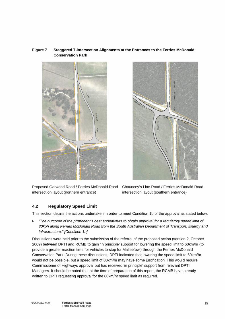
4.1 T-Intersections This section details the actions undertaken in order to meet Condition 1a of the approval as varied on 30 November 2011 and stated below:
“The proposed design of the t-intersection at the intersection of Garwood Road and Ferries McDonald Road and the t-intersection at the intersection of Chauncey’s Line Road and Ferries McDonald Road…” [Condition 1a]
Both intersections will be staggered T-intersection types which are anticipated to reduce the likelihood of strike on Malleefowl by causing drivers to slow down or stop before entering the park as shown in Figure 7 (concept alignment shown only). This would also mean the drivers would be travelling a slower speed when driving past the informative road signs and Conservation Park signs increasing the likelihood that drivers will read all the information displayed.
To date, detailed engineering design of the Chauncey’s Line Road / Ferries McDonald Road and of the Garwood Road / Ferries McDonald intersections have been prepared and will be constructed during a similar timeframe to the construction works for the section of road through the Ferries McDonald Conservation Park.
The designs of these intersections have considered the following key points:
The new road reserve created by the new road and intersection alignments shall not intrude into the Conservation Park or disturb native vegetation;
Land acquisition at both intersections is to be minimised;
The geometric layout of the northern and southern intersection will provide for turning manoeuvres for B-Double vehicles (design vehicle);
Provision has been made in the design of the northern intersection to allow for possible connection to the road easement along the north-eastern boundary of the Ferries McDonald Conservation Park.
Construction of these intersections and section of Ferries McDonald Road through the Ferries McDonald Conservation Park is currently scheduled to be undertaken during the 2011/2012 financial year pending any required approvals.
The final designs have prepared in accordance with Austroads Guidelines and other relevant road design standards.
1533/16049/47868 Ferries McDonald RoadTraffic Management Plan
Figure 7 Staggered T-intersection Alignments at the Entrances to the Ferries McDonaldConservation Park
Proposed Garwood Road / Ferries McDonald Roadintersection layout (northern entrance)
Chauncey’s Line Road / Ferries McDonald Roadintersection layout (southern entrance)
4.2 Regulatory Speed LimitThis section details the actions undertaken in order to meet Condition 1b of the approval as stated below:
“The outcome of the proponent’s best endeavours to obtain approval for a regulatory speed limit of80kph along Ferries McDonald Road from the South Australian Department of Transport, Energy andInfrastructure.” [Condition 1b]
Discussions were held prior to the submission of the referral of the proposed action (version 2, October2009) between DPTI and RCMB to gain ‘in principle’ support for lowering the speed limit to 60km/hr (toprovide a greater reaction time for vehicles to stop for Malleefowl) through the Ferries McDonaldConservation Park. During these discussions, DPTI indicated that lowering the speed limit to 60km/hrwould not be possible, but a speed limit of 80km/hr may have some justification. This would requireCommissioner of Highways approval but has received ‘in principle’ support from relevant DPTIManagers. It should be noted that at the time of preparation of this report, the RCMB have alreadywritten to DPTI requesting approval for the 80km/hr speed limit as required.
16 33/16049/47868 Ferries McDonald Road Traffic Management Plan
Additional discussions were undertaken between DPTI and GHD on Tuesday 20 September 2011 to determine an appropriate speed limit for the road. The outcome of this meeting was that a 60km/hr speed limit would be unacceptable to DPTI as it would not be consistent with driver’s expectations regarding the following:
Road alignment – road is very straight (although there are some vertical curves).
Road pavement – will be sealed allowing vehicles to travel safely at greater speeds.
Roadside environment / level of activity – undeveloped roadside with no public access points off Ferries McDonald Road through the FMCP.
These factors listed above are consistent with guidelines for selecting speed limits as outlined in Austroads Guide to Traffic Safety Part 3: Speed Limits and Speed Management.
DPTI representatives have agreed that given the impracticality to impose a 60km/hr speed limit, an 80km/hr speed limit would be the most suitable.
4.3 Signage This section details the actions undertaken in order to meet Conditions 1c, 1e and 1f of the approval as stated in the following sections. A summary of the signage requirements including locations and other details is provided in section 4.3.5.
The following sections provide commentary and clarification of the signage requirements such that relevant standards are also satisfied.
4.3.1 Advisory Speed Limit Sign
This section details the actions required in order to meet Condition 1c of the approval as stated below:
“Placement of signage to establish an advisory speed limit of 60kph for the section of upgraded road passing through the Ferries McDonald Conservation Park.” [Condition 1c]
The purpose of providing an advisory speed limit of 60km/hr through the section of road through the FMCP is to reduce the likelihood of vehicle strike on Malleefowl by encouraging lower vehicle speeds. Although not all motorists are anticipated to adopt the advisory speed limit, it is envisioned that a large percentage of drivers will, especially when this information is provided in conjunction with other information about the presence of Malleefowl.
Australian Standard 1742.2–2009 Part 2 details that advisory speed signs shall only be used in conjunction with warning signs and shall not be used as stand-alone signs. However, the advisory speed sign cannot be combined with a warning sign for Malleefowl because such warning signs (i.e. diamond shaped, yellow background type) cannot be used for Malleefowl (warning signs are only used for larger animals such as camels, kangaroos etc).
Accordingly, the Advisory Speed sign has been incorporated into the informative road sign designed by DPTI as described in section 4.3.2.
1733/16049/47868 Ferries McDonald RoadTraffic Management Plan
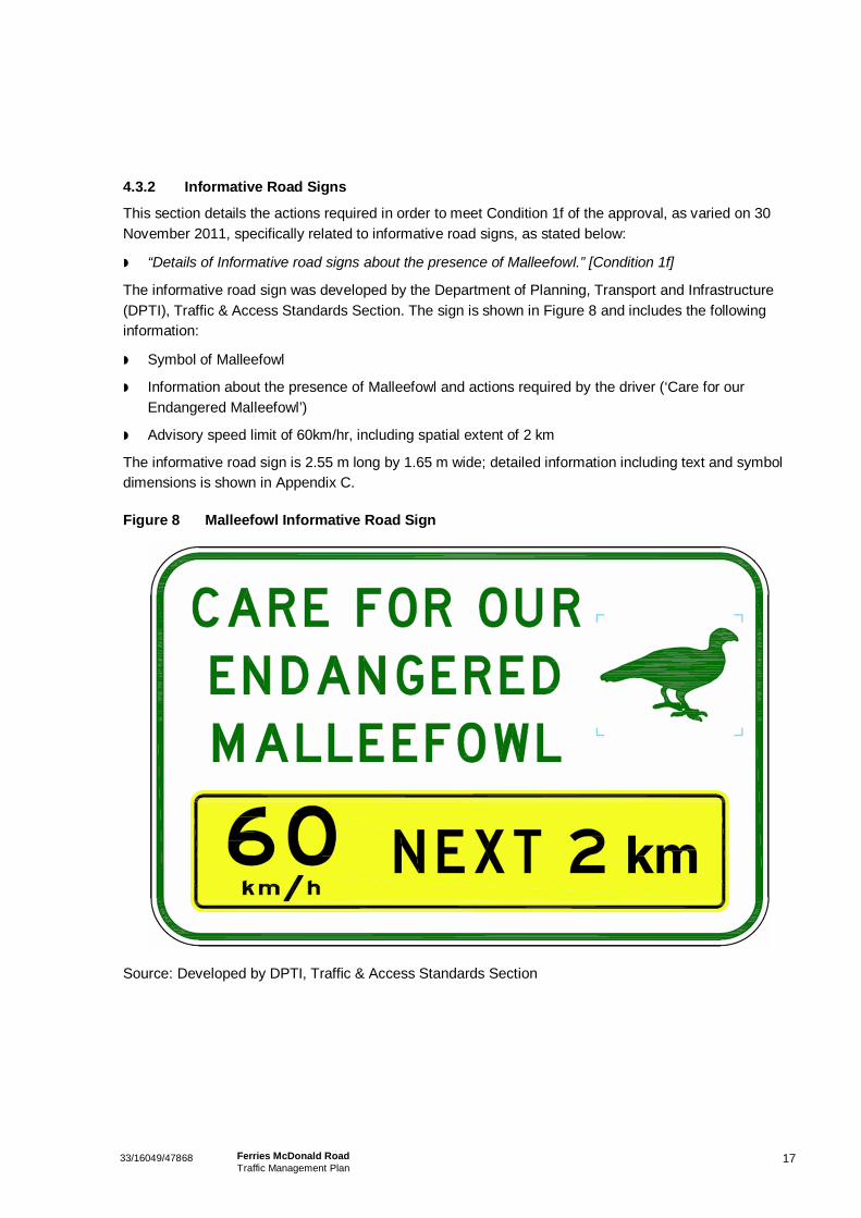
4.3.2 Informative Road Signs
This section details the actions required in order to meet Condition 1f of the approval, as varied on 30November 2011, specifically related to informative road signs, as stated below:
“Details of Informative road signs about the presence of Malleefowl.” [Condition 1f]
The informative road sign was developed by the Department of Planning, Transport and Infrastructure(DPTI), Traffic & Access Standards Section. The sign is shown in Figure 8 and includes the followinginformation:
Symbol of Malleefowl
Information about the presence of Malleefowl and actions required by the driver (‘Care for ourEndangered Malleefowl’)
Advisory speed limit of 60km/hr, including spatial extent of 2 km
The informative road sign is 2.55 m long by 1.65 m wide; detailed information including text and symboldimensions is shown in Appendix C.
Figure 8 Malleefowl Informative Road Sign
Source: Developed by DPTI, Traffic & Access Standards Section
1833/16049/47868 Ferries McDonald RoadTraffic Management Plan
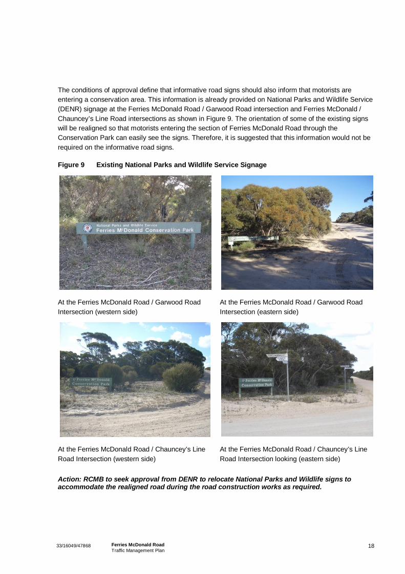
The conditions of approval define that informative road signs should also inform that motorists areentering a conservation area. This information is already provided on National Parks and Wildlife Service(DENR) signage at the Ferries McDonald Road / Garwood Road intersection and Ferries McDonald /Chauncey’s Line Road intersections as shown in Figure 9. The orientation of some of the existing signswill be realigned so that motorists entering the section of Ferries McDonald Road through theConservation Park can easily see the signs. Therefore, it is suggested that this information would not berequired on the informative road signs.
Figure 9 Existing National Parks and Wildlife Service Signage
At the Ferries McDonald Road / Garwood RoadIntersection (western side)
At the Ferries McDonald Road / Garwood RoadIntersection (eastern side)
At the Ferries McDonald Road / Chauncey’s LineRoad Intersection (western side)
At the Ferries McDonald Road / Chauncey’s LineRoad Intersection looking (eastern side)
Action: RCMB to seek approval from DENR to relocate National Parks and Wildlife signs toaccommodate the realigned road during the road construction works as required.
1933/16049/47868 Ferries McDonald RoadTraffic Management Plan
4.3.3 Temporary Electronic Vehicle Speed Monitory Signs
This section details the actions required in order to meet Condition 1e of the approval as stated below:
“Temporary electronic variable message signs must be in place to advise drivers of the potentialfor Malleefowl to be on the road. The temporary electronic variable message signs must be inaccordance with the requirements of the South Australian Department of Planning, Transport andInfrastructure and include details of the locations, design and dimensions of the signage must beincluded in the Traffic Management Plan. If, in the first 12 months of operation no incidents ofMalleefowl mortality are recorded, the person taking the action may write to the Department to seekwritten approval to remove the requirement for the temporary electronic variable message signs toremain in place. [Condition 1e]
This message could be vehicle actuated or permanently displayed on the screen. Information that shouldnot be included on the VMS is listed below with reasons stated:
Driver speed – due to potential for dangerous, speeding drivers
Advisory speed limit – it would be difficult to ensure that drivers knew that the displayed speed wasadvisory only and not regulatory which could lead to confusion
Symbols of Malleefowl – it would be difficult to give appropriate resolution such that the symbol is anaccurate representation of a Malleefowl
The VMS message has been developed in accordance with typical message structures for advisorysigns and in accordance with DPTI guidelines for the use of such signs, no more than three lines and nomore than eight words should be displayed on the sign. A problem statement first alerts the driver to thepresence of the problem. A location statement then alerts to driver to the spatial extent of the problem. Athird and final instruction statement is then provided so the driver is aware of their required action. Anadvisory message statement to further inform motorists of the presence of Malleefowl has beendeveloped in accordance with this design methodology and is shown in Table 3. DPTI have indicatedthat the location information is not required as this information is already displayed on the InformativeRoad Signs and to keep the message as brief as possible.
Given that VMS signs are a non-standard traffic control device, approval must be sought from DPTI forthe use of this device. RCMB have applied to receive this formal approval for a 12 month period asrequired.
Table 3 Proposed Message Content for Temporary VMS Signs
Message Structure Advisory Message
Problem MALLEEFOWL
Instruction DRIVE WITH CARE
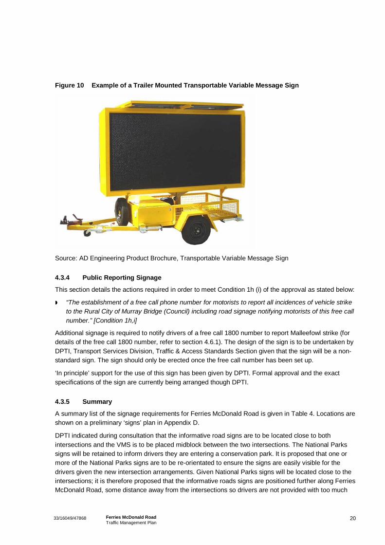
Typical features of VMS trailers include colour LED display, programmable for custom display message,solar recharging for continuous field use and security wheel locks. Dimensions vary for different VMStrailers, but typical sizes for the display area are in the order of 1.5 m wide to 3 m long. Detail related tothe proposed locations of the VMS trailers is given in section 4.3.5. An example of a VMS trailer is showin Figure 10.
2033/16049/47868 Ferries McDonald RoadTraffic Management Plan
Figure 10 Example of a Trailer Mounted Transportable Variable Message Sign
Source: AD Engineering Product Brochure, Transportable Variable Message Sign
4.3.4 Public Reporting Signage
This section details the actions required in order to meet Condition 1h (i) of the approval as stated below:
“The establishment of a free call phone number for motorists to report all incidences of vehicle striketo the Rural City of Murray Bridge (Council) including road signage notifying motorists of this free callnumber.” [Condition 1h,i]
Additional signage is required to notify drivers of a free call 1800 number to report Malleefowl strike (fordetails of the free call 1800 number, refer to section 4.6.1). The design of the sign is to be undertaken byDPTI, Transport Services Division, Traffic & Access Standards Section given that the sign will be a non-standard sign. The sign should only be erected once the free call number has been set up.
‘In principle’ support for the use of this sign has been given by DPTI. Formal approval and the exactspecifications of the sign are currently being arranged though DPTI.
4.3.5 Summary
A summary list of the signage requirements for Ferries McDonald Road is given in Table 4. Locations areshown on a preliminary ‘signs’ plan in Appendix D.
DPTI indicated during consultation that the informative road signs are to be located close to bothintersections and the VMS is to be placed midblock between the two intersections. The National Parkssigns will be retained to inform drivers they are entering a conservation park. It is proposed that one ormore of the National Parks signs are to be re-orientated to ensure the signs are easily visible for thedrivers given the new intersection arrangements. Given National Parks signs will be located close to theintersections; it is therefore proposed that the informative roads signs are positioned further along FerriesMcDonald Road, some distance away from the intersections so drivers are not provided with too much

2133/16049/47868 Ferries McDonald RoadTraffic Management Plan
information in a short space of time. The Public Reporting Signs are to be located further into theConservation Park again, for the same reasoning. This sign arrangement will constantly remind drivers ofthe presence of Mallefowl and will reinforce the message to take care.
Regulatory speed signs for the southern and northern intersections will be located at the commencementof Ferries McDonald Road close to the National Parks signs.
Informative road signage shall also be installed along the section of Ferries McDonald Road which runsadjacent to the MCP (one sign at the northern and southern end of the park). Additionally, two publicreporting signs (back to back) shall also be located at the mid-block between the extents of the MCP.
Table 4 Summary of Signage Requirements
Location Sign Type
Chauncey’s Line Road / Ferries McDonald Roadintersection (southern boundary of FMCP)
1 x Informative road sign
2 x National Parks and Wildlife signs (retainexisting, re-orientated as required)
1 x 80km/hr regulatory speed limit sign
1 x Public Reporting Sign
Ferries McDonald Road mid-block 1 x VMS trailer
Garwood Road / Ferries McDonald Roadintersection (northern boundary of FMCP)
1 x Informative Road Sign
2 x National Parks and Wildlife signs (retainexisting, re-orientated / relocate as required)
1 x 80km/hr regulatory speed limit sign
1 x Public Reporting Sign
Section of Ferries McDonald Road adjacent toMCP
2 x Informative Road Signs
2 x Public Reporting Sign

2233/16049/47868 Ferries McDonald RoadTraffic Management Plan
4.4 Pavement TreatmentThis section details the actions required in order to meet Condition 1d of the approval as stated below:
“Use of coarse aggregate seal on the surface of the upgrades road, except for the t-intersection atGarwood Road and Ferries McDonald Road and at Chauncey’s Line Road and Ferries McDonaldRoad.” [Condition 1d] – (intersection locations shown previously in Figure 7).
Austroads Guide to Pavement Technology Park 4K: Seals, provides detailed technical information onroad pavement seals, including operational advantages and disadvantages for various types (materials,size, etc).
Larger aggregate pavement seals produce high tyre/road noise, which is desirable in this instance togenerate noise to alert Malleefowl and other fauna of the presence of vehicles. Pavement noise will alsoprovide a reminder to drivers that they are travelling in a different traffic environment. This will beparticularly effective as it will be used in conjunction with other traffic management devices, such assignage. However, to ensure damage to vehicles and/or road pavement is kept to a minimum, it isrecommended that the coarse aggregate seal be used on the sealed shoulders of the road rather thanalong the trafficable lanes. An aggregate seal shall be used within the trafficable lanes which will providea relatively high tyre/road noise which is still practical from a road maintenance perspective. Such atreatment will still ensure passing traffic will be audible to the Malleefowl.
4.5 Communication ActivitiesThis section details the actions required in order to meet Condition 1g of the approval as stated below:
“Details of communication activities, including frequency, that will be undertaken to ensure acontinuing high level of public awareness of the need to protect Malleefowl in the Ferries McDonaldand Monarto Conservation Parks” [Condition 1g]
Proposed communication activities for achieving this requirement are outlined in Table 5. Communicationshall be undertaken by providing information media /marketing type mechanisms in addition to providinginfrastructure ‘at location’.

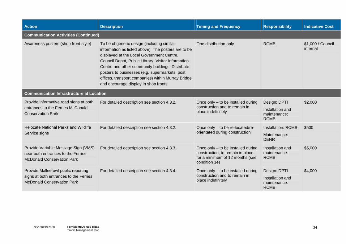
23 33/16049/47868 Ferries McDonald Road Traffic Management Plan
Table 5 Communication Activities to Ensure High Level of Public Awareness
Action Description Timing and Frequency Responsibility Indicative Cost
Communication Activities
Preparation of dedicated page on Rural City of Murray Bridge official website (fact sheet style)
Will provide the following information:
Location map of Ferries McDonald and Monarto Conservation Parks showing road and location relative to Murray Bridge and the Freeway
Information on the Ferries McDonald Road upgrade and about the presence of Malleefowl within the Ferries McDonald and Monarto Conservation Parks
Brief background on the ecology of Malleefowl and vulnerable classification
Importance of adhering to speed limits and to be aware of Malleefowl when in the area
Information on how to report Malleefowl strikes by free call number and other mechanisms (see section 4.6 on reporting arrangements)
The Traffic Management Plan, Malleefowl Management Plan and Construction Environmental Management Plan (see section 4.6.3) will be linked to the webpage. The launch of this page will be accompanied by a notice on the latest news reel on the website ‘home page’.
To be operational by the commencement of construction of the two intersections and section of road through the Ferries McDonald Conservation Park. To be constantly updated with any relevant information.
The Malleefowl Management Plan, Traffic Management Plan and CEMP shall be made available on the Council website prior to the commencement of construction. The plan must remain on the Council’s website unless otherwise advised in writing by the department.
RCMB Council internal
24 33/16049/47868 Ferries McDonald Road Traffic Management Plan
Action Description Timing and Frequency Responsibility Indicative Cost
Communication Activities (Continued)
Awareness posters (shop front style) To be of generic design (including similar information as listed above). The posters are to be displayed at the Local Government Centre, Council Depot, Public Library, Visitor Information Centre and other community buildings. Distribute posters to businesses (e.g. supermarkets, post offices, transport companies) within Murray Bridge and encourage display in shop fronts.
One distribution only RCMB $1,000 / Council internal
Communication Infrastructure at Location
Provide informative road signs at both entrances to the Ferries McDonald Conservation Park
For detailed description see section 4.3.2. Once only – to be installed during construction and to remain in place indefinitely
Design: DPTI
Installation and maintenance: RCMB
$2,000
Relocate National Parks and Wildlife Service signs
For detailed description see section 4.3.2. Once only – to be re-located/re-orientated during construction
Installation: RCMB
Maintenance: DENR
$500
Provide Variable Message Sign (VMS) near both entrances to the Ferries McDonald Conservation Park
For detailed description see section 4.3.3. Once only – to be installed during construction, to remain in place for a minimum of 12 months (see condition 1e)
Installation and maintenance: RCMB
$5,000
Provide Malleefowl public reporting signs at both entrances to the Ferries McDonald Conservation Park
For detailed description see section 4.3.4. Once only – to be installed during construction and to remain in place indefinitely
Design: DPTI
Installation and maintenance: RCMB
$4,000

2533/16049/47868 Ferries McDonald RoadTraffic Management Plan
4.6 Reporting ArrangementsThis section details the actions required in order to meet Condition 1h of the approval as stated below:
“Comprehensive reporting arrangements to notify the Department, relevant state agencies and thepublic of any Malleefowl mortalities on the Ferries McDonald Road, including but not limited to…”[Condition 1h]
Conditions 1h (i), (ii), (iii) and (iv) of the approval relate to monitoring are addressed in the followingsections. Details of reporting arrangements are given in section 4.6.4.
4.6.1 Free Call Number
This section details the actions required in order to meet Condition 1h (i) of the approval as stated below:
“The establishment of a free call phone number for motorists to report all incidences of vehicle striketo the Rural City of Murray Bridge (Council) including road signage notifying motorists of this free callnumber.”
One issue arising from the operation of the road is that the RCMB, or other authorities, may not be awareof vehicle strikes on Malleefowl. There could be incidents occurring of which relevant authorities have noknowledge of and hence the true extent of loss to endangered Malleefowl could go unnoticed. In thisinstance, further mitigation measures would not be undertaken due to a lack of information.
The main mechanism for reporting vehicle strikes to Malleefowl by general members of the public shallbe the establishment of a free call 1800 number. A free call 1800 number will provide a simple andobvious reporting mechanism for members of the public to utilise. There is minimal cost associated withproviding this service and this would increase the likelihood that RCMB would be aware of the true extentof Malleefowl strikes. The phone number should prompt the caller to provide information about date, timeand location of the reported Malleefowl strike.
Information of the free call number shall be provided on roadside signs at both entrances to the FerriesMcDonald and Monarto Conservations Parks (also see section 4.3.4). Details of the free call 1800number should also be provided as part of the communication activities, i.e. on website page and posters(also see section 4.5).
Reporting of Malleefowl Strike to the RCMB by general members of the public could also be madedirectly at the RCMB Council Offices.
Action: RCMB to set up 1800 number for the reporting of Malleefowl vehicle strikes frommembers of the public just prior to commencement of construction (including installation of theassociated signage).
4.6.2 Log Book
This section details the actions required in order to meet Condition 1h (ii) of the approval as statedbelow:
“A log book in which Council must keep records of all reported incidences of vehicle strike includingthe number of incidences and the location and time of day of each.”

2633/16049/47868 Ferries McDonald RoadTraffic Management Plan
A logbook is to be established for RCMB to record all incidents of vehicle strike on Malleefowl. The logbook is to record the following information regarding a potential strike on Malleefowl:
Date and time
Approximate location of the strike (for example 500m south of the Garwood Road /Ferries McDonaldRoad intersection)
Injury or Fatality
Details of any action taken
Any other relevant information
A template for this log book is provided in Appendix E.
A reported incidence of Malleefowl strike from members of the public (see section 4.6.1) or from theRCMB/DENR ongoing monitoring program (see section 4.6.3) should be recorded in the log book. IfRCMB/DENR finds injured or deceased Malleefowl through its ongoing monitoring program, the date andtime of the inspection shall be recorded.
4.6.3 Monitoring Arrangements
This section details the actions required in order to meet Condition 1h (iii) of the approval as statedbelow:
“Monitoring arrangements proposed by the Council other than the free call number.” [Condition 1h(iii)]
This condition requirement is very similar to Condition 2a as outlined in the Malleefowl Management Planas stated below:
“Detailed methods for identifying and measuring Malleefowl mortality associated with the upgrade ofFerries McDonald Road” [Section 2a]
The following proposed monitoring arrangements are also provided in the Malleefowl Management Plan:
During Construction of Ferries McDonald RoadA Construction Environmental Management Plan (CEMP) developed for all works associated with theupgrade of Ferries MacDonald Road must include requirements for identifying, measuring and reportingMalleefowl mortality associated with works (detailed description of the CEMP is provided in theMalleefowl Management Plan). It is recommended that a requirement be implemented for all personnelworking on the road upgrade to report any vehicle strike or mortality of Malleefowl immediately. A robustrecording procedure for all reports of vehicle strike or mortality of Malleefowl during the project must beimplemented.
Additionally, as a minimum, a daily inspection (undertaken during daily travel to the site) of FerriesMcDonald Road and road verge should be undertaken by RCMB/Contractor throughout the duration ofthe project to record any incidents of Malleefowl mortality. To ensure a consistent approach to inspectionof the road and road verge areas and to maintain records of inspections undertaken, a Ferries McDonaldRoad Inspection checklist (Appendix F) must be completed and collated by RCMB.
27 33/16049/47868 Ferries McDonald Road Traffic Management Plan
Ongoing Operation of Ferries McDonald Road Identification and measuring of Malleefowl mortality on Ferries McDonald Road should be undertaken through regular inspection of Ferries MacDonald Road and road verge areas by DENR regional staff upon visiting the FMCP and MCP. Opportunistic inspections of the road should also be undertaken by RCMB staff undertaking maintenance works on the road or when traversing the road. To ensure a consistent approach to inspection of the road and road verge areas and to maintain records of inspections undertaken a Ferries McDonald Rd, Malleefowl Mortality Inspection checklist (see Appendix F) must be completed and collated by RCMB with records of Malleefowl strike and mortality reported through the free call number and log book.
4.6.4 Summary
As discussed in the previous section, the reporting program will comprise of the following activities:
Establishment of free call number for members of the public to report Malleefowl strikes
Log book for Council to record information about reported Malleefowl strikes
RCMB and DENR on site monitoring activities during construction and road operation
If, after a period of five (5) years, monitoring shows that there has been no reported vehicle strike of Malleefowl on Ferries McDonald Road, the monitoring program may cease. [Condition 1h (iv)]
Action: RCMB is to notify DSEWP&C (and DENR if recording was made by RCMB or other contractors) of any vehicle strike on Malleefowl recorded from the monitoring program immediately after the incident. In the event that two or more incidences occur, DSEWP&C must be notified within one week of the second incident. Additionally, details of any vehicle strike on Malleefowl shall be made available on Councils dedicated Malleefowl webpage to inform members of the public.
4.7 Other Measures This section details the actions required in order to meet Condition 1i of the approval as stated below:
“Details of practical measures, both permanent and temporary, that will be implemented to further reduce vehicle strike in the case that two or more incidences of vehicle strike on Malleefowl are recorded and reported within a 12 month period. In the event that two or more incidences occur, the Department must be notified within one week of the second incident and interim measure must be put in place within two weeks of the second incident until such time as the agreed practical measures can be implemented.” [Condition 1i]
4.7.1 Reinstatement of VMS
If two or more incidence of vehicle strike are recorded and reported within a 12 month period, the VMS trailer shall be returned at the original location specified through the FMCP. If this is the case, it is suggested that the signs shall be reinstated for a minimum period of 12 months.
4.7.2 Rumble Strips
Rumble strips shall be installed at each intersection to reinforce to drivers that they are entering a low speed environment which is likely to further reduce vehicle speeds (in accordance with DPTI operational instruction 15.14 for 80km/hr).

28 33/16049/47868 Ferries McDonald Road Traffic Management Plan
4.8 Ongoing Maintenance The ongoing maintenance of the proposed mitigation measure, including actions required and responsible stakeholders is summarised in Table 6.
Table 6 Ongoing Maintenance Responsibilities and Measures
Action Responsibility Maintenance Measures
Condition 1a: T-intersections RCMB RCMB technical staff to regularly check ongoing operation of the intersections (i.e. general road maintenance and to repair damage to road as required).
Condition 1b: Regulatory Speed Restrictions
RCMB RCMB technical staff to regularly check condition of signage (i.e. damage from vehicles, vandalism, erosion of footings etc.) and address as required.
Conditions 1c, 1e, 1f and 1h(i): Signage
RCMB As above
Condition 1d: Pavement Treatment RCMB RCMB technical staff to regularly check the condition of the road pavement and to repair damage to road as required.
Condition 1g: Communication Activities
RCMB RCMB to ensure that the Council website is regularly updated with relevant information.
Condition 1h: Monitoring and Reporting
RCMB
DENR
RCMB and DENR to make regular contact regarding monitoring program to ensure that regular checks are being undertaken.
Condition 1i: Other Practical Measures
RCMB RCMB will be responsible for maintenance.
4.9 Summary This chapter has outlined the actions required to ensure that the requirements of Condition 1 of the approval and variation of conditions dated 30 November 2011 are met. In addition to the requirements outlined in the previous sections, the following shall also be met:
“The plan must be made publically available and published on the Council’s Website. The Plan must remain on the Council’s website (unless otherwise advised in writing by the department).” [Condition 1(k)]
This Traffic Management plan shall also be made available on the Rural City of Murray Bridge Website.
“The approved Traffic Management Plan must be implemented” [Condition 1(l)]
The RCMB will be responsible for implementing this Traffic Management Plan including engaging contractors if required to undertaken certain actions. In accordance with Condition 4 of the approval, RCMB will provide DSEWP&C with a report addressing compliance with the conditions of the approval within three months of every anniversary of commencement of construction.

2933/16049/47868 Ferries McDonald RoadTraffic Management Plan
5. Additional Requirements
The conditions attached to EPBC Approval dated 30 November 2010 and variation dated 30 November2011 also incorporates numerous reporting requirements associated with the commencement andundertaking of the project. A summary of these requirements is provided below and relevantrequirements of the EPBC approval condition indicated in parentheses. A commentary on the gazettalprocess, which will be required for Ferries McDonald Road, is also provided.
5.1 Malleefowl Management Plan“Prior to commencement of construction, a Malleefowl Management Plan designed to protect localpopulations of Malleefowl, must be submitted by the person taking the action and approved by theMinister…” [Condition 2]
The Malleefowl Management Plan has been prepared to meet this objective and should be read inconjunction with this Traffic Management Plan for further information. The Malleefowl Management Planwill also be made available on the Rural City of Murray Bridge Website.
5.2 Other Ongoing RequirementsThe RCMB will also be required to undertake/adhere to the following conditions:
Within 30 days of commencement of construction, the person taking the action must adviseDSEWP&C in writing the actual date of commencement [Condition 3].
A report addressing compliance with the conditions of the approval must be submitted to DSEWP&Cwithin three months of every anniversary of commencement of construction [Condition 4].
Upon the direction of the Minister, the person taking the action must ensure that an independentaudit of compliance with the conditions of approval is conducted and a report is submitted to theMinister. The independent auditor must be approved by the Minister prior to the commencement ofthe audit. Audit criteria must be agreed to be the Minister and the audit must address the criteria tothe satisfaction of the Minister [Condition 5].
If, at any time after five years from the date of this approval, the person taking the action has notsubstantially commenced the action, then the person raking the action must not substantiallycommence the action without the written agreement of the Minister. [Condition 6].
If requested by the Minister the person taking the action must make specified revisions to the plans,reports or strategies approved pursuant to conditions 1 and 2 of EPBC approval dated 30th
November 2010 and submit such revised documents for the ministers approval [Condition 7].
The person taking the action must maintain accurate records of all activities associated with orrelevant to all conditions of the EPBC Approval dated 30th November 2010, and must make themavailable on request by the Department [Condition 8].
If the person taking the action wishes to carry out any activity otherwise than in accordance with themanagement plan(s) specified in the conditions, the person taking the action must submit to theDepartment for the Minister’s written approval a revised version of that management plan. Thecarried activity shall not commence until the Minister has approved the carried management plan in
3033/16049/47868 Ferries McDonald RoadTraffic Management Plan
writing. The Minister will not approve a carried management plan unless the revised managementplan would result in an equivalent or improved environmental outcome over time. If the Ministerapproves the revised management plan, that management plan must be implemented in place of themanagement plan originally approved [Condition 9].
5.3 Gazettal ProcessThe Restricted Access Vehicle (RAV) Policy outlines the legal access to the road system by GazetteNotice for general freight RAVs. A general freight RAV is a vehicle which is designed to specified massand dimension limits. Given that it is intended that B-Doubles will use Ferries McDonald Road, and B-Double vehicles is a RAV, gazettal notice is required for this road to be used as a heavy vehicle route.
In order to achieve gazettal notice to allow B-Doubles to legally use the road, the road must be designedand constructed to certain minimum standards and guidelines. This ensures that any section of road issuitable and safe for specified RAVs to negotiate the section of road.
‘In principal’ support has been received from an accredited road safety auditor even though some of thedesign guidelines/standards may not be able to be met given the environmental constraints. In this case,a balance between providing a safe / efficient transport corridor and minimising the impact on theenvironment (i.e. not encroaching into the Ferries McDonald Conservation Park) has been achieved inthe road design.
3133/16049/47868 Ferries McDonald RoadTraffic Management Plan
Appendix A
Site Location Plan


Pope
Roa
d
Chaunceys L ine Road
South Eastern Freeway
White Road
Ferr
ies-
Mcd
onal
d Ro
ad
Ha rvey Road
Bremer Range Road
Humbug Road
Garwood Road
Kang
aroo
Roa
d
Old Pr inces Hi ghway
Hills
view
Roa
d
Jaensch Road
Thomas Crescent
Rif le
Roa
dThomas Road
Boun
dary
Roa
d N
War
la R
oad
Us her R oad
Wundy Road
Brus
hlei
ghLa
ne
Hutchens Road
MONARTOSOUTH
BRINKLEY
HARTLEY
LANGHORNECREEK
CALLINGTON
GIFFORD HILL
WHITE HILL
ROCKY GULLY
Ferries - McDonaldConservation Park
MonartoConservation Park
MURRAY BRIDGE
ALEXANDRINA
325,000
325,000
330,000
330,000
335,000
335,000
6,100
,000
6,100
,000
6,105
,000
6,105
,000
6,110
,000
6,110
,000
G:\33\16049\GIS\Maps\Working\33_16049_001_Site_Location_Plan_A3_revA.mxd
LEGEND
0 500 1,000 1,500 2,000 2,500250
MetresMap Projection: Transverse Mercator
Horizontal Datum: Geocentric Datum of Australia 1994Grid: Map Grid of Australia 1994, Zone 54
o© 2011. Whilst every care has been taken to develop this map, GHD, PSMA, DENR, NAVTEQ, PLSA, and Geoscience Australia make no representations or warranties about its accuracy, completeness or suitability for any particular purpose.GHD, PSMA, DENR, NAVTEQ, PLSA, and Geoscience Australia cannot accept liability of any kind (whether in contract, tort or otherwise) for any expenses, losses, damages and/or costs (including indirect or consequential damage)which are or may be incurred as a result of the product being inaccurate, incomplete or unsuitable in any way and for any reason.
Rural City of Murray BridgeFerries McDonals - Design and Management Plans
Figure 1
Job NumberRevision A
33-16049
Sep 2011
Site Location Plan
Date
Data source: DENR, PLSA, Geoscience Australia, Navigate by NAVTEQ, GHD. Created by: JBenedict
Level 4, 211 Victoria Square Adelaide SA 5000 T 61 8 8111 6600 F 61 8 8111 6699 E [email protected] W www.ghd.com.au
Major Roads
Minor Roads
Railway
LGA Boundary
NWPSA Park / Reserve
MONARTOSOUTH
MURRAYBRIDGE
ADELAIDE
GULFST. VINCENT
Locality Map
@ Paper Size A31:50,000


32 33/16049/47868 Ferries McDonald Road Traffic Management Plan
Appendix B
Commonwealth Notices
Variation to Conditions Issued 30 November 2011
EPBC Act Referral 2008/4211 Determination 30 November 2010


VARIATION TO CONDITIONS ATTACHED TO APPROVAL
The proposed realignment and sealing of Ferries McDonald Road, MurrayBridge, South Australia (EPBC 2008/4211)
This decision to vary a condition of approval is made under section 143 of the EnvironmentProtection and Biodiversity Conservation Act 1999 (EPBC Act).
Proposed action
Person to whom the approvalis granted
Executive Manager, Sustainable Development, Rural City of MurrayBridge, South Australia.
Proposed action The proposed realignment and sealing of Ferries McDonald Road,approximately 10km south of Murray Bridge and as outlined inreferral (EPBC 2008/4211).
Variation
Variation of conditions ofapproval
The variation is:
Delete conditions 1, 1(a), 1(b), 1(c), 1(d), 1(e), 1(f),1(h iv), 1(k) and2, 2(b), 2(e) and 6 attached to the approval dated 30 November2010 and substitute the condition specified below. Additionally,delete the definition for ‘warning signs’ and ‘temporary electronicvehicle speed monitoring signs’.
Add condition 9 and new definitions for ‘informative road signs’,‘temporary electronic variable message signs’ and ‘independentfauna expert’ as specified below.
Date of effect This variation has effect on the date this instrument is signed’
Person authorised to make decision
Name and position Barbara JonesAssistant SecretaryEnvironment Assessment Branch
Signature
Date of decision 30 November 2010

2
Condition attached to the approval
1. Prior to the commencement of construction, a Traffic Management Plan designed toreduce the likelihood of vehicle strike on Malleefowl, must be submitted to theDepartment by the person taking the action and approved by the Minister. The planmust address the following requirements:
a. The proposed design of the t-intersection at the intersection of Garwood Roadand Ferries McDonald Road and the t-intersection at the intersection ofChaunceys Line Road and Ferries McDonald Road as shown at Attachment A.
b. A maximum regulatory speed limit of 80kph along Ferries McDonald Road, asrequired by the South Australian Department of Transport, Energy andInfrastructure.
c. Placement of signage to establish an advisory speed limit of 60kph for thesection of upgraded road passing through the Ferries McDonald ConservationPark.
d. Use of a coarse aggregate seal on the surface of the upgraded road, except forthe t-intersections at Garwood Road and Ferries McDonald Road and atChaunceys Line Road and Ferries McDonald Road (as shown atAttachment A), to generate noise to alert fauna of oncoming traffic.
e. Temporary electronic variable message signs must be in place to advisedrivers of the potential for Malleefowl to be on the road. The temporaryelectronic variable message signs must be in accordance with therequirements of the South Australian Department of Transport, Energy andInfrastructure and include details of the problem, location and specificinstructions for drivers. Details of the locations, design and dimensions of thesignage must be included in the Traffic Management Plan. If, in the first 12months of operation no incidents of Malleefowl mortality are recorded, theperson taking the action may write to the Department to seek written approvalto remove the requirement for the temporary electronic variable messagesigns to remain in place.
f. Details of informative road signs about the presence of the Malleefowl.
h.iv. If, after a period of five (5) years, monitoring shows that there has been no
reported vehicle strike of Malleefowl on Ferries McDonald Road, themonitoring program may cease.
k. The plan must be made publicly available and published on the Council’sWebsite. The plan must remain on the Council's website for the life of theapproved action.
2. Prior to commencement of construction, a Malleefowl Management Plan designed toprotect local populations of Malleefowl, must be submitted to the Department by theperson taking the action and approved by the Minister. The plan must be developed inconsultation with an independent fauna expert and the South Australian Departmentof Environment and Natural Resources and must be endorsed by the South AustralianDepartment of Environment and Natural Resources prior to being submitted forapproval by the Minister. The plan may include arrangements for implementation byother parties including the South Australian Department of Environment and NaturalResources. The plan must address the following requirements:

3
b. Malleefowl recovery actions that will be undertaken to increase the populationviability of Malleefowl in the region, including but not limited to predator controlmeasures for foxes and cats sufficient to control predator numbers in the localregion to benefit Malleefowl populations within Ferries McDonald Conservationand Monarto Conservation Parks and surrounding areas. These measuresmust continue for at least a period of ten years from the date of thecommencement of construction.
e. The plan must be made publicly available and published on the Council’sWebsite. The plan must remain on the Council's website for the life of theapproved action.
6. If, at any time after five (5) years from the date of this approval, the person taking theaction has not substantially commenced the action, then the person taking the actionmust not substantially commence the action without the written agreement of theMinister.
9. If the person taking the action wishes to carry out any activity otherwise than inaccordance with the management plan(s) specified in the conditions, the person takingthe action must submit to the Department for the Minister's written approval a revisedversion of that management plan. The varied activity shall not commence until theMinister has approved the varied management plan in writing. The Minister will notapprove a varied management plan unless the revised management plan would resultin an equivalent or improved environmental outcome over time. If the Minister approvesthe revised management plan, that management plan must be implemented in place ofthe management plan originally approved.
Definitions:Informative road signs refer to signs placed at both entrances to Ferries McDonaldConservation Park informing motorists that they are entering a conservation area and of thepresence of Malleefowl in the area. These signs must be in a format as recommended by theAustralian standard for traffic control devices for general use (AS 1742.2).
Temporary electronic variable message sign refers to a variable message (electronic) signthat provides succinct, precise information to the motorist about the problem, location and driverinstruction along Ferries McDonald Road.
Independent fauna expert is a person with at least five years experience in the ecology andmanagement of the Malleefowl (Leipoa ocellata).


3333/16049/47868 Ferries McDonald RoadTraffic Management Plan
Appendix C
Informative Road Sign


3433/16049/47868 Ferries McDonald RoadTraffic Management Plan
Appendix D
Traffic Control Plans (Signs Locations)


This Drawing must not beused for Construction unlesssigned as Approved
Date
CheckDrafting
DateDrawnRevisionNo A1Original Size
Title
Project
Client
Check
DesignerDrawn
Scale
DesignConditions of Use.This document may only be used byGHD's client (and any other person whoGHD has agreed can use this document)for the purpose for which it was preparedand must not be used by any otherperson or for any other purpose.
DO NOT SCALE
Note: * indicates signatures on original issue of drawing or last revision of drawing
CLIENTS PEOPLE PERFORMANCE
Level 4, 211 Victoria Square Adelaide SA 5000 AustraliaGPO Box 2052 Adelaide SA 5001T 61 8 8111 6600 F 61 8 8111 6699E [email protected] W www.ghd.com
Plot Date: Cad File No:13 December 2011 - 8:48 AM G:\33\16049\CADD\Drawings\33-16049-C017.dwgPlotted by: Kamil W Stock/Adelaide/GHD/AU
(Project Director)Approved
JobManager
ProjectDirector
PRELIMINARY
2011-1017-017 A
SB RB
RB DK
1:500A SB
FOR
CONT
INUA
TION
RE
FER
DWG
AEC1
02-D
W-0
00
CV
-GEN
1010
SOUTH EASTERN FREEWAY
LANGHORNE CREEK
010 5 10 2015
F E R R I E S M c D O N A L D R O A D
F E R R I E S M c D O N A L D R O A D
F E R R I E S M c D O N A L D R O A D
CHAU
NCEY
'S
L
INE
R
OAD
FOR
CONT
INUA
TION
REF
ER B
ELOW
FOR
CONT
INUA
TION
REF
ER B
ELOW
FOR
CONT
INUA
TION
REF
ER S
HEET
2011
-1017
-018
FOR
CONT
INUA
TION
REF
ER A
BOVE
FOR
CONT
INUA
TION
REF
ER A
BOVE
3.33.3
MC0
1 CH
60.0
3.33.3
MC0
1 CH
200.0
3.33.3
MC0
1 CH
400.0
3.33.3
MC0
1 CH
600.0
3.33.3
MC0
1 CH
700.0
3.33.3
MC0
1 CH
900.0
CODE DESCRIPTION
SIGN DETAILSNo.
1 R4-1 80km/hr
1 R4-12 END 80km/hr1 N/A PUBLIC REPORTING SIGN1 N/A VMS TRAILER
R4-12
R4-1 TES 18421 'PUBLIC REPORTING SIGN'
MC0
1 CH
50.0
MC0
1 CH
110.0
MC0
1 CH
170.0
80.0 60.0 60.0
TES18421 (INFORMATIVE ROAD SIGN) SPECIFICATIONS
VMS
SEE NOTE 4 FOR DETAILS
LEGEND
BITUMEN EDGE
LANE LINE 3m x 9m GAP
CONTINUITY LINE
BARRIER LINE DOUBLE UNBROKEN
UNBROKEN PAINTED LINE
EXISTING TREE
EDGE OF EXISTING VEGETATION
PROPERTY BOUNDARY NEW
SYMBOL DESCRIPTION
BARRIER LINE ONE DIRECTION
EDGELINE 23m x 1m GAP
ENHANCED UNBROKEN PAINTED LINE 200mm WIDEENHANCED
SIGN - SINGLE POST
SIGN - DOUBLE POST
DESIGN VEHICLE TURNING PATHS WERE:-AUSTROADS 2006, 26m B DOUBLE, MANOEVOURES BETWEEN FERRIES McDONALD ROAD & GARWOODINTERSECTION.
DESIGNED IN ACCORDANCE WITH THE CODE OF TECHNICAL REQUIREMENTS FOR THE LEGAL USE OFTRAFFIC CONTROL DEVICES, DECEMBER 1999.
ALL SIGNS AND LINEMARKING IN ACCORDANCE WITH AS1742, MANUAL OF UNIFORM TRAFFIC CONTROLDEVICES AND DTEI PAVEMENT MARKING MANUAL - DECEMBER 2010
THE VMS TRAILER (BACK TO BACK BOARDS) IS TO BE LOCATED AT A SUITABLE LOCATION NEAR THECENTRE OF THE MID-BLOCK BETWEEN THE TWO INTERSECTIONS.
VMS TRAILERS SHALL DISPLAY THE FOLLOWING MESSAGE (OVER 2 PAGES) IN ACCORDANCE WITH DPTIOPERATIONAL INSTRUCTION 2.36P1: MALLEE- FOWLP2: DRIVE WITH CARE
RUMBLE BARS TO BE PROVIDED IN ACCORDANCE WITH DPTI OPERATIONAL INSTRUCTION 15.14
NOTES:1.
2.
3.
4.
5.
6.
EDGE SHOULDER(AUDIBLE)
EDGE SHOULDER(AUDIBLE)
EDGE SHOULDER(AUDIBLE)
EDGE SHOULDER(AUDIBLE)
EDGE SHOULDER(AUDIBLE)
EDGE SHOULDER(AUDIBLE)
1 TES18421 INFORMATION1 W2-3 T JUNCTION WARNING
MC0
1 CH
160.0
W2-3
STAGGERED T JUNCTION WARNING SIGN(DESIGN DETERMINED BY DTEI)
ISSUE FOR CLIENT APPROVAL


This Drawing must not beused for Construction unlesssigned as Approved
Date
CheckDrafting
DateDrawnRevisionNo A1Original Size
Title
Project
Client
Check
DesignerDrawn
Scale
DesignConditions of Use.This document may only be used byGHD's client (and any other person whoGHD has agreed can use this document)for the purpose for which it was preparedand must not be used by any otherperson or for any other purpose.
DO NOT SCALE
Note: * indicates signatures on original issue of drawing or last revision of drawing
CLIENTS PEOPLE PERFORMANCE
Level 4, 211 Victoria Square Adelaide SA 5000 AustraliaGPO Box 2052 Adelaide SA 5001T 61 8 8111 6600 F 61 8 8111 6699E [email protected] W www.ghd.com
Plot Date: Cad File No:13 December 2011 - 8:48 AM G:\33\16049\CADD\Drawings\33-16049-C018.dwgPlotted by: Kamil W Stock/Adelaide/GHD/AU
(Project Director)Approved
JobManager
ProjectDirector
PRELIMINARY
2011-1017-018 A
SB RB
RB DK
1:500A SB
FOR
CONT
INUA
TION
REF
ER B
ELOW
LANGHORNE CREEK
010 5 10 2015
FOR
CONT
INUA
TION
REF
ER B
ELOW
FOR
CONT
INUA
TION
REF
ER A
BOVE
FOR
CONT
INUA
TION
REF
ER A
BOVE
FOR
CONT
INUA
TION
REF
ER S
HEET
2011
-1017
-017
F E R R I E S M c D O N A L D R O A D
F E R R I E S M c D O N A L D R O A D
F E R R I E S M c D O N A L D R O A D
3.33.3
MC0
1 CH
110
0.0
3.33.3
MC0
1 CH
130
0.0
3.33.3
MC0
1 CH
150
0.0
3.33.3
MC0
1 CH
170
0.0
3.33.3
MC0
1 CH
188
0.0
3.33.3
MC0
1 CH
197
0.0
3.33.3
MC0
1 CH
200
0.0LEGEND
BITUMEN EDGE
LANE LINE 3m x 9m GAP
CONTINUITY LINE
BARRIER LINE DOUBLE UNBROKEN
UNBROKEN PAINTED LINE
EXISTING TREE
EDGE OF EXISTING VEGETATION
PROPERTY BOUNDARY NEW
SYMBOL DESCRIPTION
BARRIER LINE ONE DIRECTION
EDGELINE 23m x 1m GAP
ENHANCED UNBROKEN PAINTED LINE 200mm WIDEENHANCED
SIGN - SINGLE POST
SIGN - DOUBLE POST
R4-12
R4-1TES 18421'PUBLIC REPORTING SIGN'
MC0
1 CH
185
5.0
MC0
1 CH
191
5.0
MC0
1 CH
197
5.0
LOCATED APPROXIMATELY 60mFROM INTERSECTION
60.0060.00
NOTES:1.
2.
3.
CODE DESCRIPTION
SIGN DETAILSNo.
4.
5.
80km/hrINFORMATIONEND 80km/hrPUBLIC REPORTING SIGNT-JUNCTION WARNING (TBC)W2-31
N/A1R4-121TES184211R4-11
FOR CONTINUATION REFER SHEET 2011-1017-019
FOR CONTINUATION REFER SHEET 2011-1017-019
6.RUMBLE STRIPS
EDGE SHOULDER(AUDIBLE)
EDGE SHOULDER(AUDIBLE)
EDGE SHOULDER(AUDIBLE)
EDGE SHOULDER(AUDIBLE)
EDGE SHOULDER(AUDIBLE)
EDGE SHOULDER(AUDIBLE)
30.0010.0010.0010.0020.0020.0020.0020.0020.0020.00
DESIGN VEHICLE TURNING PATHS WERE:-AUSTROADS 2006, 26m B DOUBLE, MANOEVOURES BETWEEN FERRIES McDONALD ROAD & GARWOODINTERSECTION.
DESIGNED IN ACCORDANCE WITH THE CODE OF TECHNICAL REQUIREMENTS FOR THE LEGAL USE OFTRAFFIC CONTROL DEVICES, DECEMBER 1999.
ALL SIGNS AND LINEMARKING IN ACCORDANCE WITH AS1742, MANUAL OF UNIFORM TRAFFIC CONTROLDEVICES AND DTEI PAVEMENT MARKING MANUAL - DECEMBER 2010
THE VMS TRAILER (BACK TO BACK BOARDS) IS TO BE LOCATED AT A SUITABLE LOCATION NEAR THE CENTREOF THE MID-BLOCK BETWEEN THE TWO INTERSECTIONS.
VMS TRAILERS SHALL DISPLAY THE FOLLOWING MESSAGE (OVER 2 PAGES) IN ACCORDANCE WITH DPTIOPERATIONAL INSTRUCTION 2.36P1: MALLEE- FOWLP2: DRIVE WITH CARE
RUMBLE STRIPS TO BE PROVIDED IN ACCORDANCE WITH DPTI OPERATIONAL INSTRUCTION 15.14 FOR 80kph.
RRPM'S WITHIN THE PAINTED ISLANDS AND AT THE MEDIAN EDGES TO BE IN ACCORDANCE WITH DPTIPAVEMENT MARKING MANUAL.
7.RETRO-REFLECTIVE PAVEMENT MARKERS
R=15
TES18421 (INFORMATIVE ROAD SIGN) SPECIFICATIONS
STAGGERED T JUNCTIONWARNING SIGN (DESIGNDETERMINED BY DTEI)
ISSUE FOR CLIENT APPROVAL

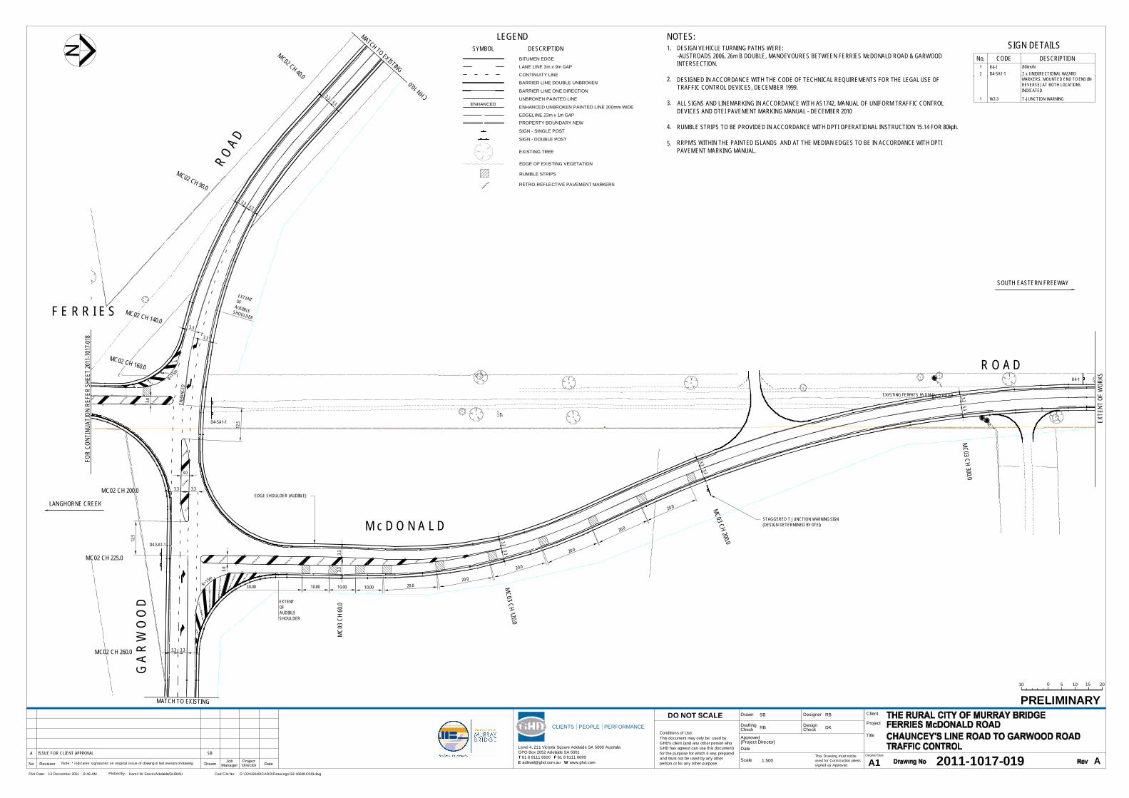
This Drawing must not beused for Construction unlesssigned as Approved
Date
CheckDrafting
DateDrawnRevisionNo A1Original Size
Title
Project
Client
Check
DesignerDrawn
Scale
DesignConditions of Use.This document may only be used byGHD's client (and any other person whoGHD has agreed can use this document)for the purpose for which it was preparedand must not be used by any otherperson or for any other purpose.
DO NOT SCALE
Note: * indicates signatures on original issue of drawing or last revision of drawing
CLIENTS PEOPLE PERFORMANCE
Level 4, 211 Victoria Square Adelaide SA 5000 AustraliaGPO Box 2052 Adelaide SA 5001T 61 8 8111 6600 F 61 8 8111 6699E [email protected] W www.ghd.com
Plot Date: Cad File No:13 December 2011 - 8:48 AM G:\33\16049\CADD\Drawings\33-16049-C019.dwgPlotted by: Kamil W Stock/Adelaide/GHD/AU
(Project Director)Approved
JobManager
ProjectDirector
PRELIMINARY
2011-1017-019 A
SB RB
RB DK
1:500A SB
SOUTH EASTERN FREEWAY
LANGHORNE CREEK
010 5 10 2015
FOR
CONT
INUA
TION
REF
ER S
HEET
2011
-1017
-018
EXTE
NT O
F W
ORKS
MATCH TO EXISTING
MATCH TO EXISTING
F E R R I E S
M c D O N A L D
R O A D
G A
R W
O O
D
R O A
D
3.33.3
MC03 CH 300.0
3.33.3
MC03 CH 200.03.33.3
MC03 CH 120.0
3.33.3
MC0
3 CH
60.0
3.33.3MC02 CH 260.0
3.33.3
MC02 CH 90.0
3.3
3.3
MC02 CH 40.0
3.3
MC02 CH 140.0
3.3
3.33.3MC02 CH 200.0
12.5
12.5
3.0
3.0
D4-SA1-1
D4-SA1-1
STAGGERED T JUNCTION WARNING SIGN(DESIGN DETERMINED BY DTEI)
MC02 CH 225.0
CODE DESCRIPTION
SIGN DETAILSNo.
80km/hr2 x UNIDIRECTIONAL HAZARDMARKERS, MOUNTED END TO END (INREVERSE) AT BOTH LOCATIONSINDICATED
T-JUNCTION WARNINGW2-31
D4-SA1-12R4-11
CHN 10.0
LEGEND
BITUMEN EDGE
LANE LINE 3m x 9m GAP
CONTINUITY LINE
BARRIER LINE DOUBLE UNBROKEN
UNBROKEN PAINTED LINE
EXISTING TREE
EDGE OF EXISTING VEGETATION
PROPERTY BOUNDARY NEW
SYMBOL DESCRIPTION
BARRIER LINE ONE DIRECTION
EDGELINE 23m x 1m GAP
ENHANCED UNBROKEN PAINTED LINE 200mm WIDEENHANCED
SIGN - SINGLE POST
SIGN - DOUBLE POST
DESIGN VEHICLE TURNING PATHS WERE:-AUSTROADS 2006, 26m B DOUBLE, MANOEVOURES BETWEEN FERRIES McDONALD ROAD & GARWOODINTERSECTION.
DESIGNED IN ACCORDANCE WITH THE CODE OF TECHNICAL REQUIREMENTS FOR THE LEGAL USE OFTRAFFIC CONTROL DEVICES, DECEMBER 1999.
ALL SIGNS AND LINEMARKING IN ACCORDANCE WITH AS1742, MANUAL OF UNIFORM TRAFFIC CONTROLDEVICES AND DTEI PAVEMENT MARKING MANUAL - DECEMBER 2010
RUMBLE STRIPS TO BE PROVIDED IN ACCORDANCE WITH DPTI OPERATIONAL INSTRUCTION 15.14 FOR 80kph.
RRPM'S WITHIN THE PAINTED ISLANDS AND AT THE MEDIAN EDGES TO BE IN ACCORDANCE WITH DPTIPAVEMENT MARKING MANUAL.
NOTES:1.
2.
3.
4.
5.
30.00
3.0
10.00 10.00 10.00 20.020.0
20.0
20.0
20.0
20.0
EXTENTOFAUDIBLESHOULDER
EDGE SHOULDER (AUDIBLE)
EXTENTOFAUDIBLESHOULDER
MC02 CH 160.0
RUMBLE STRIPSR=1
5m
R=15m
RETRO-REFLECTIVE PAVEMENT MARKERS
R4-1
ENHA
NCED
ISSUE FOR CLIENT APPROVAL


3533/16049/47868 Ferries McDonald RoadTraffic Management Plan
Appendix E
Log Book Template

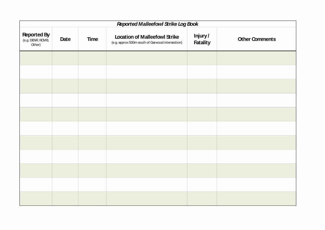
Reported By(e.g. DENR, RCMB,
Other)Date Time Location of Malleefowl Strike
(e.g. approx 500m south of Garwood intersection)
Injury /Fatality Other Comments
Reported Malleefowl Strike Log Book


3633/16049/47868 Ferries McDonald RoadTraffic Management Plan
Appendix F
Roadside Inspection Checklist


3733/16049/47868 Ferries McDonald RoadTraffic Management Plan
Road and Roadside InspectionFor Dead or Injured Malleefowl
Ferries McDonald Road, Monarto South
Section of Road Inspected:
Road Verge Observed: (5m either side of Road) Yes No
Name(s) of Person(s) Observing: Contact:
Organisation: (e.g.RCMB)
Date of Observation:
Start Time of Observation:
End Time of Observation:
Speed Maintained (<25km/h) while Observing: Yes No
Other Specify: ____
Malleefowl Observed: Location: ______________________________
Injured Malleefowl Observed: Location:___________________
Collected immediately and transported to appropriatecare (refer to Injured and Killed Animals protocol)
Reported to DENR
Deceased Malleefowl Observed: Location:________________
Collected Immediately
Preserved Specify:___________________
Submitted to South Australian Museum (SAM)