tropical rainfall measuring mission trmm: data products ... · tropical rainfall measuring mission...
TRANSCRIPT

Tropical Rainfall Measuring Mission TRMM: Data Products and Usage
NASA Remote Sensing Training
Norman, OK June 19-20, 2012
ARSET Applied Remote Sensing Training A project of NASA Applied Sciences

NASA Earth Observing Satellites
Tropical Rainfall Measuring Mission TRMM
h3p://trmm.gsfc.nasa.gov/

What Is TRMM? The first satellite mission dedicated to measuring tropical and subtropical rainfall A collaborative mission between NASA and Japanese space agency Launched on 27 November 1997 Approximate dimensions: 2.4m x 2.4m x 4.4m Approximate weight: 3,500kg

Why TRMM ? Because: accurate measurements of rain are crucial -- rain is extremely important for weather, climate, and energy cycle of the earth tropical rainfall, plays a critical role in driving atmospheric motion releasing latent heating -- 2/3rd of the global rainfall occurs in the tropics
information on intensity and amount of rainfall in the tropics was incomplete – especially over oceans prior to satellite coverage
Rain gauge coverage over Land

TRMM Satellite and Orbits - TRMM is in a non-polar, low
inclination orbit launched at the altitude of approximately 350 Km
- The Orbit was raised to 403 Km after 23 August 2001
- There are 16 TRMM orbits a day, approximate period of 92 minutes, covering global tropics
- TRMM provides global coverage between 35° S to 35°N latitudes
-
TRMM’s low orbital inclination—just 35° from the equator—allows its instruments to concentrate on the tropics. This image shows one half of the observations TRMM makes in a single day.

TRMM Instruments Precipitation Radar (PR) (First rainfall sensing radar in Space)
TRMM Microwave Imager (TMI)
Visible and Infrared Scanner
(VIRS)
Clouds and Earth Radiant Energy System (CERES)
Lightening Imaging Sensor (LIS)
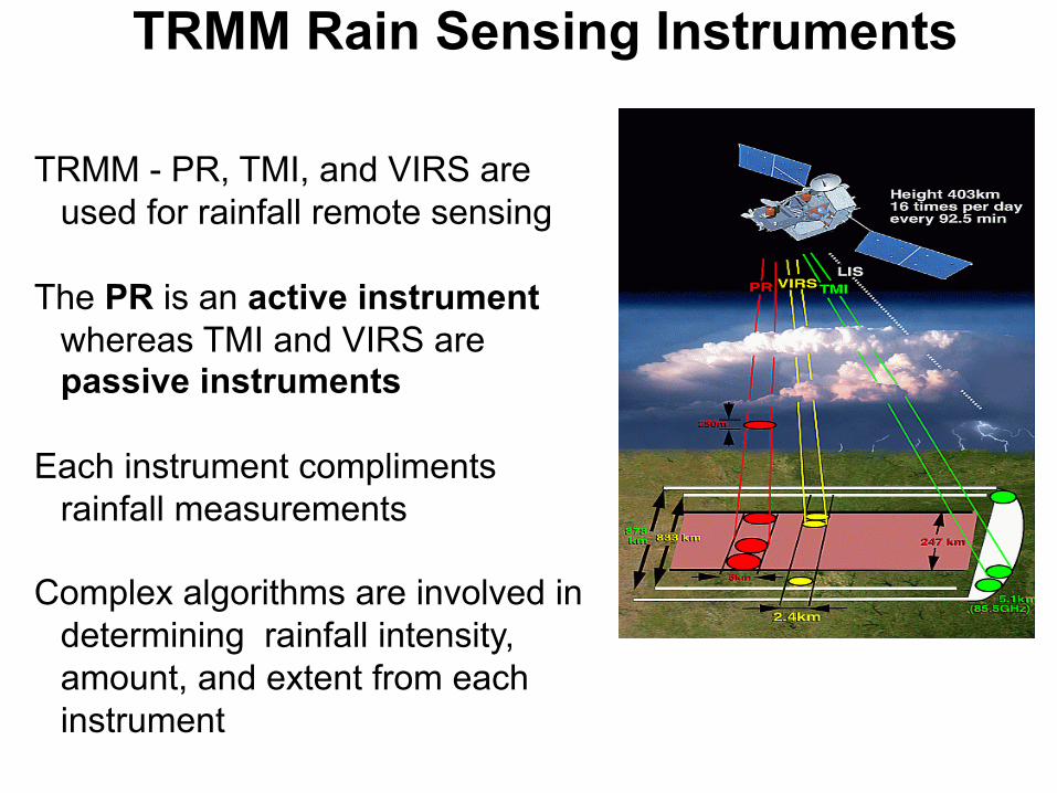
TRMM Rain Sensing Instruments TRMM - PR, TMI, and VIRS are
used for rainfall remote sensing The PR is an active instrument
whereas TMI and VIRS are passive instruments
Each instrument compliments
rainfall measurements Complex algorithms are involved in
determining rainfall intensity, amount, and extent from each instrument

TRMM Precipitation Radar (PR) • First space borne instrument to provide
three-dimensional maps of storm structure and provide a quantitative rainfall measurement over ocean and land (frequency 13.8 GHz)
• 247 km swath width x 5 km instantaneous field of view
• Can provide vertical profiles of rain and snow from the surface to 20 km
• Can detect rain as little as 0.7 mm per hour
• A radar frequency about three times higher than that of ground radar provides good resolution and higher quality images
TRMM PR Reflectivity Hurricane Irene
Vertical profiles

Rainfall Products from TRMM PR
Level 1 & 2: Orbital Data Swath: 220 km (247 km after orbit change) Resolution: 4-5 km horizontal, 250 m vertical Data Format: Compressed HDF Name Quantity 1B21 Radar Power 1C21 Radar Reflectivity 2A21 Radar Surface Cross Section 2A23 Radar Rain Characteristics
(rain type, storm, freezing, and bright band heights) 2A25 Radar Rain Rate, Reflectivity, and Attenuation
Profile

Rainfall Products from TRMM PR
Level 3: Gridded Data Resolutions: - 0.5°x0.5° and 5°x5° latitude-longitude
(for a latitude band from 40°N to 40°S) - Monthly
- 2, 4, 6, 10, 15 km vertical levels Data Format: Compressed HDF Name Quantity 3A25 Total and conditional Rain Rate, Radar
Reflectivity, path-integrated attenuation for rain Type, Freezing and Bright Band Heights, and Snow-ice Layer Depth
3A26 Rain Rate Probability Distribution at
surface, 2 km, and 4 km
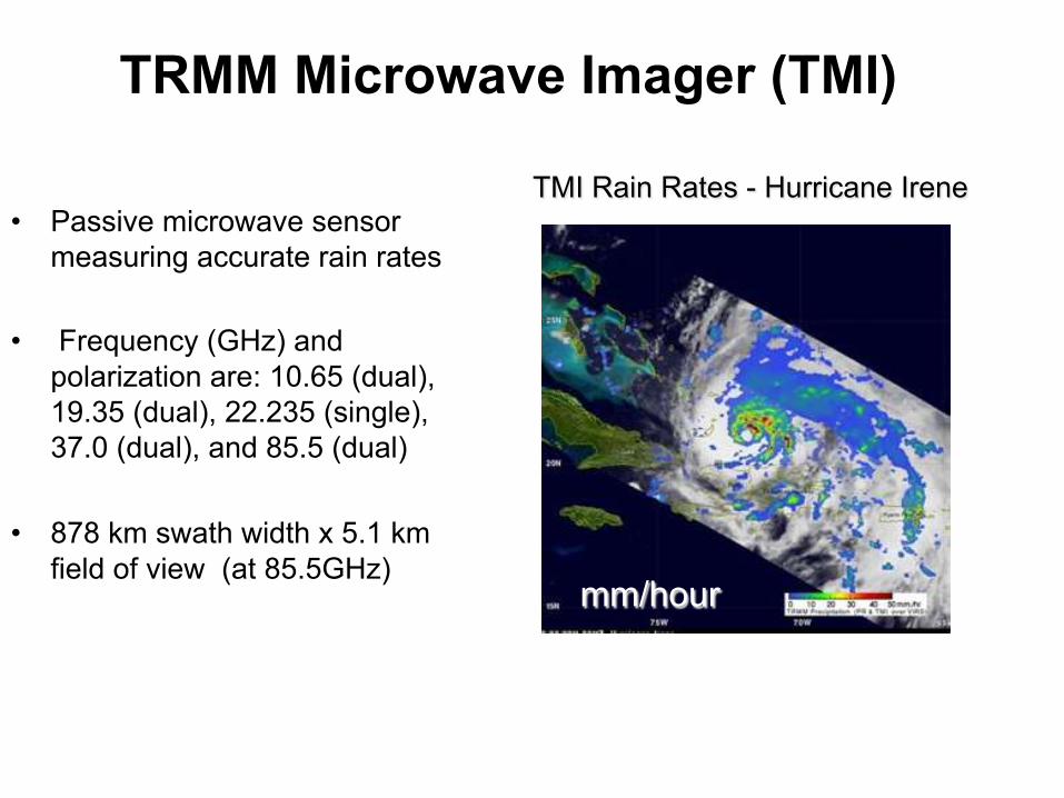
TRMM Microwave Imager (TMI)
• Passive microwave sensor measuring accurate rain rates
• Frequency (GHz) and polarization are: 10.65 (dual), 19.35 (dual), 22.235 (single), 37.0 (dual), and 85.5 (dual)
• 878 km swath width x 5.1 km field of view (at 85.5GHz)
TMI Rain Rates - Hurricane Irene
mm/hour

Rainfall Products from TRMM TMI
Level 1 & 2 : Orbital Data Swath: 760 km (870 km after orbit boost) Resolution: 5 to 45 km horizontal (channel dependent),
14 vertical levels up to 18 km Data Format: Compressed HDF Name Quantity 1B11 Microwave Radiances and Brightness Temperatures with Geolocation Information 2A12 Hydrometeor (cloud, rain, ice/snow particles) Profiles, Latent Heating Profiles
Rainfall Products from TRMM TMI
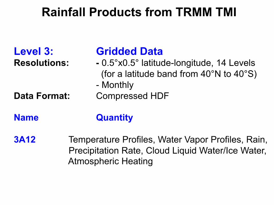
Level 3: Gridded Data Resolutions: - 0.5°x0.5° latitude-longitude, 14 Levels
(for a latitude band from 40°N to 40°S) - Monthly
Data Format: Compressed HDF Name Quantity 3A12 Temperature Profiles, Water Vapor Profiles, Rain,
Precipitation Rate, Cloud Liquid Water/Ice Water, Atmospheric Heating
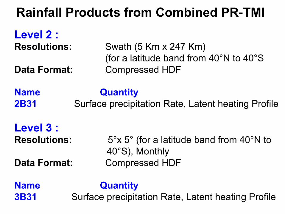
Rainfall Products from Combined PR-TMI
Level 2 : Resolutions: Swath (5 Km x 247 Km)
(for a latitude band from 40°N to 40°S Data Format: Compressed HDF Name Quantity 2B31 Surface precipitation Rate, Latent heating Profile Level 3 : Resolutions: 5°x 5° (for a latitude band from 40°N to 40°S), Monthly Data Format: Compressed HDF Name Quantity 3B31 Surface precipitation Rate, Latent heating Profile

Visible and InfraRed Scanner (VIRS)
• Measures radiation emitted from Earth in 5 spectral regions, visible to infrared (0.63 to 12 µm)
• 833 km swath width x 2.4 km FOV
• Delineates rainfall and helps calibrate TRMM measurements with those of Polar Orbiting Environmental Satellites (POES) and Geostationary Operational Environmental Satellites (GOES)
Hurricane Hanna (9-1-2008) PR & TMI over VIRS
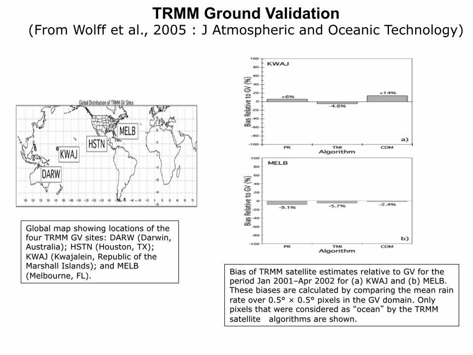
Global map showing locations of the four TRMM GV sites: DARW (Darwin, Australia); HSTN (Houston, TX); KWAJ (Kwajalein, Republic of the Marshall Islands); and MELB (Melbourne, FL).
TRMM Ground Validation (From Wolff et al., 2005 : J Atmospheric and Oceanic Technology)
Bias of TRMM satellite estimates relative to GV for the period Jan 2001–Apr 2002 for (a) KWAJ and (b) MELB. These biases are calculated by comparing the mean rain rate over 0.5° × 0.5° pixels in the GV domain. Only pixels that were considered as “ocean” by the TRMM satellite algorithms are shown.

Comparisons of the TMI, PR, and COM mean rain intensities vs the mean rain intensities of the GV radar at MELB. Rain-rate profiles for (top left) all matched data points; (top right) ocean only, (bottom left) land only, and (bottom right) coast only. (based on 1999-2004 data]
TRMM Ground Validation (From Wolff and Fisher, 2008 : J Atmospheric and Oceanic Technology)
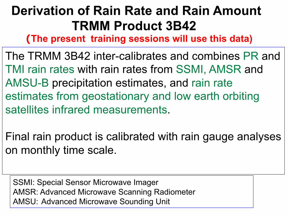
Derivation of Rain Rate and Rain Amount TRMM Product 3B42 (The present training sessions will use this data)
The TRMM 3B42 inter-calibrates and combines PR and TMI rain rates with rain rates from SSMI, AMSR and AMSU-B precipitation estimates, and rain rate estimates from geostationary and low earth orbiting satellites infrared measurements. Final rain product is calibrated with rain gauge analyses on monthly time scale.
SSMI: Special Sensor Microwave Imager AMSR: Advanced Microwave Scanning Radiometer AMSU: Advanced Microwave Sounding Unit

Combined microwave precipitation estimate for the 3-h period centered at 0000 UTC 25 May 2004 in mm h1. Blacked-out areas denote regions that lack reliable estimates, while the zero values in the remaining areas are color-coded to depict the coverage by the various sensors. The order of precedence for display and corresponding zero color are TMI (white), SSM/I (light gray), AMSR-E (medium gray), and AMSU-B (dark gray). (In the TMPA the TMI, SSM/I, and AMSR-E are averaged where overlaps occur.)
The TRMM Multi-satellite Precipitation Analysis – Combined Microwave Estimates
(From Huffman et al. 2006, J. of Hydrometetorology)

TRMM Multi-satellite Merged Prodcut
Level 3: Gridded Data Resolutions: - 0.25°x0.25° latitude-longitude
(for a latitude band from 50°N to 50°S) - 3-hourly, Daily, Monthly
Data Format: Compressed HDF Name Quantity 3B42 3-hourly and daily rain rates 3B43 Monthly averaged rain rates Monthly climatology and anomalies

Obtain TRMM Products All the TRMM products (Level-1 , -2, and -3) can be downloaded from http://mirador.gsfc.nasa.gov by a keyword search. Also, can search by time and location/region

TRMM and Multi-satellite Merged Products 3B42 and 3B43 On-line Visualization and Analysis Can be Conducted on:
http://disc.sci.gsfc.nasa.gov/giovanni/

TRMM Data for Global Climate
Mean Rain Rate (mm/hours) Jan1998-Jun2011
Monthly Accumulated Tropical Mean Rain (mm)
Note the decreasing and increasing nature of the tropical-subtropical rainfall
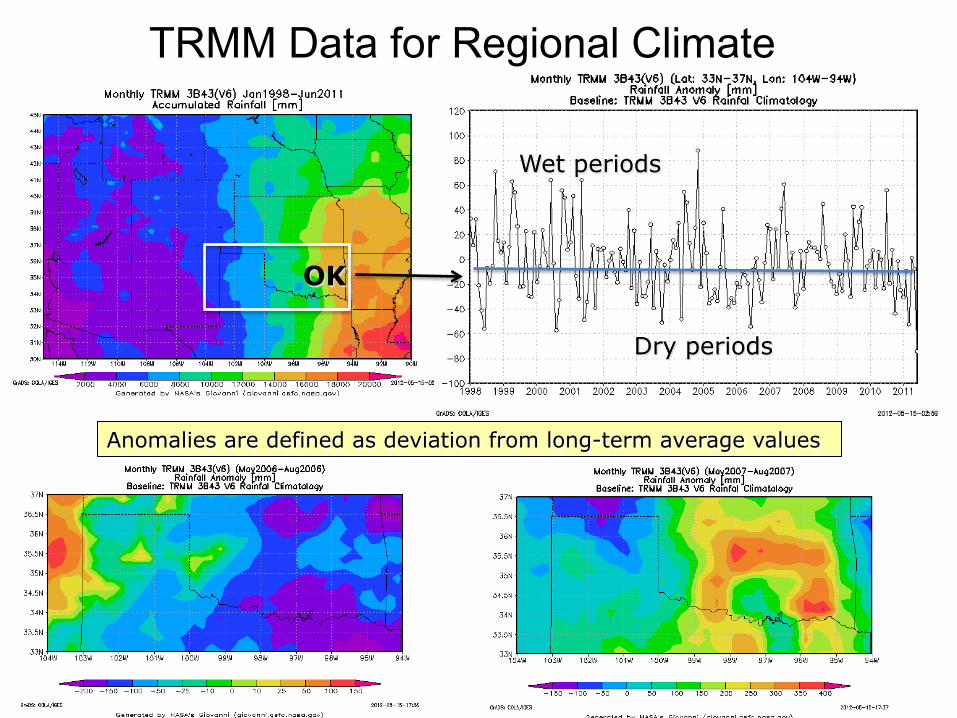
TRMM Data for Regional Climate
Dry periods
Wet periods
Anomalies are defined as deviation from long-term average values
OK

TRMM for Weather
Extreme Rain Event of June 20, 2007
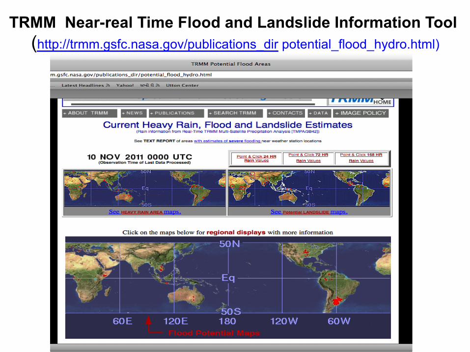
TRMM Near-real Time Flood and Landslide Information Tool (http://trmm.gsfc.nasa.gov/publications_dir potential_flood_hydro.html)

TRMM Precipitation Radar (PR) Technological Challenges
The spaceborne radar requires enough power to detect the weak return echo from the rain drops when seen from TRMM's orbital height High resolution three-dimensional maps of the rain during the brief time that the satellite overflies local storms. The spaceborne radar needs to produce a narrow radiating beam so that the target area would be small enough to bring out the features of interest on the ground- that is, good ground resolution.
Make the beam sweep out a path on the ground that would be
wide enough to give good coverage as the satellite moves along its orbit.

The availability of multiple rainfall products from the various TRMM rainfall sensors is due to the fact that each one has various strengths and weaknesses.
The "best" rainfall estimate is application dependent. The TRMM PR provides the highest spatial resolution (~4 km), the best vertical resolution (80 levels), but has the swath width 1/3rd of the TMI swath width resulting is poorer sampling.
TRMM Rain Sensing Instruments

TRMM Rainfall products