uavs and close range photogrammetrygis.unbc.ca/wp-content/uploads/2013/05/uav-tennant-457.pdf ·...
TRANSCRIPT

UAVs and Close Range Photogrammetry
GEOG457/657 Advanced Remote Sensing
Christina Tennant J.R. Canadian Mapping Ltd.

www.jrcanmap.com
J.R. Canadian Mapping Ltd.
#314 1717 3rd Ave
Prince George, BC, V2L 3G7
250-561-2455

X8 Fixed Wing
Built and maintained by JRCanMap using off-the- shelf components
• Material: EPO foam
• Wingspan: 2.1 m
• Weight: 5 kg
• Power: LiPo Battery
• Flight Time: 90 min


• Pre-programed on the ground and capable of fully autonomous flight from launch thru to landing
• Can capture roughly 1000ha at 10cm pixel resolution, or…
…50ha at 1cm pixel resolution in a single flight
• RGB and Multispectral (RG + NIR) cameras

An Unmanned Aerial Vehicle (UAV) is “a power driven aircraft, other than a model aircraft, that is operated without a flight crew member on board.”
“…are operated by research institutions and other organizations for non-recreational purposes.”
-Section 101.01 of the Canadian Aviation Regulations (CARs)

Types of UAVs
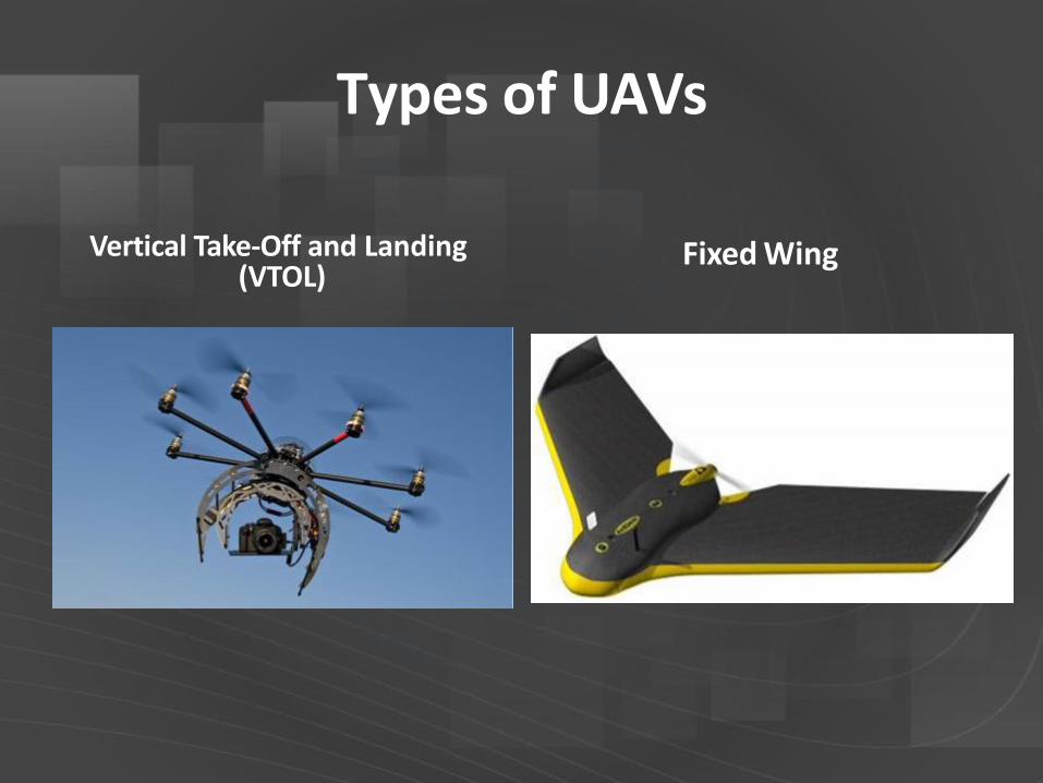
Types of UAVs
Vertical Take-Off and Landing (VTOL)
Fixed Wing

Types of UAVs
VTOL Fixed Wing
Speed Slow Fast
Range Short Long
Take-Off/Landing Area
Small Large
Turning Distance None Long
Flight Direction Any Forward
Mechanical System Complex Simple

Sensors DSLR Camera Thermal
LiDAR Others (e.g. Multispectral)

Transport Canada Regulations
• Unaided Visual Line of Sight (LOS)

Transport Canada Regulations
• Unaided Visual Line of Sight (LOS)
• Ground School Training

Transport Canada Regulations
• Unaided Visual Line of Sight (LOS)
• Ground School Training
• Insurance

Transport Canada Regulations
• Unaided Visual Line of Sight (LOS)
• Ground School Training
• Insurance
• Relevant Acts, Regulations, or Laws
• The Charter of Rights and Freedoms,
• Criminal Code of Canada;
• Privacy Act;
• Personal Information Protection and Electronic Documents Act;
• Customs Act;
• Trespass Act;
• Radiocommunication Act;
• Environmental Protection Act;
• National Parks Aircraft Access Regulations;
• Transportation of Dangerous Goods Act; and
• Canadian Transportation Accident Investigation and Safety Board Act.

Transport Canada Regulations
30 m (or more) away from people, animals, buildings, structures, and vehicles not involved in the operation

Transport Canada Regulations
• Unaided Visual Line of Sight (LOS)
• Ground School Training
• Insurance
• Relevant Acts, Regulations, or Laws
• 30 m (or more) from people/ buildings
• 9 km from airports/forest fires

Resources
• Transport Canada – http://www.tc.gc.ca/eng/civilaviation/standards/gene
ral-recavi-uav-2265.htm
• Unmanned Systems Canada – http://www.unmannedsystems.ca/
• Canadian Centre for Unmanned Vehicle Systems – http://www.ccuvs.com/
• DIY Drones – http://diydrones.com/
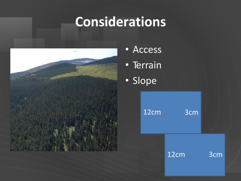
Considerations
• Access
• Terrain
• Slope
3cm
3cm
12cm
12cm

Considerations
• Access
• Terrain
• Slope
• Land Cover

Considerations
• Access
• Terrain
• Slope
• Land Cover
• Weather
• Only What Can be Seen in the Photos


UAV >70% Overlap
UAV >60% Overlap


Post Processing
10% UAV Data Collection, 90% Post Processing
• Photogrammetric stereo workstations
• Advanced in-house and commercial photogrammetric and surveying software
• Experience with the software and associated workflows

Software
• Pix4D
• Agisoft
• Menci
• AreoHawk
• SimActive
• EnsoMosaic UAV
• Triangulate images
• Point Cloud
• DSM
• Ortho
• No automated DEM unless bare earth
• LiDAR software to
process point clouds

Image Matching

Exterior Orientation
Photo Easting Northing Altitude Kappa Phi Omega
DSC06842.JPG 495137 6020698 985.198 111.080 5.316 0.871
DSC06843.JPG 495110 6020691 986.453 114.967 1.418 -4.688
DSC06844.JPG 495083 6020682 987.632 114.053 1.587 -6.506
DSC06845.JPG 495055 6020674 988.814 113.321 1.707 -3.920
DSC06846.JPG 495028 6020666 989.975 112.620 1.501 0.160


Products
• Photography (RGB/NIR)


Products
• Photography (RGB/NIR)
• True Orthomosaics


Satellite-Google Earth

Full Scale Airphoto – 20cm

UAV photo – 3cm

Products
• Photography (RGB/NIR)
• True Orthomosaics
• Point Clouds

Products
• Photography (RGB/NIR)
• True Orthomosaics
• Point Clouds
• Digital Surface Models (DSM)

Products
• Photography (RGB/NIR)
• True Orthomosaics
• Point Clouds
• Digital Surface Models (DSM)
• Digital Elevation Models (DEM)

Products
• Photography (RGB/NIR)
• True Orthomosaics
• Point Clouds
• Digital Surface Models (DSM)
• Digital Elevation Models (DEM)
• Stereo Models

Products
• Photography (RGB/NIR)
• True Orthomosaics
• Point Clouds
• Digital Surface Models (DSM)
• Digital Elevation Models (DEM)
• Stereo Models
• Planimetric Data/Contours

Volumes

Drainage

Slope

Wildlife Monitoring

Vegetation and Habitat


Tree Inventory
• 130 ha
• Mature stand
• Balsam and Spruce

Elevation Data

Dead Standing Trees

Automated Tree Heights

Tree Inventory

Benefits
• Safe
• Data Over Inaccessible Sites
• Minimal Disturbance
• Cost-Effective
• Less Field Time
• Accurate
• Variety of Products
• Snapshot in Time