ud-4c: ground penetrating radar gpr processing and analysis
TRANSCRIPT

1
UD4c
MEMAG A.A. 2020-2021
UD-4c: Ground Penetrating Radar
GPR – processing and analysis
A.A. 2020-2021
Corso di Laurea Magistrale in GEOSCIENZE
Metodi Elettromagnetici in Geofisica (6 CFU) - MEMAG -
Docente: Emanuele Forte
Tel. 040/5582271-2274
e-mail: [email protected]

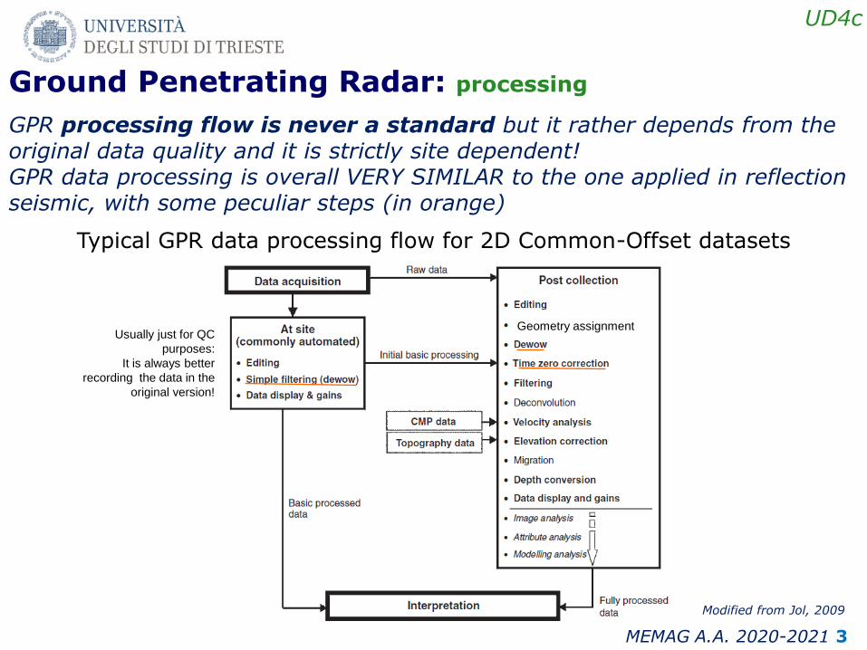
2
UD4c
MEMAG A.A. 2020-2021
GPR data usually cannot be interpreted on the field because require a dedicated processing including a few or even many different algorithms applied in cascade PROCESSING FLOW.
Some definitions: -Processing refers to one or more algorithms which modify irreversibly the data after the application. - Analysis refers to a reversible procedure applied to better evaluate specific characteristics of the data. Often analysis is applied before a corresponding processing step (e.g. frequency analysis before frequency filtering). - Geophysical data inversion is a mathematical technique for recovering information on subsurface physical properties from observed geophysical data. About processing let always remember that (Jol, 2009):
- Keep it simple (also depending by the original data quality and objectives of the survey) - Keep it real Informative data instead of “looking good data”!
- Understand what you are doing - Be systematic and consistent
Ground Penetrating Radar: processing, analysis, inversion
3
UD4c
MEMAG A.A. 2020-2021
Ground Penetrating Radar: processing
GPR processing flow is never a standard but it rather depends from the original data quality and it is strictly site dependent! GPR data processing is overall VERY SIMILAR to the one applied in reflection seismic, with some peculiar steps (in orange)
Typical GPR data processing flow for 2D Common-Offset datasets
Modified from Jol, 2009
Geometry assignment Usually just for QC
purposes:
It is always better
recording the data in the
original version!

4
UD4c
MEMAG A.A. 2020-2021
Ground Penetrating Radar: editing
Editing refers to all the (simple) algorithms applied to correct/cancel out specific data distortions or problems (e.g. spikes, clipped data, repeated traces, dead traces, …). Even apparent small problems have to be “solved” at this stage in order to introduce later on possible artifacts and/or distorting the data interpretation

5
UD4c
MEMAG A.A. 2020-2021
Ground Penetrating Radar: dewow
Wow effect is related to a DC noise component, i.e. a very low frequency trend typical of GPR measurements . It is caused by the swamping or saturation of the recorded signal by early arrivals (i.e., ground/air wave) and/or inductive coupling effects. De-wowing is a vital step as it reduces the data to a mean zero level and, therefore, allows positive–negative color filling to be used in the recorded traces (Figure 5.3). If applied incorrectly, the data will contain a decaying, low-frequency component that distorts the spectrum of the whole trace.
Butler, 2005

6
UD4c
MEMAG A.A. 2020-2021
Ground Penetrating Radar: dewow
The easier way to remove the DC component is just to remove the mean samples value within a window usually centered at the end of the trace where the signal is components are negligible. Another possible strategy is to apply an high frequency bandpass filter.

7
UD4c
MEMAG A.A. 2020-2021
Ground Penetrating Radar: filtering (background noises)
GPR data are often affected by ringing phenomena occurring especially in lossy materials. In such environments, strong antenna–ground coupling and shallow near surface layers can cause significant reverberation in the signal that can mask signals.
Butler, 2005

8
UD4c
MEMAG A.A. 2020-2021
Ground Penetrating Radar: filtering (background noises)
Background noises can be canceled out exploiting the constant arrival times and amplitude subtraction of the mean value calculated over a long
enough trace windows sample by sample or for a few sample length.
Frequency filters don’t work efficiently since the signal and background noise components are superimposed and very similar.
Signal and/or background noise?
DC noise

9
UD4c
MEMAG A.A. 2020-2021
Ground Penetrating Radar: filtering
Temporal vs Spatial In general, filters can be classified into two basic types: temporal (down the individual traces in time) or spatial (across a number of traces in distance). These are often combined to produce advanced 2D filters that operate on the data in both time and space simultaneously.
Time vs frequency domain Frequency filters are good only for removing noise at frequencies either higher or lower than the main GPR signal bandwidth. If a too narrow pass region is selected, then the filter will remove components of the actual recorded signal and the resultant GPR section will have less informative content than the original one. On the other hand time domain filters can discriminate only by using amplitudes, while spectral components are not exploited.
Unfiltered After BP frequency filtering

10
UD4c
MEMAG A.A. 2020-2021
Ground Penetrating Radar: filtering
Jol, 2009
Often combine filters are applied, eventually also space- and time-varying in order to encompass space and time variations, respectively.
Frequency filters are designed with two main analyses referred as: 1) Windowed frequency spectral analysis
2) Filtering scan Special cares have to be considered during frequency filter design in order to minimize Gibbs phenomena related to abrupt limits between pass and canceling zones. Usually a scalene trapezoidal filter shape is adopted.
f1 f2 fc f3 f4 f
A(f)

11
UD4c
MEMAG A.A. 2020-2021
0 5 0 5
Ground Penetrating Radar: filtering
Spectral analysis and fx analysis
fx fx

12
UD4c
MEMAG A.A. 2020-2021
Ground Penetrating Radar: filtering
Filtering scan

13
UD4c
MEMAG A.A. 2020-2021
Ground Penetrating Radar: amplitude recovery
Amplitude recovery is essential in GPR data processing due to the high overall attenuation of EM waves, especially in high loss environments. Different strategies can adopted to recover the amplitude attenuation. Most efficient and physically compliant are: - Inverse of the decay curve - “True amplitude” recovery trying to analytically remove all the attenuation effects but the intrinsic attenuation which is highly informative on the subsurface media.
D(t)
G(t)

14
UD4c
MEMAG A.A. 2020-2021
Ground Penetrating Radar: amplitude recovery
Before amplitude recovery the earlier arrivals are stronger than all the others, while after the recovery all the amplitude are balanced the reflectivity along the same
horizons is almost constant, except where the geology actually changes.

15
UD4c
MEMAG A.A. 2020-2021
When the elevation changes along a GPR profile a “Topographic correction” is mandatory. This is a “static” correction, i.e. constant for each single trace and consists in a time or depth shift proportional to the altitude variations from a predefined DATUM. This approach is accurate enough only when the topographic changes are gradual and the dip of the surface is less than about 10° (Lehmann and Green, 2000). Otherwise additional corrections have to be considered and applied.
Ground Penetrating Radar: topographic correction

16
UD4c
MEMAG A.A. 2020-2021
senttv
s2
)( )cos1(
2
)(
ttvh
ORIGINAL DATA
STATIC CORRECTION
TILTING CORRECTION (h and s components)
FINAL DATA
dx
dz1tanAngle can be estimated for each trace by the equation:
dz is the elevation change between two acquisition points and dx is their distance
MIGRATION
An accurate approach encompasses dedicated imaging and additional terms to the migration algorithm, but this is difficult to apply. Approximated solutions have been proposed (e.g. Forte and Pipan, 2009).
Ground Penetrating Radar: topographic correction

17
UD4c
MEMAG A.A. 2020-2021
Original data
DATUM
STATIC C.
Static correction
TILT “s”
TILT “h”
Tilting correction
1) For =0 both additional tilting components are null 2) For v=cost The correction is constant for all the trac
esamples STATIC For v=v(t)=variable DYNAMIC CORRECTION sen
ttvs
2
)(
)cos1(2
)(
ttvh
Ground Penetrating Radar: topographic correction

18
UD4c
MEMAG A.A. 2020-2021
Ground Penetrating Radar: velocity analysis
When multifold data are available, then different algorithms can be used to estimate the EM velocity field. Most of them are based on the reflection hyperbolas analysis

19
UD4c
MEMAG A.A. 2020-2021
The velocity analysis is essential to obtain correct:
• Topographic/static correction • Depth conversion • True amplitude recovery (spherical
divergence parameterization) • Time/depth imaging • Characterization of the materials
and evaluation of anisotropy and inhomogeneity
For multifold data, integrated velocity
analyses are applied:, including: • Semblance, • Constant Velocity Stack - CVS, • Constant Velocity Gather - CVG, • Direct reflection hyperbolas fitting
Ground Penetrating Radar: velocity analysis

20
UD4c
MEMAG A.A. 2020-2021
5m
Ground Penetrating Radar: velocity analysis
It is therefore possible to reconstruct an accurate and realistic EM velocity field, which gives additional quantitative information and allows a precise depth conversion and imaging.

21
UD4c
MEMAG A.A. 2020-2021
Ground Penetrating Radar: velocity analysis
When just common offset data are available (as in most of the cases!) therefore the only possible strategy to estimate the EM velocity from the data itself exploits the diffraction (i.e. scattering) hyperbolas. Different approaches are used. The simplest are: 1) Hyperbola fitting 2) Migration velocity scan
Several other algorithms have been proposed (and example is provided by Dossi et al., 2020)
Distanza in metri
0.0 1.0 2.0-2.0 -1.0
1ns
2ns
3ns
4ns

22
UD4c
MEMAG A.A. 2020-2021
OB
BD'tan
sentan
OB
BDsen
Here, for simplicity we consider reflections of rays produced by a co-located source (T) and receiver (R)
Ground Penetrating Radar: migration
T1, R1 T2, R2
Considering the triangle ODB and the sine definition:
Considering the triangle OD’B and the tangent definition:
Therefore:
Migration algorithms are one of the most crucial steps in GPR (and reflection seismics) processing because they are essential to recover the actual positions and shapes of the structures Subsurface imaging from P(x,y,z=0,t) to P(x,y,z,t=0)

23
UD4c
MEMAG A.A. 2020-2021
Ground Penetrating Radar: migration
There are a plethora of possible migration algorithms (2D, 3D, in time, in depth, pre- and post-stack,…) but for all of them the most crucial parameter is the accuracy of the estimated EM velocity field.
(a) the preprocessed data prior to migration, and (b) the data after RTM from topography
Bradford_et al., 2018

24
UD4c
MEMAG A.A. 2020-2021
Domande?