uncommon innovation: developments in groundwater ......withdraw a far greater volume of groundwater...
TRANSCRIPT

Uncommon Innovation:Developments in Groundwater Management Planning in CaliforniaBy Rebecca Nelson
Water in the West Working Paper 1 | March 2011
Woods Institute for the Environment | The Bill Lane Center for the American West
Stanford University

i
Uncommon Innovation: Developments in Groundwater Management Planning in California
By Rebecca Nelson*1
Water in the West Working Paper 1
March 2011
Woods Institute for the Environment
The Bill Lane Center for the American West
Stanford University
* Lead Researcher, Comparative Groundwater Law and Policy Program, Woods Institute for the Environment and Bill Lane Center for the American West (Stanford University) and United States Studies Centre (University of Sydney); B.E.(Env.Eng.)(Hons1)/LL.B.(Hons1) (Melb., ’05), J.S.M (Stanford, ’10), J.S.D. Candidate (Stanford, ’13). Contact: [email protected].
This working paper was produced with the support of the U.S. Studies Centre at the University of Sydney, under a doctoral scholarship funded by the Dow Chemical Company Foundation and the Alcoa Foundation. Part of the research occurred as part of a Masters thesis undertaken at the Stanford Law School, supported by the General Sir John Monash Foundation. The insights and comments of Professors Buzz Thompson and Michael Wara are gratefully acknowledged. Errors are those of the author alone.
COVER IMAGES, CLOCKWISE FROM LEFT: DISCOVERY BAY DEVELOPMENT NEAR SAN JOAQUIN DELTA; DRY BED OF LEXINGTON RESERVOIR NEAR LOS GATOS, CA IN 2008; SWANS ON THE SACRAMENTO RIVER DELTA; HOOVER DAM ON THE COLORADO RIVER, NEVADA; WORKING IN MATADERO CREEK, PALO ALTO, CA CREDITS: SARA TOLLEFSON; CHRISTOPHER HYNES; INGRID TAYLAR; ANDREAS METZ; ALAN LAUNER
ii
TABLE OF CONTENTS
Executive Summary ................................................................................................................................... iv
Part One: Introduction ................................................................................................................................ 1
Part Two: Why Manage Groundwater? ..................................................................................................... 2
Part Three: Groundwater Management Planning .................................................................................... 3
1. Overview of water resources planning ............................................................................................... 3
2. Involving stakeholders ........................................................................................................................ 3
3. Collecting information ......................................................................................................................... 4
4. Adopting a portfolio approach to groundwater management strategies ............................................ 4
Part Four: Groundwater Pumpers, Water Agencies, and the Law and Policy of Groundwater Management Planning in California .......................................................................................................... 6
1. What role do groundwater pumpers have in managing groundwater? .............................................. 6
2. Which local water agencies have an interest in managing groundwater? ......................................... 6
3. How do Californian law and policy provide for groundwater management plans? ............................ 7
Part Five: Innovations in Groundwater Management Planning in California ..................................... 10
1. Moving beyond words: Planning for action ...................................................................................... 11
2. Cooperation and stakeholder participation....................................................................................... 17
3. Collecting information about groundwater context ........................................................................... 19
4. A portfolio approach to groundwater management planning ........................................................... 22
4.1 Securing groundwater supply for the long term ...................................................................... 22
4.2 Protecting connected surface waters ...................................................................................... 29
4.3 Restoring ecosystems and minimizing ecological impacts ..................................................... 30
4.4 Considering economic and financial sustainability .................................................................. 31
Part Six: Conclusion and Next Steps ...................................................................................................... 33
iii
References ................................................................................................................................................. 34
TABLE OF FIGURES AND TABLES
Table 1: Examples of governance structures for implementing GWMPs, listed in increasing levels of
formality ....................................................................................................................................................... 11
Table 2: Determining goals and assessing and reporting performance ..................................................... 12
Table 3: Subjects of collaboration between water agencies in GWMPs .................................................... 17
Table 4: Structures for involving stakeholders in GWMPs .......................................................................... 18
Table 5: Avoiding and resolving disputes when formulating and implementing GWMPs ........................... 19
Table 6: Gathering and standardizing information on groundwater status and use ................................... 20
Table 7: Methods of controlling groundwater extraction: limiting waste, groundwater drawdown, or
pumping ....................................................................................................................................................... 22
Table 8: Methods of managing groundwater demand ................................................................................ 25
Table 9: Methods of using different water sources conjunctively ............................................................... 25
Table 10: Methods of protecting and enhancing recharge and examples of water banking ...................... 27
Table 11: Methods of protecting connected surface waters ....................................................................... 29
Table 12: Methods of restoring ecosystems and minimizing ecological impacts ....................................... 30
Table 13: Methods of considering economic and financial sustainability ................................................... 32
Figure 1: Basin Management Objective Information Center for Butte, Tehama, Glenn and Colusa
Counties – screenshot of map interface and individual well information
(http://gis.buttecounty.net/bmoic3/GIs/Default.asp?loadfile=map.asp&county) ......................................... 16
GLOSSARY
DWR Californian Department of Water Resources GWMP Groundwater Management Plan UWMP Urban Water Management Plan

iv
EXECUTIVE SUMMARY
Unusually among western states in the United States, California has no statewide regulation of groundwater allocation or management. Rather, a complicated network of local agencies manages groundwater. The lack of state oversight means that there is little easily accessible information about how these agencies plan for the development and management of groundwater resources. We do know that significant areas of the State suffer from critical conditions of overdraft, where groundwater pumpers withdraw a far greater volume of groundwater than appears to be sustainable. These continually lowering water tables threaten serious economic, social, and environmental harms. Even so, groundwater use is increasing, and is projected to increase at a greater rate in the future.
Over decades, commentators have advocated reforming California’s groundwater laws to alleviate problems of groundwater overdraft. Many suggestions derive useful inspiration from the experience of other States, and sometimes other countries. This report takes a different tack. It draws inspiration from how local agencies currently manage groundwater in California. It analyzes a collection of over 50 local groundwater management plans—most sourced directly from the agencies themselves—to find promising and innovative approaches to local groundwater management. These approaches are organized into four key themes: involving stakeholders, collecting good information, adopting a diverse “portfolio” of approaches to groundwater management, and taking steps to ensure that a plan can be implemented in practice.
Contrary to popular expectations, the report uncovers a treasure trove of innovative strategies for groundwater management in California. Among other things, we see agencies using measurable objectives for limiting groundwater drawdown; analyzing suites of management options with transparent decision criteria and simulations; collaborating with neighboring agencies; involving a broad range of agricultural, municipal, environmental, State, and federal stakeholders in their planning decisions; undertaking groundwater metering as well as monitoring; actively controlling pumping to limit groundwater drawdown; and protecting hydrologically connected surface waters and groundwater-dependent ecosystems. These practices may not be common, but they should be. This report is intended, in part, as a resource for local agencies, to enable these practices to become more widespread.
The home-grown innovations uncovered by this report point the way forward for local agencies to better manage groundwater in California, and the way towards an updated and improved State policy structure to encourage them to do so. Strengthening California’s legislation for groundwater management planning, informed by current best practice, would provide a path towards better groundwater management and retain the State’s historical focus on local agencies driving local change. The local planning actions uncovered by this report are not only innovative, they are also practical, down-to-earth and doable—they are being undertaken by different types of local agencies, with widely varying resources, across the State, right now.

1
PART ONE: INTRODUCTION
Unusually among western states in the United States, California has no statewide regulation of groundwater allocation or management. And although the State Water Resources Control Board has the legal power to prevent the “unreasonable use” of groundwater in the State and to control pumping by initiating adjudications of groundwater rights (Cal. Water Code §§ 2100-2102), it does not exercise that power (Sandino, 2005, p. 478). Instead, by convention, the state refrains from intervening and leaves these matters to local agencies, of which there are many different “species” established under different state statutes.
Commentators have advocated reforming California’s groundwater laws over decades. Their suggestions have ranged from regulating groundwater at the State level (Hanak et al., 2010; Sax, 2003, p. 288; Taylor, 2010), to enforcing and improving prohibitions on wasting water generally (Neuman, 1998), to establishing a groundwater reserve as protection from drought (Langridge, 2009). Many suggestions derive useful inspiration from the experience of other States, and sometimes other countries. But in the short term, wholesale State-level water reform seems a distant prospect.
This report takes a different tack. It draws inspiration from how local agencies currently manage groundwater in California. Based on an analysis of a randomly selected collection of 52 groundwater management plans made by local agencies under Californian law (out of some 130 in total), this report highlights current “best practice” in local groundwater management planning in California. Here, best practice is defined by reference to accepted principles of water resources planning, like collecting adequate information, involving stakeholders, and pursuing multiple goals and strategies.
The innovations presented here are neither common nor representative of groundwater management in California—they are exceptional. Even putting the desirability of longer term reforms aside, these practices chart a path forward for local agencies in California in a way that is innovative, practical, down-to-earth and doable—a path that requires only that Californians look to each other for inspiration.
This report marks the start of a multi-year groundwater research program—part of the Joint Initiative on Water in the West, of the Woods Institute for the Environment and the Bill Lane Center for the American West at Stanford University. As a preliminary step, it does not seek to offer definitive solutions. Rather, it aims to challenge the common view of all groundwater management in California as lawless and backward, by highlighting innovative practice that can help chart a path to reforms which could grow organically from current practice. It also hopes to spur further empirical research on how groundwater management planning activities on paper translate to challenges and successes on the ground, by pointing to selected agencies and areas that show promise.
Part Two of this report sets out key practical and policy rationales for local water agencies to engage in groundwater management, with reference to the effects of overdraft. Part Three describes in more detail what is meant by “groundwater management planning” and presents a vision that defines “best practice” for the purposes of this report. Part Four sets the stage, outlining the roles of groundwater pumpers and local water agencies in managing groundwater in California, and how Californian law and policy provide for groundwater management plans. It suggests that this law and policy is now out of date and in need of reform, when compared to other legal developments in water planning in California. Part Five gives detailed examples of how selected local agencies in California approach groundwater management in an innovative and practical way. Part Six concludes and suggests how the innovations outlined in this report could lead to further policy developments in, and research on, Californian groundwater management.
2
PART TWO: WHY MANAGE GROUNDWATER?
To appreciate the need to manage groundwater, and the responsibilities that local agencies face in doing so, it is necessary to consider how groundwater is used and the consequences of depletion at the ground level. Californians use groundwater primarily for irrigation (around 75%) and municipal and domestic purposes (around 23%) (Kenny & U.S. Geological Survey, 2009, p. 7). Groundwater use is increasing, and is projected to increase at a greater rate as climate change threatens the reliability of surface water supplies (Cal. Dep't of Water Resources, 2008, p. 5).
Even at current rates of use, in some regions of California, groundwater pumpers withdraw a far greater volume of groundwater than appears to be sustainable. The latest state assessment of critical groundwater overdraft in California dates from 1980. It found that 11 basins suffered from “critical conditions of overdraft”, meaning that “continu[ing] present water management practices would probably result in significant adverse overdraft-related environmental, social, or economic impacts”—terms which are defined at the local level (Cal. Dep't of Water Resources, 2003, p. 98).
Economically, water production costs may increase because diminishing groundwater levels mean that more energy is needed to pump water to the surface. It also costs more to treat groundwater that has been affected by quality problems associated with overdraft, such as intruding seawater, saline groundwater, or newly mobilized contaminants (Zekster, et al., 2005, pp. 402-403). At the extreme, impaired quality can render groundwater unusable (Cal. Dep't of Water Resources, 2003, p. 8), and possibly without economic value. Groundwater extraction has caused groundwater levels to decrease by more than 200 feet in some parts of California (U.S. Geological Survey, 2003, p. 3), and ground subsidence affects over half of the San Joaquin Valley (Zekster, et al., 2005, p. 401). This permanently reduces the storage capacity of the aquifer and may damage overlying infrastructure and aggravate seawater intrusion. In some areas, subsidence has resulted in the need for costly flood control infrastructure (Santa Clara Valley Water Dist., 2001, pp. 13, 44).
Intensive groundwater use also represents a powerful potential source of social conflict, although it has certainly provided significant social benefits from economic development (Llamas & Martinez-Santos, 2005). Though there appears to be little sustained work on the social effects of overdraft in California, the economic harms described above naturally have corresponding social effects.
In ecological terms, groundwater depletion may adversely affect connected streams, lakes, wetlands, springs, coastal environments, and the flora and fauna which depend on aquifers directly, or on these connected systems (Alley, et al., 1999, pp. 30-44). The ecological impacts of groundwater overdraft in California include diminished streamflow and lake levels, damaged vegetation, and corresponding effects on fish and migratory birds. Effects are felt at Lake Merced near San Francisco, Redwood Creek in northern California, the Cosumnes River near Sacramento, and the Owens River Valley, to name a few (Zekster, et al., 2005, pp. 398-401).
Groundwater management planning is a key way to prevent and holistically deal with these effects on a vital water supply for farms and cities in California.

3
PART THREE: GROUNDWATER MANAGEMENT PLANNING
Historically, water resource problems were considered “technical challenges to be resolved through purely technical means” (Feldman, 1991, pp. 72-73). A more modern view of water resources management conceives of a much more comprehensive, planning-based approach to water management. Such an approach involves managing all water sources, involving stakeholders, meeting the basic needs of both human water users and the environment, and managing demand through greater efficiency, public education, and incentives to conserve water—in addition to simply augmenting water supplies (Brooks, et al., 2009; Palaniappan & Gleick, 2009, p. 13). This report adopts this holistic understanding of groundwater management and draws out elements of California’s local agency plans that together, build such an approach. Before discussing these local approaches in detail, it is appropriate to consider in greater depth what each element of this holistic vision of groundwater management planning requires.
1. Overview of water resources planning
Water resources planning refers to a process of (Gardner, et al., 2009, p. 273; Gleick, 1998):
systematically gathering information about a water resource, including its status and its environmental, social and economic values;
identifying existing rights and interests; evaluating present and future water needs; setting guidelines for future management; regularly reviewing the plan to ensure it can adapt to changing circumstances; and publicly reporting on the plan’s implementation.
Water planning is particularly important as a way to formally anticipate and deal with variable water availability in arid and semi-arid areas, and as groundwater extraction and resource stress intensify. Although some jurisdictions use water plans as a primary way to control access to groundwater, in California, management plans for groundwater overlay allocation systems founded on common law rights. Groundwater management plans are one type of water management plan among many, including:
the five-yearly State Water Plan, which sets out goals and objectives (Cal. Water Code § 10004); integrated water resources management plans (Cal. Water Code §§ 10530-10550); urban water management plans (Cal. Water Code §§ 10610-10656); and agricultural water conservation programs (Cal. Water Code §§ 10520-10523).
Whether or not they have legal force, plans are “the basic instrument for ensuring the rational management of the water resources available” (Caponera, 2007, p. 137; Sax, 2003, p. 317).
2. Involving stakeholders
Public participation has been a feature of water planning in the United States for decades, though its implementation has not always been uncontroversial (Wengert, 1971). The two key issues are who to consult, and what role they should play. It is increasingly recognized that in water matters, “everyone is a stakeholder”, including disadvantaged groups, individuals, non-government entities, and local groups of all kinds (Global Water Partnership Technical Advisory Comm., 2000, pp. 15-17; Iza & Stein, 2009, p. 86). Stakeholders should make “significant contributions to outcomes”, rather than merely “legitimize decisions already made” (Bergkamp, et al., 2009, p. 39; Global Water Partnership Technical Advisory Comm.,

4
2000, pp. 15-17). For example, in the groundwater sphere, stakeholders should be involved in “decid[ing] the specific conditions under which the undesirable consequences [of groundwater depletion] can no longer be tolerated” (Alley, et al., 1999, p. 76). Formal advisory committees of stakeholders assist local water agencies by providing a variety of perspectives, reducing future conflicts, achieving local buy-in, and broadening the discussion beyond purely operational issues (City of San Diego Water Dep't, 2007, pp. 3-18).
3. Collecting information
Pumping groundwater without monitoring extraction or the state of the aquifer has been compared to a business continually withdrawing money from a bank account without any bookkeeping system (U.S. Geological Survey, 2003, p. 4). Indeed, the Californian Legislature itself acknowledges that information about groundwater is required to properly manage the resource (Cal. Water Code § 10750(b)). The most fundamental data for groundwater management relates to groundwater levels, quality, extraction (Taylor & Alley, 2001, p. 1), and the health of dependent ecosystems. When local agencies require well owners to register and meter their wells, and report groundwater extraction, they gain crucial information about the stress on the resource and the wider local impacts of depletion, for example, ground subsidence. When they also collect ecological information—information that may initially seem outside their “mission”—they gain the ability to manage the resource for broader and longer-term sustainability, beyond a narrow focus on short-term water supply goals.
4. Adopting a portfolio approach to groundwater management strategies
A portfolio approach to groundwater management, as presented here, has two key characteristics—it involves multiple goals, and it involves using multiple strategies to pursue each goal. Traditionally, local water agencies in California focus on a narrow portfolio of goals. They focus very strongly on groundwater supply for consumptive purposes, often to the exclusion of other goals, like maintaining or restoring ecosystems, protecting connected surface waters, or ensuring that groundwater use minimizes third-party impacts on society.
Historically, California has also preferred engineering solutions to water problems over other approaches, and to some extent, this remains true, unnecessarily impoverishing California’s portfolio of water management strategies (Hanak, et al., 2010, p. 25). Rather than seeking a “silver bullet”, water problems are better approached with a portfolio of strategies (Hanak, et al., 2010, p. 34). Although the local context will determine which strategies are likely to be effective, empirical evidence suggests that having a larger and more diverse suite of water management actions is likely to enhance overall effectiveness and robustness; redundancy can encourage greater compliance because different users will respond to different approaches and increase “complementarity”, whereby different approaches reinforce each other (Cash, 2006, p. 285).
Water resources literature is filled with different methods of dealing with managing groundwater to control depletion. Given the historical emphasis on engineered, supply-side solutions, this report focuses on how local Californian agencies manage groundwater demand using voluntary and mandatory measures; infrastructure measures are covered to a lesser degree, with an emphasis on the conjunctive management context, as described below.
A mandatory approach to demand management involves limiting extraction to a target level by mandating reductions in existing pumping, limiting the construction of new wells, or requiring conservation measures. Ideally, the target extraction level should avoid irremediable impacts on immediate and downstream freshwater ecosystems and maintain their integrity; consider links with water quality; and include

5
“measures aimed at coping with droughts”, such as a drought reserve, given that groundwater is often required as a buffer against drought (Dellapenna, 2004, pp. 89, 90; Flint, 2004, pp. 41, 47; Nevill, 2009, p. 2627). Since mandatory measures often encounter strong opposition from existing and aspiring rights-holders; limits should be set well before extraction approaches those levels (Nevill, 2009, p. 2628).
A voluntary approach to demand management entails using fees, educational measures or water efficiency projects to reduce groundwater pumping. The fee-based approach entails charging private well owners fees for groundwater extraction. In theory, the economic value of water comprises both its market value and its “non-market values to human capital and ecosystem service values” (Lant, 2007, p. 64). In practice, realizing this vision through fees is difficult—it is far easier to leave out or under-account for costs that are difficult to calculate, like the costs of “servicing the regulatory framework, environmental degradation, forced social change, impacts on future generations and this generation in the future” (Connell, 2007, p. 31). One method of introducing fees while reducing resistance and encouraging conservation is to use tiered charges, or allow users to pump a certain volume free of charge (Schiffler, 1998, p. 171).
Infrastructure measures entail either constructing or changing the operation of existing infrastructure. Infrastructure measures include reducing demand for local groundwater by treating and recycling wastewater or importing water from other basins. However, it must be noted that relying heavily on imported surface water may be ecologically damaging to the source area (Langridge, 2009, pp. 317-318). Another infrastructure-related measure is conjunctive management—using surface water and groundwater in a coordinated way, such that surface water is used to recharge groundwater when surface supplies are abundant, and groundwater is used preferentially (“recovered”) in times of shortage. This can involve directly replenishing aquifers using spreading basins, injection wells or riverbeds. While this has obvious advantages, recovering groundwater from storage during a severe drought can compromise connected surface water systems and cause all of the problems of severe overdraft discussed above (Langridge, 2009, pp. 317-318). Alternative solutions include changing the spatial or temporal management of pumping to reduce the intensity of local depletion effects (Alley, et al., 1999, pp. 72-73).
This Part has presented a theoretical vision of holistic groundwater management planning. With this vision in mind, Part Four now examines the law and policy of groundwater management planning in California, before Part Five discusses Californian groundwater management planning in practice.

6
PART FOUR: GROUNDWATER PUMPERS, WATER AGENCIES, AND THE LAW AND POLICY OF GROUNDWATER
MANAGEMENT PLANNING IN CALIFORNIA
Before discussing how Californian law provides for groundwater management plans, this report first sets the stage by presenting answers to two vital preliminary questions. What role do groundwater users have in controlling groundwater? And which local water agencies have an interest in managing groundwater?
1. What role do groundwater pumpers have in managing groundwater?
In most areas, well owners can pump groundwater without holding any administrative permit (Sax, 2003, p. 270). The common law doctrine of correlative rights regulates the taking and use of groundwater, unless local arrangements apply. That doctrine limits groundwater pumping to the “safe yield”, being the volume of natural and artificial recharge of the aquifer, which is shared by overlying landowners on an “equitable basis” (regardless of their particular uses), and by non-overlying landowners, if there is sufficient water available (Katz v. Walkinshaw, 74 P. 766 (Cal. 1903)).
These common law rules have been heavily criticized as insufficient to properly manage groundwater or control groundwater depletion (Sandino, 2005, p. 479). To limit extraction, they require an individual user to file a lawsuit to settle all the groundwater rights in a basin, a course of action which is expensive and time-consuming (Langridge, 2009), and one which most agencies are very eager to avoid. As a result it is rarely done: adjudications cover only 22 of California’s 431 basins (Cal. Dep't of Water Resources, 2003, p. 106; 2009). Without basin adjudications, “users can continue their use unabated”, and the system may even encourage overpumping (Krieger & Banks, 1962, pp. 61-62; Sandino, 2005, p. 477). Adjudications are also limited thematically, since they cannot regulate groundwater pumping to protect water quality (Cal. Dep't of Water Resources, 2003, p. 40), nor plan for future changes in supply. Finally, some view resolving water disputes adversarially, rather than collaboratively, as inherently “dysfunctional”, a process that “hinders our ability to create win-win outcomes” (Sheer, 2010, pp. 3, 4).
Groundwater management plans can help to address some of the problems with this common law system. In contrast to basin adjudications, groundwater management plans can cover large areas, and can integrate considerations of water quantity and quality, all with an eye to the future. Nonetheless, even with California’s system of voluntary groundwater management plans, if local water agencies do not act, groundwater pumpers have complete management control over the resource, with no higher level of cooperation or rational planning.
2. Which local water agencies have an interest in managing groundwater?
California’s Water Code provides for an astounding array of over 20 general types of local water agencies, which may be established anywhere in the State (Cal. Dep’t of Water Resources, 2003, p.34, Table 32). On the ground, there are around 2300 of these agencies,2 which may have interests in groundwater. These agencies may supply groundwater to their customers, or supply surface water to customers who also use groundwater, or they may wish to protect the resource because they plan to use it as a source of supply in the future. Such agencies include California water districts, county water
2 This number was arrived at by taking the 20 statutes, which the current State Groundwater Bulletin indicates may have groundwater management powers, and noting the number of agencies which fall into these types, as set out in the California Controller’s latest report on special districts (Cal. Dep't of Water Resources, 2003, p. 34; Cal. State Controller, 2010, p. 1061).

7
districts, irrigation districts, reclamation districts, water conservation districts, water replenishment districts, water storage districts, and waterworks districts.
In addition to these general types of agencies, several State acts target specific geographical areas suffering from local groundwater problems by creating special districts with powers tailored to dealing with these problems. Their powers include controlling in-basin pumping in situations of actual or threatened overdraft, limiting exports, spacing wells to minimize well interference, and imposing groundwater-related charges. Some view these districts as “the state-of-the-art in local groundwater management . . . successful in addressing their groundwater problems, and [] useful models to be considered for use in other parts of the state”, while conceding that State-level political will may be insufficient to extend this technique to other overdrafted basins (Sandino, 2005, p. 484). Indeed, sometimes a local water agency is created in the form of a general statutory district (not a special district) to deal with serious groundwater depletion problems, possibly giving force to this view (Turlock Groundwater Basin Assoc., 2008, pp. 33-34). The DWR lacks an oversight function in relation to water management by both local water agencies and also special districts (Cal. Dep't of Water Resources, 2003, p. 33).
As these complicated agency arrangements suggest, a vast range of local agencies has an interest in managing groundwater. This includes many general statutory types of agencies which have varying interests in managing groundwater—as an existing or potential future user, or as a supplier of surface water to customers who also use groundwater. It also includes specially created districts which were established to deal with serious local groundwater problems.
3. How do Californian law and policy provide for groundwater management plans?
In California, statutory arrangements for groundwater management plans overlay the common law allocation system, and allow agencies to manage groundwater more proactively than is possible under common law rules (Hanak, 2003, p. 108; Sandino, 2005, p. 484).
California’s Groundwater Management Act (AB 3030) encourages local-level groundwater management in basins with significant water use, which are not adjudicated (Cal. Water Code §§ 10750(a), 10750.2, 10752(b)). It permits a local agency, which includes a special district or a group of agencies, to adopt and implement a groundwater management plan (GWMP) for all or part of the agency’s service area (Cal. Water Code §§ 10752(g), 10753(a), 10755.2).
Adopting a GWMP involves formal procedural steps, including making specific resolutions, issuing public notices and conducting public hearings (Cal. Water Code §§ 10753.2-10753.6). If landowners representing more than 50 percent of the assessed value of the land within the local agency protest against the GWMP, the local agency may not adopt it (Cal. Water Code § 10753.6). A GWMP may cover 12 enumerated matters. The quantity-related matters are: mitigating conditions of overdraft, replenishing extracted groundwater, monitoring groundwater, facilitating conjunctive use operations, and constructing and operating groundwater recharge, conservation, water recycling, and extraction projects (Cal. Water Code § 10753.8). An agency “shall adopt rules and regulations to implement and enforce” a GWMP (Cal. Water Code § 10753.9(a)).
When a local agency adopts a GWMP, it gains power to manage groundwater that may go beyond its powers under its establishing legislation. First, it may limit or suspend groundwater extractions, provided it “has determined through study and investigation that groundwater replenishment programs or other alternative sources of water supply have proved insufficient or infeasible to lessen the demand for groundwater” (Cal. Water Code § 10753.9). In this context, it is important to note that pumping limits need not amount to a constitutional taking, since groundwater pumpers are restricted to pumping for a

8
reasonable beneficial use (Allegretti & Co. v. County of Imperial, 42 Cal. Rptr. 3d 122 (Cal. App. 2006)). Second, a local agency may impose charges for groundwater extraction or replenishment on the endorsement of a majority of voters (Cal. Water Code § 10754.3). On the other hand, failing to adopt a GWMP makes a water agency ineligible to receive water grants and loans from the state (Cal. Water Code § 10753.7(b)).
Californian law for GWMPs fills the void of comprehensive management that common law rules create, granting California’s complicated web of local water agencies powers to plan and manage local groundwater proactively. But it is now out of date, and does not match up to modern principles of groundwater planning. It emphasizes augmenting supply to the exclusion of managing demand, and does not require local agencies to take any sort of action, even in cases of severe overdraft (Cooley, et al., 2009, p. 11; Hanak, 2003, pp. 107-108). While procedures are set out for amending a GWMP, a local agency is not required to review its GWMP, keep it up-to-date, or even implement it. Indeed, agencies have sometimes adopted GWMPs as a strategy to head off state intervention, without a strong intention to implement them (Hanak, 2003, p. 107).
Almost twenty years of groundwater management planning in California (since 1992) have seen policy on the subject mature. Early GWMPs focused on preventing the export of groundwater from local areas rather than on comprehensive management, and did not focus strongly on implementation (Cal. Dep't of Water Resources, 2003, p. 54). The Legislature responded by requiring greater rigor, directing the DWR to develop criteria for evaluating GWMPs, and requiring a local agency to prepare a GWMP that met certain requirements in order to be eligible for public funds for groundwater projects (Cal. Dep't of Water Resources, 2003, p. 54).
There are five broad types of information that local agencies preparing GWMPs either must include to meet the funding criteria, or should include, according to the DWR (Cal. Dep't of Water Resources, 2003, pp. 54-62):
Context: a description of the area to be managed under the plan, and a map showing the basin, the agency’s service area, and surrounding agencies;
Public and agency involvement: a plan to involve other local agencies with overlapping service areas; a description of current or planned actions to coordinate with agencies that have powers over land use and surface zoning; a statement that the public was informed of how they could participate in developing the GWMP; and an advisory committee of interested parties to help develop and implement the plan;
Basin management objectives and links between these objectives and the goals and actions of the plan;
Monitoring: components related to monitoring and managing groundwater levels and quality, subsidence, and changes in surface flow and surface water quality that directly affect groundwater levels or quality, or are caused by pumping; monitoring protocols for the purpose of measuring against the basin management objectives; and a detailed description of the monitoring plan, including elements that relate to the type of monitoring, the type of measures, and the frequency and locations of monitoring;
Accountability and review: a commitment to produce periodic reports that cover implementation of monitoring, management actions, the success or otherwise of management actions in meeting

9
objectives, proposed management actions, and any plan changes; and a commitment to periodically re-evaluate the entire plan.
While DWR’s official groundwater bulletin sets out a small number of examples in relation to some of these elements, it provides little guidance on innovative planning approaches or best practice (Cal. Dep't of Water Resources, 2003, pp. 54-62). Nonetheless, GWMPs have reached significant milestones, sometimes the result of truly impressive multi-year collaborations between multiple agencies and scores of stakeholders (N.E. San Joaquin County Groundwater Banking Auth., 2004, p. 4; Sacramento County Water Agency, 2006, p. 1-8; Sonoma County Water Agency, 2007, p. 1-6).
Recognizing that there is currently very little information available on sophisticated groundwater management planning efforts across California, and that water planning principles in California have moved beyond DWR’s recommendations of 2003, the next section describes elements of current local GWMPs which capably address broader issues in groundwater management.
Stepping back from GWMPs, water planning practice more generally has become much more sophisticated both inside and outside California since the GWMP provisions were last amended. Rigorous legislative requirements, developed between 2002 and 2009, now apply to urban water management plans (UWMPs). These requirements demonstrate that best practice water planning in California now involves higher expectations than local agencies are asked to meet under the elements that are required or recommended for GWMPs.
Under the UWMP legislation, large water suppliers must adopt UWMPs, including for groundwater sources, regardless of whether they are seeking grants from the State (Cal. Water Code §§ 10610-10656). UWMPs must include:
Greater analysis of the planning context through an evaluation of climate-related risks, and by considering environmental, social, and technological factors (Cal. Water Code § 10631(c), (g)(1));
More extensive public involvement, namely involving disadvantaged groups in the planning process (Cal. Water Code § 10642);
A focus on managing demand in addition to enhancing supply, including methods for evaluating the effectiveness of demand management measures, prohibiting wasteful uses during water shortages and imposing penalties for excessive use (Cal. Water Code §§ 10615, 10620(f)); and
More rigorous requirements for accountability and review—requirements to review and update UWMPs every five years and to implement the UWMP or become ineligible for water management grants or loans from state water agencies (Cal. Water Code §§ 10621(a), 10631.5, 10640). UWMPs are also required to be much more accessible, transparent, and subject to accountability requirements than GWMPs. UWMPs must be submitted to the DWR, the California State Library, and “any city or county within which the supplier provides water supplies within 30 days after adoption” (Cal. Water Code § 10644(a)). DWR must also submit a report on the status of UWMPs and data on their effectiveness to the Legislature (Cal. Water Code § 10644(b)). None of this is true of GWMP plans.
Water planning law and policy have undoubtedly moved beyond the current requirements and policy recommendations in relation to GWMPs. In response, Part Six suggests reforms, inspired by the vision of groundwater planning presented in Part Three, the newer provisions for UWMPs discussed here, and the innovations in GWMPs now presented in Part Five.

10
PART FIVE: INNOVATIONS IN GROUNDWATER MANAGEMENT PLANNING IN CALIFORNIA
California’s local water agencies have significant powers to plan and manage their local groundwater resources. But they are not subject to any legal mandates to do so, and they may come under significant pressure from local groundwater users to refrain from curbing local use or imposing additional responsibilities (Mendocino City Community Services Dist., 1990 (as amended, 2007), p. 39).
Despite these pressures, some local water agencies in California develop and implement innovative approaches to groundwater management. But few know about them. Not only is there very little academic or policy literature on GWMPs in California, but there is no comprehensive State-wide database of digital GWMPs, and information barriers sometimes prevent even neighboring agencies from finding out about planning activities. GWMPs themselves refer to the “independent character” of local water agencies creating fragmented governance and management, and to the difficulty of sharing control, building trust, and resolving inter-agency differences (GEI Consultants, 2009, p. 60; Kings River Conservation Dist., 2005, p. 5-1; N.E. San Joaquin County Groundwater Banking Auth., 2004, p. 98). Others also recognize that acting independently, local agencies “have found it difficult to wield the political and financial power necessary to mitigate conditions of groundwater overdraft” (N.E. San Joaquin County Groundwater Banking Auth., 2004, p. 20).
Acknowledging these substantial pressures, and the present lack of any widely available analysis of local groundwater management planning efforts, the body of this report describes elements of current local GWMPs that address key issues in groundwater management, and give substance to the theoretical vision of holistic groundwater management planning presented in Part Three. Where possible, examples of different statutory types of entities (for example a county government vs. a water district vs. an irrigation district) or entities in different circumstances (a large vs. a small irrigation district) are given for each issue. As the examples show, elements of best practice planning are found in the actions of small agencies with very limited resources, as well as in large agencies; in the actions of general water districts as well as special districts dedicated to groundwater management; and in the elements of older as well as more recent GWMPs.
While each solution may not be universally feasible or legally possible, it is hoped that local agencies around California will consider the approaches described here in formulating their own groundwater management actions, recognizing that management innovation is not necessarily precluded by scarce resources, or any particular statutory form.
It is important to emphasize that this Part discusses examples of single innovative practices in groundwater planning. It does not evaluate each GWMP as a whole, but rather, suggests that the particular element found in that GWMP, together with other elements suggested here, would constitute innovative practice. This Part also does not suggest that the elements of GWMPs given here are the only examples of these elements, or that they are the best that GWMPs can be; indeed, there are elements of best practice described in the foregoing sections that do not appear in any of the GWMPs reviewed for this report.
This Part largely takes the form of tables which collate elements of agencies’ GWMPs, in the following categories:
Planning for action: elements that help to ensure that GWMPs may successfully be implemented, independent of their content;
o Table 1: Examples of governance structures for implementing GWMPs, listed in increasing levels of formality;

11
o Table 2: Determining goals and assessing and reporting performance;
Cooperation and stakeholder participation: elements for meaningfully using stakeholder collaboration to pursue the goals of a GWMP:
o Table 3: Subjects of collaboration between water agencies in GWMPs; o Table 4: Structures for involving stakeholders in GWMPs; o Table 5: Avoiding and resolving disputes when formulating and implementing GWMPs;
Collecting information about the groundwater context: ensuring informed planning by collecting information on groundwater and its context:
o Table 6: Gathering and standardizing information on groundwater status and use;
A portfolio approach to groundwater management planning: embracing multiple goals and multiple strategies for achieving GWMP goals:
o Table 8: Methods of managing groundwater demand; o Table 9: Methods of using different water sources conjunctively; o Table 10: Methods of protecting and enhancing recharge and examples of water banking; o Table 11: Methods of protecting connected surface waters; o Table 12: Methods of restoring ecosystems and minimizing ecological impacts; and o Table 13: Methods of considering economic and financial sustainability.
References to groundwater basins and agencies appear in bold.
1. Moving beyond words: Planning for action
As Part Four described, many early GWMPs did not focus strongly on implementation—so much so that the Legislature took action to require them to be more rigorous. Nonetheless, it stopped short of requiring an agency to implement its GWMP, as is the case for UWMPs. Regardless of legal requirements, foremost among the desirable characteristics of a GWMP are that it should be able to be implemented, and it should be possible to determine whether it is working with reference to goals.
Choosing an appropriate governance structure is an important part of ensuring that a GWMP can be implemented. Various governance structures are used to implement GWMPs, at varying levels of formality (Table 1). Considerations relevant to deciding on a governance structure include: the powers necessary to implement the plan; how stakeholders will be represented; how other interest groups can participate; how the group will coordinate with basin neighbors; how it will be funded; and whether an independent coordinating group will construct projects, rather than individual members (N.E. San Joaquin County Groundwater Banking Auth., 2004, p. 98).
Table 1: Examples of governance structures for implementing GWMPs, listed in increasing levels of formality
Loose group based on MOUs
The Stanislaus and Tuolumne Rivers Groundwater Basin Association is a loosely bound group of entities, organized around a memorandum of understanding which aims to promote coordination of groundwater management planning activities (Stanislaus & Tuolumne Rivers Groundwater Basin Assoc., 2005, App. A).
Similarly, a series of MOUs links the Kaweah Delta Water Conservation

12
District and, as of 2007, each of 16 stakeholder entities (Kaweah Delta Water Conservation Dist., 2006, pp. 50-51; 2008, p. 19).
Non-profit corporation
Local water and land management agencies may become voluntary members of a non-profit corporation, to which they pay dues. This form of group is not a new agency, but operates by consensus for the mutual benefit of its member agencies. The Water Resources Association of San Benito County is one such group. Its purposes include to “refine, select, and coordinate implementation of management actions” set out in the GWMP, deal with proposals for water banking and transfers, and communicate with the public (Jones & Stokes Assoc., 1998, p. 67; http://wrasbc.isoars.com/index.html).
Joint powers authority
A joint powers authority (JPA) is formed by two or more public agencies. Such an entity is a separate legal entity which can, for example, issue bonds, employ staff, and construct, operate and maintain facilities. JPAs themselves can prepare, adopt, and implement GWMPs.
Examples of such entities, which have adopted and implemented GWMPs, are the Soquel-Aptos Area Groundwater Management Committee, the Chowchilla Water District-Red Top Resource Conservation District JPA, the Sacramento Central Groundwater Authority, and the Tulare Lake Bed Groundwater Basin JPA (Angiola Water Dist. et al., 1999, p. 1; Chowchilla Water Dist.-Red Top Resource Conservation Dist. Joint Powers Auth., 1997; Sacramento Cent. Groundwater Auth., 2009, p. 1; Soquel Creek Water Dist. & Cent. Water Dist., 2007, p. 1).
As a result of legislative amendments in 2002, Californian GWMPs are now required to include basin management objectives (BMOs) to identify issues and goals for the plan area. Regardless of the precise nature of groundwater management objectives (see section 5.4 for a discussion of their content), they should have specific criteria that make it possible to determine whether they are being achieved, and they should trigger management actions if they are not achieved (Table 2). Agencies may choose between the many management options available to them by running performance simulations and using decision criteria that are keyed to their BMOs. Agencies can also demonstrate their commitment to implementing a GWMP and increase their accountability by including a plan of prioritized actions with a timeline and reporting structure.
Table 2: Determining goals and assessing and reporting performance
Using measurable objectives
The objectives of the GWMP for Central Sacramento County include:
Maintaining the long-term average groundwater extraction rate at or below 273,000 af/yr, a level which was agreed to avoid undue risk “to private and public well owners by dewatering wells, degrading water quality, creating ground subsidence, and adding cost to pumping groundwater from lower elevations”. The GWMP provides a full definition of “long-term average” and supporting material on the modeling process used to develop the limit (Sacramento County Water Agency, 2006, pp. 2-29, 3-22).
Maintaining groundwater elevations within all areas of the basin within

13
specific operating ranges. A five-square-mile grid is used to define and report on this objective (Sacramento County Water Agency, 2006, pp. 3-2 to 3-3).
The Eastern San Joaquin Groundwater Basin GWMP envisions setting “basin operations criteria”, being “quantitative target groundwater levels and descriptive basin condition levels”. The primary uses of these targets would be judging the effectiveness of groundwater recharge and controlling groundwater exports (N.E. San Joaquin County Groundwater Banking Auth., 2004, p. 147).
Using triggers for management action
Each objective of the Central Sacramento GWMP has four defined “trigger points”, at which the basin governance body will consider taking specified actions, in response to conditions not meeting the objective. These actions include: investigating the cause of the condition, reducing pumping to comply with the objective, and imposing a monetary assessment against well owners who continue to pump at high levels in areas that do not comply with the objective (Sacramento County Water Agency, 2006, p. 4-3).
Similarly, the Ojai Basin Groundwater Management Agency plans to establish “action levels” for groundwater elevations and stream flow, at which it will take special action to protect groundwater supplies in the basin. These will be implemented, in part, through ordinances dealing with conservation measures (Ojai Basin Groundwater Mgmt. Agency, 2007, p. 9).
Analyzingmanagement options with decision criteria and simulations
The San Benito GWMP applies explicit selection criteria to compare and select management options. Options are favored if they meet multiple objectives, do not adversely affect any objective, are cost-effective, equitable, maintain management flexibility, involve relatively little administrative effort, have few permitting requirements and raise few legal issues, and are likely to win public acceptance (Jones & Stokes Assoc., 1998, pp. 44-45).
Borrego Water District’s GWMP transparently evaluates the costs of different combinations of strategies, where each combination would solve the 17,000 af annual overdraft experienced in the region (Borrego Water Dist., 2002, pp. 66-69).
The GWMP for the Eastern San Joaquin Basin describes a process of modeling groundwater elevations and groundwater salinity based on a no-action (status quo management) scenario, projected to 2030. The plan considers a wide range of management options related to groundwater quantity, including options relating to surface supply, groundwater recharge and demand reduction. For each option, it compares the cost per acre-foot of water, infrastructure requirements, land requirements, effectiveness, and operation and maintenance requirements (N.E. San Joaquin County Groundwater Banking Auth., 2004, pp. 72-74, 85). However, it does not fully explain the “effectiveness” criterion, nor how this was calculated for each option. Nor does it quantify or model the basin impacts that would result from implementing each option or combinations of options. As a result, the infrastructure-based projects described later in the plan seem disconnected

14
from the groundwater management options initially presented.
The Sonoma Valley GWMP assesses the benefit of different management options by modeling them under a range of different water availability scenarios, taking into account projected changes in demand. The results are presented as quantified changes in groundwater storage and levels to 2030 for each scenario. The plan anticipates, but does not quantify, changes in extraction costs, quality degradation, streamflow, and environmental conditions (Sonoma County Water Agency, 2007, pp. 2-38 to 2-41).
Similarly, the GWMP for the Consolidated Irrigation District uses an integrated surface and groundwater model to simulate changes in groundwater levels and flow direction (GEI Consultants, 2009, pp. 37-44).
The Sacramento Groundwater Authority considers how climate change might impact future hydrologic conditions, and how such impacts might affect conjunctive use operations (Sacramento Groundwater Auth., 2008, pp. 55, 65).
The Central Sacramento County GWMP models different management options and measures impacts in terms of water quality degradation, dewatering of wells, higher pumping costs, and ground subsidence. See Table 7: Methods of controlling groundwater extraction.
Formulating an implementation plan
In its implementation plan, Butte County sets out an implementation schedule for a series of actions. They are categorized into five GWMP “components” which aim to achieve seven management objectives. The actions range from cooperating with other parties to undertake groundwater monitoring, to sponsoring annual stakeholder meetings, to administering ordinances that relate to the proper construction and permitting of wells, limits on well pump capacity, well spacing, and minimum domestic well depths (Butte County, 2005, pp. 3-1 to 3-22).
The Fox Canyon Groundwater Management Agency’s GWMP presents an action plan that categorizes and ranks its strategies (most of which are physically carried out by other agencies) more broadly, in 5-year intervals (Fox Canyon Groundwater Mgmt. Agency, et al., 2007, pp. 82-85).
Reporting on implementation
The San Benito County Water District provides an electronic, publicly available annual report on groundwater resources. The report includes water management activities, water supply sources, groundwater levels and trends, water demand, revenues, expected future conditions, and recommendations for refining management (Todd Engineers, 2009).
The Santa Clara Valley Water District produces an electronic, publicly available annual report on groundwater protection and augmentation activities. The report includes information on current and project water requirements, programs to sustain the reliability of water supplies, and financial information (Santa Clara Valley Water Dist., 2009). The District also provides a monthly report on groundwater levels

15
(http://www.valleywater.org/Services/GroundwaterMonitoring.aspx).
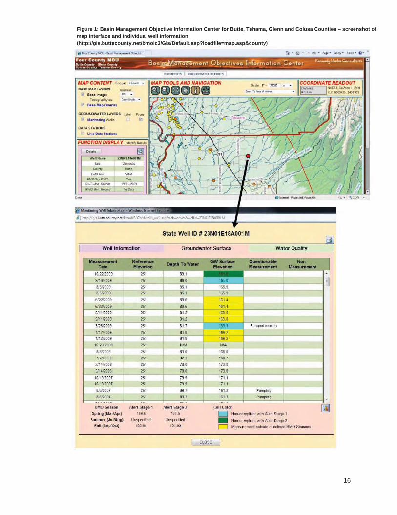
Butte County’s GWMP plans the development of quantitative BMOs, supported by a county ordinance (now Ch. 33A, Butte County Code) (Butte County, 2005, pp. 3-13, 13-20). That ordinance requires representatives from each BMO sub-area annually to report groundwater levels, groundwater quality, and subsidence monitoring results to the County water department to be assessed against the BMOs. Under its GWMP, Butte County also commits to pursuing funding to develop a web-based BMO Information Center for monitoring and reporting information. The Information Center’s interactive maps show monitoring wells for four adjacent counties. Each well can be selected to show current and historical groundwater elevation and quality data (sometimes stretching back decades), color-coded to show compliance or non-compliance with the county’s BMOs. See Figure 1: Basin Management Objective Information Center for Butte, Tehama, Glenn and Colusa Counties – screenshot of map interface and individual well information. The Information Center also houses annual BMO documents for each BMO sub-area, which explain how BMOs were developed for that year, and include monitoring data (http://www.buttecounty.net/Water%20and%20Resource%20Conservation/BMO.aspx).
16
Figure 1: Basin Management Objective Information Center for Butte, Tehama, Glenn and Colusa Counties – screenshot of map interface and individual well information (http://gis.buttecounty.net/bmoic3/GIs/Default.asp?loadfile=map.asp&county)

17
2. Cooperation and stakeholder participation
There are numerous barriers to local water agencies cooperating in groundwater management planning, including difficulties in building trust between local water management entities, and difficulties in matching benefits and funding burdens (GEI Consultants, 2009, p. 60). Further barriers prevent local water agencies from cooperating with other agencies, which undertake activities that can affect groundwater management, for example city land-use planning departments. Yet cooperation can save agencies time and money by reducing duplication in management efforts, taking advantage of economies of scale when contracting for similar goods and services, and avoiding inadvertently counterproductive management measures being taken by neighbors that are unaware of each other’s actions. The examples given below show the wide range of groundwater management issues on which local water agencies can cooperate.
Table 3: Subjects of collaboration between water agencies in GWMPs
Collaborating to investigate GW resources
In 2001, a group of 15 local water districts in the San Joaquin Valley, including the Poso Creek Regional Management group of 7 districts, jointly prepared a report analyzing local groundwater resources to identify favorable areas for groundwater recharge and recovery (Kern-Tulare Water Dist. & Rag Gulch Water Dist., 2006, p. 17).
Collaborating on a strategic data collection plan
After the Sacramento Groundwater Authority identified significant inconsistencies between the data collection methods of its 14 member agencies, it initiated a Standard Operating Procedure (SOP) for collecting water level data, provided member agencies with DPH guidelines for the collection of water quality data, and offered training in the use of these standards (Sacramento Groundwater Auth., 2008, pp. 44, App.D).
NB: See also Table 6: Gathering and standardizing information on groundwater status and use.
Coordinating to controlgroundwater-intensive development
An ordinance of the Sierra Valley Groundwater Management District (SVGMD) (Ordinance 83-01) puts in place arrangements commonly known as “assured water supply” rules. It requires any person who is seeking a land use approval from a local land use agency for a development that will use groundwater within the SVGMD’s boundaries, to file documents regarding the water source with the SVGMD. The SVGMD makes a finding as to whether there is sufficient groundwater available, and only then may the local agency approve the development.
NB: In relation to groundwater intensive development, see also Table 8: Methods of managing groundwater demand.
In addition to local agencies collaborating between themselves, a vast range of stakeholder groups has helped formulate GWMPs in California. Undeniably, broad stakeholder involvement takes time. Some GWMPs that cover large areas report up to 6 years of consensus-building and negotiation with tens of stakeholder groups (Sacramento County Water Agency, 2006, p. 1-4). However, broad stakeholder involvement brings multiple perspectives to help meet multiple objectives, and can help avoid conflicts that have derailed past groundwater management efforts, which were otherwise promising (Thomas, 2001, pp. 15-16, 19). Their involvement also helps to ensure that plans and programs are consistent across agencies, avoiding potential inter-governmental conflict, which can be particularly problematic in the groundwater sphere, when jurisdictional boundaries are blurred and may overlap (Thomas, 2001, pp.

18
24-25). Table 4 sets out examples of different structures for involving stakeholders in GWMPs.
Table 4: Structures for involving stakeholders in GWMPs
Structures for involving stakeholders
Stakeholders may be involved as part of a formal Stakeholder Group, or on formal committees such as a Technical Committee or Policy Committee formed to advise the GWMP agency, as is the case at the Borrego Water District (Borrego Water Dist., 2002, p. 17).
Similarly, the Glenn-Colusa Irrigation District’s GWMP provides for establishing a Basin Management Committee consisting of stakeholder representatives, which is charged with creating a Technical Advisory Committee to set limits on withdrawals and mitigation measures. The Basin Management Committee considers changes to the GWMP, the rules and regulations required to implement it, and budget issues (Glenn-Colusa Irrigation Dist., 1995, p. 35}.
Involving a broad range of stakeholders
GWMPs have involved a wide range of stakeholders, including:
Other local water supply-oriented entities, including water districts, irrigation districts, city utility departments, water agencies, water conservation districts, public works districts, county water districts, private water companies, surface water masters, etc (Castaic Lake Water Agency, 2003, p. 4; Yuba County Water Agency, 2005, p. 29).
General agricultural and business interests, e.g. farm bureaus, and chambers of commerce (Sacramento County Water Agency, 2006, p. 3-10).
Local residents who pump groundwater, including agricultural users and domestic users, and representatives from water users associations (Butte County, 2005, pp. 3-17, 13-18; HydroMetrics LLC, 2007, p. 8).
Members of the public generally (HydroMetrics LLC, 2007, p. 8).
Local, regional, and state-level environment- and community-oriented entities, e.g. the Sierra Club, The Nature Conservancy, other local environmental non-profits, the League of Women Voters, recreation and parks districts, and community associations (City of San Diego Water Dep't, 2007, App.G; Sacramento County Water Agency, 2006, p. 3-10).
State participants, including staffers of members of the State Senate and Assembly, representatives of the Department of Water Resources, the Department of Fish and Game, Regional Water Quality Control Boards, and nearby State Parks (HydroMetrics LLC, 2007, p. 8; N.E. San Joaquin County Groundwater Banking Auth., 2004, p. 4)
Federal participants, including the Natural Resource Conservation Service, U.S. Geologic Survey, U.S. Army Corps of Engineers (N.E. San Joaquin County Groundwater Banking Auth., 2004, p. 27).

19
Collaborating widely with agencies and stakeholders with different interest areas can attract numerous benefits, but may also invite disputes. GWMPs can address this proactively by incorporating explicit procedures for resolving disputes locally. Such procedures exist at various levels of formality (Table 5).
Table 5: Avoiding and resolving disputes when formulating and implementing GWMPs
Reaching consensus and avoiding disputes
The planning efforts of the Northeastern San Joaquin Groundwater Banking Authority and the Sacramento Groundwater Authority (formerly Sacramento North Area Groundwater Management Authority) both benefited from using the California Center for Collaborative Policy as a neutral third-party facilitator. These entities consider that using professional facilitators in the context of complex stakeholder negotiations is a key factor contributing to the success of their efforts (N.E. San Joaquin County Groundwater Banking Auth., 2004, p. 102; Thomas, 2001, p. 48).
Resolving disputes
The Olympic Valley and Soquel Area GWMPs explicitly nominate a process and a forum for resolving disputes. The body charged with implementing the GWMP hears disputes, receives submissions, holds public hearings, and makes decisions by majority vote, guided by “what action would serve the best interest of the public” (HydroMetrics LLC, 2007, p. 95; Soquel Creek Water Dist. & Cent. Water Dist., 2007, p. 136).
The Kaweah Delta Water Conservation District uses a formal dispute resolution policy to avoid litigation in relation to groundwater management by encouraging mediation (Kaweah Delta Water Conservation Dist., 2006, App.C).
The GWMP for the Turlock Groundwater Basin uses meetings of the Turlock Groundwater Basin Association, an association of local water agencies, to resolve issues associated with groundwater management. Meetings are open to the public (Turlock Groundwater Basin Assoc., 2008, pp. 1, 67).
3. Collecting information about groundwater context
Formulating a GWMP often occurs in complex and uncertain hydrological and ecological contexts. Collecting information about the status of groundwater bodies and groundwater use; standardizing data collection; sharing data; and considering the ecological impacts of management options all arise as concerns for GWMPs.
Historically, Californian local water agencies have strongly resisted metering groundwater use. This sentiment is slowly changing. Many special districts and some general districts now apply mandatory or voluntary groundwater metering. There is great variation in the motivations and practice of metering. Some agencies use metering as part of a program of imposing groundwater augmentation charges on users; others simply to improve their knowledge of the groundwater resource. Agencies require metering at different levels of use, and with different arrangements for reporting use.
There is much greater acceptance of the need to monitor groundwater levels, as distinct from use. However, many problems can strike a monitoring system, potentially compromising its comprehensiveness, accuracy, and the length of its record. Such issues appear common around the State. It is worth listing a small selection of these problems, to demonstrate the challenges that GWMPs should be designed to withstand. Economic factors can intervene: budget cuts can result in data gaps
20
and infrequent measurements; older wells with long measurement records can be abandoned when they require expensive maintenance; and production wells may be used without any dedicated monitoring wells, which can risk inaccurate data caused by a non-static water surface (Kings River Conservation Dist., 2005, p. 4-26; Turlock Groundwater Basin Assoc., 2008, p. 55; Yuba County Water Agency, 2005, p. 31). Data may be collected but not compiled into a useful format for many years (Yuba County Water Agency, 2005, p. 31). In some cases, the construction data associated with monitoring wells may be unknown, so that it is not clear which of several aquifers are being monitored (City of Tracy, 2007, p. 27). Sometimes monitoring systems are simply not evaluated for their sufficiency, particularly for assessing whether a GWMP is meeting its objectives, or to model the safe yield, or to model predicted responses to management actions selected for the GWMP.
There is also significant variation across the State in relation to monitoring groundwater quality, which is much less commonly monitored outside of municipal areas (see e.g., Carpinteria Valley Water Dist., 1996, p. 2; Kreinberg, 1994, p. 3-5). This makes it quite difficult to draw links between overdraft and changing water quality, although it is not uncommon for agencies to report such a connection (Indian Wells Valley Cooperative Groundwater Mgmt. Group, 2006, p. 2; Stanislaus & Tuolumne Rivers Groundwater Basin Assoc., 2005, p. 12; Turlock Groundwater Basin Assoc., 2008, p. 41). Using standard data collection and management methodologies or protocols to ensure that the data collected are accurate and consistent is as important as monitoring.
Final, as ecological concerns are becoming more prevalent in GWMPs, the plans should include strategies to collect information to determine how ecological conditions influenced by groundwater management are faring.
Table 6 sets out examples of how agencies gather and standardize data on groundwater and its context.
Table 6: Gathering and standardizing information on groundwater status and use
Monitoring the status of groundwater bodies
The Sacramento Groundwater Authority (SGA) and Western Placer CountyGWMPs aim to maintain a “consistent long-term network” of wells to monitor groundwater elevation, each measured at least semi-annually. The wells are selected “to provide uniform geographic coverage” throughout the respective areas, using a grid of polygons, each containing a monitoring well. Non-producing wells with long records of consistently collected data are favored for inclusion in the network (City of Roseville et al., 2007, p. 3-8; Sacramento County Water Agency, 2006, p. 3-11; Sacramento Groundwater Auth., 2008, pp. 38-39).
Butte County’s Groundwater Conservation Ordinance requires a countywide groundwater monitoring program that involves monitoring groundwater elevations either continuously using water level sensors, or otherwise at least four times per year (Butte County, 2005, p. 3-3), whereas semi-annual readings are much more common throughout the State.
Yuba County uses its monitoring network “both for the health of the long-term basin storage and for localized-short-term impacts of pumping”, with the latter particularly aimed at the effects of external groundwater transfers (Yuba County Water Agency, 2005, p. 30).
Meteringgroundwater use
The Pajaro Valley Water Management Agency generally requires every groundwater pump that produces 10 af/yr or more to be metered. It reads each flow meter twice per

21
year for the purposes of assessing groundwater augmentation charges (Pajaro Valley Water Mgmt. Agency, 1993; 1996).
The Fox Canyon Groundwater Management Agency requires metering of all wells except those which serve domestic purposes on parcels of land of one acre or less. The owner is responsible for associated expenses and must report groundwater use twice annually. The Agency undertakes random checks of meter reports to ensure they are accurate (Fox Canyon Groundwater Mgmt. Agency, et al., 2007, p. 49).
In certain zones of the Salinas Valley, the Monterey County Water Resources Agency requires wells used for agricultural, urban or industrial purposes to be metered if they have a diameter of three inches or more, with operators required to report their use annually (Monterey County Water Resources Agency, 2006, p. 4-2).
Standardizing data collection andmanagement, and sharing data
The primary purpose of the GWMP for the Gillibrand Groundwater Basin is to “present a standard methodology for the collection of data” on groundwater levels, use and quality, which applies to the basin’s two largest water users, being a county waterworks district and a private mining company. The methodology covers measurement instruments, the frequency of measurement, quality assurance procedures, data storage, and procedures for reporting data (Geoscience Support Services Inc., 2007). The GWMP demonstrates that private and public entities can work together to standardize data collection and management.
The San Benito GWMP includes in its list of actions for meeting its objectives, a plan to develop jointly with “all local agencies involved in water-related data collection and management … a strategic program for data collection and management”, aimed at supporting groundwater management decision-making. It should “specify the types of data to be collected and the frequency of measurement; evaluate the accuracy of data collection procedures; outline the structure, format, and units to be used in computerized databases; and indicate procedures to ensure data consistency and transfer among agencies” (Jones & Stokes Assoc., 1998, p. 65).
The Sacramento Groundwater Authority is also developing a standard Water Accounting Framework for its member agencies. See Table 10: Methods of protecting and enhancing recharge and examples of water banking.
Collecting data relevant to the health of groundwater dependent ecosystems
The Lassen County GWMP “supports efforts to map and compile information on riparian habitats and phreatophyte vegetation” (Brown & Caldwell, 2007b, p. 3-7).
Whereas much groundwater use for consumptive purposes in California depends on deep aquifers, ecosystems associated with wetlands may be connected to shallow aquifers. In such situations, monitoring the state of shallow aquifers is important to assessing ecological impacts. The Squaw Valley Public Service District’s GWMP includes monitoring shallow groundwater levels in the Olympic Valley meadow, which are connected to wetlands that have high ecological and aesthetic value (HydroMetrics LLC, 2007, p. 64).

22
4. A portfolio approach to groundwater management planning
A portfolio approach to groundwater management planning responds to information collected (including information from stakeholders) about the values of a resource, with goals that champion those values and multiple strategies for pursuing those goals. Goals include securing water supplies for consumptive purposes, maintaining or restoring ecosystems, protecting connected surface waters, and ensuring that groundwater use minimizes third-party impacts on society. This section sets out examples of agencies that adopt and pursue each of these goals, and the strategies they use to do so.
4.1 Securing groundwater supply for the long term
Securing groundwater supplies for consumptive purposes is the overriding focus of many GWMPs. The innovative strategies presented here emphasize an extensive range of options, beyond simply building more—or bigger—infrastructure solutions. They include limiting waste or drawdown in different ways, managing water demand using fees and education, using different water sources conjunctively, protecting and enhancing recharge, and water banking.
Table 7 outlines various mandatory measures to limit pumping, either directly, or by controlling developments that use groundwater intensively.
Table 7: Methods of controlling groundwater extraction: limiting waste, groundwater drawdown, or pumping
Defining sustainable yield and an acceptable operating range
The Central Sacramento County GWMP uses a “long-term average annual pumping limit” of 273,000 af/yr which stakeholders accepted as a negotiated limit “under which groundwater can be pumped and not exceed average natural recharge over a long-term period of time”. Negotiators developed this limit by using groundwater models to quantify basin conditions in terms of four key areas of impact: water quality degradation; dewatering of wells; higher pumping costs; and ground subsidence,
in 10-year increments from 1990 to 2030, comparing the impacts of different pumping levels to baseline pumping levels. The chosen sustainable yield level was found to maximize the yield of the aquifer while minimizing the four key impacts. In addition, the GWMP sets out an “operating range” of groundwater levels that will minimize these impacts for different areas of the basin (Sacramento County Water Agency, 2006, pp. 2-29, 3-23, App.A). However, the projections included in the GWMP do not include uncertainties, and it appears that historical hydrological data was used rather than data which attempts to factor in potential climate change impacts.
Taking action in response to non-compliance with BMOs
Glenn County’s GWMP, which itself is an ordinance, sets out a process for taking action in the event that its basin management objective for groundwater levels is breached. Its Technical Advisory Committee reports the details of the non-compliance to its Water Advisory Committee and the public, and recommends a course of action within five days. Negotiation with parties in the area is the preferred way to resolve the non-compliance, but should that fail, “the Water Advisory Committee may recommend a plan to the Board to modify, reduce or terminate groundwater extraction in the

23
affected area for the remainder of that irrigation season”, first in relation to wells involved in exports, then in relation to all other wells (Glenn County, 2000, [20.03.120], [120.103.130]).
Controllingpumping by using area limits
The Western Canal Water District GWMP envisions its Board of Directors annually re-evaluating its basin management objectives, including by considering whether to establish “quantitative limitations on groundwater extractions from particular areas . . . to limit adverse impacts of groundwater extractions on wells within and without the District” (Western Canal Water Dist., 2005, [3.2.3]). The District has adopted rules and regulations to implement and enforce its GWMP (Western Canal Water Dist., 2006); this would presumably be the vehicle for implementing pumping limits.
Controllingpumping by using individual extraction permits
The Groundwater Extraction Permit Ordinance of the Mendocino City Community Services District (MCCSD) requires any person who seeks “to extract groundwater for a new development, change in use, expansion of existing use, or to construct or modify a well” to obtain a permit. A permit allows the holder to extract only the quantity of water which is deemed necessary under “water use standards” that form part of the Ordinance. New wells are metered, and the District retains the right to enter the permit holder’s premises to collect meter information. Violating the ordinance attracts penalties, including rescission of an extraction permit (Mendocino City Community Services Dist., 1990 (as amended, 2007), p. 21, 2007).
Controllingpumping by prohibiting new wells
MCCSD’s GWMP envisions prohibiting any new wells in times of serious water shortage, in addition to other mandatory measures (Mendocino City Community Services Dist., 1990 (as amended, 2007), p. 108).
Under Sutter Extension Water District’s GWMP, after 1995, landowners who wish to construct new wells “may be required” to request the approval of the District’s Board of Directors, which may approve the request with conditions (Sutter Extension Water Dist., 1995, p. 8).
Controlling water waste
The Pajaro Valley Water Management Agency has adopted an ordinance prohibiting water waste (Ordinance 92-1). The Ordinance defines water waste and prohibits listed wasteful practices within the boundaries of the Agency. It prohibits wasteful practices in agriculture as well as urban settings, although the former are specified in vague terms (e.g. “unreasonable evaporation loss” and “unreasonable deep percolation loss”). The Ordinance sets out a system of warnings followed by enforcement proceedings heard before a panel, and a penalty structure for first and repeated violations.
Adjudicatinggroundwater basins
Only one GWMP reviewed for this report—that of the Borrego Water District—lists adjudicating the groundwater basin as a management tool, albeit the lowest priority option (Borrego Water Dist., 2002, p. 74).
Limiting the expansion of water-intensive uses
Spurred by the recommendations of a local planning advisory group, Borrego Water District’s GWMP includes the following potential strategies to limit the development of water-intensive land uses (Borrego Water Dist., 2002, pp. 57-59):
prohibiting the as-of-right conversion of unused land to agriculture (agriculture would only be allowed to be developed under a permit to be issued after a public

24
hearing and environmental review);
designating all unused land as “Desert Estate”, which would allow 10 or 20 acre lot subdivisions, but would limit the use of non-native plants to a small portion of the lot; and
requiring future developments that seek a domestic water service from the Borrego Water District to sign over their rights to extract groundwater to the District (a strategy for which there is a precedent in the Borrego Valley).
Rotating/fallowingcropland
The Eastern San Joaquin Basin GWMP very cautiously mentions “voluntary crop rotation”, which would compensate farmers for removing cropland from production, as a groundwater management tool (N.E. San Joaquin County Groundwater Banking Auth., 2004, p. 87).
The Borrego Water District more proactively includes in its GWMP a goal of obtaining funding to acquire agricultural land from willing sellers, and contemplates “paying farmers to not farm”. The GWMP suggests that such a program could be funded by a water use fee, and sets out sample costs (Borrego Water Dist., 2002, pp. 60-64, 71-73).
GWMPs commonly include general statements about “raising public awareness” of overdraft and groundwater management or implementing “education measures” about conservation. However, relatively few refer to concrete actions to manage water demand; even fewer are specific to groundwater, or relate to non-municipal contexts. Moreover, no surveyed plan quantifies the effectiveness of such voluntary demand management programs. It is therefore difficult to describe best practice in this area.
Some examples of education measures contemplated by GWMPs include: water utilities participating in local fairs, inserts in water bills detailing water conservation tips, public signs, demonstration gardens for low water use, fact-sheets, water use audits and surveys, school education, rebates on water efficient appliances, water education classes and presentations (Borrego Water Dist., 2002, p. 73; City of San Diego Water Dep't, 2007, App.G-6; HydroMetrics LLC, 2007, p. 86; Mendocino City Community Services Dist., 1990 (as amended, 2007), pp. 111-112; Neuman, 1998; Orange County Water Dist., 2009, p. 1-9; Soquel Creek Water Dist. & Cent. Water Dist., 2007, pp. 59, 113-117, 125-127).
In the agricultural conservation sphere, programs include supporting organizations that carry out field irrigation evaluations and farm water conservation assistance and farm water tours (Kaweah Delta Water Conservation Dist., 2006, p. 16; North Kern Water Storage Dist. & Rosedale Range Improvement Dist., 1993, p. 10; Reclamation Dist. 2068, 2005, p. 3-9). More detailed examples of agricultural water demand reduction programs have been compiled outside of GWMPs (Agricultural Water Mgmt. Council, 2008).
Reducing water demand may, unfortunately, jeopardize the ability of agencies to carry out resource-intensive groundwater management programs by reducing revenue (Orange County Water Dist., 2009, p. 6-14). Ensuring that groundwater management programs are financially sustainable is vital (see section 4.4 of this report).
Fees can be used both to reduce demand and also to sustain other groundwater management actions. Table 8 sets out methods of reducing demand using fees.

25
Table 8: Methods of managing groundwater demand
Using fees to manage demands on aquifers
Under Orange County Water District’s much-celebrated pump-and-pay system, retail groundwater pumpers pay fees (a “replenishment assessment”) to OCWD based on their metered usage. Additional fees (a “basin equity assessment”) apply above a pre-determined allowable pumping amount, expressed as a ratio of the customer’s groundwater pumping to its total water usage (the “basin production percentage”, BPP). These fees are used to purchase imported water to replenish groundwater, administer water monitoring, and maintain the replenishment systems. The fees are structured so as to create a disincentive to use groundwater above the BPP (Orange County Water Dist., 2009, pp. 1-5, 5-28, 26-13).
Similarly, the Fox Canyon Groundwater Management Agency imposes penalties on pumpers who extract more water than is allowed under the Agency’s detailed allocation system. Its GWMP proposes using these penalties to purchase water to replace the extracted water (Fox Canyon Groundwater Mgmt. Agency, et al., 2007, p. 80).
The Soquel Creek Water District uses tiered pricing (also described as increasing block water pricing) in the context of groundwater distribution systems for residential, commercial and agricultural purposes (Soquel Creek Water Dist. & Cent. Water Dist., 2007, p. 59).
Beyond manipulating demand by mandatory, voluntary or fee-based means, agencies may effectively increase their water supplies by using water from different sources in a conjunctive way (Table 9). This can involve introducing altogether new sources of water with different characteristic reliability profiles. For example, desalinated water and recycled water from municipal sources provide a supply that is largely unaffected by climatic conditions. Managing pumping distribution can “smooth” pumping pressure and ensure more uniform drawdown, avoiding deep cones of depression. This technique is also used to help avoid harming groundwater quality, and the flows and quality of connected surface waters.
Table 9: Methods of using different water sources conjunctively
Encourage greater surface water use
Agencies in the Modesto Sub-Basin and the Chowchilla Groundwater Basinregard annexation as a potential groundwater management tool, through in-lieu recharge—annexation enables areas reliant solely on groundwater to access surface water, thereby reducing pumping pressure (Chowchilla Water Dist.-Red Top Resource Conservation Dist. Joint Powers Auth., 1997, p. 13; Stanislaus & Tuolumne Rivers Groundwater Basin Assoc., 2005, pp. 28-29, 96).
The Soquel Creek Water District uses incentives to encourage private well owners to cease using well water and connect to water distribution systems (Soquel Creek Water Dist. & Cent. Water Dist., 2007, p. 107).
Managing surface water-groundwater substitutions
The Western Canal Water District envisions transferring surface water out of the district, to be replaced by increased groundwater pumping. In such cases, monitoring and metering rules apply to ensure that: (1) the action does not create or exacerbate overdraft; (2) the additional volume pumped does not exceed the volume of surface water transferred; and (3) to mitigate any adverse effects of lower groundwater levels

26
on farmers, e.g. by compensating them for additional energy costs (Western Canal Water Dist., 2005, p. 19, 2006, section VI).
Using desalinatedseawater or brackish groundwater
Several agencies commit to investigating and pursuing desalinating brackish groundwater as an additional source of supply (City of San Diego Water Dep't, 2007, pp. 1-5, 3-49, 43-50; Monterey County Water Resources Agency, 2006, p. 2-1). Alameda County Water District’s Newark Desalination Facility (part of its Aquifer Reclamation Program) has desalinated brackish groundwater caused by past seawater intrusion, since 2003. The Program aims to meet multiple objectives: “1) increase useable basin storage, 2) improve overall water quality, 3) prevent movement of brackish water toward ACWD production wells, and 4) provide (future) supply augmentation” (Alameda County Water Dist., 2010, p. 6; 2001, pp. 4, A1-7, A1-8). Agencies in the Fox Canyon Groundwater Management Agency’s area have also seriously considered desalinating brackish groundwater to move pumping away from areas of lowering groundwater levels, increase supply, deal with water quality degradation, and potentially also restore coastal wetlands (Fox Canyon Groundwater Mgmt. Agency, et al., 2007, pp. 54-58).
The Soquel Creek Water District intends to partner with the City of Santa Cruz to construct and operate a seawater desalination plant as a way to reduce pumping demands during dry years and reduce the potential for seawater intrusion (City of Santa Cruz & Soquel Creek Water Dist., 2010; Soquel Creek Water Dist. & Cent. Water Dist., 2007, p. 62).
Managing pumping distribution
Orange County Water District’s Temporary Coastal Pumping Transfer Program shifted pumping pressure from the coast to inland areas to minimize seawater intrusion (Orange County Water Dist., 2009, pp. 6-16). Similarly, modeling a shift in pumping pressure in the Pajaro Valley was found to “nearly double the basin sustainable yield” by preventing seawater intrusion (Pajaro Valley Water Mgmt. Agency, 2002, p. 3-4).
In the inland area of Indian Wells Valley, managing the spatial distribution of new wells to minimize adverse effects on groundwater quality is a GWMP objective (Indian Wells Valley Cooperative Groundwater Mgmt. Group, 2006, p. 3). Similarly, the GWMP for the Modesto Sub-Basin contemplates optimizing well operations to achieve multiple different objectives, including “minimizing pumping costs, maintaining groundwater levels within a specified range . . . avoiding the migration of contaminant plumes”, and improving downstream water quality by reducing high groundwater levels in areas of poor groundwater quality (Stanislaus & Tuolumne Rivers Groundwater Basin Assoc., 2005, p. 123).
County well permitting requirements that apply within the Fox Canyon Groundwater Management Agency’s area shift pumping from a lower aquifer system to an upper aquifer system, to reduce the potential for overdraft and seawater intrusion in the lower system and ensure conjunctive use of both groundwater sources. Another tool considered in the area is shifting pumping to areas which are comparatively easy to recharge (Fox Canyon Groundwater Mgmt. Agency, et al., 2007, pp. 47, 76).

27
In addition to limiting extraction from a basin, agencies’ GWMPs also plan to maximize “deposits” to a basin, by either protecting or enhancing natural recharge, or “banking” water for themselves or third parties, using recharge basins or injection wells (Table 10).
California’s groundwater laws—or rather, legal uncertainties—challenge the development of groundwater banking. Legal uncertainties surround who is liable for displacing natural recharge; how to control the actions of third parties who are not party to management agreements, where their actions affect the quality or quantity of stored water; and liability for changes in water quality, to name a few (Foley-Gannon, 2008). One GWMP refers to “the monumental task of overcoming the institutional, political, financial and physical challenges of groundwater banking” (N.E. San Joaquin County Groundwater Banking Auth., 2004, p. 20).
Table 10: Methods of protecting and enhancing recharge and examples of water banking
Protecting existing recharge areas
As an initial step, the Sonoma Valley GWMP calls for “studies to identify groundwater recharge areas, to develop approaches to enhance groundwater recharge, and to identify ways to protect recharge areas from being covered by low permeability surfaces” (Sonoma County Water Agency, 2007, p. 3-3).
The GWMP for the Modesto Sub-Basin takes a slightly more developed approach. It directs its implementing agencies to “[i]dentify areas having high potential for contributing to aquifer recharge and encourage agencies to communicate with land use planning entities to enact measures that will protect these lands from development that would reduce their value as recharge sites”. It also includes, as a potential groundwater management tool, “pricing and incentive programs to encourage the continued use of surface water for flood irrigation” in areas with significant recharge potential (Stanislaus & Tuolumne Rivers Groundwater Basin Assoc., 2005, pp. 108, 120).
The GWMP of the Fox Canyon Groundwater Management Agency considers a strategy of requiring “Low Impact Development” to maximize the infiltration of stormwater in new developments that overlie recharge areas, but does not outline how this might be achieved (Fox Canyon Groundwater Mgmt. Agency, et al., 2007, p. 69).
The GWMP for the Soquel-Aptos area outlines an objective of participating in land use planning processes and supporting Santa Cruz County to protect and enhance groundwater recharge zones. Specific actions include supporting the County to update its groundwater recharge maps, supporting USGS in its work characterizing recharge areas, and pursuing a formal system for allowing water agencies to review development proposals that could affect primary recharge zones (Soquel Creek Water Dist. & Cent. Water Dist., 2007, pp. 75, 99, 100).
Enhancing recharge
The GWMP for the Soquel-Aptos area documents cooperation between Santa Cruz County, the GWMP agencies, and other neighboring water and resource agencies to introduce a recharge enhancement element to projects designed to control erosion and reduce stormwater runoff. The GWMP agencies pledge to “support County efforts to develop a program that will include standards regulating impervious surfaces . . . and provide for water impoundments, protecting and planting

28
vegetation, and installing cisterns, dry wells, bioswales and other measures to increase runoff retention and groundwater recharge”. They also commit to incorporating such design features in their own construction projects (Soquel Creek Water Dist. & Cent. Water Dist., 2007, pp. 102-103).
Replenish GW for later use
The Santa Clara Valley Water District manages extensive recharge facilities, including 90 miles of stream channel and spreader dams, 71 off-stream recharge ponds, and an injection well. Its recharge water sources are imported water and local surface water. The aim of the program is to “sustain groundwater supplies through the effective operation and maintenance of District recharge facilities” (Santa Clara Valley Water Dist., 2001, pp. 16-18). The District releases an annual report on its groundwater augmentation activities, the most recent of which states that 65% of groundwater pumped in the County originates from artificially replenished water (Santa Clara Valley Water Dist., 2010, p. i).
The Kings River Conservation District GWMP includes the North Fork Group Program as an economical recharge strategy. It involves flooding seasonally fallowed agricultural areas and keeping canals full to increase percolation. It proposes to continue this Program and develop better ways of monitoring and measuring recharge (Kings River Conservation Dist., 2005, pp. 4-10, 14-11, 14-14, 16-14, 16-15).
Water banking for third parties
The Arvin Edison Water Storage District is party to a 25-year agreement with the Metropolitan Water District of Southern California (MWD), which began in 1997, to bank 250,000 ac-ft of MWD’s water below Arvin-Edison. Water is delivered to Arvin-Edison using the Cross Valley Canal, and is returned (since 2003) during drought years, using the California Aqueduct. The program funded $25 million of capital works and reimburses Arvin-Edison for pass-through water banking costs (Arvin-Edison Water Storage Dist., 2003, p. 6). Arvin-Edison’s Rules and Regulations specify that where it spreads water, or delivers surface water to landowners in lieu of them pumping, it has the exclusive right to use the groundwater storage to recover the water to supply district landowners or third parties (Arvin-Edison Water Storage Dist., 2006, cl.9).
The Sacramento Groundwater Authority, which manages the North Area Groundwater Basin in cooperation with its 14 member agencies, is developing a centralized Water Accounting Framework (WAF) to support groundwater banking programs by “setting forth rules for operating a model groundwater bank, and monitoring the basin to ensure its sustainability”. The SGA will maintain modeling and management tools needed to assess conjunctive use operations and maintain accounting systems for “deposits” and “withdrawals” (Sacramento Groundwater Auth., 2008, pp. 54-55).
The GWMP of the Northeastern San Joaquin County Groundwater Banking Authority, which has eleven member agencies, adopts third party water banking and conjunctive use partnerships as a key element of the plan. This involves many individual sites, some then operating and some to be developed, numerous different surface supply sources, and all forms of recharge methods (direct injection, percolation, and in-lieu) (N.E. San Joaquin County Groundwater Banking Auth., 2004). The Authority recently released its Eastern San Joaquin Integrated

29
Conjunctive Use Program Draft Environmental Impact Report (http://www.gbawater.org/news_events/public_notices.html).
4.2 Protecting connected surface waters
Californian law generally treats groundwater and surface water separately, though there are some exceptions to this (Hanak, et al., 2010, pp. 54-57). Some local agencies explicitly seek to ensure that groundwater pumping does not cause adverse impacts on surface waters, and implement corresponding measures (Table 11). These measures include studying the interaction between water bodies and reducing the effects of groundwater extraction on surface water.
Table 11: Methods of protecting connected surface waters
Explicitly recognize a goal relating to surface water impacts of groundwater pumping, or vice versa
The Sonoma Valley GWMP includes as a Basin Management Objective (BMO) to “protect against adverse interactions between groundwater and surface water” in relation to Sonoma Creek, which provides habitat for fish and other wildlife and is a source of supply for agriculture, businesses and residences (Sonoma County Water Agency, 2007, pp. 3-4).
The Olympic Valley GWMP includes BMOs to “[p]romote viable and healthy riparian and aquatic habitats by avoiding or minimizing future impacts from pumping on stream flows” and to “[s]upport ongoing stream restoration efforts as they relate to groundwater management” (HydroMetrics LLC, 2007, p. 70).
The Western Canal Water District GWMP aims both to “[m]inimize changes to surface water flows and quality that directly affect groundwater levels or quality” and also to “[m]imimize the effect of groundwater pumping on surface water flows and quality” (Western Canal Water Dist., 2005, [1.2]), although the GWMP does not appear to include any measures directly specifically to these aims.
Study surface water- groundwater interaction
A component of the Soquel-Aptos area GWMP is to use stream gauges and shallow groundwater monitoring wells adjacent to and in Soquel Creek to investigate surface water-groundwater interactions (Soquel Creek Water Dist. & Cent. Water Dist., 2007, pp. 77, 83).
The Olympic Valley GWMP includes as management measures participating in stream/aquifer interaction studies, and annually analyzing baseflow trends, shallow groundwater level trends, and “changes in apparent stream-aquifer interaction” (HydroMetrics LLC, 2007, p. 71).
The Central Sacramento County GWMP provides for updating and using an integrated groundwater and surface water model (Sacramento County Water Agency, 2006, p. 3-22).
Include measures to reduce pumping impacts on surface waters
The Soquel-Aptos area GWMP documents a policy of the Soquel Creek Water Management District to use incentives (such as reduced connection fees) to encourage groundwater users with wells located near Soquel Creek to connect to the District’s distribution system. The GWMP includes modifying pumping distribution based on annual analyses of data collected under the District’s groundwater and

30
surface water data program, if, for example, it discloses evidence of baseflow depletion (Soquel Creek Water Dist. & Cent. Water Dist., 2007, pp. 107-108).
The Olympic Valley GWMP envisions carrying out its BMOs related to surface water interaction by redistributing pumping to reduce surface water impacts and reducing pumping through conservation (HydroMetrics LLC, 2007, pp. 70-71). It does not explicitly address the potential reduction in runoff from conservation, and any consequences for streamflow.
4.3 Restoring ecosystems and minimizing ecological impacts
Many of the measures described above in relation to securing a long-term groundwater supply and protecting surface waters from the adverse impacts of groundwater pumping also help to protect ecosystems from adverse impacts. For example, conservation measures can reduce total groundwater extraction, limiting groundwater drawdown and therefore helping to maintain connections with wetlands. Conversely, some ecological projects can benefit groundwater storage, for example, stream restoration can result in greater recharge, increasing shallow groundwater levels and thereby increasing shallow groundwater storage (HydroMetrics LLC, 2007, p. 64).
Table 12 presents examples of agencies consciously aiming for and acting on ecological goals in groundwater management planning.
Table 12: Methods of restoring ecosystems and minimizing ecological impacts
Explicitly recognize ecological goals
The Squaw Valley Public Service District’s GWMP includes as one of three overarching goals, to “protect, promote, and improve the environmental quality of Olympic Valley” (HydroMetrics LLC, 2007, p. 62). The Basin Management Objectives which underlie this goal include to:
“promote viable and healthy riparian and aquatic habitats by avoiding or minimizing future impacts from pumping on stream flows”,
“minimize future impacts from pumping on identified wetlands”, and
“support ongoing stream restoration efforts as they relate to groundwater management” (HydroMetrics LLC, 2007, pp. 63-64).
The Lassen County GWMP includes as an objective to “maintain springs, seeps and riparian habitat” (Brown & Caldwell, 2007b, pp. 1-2).
Recognize and quantifyenvironmental water demands
The Alpine County GWMP includes, by way of characterizing the aquifer and its context, environmental water demands, which “would include State and Federal wildlife refuges, and publicly or privately managed wetland habitat”. However, for reasons that are unclear, these demands are allocated zero acre-feet of water (Brown & Caldwell, 2007a, p. 37).
Similarly, the Central Sacramento County Water Authority GWMP recognizes “environmental water” as a source of demand, but simply notes that the demand has not been defined for various streams, and does not allocate responsibility for defining

31
these demands or attempt to estimate them (Sacramento County Water Agency, 2006, p. 2-47).
The Soquel-Aptos area GWMP seeks to “avoid alteration of stream flows that would adversely impact the survival of populations of aquatic and riparian organisms”. This is defined as maintaining baseflow depletion (caused by pumping aquifers adjacent to identified streams) below current detection levels in order to avoid “significant adverse biological effect” (Soquel Creek Water Dist. & Cent. Water Dist., 2007, p. 76).
Mitigate effects of overdrafted areas on stream flows
The East Sacramento County Replacement Water Supply Project, described in the Central Sacramento County Water Authority GWMP, provides for releasing environmental water to the ecologically significant Cosumnes River. Although the Cosumnes River historically flowed year-round, it now has completely dry stretches during summer (primarily due to groundwater pumping), when flows are lost to the aquifer. The Project pre-wets the riverbed so that a smaller volume of late fall and summer flows is lost from the river to the underlying overdrafted aquifer, with adverse effects on riparian habitat (Sacramento County Water Agency, 2006, pp. 2-7, 2-44, 3-18).
Locate & design recharge basins to enhance wildlife habitat
The Kings River Conservation District’s GWMP describes the 6000-acre Gragnani constructed wetland project, which was designed for habitat purposes. It has the secondary benefit of providing “in lieu recharge” by offering an alternative water supply to former groundwater users. The project was developed by the USDA Natural Resources Conservation Service purchasing conservation easements and recharging the wetlands using flood waters (Kings River Conservation Dist., 2005, pp. 4-2, 4-3).
The Farmington groundwater recharge project described in the Eastern San Joaquin GWMP uses land leased from farmers at market rates, primarily to reduce saline intrusion and overdraft, and secondarily to provide seasonal habitat for migratory waterfowl. The American Society of Civil Engineers awarded it the Water/Environment Project of the Year in 2003 (N.E. San Joaquin County Groundwater Banking Auth., 2004, pp. 30, 133-137; http://www.farmingtonprogram.org/).
Remove non-native invasive species
The San Diego City water department supports programs that map and remove giant reed, tamarisk, and perennial pepperweed, which are local non-native invasive species that impact groundwater quantity, although the GWMP does not quantify what impact this has on water supplies (City of San Diego Water Dep't, 2007, p. 2-44).
4.4 Considering economic and financial sustainability
Economic factors are often the elephant in the groundwater management room. While many GWMPs cite the economically “unfeasible” nature of reducing groundwater usage through methods such as voluntary crop fallowing, no GWMP reviewed for this report quantified such impacts, nor estimated the impacts of not controlling groundwater use. Encouragingly, some GWMPs at least recognize the gravity of the latter.

32
Some agencies also seek to put in place measures to compensate well owners for the adverse economic impacts of decreasing groundwater levels.
Ironically, water shortages, including shortages caused by overdraft, threaten not just water users, but also the financial ability of agencies to undertake groundwater management actions to alleviate shortages. The costs of managing groundwater are likely to increase markedly during droughts, with additional enforcement and public outreach, for example, while the revenue of an agency may decrease as water usage drops. Finding a mechanism for sustainably funding groundwater management, under which customer water usage is decoupled from agency revenue is therefore vitally important (Mendocino City Community Services Dist., 1990 (as amended, 2007), p. 112).
Table 13 presents examples of agencies considering economic and financial sustainability in groundwater management planning.
Table 13: Methods of considering economic and financial sustainability
Considering the economic costs of not controlling groundwater use
The GWMP for the Merced Groundwater Basin acknowledges that long-term groundwater level declines due to pumping can increase the cost of pumping water and “restrict economic development” (AMEC Geomatrix Inc, 2008, p. 6). The Eastern San Joaquin Groundwater Basin GWMP recognizes that failing to address water management needs will lead to adverse impacts that will result in “business flight, job loss, loss of revenue for public services and general economic decline” (N.E. San Joaquin County Groundwater Banking Auth., 2004, p. 20). However, neither plan attempts to quantify these effects, or assess the long-term economic costs of overdraft against the short-term economic benefits of pumping.
Mitigating the economic costs of overdraft
The Central Sacramento County GWMP includes establishing a Central Basin Well Protection Program, including a “well protection trust fund”. The fund will compensate owners of wells that have failed due to declining groundwater levels for the cost of deepening or replacing wells. The fund will be financed by fees collected as part of building permits for new construction, or well drilling permits. Only well owners who register their wells are eligible for compensation, so that the system also improves information about groundwater use. The fund came about because the sustainable yield negotiated for the GWMP was expected to result in further declines in groundwater levels, before they stabilized, and “current groundwater users should not have to subsidize future growth in the basin by paying the cost of deepening or replacing existing wells” (Sacramento County Water Agency, 2006, pp. 4-7 to 4-9). The recent economic downturn has resulted in the implementation of the fund being delayed (Sacramento Cent. Groundwater Auth., 2009, p. 22).
Ensuring sustainable funding for groundwater management
The Mendocino City Community Services District ensures that its groundwater management activities are sustainable even during droughts, when revenue may drop, by using a surcharge on wastewater and sewer usage fees to fund groundwater management (Mendocino City Community Services Dist., 1990 (as amended, 2007), p. 112).
33
PART SIX: CONCLUSION AND NEXT STEPS
The stage for California’s groundwater management planning is a complicated and crowded one, filled with numerous actors of different types, who face difficult and sometimes critical groundwater depletion problems. Various institutional barriers often prevent these actors from talking to each other and sharing their stories of groundwater management successes and challenges. Since California’s groundwater management planning laws do not involve State oversight, information about GWMPs is difficult to collect, and the state of Californian groundwater management has remained in shadow.
First and foremost, this report has shone a spotlight on some of these actors, and demonstrated that elements of their groundwater management planning efforts present promising and innovative approaches to local groundwater management. While their innovations are not necessarily common, they chart a path to better groundwater management that is practical and doable in a wide variety of different agency circumstances. It is hoped that local agencies around California will consider the approaches described here in formulating their own groundwater management actions, recognizing that management innovation is not necessarily precluded by scarce resources, or any particular statutory form.
Having used GWMPs to identify agencies whose water planning efforts stand out as exceptional in California, the next step is to determine whether these efforts are resulting in successful implementation,on the ground. Further research should ask of agencies questions like:
Do you actively use your groundwater management plan—is it a “living” document, or a reference for occasional use?
Which elements of your plan have been implemented? Did the process of formulating and implementing the plan lead to changes in how you
manage groundwater? What are your success stories in formulating and implementing the plan? What constraints have you encountered in formulating and implementing the plan?
At a higher level, this report has contrasted California’s groundwater management planning laws with those for urban water management plans, and suggested that water planning law has moved far beyond the current requirements and policy in relation to GWMPs. The many examples of innovative groundwater management planning by California agencies also confirm that the aspirations of GWMP law and policy are out of date.
Questions of State regulation of groundwater aside, there is a need to reform California’s GWMP laws and policies to include demand management, and require greater analysis of the planning context, greater accountability through stakeholder participation, and the pursuit of multiple goals. Strengthening California’s legislation for groundwater management planning provides a path towards better groundwater management, retaining the State’s historical focus on local agencies driving local change. Reform that strengthen and update this legislation would build on a familiar base, and, judging from the significant number of plans in California, one with which many local agencies are comfortable. Law and policy should follow California’s innovative local groundwater management agencies, and lead its groundwater agencies as a whole, down the path that this report suggests is both desirable, and also possible.

34
REFERENCES
Agricultural Water Mgmt. Council. (2008). Efficient Water Management: Irrigation District Achievements.Available at http://www.agwatercouncil.org/Publications/Efficient-Water-Management-irrigation-district-achievements/menu-id-86.html.
Alameda County Water Dist. (2001). Groundwater Management Policy.
Alameda County Water Dist. (2010). Survey Report on Groundwater Conditions.
Alley, W. M., Reilly, T. E., & Franke, O. L. (1999). Sustainability of Ground-Water Resources: U.S. Geological Survey Circular 1186. Available at http://pubs.usgs.gov/circ/circ1186/.
AMEC Geomatrix Inc. (2008). Merced Groundwater Basin Groundwater Management Plan Update: Merced County, CA.
Angiola Water Dist., Atwell Island Water Dist., City of Corcoran, Corcoran Irrigation Dist., Melga Water Dist., & Tulare Lake Basin Water Storage Dist. (1999). Tulare Lake Bed Coordinated Groundwater Management Plan.
Arvin-Edison Water Storage Dist. (2003). Groundwater Management Plan.
Arvin-Edison Water Storage Dist. (2006). Rules and Regulations for Distribution of Water.
Bergkamp, G., Gregory J. Hobbs, J., & Iza, A. (2009). Linking Policies to Realities. In A. Iza & R. Stein (Eds.), Rule: Reforming Water Governance, 31. Gland, Switzerland: IUCN.
Borrego Water Dist. (2002). Borrego Water District Groundwater Management Plan.
Brooks, D. B., Brandes, O. M., & Gurman, S. (Eds.). (2009). Making the Most of the Water We Have: The Soft Path Approach to Water Management. London: Earthscan.
Brown & Caldwell. (2007a). Alpine County Groundwater Management Plan.
Brown & Caldwell. (2007b). Lassen County Groundwater Management Plan.
Butte County. (2005). Butte County Groundwater Management Plan.
Cal. Dep't of Water Resources. (2003). California's Groundwater: Bulletin 118 (Update 2003). Available at http://www.water.ca.gov/groundwater/bulletin118/bulletin118update2003.cfm.
Cal. Dep't of Water Resources. (2008). Managing an Uncertain Future: Climate Change Adaptation Strategies for California’s Water. Available at http://www.water.ca.gov/climatechange/docs/ClimateChangeWhitePaper.pdf.
Cal. Dep't of Water Resources. (2009). Court Adjudications. Available at http://www.water.ca.gov/groundwater/gwmanagement/court_adjudications.cfm.
Cal. State Controller. (2010). Special Districts Annual Report 2007-2008 (58th ed.). Available at http://www.sco.ca.gov/ard_locarep_districts.html.
Caponera, D. A. (2007). Principles of Water Law and Administration (2nd ed, rev. and updated by Marcella Nanni ed.). London: Taylor & Francis.
Carpinteria Valley Water Dist. (1996). Groundwater Management Plan.

35
Cash, D. W. (2006). Mining Water, Drying Wells: Multilevel Assessment and Decision Making for Water Management. In R. B. Mitchell, D. W. Cash & W. C. Clark (Eds.), Global Environmental Assessments: Information and Influence, 271. Cambridge, MA, USA: MIT Press.
Castaic Lake Water Agency. (2003). Groundwater Management Plan: Santa Clara River Valley Groundwater Basin, East Subbasin.
Chowchilla Water Dist.-Red Top Resource Conservation Dist. Joint Powers Auth. (1997). Groundwater Management Plan.
City of Roseville, City of Lincoln, Placer County Water Agency & California American Water Co. (2007). Western Placer County Groundwater Management Plan.
City of San Diego Water Dep't. (2007). San Pasqual Groundwater Management Plan.
City of Santa Cruz, & Soquel Creek Water Dist. (2010). scwd2: Collaborating to Conserve, Protect and Create Reliable Water Resources. Available at http://www.scwd2desal.org/.
City of Tracy. (2007). Tracy Regional Groundwater Management Plan.
Connell, D. (2007). The Sustainability of Sustainable Limits to Extraction Informing the NWI. Land and Water Australia Project 2006/7.
Cooley, H., Christian-Smith, J., & Gleick, P. (2009). Sustaining California Agriculture in an Uncertain Future. Oakland, CA, USA: Pacific Institute.
Dellapenna, J. (2004). Is Sustainable Development a Serviceable Legal Standard in the Management of Water? Water Resources Update, Feb. 2004 (127), 87.
Feldman, D. L. (1991). Water Resources Management: In Search of an Environmental Ethic.
Flint, R. W. (2004). The Sustainable Development of Water Resources. Water Resources Update, Feb. 2004 (127), 41.
Foley-Gannon, E. (2008). Institutional Arrangements for Conjunctive Water Management in California and Analysis of Legal Reform Alternatives. Hastings W.-N.W. J. Env. L. & Pol'y, 14, 1105.
Fox Canyon Groundwater Mgmt. Agency, United Water Conservation Dist., & Calleguas Municipal Water Dist. (2007). 2007 Update to the Fox Canyon Groundwater Management Agency Groundwater Management Plan.
Gardner, A., Bartlett, R. H., Gray, J., & Carney, G. (2009). Water Resources Law. Chatswood, NSW, Australia: LexisNexis Butterworths.
GEI Consultants. (2009). Consolidated Irrigation District Groundwater Management Plan.
Geoscience Support Services Inc. (2007). Groundwater Management Plan: Gillibrand Groundwater Basin (prepared for Ventura County Waterworks District No. 8 - City of Simi Valley and P. W. Gillibrand Company).
Gleick, P. H. (1998). Water in Crisis: Paths to Sustainable Water Use. Ecological Applications, 8(3), 571.
Glenn County. (2000). Ordinance No. 1115: Ordinance Amending the County Code, Adding Chapter 20.03, Groundwater Management.
Global Water Partnership Technical Advisory Comm. (2000). Integrated Water Resources Management.Stockholm, Sweden: Global Water Partnership.

36
Hanak, E. (2003). Who Should Be Allowed to Sell Water in California? Third-Party Issues and the Water Market. San Francisco, CA: Public Policy Institute of California.
Hanak, E., Lund, J., Dinar, A., Gray, B., Howitt, R., Mount, J., et al. (2010). Myths of California Water - Implications and Reality. Hastings W.-N.W. J. Env. L. & Pol'y, 16, 3.
HydroMetrics LLC. (2007). Olympic Valley Groundwater Management Plan (prepared for Squaw Valley Public Service District).
Indian Wells Valley Cooperative Groundwater Mgmt. Group. (2006). Cooperative Groundwater Management Plan for the Indian Wells Valley.
Iza, A., & Stein, R. (2009). Building a Sound Institutional Mechanism. In A. Iza & R. Stein (Eds.), Rule: Reforming Water Governance (pp. 71-95). Gland, Switzerland: IUCN.
Jones & Stokes Assoc., Inc. (1998). Groundwater Management Plan for the San Benito County Part of the Gilroy-Hollister Groundwater Basin (Final).
Kaweah Delta Water Conservation Dist. (2006). Groundwater Management Plan.
Kaweah Delta Water Conservation Dist. (2008). Groundwater Management Plan 2007 Annual Report.
Kenny, J. F., & U.S. Geological Survey. (2009). Estimated Use of Water in the United States in 2005 (1st ed.). Reston, VA, USA: U.S. Geological Survey.
Kern-Tulare Water Dist., & Rag Gulch Water Dist. (2006). Groundwater Management Plan.
Kings River Conservation Dist. (2005). Lower Kings Basin Groundwater Management Plan Update.
Kreinberg, G. A. (1994). South San Joaquin Irrigation District Groundwater Management Plan.
Krieger, J. H., & Banks, H. O. (1962). Ground Water Basin Management. Cal. L. Rev., 50, 56.
Langridge, R. (2009). Confronting Drought: Water Supply Planning and the Establishment of a Strategic Groundwater Reserve. U. Denv. Water L. Rev., 12, 295.
Lant, C. (2007). Water Resources Sustainability: An Ecological-Economics Perspective. In L. W. Mays (Ed.), Water Resources Sustainability, 55. New York: McGraw-Hill; Alexandria, VA, USA: WEF Press.
Llamas, M. R., & Martinez-Santos, P. (2005). Intensive Groundwater Use: Silent Revolution and Potential Source of Social Conflicts. J. of Water Resources Planning & Management, Sept/Oct 2005, 337.
Mendocino City Community Services Dist. (1990, as amended 2007). Groundwater Management Plan and Programs.
Mendocino City Community Services Dist. (2007). Ordinance No. 07-1: Groundwater Extraction Permit.
Monterey County Water Resources Agency. (2006). Monterey County Groundwater Management Plan.
N.E. San Joaquin County Groundwater Banking Auth. (2004). Eastern San Joaquin Groundwater Basin Groundwater Management Plan.
Neuman, J. C. (1998). Beneficial Use, Waste, and Forfeiture: The Inefficient Search for Efficiency in Western Water Use. Envtl. L., 28, 919.
Nevill, C. J. (2009). Managing Cumulative Impacts: Groundwater Reform in the Murray-Darling Basin, Australia. Water Resources Management 23, 2605.

37
North Kern Water Storage Dist., & Rosedale Range Improvement Dist. (1993). Organization of Existing Groundwater Management Programs under California Water Code Sections 10750 Et Seq. (AB-255).
Ojai Basin Groundwater Mgmt. Agency. (2007). Ojai Basin Groundwater Management Agency Groundwater Management Plan Update.
Orange County Water Dist. (2009). 2009 Update: Groundwater Management Plan.
Orange County Water Dist. (2009). 2009 Update: Groundwater Management Plan.
Pajaro Valley Water Mgmt. Agency. (1993). Ordinance 93-2: An Ordinance Of the Board of Directors of the Pajaro Valley Water Management Agency Requiring the Installation and Use of Flow Meters at Water Production Facilities and Implementing a Ground Water Augmentation Charge.
Pajaro Valley Water Mgmt. Agency. (1996). Ordinance 96-3: An Ordinance Of the Board of Directors of the Pajaro Valley Water Management Agency Amending Requirements for Semi-Annual Meter Readings and Assigning Responsibility for Augmentation Charge Assessments.
Pajaro Valley Water Mgmt. Agency. (2002). Revised Final Basin Management Plan.
Palaniappan, M., & Gleick, P. H. (2009). Peak Water. In P. H. Gleick (Ed.), The World's Water 2008-2009: The Biennial Report on Freshwater Resources, 1. Washington, DC: Island Press.
Reclamation Dist. 2068. (2005). Groundwater Management Plan.
Sacramento Cent. Groundwater Auth. (2009). Basin Management Report 2007-2008.
Sacramento County Water Agency. (2006). Central Sacramento County Groundwater Management Plan.Available at http://www.scgah2o.org/files/CSCGMP_final.pdf.
Sacramento Groundwater Auth. (2008). Sacramento Groundwater Authority Groundwater Management Plan.
Sandino, D. A. (2005). California's Groundwater Management Since the Governor's Commission Review: The Consolidation of Local Control. McGeorge L. Rev. 36, 471.
Santa Clara Valley Water Dist. (2001). Santa Clara Valley Water District Groundwater Management Plan.
Santa Clara Valley Water Dist. (2009). Annual Report on the Protection and Augmentation of Water Supplies of the District.
Santa Clara Valley Water Dist. (2010). Protection and Augmentation of Water Supplies 2010/2011: 39th Annual Report. Available at http://www.valleywater.org/WorkArea/DownloadAsset.aspx?id=3804.
Sax, J. L. (2003). We Don't Do Groundwater: A Morsel of California Legal History. U. Denv. Water L. Rev., 6, 269.
Schiffler, M. (1998). The Economics of Groundwater Management in Arid Countries: Theory, International Experience and a Case Study of Jordan. London: Frank Cass Publishers.
Sheer, D. P. (2010). Dysfunctional Water Management: Causes and Solutions. Journal of Water Resources Planning and Management, Jan/Feb 2010, 1.
Sonoma County Water Agency. (2007). Sonoma Valley Groundwater Management Plan.
Soquel Creek Water Dist., & Cent. Water Dist. (2007). Groundwater Management Plan - 2007: Soquel-Aptos Area.

38
Stanislaus & Tuolumne Rivers Groundwater Basin Assoc. (2005). Integrated Regional Groundwater Management Plan for the Modesto Subbasin.
Sutter Extension Water Dist. (1995). Groundwater Management Plan.
Taylor, C. J., & Alley, W. M. (2001). Ground-Water-Level Monitoring and the Importance of Long-Term Water-Level Data: U.S. Geological Survey Circular 1217. Denver, CO, USA: U.S. Department of the Interior.
Taylor, M. (2010). Liquid Assets: Improving Management of the State’s Groundwater Resources - An LAO Report. Available at http://www.lao.ca.gov/laoapp/PubDetails.aspx?id=2242.
Thomas, G. A. (2001). Designing Successful Groundwater Banking Programs in the Central Valley: Lessons from Experience. Available at http://www.n-h-i.org/uploads/tx_rtgfiles/7550_Conjusefinal.PDF.
Todd Engineers. (2009). San Benito County Water District Annual Groundwater Report. Available at http://www.sbcwd.com/AnnualGWReport.pdf.
Turlock Groundwater Basin Assoc. (2008). Turlock Groundwater Basin Groundwater Management Plan.
U.S. Geological Survey. (2003). Ground-Water Depletion Across the Nation. Available at http://pubs.usgs.gov/fs/fs-103-03/JBartolinoFS(2.13.04).pdf.
Wengert, N. (1971). Public Participation in Water Planning: A Critique of Theory, Doctrine, and Practice. Water Resources Bulletin, 7(1), 26.
Western Canal Water Dist. (2005). Groundwater Management Plan.
Western Canal Water Dist. (2006). Rules and Regulations of the Western Canal Water District Implementing Groundwater Management Plan.
Yuba County Water Agency. (2005). Groundwater Management Plan.
Zekster, S., Loáiciga, H. A., & Wolf, J. T. (2005). Environmental Impacts of Groundwater Overdraft: Selected Case Studies in the Southwestern United States. Environmental Geology, 47, 396.