union internationale de spéléologie (uis) commission on
TRANSCRIPT

UIS Commission on Volcanic Caves Newsletter No.74
No.74
Union Internationale de Spéléologie (UIS)
Commission on Volcanic Caves
e-NEWSLETTER
May 2019

UIS Commission on Volcanic Caves Newsletter No.74
Page 1
http://www.uis-speleo.org/
http://www.vulcanospeleology.org/
No.73 – September 2018
Contents
➢ Editorial………………………………………………………………………….…. Page 3
➢ Message from the Chairman………………………..…..………………. Page 4
➢ The Volcanic Cave Inventory Project of Lanzarote…………….. Page 7
➢ Cueva Agua del León, Argentina………………………………………… Page 23
➢ Prehistoric Archaeology, Vietnam……………………………………… Page 31
➢ Lava caves in Heilongjiang and Jilin provinces, China…………. Page 46
➢ Installation of pāhoehoe by lava tubes and tunnels…………… Page 54
The Commission on Volcanic Caves
Newsletter has been published
regularly since December 22, 1993.
The Newsletter is available free of
charge to all members of the
commission, and to others who are
interested in Volcanic caves.

UIS Commission on Volcanic Caves Newsletter No.74
Page 2
UIS COMMISSION ON
VOLCANIC CAVES
Honorary Chairman
William R. Halliday, M.D.
Chairman
John Brush
Vice Chairman
Greg Middleton
ozspeleo @iinet.net.au
Membership Officer
Roberto Conti
Web Master
Dirk Stoffels
Editor
Ed Waters
MISSION STATEMENT
The UIS Commission on Volcanic
Caves encourages exploration
and scientific investigation of
volcanic caves, and hosts the
International Symposium on
Vulcanospeleology about every
two years
COVER PHOTO
Shenyang Cave, China
By I. Ermakova

UIS Commission on Volcanic Caves Newsletter No.74
Page 3
Editorial
It has been seven months since Newsletter No.73, largely concerned with
the events of the 18th Symposium on Volcanic Caves, was published.
Although this has been a long time, I am very hopeful that the wait has
been worthwhile for No.74 which by any standards is a bumper issue.
The bulk of the content is made up of four articles covering exploration
and study of lava tube caves on three continents. Two from Asia reporting
on work in China and Vietnam, one from South America and one from the
Canary Islands which are geographically part of Africa and politically part
of Europe. I am sure that everyone interested in Volcanic Caves will find
something of interest in these substantial works. In addition, there is
news of an important academic study on Vulcanospelogenesis in another
journal, an abstract of that work is included here along with links so that
those interested can access this most interesting and substantial work.
Since the last newsletter there has been a significant change in the
working of the Commission. Historically the Newsletter editor has also
effectively administrated the membership of the commission and its
communications. For some time, it has been recognised that this was not
an ideal situation, not only due to the level of workload applied to one
officer, but that the roles required different interests and skills. As such
I am delighted that Roberto Conti has taken on this thankless task which
allows me to concentrate on editing the newsletter.
I will finally state that between Newsletters No.73 and No.74 I have had a
change of computer (and email address). I THINK that all of the material
submitted was transferred, and apologise unreservedly if anything was
missed. If that has happened please let me know and I will include it in
the next issue. It only remains to pass my thanks to all contributors, and
to ask everyone to think about contributions for Newsletter No.75 towards
the end of 2019.
Ed Waters, 27th May 2019

UIS Commission on Volcanic Caves Newsletter No.74
Page 4
Message from the Chairman
Hello fellow Vulcanospeleologists
It has been quite a few months since the last issue of the Commission’s
e-Newsletter and I hope you will agree that this issue was worth waiting
for.
There are substantial reports on investigatory and research work in
volcanic areas in Vietnam, the Canary Islands (Lanzarote) and China. I am
impressed with the diverse range of activities covered in these articles.
This newsletter is an important medium for disseminating news and
information about caves in volcanic areas to interested people all around
the world. Another initiative of the UIS Commission on Volcanic Caves,
and arguably its most important
activity, is to convene
International Symposiums
(Symposia, if you prefer) on
Vulcanospeleology (ISV). The
ISVs are held every second year,
with the next being the 19th ISV,
which will take place in 2020.
I am pleased to advise that the
First Circular for the 19th ISV
has just been published.
As I am sure many of you are
aware, the symposium will take
place from 29 August to 5
September 2020 in the city of
Catania on the east coast of
Sicily.
The 19th ISV organising
committee, comprising
members of the Gruppo Grotte
Catania (GGC) and the

UIS Commission on Volcanic Caves Newsletter No.74
Page 5
University of Catania, has developed a comprehensive program of
presentation sessions, caving trips, geological, cultural and heritage
excursions and social activities. The committee is also planning a
partners program - for those who consider there are more important
things in life than visiting, or talking about, lava caves.
The 28-page First Circular contains:
• the indicative symposium program;
• brief descriptions on some of the caves proposed to be visited;
• an outline of various excursion options;
• notes for intending presenters;
• preliminary information on accommodation options (detailed information will follow in the Second Circular, to be published later this year);
• registration information; and
• what is included in the registration fee.
The circular also has important information about White Nose Syndrome
(WNS) in bats. It requests that participants do not bring any gear from
WNS areas and that participants decontaminate all gear that has
previously been used in areas where WNS has not been identified. As
addition precautions, GGC will set up a free gear decontamination area at
the start of the symposium and will also have a number of sets of basic
caving gear available for rent. I urge all intending participants to do
everything they can to minimise the risk of spreading WNS.
I wish to acknowledge the time and effort that Dr Carmelo (Mel) Bucolo
and other members of the 19th ISV organising committee have devoted to
making preliminary arrangements for the symposium and developing the
program outline. That some much has been sorted out so far in advance
of the event is commendable and augers well for a well organised,
comprehensive and enjoyable symposium.
The First Circular is available on the ISV19 Website:
http://www.19isvetna.com/index.php .

UIS Commission on Volcanic Caves Newsletter No.74
Page 6
It can be downloaded from the Symposium/ Indicative Program page.
Please click on the pdf icon at the foot of the page - or go to:
http://www.19isvetna.com/docs/IVS19_First_Circular.pdf
A link to the Circular has also been added on the Commission’s home
page: http://www.vulcanospeleology.org/menu.html
The Proceedings of the most recent International Symposium on
Vulcanospeleology (18th ISV), held at held at Lava Beds California in July
2018 are now available on the Commission’s Website. They were first
published on Peter Bosted’s Website as an interim measure. As many of
you would be aware, Peter and Ann Bosted were the key organisers of the
17th ISV, held at Ocean View, Hawaii in February 2016 and more recently,
Peter organised the presentations program for the 18th ISV.
Individual papers (abstracts in some cases) from the 18th ISV can be
downloaded in pdf format from:
http://www.vulcanospeleology.org/sym18/Proceedings/Proceedings.html
(ISV18 (Lava Beds)
Finally, I would like to thank all of you for responding to the request by
Roberto Conti, the Commission’s membership officer, to update your
contact details for the Commission’s Google Groups email list. While the
Commission did lose a number of members as a result of the updating
exercise, either because they could not be contacted or because they
chose not to respond, the high level of positive responses indicates a
pleasing level of continuing interest in the Commission’s activities.
Roberto and I will, of course, welcome any new applications to join (or
rejoin) the Commission. The membership application form is available on
the Commission’s home page. Just click on “Become a member of the
Commission”.
John Brush
Chairman
UIS Commission on Volcanic Caves

UIS Commission on Volcanic Caves Newsletter No.74
Page 7
The Volcanic Cave Inventory Project of
Lanzarote
In 2011 I went to Lanzarote for the first time.
My wife was looking at that time for a place nearby and
having sun all year round.
Well, at 4 hours flight distance from The Netherlands
there was this Island, Lanzarote: dusty, dry, warm, no
trees, in fact a bit like a desert.
You like it or you don’t, nothing in between. I got (caving) friends who
have visited the island and said, never again. Yes, it is probably one of
the most boring places around. You could visit all tourist attractions on
the island in one day. There is a lot of dust and before the climate change
it could have a lack of rain for 4 years. Black and yellow form the natural
view, and sometimes a bit of green.
So, we went there, spent some time at the beach, did some running and
immediately loved the island. In the meantime, I was wondering what to
do to pass my time.
As a caver since 1974 I had heard about lava caves from former Chairman
Jan Paul van der Pas, who had visited the Canaries several times. I believe
there even has been an attempt to have a post symposium trip into the
caves over there which in the end had to be cancelled because of permit
problems.
Publications are rare and not very descriptive. Most of the exact locations
are not published (kind of secret) and you have to find everything yourself.
Then there is this problem that most of the island is under natural
protection law so it is even forbidden to visit most of the caves.

UIS Commission on Volcanic Caves Newsletter No.74
Page 8
From 2012 I struggled finding caves on my own, visiting them with my
family and trying to understand them and their source. We did some
exploring, did a lot of data research at home and got a bit more of
understanding how the caving scene worked on this island.
It took several years to get to know to the right people who are willing to
help you, are willing to trust you and to do more than only visiting caves.
People that can help you to get into the caves and give you a hand while
exploring or surveying.
So somewhere in 2016 I became a kind of member of Vulcan Vertical, a
caving and canyoning club in Arrecife.
El Presidente is Gustavo David Santana Gomez, who is a walking library
about the caves and canyons on Lanzarote. The clubs in fact do not do a
lot of exploring but only visit and enjoy the caves.
From then on, I had some companions who could help me to realise my
fanatic idea to explore and survey all Vulcanic caves on Lanzarote.
There are some well-known caves on the island which have been studied
thoroughly. There are even secret caves of more than 17km length no one
knows about, only 1 page in a magazine and some rumours. There are lost
cave systems, which were visited in the 80s but due to the lack of entrance
coordinates they could never be found again.
The first object of my project was that I wanted to collect all surveys like
a kind of inventory, so you know what there is and what you should
protect. To put all caves in a register so they will not be lost for future
(again) And also to produce an accurate survey (plan plus elevation) of
each cave which then shows most of the content of the passages.
Secondly, I wanted to interest scientists like geologists and biologists in
the underground scenery. Based on the inventory and remarks we make
at every survey they could try to resolve the questions which we
mentioned and had been left open.

UIS Commission on Volcanic Caves Newsletter No.74
Page 9
Thirdly, I wanted to explore the caves. There is no better way to find new
passages than while surveying. It appeared that most data from caves
were based on rumours and inaccurate measurements. I assume this is
caused by all this secrecy on caves, the so-called protection thing, which
in fact doesn’t work as people still visit the caves and leave rubbish. When
you don’t know where a cave is situated you cannot protect it.
So, it appeared that the knowledge of most caves (except for the 4 famous
ones) was based on presumptions. A cave which had been known as
110m. deep for 20 years appeared to be 70m. deep. Caves which had been
known for 30 years to be 900m. long appeared to be 1500m long.
Caves known as Cueva Grande were just 8m. long and caves which went
in on one side of the island and had according to rumours a connection
to the other side of the island were just 50m. long.
So, time to clear all these rumours, secrets and just unknown, incorrect
knowledge.
In July 2017 we had our first
cave fully explored and
surveyed. Surveying was done
with a Leica Disto X laser, data
forwarded in the cave to a
Samsung note, based on
Topodroid. Then at home it
was exported to a window
machine into Compass date
software which did all the
calculation. Then exported
through a Vector convertor
called SVG exporter into Adobe
illustrator where all the further
rendering was done.
The Author Using Methods to
Overcome Magnetic Errors in
Surveys; Photo: Laurens Smets

UIS Commission on Volcanic Caves Newsletter No.74
Page 10
With Cueva de los Naturalistas we had the first start of our project called:
“Estudios y Topografias para el Cuidado y Conservación de nuestros
Tubos Volcanicos” (study and surveying for the Care and Conservation
of our Volcanic Tubes)
A mutual project of a few members
from Vulcan Vertical and from Speleo
Nederland.
Below you will find a comparison of the existing black and white survey
of Cueva de Los Naturalistas in 1984 and our survey from 2017 on the
following page.

UIS Commission on Volcanic Caves Newsletter No.74
Page 11

UIS Commission on Volcanic Caves Newsletter No.74
Page 12
Exact figures are not known about the number of caves on the Island.
There must be more than 120 according to, yes………. again rumours.
There are loads of small ones, probably innumerable, as in the lava fields
all around there are holes and fissures, at the sea side there are hundreds
of by wind and sea eroded holes but …. What we are looking for are Lava-
flow-tubes, Pyroclastic caves, volcanic vent shafts, eruption shafts and
perhaps former geysers. So that’s making the number a bit smaller.
Sima de Tinguatón
Sima de Tinguaton was explored by us from January 2018 to January
2019. This cave, also called Sima del Diablo, is one of the deepest Volcanic
shafts in Europe. The system is in fact one volcanic fissure consisting of
7 depressions of which 6 are real shafts, as you can see on the survey
below. Some are now connected. Others are only theoretically connected
as you can tell from the strong wind inside.
The system has been described as 99m. deep, (ref. Diego Serantes
Vergara, Gota a Gota 2, 2013) but this could not be confirmed despite our
hard efforts in the small squeezes although in one place there is a
continuation of about 20cm width and about 20 m- 30m. estimated depth.
So still something to do!!
Sima 3 is the most visited shaft and is about 50m.deep, not too small. After
that it becomes tight, nasty and dry warm. You can view a short film about
the tight squeezes on our website https://www.lanzarotecaves.com/sima-
de-tinguaton-sima-del-diablo/
Although we renewed some bolts (there are just a few) take some rope
protectors and some M10 hangers + screws. Due to the salty rock and
wind the bolts do not last very long in there!! The other shafts are less
visited as there are really dangerous rockfall and just few or no bolts in
some of them.

UIS Commission on Volcanic Caves Newsletter No.74
Page 13
The origin of the shafts is described by Francesco Sauro (ref.) as: first
formed as a fissure feeding strombolian lava fountains at the beginning
of the eruption of 1824, and then evolving as geyser vents at the final
stage of this historic eruption. This type of volcanic cave is very rare in
the world.

UIS Commission on Volcanic Caves Newsletter No.74
Page 14
Cueva de las Breñas
Cueva de las Breñas or Túnel del Viento is a very special cave with very
special phenomena inside. It’s one of the rare real tube systems with real
junctions in it leading down to the sea on several levels. In some places
real labyrinthic.
Most of the cave is low, sometimes you have to crawl for 20 or 30 meters.
Not a good cave when you got backaches. The cave has been known for
years as a low crawling cave about 900m long.
Just surveying all side passages, all levels and just going into each corner
and tube resulted now in almost 1500m. length and still some exploring to
do (see surveys on following page).
The cave is a real mystery. In several parts there is quite some calcite on
the volcanic rock, as if there has been flowing water. There are several
calcite-like phenomena which you can find in calcite caves, like some big
disks, calcified stalagmites, calcified riverbeds. In one place deep in the
cave you will find caracoles, the snail shells which possibly were thrown
away by natives in the past.
The tubes look like coming from nowhere. Normally the caves on
Lanzarote are quite young, as the Volcanoes are. But this one leads
upwards into one of the oldest vulcanic regions of the Canaries.
Somewhere between 13,5Ma and 14,5Ma. In the Miocene period, the Los
Ajaches Volcanoes erupted and the oldest mountains from the Canaries
were formed.
I am not a geologist, but even so I cannot imagine that this cave is from that age, but……. Who knows, perhaps we found a very special vulcanic cave on Lanzarote. And you have to imagine that we are now in an exploring stage so entering tubes from 13,5Miljon years old where a human being has never been before… well …….. unlikely, but for the time being we keep dreaming.

UIS Commission on Volcanic Caves Newsletter No.74
Page 15

UIS Commission on Volcanic Caves Newsletter No.74
Page 16
Calcite Pillar
Calcite Floor
Disk
Typical Galleries Cueva
de las Breñas;
Photos: Laurens Smets

UIS Commission on Volcanic Caves Newsletter No.74
Page 17
Corona Lava Tube System
“Coming from far abroad” according to the “conijeros” (rabbit hunters) as
the island inhabitants are called, I had a kind of easier way to get into
contact with responsible persons
I got into contact with the ESA (European Space Agency) which takes
through their Pangaea training program a special interest in caves and
geology on Lanzarote.
This group do their training for geology and caves on Lanzarote and their
goal is in the end to get into the volcanic caves on the Moon and on Mars.
So the first contact with their professors and other VIP’s on Geology and
Biology made things easier for me on Lanzarote and in the end I got into
contact with managers from the tourist caves and the director of
Geoparque Lanzarote y Archipielago Chinijo.
In 2018 we started to do a survey of a part of the longest Anchialine Cave
system in the Canaries: the lowest part of the more than 9km. long Corona
lava tube system in the north-east of the island. This anchialine system
consists of Cueva de Siete Lagos, Jameos del Agua and Tunél de la
Atlántido. Together nearly 3km. long. The Tunél de la Atlántido is with
1,6km. length the longest flooded lava tunnel in the world.
Some members of the Pangaea team surveyed at that time with a LIDAR
machine most parts of the Corona system. As they carry valuable
irreplaceable precision instruments they asked us to survey the wet and
vertical sections as we did.
At this moment the vertical Jameos on top of the mountain and the Corona
cave tunnels at Maguéz are still lacking, but we plan to do them 2019/2020.
(The latest issue of the survey can be found overleaf – Ed.).

UIS Commission on Volcanic Caves Newsletter No.74
Page 18
A survey of the nearly 9km. long Corona lava tube. (Survey by Tommaso
Santagata.With kindly permission of Maria Elena Mateo Mederos,
Geoparque Lanzarote and Chinijo Islands)

UIS Commission on Volcanic Caves Newsletter No.74
Page 19
The Corona System;
Photos: Laurens Smets
The lakes in Cueva de los Siete Lagos
The lakes in Cueva de los Siete Lagos
One of the entrances into the 9km. long
Corona Lava Tube system

UIS Commission on Volcanic Caves Newsletter No.74
Page 20
Look out for more news
I could fill up a complete booklet on what has been done, what we do and
what we still have to do in our inventory and exploring project on
Lanzarote. For this reason, we started up a special website only about the
caves on Lanzarote. You can find this at www.lanzarotecaves.com
In this inventory you can find for each surveyed cave the map, some
pictures and a copy of all publications which have been made on a certain
cave.
We invite cavers who got information, old surveys, descriptions or
publications which cannot yet be found on our website to share them with
us. We then can put them on this website for you, share them with
scientists, learn from them and in that way get more and more knowledge
about where and what needs to be protected. Without knowledge and
without publications investigations have to be done over and over again
which is a waste of time.
You have to imagine that all we discover, all known caves we survey and
describe, all phenomena which we put on paper are mostly new for
scientists and even for old cavers that have lived on the Island all their
lives.
I believe that especially on Lanzarote the time of secrecy and rumours is
over and we should work on sharing knowledge so this knowledge is
preserved, does not get lost and can be used by scientists in their nature
protections programs.
Laurens Smets

UIS Commission on Volcanic Caves Newsletter No.74
Page 21
LIST OF MOST IMPORTANT CAVES LANZAROTE
Name Location Type Length
/m Depth
/m Info
Corona Lava Tube System: 1. Jameos de Arriba
(Los Escaladores) 2. Jameo de Prendes 3. Jameo de la Gente 4. Jameo de Puente
Roca 5. Jameo Cumplido 6. Jameo de la Puerta
Falsa 7. Cueva de los Verdes 8. Cueva de los Siete
Lagos 9. Jameos del Agua 10. Túnel de la Atlántida
Malpaís de la Corona/Haría
Lava tube Anchialine cave Anchialine Anchialine
8960 ?? 2-
3=1340 3-
6=1534
6-7=3090
730 540 1726
-227 ??
-46
-64
Confirmed by Santagata /Smets/ Santana Gómez
Cuevas de Máguez Malpaís de la Corona/Haría
Lava tube >100 En Estudio
Cueva Escondido o Tubo Perdido
Timanfaya Lava tube 17000
Not published/ not confirmed
Cueva Covón/Chifletera Timanfaya Lava tube 600 Not confirmed
Cueva Esqueleto/Paso Timanfaya Lava tube 600 Not confirmed
Cueva de Los Pescadores
Timanfaya Lava tube 900 Not confirmed
Cueva del Lago de Lava Timanfaya Lava tube 520 Not confirmed
Cueva la Pedrera Timanfaya Lava tube 320 Not confirmed
Cueva Montaña Rajada Timanfaya Lava tube 168 Not confirmed
Cueva Pequeña Montaña Rajada
Timanfaya 50 Not confirmed
Sima de Pedro Perico Timanfaya Volcanic Vent / lavatube
201 -31
C. Sendero de Mtña. Hernández
Timanfaya Lava tube?
157 Not confirmed
Cueva de Caldera Escondida
Timanfaya Lava tube?
150 Not confirmed
Cueva de las Plumas Timanfaya 86 Not confirmed
Cueva del Alpendre Timanfaya 80 Not confirmed
Hornitos de ls Clacas Timanfaya Hornitos 35 -14 Not confirmed
Hornito de La Perola Timanfaya Hornitos 18 -21 Not confirmed

UIS Commission on Volcanic Caves Newsletter No.74
Page 22
Name Location Type Length
/m Depth
/m Info
Simas de Tinguaton /del Diablo
Tinajo Geyser Vent
298 -70
Cueva Canal de Pico Partido 1/2
Tinajo Lava tube 99 -9/+ 13
Cuevas/Sima’s de las Nueces/ Santa Catalina
Tinajo Volcanic Vent / Lava Tube
44/39/24/25/32
-4/-9/-11/
-9/-15
Cueva Montaña Bermeja El Golfo In Pyroclasts/ Lava Tube
75 -7/ +5
Cueva Choco El Golfo Lava tube 680 Not confirmed
Cueva de Carmelo El Golfo 122 Not confirmed
Cuevas de Mozaga Mozaga Lava tube 77 -2 200m not confirmed
Cueva de Los Naturalistas / Las Palomas
Masdache Lava tube 1640 -11/+6
Cuevas de Tizalaya 1/2 Masdache Lava tube 43/21 -3/-3
Tizalaya 3 Masdache Lava tube 250 Not confirmed
Gateras de Sory Masdache Lava Tube 80 -2
Cueva de Nazaret Nazaret Lava Tube 150 Not confirmed
Cueva de Playa Blanca / Cueva de Rubicon
Playa Blanca
Lava Tube 125 -16/ +5
Cueva Las Breñas / Túnel del Viento
Las Breñas
Lava tube 1470 -14/+2
2
C. de San Bartolomé o de las Cucas
San Bartolomé
105 Not confirmed
Cueva de Ajey
San Bartolomé
120 Not confirmed
Cuevas de La Atalaya Las Cuevas (Maguez)
In pyroclasts
900 Artificial mines
Cueva de la Mora Tequise 70 Not confirmed
Cuevas de Tahiche/ Cueva del camion
Tahiche In Pyroclasts /Lava tube
198 -21
* All data compiled by Laurens Smets and confirmed on
www.lanzarotecaves.com except data mentioned in info Column.

UIS Commission on Volcanic Caves Newsletter No.74
Page 23
Una Nueva Cavidad en Lavas Pahoehoe
en el
Extremo Norte de la Payunia,
Provincia de Mendoza, Nor-Patagonia,
Argentina
Resumen
Se expone brevemente el primer relevamiento espeleológico de la Cueva
Agua del León, en el extremo norte de la región de Payunia, provincia de
Mendoza; es la segunda cavidad de ese tipo relevada en dicha zona; la
primera es la Cueva de la Barda. Se hace una breve descripción de ambas
cavidades; llama la atención, respecto de ambas cuevas, la presencia de
espeleotemas de carbonato de calcio como formaciones que muestran
una actividad hidrológica secundaria muy intensa en el pasado reciente,
teniendo en cuenta que la zona vive una sequía generalizada de casi una
década. Se incluyen las topografías de las dos cavidades y fotos de la
cueva Agua del León.
Abstract
The first speleological survey of the Cueva Agua del León, in the extreme
north of the Payunia region, province of Mendoza, is briefly exposed; it is
the second cavity of that type surveyed in said area; the first is the Cueva
de la Barda. A brief description of both cavities is made; calls attention,
with respect to both caves, the presence of calcium carbonate
speleothems as formations that show a very intense secondary
hydrological activity in the recent past, taking into account that the area
experiences a generalized drought of almost a decade. The topographies
of the two cavities and photos of the Agua del León cave are included.

UIS Commission on Volcanic Caves Newsletter No.74
Page 24
Introducción
Tal como venimos diciendo en trabajos anteriores (Benedetto, 2008), la Payunia (o Payenia) es una región a la que podríamos considerar un “diamante en bruto” para la espeleología argentina y mundial, en tanto todavía está pendiente de hacer una exploración sistemática de la colada basáltica más extensa del planeta (Pasquaré et al, 2008), que nace en el cerro Payún y se extiende por casi 200 kilómetros hasta la provincia de La Pampa.
Los 800 volcanes del distrito volcánico Payunia se encuentran en su casi totalidad en Malargüe, Municipio del extremo sur de Mendoza, que políticamente pertenece a la región de Cuyo de esa provincia, pero que geográficamente es Nor-Patagonia.
El sur de Mendoza y Neuquén forman parte, geológicamente, de la Cuenca Neuquina, donde se concentra el 90% del patrimonio espeleológico de todo el país. Las lavas pahoehoe derraman la Payunia mendocina desde el extremo sur de la provincia hacia el norte de Neuquén y hacia la provincia de La Pampa.
De hecho, y tal como muestra el mapa, la mayor parte de las cuevas catastradas hasta el momento se encuentra en la zona de influencia del Volcán Payún y sólo una de ellas, hasta el momento, en la del Volcán Nevado, ubicado en la “triple frontera” entre los Municipios de General Alvear, San Rafael y Malargüe.
La Cueva de La Barda, relevada en 2002 por el Centro Argentino de Espeleología (Catastro Espeleológico Argentino – Ces, cueva M.43) y la cueva Agua del León, relevada y registrada por la Federación Argentina de Espeleología (FAdE) el 29 de abril de este año. Según las comunicaciones personales de Pablo Puig (CAE), La Barda. a pesar de la sequedad y de su espeleogénesis no kárstica, fue una cueva hidrológicamente muy activa. Características parecidas encontramos en la cueva Agua del León.
En la actualidad debe tenerse en cuenta que la zona viene sufriendo de una sequía que ya lleva una década. Pero sus espeleotemas siguen siendo muy atractivos, producto de la salinidad de las aguas que penetran por las grietas.

UIS Commission on Volcanic Caves Newsletter No.74
Page 25
El mapa de nuestra publicación de 2008, está modificado con el agregado de esta nueva cavidad con una cruz roja:

UIS Commission on Volcanic Caves Newsletter No.74
Page 26
Cueva Puesto La Barda
Según nos lo comunicaron los colegas del Centro Argentino de Espeleología “la caverna Puesto La Barda está ubicada en la ladera nororiental del Cerro Negro, localizado 10 km al SSE de la localidad Las Malvinas, Departamento San Rafael, Mendoza. Las coordenadas geográficas de la boca de acceso fueron medidas con GPS. La Caverna Puesto de la Barda, constituye un túnel lávico de orientación general N 45° E, formado por el vaciado de un conducto de alimentación de las coladas del volcán Cerro Negro. En su morfología se destaca una sala, formada en su extremo sudoccidental, y originada por un ensanche del túnel lávico, cuya morfología original se ha visto modificada por el derrumbe de parte de la bóveda original, a favor de un conspicuo diaclasamiento con separación entre diaclasa de 30 a 50 cm y favorecido por niveles aglomerádicos menos consolidados intercalados en la lava; la boca de acceso se ha formado por desplome de un sector del techo de la galería, originando un parcial cierre de la galería hacia el noreste.

UIS Commission on Volcanic Caves Newsletter No.74
Page 27
En los sectores sin derrumbes se observa que el piso de la caverna está cubierto por material arenoso externo probablemente aportado por torrentes de agua temporarios. Este material ha producido la colmatación y cierre de ambos extremos de la galería. Debe su nombre por su cercanía al Puesto La Barda. El Cerro Negro forma parte de un conjunto de centros efusivos dispuestos siguiendo líneas de fracturación NNO-SSE. Estos volcanes están constituidos por tobas, brechas y coladas de basalto de edad pleistocena y asignados a la Formación Maipo. Las coladas basálticas tienen color negro-azulado y localmente presentan coloración marrón por oxidación de minerales ferromagnesianos. Presentan disyunción columnar y localmente lajosa. Presentan poros producidos por escapes gaseosos y es común su relleno por material calcáreo” (Puig, Pablo, com. pers.).
La Cueva de La Barda fue topografiada en sólo 25 metros de su extensión, pero en sus dos extremos presenta un descenso del techo y obturamiento por arena que ingresa por sedimentación eólica, que hace pensar que, removiendo tal obstáculo, podría tratarse de una cavidad de mayor magnitud. Lo mismo puede decirse de la cueva Cavidad Agua del León, de la se hizo una topografía muy rudimentaria, pero que en principio arroja un desarrollo de aproximadamente 80-90 metros.
Cueva Agua del León
Esta cavidad fue visitada muchas veces por los propios lugareños, pero el primer relevamiento espeleológico, con levantamiento de datos de georreferenciación y una topografía rudimentaria, fue llevado a cabo el 29 de abril de 2019, ocasión en que además se tomaron abundantes fotografías. Participaron: Tobías Etienne-Greenwood (Universidad de Pau, Francia /FAdE), Carlos Pía (Director de Protección Ambiental del Municipio de Gral. Alvear), su hijo Agustín (fotógrafo) y el autor de esta comunicación. El punto rojo de esta foto indica la ubicación de la cavidad respecto del Volcán Nevado y de la localidad de Punta de Agua.
Desde la ciudad de General Alvear, se accede a la cueva yendo por la ruta provincial 190, luego la ruta Provincial 179, pasando la localidad de Punta de Agua y el Arroyo Agua del León.

UIS Commission on Volcanic Caves Newsletter No.74
Page 28
La cuevas presenta dos bocas de acceso, distantes una de otra unos 27 metros, a ras del piso ambas, georreferenciadas por GPS en 35º27´09.1” S y 68º04´28.8” W. La primera de ellas permite un recorrido de no más de 5 o 6 metros en dirección a la segunda, pero esa ruta se encuentra bloqueada por derrumbes. La segunda boca es una pequeña sima de unos 5 metros, producto del colapso del techo.
A partir de allí, y por unos 50 metros más, se desarrolla el resto de la cavidad en dirección Este-Oeste. Como anticipamos antes, este tubo lávico estaba muy seco y con abundante guano de distintos animales, especialmente pequeños roedores. En algunos pasajes se puede caminar, pero en otros es necesario arrastrarse y en todos los casos es intensa la cantidad de polvo en suspensión, por lo que se hace aconsejable explorarla con, más tiempo y con barbijos.
Como en La Barda, en el paisaje hipogeo se aprecian vestigios de pequeños cursos de agua hoy secois, producto de las infiltraciones desde la superficie, como asimismo espeleotemas de material calcáreo en el techo y hasta columnas de singular belleza.

UIS Commission on Volcanic Caves Newsletter No.74
Page 29
En ambos extremos de la cavidad hay taponamientos de arena, indicadores de que la cavidad, si fuera posible drenar esas arenas, puede ser mucho más extensa que los escasos 90 metros explorados.
Hemos recibido datos de otras cavidades en la región, lo que indicaría que el sur-sureste de la región de Payunia no es el único “imán” para atraer a los espeleólogos especializados en tubos lávicos
Carlos Benedetto
Federación Argentina de Espeleología
Bibliografía
BENEDETTO, C., 2008. - Estado actual del conocimiento de los tubos lávicos en la región de Payunia (Mendoza, La Pampa, Neuquén – Argentina). En: Actas del III Congreso Argentino de Espeleología, Malargüe, pp. 147-155. (En: www.fade.org.ar/contenidos)
CATASTRO ESPELEOLÓGICO ARGENTINO, CEA, 2002. Cueva M-43. Inédito
PASQUARÉ, G. et al, 2008. Very long Pahoehoe inflated basaltic lava flows in the Payenia volcanic province (Mendoza and La Pampa province). En: Revista de la Asociación Geológica Argentina 63 (1), 131-149. Buenos Aires

UIS Commission on Volcanic Caves Newsletter No.74
Page 30
Cueva Agua del León;
Photos: Carlos Benedetto

UIS Commission on Volcanic Caves Newsletter No.74
Page 31
OUTSTANDING PREHISTORIC
ARCHAEOLOGICAL VALUE OF LAVA
CAVES IN KRONGNO DISTRICT, DAK
NONG PROVINCE, VIETNAM
1. Introduction
The year 2007 was considered as the important milestone in the history of lava cave studying in Vietnam, when La The Phuc first time discovered and recognized lava cave in Krongno area as a geological heritage, in the frame of the project “Investigation and research of geological heritage to build a geopark and environmental protection in the Trinh Nu waterfall area, CuJut district, Dak Nong province, Vietnam”, funded by UNESCO (2007-2008) [3;4;5;6;10]. The results of scientific research cooperation projects between Vietnamese scientists – leading by La The Phuc - and the members of the NPO Vulcano Speleological Society of Japan – leading by H. Tachihara and T. Honda - have discovered and surveyed 45 lava caves, in which 20 caves have been mapped. The Krongno lava cave system has been evaluated and recognized as the largest and most unique volcanic cave system in Southeast Asia. The initial research results on the volcanic caves in the studied area show that their heritage potential is very large in three fields: geology, biology and culture – archaeology [2;8;13;14;15;16].
Geologically, all of the volcanic caves have endogenous origin, meanwhile almost cave entrances are secondary formations, created by their roof collapse. The interior formations of the volcanic caves are rich and diverse in types. They are scientific evidences for the cave formation mechanism, reflect the processes of lava flowing in the tube caves, interaction between different lava flows, between earlier lava flows and the later ones, between lava flows and lava cave environment as well [8].

UIS Commission on Volcanic Caves Newsletter No.74
Page 32
Some illustration images for lava caves in Krongno area
Chu B’Luck volcano – the
origin of the Krongno lava cave system. Photo:
Luong Thi Tuat
Interior of the C7 cave – the longest lava cave of SE Asia
(1066.5m). Source: TN17/T06 project
The secondary entrance of the C7 lava cave created by
a roof collapsed area. Photo: Luong Thi Tuat
A big lava tree mold in the C3 lava cave. Photo:
T. Honda
Complicated ropy lava flows in the upstream of the C7 lava
cave. Photo: Luong Thi Tuat
The A1 cave was named “Beehive Cave” because of its unique structure. Photo:
Luong Thi Tuat

UIS Commission on Volcanic Caves Newsletter No.74
Page 33
Splash stalactite in the
C6.1 cave. Photo: Luong Thi Tuat
Lava level marks on the wall of the C7 lava cave. Photo: La The
Phuc
Saw blade stalactites in the C0 lava cave. Photo: Luong
Thi Tuat
Lava glaze in the
upstream of the C6.1 lava cave.
Photo: Luong Thi Tuat
Ship bow structure formed by two lava flows in the C2 lava cave. Photo: Luong Thi Tuat
Tube-in-tube structure in the upstream of the C7 lava
cave. Photo: La The Phuc
Biologically, there are many species of bat, snake, frog, insect and micro-organism found living in these caves. Of these, some new and endemic species are only found in the Krongno volcanic cave system.

UIS Commission on Volcanic Caves Newsletter No.74
Page 34
Several animals, such as bats, snakes, frogs, scorpions, spiders and snails, including new and endemic species, have been found in lava
caves in Krongno. Source: TN17/T06 project.

UIS Commission on Volcanic Caves Newsletter No.74
Page 35

UIS Commission on Volcanic Caves Newsletter No.74
Page 36
2. Outstanding prehistoric archaeological value of lava cave in Krongno area
In term of culture - archaeology, the Krongno volcanic caves were investigated in 2017, in the frame of the institution-level scientific projects of the Vietnam National Museum of Nature and urgent task of Vietnam Academy of Science and Technology. It was the first time, many valuable prehistoric archaeological remains have been revealed in the lava caves in Krongno. The artefacts collected from the cave floor and in a shallow and small pit in C6.1 are quite plenty and diverse, including: stone tools, pottery, animal bones and teeth, shells of different mollusc types, but human bone/skeleton and marine mollusc shells have not been discovered yet [7;9;11;12].
Pottery pieces and stone tools collected in C6.1 lava cave floor and in the excavated test pit in 2017. Source: TN17/T06 project
In the beginning of 2018, also in the frame of the TN17/T06 project, the Vietnam National Museum of Nature’s scientists - leading by La The Phuc - in collaboration with Vietnamese archaeologists - leading by Nguyen Khac Su - have successfully excavated the prehistoric archaeological sites at C6' and C6-1 caves.

UIS Commission on Volcanic Caves Newsletter No.74
Page 37
The results of the excavations have revealed many unique archaeological structures such as kitchen, kitchen waste pit, rounded stone structure, etc. Also, dozens of thousands of artefacts have been collected, including stone tools, bones and teeth of many different animal species. Especially, three skeletons of prehistoric men have been excavated at the NE entrance of the C6.1 lava cave. The new discovery makes most scientists feel surprised and shocked because animal bones and human skeletons haven’t ever been found in hundreds of the archaeological sites, those excavated before due to very thick weathering layer in The Central Highlands [1;17].
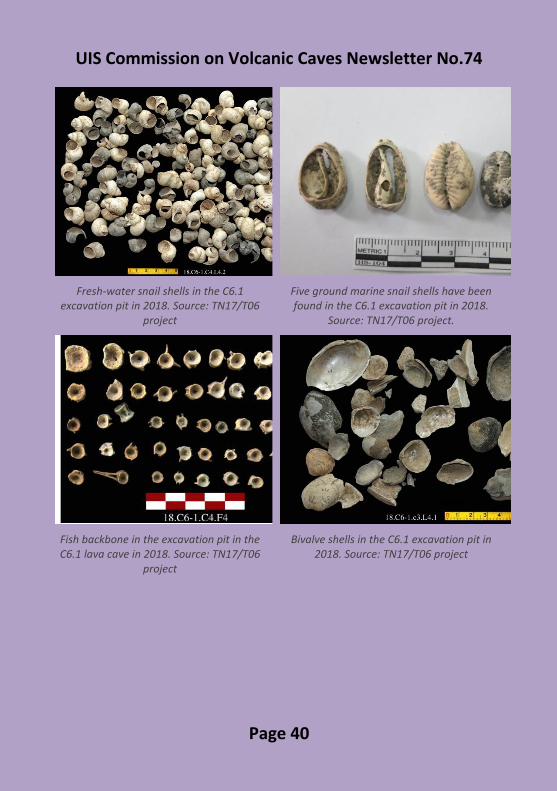
Preliminary excavation results were successful beyond expectation: the culture layer in the excavation pit (1.85m deep) is thickest of all archaeological sites excavated in The Central Highlands. Dozens of thousands of artefacts in the diverse archaeological relics have been collected, reflecting the long-term residence and temporary hunting sites of prehistoric people there. The three human skeletons in the C6.1 lava cave excavation pit have proved the burial relics (the way of burying the dead) of prehistoric people. Five ground marine mollusc shells have been collected, proved the interaction between local prehistoric people with the prehistoric marine ones. The results of the radiocarbon dating of the 14 charcoal samples collected from the excavation pit in the C6.1 lava cave show around 7,000 to 3,000 BP, equivalent to the Early Neolithic to the Early Metal [9;17].
In the most recent excavation of the project TN17/T06, conducted in March 2019, the earlier C6.1 excavation pit has been expanded wider and deeper. Besides many other important artefacts, another two ancient human skeletons have been excavated. They all are continuing to be researched in many fields, with traditional as well as modern methods to clarify the relationship between prehistoric residents in the past and modern people in the Central Highlands, Vietnam and Southeast Asia as well.

UIS Commission on Volcanic Caves Newsletter No.74
Page 38
The C6.1 lava cave pit and some typical artefacts excavated in 2018 and 2019
Cultural stratigraphical layer has not found in the South entrance of the C6.1. Photo: Luong
Thi Tuat
Eight cultural stratigraphical layers divided in the C6.1 excavation pit in 2018. Source:
TN17/T06 project
The prehistoric people chose the NE entrance of the C6.1 as their best home to live approx. 7,000-3,000 years BP. Photo: Luong Thi
Tuat

UIS Commission on Volcanic Caves Newsletter No.74
Page 39
Lava shelf suspended on the wall of the NW entrance of the C6.1 lava
cave. Photo: Luong Thi Tuat
The C6.1 excavation pit in the NE entrance of the C6.1 lava cave. Source: TN17/T06
project
Biface hand axe in the C6.1 excavation pit in 2018. Source: TN17/T06
UIS Commission on Volcanic Caves Newsletter No.74
Page 40
Fresh-water snail shells in the C6.1 excavation pit in 2018. Source: TN17/T06
project
Five ground marine snail shells have been found in the C6.1 excavation pit in 2018.
Source: TN17/T06 project.
Fish backbone in the excavation pit in the C6.1 lava cave in 2018. Source: TN17/T06
project
Bivalve shells in the C6.1 excavation pit in 2018. Source: TN17/T06 project

UIS Commission on Volcanic Caves Newsletter No.74
Page 41
The M1 skeleton first revealed in the C6.1 excavation pit in 2018. Source: TN17/T06
project
The entire M1 skeleton revealed in the C6.1 excavation pit in 2019. Photo: Luong Thi
Tuat
The skull of M2 skeleton has been restored
after the 2018 excavation. Photo: Nguyen Lan
Cuong
The M2 skeleton of a 4-year girl dating back 6,100BP, revealed in the C6.1 excavation pit
in 2018. Photo: Le Xuan Hung

UIS Commission on Volcanic Caves Newsletter No.74
Page 42
The M3 skeleton revealed in the C6.1 excavation pitin 2018. Photo: Le Xuan
Hung
The M4 skeleton just revealed in the C6.1 excavation pit in 2019. Photo: Luong Thi Tuat
3. Conclusion
As the most important and key/pillar heritage of Krongno Volcano Geopark, that now has been renamed Dak Nong Geopark, lava caves in Krongno area contain both natural and cultural heritage values: geological heritage, biological diversity as well as archaeological values.
Archaeological sites in the Krongno lava caves contain residence evidences of prehistoric people lived there. Especially, their skeletons firstly have been discovered in right the lava cave. The important discovery has recognized a new form of residence and ways of adaptation of the ancient people in The Central Highlands of Vietnam. The results of the C6.1 excavation clearly show the living of people, who occupied and owned the Krongno volcanic region, dated back to around 7,000 – 4,000 BP. These results make great contributions to understanding of regional history, exhibitions, conservation and tourism. In order to use these values efficiently, excavation and in-situ conservation should be considered as the best possible/optimal method, which might be applied to other sites as well.
The present study was supported by the project TN17/T06 of The Central Highlands Programme 2016-2020 stage.
UIS Commission on Volcanic Caves Newsletter No.74
Page 43
Authors
La The Phuc(1), Luong Thi Tuat(1), Nguyen Khac Su(2), Nguyen Lan
Cuong(2),Nguyen Thanh Tung(3), Vu Tien Duc(4), Le Xuan Hung(5), Phan
Thanh Toan(6), Pham Gia Minh Vu(1), Tran Minh Duc(1), Nguyen Trung
Minh(1)
Corresponding author: Luong Thi Tuat; e-mail:
(1): Vietnam National Museum of Nature, Vietnam Academy of Science and Technology
(2): Vietnam Archaeology Association (3): International tour-guide – Phu Gia Phat HCM. Co., Ltd (4): Institute of The Central Highlands, Vietnam Academy of Social
Sciences (5): Da Lat University (6): Vietnam Institute of Archaeology
Keywords: lava cave, geological heritage, artefact, prehistoric, skeleton.

UIS Commission on Volcanic Caves Newsletter No.74
Page 44
References
1. Nguyen Lan CUONG, 2018. The first human skeletons discovered in The Central Highlands: The milestone of Ancient Anthropology in Việt Nam. Vietnam Journal of Science and Technology. ISSN 1859-4794. Vol.715. N010A. p.44-46.
2. Tsutomu HONDA, Hiroshi Tachihara, 2015. Vietnam Volcanic Cave Survey. e-NEWSLETTER, UIS Commission on Volcanic caves, N069, April, 2015, p.11-12.
3. La The PHUC, 2008. Final project report “Investigation and research of geological heritage to build a geopark and environmental protection in the Trinh Nu waterfall area, CuJut district, Dak Nong province, Vietnam”. Archives: Vietnam Geological Museum, General Department of Geology and Minerals of Vietnam, Hanoi.
4. La The PHUC, 2008. Geoheritage of East and Southeast Asia. Chapter 9. Geoheritage of Vietnam, p. 251-291. CCOP. Printed by AMPANG PRESS SDN. BHD - 56100 Kuala Lumpur, Malaysia.
5. La The PHUC, Luong Thi Tuat, 2011. Some typical geoheritages in The Central Highlands and solutions for conservation and sustainable development. Proceedings APGN2, Hanoi, Vietnam, 2011.
6. La The PHUC, Luong Thi Tuat, Truong Quang Hai, Nguyen Thi Minh Ngoc, 2015. Caves in basalts in Krông Nô Area, Đăk Nông Province, Vietnam. VNU Journal of Science: Earth and Environmental Sciences. ISSN 2588-1094. Vol. 31, N02 (2015), p.36-46.
7. La The PHUC, Nguyen Khac Su, Vu Tien Duc, Luong Thi Tuat, Phan Thanh Toan, Nguyen Thanh Tung, Nguyen Trung Minh, 2017. New discovery of prehistoric archaeological remnants in volcanic caves in Krông Nô, Dak Nong Province. Vietnam Journal of Earth Sciences, 39(2), p.97-108.
8. La The PHUC et al., 2018. Geological values of lava caves in Krongno Volcano Geopark, Dak Nong, Vietnam. Vietnam journal of Earth sciences, Vol.40, N04; p. 299-319, Sep. 2018. ISSN 0866-7187. Available at: <http://www.vjs.ac.vn/index.php/jse/article/view/13101>. Date accessed: 30 Apr. 2019. doi:https://doi.org/10.15625/0866-7187/40/4/13101.

UIS Commission on Volcanic Caves Newsletter No.74
Page 45
9. La The PHUC et al., 2018. Reconnaissance and conservation of prehistoric archaeological relics in the C6.1 lava cave in Krongno, Dak Nong province. Proceedings of the international conference on International Integration of Conservation Opportunities and Challenges for Cultural Heritage Values. ISBN: 978-604-73-6535-7. Publishing House of the HCM City National University. p.297-309.
10. Truong Quang QUY, La The Phuc, 2010. Trinh Nữ waterfall geological heritage, Đắk Nông province. Journal of Geology; series B.35-36/2010; 131-139. Department of Geology and Minerals of Vietnam. Ha Noi.
11. Nguyen Khac SU, 2007. Prehistoric Archaeology of The Central Highlands. Publishing House of Education, Hanoi.
12. Nguyen Khac SU et al, 2017. New discoveries on archaeology in 2017. ISBN 9786049563966, Publishing House of Social Sciences, p.42-56 (including 4 articles).
13. Hiroshi TACHIHARA, Edition, NPO Vulcano Speleological Society, 2012. Vietnam Volcanic Cave Project Preliminary Report. 17~23 April 2012, Sakae Print Company. Japan.
14. Hiroshi TACHIHARA, Edition, NPO Vulcano Speleological Society, 2014. Vietnam Volcanic Cave Project Intermediate Report. 28 December 2013~4 January 2014, Sakae Print Company. Japan.
15. Hiroshi TACHIHARA, T. Honda, 2015. Vietnam Volcanic Cave Project Third Report. NPO Vulcano Speleological Society, 26 December 2014~3 January, Sakae Print Company, Japan.
16. Hiroshi TACHIHARA, Yuriko Chikano, 2018. Vietnam volcanic cave 2017 survey report. NPO Vulcano Speleological Society, Japan.
17. UIS Commission on Volcanic Caves, 2018. Ancient skeletons discovered in Krong No volcanic caves, Vietnam. e-NEWSLETTER, UIS Commission on Volcanic caves, N073, October, 2018, p.31.

UIS Commission on Volcanic Caves Newsletter No.74
Page 46
Lava caves in Heilongjiang and Jilin
provinces (NE China)
The Jingpohu Global Geopark in Heilongjiang province is formed by
volcanic rocks and is situated abou 110 km south of Mudanjiang city. The
volcanic zone is situated along the important NE-striking Dunhua-Mishan
fault at the eastern margin of the Eurasian Plate. Approximately 500 km2
of lava were emitted in several Pliocene-Holocene eruptive phases
between 780,000 and 2,500 years ago by 16 local craters, 4 of which are
accessible to visitors in the Crater National Forest Park at an elevation of
about 1,070 m a.s.l. in the NW corner of the park, also known as the
“Underground Forest”. The latter craters are the source of the lava that
has travelled down a 60 km long tributary valley towards the Mudanjiang
river in the SE and has finally blocked the river forming the famous
Diaosuilou waterfall, now being part of the touristic attractions of the
Geopark.
The Jingpohu Global Geopark; Photo: Michael Laumanns

UIS Commission on Volcanic Caves Newsletter No.74
Page 47
Wood & Zhang (2010) have briefly described the geological settings as
well as seven caves from the afore-mentioned lava flow:
- Weihuting Cave, upflow about 5.2 km from the Geopark’s entrance gate;
- Longyandongtian Cave (Dragon Rock Cave), 9.2 km from the entrance gate;
- Shenshui Cave (Driven Water Cave), 200 m SE of Longyandongtian Cave;
- Gubindong Cave (Ancient Ice Cave), 15 km from the entrance gate (3 roof collapses leading down into one cave);
- Jimei Cave (Sisters Cave), 13.3 km from the entrance gate (small roof collapse separating 2 cave segments);
- Kanlianmiying Cave (Anti-Japan Allied Army Secret Camp), 19 km from the entrance gate (has Chinese army remains).
- A short cave (nowadays called “Lion Cave”) connecting two of the lava emitting craters of the “Underground forest”.
Since 2010, a number of the afore-mentioned caves, as well as other cave sites, were made accessible to tourists by wooden walkways from the main road between the entrance of the Geopark and the “Underground Forest” craters. These tourist caves were visited by Russian, Dutch and German cavers in January 2019 and are described below in their order from SE to NW along the main road towards the craters. Regrettably, our team had no permission to do any surveying work. A proper cave documentation was suggested to the Geopark management though. Shenyang (Sheep) Cave is the first lava cave signposted on the main road to the craters. The cave is accessible by a wooden plankway with stairs. It is situated only 20 m from the road. The main (NW) entrance leads into a passage about 4 m wide and high which winds in southerly direction. After about 50 m another walkable roof collapse is reached and the cave bends towards the SE, passes a small daylight in the roof and finally ends in an ice plug. The cave is a cold-air trap and probably the ice remains during the entire year. Temperatures in the whole cave were well below the freezing point during our visit. There is beautiful aa rope lava on the floor as well as lava ledges along both walls. This cave does not match any of the descriptions provided by Wood & Zhang (2010). The length of the cave is estimated to be 150 m.

UIS Commission on Volcanic Caves Newsletter No.74
Page 48
Shenyang Cave; Photo: I. Ermakova.
Ice in Shenyang Cave; Photo: I. Ermakova.

UIS Commission on Volcanic Caves Newsletter No.74
Page 49
Nested Caves is a succession of short lava caves and signposted very close to the main road. The ensemble has short tube segments as well as a lava bridge. A nice lava fall is visible in one of the segments where liquid lava from a narrow side passage (leading to another entrance) flew down a ledge. Due to the instability of some of the cave segments, the Geopark has erected some artificial columns to support the roof of the cave. This site hasn’t been described by Wood & Zhang (2010).
Weihuting Lava Tunnel was described by Wood & Zhang (2010) as follows: “This cave can be found 100 m north of the 5.2 km point from the entrance gate to the crater forest park highway. The cave entrance is 7 m wide and 1.7 m high, although the passage height increases to 2.0 m farther into the cave. The ceiling is densely packed with conical lava stalactites. The wall surface is smooth and there are layers of protruding glaze. The floor is patterned pahoehoe. There are also floor driblets of different sizes. It is a spacious cavern, like a large hall.” During our visit in January 2019 we found the far reaching parts of the 50 m long cave free of frost and hosting a few hibernating bats. One Hilgendorf's Tube-nosed Bat (Murinus hilgendorfi) was seen as well as three unidentified small Vespertilionid bats.
Nested Cave; Photo: I. Ermakova.

UIS Commission on Volcanic Caves Newsletter No.74
Page 50
Lava Tunnel lies immediately left of the main road. It is a touristic show cave with a ticket office, visitor facilities, typical colourful electric lighting, and a wooden walkway throughout the whole SE (downstream) segment of the cave, which is about 200 m long. The small entrance pit is fitted with stairs and leads into a passage 4-7 m in width and 1.5-4 m in height. The SE cave segment branches around two lava columns and leads to another entrance fitted with a staircase and a metal door. There are several beautiful lava ledges along both walls and aa rope lava on the floor in places. The temperatures in the cave are moderate and the site appears to be one of the most important bat hibernation places in the Geopark. At least 20 Murinus hilgendorfi, party in clusters, were noted. There were also 3 individuals of a Plecotus species, probably Ognev's long-eared bat (Plecotus ognevi). Also, the same small Vespertilionid species like in Weihuting Lava Tunnel was seen. The NW (upstream) cave segment starts somewhat smaller (2 m wide and high) but the staff from the Geopark did not wish us to enter this gallery, which is not open to tourists. It is unclear whether “Lava Tunnel” has already been described by Wood & Zhang (2010) - possibly it is identical with Longyandongtian Cave (Dragon Rock Cave) or Jiemei Cave (Sisters Cave).
Lava Tunnel Jingpohu; Photo: Michael Laumanns

UIS Commission on Volcanic Caves Newsletter No.74
Page 51
Ancient Ice Cave (Gubingdong Cave) was described by Wood & Zhang (2010) under the name Gubingdong Cave (Ancient Ice Cave) as follows: “Access to this cave lies about 15 km up-flow from the entrance gate of the crater forest park highway. There are 3 collapse pits overlying a cave that branches in two, the northern branch being known as Gubingdong. This cave has a passage diameter of about 8 m. In summer surface water seeps into the cave through ceiling cracks and runs to the low-lying places in the cave, where it freezes in winter. The ice remains frozen through the summer.” Nowadays the large main roof collapse of this cave is made accessible by a wooden pathway from the main road towards the craters. The collapse is situated about 200 m from the road. The main (northern) segment of the Cave (called “Foggy Cave”) is about 200 m long and was the most spacious lava cave seen by us during our visit in January 2019 (8-10 m wide and 6-8 m high). The floor of Foggy Cave is entirely covered with partly large boulders. The cave segment leads to another entrance further north. The fog inside the cave, mentioned on a display, was not noticed by us during our visit in winter. Beside the afore-mentioned ice lake in the short southern cave segment there is a short section of subsidiary narrow lava tunnels at the SW side of the main roof collapse (called “Fairy Cave”).
Central Roof Collapse of Ancient Ice Cave with Wooden
Walkways; Photo: H. Steiner.

UIS Commission on Volcanic Caves Newsletter No.74
Page 52
Underground Lava Fall hasn’t been described by Wood & Zhang (2010). It is situated about 200 m from the main road towards the “Underground forest” and resembles a short lava cave segment (6-8 m wide and 4-6 m high) of only 20 m length. However, it has a beautiful lava fall over a 3 m high step that is worth a visit. Lion Cave is located in the “Underground forest” crater IV has been mentioned by Wood & Zhang (2010), who state that it is possible to walk from one crater (crater IV) to another (crater III) through the cave. However, the cave is merely a large rock-shelter that can be entered from crater IV, with no connection to crater III. There are steps and a wooden walkway. About 150 km further SW from the Jingpohu Geopark and 80 km east of
Baishan city the active Tianchi (Baitoushan) volcano in Changbaishan
(Jilin province) forms part of the border to North Korea. It features a scenic
summit caldera, about 5 km in diameter, filled with a 9.8 km2 lake at 2.189
m a.s.l. The lake is up to 384 m deep. The area is a popular touristic site
for Chinese but the local authorities are still reluctant to receive foreigners
close to the border. On the north slope of the volcano, in an area restricted
to visitors, Chinese geologists have surveyed a 560 m long lava tube,
called Silidong. Their article (Zhengquan et al. 2015) has a detailed cave
map and describes the cave insofar as special, as recent pyroclastic flows
have entered the cave through one or more entrances leaving unique ash
deposits inside the cave. Apart from Silidong no other lava tubes became
known from the Tianchi volcano.
The afore-mentioned brief article of Wood & Zhang (2010) provides the
best available guidance on volcanic caves in China so far. Generally
speaking, the state of documentation of China’s volcanic caves is entirely
insufficient. This is partly a result of the fact that Chinese key institutions
exclusively deal with karst caves and have not yet developed any interest
in volcanic caves. The longest Chinese lava tube known today is 729 m
long Djin Fu Dong in Yunnan province, close to the Myanmar border
(Zhalov 2011, profile). In consequence, it is expected that important
discoveries related to volcanic caves in China are possible in the future.
Michael Laumanns
UIS Commission on Volcanic Caves Newsletter No.74
Page 53
References
Wood, C. & Zhang, H. (2010): Volcanic Centres and Lava Caves of China.
- Proceed. 14th Sympos. on Volcanospeleology, p. 123-129; Undarra
Natonal Park (Australia).
Zhalov, A. (2011): CINA. Spedizione Bulgaro-Cinese a Golingoshan. -
Speleologia SSI, 65, p. 87-88; Bologna.
Zhengquan, C.; Haiquan, W.; Yongshun, L.; Tilling, R.I.; Jiandong, X.;
Chengzhi, W. & Baofeng, N. (2015): A historical pyroclastic flow
emplaced within a pre-existing Pleistocene lava tube: Silidong, Tianchi
Volcano, Changbaishan, northeastern China. - Bull. of Volcanology, 77
( 6).

UIS Commission on Volcanic Caves Newsletter No.74
Page 54
Installation of pāhoehoe by lava tubes and tunnels:
concept and volcano-geomorphological signatures
This article, authored by Michel Detay and Björn Hróarsson has recently been
published in Géomorphologie Vol 24 No.4. It contains much that will be of interest
to members of the commission, and the English abstract is included below. The
full article, in French, can be found at
https://journals.openedition.org/geomorphologie/12557. (Ed.).
English Abstract
Pāhoehoe and ‘a‘ā basaltic lava flows are common on volcanic islands such as
Hawaii, Reunion Island and Iceland. They are present in all LIP and giant lava flows
identified in planetary volcanology. In terms of both areal coverage and total
volume, pāhoehoe flows dominate basaltic lavas in subaerial and submarine
environments on Earth. Several processes for pāhoehoe lava flow emplacement
have been identified, at different scales, from the extrusion of small lobes to the
formation of giant flows.
Thanks to the dynamics of geological fluids, we put forward a new paradigm to
explain the emplacement of pāhoehoe lavas. The kinematics of the fluid
mechanics is expressed through (immaterial) steam tubes that go on to become
lava tubes and then lava tunnels (TTL). Lava tunnels, once considered a
speleological curiosity, have been established to play a central role in the
dynamics of geological fluids. The anastomosing network of TTL is integral to the
pāhoehoe’s placement dynamics, both in open channel flows and pipe flows
(inflation). The pāhoehoe fluid is considered to be a reactor in its own right. This
fluid harbours numerous physicochemical reactions (including fractional
crystallization, exsolution, segregation, coalescence and buoyancy), and is
characterized by various interfaces and transition zones between the different
constantly changing states of matter (number of phases, Newtonian fluid,
Bingham and Herschel-Bulkley complex fluids). Various volcano-
geomorphological indicators, at various observation scales on the surface and
underground, reveal the dynamics of emplacement and make it possible to
identify them in current and ancient flows. The paradigm of emplacement by TTL
is crucial to both pāhoehoes and constituting LIP.