universiti putra malaysia improving classification...
TRANSCRIPT

UNIVERSITI PUTRA MALAYSIA
IMPROVING CLASSIFICATION OF REMOTELY SENSED DATA USING BEST BAND SELECTION INDEX AND CLUSTER LABELLING
ALGORITHMS
TEOH CHIN CHUANG.
FK 2005 49

IMPROVING CLASSIFICATION OF REMOTELY SENSED DATA USING BEST BAND SELECTION INDEX AND CLUSTER LABELLING ALGORITHMS
TEOH CHIN CHUANG
Thesis Submitted to the School of Graduate Studies, Universiti Putra Malaysia, in Fulfilment of the Requirements for the Degree of Doctor of Philosophy
May 2005

Specially Dedicated To:
My Beloved Wife,
Ong Keat Khim
My Beloved Parents,
Teoh Gin Soon and Hoo Siew Eng
Abstract of the thesis presented to the Senate of Universiti Putra Malaysia in fulfilment of the requirements for the degree of Doctor of Philosophy
IMPROVING CLASSIFICATION OF REMOTELY SENSED DATA USING BEST BAND SELECTION INDEX AND CLUSTER LABELLING ALGORITHMS
BY
TEOH CHIN CHUANG
May 2005
Chairman: Professor Shattri Mansor, PhD
Faculty: Engineering
Methods for improving supervised and unsupervised classification of remotely sensed data
were developed in this study. Supervised classification of remotely sensed data requires
systematic collection of training samples for classes of interest. Image visual interpretation
is important in training samples collection because it incorporates association information
of surrounding pixels, such as texture and context, hence making the training samples
collection process more easy and accurate. Once training samples for each class are
collected, the training statistics for each class and band are extracted to select those bands,
which are most effective in discriminating each class of information fiom all others for
classification. In remote sensing application, deciding the best band combination for
image visualization and classification is relatively difficult and time consuming. In
addition, the best band selected for image classification is not necessarily the best for
classification.

A Best Band Selection Index (BBSI) algorithm was developed which is capable of
selecting the best band combination for image visualization and supervised classification.
This BBSI is calculated by two components, one based on class mean (or cluster mean)
difference and the other based on correlation coefficients. Using Landsat Thematic
Mapper (TM) and ModisIAster Airborne Simulator (hMSTER) images as the test
datasets, the BBSI algorithm was compared to the Optimum Index Factor (OIF) algorithm
in selection of the best three-band combination for image visualization. The comparison
results between BBSI and OIF indicated that, both algorithms correctly predicted the best
three-band combination that provided useful information for image visualization in the
Landsat TM dataset. However, both algorithms tested on MASTER dataset produced
different results. The image quality of band combination selected by BBSI was smoother
and better than OIF.
The BBSI was also compared to the Jefieys-Matusita distance (JM-distance) algorithm in
selection of the best four-band combination for supervised classification of Landsat TM
and MASTER datasets. The comparison results between BBSI and JM-distance showed
that, both algorithms accurately selected the best four-band combination that yielded the
highest overall accuracy classification map with value of 91% in the Landsat TM dataset.
Meanwhile, the comparison results in the MASTER dataset showed that, the overall
accuracy classification map for band combination selected by BBSI with value of 89.7%
was slightly higher than band combination selected by JM-distance with value of 89.2%.

Umpervised classification of remotely sensed data consists of cluster generation and
cluster labelling steps. A method was developed to improve the cluster generation and
clusters labelling processes in unsupervised classification of the Landsat TM and
MASTER datasets. In cluster generating process, the developed BBSI algorithm was used
to select the best band combination for generating cluster by using Iterative self-
Organizing Data Analysis (ISODATA) technique. The cluster generation results showed
that, the BBSI accurately selected the best four-band combination generating very low
mixed classes of clusters.
In cluster labelling process, a cluster labelling algorithm based on calculation of
minimum-distance (MD) between cluster mean and class mean was developed to label the
clusters. This algorithm was compared to co-spectral plot method for labelling clusters the
clusters generated in Landsat TM dataset. The comparison results show that, the clusters
labelled by the cluster labelling algorithm were the same as using co-spectral plot. The
cluster labelling algorithm was also compared to maximum-likelihood supervised
classifier in the production of classification map for MASTER dataset. The comparison
showed that, the accuracy of the unsupervised classification map with value of 88.4% that
was generated by using the cluster labelling algorithm was slightly more than the
maximum-likelihood supervised classification map with value of 87.5%. The advantage of
the cluster labelling algorithm compared to co-spectral plot and maximum-likelihood
classifier was the algorithm provided a rapid production of high accuracy classification
map.

Abstrak tesis yang dikemukakan kepada Senat Universiti Putra Malaysia sebagai memenuhi keperluan untuk ijazah Doktor Falsafah
PEMBAIKAN PENGKELASAN DATA REMOTE SENSING MENGGUNAKAN ALGORITMA INDEKS PEMILIHAN JALUR TERBAIK DAN ALGORITMA
PELABELAN KELOMPOK
TEOH CHIN CHUANG
Mei 2005
Pengerusi: Profesor Sbattri Mansor, PhD
Fakulti: Kejuruteraan
Kaedah pembaikan pengkelasan yang terselia dan pengkelasan yang tidak terselia bagi
data remote sensing telah dibangunkan di dalam kajian ini. Pengkelasan yang terselia bagi
imej remote sensing memerlukan pengumpulan sampel-sampel latihan untuk kelas-kelas
yang dirninati secara teratur. Pentafiiran imej secara penglihatan adalah penting di dalam
pengumpulan sampel-sampel latihan kerana cara ini mengambilkira maklumat berkaitan
seperti tekstur clan konteks untuk piksel-piksel di sekeliling. Ini akan membuat proses
pengumpulan sampel-sampel lebih mudah dan jitu Selepas mengumpulkan sarnpel-
sampel latihan, rnaklumat statistik sampel-sampel latihan bagi setiap kelas dan jalur
diperolehi dan digunakan untuk memilih jalur-jalur yang paling berkesan. Jalur-jalur
dipilih ini dapat membezakan setiap kelas dengan berkesan di dalam pengkelasan imej.
Dalam aplikasi remote sensing, pemilihan kombinasi jalur-jalur yang baik untuk
penglihtan dan pengkelasan imej adalah sukar dan membazirkan masa. Tambahan pula,
jalur-jalur yang terpilih untuk penglihatan imej tidak semestinya sesuai untuk pengkelasan
imej. Satu algoritma Indeks Pernilihan Jalur Terbaik [Best Band Selection Index (BBSI)]
telah dibangunkan, di mana ia berupaya memilih kombinasi jalur-jalur yang paling baik
untuk penglihatan dan pengkelasan imej. BBSI ini dikira oleh dua komponen, satu
berdasarkan perbezaan purata kelas (atau purata kelompok) dan satu lagi ialah berdasarkan
pekali sekaitan. Dengan menggunakan imej-imej 'Landsat Thematic Mapper' (TM) dan
'ModisIAster Airborne Simulator' (MASTER) sebagai dataset ujian, BBSI telah
dibandingkan dengan algoritma Faktor Indeks Optimum [Optimum Index Factor (OIF)] di
dalarn pemilihan kombinasi tiga-jalur yang paling baik untuk penglihatan imej.
Keputusan-keputusan daripada perbandingan di antara BBSI and OIF menunjukkan
bahawa, kedua-dua algoritma dapat merarnalkan kombinasi tiga-jalur dengan tepat, di
mana kombinasi jalur-jalur tersebut dapat membekalkan informasi yang berguna untuk
pentafsiran imej Landsat TM dengan cara penglihatan. Walau bagairnanapun, keputusan
yang berlainan dihasilkan apabila kedua-dua algoritma tersebut diuji pada dataset
MASTER. Kualiti imej yang menggunakan kombinasi tiga-jalur yang dipilih oleh BBSI
adalah lebih licin dan baik daripada OIF.
BBSI juga dibandingkan dengan algoritma Jarak Jeffreys-Matusita (Jarak-JM) di dalam
pemilihan kombinasi empat-jalur yang paling baik untuk pengkelasan data Landsat TM
dan MASTER secara terselia. Keputusan perbandingkan di antara BBSI and Jarak-JM
menunjukkan bahawa, kedua-dua algoritma dapat memilih kombinasi empat-jalur dengan
tepat, di mana kombinasi jalur-jalur dipilih itu dapat menghasilkan peta pengkelasan yang
paling baik dengan kejituan keseluruhan 91% untuk dataset Landsat TM. Manakala,
menunjukkan bahawa, keputusan perbandingan untuk dataset MASTER
vii

kejituan keseluruhan yang dipilih oleh BBSI adalah 89.7% dan kejituan ini adalah lebih
tinggi sedikit daripada Jarak-JM yang mempunyai nilai 89.2%.
Pengkelasan yang tidak terselia bagi data remote sensing terdiri daripada langkah-
langkah penjanaan kelompok dan pelabelan kelompok. Satu kaedah telah dibangunkan
untuk pembaikan proses-proses penjanaan kelompok dan pelabelan kelornpok di dalam
pengkelasan tidak terselia untuk dataset Landsat TM dan MASTER. Di dalam proses
penjanaan kelompok, algoritma BBSI digunakan untuk memilih kombinasi jalur-jalur
terbaik untuk menjanakan kelompok-kelompok dengan menggunakan teknik Analisis
Data Aturan-Diri Berulang pterative Self-organizing Data Analysis (ISODATA)].
Keputusan-keputusan penjanaan kelompok menunjukkan bahawa, BBSI dapat memilih
kombinasi empat-jalur dengan tepat, di mana jalur-jalur dipilih dapat menghasilkan
kelompok-kelompok yang kurang bercampur kelas.
Di dalam proses pelabelan kelompok, satu algoritma pelabelan kelompok berdasarkan
pengiraan jarak-minimum di antara purata kelompok dan purata kelas telah dibangunkan
untuk melabelkan kelompok-kelompok. Algoritma hi telah dibandingkan dengan
kaedah plot co-spektrum untuk melabelkan kelompok-kelompok yang dihasilkan di
dalam dataset Landsat TM. Keputusan-keputusan daripada perbandingan menunjukkan
bahawa, kelompok-kelompok yang dilabelkan oleh algoritma pelabelan kelompok
adalah sama dengan menggunakan plot co-spektrum. Algoritma pelabelan kelompok
juga dibandingkan dengan pengkelas kebolehjadian maksimum di dalam penghasilan
peta pengkelasan untuk dataset MASTER. Keputusan-keputusan daripada perbandingan
... Vlll

menunjukkan bahawa, kejituan keseluruhan peta pengkelasan yang dihasilkan dengan
menggunakan algoritma pelabelan kelompok memberi nilai 88.4% yang adalah sedikit
lebih tinggi daripada peta pengkelasan yang dihasilkan oleh pengkelas kebolehjadian
maksimum yang memberi nilai 87.5%. Kelebihan algoritma pelabelan kelompok
dibandingkan dengan plot co-spektrutn dan pengkelas kebolehjadian maksimum blah
algoritma tersebut dapat menghasilkan peta pengkelasan yang mempunyai kejituan
tinggi dengan cepat.

ACKNOWLEDGEMENTS
My heart-felt gratitude goes to my supervisor, Professor Dr. Shattri Mansor for his
guidance, technical assistance, encouragement and support that has made this thesis
possible.
I would like to extend my appreciation to Associate Professor Dr. Abdul Rashid
Mohamed Shariff, Associate Professor Dr. Noordin Ahrnad and Dr. Radzali Mispan for
their kind cooperation and assistance through out my study and also to Malaysia Centre
for Remote Sensing (MACRES) for providing the remotely sensed dataset.
Finally, I wish to convey my special thanks to my wife and family members, who had
contributed and supported me toward the successfid completion of this study.
I certify that an Examination Committee met on 15 May 2005 to conduct the final examination of Teoh Chin Chuang on his Doctor of Philosophy thesis entitled "Improving Classification of Remotely Sensed Data Using Best Band Selection Index and Cluster Labelling Algorithms" in accordance with Universiti Pertanian Malaysia (Higher Degree) Act 1980 and Universiti Pertanian Malaysia (Higher Degree) Regulations 1981. The Committee recommends that the candidate be awarded the relevant degree. Members of the Examination Committee are as follows:
Ir. Mohd Razali Abdul Kadir, PhD Associate Professor Faculty of Engineering Universiti Putra Malaysia (Chairman)
Abd Rahman Ramli, PhD Associate Professor Faculty of Engineering Universiti Putra Malaysia (Internal Examiner)
Helmi Zulhaidi Mohd. Shafri, PhD Lecturer Faculty of Engineering Universiti Putra Malaysia (Internal Examiner)
Mohd. Ibrahim Seeni Mohd., PhD Professor Faculty of Geoinformation Science and Engineering Universiti Teknologi Malaysia (External Examiner)
E ~ S ~ ~ R A H M A T ALI, PhD ~ r o f e s s d r l ~ k ~ u t ~ Dean School of Graduate Studies Universiti Putra Malaysia

This thesis submitted to the Senate of Universiti Putra Malaysia has been accepted as hlfilrnent of the requirement for the degree of Doctor of Philosophy. The members of the Supervisory Committee are as follows:
Shattri Mansor, PhD Professor Faculty of Engineering Universiti Putra Malaysia (Chairman)
Abdul Rashid Mohamed Shariff, PhD Associate Professor Faculty of Engineering Universiti Putra Malaysia (Member)
Noordin Ahmad, PhD Associate Professor Faculty of Engineering Universiti Putra Malaysia (Member)
AINI IDERIS, PhD Professor1 Dean School of Graduate Studies Universiti Putra Malaysia
Date:
xii

DECLARATION
I hereby declare that the thesis is based on my original work except for quotations and citations which have been duly acknowledged. I also declare that it has not been previously or concurrently submitted for any other degree at UPM or other institutions.
TEOH CHIN CHUANG
. . * Xlll

TABLE OF CONTENTS
DEDICATION
ABSTRACT
ABSTRAK
ACKNOWLEDGEMENTS
APPROVAL
DECLARATION
LIST OF TABLES
LIST OF FIGURES
LIST OF ABBREVIATIONS
CHAPTER
INTRODUCTION
1.1 Problem Statement
1.2 Objectives of Study
1.3 Scope of Study
LITERATURE REVIEW
2.1 Landsat Thematic Mapper (TM) Data
2.2 ModisIAster Airborne Simulator (MASTER) Data
2.3 Supervised Classification
2.3.1 Training Samples Collection
2.3.2 Bands Selection for Image Classification
2.3.3 Classification Algorithms
2.3.4 Summary of Supervised Classification
2.4 Unsupervised Classification
2.4.1 Cluster Generation
2.4.2 Cluster Labelling
2.4.3 Summary of Unsupervised Classification
2.5 Accuracy Assessment
Page . . 11 ... 111
vi
X
xi
xiii
xvii
xxiii
xxix
xiv

METHODOLOGY
3.1 Study Areas and Data Sources
3.2 Best Bands Selection for Image Visualization and Supervised Classification 3.2.1 Best Band Selection Index (BBSI) Algorithm
3.2.2 Best Three Bands Selection for Image Visualization Using the BBSI Algorithm
3.2.3 Best Four Bands Selection for Supervised Classification Using the BBSI Algorithm
3.2.4 Development of BASIC Computer Program to Select the Best Band Combination for Image Visualization and Supervised Classification
3.3 Cluster Generation and Labelling in Unsupervised Classification
3.3.1 Best Bands Selection for Generating Cluster Using the BBSI Algorithm
3.3.2 Labelling the Cluster Using the Cluster Labelling Algorithm
3.3.3 Development of BASIC Computer Program for Selecting the Best Band Combination in Cluster Generation and Labelling the Cluster Generated in Unsupervised Classification
RESULTS AND DISCUSSIONS
4.1 Results of Supervised Classification of Landsat TM and MASTER Datasets
Best Three-Band Combination Selection Based on BBSI for Image Visual Interpretation of Landsat TM and MASTER Datasets Comparison of Best Band Selection Index (BBSI) and Optimum Index Factor (OIF) Algorithms in Selection of the Best Three-Band Combination for Image Visualization of Landsat TM and MASTER Datasets
Best Four-Band Combination Selection Based on BBSI for Image Supervised Classification of Landsat TM and MASTER Datasets Comparison of the Ranking Results Between BBSI and Overall Accuracy Classification for Landsat TM and MASTER Datasets Comparison of Best Band Selection Index (BBSI) and JefEeys-Mastusita Distance (JM-distance) Algorithms in Best Band Combination Selection for Supervised Classification
4.1.6 Results of the BASIC Computer Program to Select the Best Band Combination for Image Visualization and Supervised Classification of Landsat TM and MASTER datasets
4.2 Results of Unsupervised Classification of Landsat TM and MASTER Datasets
4.2.1 Best Four-Band Combination Selection Based on BBSI for Generating Clusters in Unsupervised Classification
4.2.2 Cluster Labelling Based on Minimum Distance (MD) Between Cluster Mean and Class Mean for Landsat TM Dataset
4.2.3 Cluster Labelling Based on Minimum Distance (MD) Between Cluster Mean and Class Mean for MASTER Dataset
4.2.4 Results of the BASIC Computer Program for Selecting the Best Bands Combination in Cluster Generation and Labelling the Cluster Generated in Unsupervised Classification of Landsat TM and MASTER Datasets
CONCLUSIONS AND RECOMMENDATIONS
5.1 Conclusions
5.2 Recommendations
REFERENCES/BIBLIOGRAPHY
APPENDICES
A. 1 BASIC Computer Program for Best Band Combination Selection in Image Visualization and Supervised Classification
A.2 BASIC Computer Program for Best Band Combination Selection in Cluster Generation and Labelling the Cluster in Unsupervised Classification
BIODATA OF THE AUTHOR
xvi
LIST OF TABLES
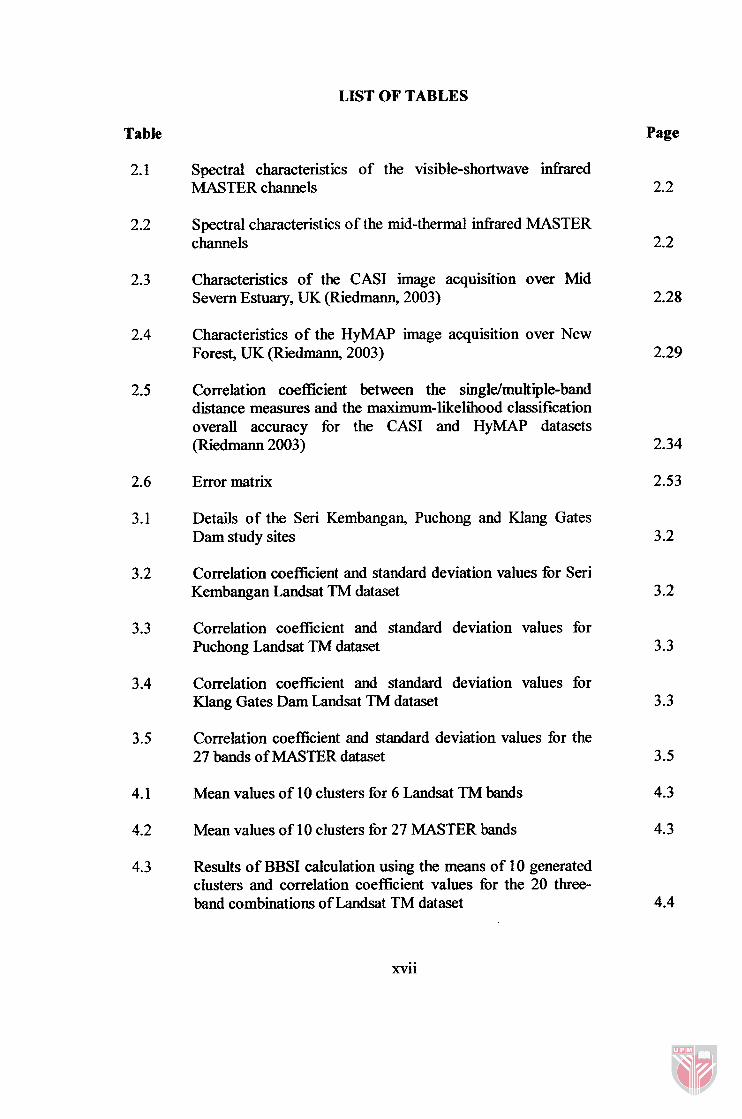
Table Page
Spectral characteristics of the visible-shortwave infixed MASTER channels
Spectral characteristics of the mid-thermal hfkared MASTER channels
Characteristics of the CASI image acquisition over Mid Severn Estuary, UK (Riedmann, 2003)
Characteristics of the HyMAP image acquisition over New Forest, UK (Riedmann, 2003)
Correlation coeficient between the singlefmult iple-band distance measures and the maximum-likelihood classification overall accuracy for the CASI and HyMAP datasets (Riedmann 2003)
Error matrix
Details of the Seri Kembangan, Puchong and Klang Gates Dam study sites
Correlation coefficient and standard deviation values for Seri Kembangan Landsat TM dataset
Correlation coefficient and standard deviation values for Puchong Landsat TM dataset
Correlation coefficient and standard deviation values for Klang Gates Dam Landsat TM dataset
Correlation coefficient and standard deviation values for the 27 bands of MASTER dataset
Mean values of 10 clusters for 6 Landsat TM bands
Mean values of 10 clusters for 27 MASTER bands
Results of BBSI calculation using the means of 10 generated clusters and correlation coefficient values for the 20 three- band combinations of Landsat TM dataset
xvii

Results of BBSI calculation using the means of 15 generated clusters and correlation coefficient values for the 20 three- band combinations of Landsat TM dataset
BBSI values of the top 15 and last 15 ranks in the 2925 three- band combinations for MASTER dataset
BBSI results for the 20 three-band combinations of Landsat TM dataset
OIF results for the 20 three-band combinations of Landsat TM dataset
Results of BBSI for first 15 and last 15 ranks among the 2925 three-band combinations of MASTER dataset
Results of OIF for first 15 and last 15 ranks among the 2925 three-band combinations of MASTER dataset
Ranking results based on sum of mean cluster differences for the 50 MASTER bands
Ranking results based on standard deviation for the 50 MASTER bands
Classes mean values of training samples for urban, water, cleared land, forest, rubber and oil palm class of 6 Landsat TM bands
Classes mean values of training samples for paddy, water, rubber, cleared land and urban class of 27 MASTER bands
Results of BBSI calculation based on the classes mean differences and correlation coefficient values for the 15 four- band combinations of Landsat TM dataset
Results of BBSI calculation based on the classes mean differences and correlation coefficient values for the top 10 and last 10 in 17550 combinations for MASTER dataset
Error matrix of the classification results using six classes of training samples and band combination TM 1, 3, 4 and 5 for Landsat TM dataset
xviii

Error matrix of the classification results using five classes of training samples and band combination MS 7, 1 1, 20 and 24 for MASTER dataset
BBSI and overall accuracy results of the 15 four-band combinations for Landsat TM dataset
User's and producer's accuracies report for band combination TM 1,3,4 and 5 of Landsat TM dataset
User's and producer's accuracies report for band combination TM 1,2,3 and 7 of Landsat TM dataset
BBSI and overall accuracy results of the fist 10 and last 10 four-band combinations for MASTER dataset
User's and producer's accuracies report for band combination MS 7 , l l , 20 and 24 of MASTER dataset
User's and producer's accuracies report for band combination MS 44,45,46, and 47 of MASTER dataset
Sum of the correction coefficient and overall accuracies for four-band combinations that were ranked first and last in term of BBSI for Landsat TM ans MASTER dataset
Overall accuracy, BBSI and JM-distance ranking results for the 15 four-band combinations of Landsat TM dataset
Overall accuracy, BBSI and JM-distance ranking results for the 20 four-band combination samples of MASTER dataset
Mean values of 15 clusters for Seri Kembangan Landsat TM dataset
Mean values of 15 clusters for Puchong Landsat TM dataset
Mean values of 15 clusters for Klang Gates Dam Landsat TM dataset
Mean values of 10 clusters for Jertih MASTER dataset
Results of BBSI calculation based on the means of 15 generated clusters and correction coefficient values for the 15 four-band combinations of Seri Kembangan Landsat TM dataset

Results of BBSI calculation based on the means of 15 generated clusters and correction coefficient values for the 15 four-band combinations of Puchong Landsat TM dataset
Results of BBSI calculation based on the means of 15 generated clusters and correction coefficient values for the 15 four-band combinations of Klang Gates Dam Landsat TM dataset
Results of BBSI calculation based on the means of 10 generated clusters and correction coefficient values for the four-band combinations ranked top 10 and last 10 in 17550 combinations for Jertih MASTER dataset
The 15 clusters means of bands TM 3 and 4 for Seri Kembangan Landsat TM dataset
The 15 clusters means of bands TM 3 and 4 for Puchong Landsat TM dataset
The 15 clusters means of bands TM 3 and 4 for Klang Gates Dam Landsat TM dataset
Class mean values for 6 TM bands in Seri Kembangan Landsat TM dataset
Class mean values for 6 TM bands in Puchong Landsat TM dataset
Average class mean values for each class and TM band calculated fiom class means in Seri Kembangan and Puchong Landsat TM datasets
Results of calculation minimum distance between cluster mean and class mean (MD~l,~, to ,I,) and clusters labelling for all 15 clusters in Seri Kembangan Landsat TM dataset
Results of calculation minimum distance between cluster mean and class mean (MDclUfia to ,hS) and clusters labelling for all 15 clusters in Puchong Landsat TM dataset
Results of calculation minimum distance between cluster mean and class mean (MDclUaa to ,I,,) and clusters labelling for all 15 clusters in Klang Gate Dam Landsat TM dataset

Summaries of the clusters labelling results for Seri Kembangan, Puchong and Klang Gates Dam Landsat TM datasets
Results of producer's and user's accuracies and overall accuracy of unsupervised classification map for Seri Kembangan Landsat TM dataset
Results of producer's and user's accuracies and overall accuracy of unsupervised classification map for Puchong Landsat TM dataset
Results of producer's and user's accuracies and overall accuracy of unsupervised classifcation map for Klang Gates Dam Landsat TM dataset
The results of clusters labelling by using co-spectral plot method for Seri Kembangan, Puchong and Klang Gates Dam Landsat TM datasets
The 10 clusters mean values for bands MS 3, 7, 8 and 22 of Jertih MASTER dataset
Paddy, water, rubber, cleared land and urban class mean values for bands MS 3,7,8 and 22 of Jertih MASTER dataset
Results of calculation of minimum distance between cluster mean and class mean (MDC1"ga ,I,) and clusters labelling for all 10 clusters which were generated by using band combination MS 3,7,8 and 22 and ISODATA technique
Error matrix of unsupervised classification map which was generated by using band combination MS 3, 7, 8 and 22, ISODATA technique and cluster labelling algorithm
Error matrix of supervised classification map which was generated by using band combination MS 3 ,7 ,8 and 22, five classes of training samples and maximum likelihood classifier
Results of calculation of minimum distance between cluster mean and class mean (MDc1"ga and clusters labelling for all 10 clusters which were generated by using band combination MS 20,21,22 and 23 and ISODATA technique

Error matrix of unsupervised classification map which was generated by using band combination MS 20, 21, 22 and 23, ISODATA technique and cluster labelling algorithm

LIST OF FIGURES
Figure
1.1
2.1
2.2
2.3
Page
1.2
2.4
2.10
Pattern recognition model
Conceptual of Hughes phenomenon (Hughes, 1968)
Bar graph spectral plots of data (Jensen, 2005)
a) Cospectral mean vector plots of 49 clusters. b) The logic for increasing numeral size and thickness along the z-axis. c) The introduction of band 2 information scaled according to size and thickness along the z-axis (Hodgson and Plews, 1989)
Two-dimensional feature space plots of four pairs of Landsat TM data. a) TM bands 1 and 3. b) TM bands 2 and 4. c) TM bands 3 and 4. d) TM bands 4 and 5 (Jensen, 2005)
Plot of the Landsat TM training statistics for five classes measured in TM bands 4 and 5 displayed as cospectral parallelepipeds (Jensen, 2005)
Simple parallelepiped displayed in pseudo three-dimensional space. Each of the eight corners represents a unique x, y, z coordinate corresponding to a lower or upper threshold value of the training sample (Jensen, 2005)
Development of the three-dimensional parallelepipeds of the five training classes derived fiom Landsat TM data (Jensen, 2005)
The basic problem in remote sensing pattern recognition classification. The dark areas of both distributions identitj. potential classification error (Jensen, 2005)
Scatter plots of single-band distance measure against maximum- likelihood classification overall accuracy for the CASI dataset (Riedmann, 2003)
Scatter plots of single-band distance measure against maximum- likelihood classification overall accuracy for the HyMAP dataset (Riedmann, 2003)
Scatter plots of multiple-band distance measure against maximum-likelihood classification overall accuracy for the CASI dataset (Riedmann 2003)
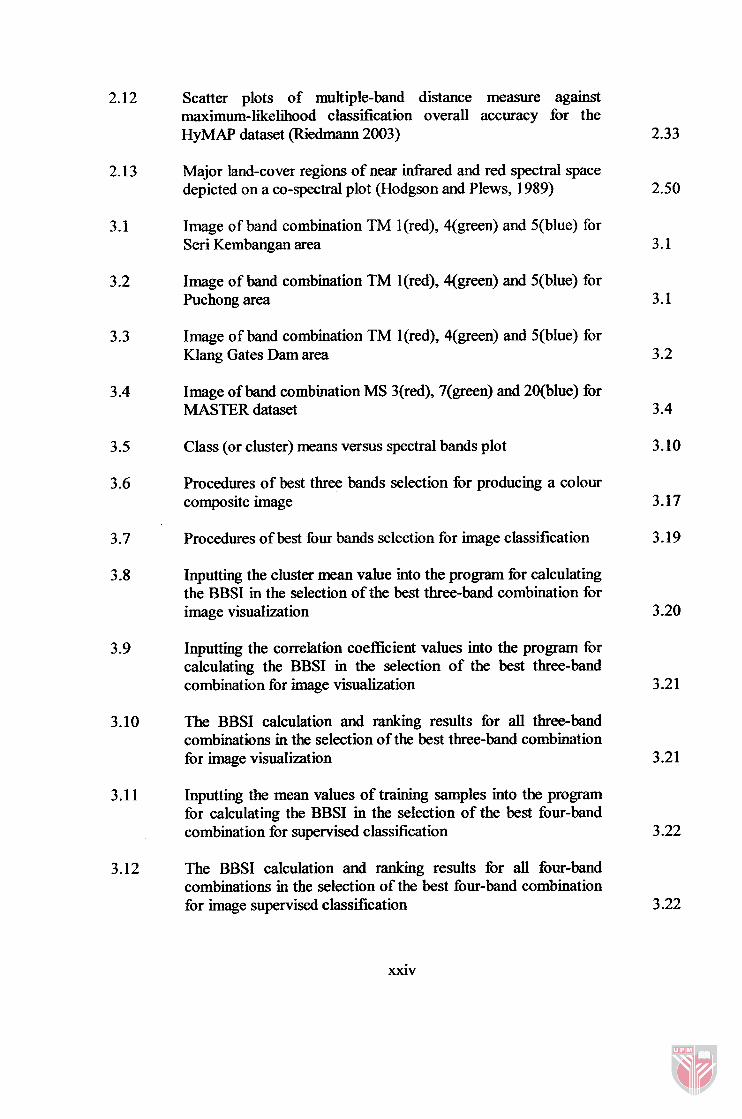
Scatter plots of multiple-band distance measure against maximum-likelihood classification overall accuracy for the HyMAP dataset (Riedmann 2003)
Major land-cover regions of near infrared and red spectral space depicted on a co-spectral plot (Hodgson and Plews, 1989)
Image of band combination TM l(red), 4(green) and 5(blue) for Seri Kembangan area
Image of band combination TM l(red), 4(green) and 5(blue) for Puchong area
Image of band combination TM ](red), 4(green) and 5(blue) for Klang Gates Dam area
Image of band combination MS 3(red), 7(green) and 20(blue) for MASTER dataset
Class (or cluster) means versus spectral bands plot
Procedures of best three bands selection for producing a colour composite image
Procedures of best four bands selection for image classification
Inputting the cluster mean value into the program for calculating the BBSI in the selection of the best three-band combination for image visualization
Inputting the correlation coefficient values into the program for calculating the BBSI in the selection of the best three-band combination for image visualization
The BBSI calculation and ranking results for all three-band combinations in the selection of the best three-band combination for image visualization
Inputting the mean values of training samples into the program for calculating the BBSI in the selection of the best four-band combination for supervised classification
The BBSI calculation and ranking results for all four-band combinations in the selection of the best four-band combination for image supervised classification