updated mineral resource estimate for personal use only · 12/8/2017 · received an updated...
TRANSCRIPT

ASX Announcement
8 December 2017
Alta Zinc Limited | ASX Code AZI | ABN 63 078 510 988 Level 2, 20 Kings Park Road, WA 6005, Australia
Email: [email protected] |Tel: +61 (0)8 9321 5000 | Fax: +61 (0)8 9321 7177 Website: www.altazinc.com
Page 1 of 30
Updated Mineral Resource Estimate
Supports Resource Growth Strategy
Alta Zinc Limited (ASX: AZI or “Alta Zinc”) (formerly Energia Minerals, ASX: EMX) has
received an updated Mineral Resource Estimate (Table 1) for the Colonna Zorzone
Deposit at its 100% owned Gorno Zinc Project (“Project”) in northern Italy from its
consultants, Jorvik Resources Pty Ltd.
Alta Zinc commissioned a mineral resource estimation revision to include all drilling results obtained to date. The revision was primarily focused on using the resource estimation to inform metallurgical and mining parameters for studies being completed on the Project, and to increase the level of geological knowledge and confidence in the mineral resource. The updated information underpins:
The revised project configuration study (refer to the 28 November 2017 ASX announcement titled “121 presentation”) that will be evaluated by potential financiers and off-takers; and
The 2018 resource growth strategy focusing primarily on the North (Piazzole) and East (Pian Bracca) extensions as described in the same presentation and outlined on page 3.
Updated Mineral Resource Estimate
December 2017 OK Estimate Reported using a 1% Zinc Cut-off Grade
Subdivided by JORC Code 2012 Resource Categories using ROUNDED figures
Category Tonnes (Mt)
Total Zinc Total Lead Silver
Grade
(%)
Metal (Kt)
Grade (%)
Metal (Kt)
Grade (ppm)
Metal (Moz)
Indicated 2.1 5.1 107 1.4 29 30.9 2.1
Inferred 1.2 4.6 56 1.1 14 20.9 0.8
Indicated + Inferred 3.3 4.9 163 1.3 43 27.2 2.9
Table 1: December 2017 Mineral Resource Estimate
The only material difference in data used in the new estimate compared to the previous May 2017 Mineral Resource Estimate was the inclusion of eight diamond drill hole results received subsequent to the information cut-off date for the prior estimation. After consultation with Alta Zinc’s mining and metallurgical consultants, during this revised estimate significant attention was given to the encapsulation of geological, metallurgical, and mining parameters within the geological wireframes, and estimation blockmodel. Particular attention was given to faulting, oxide/sulphide mineralisation distribution controls and locations, and the grade and dispersion of pyrite in the mineralisation.
For
per
sona
l use
onl
y

Page 2 of 30
The data generated has contributed extensively to the robustness of the mineralisation model, and the planning of future drilling, mining and processing techniques and other optimisation options. As a result of the revised estimation the following material changes have occurred:
The global zinc grade has risen slightly (0.1%), increasing the contained zinc metal by 3,000 tonnes;
Three mineralised zones within the resource have been modified to accommodate new drilling results;
Structural domaining of mineralised wireframes was completed to reflect more consistent local orientations of mineralisation, and
The largest mineralised wireframe (Domain 10) has been modelled using ordinary kriging rather than co-kriging (refer to Figure 2).
No material changes in the grade and contained metal of lead and silver or the estimation methodology has occurred. The new Mineral Resource Estimate outlines are shown in Figure 1.
Figure 1: Colonna Zorzone Deposit showing the revised Indicated and Inferred Resources
For
per
sona
l use
onl
y

Page 3 of 30
Figure 2: Zone 1 estimated with ordinary kriging
Next Steps
Alta Zinc aims to increase the level of geological knowledge and confidence in the Mineral Resource and will continue to focus on implementing low risk exploration strategies with the objective of expanding and improving the current Mineral Resource. Five mineralised areas have been identified adjacent to the existing Mineral Resource and plans are being developed to drill test these in 2018.
The commencement of these proposed drill programs will be subject to obtaining sufficient funding. The Company is currently investigating the most appropriate method to fund this exploration strategy.
Of these additional mineralised zones shown below in Figure 3 (North/Piazzole, East/Pian Bracca, Colonna Fontanone, Mt Arera and South/Riso Parina), the North (Piazzole) and East (Pian Bracca) extensions have been selected as the initial preferred options to expand the resource in 2018 given:
the historical geological information for these areas;
the results of recent underground mapping and sampling;
existing undergound access to be rehabilitated for drilling; and
the potential to improve the current Mineral Resource Estimate in the most cost-effective way.
For
per
sona
l use
onl
y

Page 4 of 30
Figure 3: Targeted Mineralisation Extensions and Regional Sampling Results to date
The work program for 2018 is outlined in Figure 4 below.
Figure 4: Work Program 2018
For
per
sona
l use
onl
y

Page 5 of 30
Alta Zinc will continue to focus on and develop opportunities identified in studies completed to date to enhance the potential project economics. This includes the outlined resource growth strategy. The Project’s robustness and attractiveness to potential investors, financiers and off-takers include:
Potential Mineral Resource growth available from known extensions of mineralisation;
Historic production of high quality Zn & Pb concentrates with very low levels of impurities;
Permits in place with strong support of the local authorities and communities; and
Location in Western Europe with access to developed infrastructure, utitilites, financiers, service providers and a skilled workforce as well as proximity to European zinc smelters.
In a tightening zinc market, Gorno remains one of the few brownfield zinc mine development options globally.
For and on behalf of Alta Zinc Limited.
Alexander Burns Executive Chairman/Chief Executive Officer +61 8 9321 5000 [email protected]
For media enquiries contact: Peter Klinger Cannings Purple +61 (0)411 251 540 [email protected]
Competent Person Statement
The information in this announcement that relates to the Sampling Techniques and Data and Reporting of
Exploration Results for the Gorno Zinc Project is based on, and fairly represents, information which has
been compiled by employees of Alta Zinc under the supervision and guidance of Mr David Andreazza, a
full time employee of Alta Zinc and Member of the Australasian Institute of Geoscientists. Mr Andreazza
has sufficient experience that is relevant to the style of mineralisation and type of deposit under
consideration and to the activity that is being undertaken to qualify as Competent Person as defined in the
2012 Edition of the ‘Australasian Code for Reporting of Exploration Results, Mineral Resources and Ore
Reserves’. Mr Andreazza consents to the inclusion in this report of the matters based on his information
in the form and context in which they appear.
The information in this announcement that relates to the Mineral Resource estimate at The Gorno Zinc
Project is based on, and fairly represents, information which has been compiled by Mr Stephen Godfrey.
Mr Godfrey is a Principal Geologist at Jorvik Resources Pty Ltd and a Member of the Australasian Institute
of Mining and Metallurgy. Mr Godfrey has sufficient experience that is relevant to the style of mineralisation
and type of deposit under consideration and to the activity that is being undertaken to qualify as Competent
Person as defined in the 2012 Edition of the ‘Australasian Code for Reporting of Exploration Results,
Mineral Resources and Ore Reserves. Mr Godfrey consents to the inclusion in this report of the matters
based on his information in the form and context in which they appear.
For
per
sona
l use
onl
y
Page 6 of 30
Summary of Resource Estimation
The Gorno Project is comprised of Alpine style Zinc-Lead-Silver mineralisation which is broadly stratabound, but with some discordant (breccia) mineralisation, largely hosted in the Metallifero Limestone, a dominantly limestone unit forming part of the Lombard Basin sedimentary sequence of the Southern Italian Alps. Locally the stratigraphy in the mine area forms undulating folds resulting in paired antiform and synform structures trending approximately east-west, and there is a significant fault structure (central fault) trending near N-S that bisects the deposit with clockwise rotational displacement. Various northeast and northwest trending fault structures are also interpreted based on mapping of the underground mine workings and structural data from the diamond drilling. Jorvik has reviewed and validated all of the supplied underground workings location data, geological and structural mapping, drilling, survey, assay, bulk density and QAQC data for the project available up until 16 June 2017. Sampling data reviewed and considered in the resource estimate is derived from diamond drilling completed by Alta Zinc in 2015-2017 and historical diamond and percussion pre-production drilling completed by SAMIM between 1973 and 1980. The deposit has been assessed based on detailed validation of irregularly spaced diamond drill hole intersections that pierce the mineralised zones on approximately a 50 mE by 50 mN grid and additional drilling of generally lower confidence with incomplete data (eg. no assay, and or no geology or stratigraphy logging data). Assay results for a total of 137 diamond drillholes drilled in the Project area have been used to directly inform the resource estimate while all of the remaining drilling data (geological, structural and grade) have been considered in the development of the geological interpretation. The location and geometry of the contact between the Metallifero Limestone and overlying Gorno Formation has been modelled by Jorvik based on mapping of the underground workings and geological logging of the diamond drill holes. A nominal cut-off grade of 1.0% zinc over at least 2 metres true thickness was used to model 3-D wireframe solids outlining the mineralised domains using the wireframe model of the Metalifero / Gorno contact to guide the geometry based on observations of the mineralisation continuity and minimum thickness of the mineralisation that could be potential be exploited using underground industry standard underground mining methods. The mineralised zone domains were further subdivided into structural domains isolating regions of locally more consistent mineralisation style (strata-form or breccia) and orientation. Regions of high and low oxidation within the mineralised zones were also modelled based on zinc oxide assays of samples from the Alta Zinc drilling and structural mapping data. Correlation and regression analysis between the bulk density and Zn+Pb assay data for 224 samples determined that increasing bulk density values are related to increasing lead and zinc grades. A second order polynomial regression was fitted to the Zn+Pb versus bulk density data for 167 samples captured within the modelled mineralised zones, and was used to calculate bulk density values for all samples informing the resource estimate. The average bulk density of the lower grade and waste samples in the bulk density dataset is 2.72 tm-3. The Zn, Pb, Ag, bulk density and Zn and Pb oxide ratio data for all core samples captured within mineralisation wireframes were composited over the entire drill intersection length within each mineralised zone wireframe weighted by both length and bulk density. An empty block model was constructed in the Vulcan® mining software package using a 25 m (E) by 25 m (N) by 25 m (RL) parent block size, minimum sub-celling to 0.5 m (E) by 0.5 m (N) by 0.5 m (RL) and domain coding based on the modelled mineralised zone (structural) domains and oxidation domains. The void space relating to wireframe models of the underground mine development was also calculated for each block. Multiple estimation techniques including ordinary kriging, inverse distance weighting and nearest neighbour methods were used to accommodate the significant variation in drilling density and number of intersections across the mineralised domains. All estimates were completed using an accumulation method which computes a weighted average grade over the length of the hole and corrects for true
For
per
sona
l use
onl
y

Page 7 of 30
thickness of the orebody and assigns the weighted grade to the true thickness. Grade was not directly estimated but was back-calculated from the estimation of the accumulation (m * grade) divided by the estimate of the true thickness (m). Strong spatial correlations between true thickness and specific gravity, Ag, Pb and Zn accumulations were observed and modelled in cross-variograms which were used for the ordinary kriging of specific gravity, Ag, Pb and Zn accumulation and true thickness to maintain consistency during back-calculations of the specific gravity values. The cross-variograms between true thickness and Ag, Pb, Zn and specific gravity were all fitted with the same model. IsatisTM software was used to estimate true thickness and accumulation for Zn, Pb, Ag and bulk density (BD) for domains 30, 40, 50 and 60. Vulcan software was used to estimate true thickness and accumulation for Zn, Pb, Ag and bulk density (BD) for domains 10, 20 and 70. Vulcan software was used to estimate true thickness and accumulation for Zn and Pb oxide ratios. Soft boundaries were used for estimation across the structural domains of each mineralised zone while hard boundaries were used for estimation of zinc and lead oxide ratios within the modelled oxide domains. Comparison of the data both visually and statistically indicates reasonable and acceptable correlation between the block grades and the input data on a global basis in all directions in the block model. However, increased smoothing effects are evident proximal to mineralised drill intersections orientated at low angles to the plane of the mineralisation. Such smoothing effects reduce the ability to identify regions of higher or lower grade over the total interpreted true thickness of the mineralisation along the path of these drill holes. The Mineral Resource estimate for the Gorno Zinc Project has been classified in accordance with the guidelines as set out in the “Australasian Code for Reporting of Exploration Results, Mineral Resources and Ore Reserves” (JORC, 2012 Edition) by the Competent Person for this estimate, Mr. Stephen Godfrey. The estimates based on mineralised drill intersections on an approximate 50 m x 50 m grid have been classified as Indicated Resources using wireframes based on digitised outlines considering availability of QAQC information, geological complexity, data quantity, and drillhole spacing informing the mineralisation interpretation within each mineralised domain. Domain regions demonstrating relatively greater local geological complexity and / or are represented by a small number of drill intersections have been classified with more emphasis on geological (and grade) uncertainty and the need for closer spaced drilling. All block model estimates within the mineralised domains not classified as Indicated Resources have been classified as Inferred Resources based on evidence of reasonable geological and grade continuity from the available mineralised drill hole intersections. The Mineral Resource estimate is based on the assumption that traditional underground mining methods will be applied and the use of high confidence final grade control methods, for example, close spaced fan drilling, face mapping and sampling and stope grab sampling will be utilised. In order to classify mineralisation as a Mineral Resource, the Competent Person must be satisfied that there is a reasonable likelihood of eventual economic exploitation of the mineral deposit and report against a set of modifying factors (JORC Code, 2012 Edition). Jorvik has endeavoured where appropriate to assess and consider the likely metals pricing, mining, metallurgical, environmental and other modifying factors affecting the reporting of the contained zinc, lead and silver resources for the Colonna Zorzone deposit and is satisfied that there is a reasonable expectation that some current and future economic exploitation of the base metal mineralisation in the Colona Zorzone deposit will be possible. F
or p
erso
nal u
se o
nly

Page 8 of 30
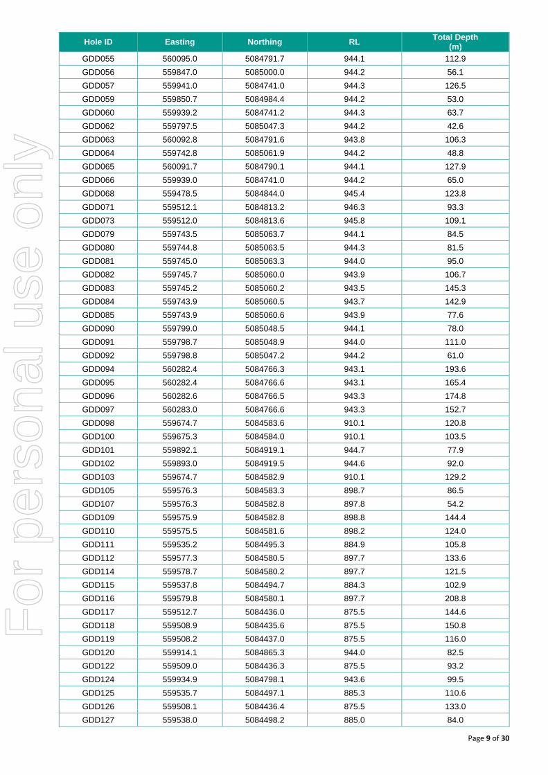
Table 2: Collar Coordinates for Drill holes used in the Resource Estimation
Hole ID Easting Northing RL Total Depth
(m)
FW34 559687.9 5084618.8 944.2 91.5
FW36 559688.5 5084563.5 944.3 99.4
FW38 559499.6 5084628.5 943.5 69.0
FW39 559497.7 5084628.2 945.0 78.0
FW40 559501.4 5084628.2 945.0 75.0
FW44 559689.8 5084561.2 944.3 142.0
FW55 559501.1 5084814.1 945.4 56.0
FW68 559707.7 5085075.4 943.9 59.5
GDD004 559950.4 5085007.6 1001.3 21.4
GDD005 559965.8 5085027.4 1001.3 27.5
GDD006 559918.1 5084960.6 1000.8 81.4
GDD007 559938.7 5084990.8 1000.4 56.4
GDD008 559803.2 5084742.2 943.2 24.7
GDD009 559945.9 5084998.6 1001.5 39.3
GDD010 559725.5 5084764.1 944.8 33.6
GDD011 559685.8 5084739.3 943.6 24.8
GDD015 559648.2 5084819.2 945.8 55.9
GDD016 559993.2 5085045.9 1001.4 32.5
GDD017 559908.8 5084945.6 999.7 23.0
GDD018 559650.0 5084820.3 945.5 82.4
GDD019 559908.8 5084945.7 1000.6 26.8
GDD022 559647.0 5084819.0 945.4 114.3
GDD024 560150.0 5084908.7 998.7 58.7
GDD025 559698.6 5084747.8 945.1 25.5
GDD026 559651.5 5084722.7 943.9 42.8
GDD027 559770.1 5084758.0 944.4 64.2
GDD028 559769.6 5084757.6 944.8 45.2
GDD029 559769.2 5084758.5 944.3 106.4
GDD030 559768.2 5084758.9 944.3 109.1
GDD031 559768.3 5084759.1 944.0 149.5
GDD032 559768.6 5084759.0 944.0 162.1
GDD035 559769.3 5084758.7 943.9 190.0
GDD037 559692.6 5084675.9 943.0 107.3
GDD039 559695.0 5084675.5 942.3 79.6
GDD041 559688.0 5084618.6 943.2 138.6
GDD042 559939.5 5084741.4 944.2 90.7
GDD043 559688.3 5084563.8 943.0 141.5
GDD044 559647.4 5084820.2 945.4 151.5
GDD045 559689.2 5084563.6 942.8 141.8
GDD047 560095.3 5084792.4 942.9 174.8
GDD048 559920.8 5084850.4 944.1 88.5
GDD049 559648.5 5084787.3 944.8 182.1
GDD050 560095.0 5084792.6 942.9 159.6
GDD051 560093.6 5084792.3 943.2 113.9
GDD052 559892.4 5084921.5 944.1 76.8
GDD053 560094.9 5084791.7 944.1 95.5
GDD054 559941.3 5084741.3 944.1 135.0
For
per
sona
l use
onl
y
Page 9 of 30
Hole ID Easting Northing RL Total Depth
(m)
GDD055 560095.0 5084791.7 944.1 112.9
GDD056 559847.0 5085000.0 944.2 56.1
GDD057 559941.0 5084741.0 944.3 126.5
GDD059 559850.7 5084984.4 944.2 53.0
GDD060 559939.2 5084741.2 944.3 63.7
GDD062 559797.5 5085047.3 944.2 42.6
GDD063 560092.8 5084791.6 943.8 106.3
GDD064 559742.8 5085061.9 944.2 48.8
GDD065 560091.7 5084790.1 944.1 127.9
GDD066 559939.0 5084741.0 944.2 65.0
GDD068 559478.5 5084844.0 945.4 123.8
GDD071 559512.1 5084813.2 946.3 93.3
GDD073 559512.0 5084813.6 945.8 109.1
GDD079 559743.5 5085063.7 944.1 84.5
GDD080 559744.8 5085063.5 944.3 81.5
GDD081 559745.0 5085063.3 944.0 95.0
GDD082 559745.7 5085060.0 943.9 106.7
GDD083 559745.2 5085060.2 943.5 145.3
GDD084 559743.9 5085060.5 943.7 142.9
GDD085 559743.9 5085060.6 943.9 77.6
GDD090 559799.0 5085048.5 944.1 78.0
GDD091 559798.7 5085048.9 944.0 111.0
GDD092 559798.8 5085047.2 944.2 61.0
GDD094 560282.4 5084766.3 943.1 193.6
GDD095 560282.4 5084766.6 943.1 165.4
GDD096 560282.6 5084766.5 943.3 174.8
GDD097 560283.0 5084766.6 943.3 152.7
GDD098 559674.7 5084583.6 910.1 120.8
GDD100 559675.3 5084584.0 910.1 103.5
GDD101 559892.1 5084919.1 944.7 77.9
GDD102 559893.0 5084919.5 944.6 92.0
GDD103 559674.7 5084582.9 910.1 129.2
GDD105 559576.3 5084583.3 898.7 86.5
GDD107 559576.3 5084582.8 897.8 54.2
GDD109 559575.9 5084582.8 898.8 144.4
GDD110 559575.5 5084581.6 898.2 124.0
GDD111 559535.2 5084495.3 884.9 105.8
GDD112 559577.3 5084580.5 897.7 133.6
GDD114 559578.7 5084580.2 897.7 121.5
GDD115 559537.8 5084494.7 884.3 102.9
GDD116 559579.8 5084580.1 897.7 208.8
GDD117 559512.7 5084436.0 875.5 144.6
GDD118 559508.9 5084435.6 875.5 150.8
GDD119 559508.2 5084437.0 875.5 116.0
GDD120 559914.1 5084865.3 944.0 82.5
GDD122 559509.0 5084436.3 875.5 93.2
GDD124 559934.9 5084798.1 943.6 99.5
GDD125 559535.7 5084497.1 885.3 110.6
GDD126 559508.1 5084436.4 875.5 133.0
GDD127 559538.0 5084498.2 885.0 84.0
For
per
sona
l use
onl
y

Page 10 of 30
Hole ID Easting Northing RL Total Depth
(m)
GDD128 559507.6 5084814.1 945.3 32.6
GDD130 559534.5 5084750.4 943.9 103.7
GDD131 559489.8 5084382.8 867.8 136.4
GDD132 559480.2 5084364.2 865.8 156.0
GDD133 559530.2 5084751.9 944.0 57.9
GDD134 559534.6 5084750.6 944.5 123.1
GDD135 559478.6 5084365.9 865.6 137.1
GDD136 559488.6 5084383.3 867.8 120.9
GDD137 559479.9 5084364.4 866.2 259.6
GDD139 559489.0 5084383.8 867.8 94.8
GDD143 559501.4 5084629.0 943.6 73.7
GDD144 559488.6 5084382.0 868.4 206.5
GDD145 559497.5 5084357.4 865.5 318.0
GDD146 559500.7 5084664.1 943.8 59.8
GDD147 559488.1 5084382.3 868.4 221.8
GDD148A 559496.6 5084357.0 865.5 295.5
PW04 559985.0 5085083.0 1021.0 186.5
PW05 559985.0 5085083.0 1021.0 117.0
PW06 559985.0 5085083.0 1021.0 125.0
PW08 559985.0 5085083.0 1021.0 154.0
PW26 559940.5 5085046.4 1000.4 106.3
PW31 560040.6 5084950.1 999.7 162.6
PW32 559821.7 5085075.5 1000.1 194.3
PW50 560147.8 5084909.2 999.4 234.0
PW51 560147.1 5084910.2 999.4 228.3
PW52 560149.8 5084909.0 999.3 190.6
PW53 559821.7 5085075.5 1000.1 184.2
PW62 559522.5 5084909.0 1001.1 109.5
RP25 559570.1 5084177.2 609.3 81.7
RP26 559571.1 5084177.2 609.3 120.0
RP29 559572.0 5084177.2 609.3 80.0
RP34 559431.4 5084085.2 609.9 56.5
RP36 559431.4 5084085.2 609.9 79.5
RP37 559367.2 5084037.7 610.2 52.5
RP38 559367.2 5084037.7 610.2 58.0
RP45 559319.4 5084002.6 610.4 21.5
RP46 559319.4 5084002.6 610.4 42.0
GDD151 559496.0 5084357.0 865.5 214.1
GDD155 559872.2 5084718.0 944.1 83.3
GDD156 559954.0 5084734.0 944.9 69.5
For
per
sona
l use
onl
y

Page 11 of 30
Section 1 Sampling Techniques and Data (Criteria in this section apply to all succeeding sections).
Criteria JORC Code Explanation Commentary Competent Person
Sampling techniques
Nature and quality of sampling (eg cut channels, random chips, or specific specialised industry standard measurement tools appropriate to the minerals under investigation, such as down hole gamma sondes, or handheld XRF instruments, etc). These examples should not be taken as limiting the broad meaning of sampling.
Sampling data considered in the resource estimate was derived from diamond drilling completed by Alta Zinc in 2015-2017 and historical diamond and percussion pre-production drilling completed by SAMIM between 1973 and 1980.
NQ and T2-66 size core (47.6 and 51.7mm respectively) collected from the Alta Zinc drilling were half core cut using a diamond saw with half the core being dispatched to the laboratory, and half retained. Individual samples were taken on geological intervals with lengths ranging between 0.7m and 1.3m. Sampling for assay typically extended approximately 2m up and down hole from the logged mineralised drill intersections.
The sampling methodology applied to AQ size (27mm) core collected from the historical diamond drilling is unknown, however, the historical database indicates that most of the sampling was completed over 1m intervals.
Sample return from the historical percussion drilling was via mud/sludge. The sample collection methodology is unknown however, based on historical records most samples were collected over a rod length of 1.2m.
David Andreazza
Include reference to measures taken to ensure sample representivity and the appropriate calibration of any measurement tools or systems used.
The core collected by Alta Zinc is mostly very competent requiring little deviation from routine core run lengths of approx. 1.5m. The core also cuts well with little material loss or contamination and is cut perpendicular to the prevailing structure (mostly bedding) observed in the core.
Measures taken to ensure sample representivity from the historical diamond and percussion drilling are unknown, but twinning of three historical SAMIM drill holes by Alta Zinc indicates that the historical sampling adequately isolated mineralised intervals of core with resultant grades similar to those based on the Alta Zinc samples, accounting for local variability of grades.
David Andreazza
Aspects of the determination of mineralisation that are Material to the Public Report.
In cases where ‘industry standard’ work has been done this would be relatively simple (eg ‘reverse circulation drilling was used to obtain 1m samples from which 3kg was pulverised to produce a 30g charge for fire assay’). In other cases more explanation may be required, such as where there is coarse gold that has inherent sampling problems. Unusual commodities or mineralisation types (eg submarine nodules) may warrant disclosure of detailed information.
Cut core samples from the Alta Zinc drilling were dispatched using a reputable contract courier from site to the laboratory where half core is dried, then crushed and pulverised to allow 85% to pass -75µm (industry standard).
Alta Zinc inserted duplicates, blanks and certified reference materials into sample series collectively at a rate of approximately 3 in 20. In addition, laboratory pulps from 3 sample batches were submitted for umpire analysis.
Mineralisation is contained in oxide and sulphide material but is predominantly sulphide. Studies and recent observations have shown low levels of deleterious elements in both material types.
Alta Zinc has comprehensive procedures and protocols in place to ensure that ‘Industry Standard’ sampling processes are employed as a minimum.
Historical records indicate that samples from the SAMIM diamond and percussion drilling were processed at an ‘in-house’ laboratory however, little information on the laboratory or sample processing methodology(s) are available.
David Andreazza
For
per
sona
l use
onl
y

Page 12 of 30
Criteria JORC Code Explanation Commentary Competent Person
Drilling techniques
Drill type (eg core, reverse circulation, open-hole hammer, rotary air blast, auger, Bangka, sonic, etc) and details (eg core diameter, triple or standard tube, depth of diamond tails, face-sampling bit or other type, whether core is oriented and if so, by what method, etc).
The Diamec rigs have collected T2-66 size core and the Sandvivk rig, NQ size core (approx. same diameter of 47.6 and 51.7mm respectively). Oriented core has been collected for approximately 53% of the Alta Zinc drill holes whilst Televiewer downhole surveys (enabling determination of intersected structure orientations) have been completed for an additional 27% of the Alta Zinc drill holes.
Historical (SAMIM) diamond drilling was completed using unknown drill rig types collecting non-oriented AQ size core (27mm).
Historical (SAMIM) percussion drilling was completed using unknown rig types.
David Andreazza
Drill sample recovery
Method of recording and assessing core and chip sample recoveries and results assessed.
Core recovery has been logged for all of the Alta Zinc drilling, averaging 98% in both waste and mineralised material. Core blocks are inserted by the drillers at the end of each drilling run, noting the run length, and downhole depth. This data is then compared to the measured recovered core length and recoveries for each run and the entire hole are calculated. Given the nature of the drilling, and the type of mineralisation encountered to date the sampling is judged as being representative.
Core recoveries from the historical diamond drilling are not detailed in reports.
David Andreazza
Measures taken to maximise sample recovery and ensure representative nature of the samples.
The core collected by Alta Zinc is largely very competent with routine core run lengths of approximately 1.5m. Run lengths were reduced accordingly in fractured or broken ground.
Measures taken to maximize sample recovery from the historical diamond and percussion drilling are unknown.
David Andreazza
Whether a relationship exists between sample recovery and grade and whether sample bias may have occurred due to preferential loss/gain of fine/coarse material.
There is no evidence of bias due to preferential loss/gain of fine/coarse material from the Alta Zinc drill core. Core recovery averages 98% in both waste and mineralised rock.
No assessment of possible relationships between sample recovery and grade in the historical drilling are possible due to a lack of recovery data.
David Andreazza
Logging
Whether core and chip samples have been geologically and geotechnically logged to a level of detail to support appropriate Mineral Resource estimation, mining studies and metallurgical studies.
All Alta Zinc drill holes have been geologically logged on geological intervals recording lithology, grain size and distribution, sorting, roundness, alteration, mineralisation, veining, structure, oxidation state, colour and geotechnical data noted and stored in the database. All holes were logged to a level of detail sufficient to support future mineral resource estimation, scoping studies, and metallurgical investigations.
All historical diamond drill holes were geologically logged on geological intervals. Information pertaining to colour, grainsize, lithology and alteration were manually logged on paper. The level of detail logged is sufficient to support Mineral Resource estimation.
Historical percussion holes were NOT geologically logged. Holes were drilled to ascertain extent of and grade of the surrounding mineralisation intersected in exploration drives.
David Andreazza
Whether logging is qualitative or quantitative in nature. Core (or costean, channel, etc) photography.
Alta Zinc Drilling: Oxidation, colour, alteration, roundness, sorting, sphericity, alteration and mineralisation are logged qualitatively. All other values are logged quantitatively. All holes have been photographed both wet and dry and are stored in a database.
Historical diamond drilling: All of the logging was qualitative (subjective opinion) in nature. No known core photographs exist.
David Andreazza
The total length and percentage of the relevant intersections logged.
All Alta Zinc holes have been logged over their entire length (100%) including any mineralised intersections. To date the average core loss is less than 2%.
David Andreazza
For
per
sona
l use
onl
y

Page 13 of 30
Criteria JORC Code Explanation Commentary Competent Person
Logging (Cont’d)
All historical diamond holes were logged over their entire length, except where recovery was zero (which was rare, and noted in the logs as no recovery).
Sub-sampling techniques and sample preparation
If core, whether cut or sawn and whether quarter, half or all core taken.
All Alta Zinc core is half cut using a Diamonte table diamond saw, typically producing samples for lab submission of approximately 2.5kg weight.
Core cutting records from historical drilling are not available.
David Andreazza
If non-core, whether riffled, tube sampled, rotary split, etc and whether sampled wet or dry.
The sample sub sampling technique(s) applied to the wet rock chip samples from the historical percussion drilling is unknown. No non-core drilling techniques have been employed by Alta Zinc.
David Andreazza
For all sample types, the nature, quality and appropriateness of the sample preparation technique.
Alta Zinc Drilling: Mineralised core is visually identified, and then sampled in geological intervals using 0.7-1.3m intervals, the core is then half cut and half the core is wholly sampled for that interval then inserted into pre numbered calico bags. Cut core samples were dispatched from site to the laboratory where half core is dried, then crushed to -2mm and pulverised to allow 85% to pass -75µm. The sample preparation technique is deemed appropriate.
Sample preparation techniques for the historical diamond and percussion drilling is unknown
David Andreazza
Quality control procedures adopted for all sub-sampling stages to maximise representivity of samples.
Alta Zinc quality control procedures include following standard procedures when sampling, including sampling on geological intervals, and reviews of sampling techniques in the field. Alta Zinc core was typically cut at the maximum angle to the prevailing penetrative structure in the core.
The laboratory procedures applied to the Alta Zinc sample preparation included the use of cleaning lab equip. w/ compressed air between samples, quartz flushes between high grade samples, insertion of crusher duplicate QAQC samples, periodic pulverised sample particle size (QAQC) testing and insertion of laboratory pulp duplicates QAQC samples.
Quality control procedures employed for sub-sampling of the historical drilling are not documented in reports.
David Andreazza
Measures taken to ensure that the sampling is representative of the in situ material collected, including for instance results for field duplicate/second-half sampling.
Alta Zinc field QC procedures included the collection of field duplicates at a rate of 1 in 20 and consist of ¼ core taken from the reserved ½ core.
Measures taken to ensure representative nature of samples from the historical diamond and percussion drilling are not detailed in reports.
David Andreazza
Whether sample sizes are appropriate to the grain size of the material being sampled.
Alta Zinc Drilling: The expected sample weight for 1m of half core T2-66 is approximately 2.7kg, and NQ is 2.4kg. This sample weight should be sufficient to appropriately describe base metal mineralisation grades from mineral particle sizes up to 5mm. Historical Drilling: It is not known whether sample sizes appropriate to the grain size were collected from the historical drilling.
David Andreazza
Quality of assay data and laboratory tests
The nature, quality and appropriateness of the assaying and laboratory procedures used and whether the technique is considered partial or total.
Alta Zinc Drilling: The primary laboratory has used a four acid digestion process that is able to dissolve most minerals; however, although the term “near-total” is used, depending on the sample matrix, all elements may not be quantitatively extracted. The analysis techniques employed are ICP-AES (Atomic Emission Spectroscopy), with ICP-AAS (Atomic Absorption Spectroscopy typically used to quantify higher grade base metal mineralisation. All laboratory sample pulps reporting initial total Zn grades of 1% or more
David Andreazza
For
per
sona
l use
onl
y

Page 14 of 30
Criteria JORC Code Explanation Commentary Competent Person
Quality of assay data and laboratory tests (Cont’d)
were also analysed for Zn oxide by ICP-AAS. Similar analysis for Pb oxide were completed on 30% of the samples with initial Zn total assays of 1% or more.
The digestion methods and analysis techniques used for the Alta Zinc samples are deemed appropriate for the nature of the mineralisation.
The nature, quality, and appropriateness of assaying technique(s) applied to the historical samples are unknown.
For geophysical tools, spectrometers, handheld XRF instruments, etc, the parameters used in determining the analysis including instrument make and model, reading times, calibrations factors applied and their derivation, etc.
Hand held XRF equipment has been used to determine preliminary Zn and Pb concentrations in Alta Zinc core. The data was used only as a guide to selecting intervals of oxidised mineralisation for full assay analysis. None of the XRF data were used as input to resource estimation.
No geophysical or other tools were used to assess grade concentrations in samples from the historical drilling.
David Andreazza
Nature of quality control procedures adopted (eg standards, blanks, duplicates, external laboratory checks) and whether acceptable levels of accuracy (ie lack of bias) and precision have been established.
Alta Zinc inserts QA/QC samples (duplicates, blanks and standards) into the sample series at a rate of approx. 3 in 20. These are tracked and reported on by Alta Zinc for each batch. When issues are noted the laboratory is informed and investigation conducted defining the nature of the discrepancy and whether further check assays are required. The laboratory completes its own QA/QC procedures and these are also tracked and reported on by Alta Zinc. Acceptable overall levels of analytical precision and accuracy are evident from analyses of the routine QAQC data.
Alta Zinc has submitted pulps from 3 original laboratory batches; 446 samples, including a total of 72 Alta Zinc and primary lab QAQC samples, for umpire analysis at a second lab using similar analytical processes as the primary lab,. The results indicate the primary lab may marginally under-report Zn and Pb (insignificant) but significantly under-report Ag by nearly 11% (relative). The difference is attributed to a more complete sample digestion method used by the umpire lap (mircrowave under pressure vs simple heating used by the primary lab).
Quality control procedures applied to the analysis of historical samples are unknown.
David Andreazza
Verification of sampling and assaying
The verification of significant intersections by either independent or alternative company personnel.
Significant mineralised intersections from the Alta Zinc drilling have been routinely checked by Alta Zinc Minerals personnel, and independent consultants in January 2016, June 2015, June 2012, and March 2010. Visual estimates of sphalerite content are typically confirmed with assay data.
Data for significant mineralised drill intersections from the historical drilling have been checked by Alta Zinc Minerals personnel and consultants in January 2016, June 2012 and March 2010. This data is generally supported in 3-D by near-by drill intersections from the Alta Zinc drilling.
David Andreazza
The use of twinned holes. Alta Zinc has twinned three historical diamond drill hole and effectively seven historical percussion drill holes with five diamond drill holes. There is good correlation of intersection lengths and grades in the twin diamond drill hole pair, however, twinning of additional historical diamond drill holes is recommended in order to establish a more robust comparative dataset. Assay data for historical diamond drilling is considered suitable for use in resource grade estimation but is of reduced confidence compared to the Alta Zinc data.
While there is high variability, no obvious bias exists between the mineralised intersection
David Andreazza For
per
sona
l use
onl
y

Page 15 of 30
Criteria JORC Code Explanation Commentary Competent Person
Verification of sampling and assaying
(Cont’d)
lengths and grades reported for the Alta Zinc holes that twin the historical percussion holes. This is not considered to endorse the use of the percussion drill hole assay data for resource grade estimation but does support its use as a guide for interpretation 3-D mineralisation constraints for resource estimation.
No historical twin holes are known to have be drilled.
Documentation of primary data, data entry procedures, data verification, data storage (physical and electronic) protocols.
All Alta Zinc geological, sampling, and spatial data generated and captured in the field is immediately entered into a field notebook on standard Excel templates. These templates are then validated each night in Micromine. This information is then sent to Alta Zinc’s in house database manager for further validation. If corrections need to be made they are corrected the following day by the person responsible for generating the data. Once complete and validated the data is then compiled into a SQL database managed by an external consultant.
All historical drilling data has been compiled from hand written reports and entered into Excel templates. The resultant data have been validated in Micromine and forwarded to Alta Zinc’s in house database manager for further validation. If corrections were required, edits were completed by the person responsible for capturing the data. Once complete, the validated the data has been compiled into a SQL database.
David Andreazza
Discuss any adjustment to assay data. No adjustments or calibrations have been made to any assay data. David Andreazza
Location of data points
Accuracy and quality of surveys used to locate drillholes (collar and down-hole surveys), trenches, mine workings and other locations used in Mineral Resource estimation.
The location and 3-D configuration of accessible underground workings on the 940m and 990m levels and all drill hole collars from the Alta Zinc drilling have been surveyed by licensed contractors using RTK GPS equipment to locate the mine access portal (Forcella), robotic total station instrumentation for underground survey control and drill hole collar pick-ups, and laser scanning equipment to determine underground tunnel topology. The accuracy of the survey points is within 0.5m in northing, Easting and RL.
All underground mine workings and historical drill hole collars within the Gorno mine area have been digitised from multiple historical plans and geo-referenced according UG workings common across the plans. Underground geological mapping and locations of structural measurements have also been captured using the same process.
The locations of unsurveyed UG workings on the 600m, 1000m, 1040m and 1080m levels, the historical drill hole collars on these levels, UG mapping and structural data within the resource area have been further adjusted with geo-referencing of the historical plans relative to the newly surveyed UG workings. The location accuracy of these non-surveyed location data is estimated at +25m with improved accuracy of approx. +10m expected for the location and UG workings, drill hole collars and mapping on the 600m level using location control based on a vent bore between the 940m and 600m levels.
Downhole orientation surveying of Alta Zinc holes has been conducted using a Reflex multishot EZ TRAC instrument recording measurements at 1, 2 or 4 metre intervals or a digital televiewer instrument at irregular close spaced (<1m) intervals.
Orientations of the historical diamond and percussion drill holes have been determined from paper plans and drill hole logs.
Downhole surveys of the Alta Zinc drill holes show no significant down hole deviations. It is therefore assumed that the orientations of the historical diamond drill holes are adequately defined based on the logged collar orientation data.
David Andreazza
For
per
sona
l use
onl
y

Page 16 of 30
Criteria JORC Code Explanation Commentary Competent Person
Location of data points (Cont’d)
The logged orientation of the historical percussion drill holes appears to be ‘generic’ at fixed azimuth and inclinations perpendicular to the UG development.
While no survey verification of the historical drill hole collars locations or collar orientations has been undertaken, there is generally good correlation in the spatial location of mineralised drill intersections between the historical and Alta Zinc drill holes.
Specification of the grid system used. The grid system used at Gorno is WGS_1984_UTM_Zone_32N. Easting and Northing are stated in metres.
David Andreazza
Quality and adequacy of topographic control. Surface topography data was supplied by the Regione Lombardia (regional government) and is of sufficient accuracy to confirm the location of the Forcella access tunnel.
David Andreazza
Data spacing and distribution
Data spacing for reporting of Exploration Results. Drill hole orientation and spacing is non-uniform with multiple holes often drilled from drill set-up locations along exploration drives. An irregular grid of approximately 50mE by 50mN spaced diamond drill hole intersections through the mineralisation exists between the 850m and 1020m RLs, dominated by Alta Zinc drilling. Some closer spaced diamond drilling (approx. 25m x 50m) tests mineralisation between the 990m and 1020m RLs while elsewhere, the diamond drill hole spacing is generally broader except a cluster of historical holes drilled from UG workings on the 600m RL.
The percussion drilling is distributed in clusters of horizontal and 47° inclined (up) holes at 5m or 10m intervals along selected exploration drives or in horizontal radial fans collared at single rig set-up locations. Assays for these holes were used as guide to interpreting local mineralisation extents.
David Andreazza
Whether the data spacing and distribution is sufficient to establish the degree of geological and grade continuity appropriate for the Mineral Resource and Ore Reserve estimation procedure(s) and classifications applied.
The data spacing and distribution is considered sufficient to establish an appropriate degree of geological and grade continuity appropriate for classification of Indicated and Inferred Mineral Resources.
David Andreazza
Whether sample compositing has been applied. Sample compositing has been done only for a minority of the historical diamond drill holes, with no justification given in the geological logs.
David Andreazza
Orientation of data in relation to geological structure
Whether the orientation of sampling achieves unbiased sampling of possible structures and the extent to which this is known, considering the deposit type.
The attitude of the Metallifero Limestone (host of mineralisation) is interpreted have an
average dip to the south of 30⁰ towards an azimuth of 189⁰ with dip angles ranging from sub horizontal (5-10 degrees) to moderately dipping (up to 30-45 degrees). Bedding attitude has been interpreted from drill hole intersections and dip and dip direction data obtained in the exploration drives and downhole televiewer results. The level of confidence in the bedding and much of the mineralisation attitude is relatively high, despite the multiple directions of drilling from the drives some intersections are at very low angles to the bedding attitude and mineralisation. Measured true thicknesses of the mineralisation at the diamond drill hole intersections are on average 65% less than the drill intersection lengths, while 30% of the true thickness measurements are 82% less than the corresponding drill intersection lengths. There is no evidence of bias in full mineralised intersection grades or true thicknesses in the corresponding diamond drill holes oriented at low angles to the attitude of the mineralisation.
Much of the historical percussion drilling has been drilled horizontal at a very low angle to the dip of the mineralisation. This compounded with likely downhole contamination of samples due to settling of heavy minerals on the lower curvature of the holes has been
David Andreazza
For
per
sona
l use
onl
y

Page 17 of 30
Criteria JORC Code Explanation Commentary Competent Person
Orientation of data in relation to geological structure (Cont’d)
considered in the interpretation of mineralisation constraints for resource estimation.
If the relationship between the drilling orientation and the orientation of key mineralised structures is considered to have introduced a sampling bias, this should be assessed and reported if material.
An accumulation resource grade estimation approach has been used which weights a single composite of the drill hole assay over the full mineralised drill intersection by the interpreted true thickness of the mineralisation at the drill intersection (centre point). This effectively negates the effects of variations in the drill hole sample support (and potential bias) relating to drill holes that intersect a mineralised horizon at highly variable orientations. However, compositing of the mineralised zone intersections for the drill holes intersecting the mineralisation at low angles produces composites reflecting unavoidable increased smoothing of local grades and therefore, less estimation selectivity proximal to such drill intersections.
Stephen Godfrey
Sample security
The measures taken to ensure sample security. Samples from the Alta Zinc drilling are dispatched from the Exploration Site using a single reputable contracted courier service to deliver samples directly to the analytical laboratory where further sample preparation and analysis occurs.
Measures taken to ensure sample security from the historical drilling are unknown.
David Andreazza
Audits or reviews
The results of any audits or reviews of sampling techniques and data.
Alta Zinc conducts regularly reviews of sampling techniques and material sampled to ensure any change in geological conditions is adequately accounted for in sample preparation. Reviews of assay results and QA/QC results occur for each batch. 1 in 10 checks on all compiled and entered data are completed by Alta Zinc.
Jorvik Resources was retained to undertake a site visit and review of the drilling and sampling techniques, and data in January 2016. Jorvik considers the sampling procedures used by Alta Zinc and resulting data to be appropriate, aligned with industry standard methodologies, and suitable for use in resource modelling. However, Jorvik considers the use of drill holes orientated at shallow angles to mineralisation to hinder more effective geostatistical analysis of the data and to adversely affect the geostatistical consistency of the resulting block model estimates.
David Andreazza
Stephen Godfrey
Section 2 Reporting of Exploration Results (Criteria listed in the preceding section also apply to this section).
Criteria JORC Code Explanation Commentary Competent Person
Mineral tenement and land tenure status
Type, reference name/number, location and ownership including agreements or material issues with third parties such as joint ventures, partnerships, overriding royalties, native title interests, historical sites, wilderness or national park and environmental settings.
The Gorno Lead Zinc deposit is located in the north of Italy, in the Lombardia Province. The Gorno Project is made up of eleven (11) granted tenements: Decrees 845, 1995, 2869, 2872, 3365, 3366, 3910, 3917, 3920, 3921, 5846; and six applications. These leases are 100% owned and operated by Energia Italia, a 100% owned subsidiary of Alta Zinc. The titles are current at the time of release of this report.
David Andreazza
The security of the tenure held at the time of reporting along with any known impediments to obtaining a licence to operate in the area.
All tenements are in good standing and no impediments to operating are currently known to exist.
David Andreazza
Exploration done by other parties
Acknowledgment and appraisal of exploration by other parties.
A significant amount of work was undertaken by ENI subsidiaries in the region. Drilling works completed in the period between 1964 and 1980 have been compiled and digitised. The work completed at the Gorno deposit has included the development of more than
David Andreazza
For
per
sona
l use
onl
y

Page 18 of 30
Criteria JORC Code Explanation Commentary Competent Person
230km of exploration drives, detailed mapping, and the mining and production of high grade zinc concentrate. Large scale mining operations ceased at the Gorno deposit in 1978, and the project closed in 1980.
Geology
Deposit type, geological setting and style of mineralisation.
The Gorno deposit is an Alpine Type Lead-Zinc deposit (similar to Mississppi Valley Type Lead Zinc deposits) and broadly stratabound with some breccia bodies and veining also occurring. It displays generally simple mineralogy of low iron sphalerite, galena, pyrite, with significant quantities of silver. Gorno lies in a part of the Italian Southern Alps named “Lombard Basin”, formed by a strong subsidence occurring in the Permian-Triassic which allowed the subsequent accumulation of a thick sedimentary pile. The sedimentary sequence is constrained laterally by the Luganese Platform to the west and by the Atesina Platform to the east. The lithotypes in the southern portion of the basin are predominantly Triassic in age. The geological sequences of importance in relation to mineralisation, from oldest to youngest are as follows:
Breno Formation: a back-reef limestone composed by light grey calcareous beds, 10 to 170 m thick. The facies indicate a palaeogeographical evolution from back reef to shelf environment, in low energy water to alternating peri-tidal cycles.
Metallifero Limestone: composed of dark grey to black limestone deposited in stromatolitic tidal flats, with siliceous intercalations present in the upper part. The dark colour suggests a stagnant anaerobic depositional environment with bituminous beds generally present at the footwall of the Metallifero. This formation represents a transitional phase between the underlying shelf environment and the upper sequence typified by a peri-continental and detrital sedimentation. Three tuffaceous levels are present in the Metallifero stratigraphical column. The pyroclastic tuffs are submarine volcanic phases which intervened during the deposition of the limestones, and effectively represent a control for the mineralized horizons, in that they are always found at the foot wall (Tuff 1) and at the hanging wall (Tuff 2) of the productive mineralised horizons.
Gorno Formation: alternating thinly bedded, black limestone and laminated marl deposited in protected lagoon environment with a thickness of 0-350 metres. A thin tongue, intercalated between the Metalliferous Limestone and the Val Sabbia Sandstone, is often mineralised and is referred to as the mineralised “black shales” of the Gorno deposits.
Val Sabbia Sandstone: present along the southern Lombard Basin border and is composed of alternating tuffaceous sandstone and green and\or red silt-mudstone. These were possibly derived from the erosion of continental sediments present to the south. The thickness varies between 0 and 400 metres.
San Giovanni Bianco Formation: is composed of a thick alternation of marl, sandstone, siltstone and mudstone which transitions at the top of the unit to cellular limestone and evaporitic vuggy dolomite, estimated thickness to be in the order of 150 metres.
Structure in the basin is typified by E-W trending belts which can be subdivided in five sectors:
Orobic Anticline, in the northern part, which includes Palaeozoic successions;
Valtorta-Valcanale Line, oriented E-W and separating the Orobic Anticline to the north from the Pb-Zn mineralised belt in the south. The line is responsible for
David Andreazza
For
per
sona
l use
onl
y

Page 19 of 30
Criteria JORC Code Explanation Commentary Competent Person
Geology
(Cont’d)
many of the allochthonous units;
Camuno Autochthonous, including the sedimentary cover, which is covered in the central-western part by various overthrusts and outcrops only in the east;
Para-autochthonous and allochthonous units, present over a large area to the south of the Valtorta-Valcanale Line and formed by the double or triple superimposition of the Triassic carbonate formations;
Fold and fold-fault zone, which constitutes the southern sector near the Po plains and includes Jurassic-Cretaceous formations.
Mineralisation in the Gorno district occurs within the Camuno Autochthonous Zone, and the para-autochthonous, and allocthounous units. The geometry of the mineralised bodies is mainly stratabound with common characteristics in the majority of the Gorno deposits. The prevailing distribution trend is N-S and the shape, represented by tabular “columns”, which can be longitudinally developed for more than 2000 metres, with widths from 50 to 100 metres and thickness between 3 and 20 metres.
Drillhole Information
A summary of all information material to the understanding of the exploration results including a tabulation of the following information for all Material drillholes:
easting and northing of the drillhole collar
elevation or RL (Reduced Level – elevation above sea level in metres) of the drillhole collar
dip and azimuth of the hole
down hole length and interception depth
hole length
If the exclusion of this information is justified on the basis that the information is not Material and this exclusion does not detract from the understanding of the report, the Competent Person should clearly explain why this is the case.
Information material to the understanding of the exploration results reported by Alta Zinc is provided in the text of the public announcements released to the ASX.
No material information has been excluded from the announcements.
David Andreazza
Data aggregation methods
In reporting Exploration Results, weighting averaging techniques, maximum and/or minimum grade truncations (eg cutting of high grades) and cut-off grades are usually Material and should be stated.
Where aggregate intercepts incorporate short lengths of high grade results and longer lengths of low grade results, the procedure used for such aggregation should be stated and some typical examples of such aggregations should be shown in detail.
A nominal low cut grade of 1% Zn+Pb has been used to differentiate mineralised material from unmineralised material for public reporting of drilling results.
Aggregates were calculated as length weighted averages above the cut-off grade typically allowing only 10m of total internal dilution to be included, with maximum individual waste intersections not exceeding 4m.
No metal equivalents have been used.
David Andreazza
For
per
sona
l use
onl
y

Page 20 of 30
Criteria JORC Code Explanation Commentary Competent Person
The assumptions used for any reporting of metal equivalent values should be clearly stated.
Relationship between mineralisation widths and intercept lengths
These relationships are particularly important in the reporting of Exploration Results.
If the geometry of the mineralisation with respect to the drillhole angle is known, its nature should be reported.
If it is not known and only the down hole lengths are reported, there should be a clear statement to this effect (eg ‘down hole length, true width not known’).
The attitude of the Metallifero Limestone (host of mineralisation) is interpreted have an
average dip of 30⁰ towards an azimuth of 189⁰ with dip angles ranging from sub horizontal (5-10 degrees) to moderately dipping (up to 30-45 degrees). Bedding attitude has been interpreted from drill hole intersections and dip and dip direction data obtained in the exploration drives and downhole televiewer results. The level of confidence in the bedding and much of the mineralisation attitude is high.
Measured true thicknesses of the mineralisation at the diamond drill hole intersections are on average 65% less than the drill intersection lengths, while 30% of the true thickness measurements are 82% less than the corresponding drill intersection lengths. While there is no evidence of bias in full mineralised intersection grades or true thicknesses in the corresponding diamond drill holes oriented at low angles to the attitude of the mineralisation, these drill intersections poorly represent local grades normal to the modelled mineralised zones.
David Andreazza Stephen Godfrey
Diagrams Appropriate maps and sections (with scales) and tabulations of intercepts should be included for any significant discovery being reported These should include, but not be limited to a plan view of drillhole collar locations and appropriate sectional views.
Appropriate maps, sections and mineralised drill intersection details are provided in public announcements released to the ASX. Similar diagrams accompany this report.
David Andreazza
Balanced reporting
Where comprehensive reporting of all Exploration Results is not practicable, representative reporting of both low and high grades and/or widths should be practiced to avoid misleading reporting of Exploration Results.
Exploration results reported in Alta Zinc public announcements and this report are comprehensively reported in a balance manner.
David Andreazza
Other substantive exploration data
Other exploration data, if meaningful and material, should be reported including (but not limited to): geological observations; geophysical survey results; geochemical survey results; bulk samples – size and method of treatment; metallurgical test results; bulk density, groundwater, geotechnical and rock characteristics; potential deleterious or contaminating substances.
A significant amount of mining, exploration, survey, and environmental data has been recovered from the Bergamo State Archives, translated and captured in digital format.
Metallurgical testwork on a bulk sample and drill core has been completed by commercial facilities in the United Kingdom and Australia with results from this work reported extensively in a series of releases to ASX. No level of potential penalty elements have been identified in this work that would render the produced lead and zinc concentrate unsaleable.
A total of 224 bulk density measurements have been completed on half core samples of mineralised and unmineralised materials from the Alta Zinc drilling. The measurements were completed at a commercial laboratory facility using an industry standard methodology measuring sample weights in air and suspended in water, and calculating bulk density values using the following equation:
(g) waterin Weight- (g) air in Weight
(g) sample of WeightGravitySpecific
David Andreazza
For
per
sona
l use
onl
y

Page 21 of 30
Criteria JORC Code Explanation Commentary Competent Person
Further work
The nature and scale of planned further work (eg tests for lateral extensions or depth extensions or large-scale step-out drilling).
Diagrams clearly highlighting the areas of possible extensions, including the main geological interpretations and future drilling areas, provided this information is not commercially sensitive.
Further work at the Colona Zorzone deposit includes drilling extensions shown in Figure 3 in the text of this release.
David Andreazza
Section 3 Estimation and Reporting of Mineral Resources (Criteria listed in section 1, and where relevant in section 2, also apply to this section).
Criteria JORC Code Explanation Commentary Competent Person
Database integrity
Measures taken to ensure that data has not been corrupted by, for example, transcription or keying errors, between its initial collection and its use for Mineral Resource estimation purposes.
All Alta Zinc geological, sampling, and spatial data generated and captured in the field is immediately entered into a field notebook using standard Excel templates. The exploration data are then validated each night by Alta Zinc Geologists using Micromine software. The site validated data is then sent to Alta Zinc’s in house database manager for further validation. If corrections need to be made, they are corrected the following day by the person responsible for generating the data. Once complete and validated, the data is then compiled into a SQL database managed by an external consultant. All assay data received from the analytical laboratory has been has routinely been checked, and analysis of QAQC data undertaken by Alta Zinc geological staff prior to uploading into a SQL database.
All historical drilling data has been compiled from hand written reports and entered into Excel templates. The resultant data have been validated in Micromine and forwarded to Alta Zinc’s in house database manager for further validation. If corrections were required, edits were completed by the person responsible for capturing the data. Once complete, the validated the data has been imported into a SQL database.
Stephen Godfrey
Data validation procedures used. Manual data validation checks are routinely run by Alta Zinc’s in house database manager. Jorvik Resources (Jorvik) has completed their own validation checks on the database supplied for the resource estimate, including:
Review wireframes of underground tunnel (exploration) developments.
Visual checking of drill hole collar locations relative wireframes of underground development;
Consistency of end of hole depths in the collar, survey, geology and assay datasets;
Downhole survey data; representation of mineralised drill intersections, and insertion of end of hole (EOH) or near EHOH records in order to ensure correct plotting of downhole traces relative to the mineralisation intersections.
Gaps and overlapping sampling and logging intervals in the geology and sample/assay datasets;
Assignment of nominal waste grades to unsampled drill intersections of waste rock;
Assignment of half analytical detection limit values to samples with assays reporting less than the detection limit;
Stephen Godfrey
For
per
sona
l use
onl
y

Page 22 of 30
Criteria JORC Code Explanation Commentary Competent Person
Database integrity (Cont’d)
Final inspection of drill hole paths, logged stratigraphy and mineralised intersections in 3-D after importation into Vulcan software.
No material errors were identified in the data provided by Alta Zinc.
Site visits
Comment on any site visits undertaken by the Competent Person and the outcome of those visits.
James Ridley and Karen Lloyd, of Jorvik Resources visited Alta Zinc’s Gorno Project area on 19-25 January 2016 where detailed inspection of underground mine workings, diamond drilling, geological data collection and sampling procedures, and mineralised intersections of diamond drill core was undertaken.
A second site visit was undertaken by Karen Lloyd in August 2017.
Jorvik determined from the site visit that the Alta Zinc exploration work was routinely conducted to industry accepted QAQC standards but that drilling was predominantly focused on intersecting high grade mineralisation without consideration of the effects of drilling the deposit on a regular drill spacing, that may introduce drill intersections that are more that are more representative of the overall deposit grade and metal content.
Upon further analysis of the drill hole spacing Jorvik subsequently recommended systematic infill drilling of the deposit on a 50m x 50m grid in May 2016 with the aim of converting Inferred Resources to Indicated Resources, with further advice that additional infill drilling may be required in regions of higher grade mineralisation.
Stephen Godfrey
If no site visits have been undertaken indicate why this is the case.
See above
Geological interpretation
Confidence in (or conversely, the uncertainty of) the geological interpretation of the mineral deposit.
The confidence in the current geological interpretation of the Colonna Zorzone mine area is considered to be good. The MVT zinc, lead and silver mineralisation typically occurs as massive to disseminated sphalerite accompanied by disseminated galena hosted in deformed (brecciated) black shale and dark grey limestone in the upper portion of the Metallifero Limestone near the contact with the overlying Gorno Formation, or in tectonic breccia zones within the Metallifero Limestone and Breno Formation (limestone) proximal to significant fault structures. The stratigraphy in the mine area forms undulating folds resulting in paired antiform and synform structures trending approximately east-west, with dip angles ranging from sub horizontal (5-10 degrees) to moderately dipping (up to 30-45 degrees).
A N-NE trending fault bounds the western margin of the Colonna Zorzone mine area with the stratigraphy to the west interpreted to be offset approximately 120m to the north. A second significant fault structure (central fault) trending near N-S bisects the Colonna Zorzone mine area with relative upward displacement of the stratigraphy to the east. Various northeast and northwest trending fault structures are also interpreted based on mapping of the underground mine workings and structural data from the diamond drilling.
The location and geometry of the contact between the Metallifero Limestone and the overlying Gorno Formation has been interpreted from drill hole stratigraphy logging, dip and dip direction data derived from structural mapping of the underground mine workings , stratigraphy and structural logging of drill core and downhole televiewer surveys. Control strings were digitised in 3-D, snapping to the drill holes, and used to construct a wireframe surface model of the Metallifero / Gorno contact. The interpreted western fault structure defines the limits of the modelled contact to the west. The north and south extents are based on control from diamond drilling on the 1080 and 600 levels, respectively, while the eastern extent of the model has been terminated at approximately 560300mE.
Stephen Godfrey
For
per
sona
l use
onl
y

Page 23 of 30
Criteria JORC Code Explanation Commentary Competent Person
Geological interpretation (Cont’d)
Nature of the data used and of any assumptions made.
Assay data for samples from the Alta Zinc and historical diamond drilling has been used to interpret mineralisation domains based on a nominal 1% zinc cut-off grade which was selected based on visual inspection of grade continuity between mineralised drill intersections and statistical analysis of the assay data. The domains were modelled using a minimum thickness of 2m incorporating assays and nominal low grade values for sub-grade mineralisation and waste to achieve the minimum 2m thickness.
The modelled Metallifero / Gorno contact and structure orientation measurements were used as a guide to interpreting the geometry of the mineralised domains. Mineralised zone outlines were snapped to the drill holes and the resulting strings were used to construct wireframe solids defining a total of eight mineralised zone domains, 10, 20, 31, 32, 40, 50, 60 and 70, to constrain resource estimation, as displayed in Figure 3.
The mineralised zone domains were further subdivided into structural domains reflecting the local orientation of the mineralisation using coding derived from the parent mineralised zone domains (first digit); 11, 12, 13, 14, 21, 22, 23, 41, 42, 43, 44, 51, 52, 60 and 70 (Figure 4).
Regions of high and low oxidation within the mineralised zones were also modelled based on zinc and lead oxide assays of samples from the Alta Zinc drilling reporting initial total zinc assays of 1% or more. Zinc and lead oxide ratios were calculated (eg: ZnOx / ZnTot*100) in order to assess the spatial location of regions of higher and lower oxidation. Zinc oxide ratio values and structural mapping data were used as a guide to interpreting 11 zones with elevated zinc oxidation ratios above 10%. Positive correlation between zinc and lead oxide values was also identified enabling calculation of lead oxide ratio values for samples with no lead oxide assay results but with available zinc oxide assays. The calculated zinc and lead oxide ratio values were subsequently used to complete block model estimates enabling derivation of zinc and lead oxide grade estimates.
Stephen Godfrey
The effect, if any, of alternative interpretations on Mineral Resource estimation.
The current interpretation accounts for all of the available geological data. Significant changes to the current interpretation are considered impractical.
Stephen Godfrey
The use of geology in guiding and controlling Mineral Resource estimation.
The mineralisation constraints modelled to constrain resource estimation have been defined using all available geological and structural data and are consistent with the mineralisation geometry and styles observed in the underground mine workings and drill core.
Stephen Godfrey
The factors affecting continuity both of grade and geology.
The thickness and distribution of black shales near the top of the Metallifero Limestone and the presence of folding and faulting all impact on the continuity of grade and geology.
Observation of smaller scale fold and fault structures in the underground workings and drill core indicate there is likely to be greater short range variations in mineralisation grades, thicknesses and orientation than reflected at the scale of the current geological interpretation.
Stephen Godfrey
Dimensions
The extent and variability of the Mineral Resource expressed as length (along strike or otherwise), plan width, and depth below surface to the upper and lower limits of the Mineral Resource.
The Project consists of semi-continuous to continuous disseminated to massive sulphide mineralisation predominantly occurring within black shale and limestone, karst void fillings and bitumenous joints in the upper portion of the Metallifero Limestone (near contact mineralisation) and to a lesser extent in tectonic breccias developed across the Metallifero Limestone and extending up into the Gorno Formation and down into the Breno Formation.
Stephen Godfrey
For
per
sona
l use
onl
y

Page 24 of 30
Criteria JORC Code Explanation Commentary Competent Person
Dimensions (Cont’d)
Eight mineralised domains have been modelled with the largest (min_zn = 10) defining near contact mineralisation between the western and central faults extending approximately 300m along strike (E-W), 1500m down dip (N-S) and averaging 3.5 m thick. The second largest zone of near contact mineralisation (min_zn = 40) is located within a synform structure located east of the central fault zone and extends 250m along strike (NE), approximately 80m across the synform and averages 2.8m thick. Two zones of NE trending fault controlled breccia mineralisation (min_zn = 31 and 32) are modelled within the Metallifero, Gorno and Breno units immediately east of the central fault zone extending over a strike length of approximately 250m to the NE, dipping between 20 and 60 degrees to the northwest and range from 2m to 13m thick. An additional zone of predominantly breccia mineralisation (min_zn = 20) developed within Metallifero and Breno units extending across the central fault zone is interpreted to extend over a 75m strike length (NW-SE), 170m down dip to the SW and averages 6m thick. Three additional much smaller zones have also been defined. The modelled mineralised zone extents are displayed in Figure 3.
This Mineral Resource has the following coordinate extents:
Block Model Extents Stephen Godfrey
Minimum Maximum Extent (m)
Parent Block Size
Sub-block size
Easting 559250 560200 950 25 0.5
Northing 5083850 5085250 1,400 25 0.5
mRL 450 1150 700 700 0.5
Estimation and modelling techniques
The nature and appropriateness of the estimation technique(s) applied and key assumptions, including treatment of extreme grade values, domaining, interpolation parameters and maximum distance of extrapolation from data points. If a computer assisted estimation method was chosen include a description of computer software and parameters used.
Isatis software was used to estimate true thickness and accumulation for Zn, Pb, Ag and bulk density, while Vulcan software was used to estimate true thickness and accumulation for Zn and Pb oxide ratios. Soft boundaries were used for estimation across the structural domains of each mineralised zone. However, hard boundaries were used for estimation of zinc and lead oxide ratios within the modelled oxide domains due to their strong proximity to local fault structures. A combination of Ordinary Kriging, Inverse Distance Weighting and Nearest Neighbour estimation methods were used to complete the estimates.
As no silver assay data are available for the historical drill core samples, a linear regression (14.761 * Pb +1) based on moderate correlation of Pb and Ag assay grades for samples from the Alta Zinc drilling was used to calculate silver grades for the historical core samples.
Correlation and regression analysis between the bulk density and Zn+Pb assay data for 224 samples found that increasing bulk density values are related to increasing grades. A second order polynomial regression was fitted to the Zn+Pb versus bulk density data for 167 samples captured within the modelled mineralised zones. The average bulk density of the lower grade and waste samples in the bulk density dataset is 2.72 t/m3.
Assay and bulk density data for all core samples captured within mineralisation wireframes were composited over the entire intersection length within the wireframe. The true thickness of the mineralisation at the centroid of each drill intersection was manually measured based on the thickness of the modelled mineralisation wireframe at drill intersection centroid. Lower grade and internal waste samples captured within the wireframes were incorporated into the composite grade calculations, with the grades of all
Stephen Godfrey
For
per
sona
l use
onl
y

Page 25 of 30
Criteria JORC Code Explanation Commentary Competent Person
Estimation and modelling techniques (Cont’d)
contributing samples weighted by both length and bulk density.
Unsampled intervals captured within the composite intervals were assigned values equal to 1/10th of the analytical detection limit.
True thickness times grade was calculated for all of the composited drill intersections captured within the mineralised zone wireframes to produce accumulation values for Zn, Pb, Ag, bulk density and Zn and Pb oxide ratios.
Variography was carried out in the plane of mineralisation on the true thickness and accumulation data for all the grade and bulk density variables for the largest mineralised structural domain (min_zn = 11). It was not possible to compute variography for any of the other domains due to paucity of data and therefore the structures that were modelled on Domain 11 data were applied to all other domains after correction for orientations and used in the estimations. All variograms and cross-variograms have been normalised to a sill of unity and have the following structures: a nugget effect of 10%, a first spherical structure of sill = 45% and a second structure with a sill = 45%. Ranges for the two spherical models were (200, 200, 120m) and (500,200,120m) respectively.
Domains 11, 12 and 14 were estimated by kriging. Domains 13, 31, 41, 42, 43 and 44 were estimated by Inverse Distance Weighting while all other domains (21, 22, 23, 32, 51, 52, 60 and 70) were assigned values by the Nearest Neighbour method.
Zn and Pb oxide estimates were completed by either Ordinary kriging or Nearest Neighbour estimation methods.
The availability of check estimates, previous estimates and/or mine production records and whether the Mineral Resource estimate takes appropriate account of such data.
The May 2017 estimate reports approximately a 100% increase in Indicated Resource tonnes at 30% lower zinc and lead grades for increases of 43% and 34% in zinc and lead metal respectively compared to the previous estimate reported in March 2016. The combined Indicated and Inferred Resource tonnes are 15% less at 20% lower zinc and lead grades resulting in approximately 30% less zinc and lead metal compared to the March 2016 estimate. The significant reduction in resource grades and metal content in the May 2017 estimate compared to the March 2016 estimate appears to result from Alta Zinc’s systematic drilling of the deposit at a regular drill spacing, often intersecting lower grade mineralisation between previously drilled intersections of higher grade mineralisation.
Stephen Godfrey
The assumptions made regarding recovery of by-products.
No assumptions have been made regarding by-products as no by products are considered to be material to the Gorno Project
Stephen Godfrey
Estimation of deleterious elements or other non-grade variables of economic significance (eg sulphur for acid mine drainage characterisation).
No deleterious elements have been estimated as no deleterious elements are considered to be material to the resource estimate.
Stephen Godfrey
In the case of block model interpolation, the block size in relation to the average sample spacing and the search employed.
A single block model for Colonna Zorzone was constructed using a 25mE by 25m N by 25m RL parent block size with sub-blocking to 0.5mE by 0.5mN by 0.5mRL for domain volume resolution. All estimation was completed in 3-D at the parent block scale, using block discretisation of 5 x 5 x 1 for all domains.
The size of the search ellipse was based on the dominant spacing of the mineralised diamond drill hole intersection, and extended to allow for a lesser sample support. Hard boundaries were used for both input data and block selection when estimating individual
Stephen Godfrey For
per
sona
l use
onl
y

Page 26 of 30
Criteria JORC Code Explanation Commentary Competent Person
Estimation and modelling techniques (Cont’d)
mineralisation zones. Up to three search passes, with increasing search distances and decreasing minimum sample numbers, were employed. The first pass used distances of 250m by 250m by 50mRL along the major, semi-major and minor axis directions for each structural domain using a maximum 20 and minimum 6 intersection composites to complete each parent block estimate.
On completion of estimations the thickness and accumulation variables for each mineralised zone, block Zn, Pb and Ag grades, bulk density and zn and Pb oxide ratio values were calculated by dividing the estimated accumulation estimates by the estimated true thickness estimate for each block.
Zn and Pb oxide grades were subsequently calculated by multiplying the back calculated Zn and Pb grades by the back calculated oxide ratio estimates.
Any assumptions behind modelling of selective mining units.
No selective mining units were assumed in this accumulation based estimate as studies into the mine design criteria are still underway.
Stephen Godfrey
Any assumptions about correlation between variables.
As no silver assay data are available for the historical drill core samples, a linear regression (14.761 * Pb +1) based on moderate correlation of Pb and Ag assay grades for samples from the Alta Zinc drilling was used to calculate silver grades for the historical core samples.
Correlation and regression analysis between the bulk density and Zn+Pb assay data for 224 samples found that increasing bulk density values are related to increasing grades. A second order polynomial regression was fitted to the Zn+Pb versus bulk density data for 167 samples captured within the modelled mineralised zones. The average bulk density of the lower grade and waste samples in the bulk density dataset is 2.72 t/m3.
Strong spatial correlations exist between true thickness and the accumulation variables for Ag, specific gravity, Pb and Zn.
Stephen Godfrey
Description of how the geological interpretation was used to control the resource estimates.
The location and geometry of the Metallifero/Gorno contact has been modelled based on all available geological and structural data. This model was then used a guide to interpreting the geometry of mineralised zone outlines and wireframes used to constrain resource estimation. Separate mineralised zone domains have been modelled capturing distinctively different mineralisation styles (near contact versus tectonic breccia zones).
Full domain control was used for estimation of thickness and grade accumulation variables within each mineralisation domain using hard boundaries for input data and block selections for each domain.
Stephen Godfrey
Discussion of basis for using or not using grade cutting or capping
Statistical analysis of the thickness and grade accumulation variables for the 8 mineralised zone domains has reported relatively low coefficients of variation. No significant outlier values are evident requiring top-cuts to be applied to the input variables for estimation.
Stephen Godfrey
The process of validation, the checking process used, the comparison of model data to drillhole data, and use of reconciliation data if available.
Validation of the block model included visual checks of block model construction and domain coding, volume check of mineralisation zones against resource wireframes. Validation of the estimate included visual checks against resource wireframes and drillholes, comparison of block grades with input composite data via statistics. The estimate has honoured the raw data and appears to be appropriately smoothed.
Stephen Godfrey
Moisture
Whether the tonnages are estimated on a dry basis or with natural moisture, and
The tonnages are estimated using estimated bulk density values determined from Stephen Godfrey
For
per
sona
l use
onl
y

Page 27 of 30
Criteria JORC Code Explanation Commentary Competent Person
Moisture (Cont’d)
the method of determination of the moisture content.
measurements of dry bulk density.
Cut-off parameters
The basis of the adopted cut-off grade(s) or quality parameters applied.
A nominal modelling grade cut-off grade of 1.0% zinc was used to interpret and model 3-D wireframes outlining the mineralised domains. This cut-off grade effectively represents an upper threshold at which robust 3 dimensionally continuous zones of mineralisation can be modelled without including significant sub-grade mineralisation that is unlikely to be of economic value.
Stephen Godfrey
Mining factors or assumptions
Assumptions made regarding possible mining methods, minimum mining dimensions and internal (or, if applicable, external) mining dilution. It is always necessary as part of the process of determining reasonable prospects for eventual economic extraction to consider potential mining methods, but the assumptions made regarding mining methods and parameters when estimating Mineral Resources may not always be rigorous. Where this is the case, this should be reported with an explanation of the basis of the mining assumptions made.
Mining of the Gorno Deposit will be by various underground mining methods. Studies are currently underway to develop an optimised mine plan.
Stephen Godfrey
Metallurgical factors or assumptions
The basis for assumptions or predictions regarding metallurgical amenability. It is always necessary as part of the process of determining reasonable prospects for eventual economic extraction to consider potential metallurgical methods, but the assumptions regarding metallurgical treatment processes and parameters made when reporting Mineral Resources may not always be rigorous. Where this is the case, this should be reported with an explanation of the basis of the metallurgical assumptions made.
No assumptions or predictions relating metallurgical amenability are reflected in the resource block model. However, records of substantial historical production in the district has demonstrated that the mineralisation is amenable to the recovery oxide and sulphide Zn, Pb and Ag concentrates using conventional flotation methods.
Stephen Godfrey
Environmental factors or assumptions
Assumptions made regarding possible waste and process residue disposal options. It is always necessary as part of the process of determining reasonable prospects for eventual economic extraction to consider the potential environmental impacts of the mining and processing operation. While at this stage the determination of potential
Approvals for rehabilitation and exploration development at the Gorno project are in place. The Gorno project includes 250km of existing underground workings and the approvals process to move to full production is underway. No significant environmental constraints are envisaged.
Stephen Godfrey
For
per
sona
l use
onl
y

Page 28 of 30
Criteria JORC Code Explanation Commentary Competent Person
Environmental factors or assumptions (Cont’d)
environmental impacts, particularly for a greenfields project, may not always be well advanced, the status of early consideration of these potential environmental impacts should be reported. Where these aspects have not been considered this should be reported with an explanation of the environmental assumptions made.
Bulk density
Whether assumed or determined. If assumed, the basis for the assumptions. If determined, the method used, whether wet or dry, the frequency of the measurements, the nature, size and representativeness of the samples.
A total of 224 bulk density measurements have been completed on half core samples of mineralised and unmineralised materials from the Alta Zinc drilling. The measurements were completed at a commercial laboratory facility using an industry standard methodology measuring sample weights in air and suspended in water, and calculating bulk density values using the following equation:
(g) waterin Weight- (g) air in Weight
(g) sample of WeightGravitySpecific
The samples tested are from drill holes with good geographical spread across the resource area and adequately reflect variations in mineralisation styles and grades. Furthermore, the samples contain little to no void space or porosity and therefore, the resultant determinations are considered to represent dry bulk density measurements.
Stephen Godfrey
The bulk density for bulk material must have been measured by methods that adequately account for void spaces (vugs, porosity, etc), moisture and differences between rock and alteration zones within the deposit.
The bulk density samples contain little to no void space or porosity. Stephen Godfrey
Discuss assumptions for bulk density estimates used in the evaluation process of the different materials.
Assessment of the bulk density data indicates there is little to no difference in the bulk densities of unmineralised Metallifero, Gorno and Breno waste rock.
The 224 available bulk density measurements have been statistically assessed grouped by the combined mineralised zone domains sub-divided by the modelled combined high oxide versus low oxide domains.
Correlation and regression analysis between the bulk density and Zn+Pb assay data for 224 samples found that increasing bulk density values are related to increasing grades. A second order polynomial regression was fitted to the Zn+Pb versus bulk density data for 167 samples captured within the modelled mineralised zones. The average bulk density of the lower grade and waste samples in the bulk density dataset is 2.72 t/m3.
Bulk density was estimated into the block model using the accumulation approach described above.
Stephen Godfrey
Classification
The basis for the classification of the Mineral Resources into varying confidence categories.
The Mineral Resource Classification is based on confidence in the quality of the drilling, sampling and assay data for the Alta Zinc drill holes, the geological and grade continuity based on the historical (SAMIM) and Alta Zinc drilling, and the estimation panel size (approximately 25m x 25m relative to the local orientation of the modelled mineralised zones. Where present, the mineralisation appears to be highly continuous, albeit with significant local variations in grade over similar overall mineralisation true thicknesses.
Stephen Godfrey
For
per
sona
l use
onl
y

Page 29 of 30
Criteria JORC Code Explanation Commentary Competent Person
Classification (Cont’d)
Higher confidence local estimates therefore require a drill spacing that adequately represents the local variation in the mineralised intersection grades.
Block model grade estimates based on informing mineralised drill intersections at an approximate grid spacing of 50m x 50m or less have been classified as Indicated Resources using wireframes based on digitised outlines considering the geological complexity, data quantity, and drillhole spacing informing the mineralisation interpretation within each mineralised domain.
All remaining block model estimates for the mineralised domains have been classified as Inferred Resources based on reasonable geological continuity and interpolation/ extrapolation of grades from the available mineralised diamond drill hole intersections.
Whether appropriate account has been taken of all relevant factors (ie relative confidence in tonnage/grade estimations, reliability of input data, confidence in continuity of geology and metal values, quality, quantity and distribution of the data).
The resource classification constraints take into account all of the JORC Table 1 assessment parameters.
Stephen Godfrey
Whether the result appropriately reflects the Competent Person’s view of the deposit.
The Mineral Resource estimate appropriately reflects the view of the Competent Person. Stephen Godfrey
Audits or reviews
The results of any audits or reviews of Mineral Resource estimates.
An internal peer review of this resource estimate has been undertaken by Karen Lloyd and Anthony Wesson of Jorvik Resources.
Stephen Godfrey
Discussion of relative accuracy/ confidence
Where appropriate a statement of the relative accuracy and confidence level in the Mineral Resource estimate using an approach or procedure deemed appropriate by the Competent Person. For example, the application of statistical or geostatistical procedures to quantify the relative accuracy of the resource within stated confidence limits, or, if such an approach is not deemed appropriate, a qualitative discussion of the factors that could affect the relative accuracy and confidence of the estimate.
There is smoothing of the estimates as is to be expected from Ordinary Kriging. The use of the accumulation method adds to the robustness of the estimation but also imparts smoothing to the model, so care should be taken when reporting relevant to a cut-off grade.
Areas, dominated by historical data that has not been subjected to routine QA/QC assessment but have been included for estimation have been classified as Inferred Resources unless there is strong local support from the drilling completed by Alta Zinc.
All domains which were estimated by Inverse Distance Weighting or Nearest Neighbour can only be used for reporting global numbers because of data paucity and the inability to model variography. Without variography confidence intervals cannot be computed.
Stephen Godfrey
The statement should specify whether it relates to global or local estimates, and, if local, state the relevant tonnages, which should be relevant to technical and economic evaluation. Documentation should include assumptions made and the procedures used.
Estimates are based on approximately 25m x 25m panel sizes in the local plane / orientation of the mineralisation. The variance of the input mineralised drill hole intersections (composite grades) is significantly affected by the broad ratio of mineralised zone drill intersection lengths versus the corresponding measured true thicknesses.
The estimates are considered global as no cut-off grade criteria have been provided indicating potential economic cut-off grades. However, the Mineral Resource has been reported using 1, 2, 3 and 4% zinc cut-off grades. Continuity of the mineralisation and Mineral Resource is evident using all of these cut-off grades.
Stephen Godfrey For
per
sona
l use
onl
y

Page 30 of 30
Criteria JORC Code Explanation Commentary Competent Person
Discussion of relative accuracy/ confidence (Cont’d)
These statements of relative accuracy and confidence of the estimate should be compared with production data, where available.
No production has been undertaken to date within the resource area. Stephen Godfrey
For
per
sona
l use
onl
y