updates on airpact-fire: a weather driven wildfire...
TRANSCRIPT

Updates on AIRPACT-Fire:A Weather Driven Wildfire Emission Forecasting
System & HRRR Based Smoke Nowcasting System
Vikram Ravi, Joe Vaughan, Yunha Lee, Brian Lamb (Washington State University)
Farren Herron-Thorpe, Matt Kadlec (Washington Department of Ecology)
Adam Kochanski, Marry Ann Jenkins (University of Utah)
Susan O’Neill (USFS Fire Lab)
NW AIRQUEST Annual Meeting, Richland WA
15 June, 2017

Motivation
o Wildfire activity is predicted to increase in the future – longer fire season and more emissions
o Smoke from wildfire can significantly degrade air quality, often pushing the Air Quality Index (AQI) to poor categories indicating its impact on human health
o Biomass burning can be a major cause of premature mortality in several regions of the world – 5% in US to 27% in Indonesia (Lelieveld et al., 2015)
o These highlight a greater need to accurately forecast air quality impacts, but current forecasting systems significantly under-predict PM2.5 in wildfire seasons
(Spracklen et al., 2009)
2
Ratio of predicted area in 2046-50 compared to 1996:2005

AIRPACT-5 Air Quality Forecasting System
Fire areabased onpersistenceassumption 3
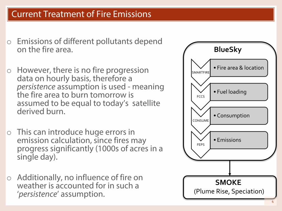
Current Treatment of Fire Emissions
o Emissions of different pollutants depend on the fire area.
o However, there is no fire progression data on hourly basis, therefore a persistence assumption is used - meaning the fire area to burn tomorrow is assumed to be equal to today’s satellite derived burn.
o This can introduce huge errors in emission calculation, since fires may progress significantly (1000s of acres in a single day).
o Additionally, no influence of fire on weather is accounted for in such a ‘persistence’ assumption.
SMARTFIRE• Fire area & location
FCCS• Fuel loading
CONSUME• Consumption
FEPS• Emissions
BlueSky
SMOKE(Plume Rise, Speciation)
4

Coupled fire-atmosphere model (WRF-SFire) feeding an AQ model (AIRPACT)
WRF framework (atmosphere):•ARW atmospheric core•WPS preprocessing system
Fire Spread Model:• Rothermel semi-empirical
fire spread model• Fire front tracking based
on the level set method
FIRE-GENERATED
HEAT AND MOISTURE
WRF SFIRE
FIRE-AFFECTEDWINDS
Fuel Moisture Model (Van Wagner and Pickett)• Drying and wetting
due to changes in T and RH
• Wetting due to rain• Explicit treatment of
different fuel classes
FUEL MOISTURE
Large scale weather initial and boundary conditions: •3km HRRR data, 5km NAM227, 12km NAM 218,12km NARRStatic data:•High-resolution topography•Land Use and Soil Data
High resolution fuel data:• 30m-resolution fuel
description • 30m-resolution elevation data• times and locations of
ignitions or fire perimeters• Initial fuel moisture
METEO INPUT
FIRE INPUT
High-resolution forecast including• plume height• wind speed and
direction• air temperature• air humidity• precipitation
High-resolution fire forecast including:•fire area•fuel moisture•fire heat flux
METEO OUTPUT
FIRE OUTPUT
Smoke air quality forecast
AIRPACT
Pre
cip,
Tem
p, R
H
5

Test Case – Cougar Creek Fire WA 2015
o Relatively isolated fire event starting Aug 11 2015 (limited smoke contribution from other fires), MISR plume height detection (later into the fire progression), well documented fire growth, fire area 53,534 Acres
o WRF-SFIRE domain setup: 4 nested domains of 12km, 4km, 1.33km, 444m horizontal resolutions, 41 vertical levels
o Fire mesh 22m, fuel and elevation data resolution 30 m (LANDFIRE)
o Single point ignitiono Initial and boundary conditions for the
atmospheric model from NARRo Coupled fire-atmosphere simulation
with two way coupling between fire and the atmosphere and between domains
o Simulation start 08.11.2015 00Z, fire ignition on 01Zo Simulation length 132h
d011212km
d02508km
d03129km
Firedomaind0443km

WRF-SFIRE Coupled Fire-Weather Simulation
7
o Simulated fire progression (fire area shown), 10m winds and smoke as a tracer

Simulated Fire Growth
oFire area observed, simulated by WRF-SFIRE, and projected (AIRPACT-5)
0
5000
10000
15000
20000
25000
30000
35000
40000
45000
50000
8/10/15 8/11/15 8/12/15 8/13/15 8/14/15 8/15/15 8/16/15 8/17/15 8/18/15
Fire
Are
a (A
cres
)
Date
Observations
WRF-SFIRE (1)
WRF-SFIRE (2)
AIRPACT-5
o In general, simulated fire area is closer to observations than the AIRPACT based on the assumption of fire persistence.
o Without any fire data assimilation in place, fire progression forecasts for more than 3 days will likely be associated with large errors.
o Simulated fire progression is sensitive to the fuel moisture used as an input into the model, therefore proper spatial 2D initialization of fuel moisture is very important.
8

Fire allocation based on WRF-SFire simulated fire area
444
m
444 m
o Orange area is hourly fire progression area
o Total fire area calculated for each grid cell
o Each grid cell acts as a single fire and has it’s own (hourly) area and location
o Thus, we use thousands of such grid cells as fire source
9

Different fire emission experiments
§ Base AIRPACT-5 caseo Fire emissions based on ‘persistence’ assumption
§ APFire-1 experiment o Hourly fire area integrated over an atmospheric grid cell size of 444
meters o Information of each fire grid cell is fed into BlueSky, representing a single
fire (each with its own location, fire size and heat flux)o Thus, a single base case fire is now represented by multiple smaller fires
§ APFire-2 experiment o Hourly fire area integrated over an atmospheric grid cell size of 444
metero Information of each grid cell is fed into BlueSky, representing a single fire
(each with its own location, fire size)o However, heat flux used in this case is the sum over all the pixels which
will increase the plume rise estimate
10

Integrating WRF-SFIRE with AIRPACT
o WRF-SFIRE resolves fire progression on 22-m resolution grid. The simulated fire area is then integrated over the 444-m atmospheric grid. Each grid cell containing an active fire is fed hourly into BlueSky as a separate fire with its own fire area and location
o For this test case over the whole simulation we fed BlueSky over 33,000 hourly fire records containing fire area and fuel moisture.
11
WRF-SFIRE Run for Cougar Creek Fire
Hourly Fire Area integrated to 444m
Fire Heat Flux
Plume HeightWRF-SFIRE
2 BlueSky converter
Hourly Fuel Moisture at 444m (1h, 10h, …)

Plume height comparison – APFire-1 vs. APFire-2
APFire2 – plume heights up to 2.8 km
APFire-1 plume heights up to 1.2km!
12

0
400
800
1200
1600
2000
2400
2800
1 21 41 61 81 101 121
Plu
me
heig
ht (m
)
Time (hr)
Ignition Point
0
400
800
1200
1600
2000
2400
2800
1 21 41 61 81 101 121Time (hr)
Western Point
0
400
800
1200
1600
2000
2400
2800
1 21 41 61 81 101 121Time (hr)
Southern Point
WRF-SFire – plume heights up to 2.5 km
Plume height comparison – WRF-SFire vs. SFire-2
APFire2 – plume heights up to 2.8 km
13

Average PM2.5 between APFire-1 and APFire-2
14
APFire-1 APFire-2

Simulated vs observed PM2.5 concentrations
15

Use of High Resolution Rapid Refresh (HRRR) for Nowcasting
o What is HRRR? From HRRR website (https://rapidrefresh.noaa.gov/hrrr/)
“The HRRR is a NOAA real-time 3 km resolution, hourly updated, cloud-resolving, convection-allowing atmospheric model, initialized by 3 km grids with 3 km radar assimilation. Radar data is assimilated in the HRRR every 15 min over a 1-h period adding further detail to that provided by the hourly data assimilation from the 13 km radar-enhanced Rapid Refresh”
o While HRRR uses WRF-ARW, public domain data is in grib2 format, and lacks several variables for driving CMAQ
16
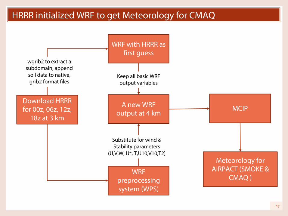
HRRR initialized WRF to get Meteorology for CMAQ
Download HRRR for 00z, 06z, 12z,
18z at 3 km
WRF with HRRR as first guess
MCIP
WRF preprocessing system (WPS)
A new WRF output at 4 km
Meteorology for AIRPACT (SMOKE &
CMAQ )
Substitute for wind &Stability parameters
(U,V,W, U*, T,U10,V10,T2)
Keep all basic WRF output variables
wgrib2 to extract a subdomain, append soil data to native, grib2 format files
17

Preliminary comparison of base WRF and HRRR
18

Development of Healthcare Demand App
o Healthcare demand app is under development as a part of EECS senior design projecto 2 semester project – will resume in fall
o Matt Kadlec (WA Ecology) has compiled a list of concentration response function (C-R functions) after extensive review of literature specifically focusing on wildfire impacts on health endpointso C-R function is smoke PM2.5 concentration - health response factoro These C-R functions together with AIRPACT-Fire forecasts and
population / demographic data will be used for developing the app
19

Smoke Concentration - Health Response functions
20
o Literature search for wildfire smoke health effects epidemiology studies o Found >300 articles
o Select studies with daily average PM2.5concentrations and measured daily changes in health care service/symptom rates (Relative Risks, etc.)o 16 articles report a range of cardiovascular and respiratory
effects
o Calculate C-R Functions
o Pool any C-R functions assessed in multiple studies, Examples:o Asthma emergency dept. visits (2 studies)o Ischemic heart diseases emergency dept. visits (2
studies)
o Compile pooled and single-study C-R functions in a risk calculation worksheet
o Transform AIRPACT-Fire PM2.5 forecasts to health risk forecasts using the C-R functions

Summary and Next Steps
§ Summaryo Successfully coupled WRF-SFIRE with AIRPACT air quality forecasting
system.o Between APFire-1 and APFire-2, we see an improvement in plume rise –
APFire-2 plume rise is more realistic compared to APFire-1.o APFire-2 has better prediction for some peak hours, but using this
approach also gives some false alarms. o Framework for using HRRR with CMAQ is in place, but more validation is
needed.o Health app development is in progress.
§ Next Stepso A wind field comparison between WRF-SFire and AIRPACT meteorologyo More investigation of plume height – such as using WRF-SFIRE plume
injection heights instead of Brigg’s approach in SMOKE.o Further coupling with AIRPACT – feeding heat flux directly from WRF-
SFIRE.o Testing & comparing HRRR based nowcasting system with AIRPACT-5
forecast.21
We acknowledge the funding agency:Joint Fire Science Program (JFSP)
22
Thank you !!
Questions / Comments?