upper devonian–lower mississippian clastic rocks in ...ky.aipg.org/guidebooks/2009...
TRANSCRIPT

Upper Devonian–Lower Mississippian clastic rocks in northeastern Kentucky: Evidence for Acadian alpine glaciation and models for source-rock and reservoir-rock development in the eastern United StatesFrank R. Ettensohn, R. Thomas Lierman, and Charles E. Mason with contributions by Sarah Heal, Niall Paterson, Cortland Eble, Robbie Goodhue, Nina Larsson, Geoff Clayton, Alan Dennis, Eric Anderson, and D. Brent Wilhelm
American Institute of Professional Geologists—Kentucky Section
Spring Field Trip
April 18, 2009

ContentsIntroduction ......................................................................................................................................1
Physiography along the field-trip route, I-64 in Bath and Rowan counties, Kentucky ...................1
Paleogeographic, paleoclimatic, and tectonic frameworks ..............................................................2
Field-trip roadlog and stops .............................................................................................................5
STOP 1: Silurian-Devonian contact and lower part of the Devonian black-shale section, northeastern Kentucky .....................................................................................................................6
STOP 2: Upper part of the black-shale sequence and lower Borden Formation ...........................15
STOP 3: Granitic dropstone embedded in the uppermost Cleveland Shale Member of the Ohio Shale ......................................................................................................................................27
Kentucky dropstone “ices” the case for Late Devonian alpine glaciation in the central Appalachians: Implications for Appalachian tectonics and black-shale sedimentation ................29
STOP 4: The Cowbell Member of the Borden Formation: Transition from delta front to delta platform .................................................................................................................................34
STOP 5: Borden delta destruction: The Nada Member of the Borden Formation .........................38
STOP 6: Transition between the Nancy and Cowbell members of the Borden Formation, northeastern Kentucky ...................................................................................................................41
Preliminary palynological results from the Late Devonian–Early Mississippian of Morehead and adjacent areas .........................................................................................................42
Appencix 1: Ichnofossils of the Borden Formation .......................................................................53

1
Upper Devonian–Lower Mississippian clastic rocks in northeastern Kentucky: Evidence for Acadian alpine glaciation and models for source-rock and reservoir-rock development in the eastern United StatesFrank R. Ettensohn, R. Thomas Lierman, and Charles E. Mason with contributions by Sarah Heal, Niall Paterson, Cortland Eble, Robbie Goodhue, Nina Larsson, Geoff Clayton, Alan Dennis, Eric Anderson, and D. Brent Wilhelm
IntroductionSituated at the margin of the Bluegrass area in central Ken-
tucky is a dissected escarpment supported by Devonian and Mis-sissippian shales, siltstones, and sandstones, sometimes called the “Highland Rim” or “Knobs.” The area is generally transitional between a planar, trough-like area on the Bluegrass Plain and the higher Pottsville escarpment of the Appalachian Plateau. On the eastern side of the Bluegrass area, the Highland Rim section con-tains Devonian and Mississippian black shales, called variously the Ohio, New Albany, Chattanooga, and/or Sunbury shales, over-lain conformably by the shales, siltstones, and sandstones of the Lower–Middle Mississippian Borden Formation. The Devonian–Mississippian black shales from this area, and from all of the east-ern and central United States, form one of the most prominent and economically significant stratigraphic intervals across the United States. They are major hydrocarbon source and reservoir rocks throughout the area and are currently being examined as poten-tial oil shales and trace-element sources. In eastern Kentucky, the fractured equivalents of these shales in the subsurface form the largest gas-producing field in the state, the Big Sandy Field. Moreover, the overlying Borden Formation delta sequence and its equivalents commonly form major reservoir rocks (Big Injun) in the subsurface. In addition, the fact that these rocks crop out along a major escarpment on which siltstones and sandstones generally overlie shales means that natural and human-made undercutting generates major mass-wasting-type engineering problems.
The time represented by these Upper Devonian to Middle Mississippian rocks represents a period of major paleogeographic, paleoenvironmental, and paleontologic change across the North American parts of the ancient continent Laurussia. Shallow-water carbonates and clastics with their attendant faunas characterized much of Laurussia, including foreland-basin regions, until Late Devonian time. Even the change from Laurentia to Laurussia, with the addition of Baltica in Early Silurian time, came and went without many changes in the shallow-water, carbonate-dominat-ed setting and biota on southern parts of the continent. With the imminent approach of Gondwana and progress of the Acadian/Neoacadian orogenies during the Middle–Late Devonian transi-tion, this all abruptly changed. After a period of uplift and erosion, large parts of southeastern Laurussia, including formerly stable cratonic regions, subsided and were inundated with basinal black shales followed by a major westward deltaic progradation that in-filled basinal areas. Shallow-water, carbonate-dominated, benthic biotas were abruptly replaced by ichnofauna and a deeper-water, restrictive, commonly planktic, depauperate biota in the basinal sediments. Although a sparse, benthic macrofauna returned dur-ing upper parts of the deltaic progradation, not until complete ba-sin infilling and the onset of delta destruction did an abundant, diverse, shallow-water, benthic fauna reappear in delta-destruc-tion units. Hence, on this one-day trip into northeastern Kentucky, shown on the map in Figure 1, we will examine the physical stra-
tigraphy and paleontology of the Upper Devonian–Middle Mis-sissippian, black shale–Borden delta sequence (Fig. 2) in light of its tectonic and environmental origins while at the same time noting its salient engineering and resource-related characteristics. In a new development, we will examine a large glacial dropstone embedded in the black shales and discuss its implications as evi-dence for the first reported tidewater glaciers and alpine glaciation in an ancient orogen.
Physiography along the field-trip route, I-64 in Bath and Rowan counties, Kentucky
Most of today’s trip takes place on an 18-mile-long stretch of eastbound I-64 from the Licking River to the KY State Route 799 overpass in Rowan County, Kentucky (Fig. 1), although to take advantage of exits off and onto the Interstate, the trip will have to go an additional 8 miles to the Owingsville exit 123 and then double back to pick up the first stop just east of the Licking River. Initial parts of the field-trip route on I-64 from the Owingsville exit to just beyond the Licking River are present in the Lexington Plains Section of the Interior Low Plateaus physiographic prov-ince (Fenneman, 1938) (Fig. 3). From the Owingsville exit, I-64 crosses the hummocky, irregularly rolling hills and low ridges of the Outer Bluegrass region, developed in this area on the Upper Ordovician limestones and shales of the Bull Fork and Drakes formations and on the Lower Silurian dolostones and shales of the Brassfield and Crab Orchard formations (McDowell, 1975, 1976) (Fig. 2). From the Owingsville exit, the highway drops about 100 feet into a broad trough at the foot of the Knobs, here largely pro-duced by erosion into soft, high-level, fluvial deposits and Crab Orchard shales.
The Knobs rise abruptly in front of the Licking River flood-plain and mark the beginning of the Knobs region of the Appa-lachian Plateau (Fig. 4). The Knobs form the lower part of the west-facing escarpment that defines the western margin of the Appalachian Plateau and marks the beginning of the Highland Rim (Fig. 4). In this area, the Knobs are about 300 ft (91 m) high and form a series of conical hills or detached ridges carved from the escarpment where erosion has cut through Silurian, Devonian, and Mississippian shales, leaving isolated rounded hills separated by wide valleys. East of the Licking River, the broad bases of the Knobs are generally developed in the nonresistant Lower Silu-rian Crab Orchard and Upper Devonian Ohio shales with resis-tant caps in the siltstones of Farmers or Cowbell members of the Borden Formation. During the first half day of the trip, we will largely examine rocks exposed where the valley bottoms meet the bases of several knobs. In the last half day of the trip, we will ef-fectively climb about 500 ft (131 m) up the Highland Rim through the Farmers, Nancy, Cowbell, and Nada members of the Borden Formation (Hoge and Chaplin, 1972; Philley et al., 1974). In this part of Kentucky, the Knobs and Highland Rim are included as

2
parts of the Pottsville Escarpment that defines the western margin of the Appalachian Plateau (Fig. 4). Typically the Pottsville es-carpment is a west-facing escarpment defined by resistant Lower Pennsylvanian, conglomeratic sandstones (Pottsville or Lee for-mations), but because Devonian and Mississippian outcrop belts are relatively narrow on the eastern side of the Cincinnati Arch and do not exhibit topography very different from that of Pennsyl-vanian rocks to the east, the Knobs and Highland Rim sections are effectively merged to form the Pottsville Escarpment (Ettensohn, 1992a).
Paleogeographic, paleoclimatic, and tectonic frameworks
Excluding the Lower and Middle Silurian Crab Orchard Shale at Stop 1, the ages of the rocks examined on this field trip range from Late Devonian (Famennian; Chatauquan) to Middle Mississippian (Visean; Meramecian) time, and based on the time scale of Gradstein et al. (2004) span an approximately 36-Ma in-terval of time from about 371 Ma to 335 Ma. During this time, North America, together with western Europe, formed the conti-nent Laurussia, and the field trip area was located about 25° south latitude in the subtropical trade-wind belt (Fig. 5), although by Middle Mississippian time the area had moved farther northward into more tropical latitudes (Ziegler, 1989).
The Devonian-Mississippian transition was a time of climatic and tectonic change. The Devonian-Mississippian black shales (Ohio and Sunbury shales) were deposited at the end of a global greenhouse state, a time of warm, equable climate with low latitu-dinal thermal gradients, high CO2 concentrations, and elevated sea levels (Fischer, 1984). Expanding seas and global warmth clearly enhanced organic productivity at a time when oxygen was becom-ing less soluble and may partially explain the great concentra-tions of organic matter preserved in the black shales that we will examine today (Ettensohn and Barron, 1981; Ettensohn, 1995,
1998). By the Early-Middle Mississippian transition during depo-sition of the Borden Formation, however, the seas became cooler (Mii et al., 1999) and overall sea levels dropped while exhibit-ing a pronounced cyclicity (Ross and Ross, 1988), all of which points to the advent of a global icehouse state and the inception of Gondwanan glaciation (Fischer, 1984), which might have begun as early as the Devonian-Mississippian transition (Frakes et al., 1992; Cecil et al., 2004; Brezinski et al., 2008).
At about this same time (360 Ma), Acadian/Neoacadian tec-tonism also reached a crescendo. Although the Acadian orogeny began late Early Devonian time (~411 Ma) following closure of the Iapetus Ocean and amassing of peri-Gondwanan Carolina and Avalonian terranes along the eastern margin of Laurussia, the main orogeny reflects dextral transpressional accretion of these terranes from the northeast to the southwest onto the southeastern margin of Laurussia (Ettensohn, 2008). The accretion occurred from the northeast to the southwest, perhaps reflecting the fact that the ter-ranes were caught in a pincers movement between Gondwana and the margin of Laurussia during the closure of the Rheic Ocean (Ettensohn, 2008; Nance and Linnemann, 2008) (Fig. 5). As trans-pressional accretion migrated slowly to the southwest, Laurussian continental promontories (remaining from the Iapetan rifting of Rodinia) were sequentially impacted by the terranes, generating particularly intense deformation at the promontories, such that each of the four Acadian/Neoacadian tectophases reflect intense deformation at a particular promontory (Ettensohn, 1985) (Fig. 6). The deformation generated at each promontory created suf-ficient deformational loading to support major basin subsidence and accompanying black-shale deposition as well as a succeeding clastic wedge. Inasmuch as the tectonics are transpressional along the margin of Laurussia, both foreland-basin black shales and clastic wedges developed in basins that paralleled the continental margin, and they migrated along basin strike in time (Ettensohn, 1987, 2004). Moreover, during each successive phase of orogeny,
Figure 1 Field-trip stops along and near I-64 in northeastern Kentucky.

3
Figure 2 The geologic section along the field-trip route with the relative stratigraphic positions of the sections viewed at each stop.

4
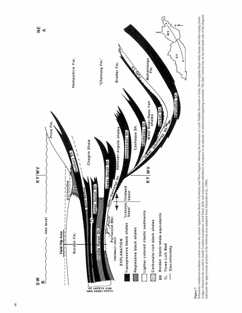
black-shale basins also migrated westwardly or cratonward, re-flecting the continued cratonward movement of deformation in time. By early Famennian time (about 371 Ma), the Appalachian Basin had filled with black shales and intervening clastic wedges such that subsequent basinal black shales were “pushed out” into cratonic seas just before deposition of the lower Huron Shale Member, as the Appalachian and Illinois basins yoked (Fig. 7) (Ettensohn et al., 1988a). We will examine this instant in time at the base of the Ohio Shale at Stop 1.
Transpressional accretion and the cyclic deposition of cra-tonic black shales and coarser clastics in the east-central United States continued until latest Devonian–Early Mississippian time, when apparently the Carolina, Avalon, and Meguma terranes all collided with Laurussia in the area of the New York promontory (Fig. 8). This event coincides with a Late Devonian–Early Mis-sissippian episode of magmatism, metamorphism, and deforma-tion in southern New England that has been called the Neoacadian orogeny (Robinson et al., 1998), although it represents the same event that has been termed the fourth tectophase of the Acadian orogeny (Ettensohn, 1985, 2008). This orogenic event generated sufficient deformational loading that foreland-basin black shales in the form of the Sunbury and Riddlesburg shales migrated back into the Appalachian basin and mountains high enough to support alpine glaciation were generated in the areas of the New York and Virginian promontories (Ettensohn, 2008; Ettensohn et al., 2008). The Sunbury Shale, which we will examine at Stop 2, is probably the most extensive, most organic-rich, and deepest-water shale in the Devonian-Mississippian black-shale sequence, and it is a product of the major deformational loading generated by this orogeny. Moreover, the likely dropstone that we will see embed-ded in the black shales at Stop 3 is evidence for the presence of alpine glaciation in high mountains generated by this orogeny.
An important part of the sedimentary record produced by this orogeny is a major, post-orogenic clastic wedge that overlies the Sunbury and equivalent shale units and is known variously as the Borden, Price, Pocono, or Grainger “delta complex” (Fig. 7); closely associated with these deltaic clastics are units like the Fort
Payne Formation (Ettensohn, 2004). We will examine parts of the Borden Formation at Stops 2, 4, 5, and 6. Most of the coarser clas-tic units associated with Devonian-Mississippian black shales are restricted to the Appalachian Basin and effectively helped to infill parts of the basin (Fig. 7). The Borden deltaic complex, however, is unusual in that it prograded beyond the Appalachian Basin, across the Cincinnati Arch and into the Illinois Basin (Fig. 9). The Borden Formation represents subaqueous parts of a westwardly prograding delta complex that formed as an early relaxational response to Neoacadian orogeny (Ettensohn et al., 2002, 2004; Ettensohn, 1994, 2004, 2005, 2008) (Fig. 10). Borden clastics filled remaining parts of the Appalachian Basin and deeper water seas on adjacent parts of the craton until early Visean (late Osag-ean) time, when due to bulge moveout and a sea-level lowstand, clastic sedimentation was diverted elsewhere so that a widespread period of sediment starvation ensued across east-central United States (e.g., Ettensohn et al., 2002, 2004). This period of sediment starvation is represented by the Floyds Knob Bed (Fig. 10), a thin, but widespread, interval of glaucony and phosphorite deposition, which will be examined at Stop 5. The Floyds Knob Bed com-monly occurs within the uppermost unit of the Borden Formation, the Nada Member, which is composed of fossiliferous, blue-green shales with interbedded carbonates and siltstones; it has been interpreted to represent delta destruction (e.g., Ettensohn et al., 2004) and will be viewed at Stop 5.
With the deposition of the Nada Member and its equiva-lents, the progradation of Borden deltaic clastics ended, and the stage was set for the deposition of Middle and Late Missis-sippian (mid-Visean–mid-Serpukhovian; late Osagean–middle Chesterian) carbonates throughout the Appalachian Basin (Fig. 10). The filling of the basin with Early and Middle Mississippian clastics, together with a sea-level lowstand in a subtropical set-ting, generated a widespread, shallow-water platform across the basin on which units like the Slade, Greenbrier, Newman, and Monteagle/Bangor/Tuscumbia limestones were deposited, locally with thicknesses greater than 500 m. About 13.5 m of shallow-
Figure 3 Physiographic diagram of Kentucky showing the location of the field-trip area as a “square” on the Pottsville escarpment in northeastern Kentucky. Areas west of the escarpment are included in Fenneman’s (1938) Interior Low Plateaus Province.

5
Figu
re 4
Sc
hem
atic
cro
ss se
ctio
n ne
ar I-
64 th
roug
h th
e ea
st fl
ank
of th
e C
inci
nnat
i Arc
h fr
om G
rays
on to
Lex
ingt
on, K
entu
cky,
show
ing
maj
or ro
ck u
nits
and
the
topo
grap
hy d
evel
oped
on
them
; fiel
d-tri
p ar
ea in
bra
cket
at t
op ri
ght
(ada
pted
from
Ette
nsoh
n an
d D
ever
, 197
9).
water Slade carbonates overlie the Nada Member of the Borden Formation at Stop 5; more information on the Slade carbonates can be found in Ettensohn and Dever (1979), Ettensohn (1980, 1981, 1992d, e), and Ettensohn et al. (2004).
Field-trip roadlog and stopsMileage
0.0 Thefieldtripwillstartat8:30A.M.inthepark-inglotbehindHardee’sandinfrontofFoodLionFoodstore.
0.1 ProceedfromparkinglottoPineCrestLaneandfollowittothejunctionofStateRoute32.
0.3 TurnleftontoStateRoute32andproceednorthtotrafficlight.
0.35 CenterofI-64overpass,FarmersMemberoftheBordenFormationexposedonbothsidesoftheroadinroadcuts.
0.4 AtlightturnleftontotheI-64westboundramp.0.8 I-64west.1.0 FarmersMemberoftheBordenFormation
outcropsonbothsideoftheroadinroadcuts.1.4 CrossNorthForkofTriplettCreek.2.1 UpperSunburyShale,aswellastheFarmers
andlowerpartoftheNancymembersoftheBordenFormation,exposedfor0.3milesonbothsidesofI-64inroadcuts.
2.6 UpperSunbury,aswellastheFarmersandlowerpartoftheNancymembersoftheBor-denFormation,exposedfor0.2milesonbothsidesofI-64inroadcuts.
2.95 CrossBullForkCreek.3.3 UpperSunburyShale,aswellastheFarmers
andlowerpartoftheNancymembersoftheBordenFormation,exposedfor0.4milesonbothsidesofI-64inroadcuts.
4.3 NancyMemberoftheBordenFormationexposedfor0.2milesinroadcuts,especiallyalongthewestboundlanes.
4.8 StateRoute801overpass.5.0 TopofOhioShale,BedfordShale,Sunbury
Shale,aswellastheFarmersandlowerpartoftheNancymembersoftheBordenForma-tion,areexposedfor0.3milesalongbothsidesoftheInterstate.
5.4 TheThreeLickBedoftheOhioShaleisexposedinaroadcutalongthewestboundlanes.
5.7 OhioShaleisexposedinaroadcutalongtheeastboundlanes.
6.0 OhioShaleisexposedinaroadcutalongtheeastboundlanes.
6.3 OhioShaleisexposedinaroadcutalongtheeastboundlanes.
7.0 OhioShaleisexposedfor0.4milesinaroadcutalongtheeastboundlanes.TheOlentangyandCrabOrchardformationsareexposedinthesameroadcutforthelast0.15milesatitswesternend.
7.4 StateRoute1722passesoverI-64.8.8 LickingRiverBridge.9.2 StateRoute219passesoverI-64.11.5 CrabOrchardFormationexposedinroadcut
alongthewestboundlanesfor0.1mile.

6
Figure 5 Late Devonian paleogeographic reconstruction of Laurussia (Old Red Sandstone Continent), showing the location of black-shale seas (adapted from Ettensohn and Bar-ron, 1981).
12.8 FeapingRoad,acountyroadcrossingoverI-64.13.3 CrabOrchardFormationexposedinroadcutalongthe
westboundlanes.13.7 CrabOrchardFormationexposedfor0.4milesinroad
cutsalongthewestboundlanesofI-64.NotethattheunderlyingBrassfieldFormationisexposedinthewesternpartoftheexposure.
14.4 Exit123;turnrightontoexitrampandfollowtojunctionofUS60.
14.8 JunctionofexitrampandUS60;turnleftontoUS60.14.9 EntrancerampforI-64east;turnleftontotherampand
proceedeasttoI-64.TheupperpartoftheBullForkFormationandtheoverlyingPreachersvilleMemberoftheDrakesFormationareexposedalongtheeastboundexitrampandalongtherightsideofUS60,continuingeast.
15.1 I-64east.15.5 TopoftheBrassfieldFormationandtheoverlyingCrab
OrchardFormationareexposedfor0.2milesalongtheeastboundlanesofI-64.
16.1 CrabOrchardFormationexposedinroadcutalongeast-boundlanesofI-64.
16.7 FeapingRoad,acountyroadcrossingoverI-64.18.0 CrabOrchardFormationexposedinroadcutalongthe
westboundlanesofI-64.20.4 StateRoute211passesoverI-64.20.8 LickingRiverBridge.22.2 StateRoute1722passesoverI-64.Alsobeginningof
roadcutalongeastboundlanesfor0.3mile,wheretheCrabOrchard,Olentangy,andlowerpartoftheOhioShaleareexposed.
STOP 1: Silurian-Devonian contact and lower part of the Devonian black-shale section, northeastern Kentucky Frank R. Ettensohn, Charles E. Mason, and R. Thomas Lierman
Stop 1 is a three-part stop beginning at what is commonly called the “Morehead exposure,” listed below as Stop 1A. This cut and successive cuts to the east along I-64 provide a complete exposure of the Devonian-Mississippian black-shale sequence in northeastern Kentucky. This is one of the most studied black-shale exposures in Kentucky (e.g., Chaplin and Mason, 1979; Kepferle and Roen, 1981; Ettensohn, 1992b, c; Lierman et al., 1992). The entire section is shown schematically in Figure 11, which includes an artificial gamma-ray log that can be used to discriminate and correlate black-shale units that are difficult to discriminate visu-ally (Ettensohn et al., 1979).
Mileage22.3 Stop 1A:I-64alongeastboundlanejusteastofState
Route1722overpassaftercrossingtheLickingRiverintoRowanCounty.AtthisstopwewillviewtheSilurian/De-vonianunconformitybetweentheCrabOrchardandOlen-tangyandthebasalHuronMemberoftheOhioShale.Latitude:38°,9’,51.9”;longitude:83°,35’,44.4”.
The section at Stop 1 begins with approximately 14.2 m (54 ft) of Lower and Middle Silurian, upper Crab Orchard Formation (Estill Shale Member). The unit is characterized by greenish-gray silty shale interbedded with thin-bedded, brownish-gray dolosil-

7
tites to dolarenites with occasional lenses of quartzose sandstone and siltstone (Fig. 12). Much of the shale is reported to contain volcanic ash (Mason et al., 1992; Mason, 2002). The dolostones occur in packets of three to five beds that are each typically 1.5–7.0 cm thick. Some of the thicker beds exhibit sharp erosional bases, subtle grading, mud chips, and hummocky crossbeds; each bed is typically burrowed from above. In the upper 1.8 m (6 ft), dolarenites and quartzose sandstones may occur as lens-like, com-pacted, starved ripples.
The uppermost 23 cm (9 in) are intensely weathered by oxi-dation to light brown to dark yellowish-orange colors, although iron oxides have accumulated in the shales to depths of at least 1.8 m. (6.0 ft), and manganese oxides and gypsum have accumulated to depths as great as 6.6 m (21.5 ft). Most of this weathering is as-sociated with a systemic disconformity that separates rocks of the Silurian and Devonian systems (Figs. 11, 12), but at many places regionally, the unconformity is angular. Although only a few me-ters of Middle Silurian Bisher Dolostone and uppermost Crab Or-chard Shale are missing here along the unconformity (McDowell, 1975), up to 135 m (443 ft) of Upper Silurian, Lower Devonian, and Middle Devonian section, which occurs to the north in Ohio or in the subsurface of eastern Kentucky, is absent in this outcrop belt.
Macrofossils have not been found at this exposure and are generally rare in the Crab Orchard. Nonetheless, at other Crab Or-chard exposures, specimens comprising a microfauna or juveniles have been recovered following washing and other processing. Fossils found include ostracods, graptolites, scolecodonts, cono-donts, sponge spicules and apparently juvenile forms of bryo-zoans, brachiopods, gastropods, pelecypods, crinoids, trilobites, nautiloids, and blastoids. Preservation is commonly by pyritiza-
tion or calcite recrystallization, and filter feeders and sessile forms seem to dominate (Mason et al., 1992; Mason, 2002).
The Crab Orchard shales typically form hummocky to gullied slopes, and where exposed without cover, they flow and slump, generating classic badlands topography. Hence, they form poor foundation material for homes and roads, but are impermeable enough to be good sites for farm ponds (McDowell, 1975; Mason, 2002).
The Crab Orchard Shale exposed here is Early to Middle Silurian (Late Llandovery, Telychian, to early Wenlock, Shein-woodian) in age and was deposited during the first tectophase of the Salinic orogeny, an Appalachian equivalent of the Scandian orogeny along the Caledonian suture (Ettensohn and Brett, 1998; Ettensohn, 2008). In this part of Kentucky, the unit represents very distal parts of the subsiding foreland basin, whose main axis of subsidence was in New York (Ettensohn, 1994). Subsidence was probably in large part tectonic, but glacio-eustacy may have also played a role in deepening at the time (Caputo, 1998; Ettensohn and Brett, 1998). The Crab Orchard at this locality is thought to represent offshore, outer-shelf deposition, generally below wave base. The presence of hummocky crossbedding, crude grading, and sparse ripples suggests that the interspersed dolostone and sandstone layers probably represent distal storm deposits or tem-pestites. Although presence of a normal-marine, pelagic micro-fauna suggests that upper parts of the water column were aero-bic, absence of typical larger-scale macrofauna, predominance of burrowing, a depauperate micromorph fauna, and presence of pyritization suggest that bottom waters were at least periodically dysaerobic. Although most dysaerobic faunas are typically domi-nated by vagile, molluscan deposit feeders or scavengers, in the Crab Orchard sessile, juvenile, filter-feeding bryozoans, brachio-
Figure 6 Schematic diagram showing tectonic framework of the Acadian/Neoacadian orogeny: A. Diachronous oblique transpression between Avalonian terranes and Carolina and southeastern margin of Laurussia; note that clastic wedges emanate successively from each promontory, and the Pocono-Price wedge is the subaerial part of the Borden delta; B. Geometry of oblique transpression (adapted from Ettensohn, 1987).
8
Figu
re 7
Sc
hem
atic
sout
hwes
t-nor
thea
st se
ctio
n ac
ross
the
cent
ral A
ppal
achi
an B
asin
in K
entu
cky
and
Wes
t Virg
inia
, sho
win
g th
e lo
catio
ns o
f cyc
lic M
iddl
e D
evon
ian
to E
arly
Mis
siss
ippi
an b
lack
-sha
le b
asin
s and
inte
rven
ing
clas
tic
wed
ges f
orm
ed in
the
seco
nd to
four
th A
cadi
an te
ctop
hase
s. Ea
ch b
lack
shal
e un
it re
pres
ents
subs
iden
ce in
resp
onse
to a
n ep
isod
e of
cra
tonw
ard-
mig
ratin
g te
cton
ism
. The
dar
k ve
rtica
l lin
e on
the
left-
hand
side
of t
he d
iagr
am
repr
esen
ts th
e ap
prox
imat
e po
sitio
n of
the
field
-trip
are
a (a
dapt
ed fr
om E
ttens
ohn
et a
l., 1
988)
.

9
Figu
re 8
N
eoac
adia
n te
cton
ic si
tuat
ion
that
gen
erat
ed th
e Su
nbur
y Sh
ale
(Sto
p 2)
, Bor
den
delta
(Sto
ps 2
, 4, 5
, and
6),
and
form
ed a
mou
ntai
n be
lt hi
gh e
noug
h to
supp
ort a
lpin
e gl
acia
tion
(Sto
p 3)
. A. L
ikel
y pr
e-A
cadi
an d
ispo
sitio
n of
m
icro
plat
es re
lativ
e to
Lau
russ
ia; B
. Lik
ely
disp
ositi
on o
f mic
ropl
ates
and
Gon
dwan
a du
ring
Neo
acad
ian
orog
eny.
Not
e th
e ea
stw
ard
limit
of th
e de
ep-m
arin
e Su
nbur
y Sh
ale
(see
Fig
. 7) a
nd it
s mar
gina
l-mar
ine
equi
vale
nt,
the
Rid
dles
burg
Sha
le (a
dapt
ed fr
om E
ttens
ohn,
200
8).

10
pods, and crinoids predominate. More information on this unit and its faunas can be found in studies by Mason et al. (1992) and Mason (2002).
The disconformity separating Silurian and Devonian rocks in this section is one of the most significant unconformities in Ken-tucky (Fig. 12), and it marks the base of Sloss’s (1963) Kaskaskia cratonic sequence. Nearly everywhere in the state there is a major unconformity like this below the black-shale sequence, although different amounts of time and section are missing in different places. At this section, approximately 59 Ma of Silurian and De-vonian time are missing along the surface, but the surface is ac-tually a composite unconformity, having subsumed at least four Early and Middle Devonian periods of erosion based on more complete sections in the subsurface of eastern Kentucky. Most of the erosion probably occurred during Middle and Late Devo-nian time near the beginning of the second and third tectophases of the Acadian orogeny accompanying bulge moveout. At places along the unconformity, a pyritized lag horizon, no more than 7 mm thick, contains quartzose sand, phosphorite particles, fossil fragments, and conodonts. Conodonts from the lag reflect parts of five Late Devonian (Frasnian–early Famennian) conodont zones (Pa. crepida–Pa. asymmetricus zones), encompassing about 10 Ma of subaqueous erosion and particulate accumulation (Etten-sohn et al., 1989). Although the lag reflects a long period of sedi-ment starvation and erosion, the accumulation of oxides and other weathering products in upper parts of the Crab Orchard may also reflect periods of subaerial weathering and soil development, al-though the possibility of interstratal weathering below the pyrite-rich black shales cannot be ruled out (Ettensohn, 1992b).
Overlying the unconformity and lag is 0.8 m (2.6 ft) of un-fossiliferous, light greenish-gray, clay shale with rare black-shale laminae of the upper Olentangy Shale (Figs. 11, 12). In central Ohio, Middle and Upper Devonian gray shales, separated by an unconformity, are included in the Olentangy Shale; upper parts of the unit are Late Devonian in age, whereas lower parts are Middle Devonian in age (e.g., Woodrow et al., 1988). Here, only the thinning western edge of Upper Devonian parts of the unit is preserved, hence the name “upper Olentangy.” This unit has been traced through subsurface correlations into the Hanover Shale of New York (Wallace et al., 1977). Although the upper Olentangy is lithologically correlative with the homotaxial Hanover Shale of New York, conodont studies indicate that the two units are not time equivalent (Ettensohn et al., 1989; Ettensohn, 1992b; Fuentes et al., 2002). In fact, the upper Olentangy is three conodont zones younger (Pa. rhomboidea Zone in Kentucky) than the Hanover Shale (lower Pa. triangularis Zone in New York), a time span of about 3 Ma (Woodrow et al., 1988; Gradstein et al., 2004). Inasmuch as the upper Olentangy and Hanover shales represent deeper-water, dysaerobic, prodelta environments that formed in a migrating foreland basin, the homotaxial and diachronous nature of the units provide a way of estimating bulge and foreland-basin migration. In this particular case, rates of basin-and-bulge mi-gration were on the order of 37 km/million years (23 mi/million years) or about 0.4 m/yr (1.3 ft/yr) (Ettensohn, 1992b). Moreover, by upper Olentangy–lower Huron time (early Famennian), the foreland basin had filled to overflowing, and Acadian tectonism had migrated far enough cratonward that parts of the Cincinnati Arch subsided, allowing the Appalachian and Illinois basins to yoke (Fig. 7).
Overlying the upper Olentangy Shale is 13.4 m (44 ft) of fissile, pyritic, black shale with interbeds of greenish-gray, clay shale at its base (Figs. 11, 12). This part of the Ohio Shale has been called the lower Huron Shale Member and it has been cor-
Figure 9 Relative distribution of Acadian/Neoacadian clastic-wedge, delta complexes on southern Laurussia. The delta complexes migrated south in time tracking the progress of Acadian/Neoacadian transpression. The Borden-Grainger (BG) complex is the subaqueous equivalent of the Price-Pocono (PP) subaerial delta; it is the product of the Neoacadian orogeny and was the last and largest of the Aca-dian/Neoacadian deltas. Major basins are defined by inward-pointing tick marks; intervening arches by lines with diamonds (after Ettensohn, 2004).

11
Figure 10 Schematic east-west cross section across the central Appalachian basin, showing likely succession of flexural events between the last Acadian/Neoacadian tectophase (A) and inception of the Alleghanian orogeny (F) and their sedimentary/stratigraphic responses relative to units in the central Appalachian Basin and along the field-trip route. On the field-trip route we will examine units from events A through D (adapted from Ettensohn 1994, 2004).

12
Figure 11 Schematic stratigraphic column for the section at Stop 1, showing the respective stratigraphic disposition of stops in the section. The radioactivity profile to the left is an artificial gamma-ray log that can be used for correlations in the surface or subsurface in homogeneous black shales.
related with the Dunkirk black shales of New York (e.g., Wallace et al., 1977), although like the Olentangy and Hanover shales, they are homotaxial, but diachronous, by about three conodont zones or 3 Ma (Woodrow et al., 1988; Ettensohn et al., 1989; Ettensohn, 1992b; Fuentes et al., 2002; Gradstein et al., 2004). The lower Huron is a typical transgressive black shale (Fig. 7), being more widespread, more organic-rich, and more radioactive than the overlying, regressive black shales of the middle Huron Member (Ettensohn, 1992b) (Fig. 11). The lower Huron forms the large positive deviation at the base of the black-shale sequence (Fig. 11), and because of its high organic content (8–23 percent by weight), its shales are typically “pulpy” and weather to form very fissile “paper shales” like those exposed at this stop (Fig. 13). Interpretations based on geochemistry (e.g., Perkins et al., 2008) suggest that the black paper shales of the lower Huron were deposited in anoxic conditions, whereas overlying parts of the black-shale sequence more likely represent deposition in suboxic conditions.
The base of the lower Huron contains greenish-gray shale interbeds that are well known for their trace fossils (Barron and Ettensohn, 1981). The fossils are most prominent in the gray shales but many of the burrows penetrate from the gray shales into the underlying black shales where the former gray-mud infillings stand out against the black muds. Apparently, organisms from the dysaerobic gray muds were “mining” organic matter from un-derlying black muds in which they were unable to live because of anoxia. Common trace fossils include Zoophycos, Planolites, Phycodes, Chrondites, Teichichnus, and Rhizocorallium (Griffith, 1977; Jordan, 1980), which, according to Griffith (1977) and Jor-dan (1980), reflect the Nereites ichnofacies of Seilacher (1967) and represent the basal, slightly shallower parts of an upward-deepening, basin sequence. The apparently rapid alternation be-tween gray and black muds may have represented oscillations at the base of the pycnocline caused by relatively rapid changes in subsidence or sea-level. The only other common fossils in the lower Huron include the ubiquitous green algal spores of Tasman-

13
Figure 12 The section a Stop 1A (Fig. 11), showing the Crab Orchard, upper Olentangy, and lower Huron shales. The student is pointing to the Silurian-Devonian paraconformity, the rust-stained horizon. Trace fossils are very common in the interbedded black and green shales at the base of the lower Huron. Note the prominent jointing in the lower Huron Shale.

14
ites and coalified logs that floated out into the basin, became wa-terlogged, and sank to the bottom.
Aside from burrowing in the lower part of the Huron and in other gray-shale units in the black-shale sequence, fossils are rela-tively rare in the unit. Plankton (spores, chitinozoans, algae, and radiolarians), nektoplankton (ostracods, conodonts), epiplankton (brachiopods, pelecypods, crinoids, and graptolites that attached to floating logs), and nekton (fish remains and cephalopods) have been locally reported (e.g., Barron and Ettensohn, 1981). Benthic forms are extremely rare, suggesting that bottom waters were in-hospitable, probably due to anoxia. However, when benthic forms do occur, they are invariably Lingula- and Orbiculoidea-like in-articulate brachiopods.
Black shales are major gas producers in the Appalachian Ba-sin (approximately 3 tcf to date), and the lower Huron Member is the primary gas-producing unit in the entire basin (Boswell, 1996). In fact, the Big Sandy Field of eastern Kentucky and south-western West Virginia, encompassing an area of more than 3,500 km2 (1,260 mi2), accounts for more than 80 percent of black-shale gas production in the Appalachian Basin, and most of that is from the lower Huron Shale Member (Boswell, 1996). Although the shale itself has very little permeability, the rock forms the source, reservoir, and seal. The gas is stored as free matrix gas, as gas adsorbed onto clay minerals and organic carbon, and as gas in a system of open natural fractures. As a result, gas production is re-gionally variable, depending on organic-carbon content, the thick-ness of organic-rich zones, thermal maturity, and the presence of natural fracture systems. Commonly, it is from the organic-rich, transgressive-shale facies, which we are observing at this stop, and the transition interval into the overlying middle Huron Mem-ber that most of the production is obtained (Kubic, 1993). Natural fracturing, of course, is critical in generating suitable reservoirs, and as you can see in this exposure the shale is nearly always jointed; unfortunately, little work has been done on characteriz-ing regional joint patterns. In this exposure, there are prominent joint sets running approximately north-south and east-west. How-ever, in natural or man-made exposures, these joint sets make the black shale inherently unstable and subject to rock fall or top-pling, where the shale is exposed overlying the weak Silurian and Devonian gray shales.
Because of an abundance of organic matter in the shales, higher concentrations of radioactive and heavy metals are rela-tively common in the form of organo-metallic-clay complexes. As a consequence, waters emanating from the shales may have
higher-than-normal concentrations of these elements and have an “iron” or “sulfurous” taste and smell due to the breakdown of the abundant pyrite in the shales. The presence of these metals and other contaminants from the shale may contribute to a higher in-cidence of cancer reported from people who live on these shales. Building on the shales can also be problematic. Access by wa-ter and air into the shales during building typically causes pyrite breakdown, and sulfate produced from the breakdown may con-tribute to gypsum formation. Together, these breakdown process-es may lead to substantial heaving in the shales that can severely disrupt foundations and destroy overlying structures.
Mileage22.5 Stop 1B: I-64alongtheeastboundlane0.2mieastof
Stop1A.AtthisstopwewillviewtheProtosalvinia (Foer-stia)ZoneinthemiddlepartoftheHuronShaleMemberoftheOhioShale.Latitude:38°,10’,0.0”;longitude:83°,35’,13.3”.
Near the east end of the exposure, we will climb up above the paper shales of the lower Huron to a level just above the next bench. Near the base of this bench, the middle Huron Shale be-gins (Fig. 11). The middle Huron is composed of about 25 m (82 ft) of “ribbed,” regressive, black shales, which contain horizons of interbedded gray shales near the base and top of the unit. The regressive shales contain more clastic constituents, mainly in the form of quartzose laminae, and less organic matter (4–7 percent). Moreover, they are easily distinguished from transgressive black shales by the presence of “ribbing.” Each “rib” is a few inches thick and alternates with a reentrant of less resistant shale. The ribs protrude more because they apparently contain more clastic-rich laminae than adjacent shales, and hence, are more resistant. This cyclicity is present throughout most of the Devonian black shales in the western Appalachian Basin, and although the cycli-city has not been definitely explained, it may reflect some type of regional climatic cyclicity in the source area that periodically resulted in greater clastic influx to the basin.
These regressive black shales thicken eastward into the distal parts of major clastic wedges, and the middle Huron Shale is a black-shale equivalent of the lower part of the greenish-gray Cha-grin Shale to the north and northeast (Fig. 7). As distal parts of the Chagrin clastic wedge prograded westward, sediments from the east apparently entered deeper parts of an anoxic cratonic basin in which organic matter was preserved; so in many ways, regres-sive black shales show the same general clastic composition as do their eastern, greenish-gray shale equivalents, except that they were deposited below the pycnocline where more organic matter could be preserved (Ettensohn et al., 1988a).
What is especially interesting about this exposure is that the basal 3 m (10 ft) of the middle Huron contain interbedded gray and black shales that coincide with the widespread Protosalvinia (Foerstia) Zone (Fig. 11). Only about 2.3 m (7.6 ft) of the zone are exposed at this site. Protosalvinia is an enigmatic planktic, plant(?) fossil that has been interpreted to represent a possible brown alga (Phillips et al., 1972; Schopf and Schwietering, 1970) or an organism with early land-plant affinities (Schopf, 1978; Ro-mankiw et al., 1988). It commonly has two forms, a bifurcating lobate thallus (Fig. 14) and an elliptical, reproductive structure (Fig. 15). At any one locality, either the thallus or elliptical form predominates, but in some localities the zone is represented only by fragmented debris; at this locality, the elliptical form seems to dominate. This fossil appears to occur at approximately the same relative stratigraphic horizon throughout the Devonian black shales of east-central United States, making it a potentially impor-
Figure 13 “Pulpy” paper shales, or transgressive black shales, from the lower part of the Huron Member of the Ohio Shale at Stop 1a.

15
tant stratigraphic time marker (Hasenmueller et al., 1983). Recent conodont work shows that Protosalvinia may occur across parts of three conodont zones (Pa. trachytera–lower Pa. expansa), and at least locally, the zone may be related to a regional unconformity (Over et al., 2009). Additional information may be found in Etten-sohn et al. (1989) and Ettensohn (1992c).
Mileage22.9 OhioShaleexposedinroadcutfor0.4milesalongthe
eastboundlanesofI-64.23.8 OhioShaleexposedinroadcutalongtheeastbound
lanesofI-64.24.1 Stop 1C:I-64alongtheeastboundlane,1.6mieast
ofstop1B.Atthisstopwewillviewfromafar(acrosstheInterstate)theThreeLickBed,whichseparatestheunderlyingHuronMemberfromtheoverlyingClevelandMemberoftheOhioShale(Fig.11)alongthewestboundlaneofI-64.Latitude:38°,10’,45.9”;longitude:83°,35’,6.8”.
At this stop we will quickly view from afar a section of the Three Lick Bed of the Ohio Shale (Provo et al., 1978). The Three Lick Bed is a prominent stratigraphic marker horizon (mid-Fa-mennian, lower Pa. expansa Zone; Over et al., 2009) that consists of three thin beds of greenish-gray shale separated by two beds of ribbed black shales; the lower gray-shale bed is largely covered with slope debris at this exposure. It is recognized on gamma-ray logs by three closely spaced negative deviations separated by two positive deviations (Fig. 11). The unit thins to the west and south where the gray shales become little more than bioturbated black-shale horizons and the three, negative, gamma-ray deviations merge into a larger single one; in fact, the unit varies in thickness from nearly 40 m (152 ft) in far eastern Kentucky to just a few centimeters thick in central Kentucky (Ettensohn et al., 1988a). The unit has also been traced to a thin, bioturbated interval of the Clegg Creek Member, New Albany Shale, in the west-central Il-linois Basin (Ettensohn and Geller, 1987). Gray shales in the unit may be intensely bioturbated, and benthic organisms, including in situ Lingula-like inarticulate brachiopods, agglutinated foramin-ifera, ostracods, as well as micromorph gastropods and pelecy-pods have been reported (Barron and Ettensohn, 1981).
The Three Lick Bed represents the distal-most tongues of prodelta Chagrin Shales (Fig. 7) from northern Ohio (Provo et al., 1978) and from equivalent Catskill and Hampshire delta progra-dation to the east. The gray shales represent three brief dysaerobic periods, during which bottom waters coincided with the pycno-cline, in a cratonic basin whose bottoms were otherwise below the pycnocline in anoxic conditions. Apparently the bed represents three brief periods of sea-level lowstand that coincided with major deltaic progradations from the north and east. Sands in equivalent beds to the east produce hydrocarbons from the drillers’ Gordon and Venango sandstones and siltstones (Boswell et al., 1996).
Mileage24.4 Exit133;turnrightontoexitramp.24.5 FarmersMemberoftheBordenFormationisexposedin
roadcutsalongtherightsideoftheramp.24.8 JunctionofI-64andStateRoute801;turnrightonto801
andgoeast.26.5 TheSunburyShale,aswellastheFarmersandlower
partoftheNancymembers,areexposedinaroadcutalongbothsidesoftheroadfor0.2mile.TheBedfordanduppermostpart(upperClevelandMember)oftheOhioShaleareexposedontheleft,ornorth,sideofStateRoute801.
26.95 JunctionofStateRoutes1722and801;turnrightontoStateRoute1722andturnaround.Pleasenotethatdi-rectlyacrosstheroadatthelevelofthefirstbenchintheroadcutistheThreeLickBedoftheOhioShale,whichseparatestheunderlyingHuronMemberfromtheoverly-ingClevelandMember.TurnleftbackontoStateRoute801,headingwest.
STOP 2: Upper part of the black-shale sequence and the lower Borden Formation R. Thomas Lierman, Charles E. Mason, and Frank R. Ettensohn
At Stop 2 we will examine the well-exposed upper part of the Ohio Shale (Cleveland Shale Member), the Bedford Shale, Sunbury Shale, and lower parts of the Borden Formation, includ-ing the Henley Bed, Farmers Member, and Nancy Member (Figs. 16, 17).
Mileage27.3 Stop 2.Pullofftheroadtotheguardrailontheright.
Stop2islocatedinaroadcutalongthenorthboundlaneofStateRoute801,1.75misouthofexit133from
Figure 14 Bifurcating lobate thalli of Protosalvinia.
Figure 15 Round to elliptical reproductive bodies of Protosalvinia. These are the most common fossils at Stop 1b.

16
InterstateHighwayI-64.Theexposureis0.35minorthofthejunctionofStateRoutes801and1722inthesouth-centralpartoftheFarmersquadrangle,RowanCounty,Kentucky(Figs.1,2).Latitude:38º09’08”;longitude83º33’6.5”.
The base of this section begins with the upper part of the Upper Devonian Cleveland Shale Member of the Ohio Shale and continues up section through the Bedford Shale (uppermost De-vonian). The Bedford is in turn unconformably overlain by the Mississippian Sunbury Shale, which is followed in succession by the Lower Mississippian Farmers and Nancy members of the Bor-den Formation. The Borden sequence here represents the lower portion of a prograding delta sequence. A stratigraphic section at this stop is shown in Figure 17.
Unit 1, Cleveland Shale Member (Ohio Shale). Unit 1 consists of 4.25 meters (14 ft) of the Cleveland Shale Member of the Ohio Shale Formation (Fig. 17). This shale is a brownish-black to black, fissile, organic-rich, silty shale. It is pyritic with an occasional siderite or phosphate nodule scattered throughout. In weathering it tends to take on a dusky yellowish-brown to yellowish-orange color. Both body fossils and trace fossils are rare within the unit, though upon close inspection, one can occasionally come across a few linguloid brachiopods, conodonts, and fish remains (teeth, scales, bones). In viewing the shale from the side, one can also see that the weathered surface of the outcrop has a ribbed appearance (Fig. 18). This ribbing consists of smoother faced promontories
and more splintery-weathering recessed intervals, which average about 5 cm thick. The recessed intervals are likewise carbonaceous shales but with slightly lower organic content than the smoother faced promontories. The lower organic content apparently allows these intervals to weather more rapidly.
The environment of deposition is best described as a deep-water, anoxic or anaerobic, basin-floor environment. Anaerobic conditions are found where oxygen levels are less than 0.1 ml of O2 per liter of water. A number of considerations lead us to that con-clusion. First, the black color of the shale is due to the presence of finely disseminated organic matter within the shale. This typically occurs under stagnant or reducing conditions; that is, conditions where there is a lack of free oxygen in the water or sediment and where anaerobic bacteria are present. A second line of supporting evidence comes from the observation that there is a near absence of any body fossils or trace fossils within these shales. The few fossils that are found tend to represent organisms that maintain a nektic or planktic lifestyle.This lifestyle is certainly reflected in the conodonts and fish remains, and the few inarticulate brachio-pods we find were probably epiplanktic, attached to floating logs or floating vegetation such as Sargassum-like seaweed; benthic fossils are completely absent from these shales. A final piece of evidence within these organic-rich shales is the presence of pyrite (FeS2) along with some nodules of siderite (FeCO3). Both of these mineral phases tend to form under Eh conditions that are reducing or (–) negative (Garrels and Christ, 1965, p. 224).
Figure 16 Photo showing the upper part of the stratigraphic section at Stop 2 (see Fig. 17). The upper part of the Ohio Shale can be seen in the distant cut in the background, and the Cave Run Lake fauna is present on uppermost bench in the photo.

17
Figure 17 Schematic stratigraphic section from the outcrop at Stop 2 (see Fig. 16).

18
These anaerobic conditions more than likely formed in a ma-rine basin in which the vertical water column was density strati-fied. Density stratification is generally related to differences in water temperature or salinity. In this case, warmer or less saline surface water would sit atop colder or more saline bottom wa-ters. Such differences in water temperature and/or salinity would in turn generate a distinct pycnocline or zone of rapid density change between surface and bottom waters. If this difference was pronounced enough, it could effectively cut off circulation between bottom and surface waters. The bottom waters would in turn become oxygen deprived, provided that they were below the euphotic zone and not allowed to circulate freely with oxygen-rich surface waters (Fig. 19). The organic matter in this instance could have come from either a planktic source flourishing in the upper parts of the water column, or as detrital plant remains de-rived from the terrestrial land plants, because by Middle and Late Devonian time, vascular land plants had established a firm foot-hold on the land surface. This colonization of the land included true arboreal species (forests), tree-size plants with woody stems, complex vascular systems, leaves, and even the first appearance of seeds. The sudden appearance of so many plant groups and growth forms has been called the “Devonian Explosion” (Algeo et al., 1995).
As stated previously, the ribbed character of these shales (Fig. 18) is probably related to variations in the organic content of the shale. This cyclic increase and decrease in organic carbon could have several explanations. One explanation might be a pe-riodic increase and decrease in the abundance and productivity of phytoplankton in the water column. Periods of high productiv-ity would result in an increase in the relative amount of organic matter in the shale; periods of lower productivity would provide the sediment with less organic matter. A second explanation could involve variations in the amount of terrigenous sediment reaching the depositional basin. In this case an increase in the percentage of fine-grained mud would result in a decrease in the relative amount of organic matter incorporated into the sediment. Conversely, a decrease in the percentage of terrigenous mud would translate to an increase in the relative amount of organic matter in the shale. A third possibility might relate to cyclic variations in the amount of detrital organic matter derived from terrestrial plants living on the land surface. Streams draining recently colonized Devonian lands would have carried an increased amount of organic matter, primarily in the form of plant detritus. This organic detritus would have eventually been transported into deeper parts of the basin and become incorporated into the fine-grained sediments of the Ohio Shale. Conceivably, variations in the amount of terrestrial
Figure 18 “Ribbed” black shales from Cleveland Member of the Ohio Shale at Stop 2.

19
plant matter reaching the basin bottom could have caused differ-ences in the amount of organic matter preserved in the shales.
Devonian, marine, black-shale deposits are quite notable for their widespread occurrence across the inland seas of North America and Eurasia (Fig. 5). Algeo et al. (1995, 1998) suggested that these deposits were the result of the huge influx of organic matter and nutrients from an increasingly vegetated landscape. In addition to causing eutrophication in these broad epicontinental seas, terrestrial plants may have also contributed to changes in the speed and pattern of soil formation, which led to accelerated weathering of silicate minerals. This chemical weathering pro-cess, called hydrolysis, is a reaction involving water, H+ or OH– ions, and silicate minerals. The byproducts of hydrolysis include various clay minerals (e.g., kaolinite, illite), orthosilicic acid (H4SiO4), along with the generation of bicarbonate (HCO2
–). This reaction can effectively remove CO2 from the atmosphere and ulti-mately tie it up in the carbonate-silicate geochemical cycle. These weathered bicarbonates enter rivers and are ultimately transported to the oceans where they precipitate as various carbonate minerals and are eventually buried in marine sediments.
The burial of extensive quantities of organic carbon and inorganic bicarbonate could have eventually led to reduced at-mospheric CO2 levels. Algeo et al. (1995, 1998) suggested that the loss of this greenhouse gas may have contributed to a major global cooling event during Late Devonian time. The very “green-ing” of the continents by terrestrial land plants could have acted as a carbon-dioxide sink, and atmospheric levels of this greenhouse gas may have dropped substantially. This in turn would have cooled the climate and possibly resulted in an intense episode of glaciation near the end of Devonian time. This is most evident in parts of Gondwanaland from South America (Brazil, Bolivia, and Peru) to parts of central Africa (Central Africa Republic and Niger) (Crowell, 1999). Possible evidence for this period of gla-ciation may also be found much closer to home, as we will see later on in this trip. More information and interpretations regard-ing the Cleveland and related black shales can be found in papers by Ettensohn and Barron (1981), Ettensohn et al. (1988a), and Perkins et al. (2008).
Unit 2 (Bedford Shale). The Bedford Shale consists of 7.9 meters (25.9 ft) of medium- to olive-gray mud shale that is poorly fis-sile and noncalcareous. Scattered within this shale are very thin, discontinuous beds and lenses of argillaceous siltstone along with siderite nodules and irregularly shaped masses of pyrite. Also dis-seminated throughout the shale are small crystals of pyrite, which occur as cubes and octahedra. Some of the siltstone beds show a faint hint of rippling along their upper surfaces. The unit as a whole appears highly bioturbated, though individual trace fossils
are difficult to discern or identify; horizontal burrows filled with pyrite are locally common. Body fossils (chonetid brachiopods and gastropods) can be found at this location, though they are sparse. They are most commonly found in pyrite nodules. The lower contact of the Bedford with the underlying Ohio Shale is in places marked by intercalated layers of gray shale and black, fissile shale, which in places appear to be bioturbated.
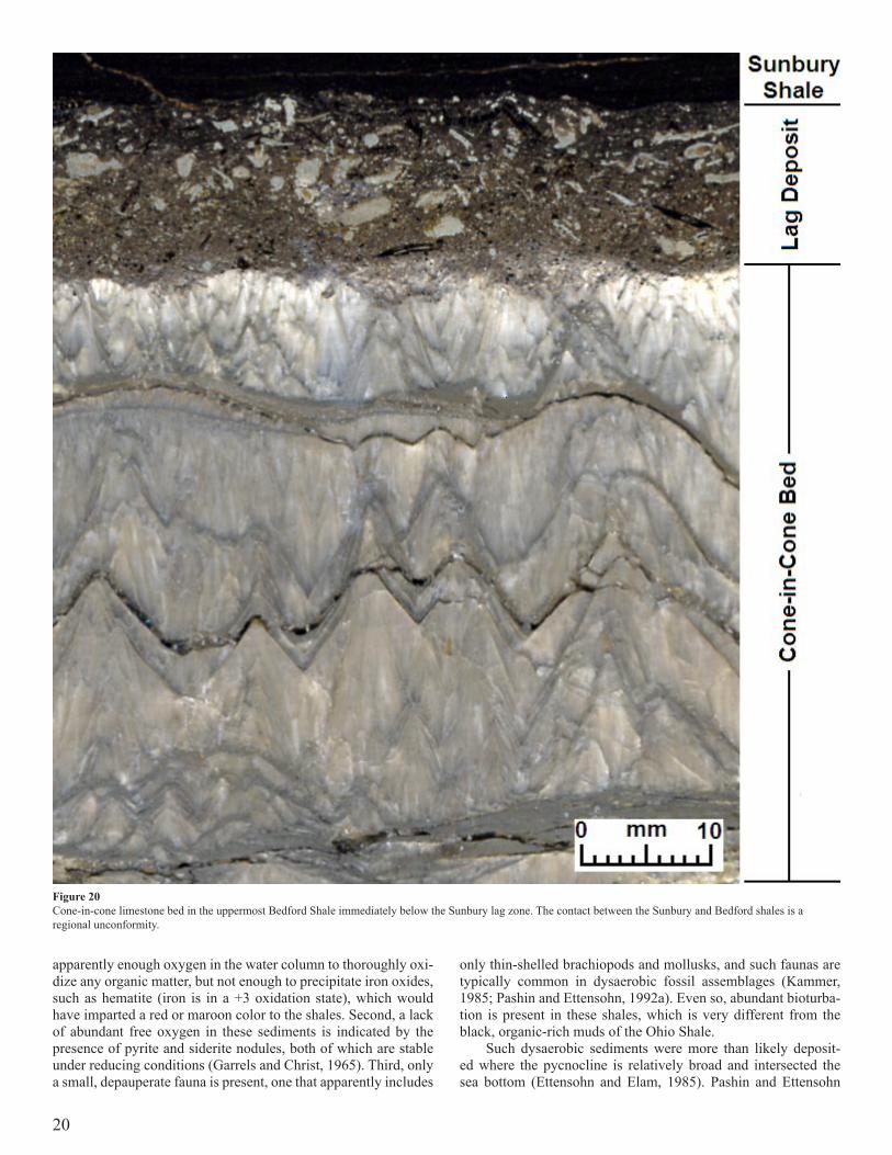
At the top of the Bedford, a well-developed cone-in-cone limestone layer, approximately 5.5 cm (2.1 in) thick, is locally present (Fig. 20). Cone-in-cone is a secondary sedimentary struc-ture that has the appearance of a series of cones packed one inside the other. Close inspection reveals that the apices of the cones are mostly directed upward, and there seems to be a concentration of clays and organic matter along the margins of many cones. Petro-graphic examination of the cones reveals that they are composed of fibrous calcite, with the fibers tending to be parallel to the sides of individual cones. Stylolites are also associated with these cone-in-cone structures, suggesting that both the cone-in-cones and the stylolites are formed by the same process of pressure solution-ing.
At this locality, the lower contact of the Bedford with the Ohio Shale is broken by what appears to be several low-angle thrust faults (Figs. 21, 22). Thrusts like this are highly unusual for the area, and this is the first time such features have been observed. These thrusts strike at approximately N74ºE and dip at an angle of about 5º to the north. We are fairly confident that these are small thrust faults because we can see the displacement of the black shale as it has been thrust up and over the gray Bedford Shale, which is in turn thrust over the top of the black shale. A close-up view of a thrust is shown in Figure 21, and an outcrop-scale view of several thrusts is shown in Figure 22. Slickensides associated with surfaces in the black shale, local intrusion of plastic gray shales into the black, as well as several unusual joints that extend out from the thrust at angles of 47º to 68º from the thrusts pro-vide additional evidence for the interpretation. These structures may reflect a subsurface response to growth faulting along nearby basement structures at depth (e.g., Drahovzal and Noger, 1995) or they may reflect mass movement from another dimension. In ei-ther case, the gray shale tends to behave more plastically, whereas the black shales tend to act more competently.
Deposition of the Bedford probably occurred in a dysaerobic setting. Dysaerobic environmental conditions exist where dis-solved oxygen levels in the water or sediments are between 0.1 and 1.0 mil of O2 per liter of water. The evidence for this setting is first of all the color of the shale. The gray-green color of these shales is due to the presence of greenish phyllosilicates (e.g., il-lite, chlorite).The iron content in these minerals is key as the Fe is in a +2 oxidation state (ferrous iron). In this situation, there was
Figure 19 Cartoon illustrating possible means (stratified water column) for the isolation and preservation of organic matter in the Devonian black shales.
20
apparently enough oxygen in the water column to thoroughly oxi-dize any organic matter, but not enough to precipitate iron oxides, such as hematite (iron is in a +3 oxidation state), which would have imparted a red or maroon color to the shales. Second, a lack of abundant free oxygen in these sediments is indicated by the presence of pyrite and siderite nodules, both of which are stable under reducing conditions (Garrels and Christ, 1965). Third, only a small, depauperate fauna is present, one that apparently includes
only thin-shelled brachiopods and mollusks, and such faunas are typically common in dysaerobic fossil assemblages (Kammer, 1985; Pashin and Ettensohn, 1992a). Even so, abundant bioturba-tion is present in these shales, which is very different from the black, organic-rich muds of the Ohio Shale.
Such dysaerobic sediments were more than likely deposit-ed where the pycnocline is relatively broad and intersected the sea bottom (Ettensohn and Elam, 1985). Pashin and Ettensohn
Figure 20 Cone-in-cone limestone bed in the uppermost Bedford Shale immediately below the Sunbury lag zone. The contact between the Sunbury and Bedford shales is a regional unconformity.

21
(1992b, 1995) envisioned the Bedford Member as part of a delta complex that included the black shales of the Cleveland Mem-ber, the Bedford Shale, and Berea Sandstone. In this model, the Cleveland Member formed under anaerobic to dysaerobic, basin-floor conditions, whereas the Bedford Shale is thought to repre-sent the slow accumulation of muddy sediments at distal margins of a mud-rich turbiditic slope under more dysaerobic conditions. The related Berea Sandstone, which is not present in this area, was interpreted to represent a series of storm-dominated shelf deposits in northeastern Kentucky (Pashin and Ettensohn, 1987, 1992, 1995) (Fig. 23). However, recent ideas about the possibility of Late Devonian, Acadian/Neoacadian, alpine glaciation, which we will discuss at Stop 3, suggest that Bedford shales from east-ern sources may reflect distal lowstand deposits related to alpine glaciation in Acadian/Neoacadian highland source areas to the east. More information and interpretations relative to the Bedford Shale can be found in papers by Pepper et al. (1954), Chaplin and Mason, 1979; Ettensohn and Elam (1985), and Pashin and Etten-sohn (1987, 1992a, b, 1995).
Unit 3 (Sunbury Shale). The Sunbury Shale at this locality con-sists of 4.75 meters (15.6 ft) of dark-gray to black, highly carbo-naceous, fissile shale (Fig. 17). The unit contains small pyritic nodules as well as small, scattered pyrite crystals. Overall, the lithology of the Sunbury Shale is comparable to that of the Ohio
Shale below, and this includes a similar ribbed appearance when viewed from the side. The uppermost part of the shale tends to be bioturbated with burrows infilled by greenish-gray shale similar to the overlying Henley Bed. Fossils are quite sparse within the unit but may include rare linguloid or orbiculoid brachiopods, as well as conodonts.
The lower contact of the Sunbury with the underlying Bedford Shale is quite sharp and characterized by a 1.5-cm-thick “lag” de-posit (Fig. 20). This lag lies immediately above the cone-in-cone layer previously mentioned in the Bedford Shale (Fig. 20) and contains a variety of both pyritized and phosphatic fossil remains, including inarticulate linguloid and orbiculoid brachiopods, a variety of conodonts, as well as phosphatic fish debris including teeth, scales, spines, and broken dermal plates. It also contains a concentration of what appears to be reworked pyritized burrows. The fragments in this lag also commonly exhibit reverse grad-ing (Fig. 20). This basal layer or zone is apparently recognized throughout the entire outcrop area of the Sunbury Shale (Pepper et al., 1954), and in this area, that basal lag separates Devonian and Mississippian rocks and defines a major regional unconfor-mity (Ettensohn, 1994).
Considering the similarities between the Sunbury Shale and the underlying Cleveland Shale, it is likely that the depositional conditions of this unit were very similar to those of the Cleveland for all the same reasons. We therefore interpret the Sunbury Shale to represent the slow accumulation of fine-grained muds in the very deepest portion of a basin-floor environment in anaerobic conditions. The only difference is that the Sunbury was depos-ited during Early Mississippian (early Tournaisian; early Kinder-hookian) time. The Sunbury represents the most widespread, most organic-rich, and deepest of the black-shale, basinal environments present in the Devonian-Mississippian black-shale sequence. Un-like the underlying Devonian black-shale units, which migrated westward in time during deformational loading (Fig. 7), the Sun-bury represents a trangression and subsidence event that moved eastward in time (Fig. 7), apparently reflecting inception of a new, more proximal Neoacadian convergence event to the east (Fig. 8B). Additional information and interpretations regarding the Sunbury can be found in papers by Chaplin and Mason (1979, 1985), Ettensohn and Elam (1985), Mason and Lierman (1985), Ettensohn et al. (1988a), and Lierman et al. (1992).
Unit 4, Henley Bed, Farmers Member (Borden Formation). The Henley Bed is the basalmost unit of the Borden Formation (Figs. 16, 17). Here it consists of 1.7 m (5.6 ft) of greenish-gray to grayish-green mud shale that is poorly fissile and noncalcare-ous. The unit as a whole appears to be highly bioturbated, though individual trace fossils are difficult to discern. In addition to the shales, the unit contains three thin (approximately 5 cm thick) beds of argillaceous siltstone along with one very thin bed of ar-gillaceous dolostone. Body fossils are rare at this locality; howev-er, microfossils are abundant and diverse and include conodonts, spores, and arenaceous foraminifera.
The lower 10 cm of the Henley bed at this locality is Early Mississippian in age (early Kinderhookian) and corresponds to the lower Siphonodella crenulata Zone of Sandberg et al. (1978), based on the presence of the conodont species Siphonodella cren-ulata Branson and Mehl. Above this and up to the thin dolomite bed, about 50 cm above the base, no conodonts have been recov-ered at this locality. However, at other sites across Kentucky and Ohio, the upper Siphonodella crenulata Zone has been identified. At approximately 30-cm below the first siltstone bed at this locali-ty, the conodont species Polygnathus communis carinus and Pseu-
Figure 21 Close-up view of Cleveland black shales thrust over Bedford gray shales in an erosion gully at Stop 2

22
dopolygnaths multistriatus have been found. Below this interval and extending down to the dolomite bed previously mentioned, another interval lacking conodonts occurs. P. communis carinus and P. multistriatus have also been recorded from a 1-m inter-val at the base of the Nancy Member at this location, and these two forms indicate an Early Osagean age (equivalent to the Fern Glen or early Burlington formations) for this part of the interval (Work and Mason, 2005). For this reason the contact between the Kinderhookian and Osagean is placed at the thin dolostone layer about 50 cm above the base of the Henley Bed.
The Henley Bed is thought to represent the slow accumula-tion of fine-grained sediments in deep prodelta environments at the foot of the prograding Borden delta. Henley Bed sediments mark the inception of basin infilling, following anaerobic, Sun-bury, basinal sedimentation (Fig. 7). The environment was dys-aerobic and dominated by hemipelagic muds, which were peri-odically interrupted by an influx of silt and very fine sand from occasional turbidity currents, reflected by the thin siltstone beds found in the Henley. The shales and mudstones of the Henley Bed, as well as those of the overlying Farmers Member, were deposited during relatively long periods of time by slow accumulation and probably represent the indigenous sediments that would have nor-mally accumulated in this relatively deep-water, prodelta environ-ment. The siltstones and sandstones in the Henley and overlying Farmers Member represent brief intervals of rapid sedimentation through the intrusion of turbidity currents or density currents as they periodically disrupted the generally quiet, deep-water setting. Additional information and interpretations about the Henley bed
can be found in papers by Chaplin and Mason (1979), Chaplin (1980, 1982, 1985), and Mason and Lierman (1985, 1992).
Unit 5, Farmers Member (Borden Formation). The Farmers Member is the lowermost member of the Borden Formation (Figs. 16, 17). At this locality the Farmers consists of 5.2 meters (17.1 ft) of interbedded sandstones/siltstones and shales. The unit contains tabular-bedded, very fine-grained sandstones to coarse-grained siltstones that alternate with mud shales. The coarser grained sandstone/siltstone beds range from 22 to 65 cm (9 to 26 in) thick at this location. These beds are light brownish-gray to yellowish-brown and are composed principally of quartz, rock fragments and mica. The matrix is chiefly clay, siderite, and microcrystal-line quartz. Individual beds tend to be size graded, with the lower portion of beds consisting of very fine-grained sand. This in turn grades upward into coarse- to medium-grained silts and eventu-ally into silty muds. The finer grained shales are greenish-gray mud shales to silty shales that occur as partings and interbeds be-tween the coarser grained layers. Grayish-red siderite nodules and lenses also occur throughout the unit and are especially common in the shale interbeds. The shales range from 5 to 32 cm (2 to 12.6 in) thick at this locality.
Sedimentary structures in the Farmers include internal struc-tures, sole marks and trace fossils. The lower surfaces of the sand-stone/siltstone beds exhibit very abrupt contacts with the underly-ing shale and have an abundance of sole marks. These sole marks include tools marks, such as groove, brush, prod, and bounce casts. The most abundant tool marks are groove casts. Measure-
Figure 22 Outcrop view of repeated Cleveland and Bedford section at Stop 2, showing the likely location of thrust surfaces involved.

23
Figu
re 2
3 D
epos
ition
al m
odel
for t
he B
edfo
rd-B
erea
sequ
ence
in e
aste
rn K
entu
cky
and
Wes
t Virg
inia
. (af
ter P
ashi
n an
d Et
tens
ohn,
198
7).

24
ments of paleocurrent directions from the sole marks in the Farm-ers show a trend from east to west. This paleocurrent direction is consistent with the downslope movement of material from east to west off the Borden delta front (Moore and Clarke, 1970). The upper surfaces of the coarse-grained beds tend to grade into the overlying shales and show extensive evidence of bioturbation.
Internal sedimentary structures within the coarser grained beds include parallel laminae, current ripple laminae, and convo-lute laminae. The coarser grained beds commonly exhibit a lower interval of parallel laminae overlain by current-ripple laminae or convolute laminae, followed by an interval of parallel laminae, which is in turn overlain by shales (see insert in the stratigraphic section for this stop, Fig. 17). This sequence more than likely cor-responds to a truncated Tb-Te interval of Bouma’s classic turbid-ite sequence (Bouma, 1962).The graded interval Ta at the base of Bouma’s sequence (Fig. 24) is absent here, which is probably due to the overall fine-grained nature of the rocks.
Body fossils can also be found throughout the Farmers but tend to be locally restricted to certain beds or siderite nodules. Megafossils that do occur are mainly found as molds, and include productid and spiriferid brachiopods, fenestrate bryozoans, cri-noid columnals, gastropods, cephalopods, conularids, trilobites, hexactinellid sponges, and bivalves. The associated fauna seem to have been a stable shelf, benthic fauna that had been transported into this deeper water setting, although some may have been nek-tic or nektobenthic.
Trace fossils are very common features in these rocks and are most generally found along the upper and lower surfaces of the coarser grained beds and include the ichnogerera Zoophy-cos, Lophoctenium, Sclarituba, Teichichnus, Palaeodictyon, and Chondrites (see Appendix 1). Escape burrows or fugichnia that frequently extend from the base to the top of many of these beds are also common. These trace fossils are representatives of both the Zoophycos and Nereites ichnofacies and mainly reflect graz-ing and feeding traces.
A turbidity current or density current is the downslope move-ment of dense, sediment-laden water, created when sand and mud
along a shelf or slope are dislodged and thrown into suspension. The resulting deposit is generally found at the base of the slope and is called a turbidite. Turbidity flows are recognized by their graded bedding and by a unique sequence of sedimentary features known as a Bouma Sequence, which includes a characteristic se-quence of sedimentary structures deposited by the turbidity cur-rent; these were first described by Arnold Bouma in 1962. At the base of the sequence is a massive, coarse-grained, graded bed (Ta) deposited as the turbidity current passes. Overlying this is parallel-laminated sand (Tb), a rippled sand/ silt (Tc), and finally, a parallel-laminated layer of mud or silt (Td), all reflecting the waning carrying capacity of the current (Fig. 24).
The Farmers Member is thought to be a series of turbidite de-posits that accumulated at the outer edge of a prograding Borden delta (Fig. 25). Evidence for this interpretation is quite substan-tial. First, the sharp or erosional contacts of the lower surfaces of individual beds within the Farmers suggest rapidly moving currents capable of scouring away the sediments over which it flowed. Secondly, the lower surfaces of many of these beds have an abundance of tool marks, again suggesting rapidly moving cur-rents. These tool marks tend to be oriented in an east-to-west di-rection, suggesting that the paleocurrents responsible for forming these structures were moving down a westward facing paleoslope. Third, the fact that the grain size of any individual bed decreas-es from the base to the top of each bed suggests that the current responsible for depositing these sediments was one whose flow velocity was decreasing as it was being deposited. Fourth, the abundance of escape burrows in many of these beds suggests that these sedimentary layers were deposited fairly rapidly, potential-ly trapping any organisms living in the area and forcing them to quickly burrow up through the offending sediment layer. Another observation is that most of the trace fossils are found along upper surfaces of these beds, again suggesting that these sediment layers were deposited rapidly, and that once deposited, stable conditions returned once again. Stable conditions would have allowed bur-rowing organisms to rework the upper surfaces of the sediment layers. Finally, the close match between a Bouma sequence and the sequence of sedimentary structures found in any individual
Figure 24 Five-part division of a classic Bouma cycle, showing an ideal sequence of sedimentary structures found in a turbidite bed (adapted from Walker, 1979).

25
bed in the Farmers is striking (Fig. 17). Taken together, this evi-dence suggests that the Farmers Member was deposited as a series of distal turbidites along the basal slope of the Borden delta com-plex (Fig. 25). The only part of any Farmers Bouma sequence that is missing is the Ta interval, probably reflecting the fact that these sediments started out as fine-grained sands and silts; the flows simply had no coarser grained sediments with which to work.
Moore and Clarke (1970) were the first to suggest that the Farmers Member was of turbiditic origin because it exhibited many of the features found in a typical Bouma Sequence. Howev-er, it should be noted that the Farmers was deposited in a cratonic setting rather than the more classic deep geosynclinal setting. The Farmers sequence clearly represents turbidite sedimentation at the base of a westward facing paleoslope that extended into deep, quiet-water environments of the Appalachian Basin in eastern and east-central Kentucky. Paleocurrent analysis suggests that the source was to the east in the Appalachian highlands. This paleo-slope was the leading edge of the Borden delta complex that built out from these highlands. Kepferle (1977) also concluded that the Farmers Member in eastern Kentucky and a similar unit in east-central Kentucky, the Kenwood Siltstone, were both deposited as turbidite sequences. He interpreted these units as fanning out from two depositional centers along the front edge of this prograding delta platform. According to Kepferle (1977), the front edge of this delta marked the very outer edge of the Catskill-Pocono clas-tic wedge that first began to build westward in Late Devonian
time (Fig. 26). More information and interpretations regarding the Farmers Member can be found in papers by Moore and Clarke (1970), Ettensohn (1979), Chaplin (1980, 1982, 1985), Mason and Lierman (1985, 1992), and Chaplin and Mason (1979).
Unit 6, Farmers/Nancy Transition (Borden Formation). The Farmers/Nancy Transition zone, an informal unit designated by Chaplin (1980), consists of 3.9 m (12.8 ft) of interbedded shale and siltstone (Figs. 16, 17). The shale is a greenish-gray, silty shale to mud shale that is poorly fissile, noncalcareous, and exten-sively bioturbated. The shale intervals range from 55- to nearly 110-cm thick (21.5 to 43.7 in). Grayish-red siderite nodules and lenses also occur throughout the unit and tend to be concentrated in distinct layers. Some of the nodules are fossiliferous and may contain brachiopods, fenestrate bryozoans, pelecypods, gastro-pods, or conularids. Located within these shales are four siltstone beds whose thicknesses vary from 13 to 27 cm (5 to 10.5 in). The siltstones are again turbiditic in origin and have characteristics identical to the beds in the underlying Farmers Member. Along the lower surfaces of each bed is an abundance of sole marks, including groove casts, load casts, and various tool marks. Trace fossils are also very common along the upper surface of the tur-biditic siltstones with Zoophycos being the most abundant. Body fossils can be collected from the siderite nodules found in the interval. This transition interval is an informal designation, as it
Figure 25 Block diagram showing interpreted depositional environments of the typical lithofacies of the Sunbury and Borden formations in the Morehead area, east-central Ken-tucky (adapted from Kepferle, 1977).

26
Figure 26 Paleogeographic map showing the development and progradation of the “Borden Delta Complex” in Kentucky, Indiana, Illinois and Ohio in Early Mississippian time (adapted from Kepferle, 1977).
simply separates the thicker bedded sands of the Farmers Member below from the shales of the Nancy Member above.
Unit 7, Nancy Member (Borden Formation). At this locality, the Nancy Member, is incompletely exposed (Figs. 16, 17) and consists of 8.7 meters (28.5 ft) of greenish-gray to grayish-green mud shale to silty shale that is poorly fissile, non-calcareous, and highly bioturbated. The shale contains an abundance of siderite nodules, both scattered within the unit and concentrated in dis-tinct beds or layers. These nodules can be highly fossiliferous and heavily mineralized. There is also a zone of phosphate nodules located some 2.5-m above the contact with the unit below. Body fossils include a variety of open-marine forms, including brachio-pods, gastropods, cephalopods, fenestrate bryozoans, crinoid de-bris, solitary rugose corals, and occasionally conularids.
Intrepretation. The Nancy Member is interpreted to be a prodelta deposit (Fig. 25), formed as the “Borden delta complex” prograd-ed across east-central Kentucky. The upper parts of this unit were mainly deposited in an aerobic environmental setting, whereas lower portions of the Nancy, as well as the Farmers Member, were
probably deposited under somewhat dysaerobic conditions that developed in the basinal seas in which these units were deposited. These conditions indicate a stratified water column in which bot-tom waters were anaerobic, lower waters were dysaerobic, and middle and upper waters were aerobic.
Evidence for dysaerobic conditions during deposition of the lower Nancy and Farmers members includes: (1) The overall gray-green color of the shale, indicating the presence of greenish phyllosilicates; (2) the abundance of siderite nodules, a mineral that forms under reducing conditions (Garrels and Christ, 1965); and (3) the presence of a dysaerobic fauna (the Cave Run Lake fauna; Fig. 17) near the base of the Nancy Member (Mason and Kammer, 1984; Mason and Work, 2005).
Aerobic conditions in the upper part of the Nancy Member are evidenced by: (1) The presence of an open-marine fauna, (2) the high degree of bioturbation of these shales, resulting in a near-ly complete homogenization of the sediment, (3) the occurrence of delta-front sands and silts of the Cowbell Member, which con-formably overlie the Nancy Member (Fig. 25). Additional work and interpretations regarding the Nancy Member can be found

27
in papers by Mason and Chaplin (1979), Chaplin (1980, 1982, 1985), Mason and Lierman (1985, 1992), and Work and Mason (2005).
Economically, farther north in Kentucky, the Berea Sand-stone commonly occurs in facies relationship with the Bedford Shale (e.g., Pashin and Ettensohn, 1987, 1992, 1995), and the Be-rea is an important hydrocarbon reservoir rock, generating many major oil and gas fields in eastern Kentucky and adjacent parts of Virginia, West Virginia, and Ohio (e.g., Tomastik, 1996). The Be-rea, however, reflects more proximal deltaic, fluvial, and platform environments, and this part of Kentucky was too far basinward to support these kinds of deposits (Ettensohn, 1979). However, in lower parts of the overlying Borden Formation, the turbiditic silt-stones of the Farmers Member do form another series of reservoir rocks called the Weir Sandstone in the subsurface (Matchen and Vargo, 1996). As indicated above, the Farmers is a package of tur-biditic siltstones/sandstones in prodelta mudstones equivalent to the Nancy Member and Henley Bed. However, in the subsurface of eastern Kentucky there are many such packages of turbiditic siltstones and sandstones in the same setting, but not necessarily of the same exact age as the Farmers, and hence, there may be several different Weir Sandstones in the subsurface. Where these siltstones have developed sufficient natural or fracture porosity, they may form important hydrocarbon reservoirs (Matchen and Vargo, 1996). More information and interpretations regarding the Nancy Member can be found in papers by Mason and Chaplin (1979), Chaplin (1980, 1982, 1985), Mason and Lierman (1985), Lierman et al. (1992a, b), and Work and Mason (2005).Mileage29.1 EntrancerampontoeastboundI-64.29.4 I-64East;NancyMemberoftheBordenFormationex-
posedalongbothsidesofI-64,especiallyalongthewest-boundlanes.
30.2 SunburyShalethroughthelowerpartoftheNancyMemberoftheBordenFormationareexposedalongbothsidesofI-64for0.4mile,especiallyalongthewestboundlanes.
30.9 BridgeoverBullForkCreek.31.0 SunburyShalethroughthelowerpartoftheNancy
MemberoftheBordenFormationareexposedalongbothsidesofI-64for0.4mile.
31.5 SunburyShalethroughthelowerpartoftheNancyMemberoftheBordenFormationareexposedalongbothsidesofI-64for0.3mile.
32.5 BridgeoverNorthForkofTriplettCreek.32.7 FarmersMemberoftheBordenFormationisexposed
alongbothsidesofI-64for0.2mile.33.0 Exit137(Moreheadexit);turnrightontoramp.33.4 JunctionofI-64andStateRoute32;turnleftontoState
Route32andproceedwest.Note:TheFarmersMemberoftheBordenFormationisexposedinthearearoadcuts.
33.5 CrossunderI-64.33.6 FirsttrafficlightafterpassingunderI-64.33.7 TrafficlightatjunctionofroadtoTrademoreShopping
Center.34.0 BridgeoverNorthForkofTriplettCreek.34.1 TrafficlightatjunctionofBrattonBranchRoadandac-
cessroadtoWal-Mart;turnleft.34.15 Stopsign;turnleftagainontoBrattonBranchRoad.34.4 SlumpedFarmerssiltstoneblocksalongrightsideof
road.
34.5 UpperBedfordShalethroughthelowerpartoftheFarm-ersMemberoftheBordenFormationareexposedinaroadcutalongtherightsideoftheroadfor0.3mile.
35.2 BridgeoverLoganBranch.
STOP 3: Granitic dropstone embedded in the uppermost Cleveland Shale Member of the Ohio Shale R.Thomas Lierman, Charles E. Mason, Frank R. Ettensohn, and Geoff Clayton
At this stop we will examine the unusual occurrence of a probable granitic dropstone, called the Robinson boulder, in up-permost parts of the Cleveland Shale Member of the Ohio Shale and its implications.
Mileage35.25 Stop 3.Immediatelyaftercrossingbridge,turnleftonto
adirtroad.WewillparkhereandwalkupLoganHollowRoad0.2milestoStop 3.AftervisitingStop3,wewillretraceourroutebacktothejunctionofBrattonBranchRoadandU.S.32.Stop3islocatedalongacreekcalledLoganHollowBranch,approximately0.2milesnorthofaroadbridgelocatedatthejunctionofBrattonBranchandLoganHollowroads.Itislocatedintheeast-centralpartoftheMoreheadquadrangle,RowanCounty,Kentucky;seeFigure1.Latitude:38º11’36.1”;longitude83º29’36.6”.
Stratigraphically, the boulder occurs at the very top of the Upper Devonian Cleveland Member of the Ohio Shale (Fig. 27). The Bedford Shale can be easily dug out along the bank of the stream where it overlies the Cleveland Shale. Mispores from both the Cleveland Shale and basal Bedford Shale at this locality are assigned to the LN Biozone. Continuing down the creek on the eastern side, a more complete section including both the Bedford and Sunbury shales is present. A stratigraphic section of this stop is shown in Figure 27.
Statistics:Granite boulder: First discovered by Michael J. Robinson
of NYTIS Exploration Company LLC in January 2006. This was brought to our attention on July 8, 2006.
Size and Shape: The boulder is a roughly square-shaped mass that projects from the Cleveland Shale on the bottom of the creek along Logan Hollow. The sides of the boulder are flat while the corners and edges are rounded. The top may be faceted (Figs. 28, 29).
Size: 1.3 x 1.7 m (4.3 x 5.6 ft).Thickness: Approximately 0.60 m (2.5 ft).Density: 2.70 g/cm3; most granites fall in a range of 2.7 to
2.8 g/cm3.Estimated Weight: Approximately 3 tons.Lithology: Originally a biotite granite; it has been subjected
to low-grade metamorphism.Mineralogy: Quartz, K-feldspar (microcline), biotite mica
(Plate 1).Petrology: Thin-section examination of samples from the
granite boulder show that it has been subjected to low-grade (greenschist) metamorphism. This level of metamorphism is in-dicated by the presence of highly strained quartz crystals, along with composite quartz grains in the granite. Bent or kinked biotite has in places been altered to chlorite. In addition, much of the feldspar (microcline) is replaced by a mosaic of calcite crystals.

28
Age: Zircon crystals extracted from the boulder provided an Early Ordovician concordia age of 474 ±5 Ma. Some of these ex-hibited inherited cores with a Grenvillian age of 1,156 ± 230 Ma (Ettensohn et al., 2008).
Interpretation. Taking into account the size, weight, shape, and exotic lithology of this boulder, we think that it is an ice-rafted dropstone that was transported to and then released from a melting iceberg at this site. We suggest that this is the result of alpine glaciation that was occurring in the Acadian highlands some 200–250 miles east of this locality. Most paleogeographic
Figure 27 The stratigraphic section in Logan Hollow Branch at Stop 3.
Figure 28 Top view of the granite boulder. Note the flattened sides, faceted top, and rounded corners of the boulder. Scale is 1 ft.

29
reconstructions for this time period place Kentucky and the Aca-dian mountains at around 30º south latitude. For this object to be found in rocks from a marine setting, such as is represented by the Cleveland Member, suggests that these glaciers would have had to extend from the Acadian highlands westward to sea level, with icebergs calving off along the western edge of these glaciers.
Support for this hypothesis comes from several lines of evi-dence. (1) The lithology of the boulder is similar to Grenville-age granites in the region of the central Appalachian highlands. In particular, the bluish tint to the quartz has been noted by several authors in Grenville-age granites in the central Appalachian re-gion. (2) The age of the granite boulder is in keeping with the ages of other rocks in the Appalachian region. Zircons were extracted from the boulder, which give an Early Ordovician concordia age of 474 ±5 Ma. A number of these zircon crystals had inherited cores with a Grenvillian age of 1,156 ± 230 Ma. The boulder clearly had an early Appalachian or Laurentian origin. (3) The overall shape of this boulder with its flat sides and rounded edges and corners is in keeping with the shape of other glacial erratics. During the course of their movement, rocks that are embedded within a glacier grind against other rocks or can scrape against the underlying bedrock. In the process, this rounds off corners and planes smooth surfaces on embedded rocks, eventually produc-ing this characteristic appearance. This process is also responsible for the generation of glacial striations and polished surfaces on the glacial erratics; unfortunately, this has not been observed on this boulder, though we are not able of see the bottom surface of the boulder. It should be noted that less than 10 percent of glacial erratics actually have striations on them. (4) Probably the best
argument is that we simply have no other mechanism that could explain the presence of a large, 3-ton granite boulder deposited in the middle of an epicontinental sea, as the boulder was clearly penecontemporaneous with the Devonian sediments in which it is embedded. The only other mechanism that could potentially transport an object of this nature is root-rafting. Root-rafting is a transport mechanism that begins when soil and rocks get tangled up in the root systems of uprooted trees. These fallen trees, along with any soil and rock embedded in their roots, are later picked up by floodwaters and transported downstream to the sea. Root-raft-ing can probably be excluded, however, because the root systems of Late Devonian trees were apparently not sufficiently developed to wrap around and transport objects of this size and weight. All references to root-rafting that we have found to date involve rocks that are no larger than pebbles or cobbles in size.
This fascinating subject is discussed in greater detail in the following article. More information can be found in abstracts by Lierman and Mason (2007) and Ettensohn et al. (2007, 2008).
Kentucky dropstone “ices” the case for Late Devo-nian alpine glaciation in the central Appalachians: Implications for Appalachian tectonics and black-shale sedimentation F.R. Ettensohn, R.T. Lierman, C.E. Mason, A.J. Dennis, and E.D. Anderson
Abstract. Upper Devonian diamictites from the eastern Appala-chian basin, previously interpreted as debris-flow deposits, are
Figure 29 Boulder is clearly embedded in the Cleveland Member of the Ohio Shale Note upturned layers or “mud drape” along edges of boulder.

30
glacial in origin based on well-defined stratigraphic, biostrati-graphic, tectonic, and paleogeographic connections with a newly discovered in-situ dropstone from Upper Devonian black shales in east-central Kentucky. Together, the dropstone and diamictites, nearly 500 km apart, provide the first reported evidence for alpine glaciation in an ancient orogen and for tidewater glaciers in an ancient foreland basin. Both occurrences are related to an Aca-dian/Neoacadian transpressional regime that generated proximal foreland-basin subsidence and high coastal mountains in a paleo-climatic setting conducive to alpine glaciation. The 474-Ma age of the dropstone lithology and its deposition in black muds allow new interpretations about early Taconian orogeny and controls on black-shale sedimentation.
Introduction. Late Devonian alpine glaciation in a basin that was at or near base level and in a subtropical setting for most of Paleozoic time seems implausible, but that is exactly what we support herein. Others have reached similar conclusions based on Upper Devonian diamictites (Fig. 30A), pebbly mudstones, and laminites in the Appalachian Basin of eastern and south-central Pennsylvania and adjacent parts of Maryland (Sevon, 1973; Ce-cil et al., 2004; Dennis, 2007). Although clear evidence supports Late Devonian, Gondwanan, continental glaciation (Crowell, 1999), proof for Late Devonian, Appalachian, alpine glaciation is controvertible (Sevon, 1979; Berg, 1999). Late Silurian to Early Carboniferous time was a globally warm, “greenhouse” period, but it was interrupted by an episode of latest Devonian–earliest Mississippian global cooling (Frakes et al., 1992), during which Gondwanan glaciation in South America and Africa and likely
Appalachian alpine glaciation briefly unfolded. Herein, we re-port the occurrence of an in-situ igneous dropstone (Fig. 30B) in basinal, black, marine shales of the Upper Devonian Cleveland Member of the Ohio Shale in east-central Kentucky. Although the Kentucky and Pennsylvania-Maryland areas are widely separated (Fig. 31), stratigraphic occurrence and biostratigraphy suggest temporal equivalence of both deposits and provide the first defi-nite evidence for Paleozoic, Appalachian, alpine glaciation.
Appalachian diamictites. Upper Devonian (Famennian) diamic-tites (Fig. 30A) are unique in the Appalachian Basin; they are in-cluded in the lower Rockwell Formation in south-central Pennsyl-vania and adjacent parts of Maryland (Berg et al., 1980) and the lower Spechty Kopf Formation in the Anthracite region of eastern Pennsylvania (Epstein et al., 1974) (Fig. 31). Both formations are considered to be transitional between dominantly red, Catskill/Hampshire, alluvial-plain deposits and largely fluvial, brown to gray, Pocono sandstones (e.g., Berg, 1999). These poorly ex-posed, dark-gray diamictites are unbedded, having thicknesses ranging from 0 to 185 m and a discontinuous distribution that is apparently restricted to large channels eroded into the underlying Catskill/Hampshire formations. The belt of diamictites extends in a sinuous trend about 400 km from northeastern Pennsylvania to central Maryland and is no wider than 45 km in northeastern Pennsylvania and 25 km in central Maryland (Cecil et al., 2004) (Fig. 31).
Pebbles and cobbles of quartz, siltstone, sandstone, chert, rhyolite, metasediments, meta-igneous, and reworked Catskill material, supported in a sandy, mudstone matrix, characterize the diamictites (Bjerstedt, 1986; Sevon et al., 1997). Rare boulders up to 2 m in diameter are present and some clasts are striated and faceted. Moreover, clasts in the diamictites are consistently larger and of different compositions than clasts in underlying or overlying units (Sevon et al., 1997). Up to three diamictite units may be present in an exposure, and some units grade upward into a lacustrine-like sequence that includes, in ascending order, a peb-bly mudstone, laminite, and a planar-bedded, rippled sandstone (Sevon et al., 1997; Berg, 1999). Some sandstones associated with the unit contain Skolithos trace fossils (Bjerstedt, 1986; Fig. 32).
Both the Rockwell and Spechty Kopf formations are Devo-nian-Mississippian units, but placement of the boundary has been uncertain (e.g., Berg, 1999). Bjerstedt (1986) suggested an Early Mississippian age for the diamictites, based on stratigraphic con-siderations that associate them with the overlying Riddlesburg Shale Member of the Rockwell, which contains Mississippian plant fossils and is easily correlated with well-dated, marine, Sun-bury black shales to the west (Fig. 32). However, recent diamictite palynology from the Spechty Kopf Formation (Sevon et al., 1997) shows presence in the upper pusillites-lepidophyta Miospore Zone, which is roughly equivalent to the middle S. praesulcata Conodont Zone, both of which are Late Devonian—but not lat-est Devonian—in age. Locally, Rockwell diamictites are overlain by sandstones correlated with the Berea Sandstone (Reger, 1927) (Fig. 32).
The origin of the diamictites has been troubling. Initially, Sevon (1973) suggested that they are glacial drift transported seaward into marine embayments as subaqueous mud and debris flows, but the interpretation was later discounted in favor of a non-glacial, debris-flow origin. These deposits were also interpreted to reflect lacustrine deposition on the Catskill alluvial plain (Berg, 1999), deposition in marine embayments during flooding of the Catskill alluvial plain (Kammer and Bjerstedt, 1986), deposition
Figure 30 A. Close-up view of diamictite at Sideling Hill, MD. B. View showing faceted upper surface of in-situ Robinson boulder, north of Morehead, KY.

31
following breach of a structural front or tectonic basin (Bjerstedt, 1986), and deposition following a Late Devonian bolide impact (Sevon et al., 1997). In contrast, Cecil et al. (2004), Brezinski et al. (2008), and Dennis (2007) used similar evidence to sup-port a glacial origin, suggesting that the diamictites and overlying lacustrine-like sequences actually reflect tillites deposited during glacial maxima succeeded by glaciomarine sedimentation during ice retreat. Clearly, discrimination between the two major inter-pretations is necessary, and the means may be available in some peculiar igneous and metamorphic boulders from the Appalachian highlands of eastern Kentucky.
For this project we examined only Rockwell occurrences be-cause the Rockwell contains definite marine and marginal-marine units. Specifically, we examined the diamictite-containing sec-tions at Sideling Hill, Maryland, and Crystal Spring, Pennsylva-nia (Bjerstedt, 1986; Cecil et al., 2004), (Figs. 31, 32).
Kentucky dropstones? Large igneous and metamorphic boul-ders found on the hillsides of eastern Kentucky were first reported by Kentucky geologist W.R. Jillson (1924). Leverett (1929) sug-gested that they originated in Canada, and despite occurrences well south of the glacial boundary, interpreted them to be pre-Illinoian, glacial drift, or ice-rafted dropstones from proglacial lakes (Fig. 31). Pleistocene glaciation was the accepted interpre-tation until 2007, when Lierman and Mason (2007) reported a
large faceted, biotite-granite boulder (1.7×1.3×.75 m; the Robin-son boulder), weighing approximately 3 tons, embedded in situ in uppermost parts of the Upper Devonian Cleveland Shale Member of the Ohio Shale, just below and projecting into the overlying Bedford Shale in Rowan County, east-central Kentucky (Figs. 30B, 32). Palynology indicates a position within the Retispora lepidophyta–Verrucosporites nitidus Miospore Zone (G. Clayton, pers. commun., 2007) while conodonts indicate presence in the middle S. praesulcata Zone (Ettensohn et al., 1989). Zircons from the boulder provided an Early Ordovician concordia age of 474 ±5 Ma, and some exhibited inherited cores with a Grenvillian age of 1,156 ± 230 Ma. Hence, the boulder clearly had an early Ap-palachian or Laurentian origin.
The 500-km connection—Linking diamictites and dropstones. The Cleveland Shale of eastern Kentucky is separated by about 500 km (300 mi) from the diamictites in Pennsylvania and Mary-land (Fig. 31). Both occurrences are of similar age based on pa-lynology and conodont biostratigraphy, but the Kentucky boulder occurs in an open-marine sequence in an outcrop belt that is dis-tant from and unconnected to outcrop belts containing the marine-to-nonmarine Rockwell and Spechty Kopf formations. Although Rockwell and Spechty Kopf outcrop belts are also unconnected, they contain similar nonmarine lithologies but differ in that the
Figure 31 Late Devonian paleogeographic reconstruction of southeastern Laurussia, superimposed with positions of outcrop belts, field localities, Pleistocene glacial boundary, modern political boundaries, and likely Late Devonian wind and current directions.

32
Figure 32 Stratigraphy and gamma-ray correlations between the dropstone locality in Kentucky and the diamictite localities in Maryland and Pennsylvania.

33
Rockwell includes the prominent marine/marginal-marine Rid-dlesburg black shale (Fig. 32).
Proponents differ strongly on glacial versus nonglacial ori-gins for the diamictites, and origins may be important, because a glacial origin has significant tectonic, paleoclimatic, and source-rock implications. Moreover, any clear link between the time-equivalent dropstones and diamictites means that the diamictites were related to tidewater glaciers. We suggest here two ways of establishing plausible connection: direct stratigraphic correlation using “radioactive” stratigraphy and establishing the likelihood of connection through paleogeographic reconstruction.
Much of the Devonian–Lower Mississippian section in the western and central Appalachian Basin comprises lithologically uniform black shales like the Cleveland and Sunbury with a few intervening gray-shale intervals like the Bedford/Berea (Fig. 32). Except for rare gray-shale intervals, visual correlation among the black shales is difficult. In the subsurface, however, correlation in black shales has long involved tracing various positive (in-creased organic-rich components) and negative (increased clastic dilution) deflections on gamma-ray logs. In the 1970’s, similar correlation was extended to surface exposures using a hand-held scintillometer to generate radioactivity profiles (Ettensohn et al., 1979). Consequently, one or more deflections were grouped to-gether as radioactive zones, and the zones, in both the surface and subsurface, were correlated across the basin (e.g., Kepferle et al., 1978). Similar radioactive correlation between the “boul-der section” in Kentucky and the diamictite sections at Sideling Hill and Crystal Spring (Fig. 32) shows that the diamictites occur just below a Rockwell sandstone with a deflection pattern similar to that of the Bedford/Berea in Kentucky, which is overlain by Riddlesburg black shales with a pattern broadly similar to that of the Sunbury in Kentucky. The Sideling Hill radioactivity profile strongly supports what physical and biostratigraphic correlations have long suggested, namely that the sandstone is a Bedford/Be-rea equivalent (Reger, 1927) and that the Riddlesburg Shale is a Sunbury equivalent (e.g., Kammer and Bjerstedt, 1986; Bjerstedt, 1986). Similarly, the diamictites that directly underlie the Bed-ford/Berea-equivalent sandstone in the Rockwell seem to cor-relate well in stratigraphic position with the boulder occurrence just below the Bedford Shale in northeastern Kentucky, and the biostratigraphy already mentioned supports this correlation.
Stratigraphically and biostratigraphically, the diamictites and dropstone seem to be “a match,” but two questions remain. First, how did glacial tongues reach the sea across what existing evidence suggests was a vast alluvial plain (Catskill/Hampshire formations)? Eustatic sea-level curves (e.g., Johnson et al., 1985) show a late, but not latest, Devonian (late Famennian) sea-level rise, reflected in the area by transgressive, tidal, and shoreface sands of the Oswayo Member of the Price Formation (e.g., Kam-mer and Bjerstedt, 1986; Bjerstedt, 1986) and farther south by the Finzel tongue of the Greenland Gap Formation (Dennison et al., 1986). In fact, Dennison (1985) used regional stratigraphic evi-dence to show that this sea-level rise drove a large shallow-marine embayment at least 160 km eastward into western Maryland and central Pennsylvania (Fig. 31) while tongues of the Cleveland Shale expanded eastward. At both Sideling Hill and at Crystal Spring, this trangression is represented by a few marginal-marine sands below the diamictites, some of which contain the marginal-marine trace fossil Skolithos (Bjerstedt, 1986) (Fig. 32). Hence, if the diamictites are glacial, glacial tongues at least locally must have reached shallow seas so that boulder-bearing icebergs could be launched. It is also now clear that this episode of alpine glacia-tion was coeval with the Late Devonian (Cleveland, Oswayo, or
Finzel) transgression, a fact previously obscured by suggestions that the diamictites were Mississippian in age.
Given likely contact with the sea, was it paleogeographically feasible to move boulder-laden icebergs from the Pennsylvania-Maryland area to eastern Kentucky? Late Devonian paleogeo-graphic restorations (e.g., Scotese, 2003) show that the diamictites formed at about 25°S latitude. At this latitude, prevailing trade winds moved northwestwardly toward the equator, but because of southern-hemisphere Coriolis deflection to the left (Ekman trans-port), surface currents in the sea would have moved toward Ken-tucky and points southwestward. So Kentucky would have been ideally situated to receive icebergs calving from alpine glaciers in Acadian/Neoacadian highlands to the northeast (Fig. 31).
Although modern analogs for tropical, tidewater glaciers do not exist, some combination of coastal setting, strongly oriented high structural relief (Acadian/Neoacadian mountains; Dennis, 2007), a period of enhanced moisture and cooling (Cecil et al., 2004), a likely rain shadow across the mountains (Ettensohn, 1985b), and glacial aspect (e.g., Evans, 2006) must have briefly generated ideal conditions for development and flow of alpine glaciers to the foreland sea.
ImplicationsGlaciation. Evidence from occurrence, stratigraphy, and age
effectively preclude any origin for the Robinson boulder except as a glacial dropstone with an Appalachian source. Dropstones require glacial sources, and paleogeographic and paleoclimatic considerations for the time support likely glacial sources to the present-day northeast. Valley-fill diamictites, many with associ-ated varve-like and dropstone-rich stratigraphic sequences long associated with glaciation and of the same age and stratigraph-ic position as black shales containing the boulder, occur to the northeast in Pennsylvania and Maryland. The clear-cut, temporal, stratigraphic, and paleoenvironmental connections between boul-ders and diamictites strongly support a glacial origin for Rockwell and Spechty Kopf diamictites and indicate that warm, wet-based, marine-terminating glaciers extended periodically beyond the coast. Cold waters emanating from the glaciers may also explain the coeval, exotic, cold-water faunas of western Pennsylvania and southern New York (Cecil et al., 2004) and the occurrence of exotic pebbles and large-scale, water-release structures in the correlative Huntley Mountain Formation of central Pennsylvania (Woodrow and Richardson, 2006) (Fig. 31), which may represent rapidly deposited outwash.
Black-shale sedimentation. The Cleveland Shale is part of the Appalachian, Devonian-Mississippian, black-shale sequence and, like other epicontinental, marine, black shales, is still a sub-ject of controversy regarding the control of anoxia versus high productivity in generating organic-rich sediments (e.g., Pederson and Calvert, 1990). Although controls have been suggested for Appalachian Basin black shales (Ettensohn, 1992), glaciation is not among them. Recent work shows that icebergs are hotspots of chemical and biological enrichment, and that iceberg-prone seas are areas of enhanced organic productivity and sequestration of organic carbon in underlying sediments (Smith et al., 2007). Moreover, during deglacial episodes, glacial meltwater draining into adjacent seas commonly generates a fresher, lighter, surface layer that initiates a halocline. This promotes anoxia below the halocline, while at the same time, terrestrial nutrients in the melt-water enhance organic productivity in surface waters. So tidewa-ter glaciation may contribute to both anoxia and enhanced organic productivity (e.g., Armstrong et al., 2005), and at least for upper

34
parts of the Cleveland Shale, coeval glaciation must be considered as another control on organic-rich sedimentation.
Tectonics. Late Devonian–Early Mississippian time in the central Appalachians saw culmination of the Acadian orogeny and inception of the Neoacadian orogeny, marked by the transpres-sional collapse of the Tugaloo and Cat Square terranes and reac-cretion of the Carolina superterrane to Laurentia at southern parts of the New York promontory (Dennis, 2007). Subsequent (late Famennian) orogenesis generated highlands that stood astride the trade-wind belt in conditions moist and high enough to initiate alpine glaciation (Fig. 31). Although Neoacadian tectonism co-incided with a global sea-level rise (Johnson et al., 1985), coeval loading-related subsidence may have forced the Cleveland-Os-wayo-Finzel transgression far enough eastward of earlier Famen-nian transgressions (Dennison, 1985) to contact glaciers from the new highlands.
If the 474-Ma age of the Robinson boulder lithology is any indication, Neoacadian highlands must have contained rocks from Early to Middle Ordovician, peri-Laurentian, metaplutonic suites and their associated country rocks. This particular age and base-ment may be correlative with the Shelburne Falls arc (~470–485 Ma) of the New England Appalachians (Karabinos et al., 1998). This boulder is the first indication that peri-Laurentian, Early to Middle Ordovician arc magmatism extended to the central Appa-lachians. Neoacadian deformation apparently uplifted Shelburne Falls–equivalent rocks to elevations where they were eroded by alpine glaciation with the attendant survival of rare erratics pre-served within the Rockwell–Spechty Kopf and correlative Ken-tucky strata.
Conclusions. We cannot say certainly that the Upper Devonian, Rockwell and Spechty Kopf diamictites are tillites, but their likely glacial origin is supported by the occurrence of a faceted boulder that can only be a dropstone, in biostratigraphically and stratigraphically coeval, Upper Devonian, marine, black shales in east-central Kentucky. Though the two occurrences are separated by about 500 km, the tectonic and paleogeographic frameworks make the connection very likely. Ultimately, both occurrences are related to a Neoacadian, transpressional, tectonic regime that cre-ated coastal mountains high enough and in the right paleoclimatic setting to generate alpine glaciation, while at the same time pro-ducing sufficient foreland subsidence to force transgressing seas eastward to the hinterland. This proximity allowed glaciers to sample older deformation at high structural levels, which are no longer preserved, and deliver exotic clasts to the adjacent foreland basin as diamictite and dropstones from tidewater glaciers. Ac-cordingly, this is the first reported occurrence of alpine glaciation and tidewater glaciers in an ancient orogen and foreland basin. The dropstone also necessitates new considerations about black-shale sedimentation and provides the first evidence for early Taco-nian, Blountian tectonism in the central Appalachians.
Mileage36.3 JunctionofBrattonBranchRoadandStateRoute32.
TurnrightontoStateRoute32andproceedeasttowardI-64andMorehead.
36.4 BridgeoverNorthForkofTriplettCreek.NotetheSun-buryShaleandFarmersMemberoftheBordenForma-tionexposedinroadcutalongthenorthsideoftheroadaftercrossingbridge.
36.8 TrafficlightatjunctiontoroadtoTrademoreShoppingCenter.
36.9 TrafficlightatjunctionofwestboundramptoI-64,numer-ousexposuresoftheFarmersMemberoftheBordenFormationinarearoadcuts.
37.0 CrossunderI-64.NoteexposuresoftheFarmersMem-beroftheBordenFormationinroadcutalongbothsidesofStateRoute32.
37.1 TrafficlightatjunctionofeastboundramptoI-64andStateRoute32.Again,numerousexposuresoftheFarm-ersMemberoccurinarearoadcuts.
37.2 TrafficlightatjunctionofPineCrestLaneandStateRoute32.TurnrightontoPineCrestLane.
37.3 JunctionofPineCrestLaneandTom’sDrive.TurnleftontoTom’sDriveRoad.FollowTom’sDriveRoadfor0.05miandturnleftintoShoney’sparkinglot.
37.35 Shoney’sparkinglot.WewillstopatShoney’sforlunch.Wewillhaveonehourhereforlunch.AfterlunchwewillloadupthevehiclesandretraceourroutebacktothejunctionofPineCrestLaneandStateRoute32.
37.6 JunctionofPineCrestLaneandStateRoute32;turnleftontoStateRoute32headingwest.
37.7 TrafficlightatjunctionofI-64eastaccessrampturnrightontoeastboundramp.NotethenormalfaultinFarmersMemberofBordenFormationinroadcutatentrancetotheeastboundramponrightsideoftheroad.
38.0 I-64East.38.8 FarmersMemberoftheBordenFormationisexposedin
roadcutsalongbothsidesofI-64for0.2mi.39.2 FarmersMemberoftheBordenFormationisexposedin
aroadcutalongtheeastboundlaneofI-64for0.1mi.39.8 NancyMemberoftheBordenFormationisexposedina
roadcutalongtheeastboundlaneofI-64for0.2mi.40.4 NancyMemberoftheBordenFormationisexposedina
roadcutalongtheeastboundlaneofI-64.41.6 Restareaalongeastboundlane.42.4 UpperFarmersandlowerNancymembersoftheBorden
FormationexposedinroadcutalongtheeastboundlaneofI-64.
42.7 UpperFarmersandlowerNancymembersoftheBordenFormationexposedinroadcutalongtheeastboundlaneofI-64.
43.1 NancyMemberoftheBordenFormationexposedinroadcutalongtheeastboundlaneofI-64for0.1mile.
43.9 NancyMemberoftheBordenFormationisexposedinroadcutalongtheeastboundlaneofI-64for0.1mile.
44.4 ContactbetweentheNancyandCowbellmembersoftheBordenFormationexposedintheroadcutalongthewestboundlanes.TheCowbellMemberoftheBordenFormationisexposedalmostcontinuouslyinroad-cutexposuresalongthewestboundlaneforthenext1.3mi.
STOP 4: The Cowbell Member of the Borden Formation: Transition from delta front to delta platform R. Thomas Lierman, Charles E. Mason, and Frank R. Ettensohn
At this stop, we will examine upper parts of the Cowbell Member and its transition into the Nada Member (Fig. 33). This part of the section shows the transition from delta-front environ-ments with relatively high sediment input to a delta-platform set-ting with sharply reduced sediment input and major reworking by storms. The section also shows a high diversity of trace fossils and reworked body fossils.
Mileage45.9 Stop 4.Herewewillleavethebus(milepost145.5)and
walkupsectionforabout0.5mi,eastwardtowardthe

35
StateRoute799overpass.AfterviewingthesectionforStop4,wewillcrosstheInterstatebyfootundertheStateRoute799overpass.OncewehavecrossedI-64,wewillwalkalongtheshoulderofthewestboundlaneeastwardabout0.2mitoStop5.Whileweareexamin-inganddiscussingStop4,thebusandothervehicleswillproceedtotheOliveHillexit(exit156)andreturnalongthewestboundlanetoStop5.ThestopincludesaseriesofroadcutsalongtheeastboundlaneofI-64,8.0mieastofthejunctionofI-64andStateRoute32;thestopis10.7mifromStop3.Latitude:38°,16’,21.1”;longitude:83°,23’,5.8”.ThestopislocatedontheCranstonquadrangle.
Unit 1, Cowbell Member (Borden Formation). The Cowbell section is incomplete here and consists of approximately 5.7 m (18.7 ft) of shale and siltstone (Fig. 33). The section starts with shale and grades upward into fairly massive siltstone over a verti-
cal distance of about 3 to 3.5 m. The lithology is an olive gray to gray-green, silty shale, which splits into platy fragments and is non-calcareous. The shale contains grayish-red siderite nodules scattered throughout. Thin beds of siltstone within this shale be-come more frequent upsection. The upper third of this unit is a light-olive gray siltstone to very fine-grained sandstone. An abun-dance of sedimentary structures is present within the siltstone and include horizontal laminae, trough cross laminae (scour-and-fill), and small soft-sediment deformation features. Many of the pri-mary sedimentary structures are disrupted by bioturbation. Trace fossils are also common throughout the siltstone and include both vertical and horizontal burrows. Ichnogenera observed include Zoophycos, Cylindrichus, Scalarituba, Helminthoida, Planolites, Lophoctenium, Phycodes, and Bergaueria (see Appendix 1).
Figure 33 The stratigraphic section at Stop 4 along I-64 at milepost 145.5.

36
Unit 2, Cowbell Member. The unit consists of 4.4 m (13.4 ft) of interbedded siltstone and shale (Fig. 33). The siltstone is gray-green to maroon in color; coarse silt to very fine-grained sand occurs in relatively even beds. The shale is an olive gray to gray-green, silty shale, which splits into platy fragments, and is non-calcareous. An abundance of sedimentary structures is present within the siltstone, which include horizontal laminae, trough cross-laminae (scour-and-fill), as well as hummocky crossbeds. The shale tends to grade into the coarser grained siltstone along both the upper and lower contacts of the siltstone beds. Trace fos-sils are also common throughout the siltstone and include vertical and horizontal burrows. Ichnogenera observed include: Zoophy-cos, Cylindrichus, Scalarituba, and Monocaterion (see Appendix 1).
Unit 3, Cowbell Member. This unit consists of approximately 14.3 m (46.9 ft) of interbedded siltstones and shales (Fig. 33). Siltstone beds are a light-gray color, vary from a coarse silt to a very fine-grained sand, and occur in irregular, uneven beds that range from about 10 to 30 cm thick (medium bedded). The shales are more typically a gray to gray-green color, are generally silty, split into platy fragments, and are noncalcareous. Individual beds show a fining-upward character, typically with sharp (erosional) bases and upper surfaces that grade into the overlying shale. Sedi-mentary structures observed in this interval include horizontal laminae, both hummocky and swaley cross-strata, trough cross-strata, and ripple marks (both asymmetrical current ripples and symmetrical wave ripples). The bases of many siltstone beds may exhibit mud-clast lags and are commonly floored with a lag of fossil debris. This becomes especially evident about one-third of the way up into the unit. Megafossils in the debris lags include: brachiopods (orthids and spiriferids), bryozoans (fenestrate and trepostome), pelmatozoan debris, gastropods, pelecypods, and some solitary rugose corals. Most of the fossils appear to be ran-domly oriented and disarticulated. Trace fossils are also common throughout this unit and tend to be associated with the Cruziana-Skolithos ichnofacies; they include Zoophycos, Lophoctenium, Cylindrichus, Sclarituba, Monocraterion, Chondrites, and Helm-inthoida (see Appendix 1).
Unit 4, Cowbell Member. Unit 4 consists of 9 m (29.5 ft) of interbedded shale and siltstone (Fig. 33). The shale is a greenish-gray to grayish-green mud shale to silty shale that is poorly fissile, noncalcareous and highly bioturbated. Siltstone is a light-gray color and is commonly streaked with glauconite. The siltstone oc-curs as even beds that range from 30 to 50 cm thick (medium to thick bedded) and up to 1 m thick at the top of section. Individual beds show a fining-upward character, typically with sharp (ero-sional) bases and upper surfaces gradational into the overlying shale. Sedimentary structures apparent in these beds include hori-zontal laminae, hummocky cross-strata, and ripple marks. The bases of many of the beds contain mud-clast lags, while others are commonly floored with fossil lags. Most of the fossils in this unit are found along these lag deposits and tend to be preserved as both internal and external molds; they reflect an open-marine fauna and include brachiopods (spiriferid), bryozoans (fenestrate and trepostome), pelmatozoan debris, gastropods (both planispi-ral and conispiral forms), pelecypods, nautiloid cephalopods, and both solitary rugose and tabular corals. Trace fossils are also common throughout this unit and tend to be associated with the Cruziana-Skolithos ichnofacies; they include Zoophycos, Sca-larituba, Helminthoida, Planolites, Lophoctenium, Phycodes, and
Bergaueria. The uppermost siltstone bed is heavily burrowed and contains abundant vertical tubes of Skolithos.
Interpretation. Ascending upsection, Unit 1 is interpreted to represent a coarsening-upward, delta-front, depositional environ-ment. A delta front is the sloping frontal portion of a delta just sea-ward of the delta plain (Fig. 25), where distributary-mouth bars commonly form. A distributary-mouth bar is a sandbar that forms across the mouth of a distributary channel. It develops where the freshwater flow of a river slows down as it meets the ocean and deposits its load of sediment. The more seaward portion of the distributary channel is called the distal bar or bar front. It is the progradation of these distributary channels and their distributary mouth bars into open waters that produces a coarsening- and thickening-upward sequence. Evidence to support this interpreta-tion includes: (1) the coarsening-upward nature of Unit 1; (2) the presence of sedimentary structures, trough cross-strata (Fig. 34) and small soft-sediment deformation features, that indicate the rapid deposition of sand- and silt-size sediments in a moderately high current; and (3) the overall dominance of primary sedimen-tary structures over bioturbation, indicating high sedimentation rates in a strong current.
Unit 2 is believed to be a transition zone between delta-front sands and silts to a more shelf-dominated setting where wave and current action from storms began to rework delta-front sediments. Evidence in support of this is as follows. (1) The contacts be-tween coarser grained siltstone/sandstone beds and the underlying and overlying shales are gradational. Here, there is a combination of a coarsening-upward sequence followed directly by a fining-upward sequence. A coarsening-upward sequence suggests an in-crease in current energy as each bed is being deposited, followed by decrease in current energy. (2) The co-occurrence of trough cross-strata and hummocky cross-strata has several implications. Trough cross-stratification is reflected in a series of inclined layers of sediment whose overall shape or profile is a three-dimension-al trough (Fig. 34). It results from the migration of crescent- or linguloid-shaped bedforms under unidirectional flow conditions. This happens under the influence of a strong unidirectional cur-rent and presumably forms as distributary-mouth bars prograde out across prodelta deposits. Hummocky cross-stratification, on the other hand, is a type of low-angle cross-stratification consist-ing of a series of curving laminae, both convex-up (hummocks) and concave-up (swales), which dip at fairly shallow angles of about 12–15º (Figs. 35, 36); it has been recognized as a diagnostic feature of shallow-marine storm deposits since it was first identi-fied by Harms et al. (1975). The fact that both of these features are present suggests that two very different processes were at work here, one, being the progradation of distributary-mouth bars, giv-ing the lower half of these units a coarsening-up profile, and the second being the reworking of this material by storm and wave activity, thereby developing a fining-upward profile. (3) Also pres-ent is a combination of trace fossils that are indicative of both the Cruziana and Zoophycos ichnofacies, which encompass an envi-ronmental area ranging from the shelf/shelf edge to the slope.
Unit 3 is thought to represent a series of storm deposits (tem-pestites) that formed in the transition from delta-front sands to a shallower shelf area, or in this case the delta platform. This change is suggested by the following evidence: (1) The presence of a series of beds that have fining-upward profiles, typically with a sharp erosional base that passes upward into a siltstone/siltstone that in turn grades upward into shales above (Fig. 37). This gra-dation suggests a decreasing current energy as each bed was be-ing deposited. (2) The presence of both hummocky and swaley

37
cross-strata suggests a storm-dominated environment. Swaley cross-stratification (Fig. 36) is a feature related to hummocky cross-stratification but is dominated by swales or depressions at the expense of hummocks and has been commonly reported from fine- to very fine-grained sandstones. Swaley cross-stratification is also thought to have formed in a way similar to hummocky beds, but in shallower water conditions where aggradation rates are low enough to cause preferential preservation of swales. Dumas and Arnott (2006) have attempted to quantify the specific flow hydro-dynamics related to these settings, demonstrating that oscillatory flow (i.e., currents that move both back and forth) is responsible for the production of these bedforms. Swaley cross-stratification seems to become more evident in the upper half of the unit, sug-gesting that oscillatory flow, due to wave activity from storms, was becoming more intense in younger, shallower parts of the unit. (3) Such back-and-forth, oscillatory motion is also reflected in the presence of symmetrical wave ripples, observed on a number of the sandstone/siltstone beds. (4) The base of many of these beds is also characterized by the presence of a lag of randomly oriented and disarticulated fossils debris. This is particularly noticeable in the upper one-half to two-thirds of this unit. Figure 37 shows a typical storm-bed profile (tempestite) as seen in this unit. (5) The trace fossils observed here are increasingly more indicative of the Cruziana ichnofacies, suggesting an environmental area ranging from the shelf edge to shelf or delta-platform proper.
Finally, Unit 4 is interpreted to have been located directly on the shelf, or in this instance, on the submarine delta platform. The unit is dominated here by shales, as much wave energy from
storms was being dissipated on the edge of the shelf or along the top edge of the delta front. Moving up onto the delta platform, conditions would have generally become quieter, and lower en-ergy shales would be the dominant sediments found. This quieter water setting, however, is punctuated by a number of storm-gen-erated siltstones. These have much the same depositional profile as described in Unit 3, except that there are fewer of them (nine in all) and they tend to be thicker and more laterally continuous. These shallowing conditions are further reflected by the trace fossils found in this unit, which tend to be associated with the Cruziana-Skolithos ichnofacies (Chaplin, 1980). At this point, glauconite also seems to become common in the shales as well as in the siltstone beds, again, probably reflecting a decrease in sedimentation rates. Curiously, the glauconite in the siltstones is concentrated in thin, wavy laminae that mimic the basic configu-ration of hummocky cross-strata, again suggesting storm rework-ing after deposition. Additional information and interpretations regarding the Cowbell member can be found in papers by Kearby (1971), Mason and Chaplin (1979), Chaplin (1980, 1982, 1985), and Lowry-Chaplin and Chaplin (1985).
Economically, the upper parts of the Cowbell Member, espe-cially where distributary-bar sandstones are compartmentalized by intervening shales, locally form hydrocarbon reservoir rocks, known in the subsurface as the Big Injun. Although the Big In-jun in reality comprises a stratigraphically diverse series of sand-stones, both above and below the upper Cowbell, at least some of those reservoirs do include the upper Cowbell and equivalent
Figure 34 Typical trough cross-strata from the Cowbell Member of the Borden Formation at Stop 4.

38
sandstones in the subsurface of eastern Kentucky and West Vir-ginia (Vargo and Matchen, 1996).
Mileage46.4 StateRoute799passesoverI-64.46.5 NadaMemberoftheBordenFormationaswellasthe
RenfroandSt.LouismembersoftheSladeFormation(Fig.38)areexposedinroadcutsonbothsidesofI-64.ThecutalongthewestboundlaneisStop5.
STOP 5: Borden delta destruction: The Nada Member of the Borden Formation Frank R. Ettensohn, R. Thomas Lierman, D. Brent Wilhelm, and Charles E. Mason
This stop illustrates the Cowbell-Nada and Nada-Slade (Ren-fro) contacts and shows a complete section of the Nada Member of the Borden Formation and five shallow-water carbonate units in the overlying Slade Formation (Fig. 38), most of which are separated from each other and the Nada by unconformities. The Nada Member is the uppermost member of the Borden Formation in northeastern Kentucky and shows features typical of sediment starvation and delta destruction.
Mileage67.0 Stop 5.Fromthispoint,thedriversandthevehicleswill
proceedtothefirstOliveHillexit(Exit156),looparoundandreturntoStop5alongthewestboundlane.LocatedinaroadcutalongthewestboundlaneofI-64,0.5mieastoftheKentuckyStateRoute799overpassandthetopofthesectionatStop4,whichendshere.Latitude:38°,16’,34.6”;longitude:83°,22’,and30.1”.
This exposure occurs at the junction of the Cranston and Sol-dier quadrangles (Philley et al., 1974, 1975) and exhibits a com-
plete section of the Nada Member, the uppermost unit in the Bor-den Formation of northeastern Kentucky. The Nada Member here is composed of approximately 14.5 m (47 ft) of grayish blue-green to reddish-brown silty mudstones and clay shales with interbed-ded limestones and siltstones. The entire sequence is glauconitic, but glauconite is especially concentrated in three zones near the base and top of the unit (Fig. 38). The uppermost glauconite zone, about 1.4 m (5.3 ft) below the orange-brown Renfro dolostones, is intensely glauconitic with phosphorite nodules and is recognized as the Floyds Knob Bed of Stockdale (1939), a widespread horizon that has been interpreted to have temporal significance throughout the region (Kepferle, 1971; Whitehead, 1978). The Floyds Knob Bed is here associated with crinoidal calcarenite beds, a rather unusual occurrence. Also associated with the glauconite is the unusual blue-green color of most Nada shales, a characteristic re-lated to the “verdine facies” of Odin (e.g., 1988, 1990). Based on conodonts and ammonoids, the Nada is late Tournaisian (middle Osagean) in age (Work and Mason, 2003).
Overall, the Nada is one of the most fossiliferous of the Bor-den deltaic units. Megafossils are relatively common and include a moderately diverse fauna of fenestrate and ramose bryozoans; spiriferid, productid, and lingulid brachiopods; crinoids; pelma-tozoan debris; gastropods; conularids; solitary corals; bivalves; fish plates and teeth; as well as occasional cephalopods. All of these are more common in limestone parts of the unit. Microfos-sils include conodonts and agglutinated foraminifera, and the unit includes an abundant, low-diversity ichnofauna, including Zoo-phycos, Cruziana, Lophoctenium, Monocraterion, Palaeophycus, Phycosiphon, Phycodes, Arthrophycus, Skolithos, Planolites, Helminthoida, Teichichnus, and Scalarituba; these traces have been interpreted to belong to the Cruziana-Skolithus ichnofacies
Figure 35 Characteristics and overall appearance of hummocky cross-stratification (modified from Walker, 1979).

39
(see Appendix 1; Chaplin and Mason, 1979; Chaplin, 1980, 1982; Chaplin et al., 1985).
Sedimentary structures in the Nada include ripple marks, crudely graded bedding and hummocky cross-strata in the silt-stones; in contrast, low-angle, planar crossbeds and plane laminae are more common in the carbonates.
The contact between the Cowbell and overlying Nada is conformable and gradational across a short distance. Although in many places the contact between the Nada and overlying Renfro appears to be gradational, here the contact is apparently uncon-formable. According to Wilhelm (2008), the Renfro normally consists of five sequences in lower, middle, and upper parts, and the unit is broadly transgressive from south to north, crossing a series of progressively more uplifted basement fault blocks in that direction. At this locality, we are on the most uplifted of the fault blocks, so that only the thinned upper part of the Renfro is present. Wilhelm (2008) has also suggested that much of the missing Renfro time is incorporated into sediment-starved parts of the Nada. If that is the case, then most of this time was incorporated into the upper 1.4 m of the Nada (and any eroded section) above the Floyds Knob Bed, because in more com-plete Renfro sections to the south, the Floyds Knob Bed occurs in the upper Nada just below the lower part of the Renfro (Wilhelm, 2008).
The Renfro Dolostone and overlying carbon-ates are lower parts of the Slade Formation (Etten-
sohn et al., 1984), a shallow-water, carbonate-platform unit that is largely equivalent to the better known Greenbrier, Newman, and Tuscumbia/Monteagle/Bangor limestones to the east and south in the Appalachian Basin. The Renfro Member is separated from the overlying St. Louis Member by a prominent regional unconfor-mity; both of these units here are mid-Visean (Meramecian) in age. The St. Louis is capped here by a prominent paleosol and a major composite unconformity (Ettensohn et al., 1988b). The Holly Fork, Tygarts Creek, and Ramey Creek members of the Slade overlie the St. Louis Member in ascending order and are
Figure 36 Section of swaley crossbedding (one swale is outline with white dashes) form the Cowbell member at Stop 4.
Figure 37 Typical storm-bed (tempestite) profile found in Unit 4 at Stop 4.

40
latest Visean to earliest Serpukhovian (mid-Chesterian) in age. These units were deposited in tidal-flat, sandbelt, and shallow open-marine environments, respectively; they are components in one of several Middle and Late Mississippian transgressive events, which moved across the widespread carbonate platform (Ettensohn, 1979, 1981, 1992d, e; Ettensohn and Dever, 1979) that had formed after basin infilling by the Borden delta and its equivalents (Ettensohn, 1995, 2004, 2005, 2008; Ettensohn et al., 2002, 2004).
Underlying parts of the Borden compose a typical coarsening-upward, prograding, deltaic sequence. A normal deltaic sequence, however, would also include marginal-marine to terrestrial lower delta-plain environments, and although such environments are present in the equivalent Pocono Formation on the eastern side of the Appalachian Basin, they are absent in Kentucky. In their place are the shallow-shelf environments of the Nada Member. For some time it was unclear why major clastic influx halted at the Cowbell-Nada transition and why Pocono delta-plain environ-ments did not prograde farther to the west. Kearby (1971) sug-gested that uplift on a local structure, the Waverly Arch, caused the delta diversion and abandonment, and although this might explain conditions in the area of the structure, it does not explain the delta abandonment across large parts of the Appalachian Basin. Using flexural models, however, Ettensohn (1994, 2004) and Ettensohn et al. (2002, 2004) suggested that bulge uplift and migration in eastern parts of the basin, followed by a sea-level lowstand, dis-rupted deltaic sedimentation, causing sediment starvation and delta destruction in distal parts of the basin west of the bulge. Further dissipation of wave energy at the margin of the delta plat-form may have contributed to the overall fine-grained nature of Nada deposition. This kind of situation explains well some of the features observed in the Nada. Absence of clastic influx in upper-slope, outer-shelf, and platform environments is conducive for the deposition of glauconite and phosphorite (Odin and Matter, 1981; Carozzi, 1960), especially during maximum-flooding events like that suggested for the Floyds Knob Bed. Verdine facies also occur in sediment-starved conditions, but in iron-rich coastal waters in continental-margin settings with waters 30 to 60 m deep (Odin, 1988, 1990). Moreover, the presence of hummocky crossbed-ding and tempestite sequences suggests that storms frequently reworked the abandoned delta platform, while some of the thicker limestone beds may represent reworked biohermal or biostromal accumulations of benthic faunas that developed on firm substrates on the shallowing, sediment-starved platform. Hence, the Nada has been interpreted to represent shallowing from the deeper, Cowbell delta-front into upper-slope, storm-shelf conditions; this shallowing occurred in a setting with sharply reduced clastic sedi-mentation on subaqueous parts of an abandoned delta platform, subject to reworking by storms (Ettensohn et al., 2002). Although tectonic and eustatic changes no doubt played a role, by the end of Nada deposition these conditions had generated the shallow, sub-tropical, reduced-clastic, platform-to-ramp setting necessary for the beginning of Slade carbonate deposition. Other discussions of the Nada at this stop and elsewhere in the area can be found in work by Chaplin and Mason (1979), Chaplin (1980, 1982, 1985),
Figure 38 Schematic drawing of the Borden-Slade section at Stop 5 (adapted from Etten-sohn, 1981). Note the occurrence of the three glauconite horizons in the Nada Member.

41
Ettensohn (1981), Chaplin et al. (1985), Lierman and Mason (2004), Ettensohn et al. (2004) and Wilhelm (2008).
Mileage67.2 StateRoute799passesoverI-64.Upperpartsofthe
CowbellMemberoftheBordenFormationareexposedinroadcutsalongbothsidesoftheInterstate,especiallyundertheoverpass.
67.8 TheCowbellMemberoftheBordenFormationisexposedalmostcontinuouslyinroad-cutexposuresalongthewestboundlaneforthenext1.3mi.
STOP 6: Transition between the Nancy and Cow-bell members of the Borden Formation, northeast-ern Kentucky Charles E. Mason, R. Thomas Lierman, and Frank R. Ettensohn
This stop illustrates the contact between the Nancy and Cow-bell members of the Borden Formation and the transitional inter-val between (Fig. 39). Sedimentary structures, body fossils, and trace fossils are present.
Mileage69.1 Stop 6. This stop will only be examined if time is
available. Stop 6:ItislocatedinaroadcutalongthewestboundlanesofI-64(atmilemarker144),2.0mileswestofStop5.Atthisstop,iftimepermits,wewillviewthetransitionalcontactbetweentheNancyandCowbell
membersoftheBordenFormation(Fig.39).Latitude:38°,16’,4.4”;longitude:83°,24’,30.2”.ThisstopislocatedontheCranstonquadrangleatthecenteroftheborderbetweenrectangles8and9.
Only the uppermost 7.9 m (26.2 ft) of the Nancy is exposed at this stop (Fig. 39). The entire Nancy Member in the More-head area ranges in thickness from 18.2 to 60.9 m (60–200 ft). However, it should be noted here that the maximum thicknesses for the Nancy Member on USGS geologic quadrangle maps are often misleading, as mappers have not consistently placed the lower or the upper contacts at the same stratigraphic position due to their gradational nature. The Nancy consists of bluish- to greenish-gray, silty shale, which weathers olive gray to yel-lowish gray. The member contains ironstone nodules, lenses, and beds throughout, but they are found most abundantly in its lower part. Locally, a single siltstone bed up to 60.9 cm (24 in) thick is common in the lower 9 m (30 ft), and it is similar in lithologic character to siltstone beds in the underlying Farmers Member.
The lower boundary of the Nancy is gradational and is generally placed at the top of the last continuous sequence of siltstone beds. Its gradational upper contact is placed at the base of the first thick continuous sequence of siltstone beds above which the thickness of siltstone exceeds the thickness of the shale intervals. The upper 2.5 m (8.2 ft) of the Nancy Member, at this stop, becomes very silty, reflecting the gradation of the
Figure 39 Photograph showing the Nancy-Cowbell transition in the Borden Formation at Stop 6.

42
Nancy shale lithology into the more silty, overlying, Cowbell Member (Fig. 39).
The Nancy is highly bioturbated so that most traces of bed-ding and other sedimentary structures are destroyed. Trace-fossil diversity is low with the ichnogenera Phycosiphon, Scalarituba, and Zoophycos being the most common (see Appendix 1). Zoo-phycos is locally most abundant in the siltier shale intervals. Other associated trace fossils include horizontal feeding traces and ver-tical burrows. At the top of the Nancy, at the east end of the road cut, a 4 cm (1.6 in) bed contains large (up to 1.5 cm in diameter) horizontal back-filled burrows. See Chaplin (1980) for a more complete coverage of the ichnofauna of this and other members of the Borden Formation.
Body fossils are more commonly found in the ironstone con-cretions, lenses, and beds, which occur in the Nancy Member. These ironstone concretions, lenses, and beds are locally very fos-siliferous. The most common fossil forms include brachiopods, cephalopods, gastropods, and conularids. Less abundant associat-ed forms include trilobite fragments, bryozoans, crinoid detritus, bivalves, hyolithids, ostracods, corals, conodonts, foraminifera, as well as phyllocarids and fish remains. Fossils in the Nancy are most commonly preserved as internal molds and casts, generally infilled or replaced with barite, sphalerite, pyrite, galena, and on occasion, marcasite, dolomite, and quartz.
The Cowbell Member at the stop is approximately 76 m (250 ft) thick. Locally the Cowbell ranges in thickness from 67 to 111 m (220–365 ft) (Philley et al., 1974). The Cowbell consists of primarily light yellowish-brown to grayish-olive, ferruginous, micaceous siltstone that is slightly calcareous in the upper part. Siltstones in the Cowbell are commonly limonite-stained, biotur-bated, and generally contain reddish-brown siderite nodules and lenses. These siderite nodules and lenses are locally very fos-siliferous. Variable thicknesses of bluish-gray silty shale occur throughout the unit but are most abundant in the lower and upper parts. Primary sedimentary structures include cross-strata, paral-lel laminae, ripple marks, ripple-drift cross laminae, cut-and-fill, and small-scale, low-angle crossbedding. The lower contact of the Cowbell is gradational through approximately a meter at this stop. Kearby (1971) subdivided the Cowbell Member in this area into several informal lithologic units. Kearby’s lower massive siltstone unit is exposed in the lower and middle portions of the road cut, and his lower dark shale unit is exposed near the top of the cut.
Trace fossils are common throughout the Cowbell Member. Some of the more common ichnogenera include Bergaueria, Cy-lindrichnus, Scalarituba (Phyllodocites view), and Zoophycos. Less commonly found forms include Asteriacites and Cruziana (see Appendix 1). Numerous horizontal and vertical burrows of uncertain trace-fossil affinities can be found throughout the Cow-bell as well. Again, for an in-depth coverage of the ichnofauna found in this member as well as other members of the Borden Formation, see Chaplin (1980).
Megafossils, though found throughout the Cowbell interval, are most abundant in the upper 15.2 m (50 ft) of the member in northeastern Kentucky. They are most commonly found in sid-erite nodules and as lag deposits in small cut-and-fill channels. The most commonly encountered fossils include bivalves, bra-chiopods, fenestrate bryozoans, cephalopods, conularids, rugose corals, crinoid columnals, gastropods, and trilobite fragments. Collectively, they represent a good open-marine fauna.
Kearby (1971, p. 59) interpreted the Cowbell Member of the Borden Formation in northeastern Kentucky to represent a lower delta-front deposit (Fig. 25), primarily a distal-bar deposit, made up of terrigenous clastic sediments derived from a large river sys-
tem to the northeast. Chaplin (1980, 1982, 1985) also examined the depositional environment of the Cowbell Member as well as the other members of the Borden Formation. He also interpreted the Cowbell Member to be a delta-front deposit and the Nancy Member to be its prodelta equivalent.
The Borden Formation in northeastern Kentucky contains a significant, largely undescribed ammonoid succession. Recent studies by Work and Manger (2002) and Work and Mason (2003, 2005) have begun working out the biostratigraphic framework of the Borden Formation in northeastern Kentucky, utilizing the ammonoids in this succession as well as their associated cono-donts. Based on these studies, the Nancy Member through the lower Cowbell Member, in the Morehead area, is early Osagean (Fern Glen or lower Burlington equivalent) in age, which equates to the lower Ivorian stage of the Belgian upper Tournaisian suc-cession (Work and Manger, 2003; Work and Mason, 2005). An earlier study by Work and Mason (2003) examined the ammonoid and conodont evidence found in the Nada Member of the Bor-den Formation in northeastern Kentucky and found it to restrict the age of this interval to a relatively narrow range of the late middle Osagean age corresponding to the latest Tournaisian or possibly earliest Visean. The intervening ammonoid fauna found in the middle and upper parts of the Cowbell Member is yet to be described. However, preliminary examination of ammonoids obtained from this interval suggests an early middle Osagean age for the stratigraphic interval in the Morehead area.
Note: From this point, we will retrace our route back to the parking lot behind Hardee’s and in front of Food Lion in the Pine Crest Plaza.
Mileage72.6 Restareaalongthewestboundlane.75.6 Moreheadexit(Exit137)ramp.75.9 TrafficlightatbaseoframpandjunctionofStateRoute
32.Turnleft(east)ontoStateRoute32.76.0 PassunderI-64.76.1 FirsttrafficlightafterpassingunderI-64andthejunction
ofI-64eastboundonandofframps.ContinueeastwardonStateRoute32throughthelight.
76.2 TurnrightinfrontofHardee’sontotheblacktopaccessroadintoPineCrestPlazaandproceedtotheparkinglotbehindHardee’sandinfrontofFoodLion.
76.3 ParkinglotbehindHardiesandinfrontofFoodLion.End of field trip!
Preliminary palynological results from the Late Devonian–Early Mississippian of Morehead and adjacent areas Sarah Heal, Niall Paterson, Cortland Eble, Charles E. Mason, Robbie Goodhue, Nina Larsson, and Geoff Clayton
Introduction. The following brief account of the palynology of selected sections in Kentucky is based on work in progress by the authors and described by Coleman (1991), Coleman and Clayton (1987), Heal (2009), and Paterson (2009). The miospore assem-blages described can be tentatively assigned to the Western Euro-pean miospore zonation (Clayton et al., 1977; Higgs et al., 1988), though the Tournaisian Cristatisporites hibernicus–Umbonatisp-orites distinctus (HD) Biozone has not yet been recognised. Based on these results, correlations with the Western European Missis-sippian regional substages are outlined. Acritarchs and prasino-phytes are abundant in many of the Devonian samples but are of limited biostratigraphic value and so are not discussed here.

43
The results of palynofacies analysis of the organic residues extracted from selected samples are briefly described. These data throw some light on the depositional environments represented by some of the lithostratigraphic units, especially the pale gray shales of the Three Lick Bed and the Bedford Shale.
Stratigraphic palynology. Key miospore taxa are illustrated in Plate 2. The ranges of selected stratigraphically significant taxa are shown in Figure 40 together with their chronostratigraphic in-terpretation.
Ohio Shale–Three Lick Bed. Samples from the Three Lick Bed at its type section along I-64 near Morehead yielded moderately diverse and generally well-preserved miospore assemblages in-cluding Retispora lepidophyta (Kedo) Playford and Verrucosispo-rites nitidus (Naumova) Playford. The combined occurrence of these taxa indicates a position within the latest Devonian (“Struni-an”) Retispora lepidophyta–Verrucosisporites nitidus (LN) Bio-zone of Western Europe. More diverse assemblages were ob-tained from the Three Lick Bed in the Clay City Quarry (Powell County, Kentucky). Here, in addition to the index species, taxa typical of the LN Biozone were recorded, including Densospo-rites spitsbergensis Playford, Indotriradites explanatus (Luber) Playford, Knoxisporites concentricus (Byvscheva) Playford and McGregor, Latosporites sp., and Retusotriletes crassus Clayton, Johnston, Sevastopulo and Smith. In both localities, the most di-verse spore assemblages were obtained from the three light green-ish gray shale beds, the intercalated black shales being dominated by amorphous organic matter (AOM).
Ohio Shale (above the Three Lick) and Bedford Shale. Diverse and well-preserved miospore assemblages were recovered from the Ohio Shale and Bedford Shale in the I-64 roadcuts near More-head, all of which are assigned to the LN Biozone. In addition to all of the miospore taxa noted above, Vallatisporites verrucosus Hacquebard is present, whose first occurrence in Europe occurs at the base of the LN Biozone.
Diverse miospore assemblages were also recovered from the Robinson dropstone locality at Logan Hollow, from immediately below the dropstone in the Ohio Shale and from about 1-m above the base of the overlying Bedford Shale. Both are confidently as-signed to the LN Biozone, suggesting that the strata containing the dropstone are latest Devonian in age.
Sunbury Shale. Palynomorph assemblages from the Sunbury Shale in the Morehead I-64 roadcuts are poorly preserved and of relatively low diversity. Miospore assemblages are dominated by long-ranging taxa persisting from the Late Devonian, such as Apiculiretusipora fructicosa Higgs, Auroraspora macra Sullivan, Calamospora spp., Punctatisporites spp., Retusotriletes incoha-tus Sullivan, and Verrucosisporites nitidus.
In Western Europe, the Devonian/Carboniferous boundary is coincident with the base of the Vallatisporites verrucosus–Retu-sotriletes incohatus (VI) Miospore Biozone, which is defined by the top of the range of Retispora lepidophyta. Numerous other “Devonian” taxa disappear at this level, including Ancyrospora app., Rugospora flexuosa (Jushko) Streel, R. radiata (Jushko) Byvsheva, and Vallatisporites hystricosus (Winslow) Byvsheva. Miospore assemblages from the Sunbury Shale are assigned to this earliest Carboniferous VI Biozone. In the Morehead I-64 sec-
Figure 40 Generalized ranges of selected miospore taxa with chronostratigraphic interpretation, including Western European regional substages.

44
tion, the highest LN Biozone assemblage was obtained from the top 8 cm of the Bedford, and the lowest VI Biozone assemblage from 15 cm above the base of the Sunbury, indicating that the base of the Carboniferous System is at or very close to the latter.
Closely comparable assemblages were obtained from the Sunbury Shale, as well as from the Jacobs Chapel and Rockford Limestone equivalents found in the basal 45 cm of the Henley Bed in the AA Highway section at Brightman Cemetery, Vance-burg, Kentucky. Similar assemblages have also been described from the early Kinderhookian Hannibal Shale in Missouri (Heal and Clayton, 2008).
The VI Biozone in Western Europe is succeeded by the HD, Spelaeotriletes balteatus–Umbonatisporites distinctus (BP) and Spelaeotriletes pretiosus–Raistrickia clavata (PC) biozones, the bases of which are defined by the first occurrences of Cristatispo-rites hibernicus (Higgs) Higgs, Spelaeotriletes balteatus (Play-ford) Higgs, and Spelaeotriletes pretiosus (Playford) Neves and Belt, respectively. The former species has not been recognized in the USA, so the HD Biozone cannot be recognized. Therefore, the upper part of the VI Biozone in this region may be somewhat younger than in Europe.
Borden Formation–Farmers Member, Henley Bed. Miospore assemblages from the Henley Bed at Morehead are restricted in composition at the base and top of the unit but are diverse in its
middle part. Spelaeotriletes balteatus is present in the lower part of the Henley Member, permitting assignment to the BP Biozone of Western Europe. Spelaeotriletes pretiosus first appears in the upper part of the Henley Bed, defining the base of the succeeding PC Biozone. At Vanceburg, the upper part of the Henley Bed and the overlying Portsmouth Member are also assigned to the PC Biozone.
Borden Formation–Farmers Member and Nancy Member. The Farmers and Nancy members have not yet been sampled thoroughly in the Morehead area for palynology. However, the miospore assemblages that have been obtained from this interval are relatively diverse and well-preserved. In addition to the taxa encountered in the Henley Bed, assemblages from the overlying Farmers Member contain Schopfites claviger Sullivan. In Western Europe, the first appearance of this taxon defines the base of the Schopfites claviger–Auroraspora macra (CM) Biozone, which is of latest Tournaisian age. Miospore assembages from the Nancy Member are more diverse than those from the Farmers Member and include the first appearances of Auroraspora solisorta Hoff-meister, Staplin and Malloy, Neoraistrickia cymosa Higgs, Clay-ton and Keegan, and Vallatisporites ciliaris (Luber) Sullivan.
In Europe, the first appearance of Lycospora pusilla is just below the base of the Viséan Series and is used to define the base of the Lycospora pusilla (Pu) Biozone. No other miospore taxa
Figure 41 Palynofacies of selected samples; interpretation based on Tyson (1995).

45
first appear or die out around this stratigraphic level. In the Mis-sissippi Valley succession the first appearance of Lycospora pu-silla is considerably higher, within the uppermost Viséan Cypress Formation (Heal, 2009), so assemblages from the Borden For-mation in Kentucky that are tentatively assigned here to the CM Biozone could be younger than the late Tournaisian age implied by correlation with Europe.
Palynofacies analysis. Representative organic residues are illus-trated in Plate 3. The results of palynofacies analysis of selected samples are summarized in Figure 41. Following Tyson (1995), a simple classification of organic matter is used, recognizing palynomorphs (principally miospores, acritarchs, and prasino-phytes), phytoclasts (“woody” debris), and amorphous organic matter (AOM).
Samples from the Three Lick Bed in the Clay City Quarry are particularly interesting with regard to their depositional environ-ments. The two samples collected from the beds of dark black shale within the Three Lick Bed compare closely to the underly-ing and overlying New Albany Shale, being dominated by AOM (ca. 80 percent). Miospores are absent in both of these samples but rare Tasmanites spp. are present (about 3 percent). Both of these samples represent dysoxic-suboxic shelf to basin transition environments.
The kerogen content of samples from the three gray shales differs considerably from the intervening black shale. These sam-ples contain a much higher proportion of terrigenous kerogen, particularly phytoclasts, accounting for 37–67 percent of the total organic matter. Miospores and Tasmanites spp. are present but are relatively rare (4–6 percent). AOM is relatively common in the lower two gray shales (ca. 40 percent), but far less abundant in the upper shale (4 percent).
The pale gray shales from the Three Lick Bed clearly show greater terrestrial influence. In terms of Tyson’s (1995) paleoen-vironmental classification, the lowermost pale shale represents a dysoxic-suboxic shelf to basin transition and the two higher shales represent oxic shelf environments. The gray shales probably rep-resent deposition by turbidity currents, carrying fine-grained ter-restrial material into distal parts of the basin, after which more normal-marine deposition resumed.
Around Morehead, the Bedford Shale contrasts strongly with the underlying and overlying black-shale units, containing substantial quantities of palynomorphs and phytoclasts. Its depo-sitional environment is interpreted as oxic shelf (Fig. 41). The overlying Sunbury Shale is dominated by AOM throughout (>78 percent). All samples from this unit indicate a return to distal sub-oxic-anoxic basin environments.
The Henley Bed is varied in terms of palynofacies but is dominated by phytoclasts and palynomorphs, with very little AOM present. The oxic shelf depositional environment indicated is fully consistent with a prodelta palaeogeographic setting
Acknowledgments. This publication has emanated from research conducted with the financial support of Science Foundation Ire-land (Research Frontiers Programme grant GEO0011).
ReferencesAlgeo, T.J., Berner, R.A., Maynard, J.B., and Scheckler, S.E., 1995, Late Devonian oceanic anoxic events and biotic crises: “Rooted” in the evolution of vascular land plants?: GSA Today, v. 5, p. 45, 64–66.
Algeo, T.J. and S.E. Scheckler. 1998. Terrestrial-marine teleconnections in the Devonian: Links between the evolution of land plants, weathering processes, and marine anoxic events: Philosophical Transactions of the Royal Society London, B 353, p. 113–130
Armstrong, H.A., Turner, B.R., Makhlouf, I.M., Weedon, G.P., Williams, M., Al Smadi, A., and Abu Salah, A., 2005, Origin, sequence stratigraphy and depositional environment of an upper Ordovician (Hirnantian) deglacial black shale, Jordan: Palaeogeography, Palaeoclimatology, Palaeoecology, v. 220, p. 273–289.
Barron, L.S., and Ettensohn, F.R., 1981, Paleoecology of the Devonian-Mississippian black shale sequence in eastern Kentucky with an atlas of some common fossils: Springfield, Technical Information Center, U.S. Department of Energy, DOE/ET/12040-151, 75 p.
Berg, T.M., 1999, Chapter 8, Devonian-Mississippian transition, in Shultz, C.H., ed., The geology of Pennsylvania: Harrisburg and Pittsburg, Pennsylvania Geological Survey and Pittsburgh Geological Society, p. 128–137.
Berg, T.M., Edmunds, W.E., Geyer, A.R., and others, compilers, 1980, Geologic map of Pennsylvania: Pennsylvania Geological Survey, 4th Series, Map 1, scale 1:250,000, 3 sheets.
Bjerstedt, T.W., 1986, Regional stratigraphy and sedimentology of the Lower Mississippian Rockwell Formation and the Purslane Sandstone based on the new Sideling Hill road cut, Maryland: Southeastern Geology, v. 27, p. 69–94
Boswell, R., 1996, PLAY UDs: Upper Devonian black shales, in Roen, J.B., and Walker, B.,J., eds., The atlas of major Appalachian gas plays: West Virginia Geological and Economical Survey Publication V-25, p. 93–99.
Boswell, R., Heim, R., Wrightstone, G.R., and Donaldson, A., 1996, PLAY Dvs: Upper Devonian Venango sandstones and siltstones: in Roen, J.B., and Walker, B., J., eds., The atlas of major Appalachian gas plays: West Virginia Geological and Economical Survey Publication V-25, p. 63–69.
Bouma, A.H., 1962, Sedimentology of some flysch deposits; a graphic approach to facies interpretation: Amsterdam, Elsevier, 168 p.
Brezinski, D.K., Cecil, C.B., Skema, V.K., and Stamm, R. 2008, Late Devonian deposits from the eastern United States signal an end of the mid-Paleozoic warm period: Palaeogeography, Palaeoclimatology, Palaeoecology, v. 268, p. 143–151.
Caputo, M.V., 1998, Ordovician–Silurian glaciations and global sea-level changes, in Landing, E., and Johnson, M., eds., Silurian Cycles, Linkages of dynamic stratigraphy with atmospheric, oceanic, and tectonic changes: New York State Museum Bulletin 491, p. 15–25.
Carozzi, A.V., 1960, Microscopic sedimentary petrology: New York, John Wiley & Sons, 485 p.
Cecil, C.B., Brezinski, D., and DuLong, F., 2004, The Paleozoic record of changes in global climate and sea level: Central Appalachian basin, in Southworth, S., and Burton, W., eds., Geology of the National Capital Region—field trip guidebook: U.S. Geological Survey Circular 1264, p. 77–135.
Chaplin, J.R., 1980, Stratigraphy, trace fossil associations, and depositional environments in the Borden Formation (Mississippian, northeastern Kentucky), Annual Field Conference of the Geological Society of Kentucky, 1980: Lexington, Kentucky Geological Survey, 114 p.
Chaplin, J.R., 1982, Paleoenvironments and biostratigraphy of the Borden and parts of the Newman and Breathitt formations (Mississippian-Pennsylvanian) in northeastern Kentucky: Twelfth Annual Conference of the Great Lakes Section — Society of Economic Paleontologists and Mineralogists: Oxford, Miami University, Great Lakes Section, Society of Economic Paleontologists and Mineralogists, 191 p.
Chaplin, J.R., 1985, Early Mississippian deltaic sedimentation in northeastern Kentucky, in Haban, S.M., ed., Field Excursion 6, Guidebook, Carboniferous of eastern Kentucky, Sixth Gondwana Symposium: Ohio State University Institute of Polar Studies Miscellaneous Publication #228, p. 26–30.
Chaplin, J.R., Lierman, R.T., and Mason, C.E., 1985, Stratigraphic relationships of Mississippian delta destructional deposits and transgressive carbonate shelf deposits to overlying Pennsylvanian delta plain deposits in northeastern Kentucky, Stop 6 – Hilltop Church section, in Haban, S.M., ed., Field Excursion 6, Guidebook, Carboniferous of eastern Kentucky, Sixth Gondwana Symposium: Ohio State University Institute of Polar Studies Miscellaneous Publication #228, p. 115–128.

46
Chaplin, J.R., and Mason, C.E., 1979, Stop 3: The Devonian-Carboniferous boundary, in Ettensohn, F.R., and Dever, G.R., Jr., eds., Carboniferous geology from the Appalachian Basin to the Illinois Basin through eastern Ohio and Kentucky, Guidebook for Field Trip No. 4, IX International Congress of Carboniferous Stratigraphy and Geology: Lexington, University of Kentucky, p. 152–162.
Chaplin, J.R., and Mason, C.E., 1985, Berea Sandstone (Lower Mississippian) sedimentation in northeastern Kentucky, Stop 1, Rock Hill Chapel Section (Garrison Quarry), in Haban, S.M., ed., Field Excursion 6, Guidebook, Carboniferous of eastern Kentucky, Sixth Gondwana Symposium: Ohio State University Institute of Polar Studies Miscellaneous Publication #228, p. 36–50.
Clayton, G., Coquel, R., Doubinger, J., Gueinn, K., Loboziak, J. S., Owens, B. and Streel, M. 1977. Carboniferous miospores of Western Europe: illustration and zonation. Mededelingen rijks geologische dienst 29, 1-71.
Coleman, U. 1991. The palynology of the Mississippian in the Midwest USA. Unpublished Ph.D. thesis, University of Dublin.
Coleman, U. and Clayton, G. 1987. The palynostratigraphy and palynofacies of the uppermost Devonian and lower Mississippian of Eastern Kentucky, and correlation with Western Europe. Courier Forsch. Inst. Senckenberg, 98, 75-93.
Crowell, J.C., 1999, Pre-Mesozoic ice ages: Their bearing on understanding the climate system: Geological Society of America Memoir 192, 106 p.
Dennis, A.J., 2007, Cat Square basin, Catskill clastic wedge: Silurian-Devonian orogenic events in the central Appalachians and the crystalline southern Appalachians, in Sears, J.W., Harms, T.A., and Evenchick, C.A., eds., Whence the Mountains? Inquiries into the Evolution of Orogenic Systems: A Volume in Honor of Raymond A. Price: Geological Society of America Special Paper 433, p. 313–329.
Dennison, J.M., 1985, Catskill Delta shallow marine strata, in Woodrow, D.L., and Sevon, W.D., eds., The Catskill Delta: Geological Society of America Special Paper 201, p. 91–106.
Dennison, J.M., Beuthin, J.D., and Hasson, K.O., 1986, Latest Devonian-earliest Carboniferous transgressions, central and southern Appalachians, USA: Annals de la Société Géologique de Belgique, T. 109-1986, p. 123–129.
Drahovzal, J.A., and Noger, M.C., 1995, Preliminary map of the structure of the Precambrian surface in eastern Kentucky: Kentucky Geological Survey Map and Chart Series 8, Series 11, 1 sheet.
Duma, S., and Arnott, R.W.C., 2006, Origin of hummocky and swaley cross-stratification - The controlling influence of unidirectional current strength and aggradation rate: Geology, v. 34, no. 12, p. 1073–1076
Epstein, J.B., Sevon, W.D., and Glaeser, J.D., 1974, Geology and mineral resources of the Lehighton and Palmerton quadrangles, Carbon and Northampton counties, Pennsylvania: Pennsylvania Geological Survey , 4th Series, Atlas 195cd, 460 p.
Ettensohn, F.R., 1979, Depositional framework of Lower Mississippian subaqueous delta sediments in northeastern Kentucky, in Ettensohn, F.R., and Dever, G.R., Jr., eds., Carboniferous geology from the Appalachian Basin to the Illinois Basin through eastern Ohio and Kentucky, Guidebook for Field Trip No. 4, IX International Congress of Carboniferous Stratigraphy and Geology: Lexington, University of Kentucky, p. 133–136.
Ettensohn, F.R., 1980, An alternative to the Barrier-Shoreline model for deposition of Mississippian and Pennsylvanian rocks in northeastern Kentucky: Geological Society of America Bulletin, v. 91, p. 130–135 (pt. II, v. 91, p. 934–1056).
Ettensohn, F.R., 1981, Field Trip 4, Part II, Mississippian-Pennsylvanian boundary in north-eastern Kentucky, in Roberts, T.G. (ed.), G.S.A. Cincinnati ‘81 guidebooks: Falls Church, American Geological Institute, v. 1, p. 195–247.
Ettensohn, F.R., 1985a, The Catskill Delta complex and the Acadian orogeny: A model, in Woodrow, D.L., and Sevon, W.D., eds., The Catskill Delta: Geological Society of America Special Paper 201, p. 39–49.
Ettensohn, F.R., 1985b, Controls on development of Catskill Delta complex basin facies, in Woodrow, D.L., and Sevon, W.D., eds., The Catskill Delta: Geological Society of America Special Paper 201, p. 65–77.
Ettensohn, F.R., 1987, Rates of relative plate motion during the Acadian orogeny based on the spatial distribution of black shales: Journal of Geology, v. 95, p. 572–582.
Ettensohn, F.R., 1992, Controls on the origin of the Devonian-Mississippian oil and gas shales, east-central United States: Fuel, v. 71, p. 1487–1492.
Ettensohn, F.R., 1992a, Physiography along the field-trip route, in Ettensohn, F.R., ed., Changing interpretations of Kentucky geology—Layer-cake, facies, flexure, and eustacy: Ohio Division of Geological Survey Miscellaneous Report No. 5, p. 2–6.
Ettensohn, F.R., 1992b, Silurian-Devonian contact and transgressive black shales at the base of the Ohio Shale, in Ettensohn, F.R., ed., Changing interpretations of Kentucky geology—Layer-cake, facies, flexure, and eustacy: Ohio Division of Geological Survey Miscellaneous Report No. 5, p. 74–76.
Ettensohn, F.R., 1992c, Regressive black shales and the Protosalvinia (Foerstia) zone, in Ettensohn, F.R., ed., Changing interpretations of Kentucky geology—Layer-cake, facies, flexure, and eustacy: Ohio Division of Geological Survey Miscellaneous Report No. 5, p. 76–77.
Ettensohn, F.R., 1992d, Paleosols and restrictive Slade carbonates west of the Waverly Arch apical island, in Ettensohn, F.R., ed., Changing interpretations of Kentucky geology—Layer-cake, facies, flexure, and eustacy: Ohio Division of Geological Survey Miscellaneous Report No. 5, p. 88–102.
Ettensohn, F.R., 1992e, Slade and Paragon formations west of the Waverly Arch, in Ettensohn, F.R., ed., Changing interpretations of Kentucky geology—Layer-cake, facies, flexure, and eustacy: Ohio Division of Geological Survey Miscellaneous Report No. 5, p. 113–115.
Ettensohn, F.R., 1994,Tectonic control on the formation and cyclicity of major Appalachian unconformities and associated stratigraphic sequences, in Dennison, J. M., and Ettensohn, F. R., eds., Tectonic and eustatic controls on sedimentary cycles: SEPM Concepts in Sedimentology and Paleontology 4, p. 217−242.
Ettensohn, F.R., 1995, Global and regional controls on the origin and burial of organic matter in Devonian-Mississippian black shales of North America: Houston Geological Society Bulletin, v. 37, p. 12–17.
Ettensohn, F.R., 1998, Compressional tectonic controls on epicontinental black-shale deposition: Devonian-Mississippian examples from North America, in Schieber, J., Zimmerle, W., and Sethi, P., eds., Shales and mudstones I: Stuttgart, E. Schweizerbart’sche Verlagsbuchhandlung, p. 109–128.
Ettensohn, F.R., 2004, Modeling the nature and development of major Paleozoic clastic wedges in the Appalachian Basin, USA: Journal of Geodynamics, v. 37, p. 657–681.
Ettensohn, F.R., 2005, Chapter 5,The sedimentary record of foreland-basin, tectophase cycles: Examples from the Appalachian Basin, in Mabesoone, J.M., and Neuman, V.H., eds., Cyclic development of sedimentary basins, Developments in Sedimentology 57: Amsterdam, Elsevier, p. 139–172.
Ettensohn, F.R., 2008, Chapter 4, The Appalachian foreland basin in eastern United States, in Hsü, K.J., ed., Sedimentary basins of the world, v. 5, The sedimentary basins of United States and Canada, Miall, A.D., ed.: The Netherlands, Elsevier, p. 105–179.
Ettensohn, F.R., and Barron, L.S., 1981, Depositional model for the Devonian-Mississippian black shales of North America: A paleoclimatic-paleogeographic approach, in Roberts, T.G., ed., GSA Cincinnati ’81 Field Trip Guidebooks, v. II: Economic geology, structure: Falls Church, American Geological Institute, p. 344–361.
Ettensohn, F.R., and Brett, C.E., 1998, Tectonic components in third-order Silurian cycles: Examples from the Appalachian Basin and global implications, in Landing, E., and Johnson, M., eds., Silurian Cycles, Linkages of dynamic stratigraphy with atmospheric, oceanic, and tectonic changes: New York State Museum Bulletin 491, p. 145–162.
Ettensohn, F.R., and Dever, G.R., Jr., eds., 1979, Carboniferous geology from the Appalachian Basin to the Illinois Basin through eastern Ohio and Kentucky,

47
Guidebook for Field Trip No. 4, IX International Congress of Carboniferous Stratigraphy and Geology: Lexington, University of Kentucky, 93 p.
Ettensohn, F.R., Dever, G.R., Jr., and Grow, J.S., 1988b, A paleosol interpretation for profiles exhibiting subaerial exposure “crusts” from the Mississippian of the Appalachian Basin: Geological Society of America Special Paper 216, p. 49–79.
Ettensohn, F.R., and, Elam, T.D., 1985, Defining the nature and location of a Late Devonian-Early Mississippian pycnocline in eastern Kentucky: Geological Society of American Bulletin, v. 96, p. 1313–1321.
Ettensohn, F.R., Fulton, L.P., and Kepferle, R.C., 1979, Use of scintillometer and gamma-ray logs for correlation and stratigraphy in homogeneous black shales: Geological Society of America Bulletin, v. 90, p. 828–849.
Ettensohn, F.R., and Geller, K.L., 1987, Tectonic control of interbasinal relationships between Devonian black shales in the Illinois and Appalachian basins in Kentucky, in Proceedings, 1986 Eastern Oil Shale Symposium: Lexington, Kentucky Energy Cabinet Laboratory, p. 303–314.
Ettensohn, F.R., Goodman, P.T., Norby, R.D., and Shaw, T.H., 1989, Stratigraphy and biostratigraphy of the Devonian-Mississippian black shales in west-central Kentucky and adjacent parts of Indiana, in Proceedings, 1988 Eastern Oil Shale Symposium: Institute for Mining and Minerals Research, Lexington, KY, p, 237–245.
Ettensohn, F.R., Greb., S.F., Chesnut, D.R., Jr., Harris, D.C., Mason, C.E., Eble, C.F., Howell, P.D., Watson, A.E., and Johnson, W.K., 2002, Mississippian stratigraphy, depositional environments, and tectonic framework of the central Appalachian Basin, eastern Kentucky, U.S.A., in Hills, L.V., Henderson, C.M., and Bamber, E.W., eds., Carboniferous and Permian of the world: Canadian Society of Petroleum Geologists Memoir 19, p. 22–40.
Ettensohn, F., Johnson, W., Stewart, A., Solis, M., and White, T., 2004, Stratigraphy and depositional environments of the Middle and Upper Mississippian Slade and Paragon formations, Bighill exposure, east-central Kentucky, in Smath, R.A., ed., The Bighill exposure and a little beyond, 2004 joint field trip: Lexington, Kentucky Society of Professional Geologists and Kentucky Section, American Institute of Professional Geologists, p. 18–43.
Ettensohn, F.R., Lierman, T.R., and Mason, C.E., 2007, Dropstones, glaciation, and black shales: New inferences on black-shale origins from the upper Ohio Shale in northeaster Kentucky: Program with Abstracts, 36th Annual Meeting, Eastern Section, AAPG, p. 33–34.
Ettensohn, F.R., Lierman, T.R., and Mason, C.E., Dennis, A.J., and Anderson, E.D., 2008, Kentucky dropstones and the case for Late Devonian alpine glaciation in the Appalachian Basin (USA) with implications for Appalachian tectonism and black-shale sedimentation: Geological Society of America Abstracts with Programs, v. 40, p. 395.
Ettensohn, F.R., Miller, M.L., Dillman, S.B., Elam, T.D., Geller, K.L., Swager, D.R., Markowitz, G., Woock, R.D., Barron, L.S., 1988a, Characterization and implications of the Devonian-Mississippian black-shale sequence, eastern and central Kentucky, U.S.A.: Pycnoclines, transgression, regression, and tectonism, in McMillan, N.J., Embry, A.F., and Glass, G.J., eds., Devonian of the world, Proceedings of the Second International Symposium on the Devonian System: Canadian Society of Petroleum Geologists Memoir 14, v. 2, p. 323−345.
Ettensohn, F.R., Rice, C.L., Dever, G.R., Jr., and Chesnut, D.R., 1984, Slade and Paragon Formations: New stratigraphic nomenclature for Mississippian rocks along the Cumberland Escarpment in Kentucky: U.S. Geological Survey Bulletin 1065B, 37 p.
Evans, I.S., 2006, Local aspect asymmetry of mountain glaciation: A global survey of consistency of favored directions for glacial numbers and altitudes: Geomorphology, v. 73, p. 166–184.
Fenneman, N.M., 1938, Physiography of eastern United States: New York, McGraw-Hill Book Company, 714 p.
Fischer, A.G., 1984, the two Phanerozoic supercycles, in Berggren, W.A., and Van Couvering, J.A., eds., Catastrophes and earth history: Princeton, Princeton University Press, p. 129–150.
Frakes, F.A., Frances, J.E., and Syktus, J.I., 1992, Climate modes of the Phanerozoic: Cambridge, Cambridge University Press, 274 p.
Fuentes, S., Over, D.J., and Brett, C.E., 2002, Conodont biostratigraphy of the “Olentangy” Shale in northeastern Kentucky, in Algeo, T.J., and Brett, C.E., eds., Sequence, cycle and event stratigraphy of Upper Ordovician and Silurian strata of the Cincinnati Arch Region: Kentucky Geological Survey, Guidebook 1, Series XII, p. 136–140.
Garrels, R.M., and Christ, C.L., 1965, Solutions, minerals, and equilibria: New York, Harper and Row, 450 p.
Gradstein, F.M., Ogg, J.G., and Smith, A.G., eds., 2004, A geologic time scale 2004: Cambridge, Cambridge University Press, 589 p.
Griffith, C., 1977, Stratigraphy and paleoenvironment of the New Albany Shale (upper Devonian) of north-central Kentucky (unpublished master’s thesis): Madison, University of Wisconsin, 214 p.
Harms, J.C., Southard, J.B., and Spearing, D.R., 1975, Depositional environments as interpreted form primary sedimentary structures and stratification sequence: Society of Economic Paleontologists and Mineralogists, Short Course 9, 161 p.
Hasenmueller, N.R., Matthews, R.D., Kepferle, R.C., and Pollock, D., 1983, Foerstia (Protosalvinia) in Devonian shales of the Appalachian, Illinois, and Michigan basins, eastern United States, in Proceedings, 1983 Eastern Oil Shale Symposium: Lexington, University of Kentucky Institute for Mining and Minerals Research, 41–58.
Heal, S. 2009. Palynological correlation of Mississipian (Carboniferous) stage boundaries in Western Europe and the USA. Unpublished Ph.D. thesis, University of Dublin.
Heal, S. and Clayton, G. 2008. The palynology of the Hannibal Shale (Mississippian) of northeastern Missouri, U.S.A. and correlation with Western Europe. Palynology, 32, 27-37.
Higgs, K., Clayton, G. and Keegan, J. B. 1988. Stratigraphic and systematic palynology of the Tournaisian rocks of Ireland. The Geological Survey of Ireland, Special paper, 7, 93 p.
Hoge, H.P., and Chaplin, J.R., 1972, Geologic map of the Morehead quadrangle, Rowan County, Kentucky: U.S. Geological Survey Geologic Quadrangle Map GQ-1022.
Jillson, W.R., 1924, Glacial pebbles in eastern Kentucky: Science, v. 9 (no. 1544), p. 101–102.
Johnson, J.G., Klapper, G., and Sandberg, C.A., 1985, Devonian eustatic fluctuations in Euramerica: Geological Society of America Bulletin, v. 82, p. 3263–3298.
Jordan, D.W., 1980, Trace fossils and stratigraphy of Devonian black shale in east-central Kentucky (abstract): American Association of Petroleum Geologists Bulletin, v. 64, p. 729–730.
Kammer, T.W., 1985, Basinal and prodeltaic communities of the Early Carboniferous Borden Formation in northern Kentucky and southern Indiana: Palaeogeography, Palaeoclimatology and Palaeoecology, v. 49, p. 179–121.
Kammer, T.W., and Bjerstedt, T.W., 1986, Stratigraphic framework of the Price Formation (Upper Devonian-Lower Mississippian) in West Virginia: Southeastern Geology, v. 27, p. 13–33.
Karabinos, P., Samson, S. D., Hepburn, J. C., and Stoll, H. M., 1998, Taconian orogeny in the New England Appalachians: Collision between Laurentia and the Shelburne Falls arc: Geology, v. 26, p. 215–218
Kearby, J.K., 1971, The Cowbell Member of the Borden Formation (Lower Mississippian) of northeastern Kentucky: A delta deposit (unpublished M.S. thesis): Lexington, University of Kentucky, 89 p.
Kepferle, R.C., 1971, Members of the Borden Formation (Mississippian) in north-central Kentucky: U.S. Geological Survey Bulletin 1354-B, p. B1–B18.

48
Kepferle, R.C., 1977, Stratigraphy petrology and depositional environment of the Kenwood Siltstone Member, Borden Formation (Mississippian) Kentucky and Indiana: U.S. Geological Survey Professional Paper 1007, 49 p.
Kepferle, R.C., and Roen, J.B., 1981, Chattanooga and Ohio shales of the southern Appalachian Basin, in Roberts, T.G., ed., GSA Cincinnati ’81 Field Trip Guidebooks, v. II: Economic geology, structure: Falls Church, American Geological Institute, p. 259–343.
Kepferle, R.C., Wilson, E.N., and Ettensohn, F.R., 1978, Preliminary stratigraphic cross section showing radioactive zones in the Devonian black shales in the southern part of the Appalachian basin: U.S. Geological Survey Oil and Gas Investigations Chart OC-85.
Kubic, W., 1993, Natural fracturing style and control on Devonian shale gas production, Pike County, Kentucky: Gas Shales Technology Review, v. 8, no.2, p. 1–25.
Leverett, F., 1929, The Pleistocene of northern Kentucky: Kentucky Geological Survey, Series VI, v. 31, p. 1–80.
Lierman, R.T., and Mason, C.E., 1992, Farmers, Nancy, and Cowbell members of the Borden Formation (Lower Mississippian) along Kentucky State Route 546 in northeastern Kentucky, in Ettensohn, F.R., ed., Changing interpretations of Kentucky geology—Layer-cake, facies, flexure, and eustacy: Ohio Division of Geological Survey Miscellaneous Report No. 5, p. 138–141.
Lierman, R.T., and Mason, C.E., 2004, Stratigraphy and depositional setting of the Borden Formation (Lower Mississippian) at Bighill, Kentucky, in Smath, R.A., ed., The Bighill exposure and a little beyond, 2004 joint field trip: Lexington, Kentucky Society of Professional Geologists and Kentucky Section, American Institute of Professional Geologists, p. 4–14.
Lierman, R.T., and Mason, C.E., 2007, Upper Devonian glaciation in the Ohio Shale of east-central Kentucky: Geological Society of America Abstracts with Programs, v. 39, p. 70.
Lierman, R.T., Mason, C.E., Pashin, J.C., and Ettensohn, F.R., 1992a, Cleveland Shale-through-lower Borden sequence (Devonian-Mississippian) and implications, in Ettensohn, F.R., ed., Changing interpretations of Kentucky geology—Layer-cake, facies, flexure, and eustacy: Ohio Division of Geological Survey Miscellaneous Report No. 5, p. 77–84.
Lierman, R.T., Mason, C.E., Pashin, J.C., and Ettensohn, F.R., 1992b, Cowbell Member, Nancy Member, and Henley Bed of the Borden Formation, Sunbury Shale, and the Bedford-Berea sequence along State Route 546 in northeastern Kentucky, in Ettensohn, F.R., ed., Changing interpretations of Kentucky geology—Layer-cake, facies, flexure, and eustacy: Ohio Division of Geological Survey Miscellaneous Report No. 5, p. 142–145.
Lowry-Chaplin, B.L., and Chaplin, J.R., 1985. Proposed depositional model for the Cowbell Member of the Borden Formation (Mississippian) in northeastern Kentucky, Stops 2 and 3, in Haban, S.M., ed., Field Excursion 6, Guidebook, Carboniferous of eastern Kentucky, Sixth Gondwana Symposium: Ohio State University Institute of Polar Studies Miscellaneous Publication #228, p. 52–75.
Mason, C.E., 2002, Sedimentology and paleoecology of the Crab Orchard Formation (Silurian, Llandovery) at Charters, Kentucky, in Algeo, T.J., and Brett, C.E., eds., Sequence, cycle and event stratigraphy of Upper Ordovician and Silurian strata of the Cincinnati Arch Region: Kentucky Geological Survey, Guidebook 1, Series XII, p. 132–135.
Mason, C.E., and Chaplin, 1979, Stop 2: Nancy and Cowbell members of the Borden Formation, in Ettensohn, F.R., and Dever, G.R., Jr., eds., Carboniferous geology from the Appalachian Basin to the Illinois Basin through eastern Ohio and Kentucky, Guidebook for Field Trip No. 4, IX International Congress of Carboniferous Stratigraphy and Geology: Lexington, University of Kentucky, p. 147–151.
Mason, C.E, and Kammer, T.W., 1984, Dysaerobic faunas of the Borden Formation, in Kentucky and Indiana: Geological Society of America Abstracts and Programs, v. 16, p. 178.
Mason, C.E., and Lierman, R.T., 1985, Stratigraphy and depositional environments of the Sunbury and lower Borden formations (Lower Mississippian in northeastern
Kentucky, STOP 4, Cave Run Lake spillway section, in Haban, S.M., ed., Field Excursion 6, Guidebook, Carboniferous of eastern Kentucky, Sixth Gondwana Symposium: Ohio State University Institute of Polar Studies Miscellaneous Publication #228, p. 85–95.
Mason, C.E., and Lierman, R.T., 1992, Henley Bed (Farmers Member) of the Borden Formation (Lower Mississippian) along Kentucky State Route 546 in northeastern Kentucky, in Ettensohn, F.R., ed., Changing interpretations of Kentucky geology—Layer-cake, facies, flexure, and eustacy: Ohio Division of Geological Survey Miscellaneous Report No. 5, p. 135–138.
Mason, C.E., Lierman, R.T., Ettensohn, F.R., and Pashin, J.C., 1992, Tempestite lithofacies of the Bisher Dolostone and the Crab orchard Shale (Middle Silurian)along Kentucky Highway 546, northeastern Kentucky, Charters section, in Ettensohn, F.R., ed., Changing interpretations of Kentucky geology—Layer-cake, facies, flexure, and eustacy: Ohio Division of Geological Survey Miscellaneous Report No. 5, p. 153–155.
Matchen, D.L., and Vargo, A.G., 1996, PLAY Mws: Lower Mississippian Weir Sandstones, in Roen, J.B., and Walker, B.,J., eds., The atlas of major Appalachian gas plays: West Virginia Geological and Economical Survey Publication V-25, p. 46–50.
McDowell, R.C., 1975, Geologic map of the Farmers quadrangle, east-central Kentucky: U.S. Geological Survey Geologic Quadrangle Map GQ-1236.
McDowell, R.C., 1976, Geologic map of the Colfax quadrangle, east-central Kentucky: U.S. Geological Survey Geologic Quadrangle Map GQ-13.
Mii, H., Grossman, E.L., and Yancy, T.E., 1999, Carboniferous isotope stratigraphies of North America: Implications for Carboniferous Paleoceanography and Mississippian glaciation: Geological Society of America Bulletin, v. 111, p. 960–973.
Moore, B.R., and Clarke, M.K., 1970, The significance of a turbidite sequence in the Borden Formation (Mississippian) of eastern Kentucky and southern Ohio, in Lajoie, J., ed., Flysch sedimentology in North America: Geological Association of Canada, Special Paper no. 7, p. 211–218.
Nance, R.D., and Linnemann, U., 2008, The Rheic Ocean: Origin, Evolution, and Significance: GSA Today, v. 18, p. 4–12.
Odin, G.S., ed., 1988, Green marine clays, Developments in Sedimentology 45: Amsterdam, Elsevier, 445 p.
Odin, G.S., 1990, Clay mineral formation at the continent-ocean boundary: The verdine facies: Clay Minerals, v. 25, p. 477–483.
Odin, G.S., and Matter, A., 1981, De glauconiarium origine: Sedimentology, v. 28, p. 611–641.
Over, D.J., Lazar, R., Baird, G.C., Schieber, J., and Ettensohn, F.R., 2009, Protosalvinia Dawson and associated conodonts of the upper Trachytera Zone, Famennian, Upper Devonian, in the eastern United States: Journal of Paleontology, v. 83, p. 70–79.
Pashin, J.C., and Ettensohn, F R., 1987, An epeiric shelf-to-basin transition: Bedford-Berea Sequence, northeastern Kentucky and south-central Ohio: American Journal of Science, v. 287, p. 893–926.
Pashin, J.C., and Ettensohn, F.R., 1992a, Paleoecology and sedimentology of the dysaerobic Bedford fauna (Late Devonian), Ohio and Kentucky, U.S.A.: Palaeogeography, Paleoclimatology, Palaeoecology, v. 91, p. 21–34.
Pashin, J.C., and Ettensohn, F.R., 1992b, Lowstand deposition in a foreland basin: Bedford-Berea sequence (Upper Devonian), eastern Kentucky and West Virginia, in Ettensohn, F.R., ed., Changing interpretations of Kentucky geology—Layer-cake, facies, flexure, and eustacy: Ohio Division of Geological Survey Miscellaneous Report No. 5, p. 123–134.
Pashin, J.C., and Ettensohn, F.R., 1995, Reevaluation of the Bedford-Berea Sequence in Ohio and adjacent states: Forced regression in a foreland basin: Geological Society of America Special Paper 298, 68p.

49
Paterson, N. 2009. A palynological investigation of Mississippian strata in West Virginia and Kentucky, USA. Unpublished Ph.D. thesis, University of Dublin.
Pedersen, T.F., and Calvert, S.E., 1990, Anoxia vs. productivity: What controls the formation of organic-rich sediments and sedimentary rocks?: American Association of Petroleum Geologists Bulletin, v. 74, p. 454–466.
Pepper, J.F., deWitt, Wallace, Jr., and Demarest, D.F., 1954, Geology of the Bedford Shale and Berea Sandstone in the Appalachian Basin: U.S. Geological Survey Professional Paper 700-D, 109 p.
Perkins, R.B., Piper, D.Z., and Mason, C.E., 2008, Trace-element budgets in the Ohio/Sunbury shales of Kentucky: Constraints on ocean circulation and primary productivity in the Devonian-Mississippian Appalachian Basin: Palaeogeography, Palaeoclimatology, Palaeoecology, v. 265, p. 14–29.
Philley, J.C., Hylbert, D.K., and Hoge, H.P., 1974, Geologic map of the Cranston quadrangle, northeastern Kentucky: U.S. Geological Survey Geologic Quadrangle Map GQ-1212.
Philley, J.C., Hylbert, D.K., and Hoge, H.P., 1975, Geologic map of the Soldier quadrangle, northeastern Kentucky: U.S. Geological Survey Geologic Quadrangle Map GQ-1233.
Phillips, T.L., Niklas, K.J., and Andrews, W.N., 1972, Morphology and vertical distribution of Protosalvinia (Foerstia) from the New Albany Shale (Upper Devonian): Reviews in Paleobotany and Palynology, v. 14, p. 171–196.
Provo, L.J., Kepferle, R.C., and Potter, P.E., 1978, Division of the black Ohio Shale in eastern Kentucky: American Association of Petroleum Geologists Bulletin, v. 62, p. 1703–1713.
Reger, D.B., 1927, Pocono stratigraphy in the Broadtop basin of Pennsylvania: Geological Society of America Bulletin, v. 38, p. 397–410.
Robinson, P., Tucker, R.D., Bradley, D., Berry, H.N., IV, and Osberg, P.H., 1998, Paleozoic orogens in New England: GFF, v. 120, p. 119–148.
Romankiw, L.A., Hatcher, P.G., and Roen, J.B., 1988, Evidence of land plant affinity for the Devonian fossil Protosalvinia (Foerstia): Lethaia, v. 21 p. 417–424.
Ross, C.A., and Ross, J.R.P., 1988, Late Paleozoic transgressive-regressive deposition, in Wilgus, C.K., Hastings, B.S., Posamentier, H.W., Ross, C.A., and Van Wagoner, J.C., eds., Sea-level changes: an integrated approach: SEPM Special Paper 42, p. 227–247.
Sandberg, C.A., Ziegler, W., Leuteritz, K., and Brill, S.M., 1978, Phylogeny, speciation, and zonation of Siphonodella (Conodonta, Upper Devonian and Lower Carboniferous): Newsletters on Stratigraphy, v. 7, no. 2, p. 102–120
Schopf, J.M., 1978, Foerstia and recent interpretations of early vascular land plants: Lethaia, v. 11, p. 139–143.
Schopf, J.M., and Schwietering, J.F., 1970, The Foerstia Zone of the Ohio and Chattanooga shales: U.S. Geological Survey Bulletin, 1294-H, 15 p.
Scotese, C.R., 2003, Paleogeographic map archive, PALEOMAP project: Arlington, Department of Geology, University of Texas at Arlington.
Seilacher, A., 1967, Bathymetry of trace fossils: Marine Geology, v. 5, p. 413–428.
Sevon, W.D., 1973, Glaciation and sedimentation in the Late Devonian and Early Mississippian of Pennsylvania: Geological Society of America Abstracts with Programs, v. 5, p. 218–219.
Sevon, W.D., 1979, Polymictic diamictites in the Spechty Kopf and Rockwell formations, in Dennison et al., Devonian shales in south-central Pennsylvania and Maryland, Guidebook for the 44th Annual Field Conference of Pennsylvania Geologists: Harrisburg, Field Conference of Pennsylvania Geologists, p. 61–66, 107–110.
Sevon, W.D., Woodrow, D.L., Costolnick, D.E., Richardson, J.B., and Attrep, M., Jr., 1997, Convulsive geologic events and the origin of diamictite in the Spechty Kopf Formation in northeastern Pennsylvania, in Inners, J.D., ed., Geology of the
Wyoming-Lackawanna Valley and its mountain rim, northeastern Pennsylvania: Guidebook for the 62nd Annual Field Conference of Pennsylvania Geologists: Harrisburg, Pennsylvania Geological Survey, p. 34–60.
Sloss, L.L., 1963, Sequences in the cratonic interior of North America: Geological Society of America Bulletin, v. 74, p. 93–114.
Smith, K.L., Jr., Robison, B.H., Helly, J.J., Kaufman, R.S., Ruhl, H.A., Shaw, T.J., Twining, B.S., and Vernet, M., 2007, Free-drifting icebergs: Hot spots of chemical and biological enrichment in the Weddell Sea: Science, v. 317(no. 5837), p. 478–482.
Stockdale, P.B., 1939, Lower Mississippian rocks of the east-central interior: Geological Society of America Special Paper 22, 248 p.
Tomastik, T.E., 1996, PLAY MDe: Lower Mississippian-Upper Devonian Berea and equivalent Sandstones, in Roen, J.B., and Walker, B.,J., eds., The atlas of major Appalachian gas plays: West Virginia Geological and Economical Survey Publication V-25, p. 56–62.
Tyson, R.V. 1995 Sedimentary Organic Matter: Organic Facies and Palynofacies. Chapman and Hall, London, 615 p.
Vargo, A.G., and Matchen, D.L., 1996, PLAY Mbi: Lower Mississippian Big Injun sandstones, in Roen, J.B., and Walker, B.,J., eds., The atlas of major Appalachian gas plays: West Virginia Geological and Economical Survey Publication V-25, p. 41–45.
Walker, R.G., 1979, Turbidites and associated coarse clastic deposits, in Walker, R.G., ed., Facies Models: Geoscience Canada Reprint Series 1, p. 91–107.
Wallace, L.G., Roen, J.B., and deWitt, W., Jr., 1977, Preliminary stratigraphic cross section showing radioactive zones in the Devonian black shales in the western part of the Appalachian Basin: U.S. Geological Survey Oil and Gas Investigations Chart OC-80.
Whitehead, N.H., III, 1978, Lithostratigraphy, depositional environments, and conodont biostratigraphy of the Muldraugh Formation (Mississippian) in southern Indiana and north-central Kentucky: Southeastern Geology, v. 19, p. 83–109.
Wilhelm, D.B., 2008, From clastics to carbonates: Tectonic and eustatic controls on the transition from the Borden delta to the Slade carbonate platform (unpublished M.S. thesis): Lexington, University of Kentucky, 286 p.
Woodrow, D.L., Dennison, J.M., Ettensohn, F.R., Sevon, W.T., and Kirchgasser, W.T., 1988, Middle and Upper Devonian stratigraphy and paleogeography of the central and southern Appalachians and eastern Midcontinent, U.S.A., in McMillan, N.J., Embry, A.F., and Glass, G.J., eds., Devonian of the world, Proceedings of the Second International Symposium on the Devonian System: Canadian Society of Petroleum Geologists Memoir 14, v. 1, p. 277−301.
Woodrow, D.L., and Richardson, J.B., 2006, What WAS going on in the Late Devonian?: Official Program and Abstracts, 2006, Eastern Section, American Association of Petroleum Geologists 35th Annual Meeting, p. 33.
Work, D.M., and Manger, W. L., 2002, Masonoceras, a new karagandoceratid ammonoid from the Lower Mississippian (Lower Osagean) of Kentucky: Journal of Paleontology, v. 76, p. 574–577.
Work, D.M., and Mason, C.E., 2003, Mississippian (middle Osagean) ammonoids from the Nada Member of the Borden Formation, Kentucky: Journal of Paleontology, v. 77, p. 593–596.
Work, D.M., and Mason, C.E., 2005, Mississippian (early Osagean) Cave Run Lake ammonoid fauna, Borden Formation, northeastern Kentucky: Journal of Paleontology, v. 79, p. 719–725.
Ziegler, P.A., 1989, Evolution of Laurussia: Dordrecht, Kluwer Academic Publishers, 102 p.

50
Plate 1 Close-up view of a polished core segment from the boulder, which is a biotite granite with quartz, K-feldspar (microcline), and biotite. Note the bluish tint of the quartz grains.

51
a b
c d
e f
PLATE 1
Plate 2 Photomicrographs of key miospore taxa (X 750 except for figure 5—X500)
a. Retusotriletes incohatus Sullivan. Bedford Shale, Logan Hollow.b. Verrucosisporites nitidus (Namova) Playford. Henley Member, I-64, Morehead.c. Vallatisporites hystricosus (Winslow) Byvsheva. Bedford Shale, Logan Hollow.d. Retispora lepidophyta (Kedo) Playford. Bedford Shale, Logan Hollow.e. Spelaeotriletes balteatus (Playford) Higgs. Henley Bed, I-64, Morehead.f. Spelaeotriletes pretiosus (Playford) Neves & Belt. Henley Bed, I-64, Morehead.

52
a b
dc
e f
PLATE 2
Plate 3 Photomicrographs of typical palynofacies (X 250)
a. Sunbury Shale. I-64 road cut, Morehead.b. Henley Bed. I-64 road cut, Morehead.c. Ohio Shale. I-64 road cut, Morehead.d. Bedford Shale. I-64 road cut, Morehead.e. Three Lick Bed (black shale between top and middle “licks”). I-64 road cut, Morehead.f. Three Lick Bed (top “lick”—pale gray shale). I-64 road cut, Morehead.
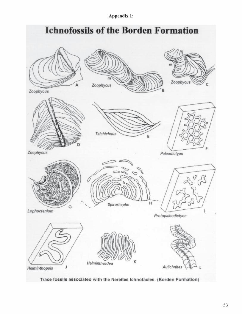
53
Appendix 1:


