upper drainages erosion control improvements
TRANSCRIPT

Upper Drainages Erosion Control Improvements On Highway 9 in Santa Cruz and San Mateo Counties
between Ben Lomond and Highway 35 05-SCr-9 PM 8.5/25.5
05-1G950/0516000005
Initial Studywith Proposed Negative Declaration
Prepared by the State of California Department of Transportation
March 2020

General Information About This Document
Please read this Initial Study. It can be accessed on-line at:
https://dot.ca.gov/caltrans-near-me/district-5
· If you have any concerns about the project, please send your written comments toCaltrans by the deadline. Submit comments via U.S. mail to Caltrans at thefollowing address:Lara BertainaCalifornia Department of Transportation50 Higuera StreetSan Luis Obispo, CA 93401
· Submit comments via email to: [email protected].
· Submit comments or a request for a public hearing by the deadline: July 31, 2020.
After comments are received from the public and reviewing agencies, Caltrans may1) give environmental approval to the proposed project, 2) do additional environmentalstudies, or 3) abandon the project. If the project is given environmental approval andfunding is appropriated, Caltrans could design and build all or part of the project.
For individuals with sensory disabilities, this document is available in Braille, in large print, on audiocassette, or on computer disk. To obtain a copy in one of these alternate formats, please write to or call Caltrans, Attention: Paula Huddleston, 50 Higuera Street, San Luis Obispo, CA 93401; 805-549-3063. You can also call the District 5 Relay Service at (805) 549-3318 (Teletypewriter [TTY]), or the California Relay Service at 1 (800) 735-2929 (TTY), 1 (800) 735-2929 (Voice), or 711.

Upper Drainages Erosion Control Improvements � 1
05-SCr-9 PM 8.5/25.505-1G950/0516000005
Upgrade drainage systems along Highway 9 in Santa Cruz and San Mateo Counties from Scenic Way in Ben Lomond to
0.25 mile north of the Summit Meadows trailhead parking lot
INITIAL STUDY with Proposed Negative Declaration
Submitted Pursuant to: (State) Division 13, California Public Resources Code
THE STATE OF CALIFORNIA Department of Transportation and Responsible Agencies:
California Department of Fish and Wildlife California Transportation Commission
Central Coast Regional Water Quality Control Board Cooperating Agencies:
U.S. Army Corps of Engineers U.S. Fish and Wildlife Service
National Marine Fisheries Service
Upper Drainages Erosion Control Improvements � 2
Proposed Negative Declaration Pursuant to: Division 13, Public Resources Code
Project Description The California Department of Transportation (Caltrans) is proposing to replace or repair drainage systems along Highway 9 within the project limits that have been determined to be deficient. The project would replace and/or reconstruct drainage inlets, install new pipe culverts, fill and abandon old culverts, repair outlets, place rock slope protection, rebuild and lengthen a retaining wall, and repair trail erosion.
Determination This proposed Negative Declaration is included to give notice to interested agencies and the public that it is Caltrans’ intent to adopt a Negative Declaration for this project. This does not mean that Caltrans’ decision on the project is final. This Negative Declaration is subject to change based on comments received by interested agencies and the public.
Caltrans has prepared an Initial Study for this project and, pending public review, expects to determine from this study that the proposed project would not have a significant effect on the environment for the following reasons.
The project would have no adverse effect on: agricultural resources; air quality; cultural resources; hydrology or water quality; land use or planning; mineral resources; population or housing; transportation; utilities; or service systems.
The project would not create an impact from: geology; soils; hazards; or hazardous materials.
The project would have no significant effect on aesthetics; biological resources; public services; recreation; or traffic, nor create a significant effect from noise.
John Luchetta Environmental Office Chief California Department of Transportation
Date

Upper Drainages Erosion Control Improvements � 3
Upper Drainages Erosion Control Improvements � 4
Section 1 Project Description and Background
1.1 Project Title
Upper Drainages Erosion Control Improvements
1.2 Project Location
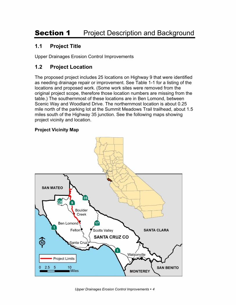
The proposed project includes 25 locations on Highway 9 that were identified as needing drainage repair or improvement. See Table 1-1 for a listing of the locations and proposed work. (Some work sites were removed from the original project scope, therefore those location numbers are missing from the table.) The southernmost of these locations are in Ben Lomond, between Scenic Way and Woodland Drive. The northernmost location is about 0.25 mile north of the parking lot at the Summit Meadows Trail trailhead, about 1.5 miles south of the Highway 35 junction. See the following maps showing project vicinity and location.
Project Vicinity Map

Upper Drainages Erosion Control Improvements � 5
Project Location Map
1.3 Description of Project
The project would replace or modify drainage systems that are deteriorated and/or undersized and that are plugging, overtopping, or flooding and thereby causing erosion. The main component of these drainage systems is the cross-culvert, which is a pipe or other opening that runs under the road from

Upper Drainages Erosion Control Improvements � 6
one side to the other. In some locations, there are other culverts that run longitudinally off the highway shoulder, either as a subsurface pipe or a surface ditch. A few locations have downdrains, which are usually black corrugated plastic pipes that lay on the surface of a slope, directing runoff downhill. Larger culverts usually include a headwall (a short concrete wall securing the opening) at the entrance and occasionally also at the exit, although runoff enters most of the systems via an inlet grate level with the surface of the road.
The project would plug and fill the old pipe culverts; install new, larger pipe culverts; place rock slope protection at outlets where needed; replace substandard inlets; and add minor paving where open ground is causing ex-cessive sediment in the drainage system. An existing retaining wall would be rebuilt and lengthened. The Skyline-to-the-Sea Trail would be repaired where erosion has created a slipout. Guardrail would be repaired where necessary.
Most locations would be constructed via “cut and cover,” a technique that in-volves removing a narrow section of the road surface and excavating to the necessary depth to lay the new pipe, then backfilling the trench to the road surface. Most of this work could be performed from the roadway and Highway 9 would remain open to traffic through one-way traffic control. At four locations (Locations 9, 15, 22, and 25), due to the extreme depth, the new pipes would be jacked through the hill after first drilling a hole from one side to the other. This technique requires equipment to operate off the roadway; large areas of grading would be necessary, and access roads might be needed. Construction access would be limited by establishing environmentally sensitive areas, shown on the plans and delineated on the ground where practical.
Table 1-1 Drainage Improvements
Location Number Site Location Proposed Activity
1
At 8901 Highway 9 in Ben Lomond,
(post mile 9.01)
The existing inlet off the southbound shoulder would be re-placed and connected to a new, second inlet 25 feet away via a new 24-inch pipe. The area around and between the inlets would be paved. All construction vehicles would work from the roadway. An existing 2-inch subsurface drain would be modified to drain into the back side of one of the inlets.
2
Hillside Avenue to the south end of San Lorenzo River Bridge in Ben Lomond,
(post mile 9.33)
The right-turn/bus stop area at Hillside Avenue would be paved and a ditch constructed to direct runoff toward the river. The ditch would convey runoff to a new 36-inch pipe culvert off the roadway shoulder, which would connect to the existing drainage outletting to the river. Existing guardrail would be replaced. All construction vehicles would work from the roadway.
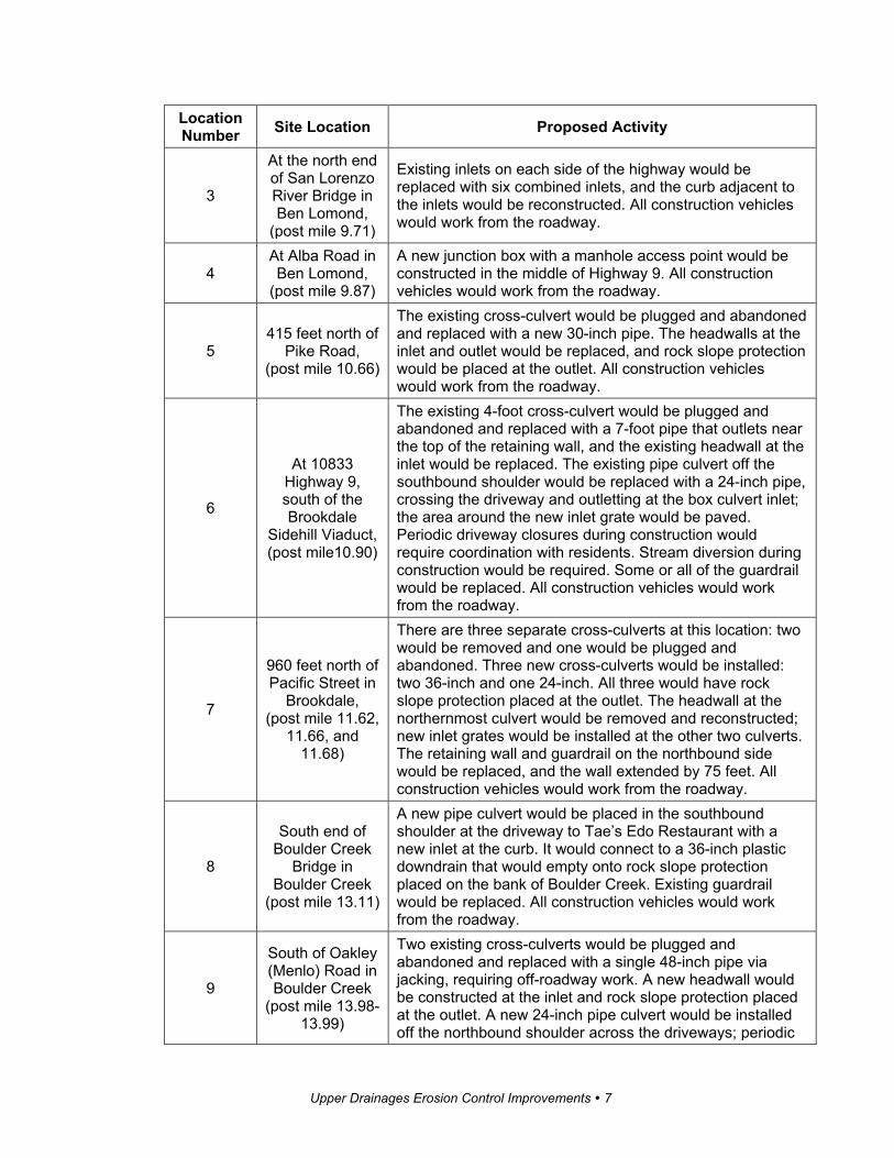
Upper Drainages Erosion Control Improvements � 7
Location Number Site Location Proposed Activity
3
At the north end of San Lorenzo River Bridge in Ben Lomond,
(post mile 9.71)
Existing inlets on each side of the highway would be replaced with six combined inlets, and the curb adjacent to the inlets would be reconstructed. All construction vehicles would work from the roadway.
4 At Alba Road in Ben Lomond,
(post mile 9.87)
A new junction box with a manhole access point would be constructed in the middle of Highway 9. All construction vehicles would work from the roadway.
5 415 feet north of
Pike Road, (post mile 10.66)
The existing cross-culvert would be plugged and abandoned and replaced with a new 30-inch pipe. The headwalls at the inlet and outlet would be replaced, and rock slope protection would be placed at the outlet. All construction vehicles would work from the roadway.
6
At 10833 Highway 9, south of the Brookdale
Sidehill Viaduct, (post mile10.90)
The existing 4-foot cross-culvert would be plugged and abandoned and replaced with a 7-foot pipe that outlets near the top of the retaining wall, and the existing headwall at the inlet would be replaced. The existing pipe culvert off the southbound shoulder would be replaced with a 24-inch pipe, crossing the driveway and outletting at the box culvert inlet; the area around the new inlet grate would be paved. Periodic driveway closures during construction would require coordination with residents. Stream diversion during construction would be required. Some or all of the guardrail would be replaced. All construction vehicles would work from the roadway.
7
960 feet north of Pacific Street in
Brookdale, (post mile 11.62,
11.66, and 11.68)
There are three separate cross-culverts at this location: two would be removed and one would be plugged and abandoned. Three new cross-culverts would be installed: two 36-inch and one 24-inch. All three would have rock slope protection placed at the outlet. The headwall at the northernmost culvert would be removed and reconstructed; new inlet grates would be installed at the other two culverts. The retaining wall and guardrail on the northbound side would be replaced, and the wall extended by 75 feet. All construction vehicles would work from the roadway.
8
South end of Boulder Creek
Bridge in Boulder Creek
(post mile 13.11)
A new pipe culvert would be placed in the southbound shoulder at the driveway to Tae’s Edo Restaurant with a new inlet at the curb. It would connect to a 36-inch plastic downdrain that would empty onto rock slope protection placed on the bank of Boulder Creek. Existing guardrail would be replaced. All construction vehicles would work from the roadway.
9
South of Oakley (Menlo) Road in Boulder Creek
(post mile 13.98-13.99)
Two existing cross-culverts would be plugged and abandoned and replaced with a single 48-inch pipe via jacking, requiring off-roadway work. A new headwall would be constructed at the inlet and rock slope protection placed at the outlet. A new 24-inch pipe culvert would be installed off the northbound shoulder across the driveways; periodic

Upper Drainages Erosion Control Improvements � 8
Location Number Site Location Proposed Activity
driveway closures during construction would require coordination with residents. A new inlet would be constructed and rock slope protection placed at the outlet. The existing overside drain, located on the west side of Highway 9, would be reconstructed with an asphalt-concrete dike inlet, and a 24-inch downdrain would be directed down the slope to the rock slope protection at the outlet of the cross-culvert.
10 At Cresta Drive, Boulder Creek
(post mile 14.04)
The existing cross-culvert would be removed and replaced with a 24-inch pipe. The outlet area of the cross-culvert would be reconstructed and the adjacent area paved. The existing pipe culvert running along the northbound shoulder at Cresta Drive would be removed and replaced with a 24-inch pipe connecting to the cross-culvert, and a new inlet installed at the connection. The area off the northbound shoulder south of Cresta Drive would be graded and paved. All construction vehicles would work from the roadway.
11
180 feet north of Juanita Road in Boulder Creek
(post mile 14.24)
The existing cross-culvert would be removed and replaced with a 24-inch pipe. Rock slope protection would be placed at the outlet, and the existing headwall would be removed and replaced. All construction vehicles would work from the roadway.
13 At Lorenzo Lane in Boulder Creek (post mile 15.05)
The existing cross-culvert would be removed and replaced with a 24-inch pipe, and rock slope protection placed at the outlet. The existing headwall would be removed, and dual inlet grates installed. The recessed area off the northbound shoulder would be graded to create a ditch to direct runoff, and some or all of the guardrail replaced. All construction vehicles would work from the roadway.
14 At the YMCA
Camp Campbell (post mile 15.98)
The existing cross-culvert would be removed and replaced with a 24-inch pipe. Grading would be required at the inlet. All construction vehicles would work from the roadway.
15
At 18218 Highway 9 near
Stapp Road (post mile 17.89)
The existing 5.5-foot cross-culvert would be replaced with a 10-foot box culvert via jacking, which would require off-road work, and rock slope protection placed at the outlet. Stream diversion during construction would be required.
16 At Sylvan
Avenue (post mile 18.41)
The existing cross-culvert would be removed and replaced with two 36-inch pipes; all other pipe culverts would be plugged and filled. A new headwall and trash grate would be constructed at the inlet, with rock slope protection at the outlet. A new 36-inch pipe culvert would be installed longitudinally in the highway shoulder at Sylvan Avenue. A new 24-inch pipe downdrain would be installed at the northbound shoulder and drain to the rock slope protection. Periodic closures of Sylvan Avenue would be required. All construction vehicles would work from the roadway and the pullout at Sylvan Avenue.

Upper Drainages Erosion Control Improvements � 9
Location Number Site Location Proposed Activity
17
At Celia Avenue/ McGaffigan Mill
Road (post mile 18.48)
Construct a new drainage system to include: a new inlet on each side of Celia Avenue connected by a pipe culvert; a cross-culvert under the highway; a service inlet in the southbound highway shoulder; and a pipe culvert running northward along Highway 9 for 246 feet and outletting onto rock slope protection. All pipe culverts would be 24 inches in diameter. The ground around the service inlet would be paved. Some or all of the guardrail would be replaced. All construction vehicles would work from Celia Avenue and Highway 9; periodic closures of Celia Avenue would be required. All construction vehicles would work from the roadways and driveways.
18
0.4 mile north of McGaffigan Mill
Road (post mile 18.86)
The existing cross-culvert and downdrain would be replaced with new 30-inch components using the existing junction box; rock slope protection would be placed at the outlet, and a new headwall constructed at the inlet. The existing overside drain would also be replaced with an asphalt-concrete ditch running down the slope to the new rock slope protection. The area off the northbound shoulder would be paved to help direct runoff and reduce sediment. All construction vehicles would work from the roadway.
19
0.5 mile north of McGaffigan Mill
Road (post mile 18.97)
The existing downdrain would be replaced with new 24-inch plastic pipe, and rock slope protection would be placed at the outlet. All construction vehicles would work from the roadway.
21
0.75 mile south of northern
Route 236/9 intersection
(post mile 20.09)
The existing cross-culvert would be replaced with new 24-inch pipe, and the existing headwall at the inlet replaced with a new headwall. Some grading and fill would be required. All construction vehicles would work from the roadway.
22
0.20 mile north of northern
Route 236/9 intersection
(post mile 21.02)
The existing dual cross-culvert system would be plugged and abandoned and replaced with a new, single 36-inch cross-culvert via jacking, requiring off-road work. The headwall at the inlet would be replaced, and rock slope protection would be placed at the outlet.
23
0.22 mile south of Beekhius
Road (post mile 23.01)
Construct a downdrain by connecting 24-inch plastic pipe to the outlet of the existing cross-culvert and running it downhill for up to 100 feet. Rock slope protection would be placed at the outlet. Construction access off the highway could be required.
24 350 feet north of Beekhius Road
(post mile 23.31)
Repair slipout on Caltrans right-of-way on the Skyline-to-the-Sea Trail caused by erosion from the old culvert outlet upslope. (This culvert has since been plugged, and a new one with rock slope protection at the outlet constructed to the south.)
25 0.28 mile north
of Tin Can Ranch Road,
The existing 18-inch cross-culvert would be plugged and abandoned and replaced with new 36-inch pipe via jacking, which would require off-road work, situated to avoid impacts

Upper Drainages Erosion Control Improvements � 10
Location Number Site Location Proposed Activity
San Mateo County
(post mile 23.99)
to trees. A new headwall would be constructed at the inlet, and rock slope protection placed at the outlet.
26
300 feet south of Summit
Meadows Trail parking lot
(post mile 25.15)
The existing cross-culvert would be removed and replaced with new 24-inch pipe with new inlet and rock slope protection placed at the outlet. Some grading would be necessary at the inlet. All construction vehicles would work from the roadway.
27
0.25 mile north of Summit
Meadows Trail parking lot
(post mile 25.48)
The existing cross-culvert would be removed and replaced with new 24-inch pipe with new inlet and rock slope protection placed at the outlet. All construction vehicles would work from the roadway.
1.4 Surrounding Land Uses and Setting
Highway 9 winds along the slopes above the San Lorenzo Valley at the north-ern reach of the Santa Lucia Range. The project is in a heavily wooded, semi-rural area, with individual residences and small neighborhoods scattered along the immediate highway vicinity, including three small urban hubs: Felton, Ben Lomond, and Boulder Creek.
Highway 9 is the main transportation route to and through the area for both passenger and commercial vehicles. Due to the limited access, traffic on Highway 9 can be heavy but flowing during peak hours. Traffic volumes at the southern portion of the route are substantially higher than at the northern por-tion due to the City of Santa Cruz, where Highway 9 originates, being a major commercial and employment source. This causes peak traffic to be heavily one-directional, correlating with the morning and evening peak hours.
Within the project limits, traffic volumes are heaviest between Location 1 (near Scenic Way) and Location 13 (at Riverside Drive), dropping dramati-cally as one moves northward. Most of the drainage locations are in sparsely developed, heavily wooded stretches of the highway, particularly those in the northern half of the project limits.
1.5 Other Public Agencies Whose Approval is Required
Table 1-2 lists the agencies that would issue approvals or permits for the project that could affect the minimization or mitigation measures, the final determination, or project funding.

Upper Drainages Erosion Control Improvements � 11
Table 1-2 Permitting and Approving Agencies
Agency Permit/Approval Status
California Department of Fish and Wildlife
Section 1602 Streambed Alteration Agreement for construction within creek channels
Acquired during final design of the project.
U.S. Army Corps of Engineers
Section 404 nationwide permit for construction within creek channels
Acquired during final design of the project.
Central Coast Regional Water Quality Control Board
Section 401 Certification for construction within creek channels
Acquired during final design of the project.
U.S. Fish and Wildlife Service
Section 7 programmatic consultation and Biological Opinion for the California red-legged frog
Completed.
National Marine Fisheries Service
Section 7 informal consultation and letter of concurrence for Central California Coast steelhead trout, coho salmon, critical habitat, and essential fish habitat
In process.
California Transportation Commission Funding approval
Acquired prior to advertising project for contract bids.

Upper Drainages Erosion Control Improvements � 12
Section 2 CEQA Environmental Checklist
2.1 CEQA Checklist
This checklist identifies physical, biological, social, and economic factors that might be affected by the proposed project. Potential impact determinations include Significant and Unavoidable Impact, Less Than Significant With Mitigation Incorporated, Less Than Significant Impact, and No Impact. In many cases, background studies performed in connection with a project will indicate that there are no impacts to a particular resource. A No Impact answer reflects this determination. The words “significant” and “significance” used throughout the following checklist are related to impacts under the California Environmental Quality Act (known as CEQA), not the National Environmental Policy Act (known as NEPA). The questions in this CEQA checklist are intended to encourage the thoughtful assessment of impacts and do not represent thresholds of significance.
Project features, which can include both design elements of the project and standardized measures that are applied to all or most Caltrans projects such as Best Management Practices and measures included in the Standard Plans and Specifications or as Standard Special Provisions, are considered to be an integral part of the project and have been considered prior to any significance determinations documented below.
2.1.1 Aesthetics
CEQA Significance Determinations for Aesthetics Except as provided in Public Resources Code Section 21099, would the project:
a) Have a substantial adverse effect on a scenic vista?
No Impact—There are no scenic vistas at any of the drainage locations.
b) Substantially damage scenic resources, including, but not limited to, trees, rock outcroppings, and historic buildings within a state scenic highway?
No Impact—Highway 9 is not a state scenic highway.
c) In non-urbanized areas, substantially degrade the existing visual character or quality of public views of the site and its surroundings? (Public views are those that are experienced from a publicly accessible vantage point.) If the project is in an urbanized area, would the project conflict with applicable zoning and other regulations governing scenic quality?
Less Than Significant Impact—The facilities proposed for repair are mostly downslope of the highway or in heavily vegetated areas and therefore out of

Upper Drainages Erosion Control Improvements � 13
view. Most facilities at road level are unobtrusive, such as inlets or headwalls. Some locations would include minimal paved area next to the road. The largest amount of paving would be at Location 2, where Caltrans is proposing to pave the turnout at Hillside Avenue and construct a paved ditch to convey runoff to a new pipe culvert. This is in a more developed area, and the additional hardscape would not be out of character. Some vegetation clearing would occur at most of the work locations to allow room for construction. These areas would revegetate naturally; replanting would be included in the project where appropriate. Newer guardrail on the new retaining wall at Location 7 might temporarily appear out of character for the corridor, but natural weathering would reduce its prominence.
d) Create a new source of substantial light or glare which would adversely affect day or nighttime views in the area?
No Impact— There are no components proposed that would create glare or reflections. There are no light sources proposed.
2.1.2 Agriculture and Forest Resources
CEQA Significance Determinations for Agriculture and Forest Resources In determining whether impacts to agricultural resources are significant envi-ronmental effects, lead agencies may refer to the California Agricultural Land Evaluation and Site Assessment Model (1997) prepared by the California De-partment of Conservation as an optional model to use in assessing impacts on agriculture and farmland. In determining whether impacts to forest re-sources, including timberland, are significant environmental effects, lead agencies may refer to information compiled by the California Department of Forestry and Fire Protection regarding the state’s inventory of forest land, in-cluding the Forest and Range Assessment Project and the Forest Legacy Assessment Project; and the forest carbon measurement methodology pro-vided in Forest Protocols adopted by the California Air Resources Board.
Would the project:
a) Convert Prime Farmland, Unique Farmland, or Farmland of Statewide Importance (Farmland), as shown on the maps prepared pursuant to the Farmland Mapping and Monitoring Program of the California Resources Agency, to non-agricultural use?
No Impact—There is no farmland in the project area.
b) Conflict with existing zoning for agricultural use, or a Williamson Act contract?

Upper Drainages Erosion Control Improvements � 14
No Impact—There is no zoning for agriculture or Williamson Act properties in the project area.
c) Conflict with existing zoning for, or cause rezoning of, forest land (as defined in Public Resources Code section 12220(g)), timberland (as defined by Public Resources Code section 4526), or timberland zoned Timberland Production (as defined by Government Code section 51104(g))?
No Impact—The repair of drainage facilities has no effect on zoning or land use.
d) Result in the loss of forest land or conversion of forest land to non-forest use?
No Impact—The project would temporarily clear understory vegetation in small, localized areas, but no trees would be removed and no areas would be converted to another use.
e) Involve other changes in the existing environment which, due to their location or nature, could result in conversion of Farmland to non-agricultural use or conversion of forest land to non-forest use?
No Impact—The project would not result in the conversion of any land use.
2.1.3 Air Quality
CEQA Significance Determinations for Air Quality Where available, the significance criteria established by the applicable air quality management district or air pollution control district may be relied upon to make the following determinations.
Would the project:
a) Conflict with or obstruct implementation of the applicable air quality plan?
No Impact—The completed project would not be associated with air quality issues. Construction emissions do not violate the Monterey Bay Unified Air Pollution Control District’s Air Quality Management Plan, and disturbed areas will be well within the daily allowance.
b) Result in a cumulatively considerable net increase of any criteria pollutant for which the project region is non-attainment under an applicable federal or state ambient air quality standard?
No Impact—The project is within the North Central Coast Air Basin, which is non-attainment (one or more violations in the past three years) for state levels of ozone and small particulate (dust). The completed project would result in no increase in these pollutants. Construction activity produces ozone

Upper Drainages Erosion Control Improvements � 15
precursors and dust but, due to the small areas of disturbance, these emissions are expected to be within allowable thresholds and would not be significant contributors to a cumulative increase.
c) Expose sensitive receptors to substantial pollutant concentrations?
No Impact—Pollutant emissions would occur only during construction, and these would be minimal due to the limited work involved at each location.
d) Result in other emissions (such as those leading to odors) adversely affecting a substantial number of people?
No Impact—Emissions would occur only during construction and, because of the low population density, would affect few individuals, if any.
2.1.4 Biological Resources
CEQA Significance Determinations for Biological Resources Would the project:
a) Have a substantial adverse effect, either directly or through habitat modifications, on any species identified as a candidate, sensitive, or special status species in local or regional plans, policies, or regulations, or by the California Department of Fish and Wildlife or U.S. Fish and Wildlife Service?
Less Than Significant Impact—The San Lorenzo River and other streams within its watershed are designated critical habitat for the central California coast steelhead trout and central California coast coho salmon, as well as being essential fish habitat for the latter. These designations are present at Locations 2, 8, and 19, but they will not be affected by construction activities in the stream channels. Vegetation removal would temporarily impact designated critical habitat, but this is outweighed by the overall long-term benefits of the project to reduce sedimentation. The project would have no adverse impacts on essential fish habitat for the coho salmon.
Several of the work locations contain habitat that could support these state and/or federally protected species:
· California red-legged frog: federally threatened; state species of special concern
· Foothill yellow-legged frog: state species of special concern and candidate for state listing
· Western pond turtle: state species of special concern
· Santa Cruz black salamander: state species of special concern
· California giant salamander: state species of special concern

Upper Drainages Erosion Control Improvements � 16
· Central California coast steelhead: federally threatened
· Central California coast coho salmon: federally endangered; state endangered
There are no known occurrences of the California red-legged frog, foothill yellow-legged frog, western pond turtle, Santa Cruz black salamander, or California giant salamander in the biological study area. None of these species were seen during field reviews, but they have been presumed present at Locations 2, 6, 7, 8, 9, 15, 16, 17, 19, and 21 because suitable habitat is present. Appropriate measures from the Programmatic Biological Opinion for the California red-legged frog would be incorporated into the project to prevent inadvertent impacts, including but not limited to pre-construction surveys; removal of individuals found; staff training; exclusionary methods; regrading to original contours; and replanting. These practices would also protect the other aquatic species that could be present during construction. No steelhead trout or coho salmon are expected to be present where stream diversion could occur.
b) Have a substantial adverse effect on any riparian habitat or other sensitive natural community identified in local or regional plans, policies, regulations or by the California Department of Fish and Wildlife or U.S. Fish and Wildlife Service?
Less Than Significant Impact—The project would create both temporary and permanent impacts to riparian and stream channel habitat where work is required within a creek (Locations 6, 7, 9, 15, 16, and 21).
· Total stream channel impacts (square feet): temporary 1,930; permanent 479
· Total riparian habitat impacts (square feet): temporary 6,272; permanent 841
The project would also involve vegetation removal in construction areas and where access roads were cleared. This could include removing trees in spot locations. To limit the areas of disturbance during construction, environmentally sensitive areas would be shown on the plans and delineated on the ground where practical. Construction within stream channels would be scheduled for the driest seasons or as specified in applicable permits, and erosion control devices would be used to keep material out of the channels. If stream diversion is necessary, stream contours would be regraded to their original condition prior to equipment removal. Replanting would be done at a 1 to 1 ratio for temporary impacts and a 3 to 1 ratio for permanent impacts, including a one-year plant establishment period.
To control invasive species, measures such as importing fill from a source known to be free of invasive plant species and/or removing vegetation and

Upper Drainages Erosion Control Improvements � 17
the top 6 inches of soil if necessary from weedy locations and taking it to a landfill would be included in the contract.
c) Have a substantial adverse effect on state or federally protected wetlands (including, but not limited to, marsh, vernal pool, coastal, etc.) through direct removal, filling, hydrological interruption, or other means?
No Impact—No state or federally protected wetlands were identified within the project limits.
d) Interfere substantially with the movement of any native resident or migratory fish or wildlife species or with established native resident or migratory wildlife corridors, or impede the use of native wildlife nursery sites?
No Impact—The project does not propose construction of any land obstacles. No barriers to fish passage were identified at any of the project locations.
e) Conflict with any local policies or ordinances protecting biological resources, such as a tree preservation policy or ordinance?
No Impact—The project is not known to conflict with any local policies or ordinances.
f) Conflict with the provisions of an adopted Habitat Conservation Plan, Natural Community Conservation Plan, or other approved local, regional, or state habitat conservation plan?
No Impact—There are no conservation plans applicable to this location.
2.1.5 Cultural Resources
CEQA Significance Determinations for Cultural Resources Would the project:
a) Cause a substantial adverse change in the significance of a historical resource pursuant to Section15064.5?
No Impact—All historical resources would be avoided.
b) Cause a substantial adverse change in the significance of an archaeological resource pursuant to Section15064.5?
No Impact—All archaeological resources would be avoided.
c) Disturb any human remains, including those interred outside of dedicated cemeteries?
Upper Drainages Erosion Control Improvements � 18
No Impact—Studies indicate there should be no expectation of human remains during construction. If human remains were discovered, all construction activities would cease until the remains can be evaluated.
2.1.6 Energy
CEQA Significance Determinations for Energy Would the project:
a) Result in potentially significant environmental impact due to wasteful, inefficient, or unnecessary consumption of energy resources, during project construction or operation?
No Impact—Other than the energy necessary for construction of the project, there would be no energy use by the project.
b) Conflict with or obstruct a state or local plan for renewable energy or energy efficiency?
No Impact—The project is not associated with energy plans.
2.1.7 Geology and Soils
CEQA Significance Determinations for Geology and Soils Would the project:
a) Directly or indirectly cause potential substantial adverse effects, including the risk of loss, injury, or death involving:
i) Rupture of a known earthquake fault, as delineated on the most recent Alquist-Priolo Earthquake Fault Zoning Map issued by the State Geologist for the area or based on other substantial evidence of a known fault? (Refer to Division of Mines and Geology Special Publication 42.)
No Impact—There are no known active faults in the region.
ii) Strong seismic ground shaking?
No Impact—See response to question a) i) above.
iii) Seismic-related ground failure, including liquefaction?
No Impact—See response to question a) i) above.
iv) Landslides?
No Impact—Although the area is prone to landslides, the project would not substantially contribute to ground instability, but rather is intended to reduce erosion and flooding and thus improve soil stability in the vicinity.

Upper Drainages Erosion Control Improvements � 19
b) Result in substantial soil erosion or the loss of topsoil?
No Impact—The project is intended to reduce erosion and topsoil loss.
c) Be located on a geologic unit or soil that is unstable, or that would become unstable as a result of the project, and potentially result in on- or off-site landslide, lateral spreading, subsidence, liquefaction or collapse?
No Impact—Many of the culvert locations are near highly erodible soil and consequently there has been some surface ground movement to date. The project is intended to reduce instability by reducing erosion and flooding.
d) Be located on expansive soil, as defined in Table 18-1-B of the Uniform Building Code (1994), creating substantial direct or indirect risks to life or property?
No Impact—The project locations are not on expansive soil.
e) Have soils incapable of adequately supporting the use of septic tanks or alternative waste water disposal systems where sewers are not available for the disposal of waste water?
No Impact—No facilities of this kind are included in the project.
f) Directly or indirectly destroy a unique paleontological resource or site or unique geologic feature?
No Impact—There are no known resources of these types within the project limits.
2.1.8 Greenhouse Gas Emissions
CEQA Significance Determinations for Greenhouse Gas Emissions Would the project:
a) Generate greenhouse gas emissions, either directly or indirectly, that may have a significant impact on the environment?
No Impact—While construction equipment would contribute to greenhouse gas emissions, the impact would be highly localized and of a short duration. The completed project would have no effect on greenhouse gas emissions.
b) Conflict with an applicable plan, policy or regulation adopted for the purpose of reducing the emissions of greenhouse gases?
No Impact—The project is not in conflict with any plan, policy, or regulation.

Upper Drainages Erosion Control Improvements � 20
2.1.9 Hazards and Hazardous Materials
CEQA Significance Determinations for Hazards and Hazardous Materials Would the project:
a) Create a significant hazard to the public or the environment through the routine transport, use, or disposal of hazardous materials?
No Impact—The project is not associated with hazardous materials.
b) Create a significant hazard to the public or the environment through reasonably foreseeable upset and accident conditions involving the release of hazardous materials into the environment?
No Impact—The project would modify the existing drainages but not change the likelihood or severity of an accident involving hazardous substances.
c) Emit hazardous emissions or handle hazardous or acutely hazardous materials, substances, or waste within one-quarter mile of an existing or proposed school?
No Impact—Location 2 is less than 500 feet from Saint Andrew Preschool. At this location, Caltrans is proposing to pave the bus stop at Hillside Avenue and construct a paved ditch to convey runoff to a new pipe culvert within the roadway shoulder, which will connect to the existing drainage that outlets to the San Lorenzo River. The existing guardrail would also be replaced.
Location 8 is within one-quarter mile of Boulder Creek Elementary School. At this location, Caltrans is proposing to replace the drainage inlet in the Liberty Bank driveway and install a new pipe culvert under the road shoulder, eventually outletting onto rock slope protection on the bank of Boulder Creek.
The project, once completed, would not create any hazardous substances. Construction activities would emit fumes and involve materials that, while not considered hazardous when used correctly, could be irritants to sensitive individuals or be damaging to the environment in large quantities. Adherence to Caltrans standard construction specifications and regulatory safety measures would preclude adverse impacts to the public or the environment.
d) Be located on a site which is included on a list of hazardous materials sites compiled pursuant to Government Code Section 65962.5 and, as a result, would it create a significant hazard to the public or the environment?
No Impact—None of the project locations are on or near a hazardous materials site.
e) For a project located within an airport land use plan or, where such a plan has not been adopted, within two miles of a public airport or public use

Upper Drainages Erosion Control Improvements � 21
airport, would the project result in a safety hazard or excessive noise for people residing or working in the project area?
No Impact—The project locations are not within an airport land use plan nor within 2 miles of an airport. The nearest airport, Bonny Doon Village airport, is a private airport approximately 2.25 miles from Location 1, the nearest project location.
f) Impair implementation of or physically interfere with an adopted emergency response plan or emergency evacuation plan?
No Impact—There is no formal emergency response or evacuation plan for Highway 9, but the completed project would improve highway reliability.
g) Expose people or structures, either directly or indirectly, to a significant risk of loss, injury or death involving wildland fires?
No Impact—Highway 9 is not within a generalized critical fire hazard area; the project would not alter the fire risk in the area.
2.1.10 Hydrology and Water Quality
CEQA Significance Determinations for Hydrology and Water Quality Would the project:
a) Violate any water quality standards or waste discharge requirements or otherwise substantially degrade surface or ground water quality?
No Impact—The project is intended to improve surface water quality by reducing sedimentation.
b) Substantially decrease groundwater supplies or interfere substantially with groundwater recharge such that the project may impede sustainable groundwater management of the basin?
No Impact—The project would manage surface water only.
c) Substantially alter the existing drainage pattern of the site or area, including through the alteration of the course of a stream or river or through the addition of impervious surfaces, in a manner that would:
i) Result in substantial erosion or siltation on- or off-site?
No Impact—Some of the new pipe culverts would outlet in a different location from the existing outlets and thereby introduce surface runoff where it had not previously existed. Each outlet, however, would have adequate attenuation for the quantity of water expected from that culvert and thus eliminate or

Upper Drainages Erosion Control Improvements � 22
greatly reduce erosion and siltation such that it would not adversely affect water quality.
ii) Substantially increase the rate or amount of surface runoff in a manner which would result in flooding on- or off-site?
No Impact—The new culverts would convey the same quantity of water as the existing systems. The rate in some locations would lessen because the new culverts would be larger.
iii) Create or contribute runoff water which would exceed the capacity of existing or planned stormwater drainage systems or provide substantial additional sources of polluted runoff?
No Impact—The new drainage systems are being designed to manage anticipated runoff quantities. In some locations, that means a larger culvert would be used.
iv) Impede or redirect flood flows?
No Impact—Location 2 (the bus stop at Hillside Avenue) and Location 3 (at the San Lorenzo River Bridge by the Quality Inn and Suites) are within a designated Federal Emergency Management Agency special flood hazard area. Both locations would help reduce surface flooding by collecting runoff and directing it toward the river.
d) In flood hazard, tsunami, or seiche zones, risk release of pollutants due to project inundation?
No Impact—Neither of the two locations within a flood hazard area [identified in question c) iv above] would contain any pollutants.
e) Conflict with or obstruct implementation of a water quality control plan or sustainable groundwater management plan?
No Impact—The project is intended to improve water quality by reducing erosion and sedimentation; it will have no impact on groundwater.
2.1.11 Land Use and Planning
CEQA Significance Determinations for Land Use and Planning Would the project:
a) Physically divide an established community?
No Impact—There would be no change in the spatial relationship of the highway to residences or businesses.

Upper Drainages Erosion Control Improvements � 23
b) Cause a significant environmental impact due to a conflict with any land use plan, policy, or regulation adopted for the purpose of avoiding or mitigating an environmental effect?
No Impact—The project would not conflict with any plan, policy, or regulation.
2.1.12 Mineral Resources
CEQA Significance Determinations for Mineral Resources Would the project:
a) Result in the loss of availability of a known mineral resource that would be of value to the region and the residents of the state?
No Impact—There is no known mineral resource at the drainage facility locations.
b) Result in the loss of availability of a locally important mineral resource recovery site delineated on a local general plan, specific plan or other land use plan?
No Impact—There is no known mineral resource at the drainage facility locations.
2.1.13 Noise
CEQA Significance Determinations for Noise Would the project result in:
a) Generation of a substantial temporary or permanent increase in ambient noise levels in the vicinity of the project in excess of standards established in the local general plan or noise ordinance, or applicable standards of other agencies?
Less Than Significant Impact—The project would create no permanent noise impacts. Construction activities would produce loud noises that would likely be disruptive to nearby receptors, particularly if they occur at night. These occurrences would be temporary and highly localized. The Santa Cruz County noise ordinance does not have an exception for construction activities, therefore the project could be in violation of local regulations, which prohibit “offensive noise” as defined in Section 8.30.010. Because of their limited nature, the anticipated impacts from construction noise, while substantial, are not considered significant. The Resident Engineer would work with local residents and businesses to the extent practicable to limit adverse impacts from construction noise.
b) Generation of excessive groundborne vibration or groundborne noise levels?

Upper Drainages Erosion Control Improvements � 24
Less Than Significant—Construction work would involve substantial ground disturbance by mechanical means, which could generate minor groundborne vibration and noise to receptors very close to the work. The effects would be temporary and not require any precautions.
c) For a project located within the vicinity of a private airstrip or an airport land use plan or, where such a plan has not been adopted, within two miles of a public airport or public use airport, would the project expose people residing or working in the project area to excessive noise levels?
No Impact—The project is not within the vicinity of an airstrip or airport land use plan.
2.1.14 Population and Housing
CEQA Significance Determinations for Population and Housing Would the project:
a) Induce substantial unplanned population growth in an area, either directly (for example, by proposing new homes and businesses) or indirectly (for example, through extension of roads or other infrastructure)?
No Impact—No aspect of the project would affect growth.
b) Displace substantial numbers of existing people or housing, necessitating the construction of replacement housing elsewhere?
No Impact—There are no displacements associated with the project.
2.1.15 Public Services
CEQA Significance Determinations for Public Services a) Would the project result in substantial adverse physical impacts associated with the provision of new or physically altered governmental facilities, need for new or physically altered governmental facilities, the construction of which could cause significant environmental impacts, in order to maintain acceptable service ratios, response times or other performance objectives for any of the public services:
Fire protection?
No Impact—There are no government facilities of this nature associated with the project.
Police protection?
No Impact—There are no government facilities of this nature associated with the project.

Upper Drainages Erosion Control Improvements � 25
Schools?
No Impact—There are no government facilities of this nature associated with the project.
Parks?
Less Than Significant Impact—The project includes repair of an eroded portion of the Skyline-to-the-Sea Trail within Castle Rock State Park. Erosion occurred due to a deficient culvert system that has since been plugged and a new, replacement pipe culvert was installed nearby. The outlet of the new culvert is higher up the slope, and rock slope protection was placed at the outlet. This should disperse the water’s energy and flow so that it does not cause additional erosion to the trail in the future.
Other public facilities?
No Impact—There are no government facilities of any other nature associated with the project.
2.1.16 Recreation
CEQA Significance Determinations for Recreation a) Would the project increase the use of existing neighborhood and regional parks or other recreational facilities such that substantial physical deterioration of the facility would occur or be accelerated?
No Impact—The project would not increase the use of parks or recreational facilities.
b) Does the project include recreational facilities or require the construction or expansion of recreational facilities which might have an adverse physical effect on the environment?
No Impact—See response in 2.1.15 above under Public Services, Parks. The repair work would be limited to the trail itself and not create any environmental impacts.
2.1.17 Transportation
CEQA Significance Determinations for Transportation Would the project:
a) Conflict with a program plan, ordinance or policy addressing the circulation system, including transit, roadway, bicycle and pedestrian facilities?
Upper Drainages Erosion Control Improvements � 26
No Impact—Once completed, the project would have no adverse impact on the circulation system. During construction, there would be delays to traffic due to temporary closures and/or one-way traffic control.
b) Conflict with or be inconsistent with CEQA Guidelines Section 15064.3, subdivision (b)?
No Impact— The project would not change transportation patterns and therefore would not contribute in any way to vehicle miles traveled
c) Substantially increase hazards due to a geometric design feature (e.g., sharp curves or dangerous intersections) or incompatible uses (e.g., farm equipment)?
No Impact—The project improves some of the geometric features of the existing drainage facilities by removing outdated structures (such as headwalls) from the path of errant vehicles. Otherwise, there are no changes to existing design features.
d) Result in inadequate emergency access?
Less Than Significant Impact—The completed project would improve highway reliability by reducing erosion and flooding. There would be traffic delays during construction due to one-way traffic control. Traffic stops and detours could delay emergency vehicles. Emergency services are notified of potential delays and detours.
2.1.18 Tribal Cultural Resources
CEQA Significance Determinations for Tribal Cultural Resources Would the project cause a substantial adverse change in the significance of a tribal cultural resource, defined in Public Resources Code section 21074 as either a site, feature, place, cultural landscape that is geographically defined in terms of the size and scope of the landscape, sacred place, or object with cultural value to a California Native American tribe, and that is:
a) Listed or eligible for listing in the California Register of Historical Resources, or in a local register of historical resources as defined in Public Resources Code Section 5020.1(k), or
No Impact—There are no tribal cultural resources within the vicinity of the drainage facilities, and therefore there is no effect.
b) A resource determined by the lead agency, in its discretion and supported by substantial evidence, to be significant pursuant to criteria set forth in subdivision (c) of Public Resources Code Section 5024.1. In applying the criteria set forth in subdivision (c) of Public Resource Code Section 5024.1,

Upper Drainages Erosion Control Improvements � 27
the lead agency shall consider the significance of the resource to a California Native American tribe.
No Impact—There are no tribal cultural resources within the vicinity of the drainage facilities, and therefore there is no effect.
2.1.19 Utilities and Service Systems
CEQA Significance Determinations for Utilities and Service Systems Would the project:
a) Require or result in the relocation or construction of new or expanded water, wastewater treatment or storm water drainage, electric power, natural gas, or telecommunications facilities, the construction or relocation of which could cause significant environmental effects?
No Impact—The project objective is to modify existing drainage facilities, but studies have indicated there would be no significant effects.
b) Have sufficient water supplies available to serve the project and reasonably foreseeable future development during normal, dry and multiple dry years?
No Impact—No water supplies are required.
c) Result in a determination by the wastewater treatment provider which serves or may serve the project that it has adequate capacity to serve the project’s projected demand in addition to the provider’s existing commitments?
No Impact—No wastewater treatment is required.
d) Generate solid waste in excess of state or local standards, or in excess of the capacity of local infrastructure, or otherwise impair the attainment of solid waste reduction goals?
No Impact—The project would not generate solid waste.
e) Comply with federal, state, and local management and reduction statutes and regulations related to solid waste?
No Impact—Solid waste regulations are not applicable to this project.
2.1.20 Wildfire
CEQA Significance Determinations for Wildfire If located in or near state responsibility areas or lands classified as very high fire hazard severity zones, would the project:

Upper Drainages Erosion Control Improvements � 28
a) Substantially impair an adopted emergency response plan or emergency evacuation plan?
No Impact—The project is within areas rated as either “moderate” or “high” within the state responsibility area, but is adjacent to areas rated “very high.” There is no formal emergency response or evacuation plan for Highway 9, but the completed project would improve highway reliability.
b) Due to slope, prevailing winds, and other factors, exacerbate wildfire risks, and thereby expose project occupants to pollutant concentrations from a wildfire or the uncontrolled spread of a wildfire?
No Impact—The project does not include any unusually flammable components that would exacerbate wildfire risk.
c) Require the installation or maintenance of associated infrastructure (such as roads, fuel breaks, emergency water sources, power lines or other utilities) that may exacerbate fire risk or that may result in temporary or ongoing impacts to the environment?
No Impact—The project does not include these items.
d) Expose people or structures to significant risks, including downslope or downstream flooding or landslides, as a result of runoff, post-fire slope instability, or drainage changes?
No Impact—The project is intended to improve drainage and as a result will reduce flooding and erosion. All culverts that outlet onto a slope would receive appropriate energy dissipators to control runoff and reduce erosion that could lead to landslides.
2.1.21 Mandatory Findings of Significance
CEQA Significance Determinations for Mandatory Findings of Significance a) Does the project have the potential to substantially degrade the quality of the environment, substantially reduce the habitat of a fish or wildlife species, cause a fish or wildlife population to drop below self-sustaining levels, threaten to eliminate a plant or animal community, substantially reduce the number or restrict the range of a rare or endangered plant or animal or eliminate important examples of the major periods of California history or prehistory?
No Impact—The project would create minor disturbance to the environment during construction, but regrowth would quickly return the locations to their normal state. Furthermore, the project would help stabilize the area
Upper Drainages Erosion Control Improvements � 29
addressed by each drainage facility by reducing erosion and controlling drainage flow.
b) Does the project have impacts that are individually limited, but cumulatively considerable? (“Cumulatively considerable” means that the incremental effects of a project are considerable when viewed in connection with the effects of past projects, the effects of other current projects, and the effects of probable future projects.)
No Impact—Few projects occur in the project vicinity due to the rural and mountainous location. The project would have no lasting adverse impacts on the environment. The majority of adverse environmental impacts along the highway corridor are the result of human habitation and associated activity.
c) Does the project have environmental effects which will cause substantial adverse effects on human beings, either directly or indirectly?
No Impact—Studies have indicated there would be no substantial adverse effects as a result of construction and operation of the drainage facilities.
Upper Drainages Erosion Control Improvements � 30
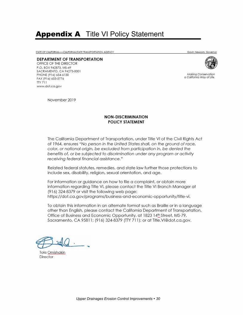
Appendix A Title VI Policy Statement

Upper Drainages Erosion Control Improvements � 31
List of Technical Studies
Air Quality Report Climate Change Study Report Cultural Resources Review Memorandum Hazardous Waste Review Memorandum Location Hydraulic Study Natural Environment Study Noise Study Report Paleontology Review Memorandum Scenic Resource Evaluation and Visual Assessment Water Quality Assessment
To obtain a copy of one or more of these technical studies/reports or the Initial Study, please send your request using the contact information listed on the inside cover page of this document. Please indicate the project name and project identifying code (under the project name on the cover of this document) and specify the technical report or document you would like a copy of. Provide your name and email address or U.S. postal service mailing address (street address, city, state and zip code).