u.s. department of the interior u.s. geological survey us watersmart water census portal platform...
TRANSCRIPT
U.S. Department of the InteriorU.S. Geological Survey
US WaterSmart Water Census Portal
Platform for Modeled and Observed Water Data
David L Blodgett, U.S. Geological Survey
OGC TC Austin, 3/19/2012

Project Scope
· Provide a national web portal for information about water availability, quality, and ecological integrity.
· Build a platform for nationally consistent multi-scale hydrologic and related modeling support.

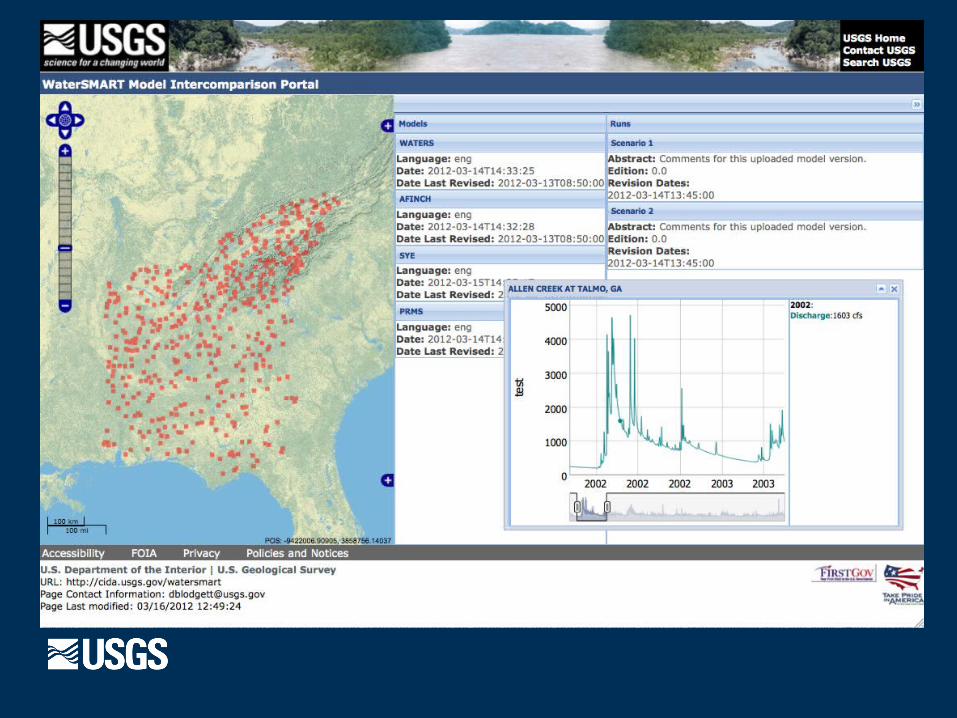
Near Term Project Objectives
· Develop a public web portal to serve daily flow estimates and stats at ungauged sites.· Initially support model intercomparison.· Extend to offer hydro/eco statistical indicators.· Provide access to ecologically relevant data.
· Aquatic biology and QW data via OGC-service stack.
· Enhanced hydrologic model creation methods.· Web Processing Service “data brokering”· Services to support integration of Bio/Eco data
Decision Support for Eco-Flows
· Currently scoping work to integrate aquatic biology and water quality data with ungauged flow estimates.
· Based on work done to integrate STORET and NWIS/QW (WQP)
· The US BioData/BioShare program plans to build standard services for aquatic biology· Implementation will support both enterprise and
“project-level” data systems (based on GeoServer)

High level conceptual architecture

WaterSmart Specific Architecture

Modeling-decision support lifecycle
1. Models built using enterprise data and services.
2. Calibrated model parameters and output contributed back to community portal.
3. Model input and output tracked and available to decision support via common standards.

Service Integrations to Note:
· ISO 19115/119-CSW Metadata Drives App.
· Feature time series – WMS/WFS and SOS.
· WPS outputs SOS or other web service.
· WPS “data-broker” consumes SOS to calculate Hydro/Eco statistics.