u.s. fish & wildlife service port louisa national … · t. davis moist soil unit, louisa...
TRANSCRIPT
Port LouisaNational WildlifeRefuge
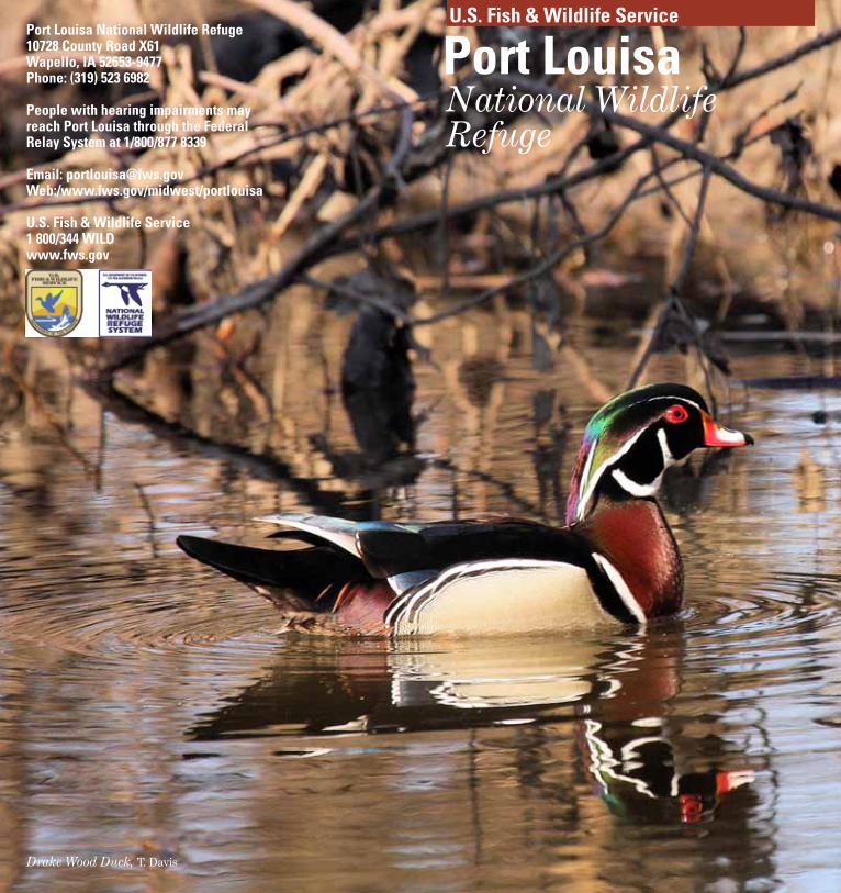
Drake Wood Duck, T. Davis
Port Louisa National Wildlife Refuge10728 County Road X61Wapello, IA 52653-9477Phone: (319) 523 6982
People with hearing impairments may reach Port Louisa through the Federal Relay System at 1/800/877 8339
Email: [email protected]:/www.fws.gov/midwest/portlouisa
U.S. Fish & Wildlife Service1 800/344 WILDwww.fws.gov
U.S. Fish & Wildlife Service
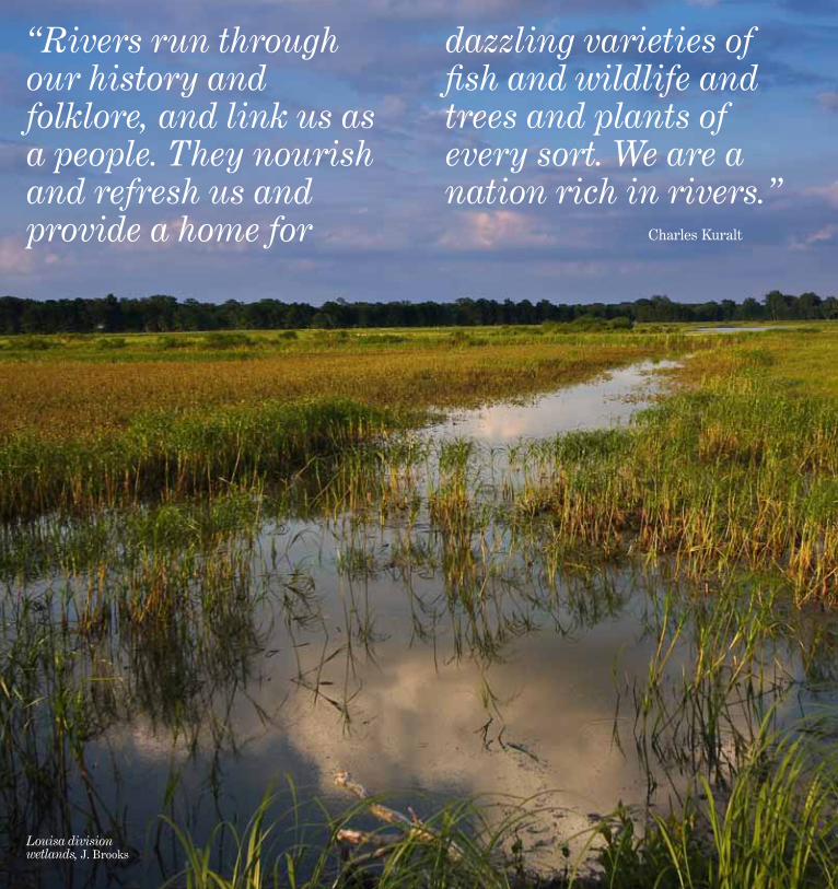
Louisa division wetlands, J. Brooks
“Rivers run through our history and folklore, and link us as a people. They nourish and refresh us and provide a home for
dazzling varieties of fish and wildlife and trees and plants of every sort. We are a nation rich in rivers.”
Charles Kuralt

Origins of the Refuge SystemConcerned about plummeting wading bird populations caused by hunters killing brown pelicans for their feathers to make women’s hats, President Theodore Roosevelt established tiny Pelican Island National Wildlife Refuge on March 14, 1903. He hired Paul Kroegel, a sometime cook, boat builder, and orange grower, to watch over the three-acre, shell-and mangrove-covered island in Florida’s Indian River.
Today, more than a century later, the National Wildlife Refuge System has grown to more than 100 million acres and more than 550 refuges - the only network of lands and waters dedicated to conserving our nation’s wildlife heritage for people today and generations to come.
Managed for Wildlife and PeoplePort Louisa National Wildlife Refuge is located in southeastern Iowa and protects 8,375 acres on the Mississippi River and 10,000 acres on the Iowa River. Although the U.S. Fish and Wildlife Service (Service) managed lands as early as the 1940s, it was not formally designated as a national wildlife refuge until 1958. The refuge provides important migration and nesting habitat for more than 278 species of birds, and millions of birds pass through the refuge each year on their annual migrations. The Mississippi Flyway is one of the most important migration corridors in North America.
The refuge is managed by the Service to conserve and enhance the quality and diversity of fish and wildlife and their habitats, and to restore floodplain functions in the river corridor.
Port LouisaNWR
IOWA
President Theodore Roosevelt, USFWS
Paul Kroegel, USFWS
Pelican feathers were used to make
women’s hats, USFWS
Fox Pond outlet, Louisa division, J. Brooks
American white pelican, J. Brooks
Red-bellied woodpecker, J. Denger
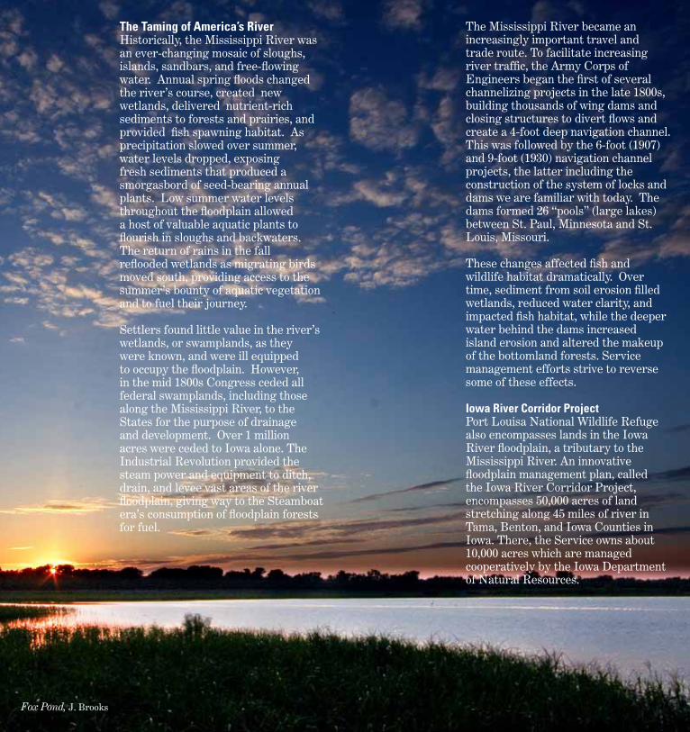
The Taming of America’s River Historically, the Mississippi River was an ever-changing mosaic of sloughs, islands, sandbars, and free-flowing water. Annual spring floods changed the river’s course, created new wetlands, delivered nutrient-rich sediments to forests and prairies, and provided fish spawning habitat. As precipitation slowed over summer, water levels dropped, exposing fresh sediments that produced a smorgasbord of seed-bearing annual plants. Low summer water levels throughout the floodplain allowed a host of valuable aquatic plants to flourish in sloughs and backwaters. The return of rains in the fall reflooded wetlands as migrating birds moved south, providing access to the summer’s bounty of aquatic vegetation and to fuel their journey.
Settlers found little value in the river’s wetlands, or swamplands, as they were known, and were ill equipped to occupy the floodplain. However, in the mid 1800s Congress ceded all federal swamplands, including those along the Mississippi River, to the States for the purpose of drainage and development. Over 1 million acres were ceded to Iowa alone. The Industrial Revolution provided the steam power and equipment to ditch, drain, and levee vast areas of the river floodplain, giving way to the Steamboat era’s consumption of floodplain forests for fuel.
The Mississippi River became an increasingly important travel and trade route. To facilitate increasing river traffic, the Army Corps of Engineers began the first of several channelizing projects in the late 1800s, building thousands of wing dams and closing structures to divert flows and create a 4-foot deep navigation channel. This was followed by the 6-foot (1907) and 9-foot (1930) navigation channel projects, the latter including the construction of the system of locks and dams we are familiar with today. The dams formed 26 “pools” (large lakes) between St. Paul, Minnesota and St. Louis, Missouri.
These changes affected fish and wildlife habitat dramatically. Over time, sediment from soil erosion filled wetlands, reduced water clarity, and impacted fish habitat, while the deeper water behind the dams increased island erosion and altered the makeup of the bottomland forests. Service management efforts strive to reverse some of these effects.
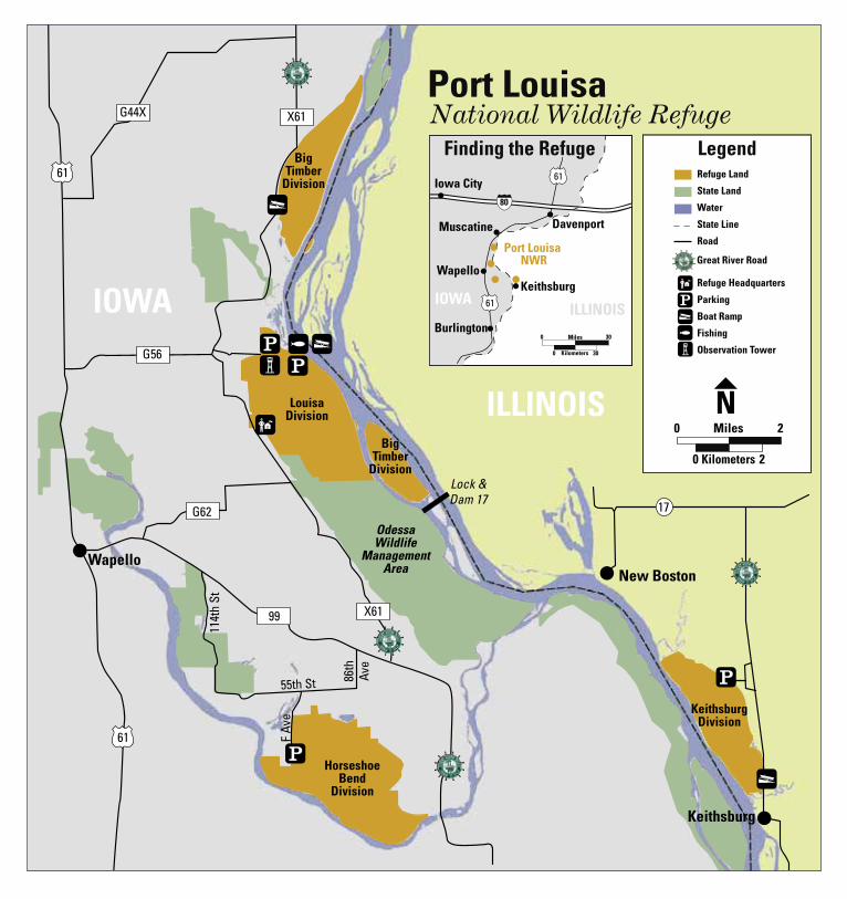
Iowa River Corridor ProjectPort Louisa National Wildlife Refuge also encompasses lands in the Iowa River floodplain, a tributary to the Mississippi River. An innovative floodplain management plan, called the Iowa River Corridor Project, encompasses 50,000 acres of land stretching along 45 miles of river in Tama, Benton, and Iowa Counties in Iowa. There, the Service owns about 10,000 acres which are managed cooperatively by the Iowa Department of Natural Resources.
Fox Pond, J. Brooks
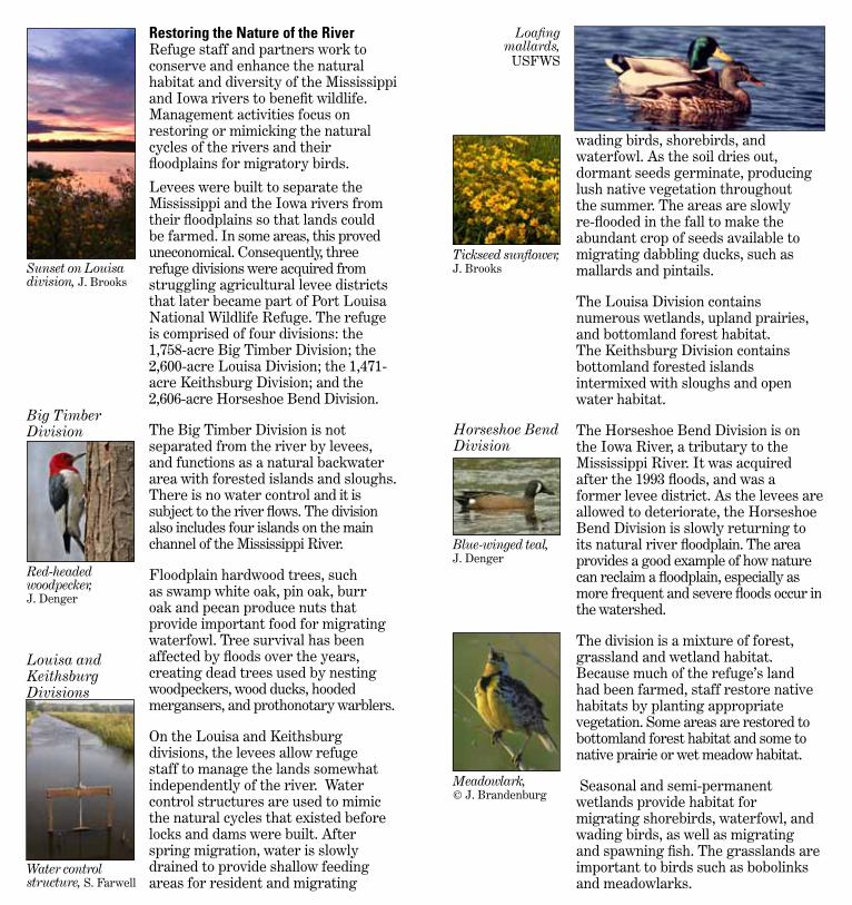
Louisa and Keithsburg Divisions
wading birds, shorebirds, and waterfowl. As the soil dries out, dormant seeds germinate, producing lush native vegetation throughout the summer. The areas are slowly re-flooded in the fall to make the abundant crop of seeds available to migrating dabbling ducks, such as mallards and pintails.
The Louisa Division contains numerous wetlands, upland prairies, and bottomland forest habitat. The Keithsburg Division contains bottomland forested islands intermixed with sloughs and open water habitat.
The Horseshoe Bend Division is on the Iowa River, a tributary to the Mississippi River. It was acquired after the 1993 floods, and was a former levee district. As the levees are allowed to deteriorate, the Horseshoe Bend Division is slowly returning to its natural river floodplain. The area provides a good example of how nature can reclaim a floodplain, especially as more frequent and severe floods occur in the watershed.
The division is a mixture of forest, grassland and wetland habitat. Because much of the refuge’s land had been farmed, staff restore native habitats by planting appropriate vegetation. Some areas are restored to bottomland forest habitat and some to native prairie or wet meadow habitat.
Seasonal and semi-permanent wetlands provide habitat for migrating shorebirds, waterfowl, and wading birds, as well as migrating and spawning fish. The grasslands are important to birds such as bobolinks and meadowlarks.
Restoring the Nature of the River Refuge staff and partners work to conserve and enhance the natural habitat and diversity of the Mississippi and Iowa rivers to benefit wildlife. Management activities focus on restoring or mimicking the natural cycles of the rivers and their floodplains for migratory birds.
Levees were built to separate the Mississippi and the Iowa rivers from their floodplains so that lands could be farmed. In some areas, this proved uneconomical. Consequently, three refuge divisions were acquired from struggling agricultural levee districts that later became part of Port Louisa National Wildlife Refuge. The refuge is comprised of four divisions: the 1,758-acre Big Timber Division; the 2,600-acre Louisa Division; the 1,471-acre Keithsburg Division; and the 2,606-acre Horseshoe Bend Division.
The Big Timber Division is not separated from the river by levees, and functions as a natural backwater area with forested islands and sloughs. There is no water control and it is subject to the river flows. The division also includes four islands on the main channel of the Mississippi River.
Floodplain hardwood trees, such as swamp white oak, pin oak, burr oak and pecan produce nuts that provide important food for migrating waterfowl. Tree survival has been affected by floods over the years, creating dead trees used by nesting woodpeckers, wood ducks, hooded mergansers, and prothonotary warblers.
On the Louisa and Keithsburg divisions, the levees allow refuge staff to manage the lands somewhat independently of the river. Water control structures are used to mimic the natural cycles that existed before locks and dams were built. After spring migration, water is slowly drained to provide shallow feeding areas for resident and migrating
Sunset on Louisa division, J. Brooks
Tickseed sunflower, J. Brooks
Blue-winged teal, J. Denger
Meadowlark, © J. Brandenburg
Red-headed woodpecker, J. Denger
Water control structure, S. Farwell
Big Timber Division
Loafingmallards,
USFWS
Horseshoe Bend Division
Prescribed fire is also used to rejuvenate floodplain grassland and wet meadow habitat on the Horseshoe Bend Division. Carefully controlled fires remove dead vegetation, deter non-native plants and shrubs, and stimulate new growth of native plants. Specially trained personnel determine the weather conditions necessary for conducting a safe burn, and monitor the fire constantly.
Most of the refuge land in the Iowa River Corridor Project has reverted from cropland back to its former habitat of wet meadow, oxbow wetlands, grassland, and bottomland forest, with a mixture of scrub/shrub openings. Much of it has been restored by planting to native vegetation, although much remains to be done.
Grasslands and wet meadows are managed with prescribed fire and offer habitat for several species of prairie songbirds as well as pheasants and bobwhite quail. Bottomland forests provide migration and nesting habitat for many warblers and other woodland songbirds.
Enjoying the Refuge The Service encourages you to visit, explore, and learn about Port Louisa National Wildlife Refuge. Enjoy refuge lands by fishing, hunting, bird watching, biking, hiking, canoeing, and boating. Guided tours may be arranged by contacting the refuge in advance.
Trails are available year-around in the Louisa Division. You can hike Spring Slough Road and the levee at the Keithsburg Division when water levels allow. Contact the refuge for current trail conditions.
Iowa River Corridor Project
Ring-necked pheasant, D. Menke, USFWS
Painted turtle, T. Davis
Moist soil unit, Louisa division, S. Farwell
Igniting a prescribed fire, USFWS
Migrating shorebirds, waterfowl, and songbirds stop on their way to northern breeding grounds. Louisa Division trails and the Keithsburg levee are the best places to see colorful warblers and other songbirds before leaves fully emerge on trees. Migrating waterfowl can also be seen from trails. As water is drawn down on the Louisa Division, wading birds are abundant and later in the summer shorebirds again appear on their way to the wintering grounds. Wood duck and hooded merganser broods appear. Bitterns and rails are often heard. Frogs and turtles are abundant.
Large flocks of waterfowl stop to rest and refuel while traveling to their southern wintering grounds. A great variety of dabbling and diving ducks are present as well as thousands of geese. Although much of the refuge is closed during the migration to allow waterfowl to feed and rest, there are opportunities to view waterfowl. Contact the refuge for locations and dates.
Large numbers of bald eagles winter in the Mississippi River corridor and can be seen roosting in shoreline trees and feeding where open-water conditions exist. Deer are commonly seen.
Spring
Summer
Fall
Winter
Changing seasons bring different reasons to visit Port Louisa National Wildlife Refuge!
Bald Eagle, D. Menke, USFWS
Eastern kingbird, T. Davis
Canada geese, J. Brooks
Great blue heron, J. Brooks
Bald eagle, S. Farwell

Some species can be found on the refuge at all times of the year. Wild turkeys, northern bobwhite quail, pileated woodpeckers, northern cardinals, hairy woodpeckers, Carolina wrens, tufted titmice, and great horned owls are year-round residents.
Visiting Port Louisa National Wildlife Refuge We suggest that you begin your visit by stopping at refuge headquarters on the Louisa Division, near Wapello, Iowa. Office hours are Monday – Friday, 7:30 a.m. – 4:00 p.m.
From U.S. Highway 61, take county road G56 east four miles. Turn right at the stop sign onto county road X61. The refuge office will be one mile on the left. Signs are in place to direct you from Highway 61.
Louisa DivisionThe 2,600-acre Louisa Division is just east of Wapello, Iowa, in Louisa County. The refuge office is located on the bluff, where prairie has been restored and it meets upland hardwood forest. As you descend the bluff, the habitat changes to bottomland forest, wetland and grassland. Division wetlands have been managed primarily for migratory waterfowl since its conversion from an agricultural levee district to a national wildlife refuge.The division is bordered on the south by the Odessa Wildlife Management Area (WMA), which is managed by the Iowa Department of Natural Resources.
Designated water trails wind through the refuge and WMA for canoeing and kayaking. In addition, several trails are available on the refuge for hiking. Starting from the refuge headquarters, there is a short accessible trail to an overlook. From there, the Bluff Trail ventures down the hill where there are options for loop trails or hiking the 1.5 miles to the Muscatine Slough parking lot and overlook. This trail winds through bottomland sloughs and forest.
q
The refuge road in the Louisa Division can be used for hiking and bicycling for wildlife observation. It is a 5.4 mile loop. An overlook is available at Fox Pond about 2.2 miles in. Louisa Division is a migratory bird sanctuary from September 15 - December 31 and is closed to public entry during that time. Hunting is not permitted on the division; however, the Odessa WMA is popular with waterfowl hunters. A concrete boat ramp provides river access from the northern boundary of the Louisa Division. An accessible fishing pier allows anglers to cast their lines into the Odessa inlet ditch.
Finding Louisa From the headquarters, turn right on county road X61 and go 1 mile where you will see signs directing you to the Louisa Division. Turn right and follow this road about 1 mile until you meet the refuge boundary.
Keithsburg Division The 1,400-acre Keithsburg Division is immediately north of Keithsburg, Illinois, within Pool 18 of the Mississippi River. A three-mile levee separates it from the Mississippi River. The division is a mosaic of wetlands and bottomland forest. A remnant sand prairie exists adjacent to the boat ramp parking lot. The division is closed to public entry from September 15 - December 31 as a refuge for migratory waterfowl.
Hiking and fishing are allowed from January 1 through September 14. The Spring Slough parking lot provides access for hiking and bank fishing along an access road and levee.
g
Uy
oNorthern cardinal, G. Wege, USFWS
Swamp milkweed, M. Farwell
Canoers, USFWS
Fishermen, D. Stanley, USFWS
Trumpet vine, M. Farwell
gyo

Finding Keithsburg From Keithsburg, Illinois go 1/2-mile north on the Great River Road (76th Street) to reach the boat ramp. To reach the Spring Slough parking lot, continue north from the boat ramp for 3 miles. Turn left on 50th Street. Take the first left, and then the next right. Spring Slough parking lot will be on your left, just under 1 mile.
Horseshoe Bend DivisionHorseshoe Bend Division is in the Iowa River floodplain, in Louisa County, Iowa, approximately four miles upstream from where the Iowa meets the Mississippi. The division is closed September 15 - November 30 as a waterfowl sanctuary, but open to visitors the remainder of the year. Pheasant, deer and turkey hunting are allowed on this division in accordance with state regulations. Steel shot is required for all upland game hunting. Although there are no designated trails, there are service roads that can be used for hiking and bird watching.
Finding Horseshoe Bend From Wapello, take Hwy 99 east 1.5 miles to 114th Street. Turn right. Follow this winding gravel road 3.5 miles to F Avenue. Turn right. This road is a dead end with a parking lot.
Big Timber Division The 1,760-acre Big Timber Division is 5.5 miles north of refuge headquarters. Most of the division is a backwater of the river, with sloughs surrounded by bottomland forests. The division includes Turkey and Otter islands and Turkey Towhead, located a few miles downstream, near Lock and Dam 17, and Ramsey Island, in the main river channel. These are accessible only by boat.
Monarch butterfly, J. Brooks
Dickcissel, J. Brooks Eastern
pondhawk dragonfly, S. Farwell
Prickly pear cactus, M. Farwell

Merganser and Woodies, J. Denger
Big Timber’s main recreational attractions are fishing and hunting. The backwaters are accessible by boat from the Mississippi River or from the boat ramp located on the southwestern edge. Bank fishing is available near the parking lot.
Finding Big Timber From refuge headquarters, turn north on county road X61 and follow this 5.5 miles to the boat ramp for Big Timber. Turn right at the sign and follow the short road over the levee and into the boat ramp. This is the main access to the division.
Corridor Maps
E
g
N
y
U
Happy hunter! USFWS
Greater yellowlegs, J. Brooks
Public Use Regulations The refuge is open from sunrise to
sunset. Fishing is allowed on all divisions
when they are open. Bicycling is allowed on refuge roads. Hiking is provided on several trails –
see each division’s information. Berry and mushroom gathering are
allowed for personal consumption only. Pets must be on a leash, except when
used for hunting.
See each Division for hunting information. Some parts of the refuge are closed during migration periods.
Iowa River Corridor Refuge lands in the corridor offer exceptional recreational opportunities for outdoor enthusiasts. The area is known for large populations of whitetail deer, turkey, and pheasant. Waterfowl hunting is allowed except on designated sanctuary areas. Other popular recreational activities include bird and wildlife watching, canoeing, boating and hiking.
Corridor lands are managed by the Iowa Department of Natural Resources in cooperation with the Fish and Wildlife Service. The Iowa River corridor properties are scattered throughout several counties. Maps can be found at: http://www.iowadnr.gov/wildlife/wmamaps/maps/irc.pdf.
White-tailed deer, J. Brooks
E
g
N
BigTimber
Division
BigTimber
Division
KeithsburgDivision
HorseshoeBend
Division
Keithsburg
New Boston
LouisaDivision
Wapello
OdessaWildlife
ManagementArea
Lock &Dam 17
55th St 86th
Ave
114t
h St
F Av
e
G44X X61
G56
99 X61
17
61
61
I
o
q
I
I
o
IOWA
ILLINOIS
G62
ILLINOISIOWA
Muscatine
Iowa City
Wapello
Burlington
Keithsburg
Davenport
Port Louisa NWR
0 30
0 30
Miles
Kilometers
oIq
Refuge Land
State Land
Water
State Line
Road
Refuge Headquarters
Parking
Boat Ramp
Fishing
Observation Tower
Great River Road
Finding the Refuge Legend
o
Kilometers
Miles0 2
0 2
N
National Wildlife RefugePort Louisa
80
61
61
MIt M
t