use of digital imagery in fpra effectiveness evaluation program: a case study stéphane dubé, nifr...
TRANSCRIPT

Use of digital imagery in FPRA Use of digital imagery in FPRA Effectiveness Evaluation Effectiveness Evaluation Program: A Case StudyProgram: A Case Study
StStééphane Dubphane Dubéé, NIFR Soil Scientist, NIFR Soil Scientist
Fred Berekoff, PG District Stewardship ForesterFred Berekoff, PG District Stewardship Forester
RSM Program Pilot Post-Mortem Meeting, Victoria
February 2005

OutlineOutline
The office portion of an Effectiveness The office portion of an Effectiveness Evaluation for FRPA resource values: Why Evaluation for FRPA resource values: Why and How?and How?
Brief overview of high quality image types. Brief overview of high quality image types.
Case study in Prince George Pilot District.Case study in Prince George Pilot District.
What did we learn?What did we learn?
Office review of background Office review of background informationinformation
Prior to collecting data in the field, an office review is Prior to collecting data in the field, an office review is essential for planning and implementing the field portion of essential for planning and implementing the field portion of the Effectiveness Evaluation (EE) pilots for a resource value. the Effectiveness Evaluation (EE) pilots for a resource value.
It is desirable that the office review procedure:It is desirable that the office review procedure:(1) be agreed upon by the field crews(1) be agreed upon by the field crews
(2) used the best information available, and (2) used the best information available, and
(3) integrate GPS and GIS tools together to create sampling layout and (3) integrate GPS and GIS tools together to create sampling layout and obtain detailed measurements. obtain detailed measurements.
This will ensure that data collection is successful i.e. time-saver, cost This will ensure that data collection is successful i.e. time-saver, cost effective and consistently applied across the Province.effective and consistently applied across the Province.

Office review of background Office review of background informationinformation
Prior to collecting data in the field, an office review is essential Prior to collecting data in the field, an office review is essential for planning and implementing the field portion of the for planning and implementing the field portion of the Effectiveness Evaluation (EE) pilots for a resource value. Effectiveness Evaluation (EE) pilots for a resource value.
It is desirable that the office review procedure:It is desirable that the office review procedure:(1) be agreed upon by the field crews(1) be agreed upon by the field crews
(2) used the best information available, and (2) used the best information available, and
(3) integrate GPS and GIS tools together to create sampling layout and (3) integrate GPS and GIS tools together to create sampling layout and obtain detailed measurements. obtain detailed measurements.
This will ensure that data collection is successful i.e. time-saver, cost This will ensure that data collection is successful i.e. time-saver, cost effective and consistently applied across the Province.effective and consistently applied across the Province.
To assist district staff with assessing the various indicators for the To assist district staff with assessing the various indicators for the soils value, we have developed a field assessment procedure that soils value, we have developed a field assessment procedure that make use of recent high quality images. make use of recent high quality images.

Brief overview of digital imageryBrief overview of digital imagery Various digital image types available but not all types are Various digital image types available but not all types are
good choice:good choice: low and high resolution satellites, aerial photography, oblique photo.low and high resolution satellites, aerial photography, oblique photo.
How is it done?How is it done? Landsat, light-wing aircraft, helicopter, and high vantage points. Landsat, light-wing aircraft, helicopter, and high vantage points.
How accurate it is?How accurate it is? Spatial resolution is critical for image recognition from 10cm pixel size Spatial resolution is critical for image recognition from 10cm pixel size
(CWD can be seen) to 30m pixel size (large beetle patch). (CWD can be seen) to 30m pixel size (large beetle patch). E.g. 50cm pixel size 3,600 times better than 30m pixel size. E.g. 50cm pixel size 3,600 times better than 30m pixel size.
Integration of GPS and GIS togetherIntegration of GPS and GIS together That allow you to import data and work with maps and/or digital That allow you to import data and work with maps and/or digital
images. When geo-referenced (using a coordinate system), area images. When geo-referenced (using a coordinate system), area calculation, distance measurements, and other GIS tasks can be made. calculation, distance measurements, and other GIS tasks can be made.
Entry-level GIS mapping softwares: ERMapper, OziExplorer, Entry-level GIS mapping softwares: ERMapper, OziExplorer, ArcView.ArcView.
Data are collected using mobile GPS devices such as Garmin receivers Data are collected using mobile GPS devices such as Garmin receivers

Case studyCase study
Using a recent high resolution aerial photo (10cm Using a recent high resolution aerial photo (10cm pixel size) of a randomly selected block displayed in pixel size) of a randomly selected block displayed in OziOziExplorerExplorer, evaluation of certain EE Soils , evaluation of certain EE Soils indicators can be made including:indicators can be made including: identification and delineation of features of interest identification and delineation of features of interest
visible from the air;visible from the air; area and distance measurements, and;area and distance measurements, and; planning of walkthroughs and survey transectsplanning of walkthroughs and survey transects

Green Tree Retention & CWDGreen Tree Retention & CWD

Permanent Access and Green Permanent Access and Green Tree RetentionTree Retention
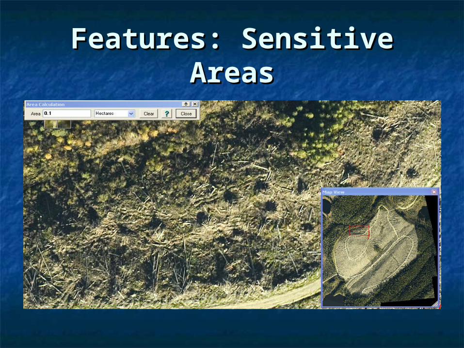
Features: Sensitive AreasFeatures: Sensitive Areas

Features: Drainage PatternsFeatures: Drainage Patterns

Field Map: Planned transectsField Map: Planned transects

What Did We LearnWhat Did We Learn As part of a successful EE, the review of background As part of a successful EE, the review of background
information is essential. information is essential.

What Did We LearnWhat Did We Learn As part of a successful EE, the review of background As part of a successful EE, the review of background
information is essential. information is essential. However, the office review is as good as the quality of However, the office review is as good as the quality of
the information we get from it. the information we get from it.

What Did We LearnWhat Did We Learn As part of a successful EE, the review of background As part of a successful EE, the review of background
information is essential. information is essential. However, the office review is as good as the quality of However, the office review is as good as the quality of
the information we get from it. the information we get from it. Higher resolution digital images provide accurate and Higher resolution digital images provide accurate and
reliable information useful when:reliable information useful when:(1) implementing the field assessment;(1) implementing the field assessment;(2) evaluating the indicators, and;(2) evaluating the indicators, and;(3) reporting and interpreting results.(3) reporting and interpreting results.
Varying levels of evaluation intensity: Varying levels of evaluation intensity: overview overview ↔↔ qualitative qualitative ↔↔ quantitative quantitative

What Did We LearnWhat Did We Learn In the foreseeable future:In the foreseeable future:
Images are shared among Value Teams and other potential Images are shared among Value Teams and other potential users.users.

What Did We LearnWhat Did We Learn In the foreseeable future:In the foreseeable future:
Images are shared among Value Teams and other potential Images are shared among Value Teams and other potential users.users.
Conduct cost-comparisons of different image types based Conduct cost-comparisons of different image types based on sensing needs, spatial resolution, availability and turn-on sensing needs, spatial resolution, availability and turn-around time processing.around time processing.
Investigate portable mobile devices with GPS and GIS Investigate portable mobile devices with GPS and GIS integrated.integrated.