usfs oct 07 greece final report
DESCRIPTION
2007 Post-fire emergency response cooperation with USATRANSCRIPT

TECHNICAL COLLABORATION BETWEEN THE
UNITED STATES AND GREECE IN POST-FIRE EMERGENCY RESPONSE
FINAL REPORT
OCTOBER 14 – 27, 2007
.

U.S. Government Technical Team to Greece: October 14-27, 2007
Final Report Page 2
ACKNOWLEDGEMENTS The team would like to extend their gratitude to all who supported this mission and helped make it possible. In particular, we would like to acknowledge Ken Zurcher, the Economic Officer at the United States Embassy in Athens, and Soula Prasinou, Foreign Service National Investigator for the Regional Security Office, also at the United States Embassy in Athens, for all of their efforts coordinating this visit with the U.S. Embassy and the Greek General Directorate of Development and Protection of Forests and Natural Environment. Both were key members of the team during our meetings in Athens and many of our field visits in the Peloponnese over the two week period of our mission. They contributed invaluable insight about the country and operating agencies and provided outstanding logistical support throughout the mission. We are also grateful to many staff within the Greek General Directorate of Development and Protection of Forests and Natural Environment at the Ministry of Rural Development and Food, both in Athens and the regions for all of their time, technical knowledge, and collaborative hospitality during our mission to Greece. In particular, our time with Forestry Department Officials Vereniki Louka, Lattas Panagiotis, Aris Michos, Marinos Koulousianis, demonstrated the high caliber of technical exchange possible between the United States and Greece. They provided invaluable insight and were very open towards technical exchange. We learned a great deal from them and hope our inputs and dialogue also proved useful for their continued forestry work and post-fire restoration activities. Cover Page Photos: Left: Team members analyzing maps of the area in Pyrgos; Right: Site visit by Team members in Kladeos watershed. Both photos taken by Yoni Bock, USAID/OFDA.

U.S. Government Technical Team to Greece: October 14-27, 2007
Final Report Page 3
TABLE OF CONTENTS ACKNOWLEDGEMENTS 2 ACRONYM LIST 4 EXECUTIVE SUMMARY 5 1. BACKGROUND 7 2. SCOPE OF TECHNICAL ASSISTANCE 8 3. U.S. INTERAGENCY TEAM ITINERARY 10 4. BURNED AREA EMERGENCY RESPONSE PROCESSES IN THE U.S. 11 5. KLADEOS CASE STUDY: OBSERVATIONS, FINDINGS AND 12
RECOMMENDATIONS 5.1 Prioritization of High Risk Areas 13 5.2 Soil Burn Severity vs. Vegetation Burn Severity 13 5.3 Post-Burn Treatments 14 5.4 High Risk Areas Identified 15 a. Watershed response 15 b. Flash flooding 16 c. Debris Flow 16 5.5 Municipality and Government Agency Coordination in 16
Post Fire Rehabilitation 6. GENERAL RECOMMENDATIONS 17 6.1 Remote Sensing Imagery and GIS 17 6.2 Monitoring of Current and Alternative Post Burn Treatments 18 6.3 Stakeholder Coordination in Post-Fire Remediation Efforts 19 7. NEXT STEP ISSUE AREAS 19 7.1 BAER Process Follow-Up Activities 20 7.2 Incident Command System Training: Interagency Coordination 20 7.3 Fire Suppression Tactical Trainings 20 APPENDIX 1: Mission Itinerary 22
APPENDIX 2: List of Contacts 23 APPENDIX 3: BAER Technical Report 24

U.S. Government Technical Team to Greece: October 14-27, 2007
Final Report Page 4
LIST OF ACRONYMS BAER Burned Area Emergency Response DASP Disaster Assistance Support Program EROS Earth Resources Observation System GIS Geographical Information Systems GOG Government of Greece ICS Incident Command System LEB Log Erosion Barrier NGO Nongovernmental Organization OFDA Office of U.S. Foreign Disaster Assistance RS Remote Sensing RSAC Remote Sensing Applications Center USAID United States Agency for International Development USD United States Dollar USDA United States Department of Agriculture USFS United States Forest Service USG United States Government USGS United States Geological Survey

U.S. Government Technical Team to Greece: October 14-27, 2007
Final Report Page 5
EXECUTIVE SUMMARY For a period of two weeks in October 2007, a team of seven United States Government (USG) specialists from the United States Department of Agriculture Forest Service (USFS) and the United States Agency for International Development Office of U.S. Foreign Disaster Assistance (USAID/OFDA) traveled to Greece to work with the General Directorate of Development and Protection of Forests and Natural Environment in the Ministry of Rural Development and Food to address post-fire emergency impacts and share response and mitigation tools. The October mission was a direct recommendation from an earlier USG team to Greece in September 2007, immediately following the devastating August fires and the Greek Government’s subsequent request for international assistance. In early September, the USG had outlined a support package for Greece that provided funding for immediate short-term needs, such as emergency relief supplies and fire protective equipment; deployment of short-term technical assistance teams to work with Greek counterparts in assessing post-fire conditions; and a longer term technical exchange program to share ideas, tools, and experiences in fire management and disaster preparedness. This October 2007 technical team and the initial September 2007 trip are part of the short-term technical assistance activities. The purpose of the October 2007 technical mission was to share post-fire assessment technologies and processes with Greek colleagues to identify areas of highest risk and to outline possible technical interventions to minimize and/or mitigate those risks. The emphasis of the visit was on USFS Burned Area Emergency Response (BAER) tools which through the use of GIS and satellite-derived burn severity maps help identify values at risk and determine if the fire created an emergency to life and or property. An additional objective was to further discuss a longer term technical exchange program on how the USG, in particular the experiences of the USFS, could assist the Government of Greece (GOG) to improve overall disaster preparedness and fire management capabilities. The USG team held meetings in Athens and then immediately traveled to Olympia in the Western Peloponnese Region to assess, analyze and suggest mitigations in the Kladeos watershed. The Kladeos watershed was selected by the Greek members of the team as a case study because it was particularly impacted by the fires and it had special importance due to its proximity to Ancient Olympia. Together with four Greek forestry officials, the U.S. Team created a joint BAER team to assess fire-induced flood and erosion hazards and possible treatment options in the watershed. Immediately following the watershed assessment, the BAER team drafted a technical report which documents the process, methodology, statistical analysis, imagery, data and field verification methods used to identify high risk areas in the Kladeos watershed as well as suggested treatment options. The BAER Technical Report can be found in Appendix 3. In addition to specific suggestions for the Kladeos watershed, several key findings and observations were made on general disaster preparedness and fire management activities in Greece. One key finding was the need for greater agency and stakeholder coordination among the different ministries of the GOG involved in fire response and post-fire restoration, including improved information sharing. For example, municipalities and land owners were installing new culverts and maintaining channel openings without the benefit of upper watershed assessments

U.S. Government Technical Team to Greece: October 14-27, 2007
Final Report Page 6
made by forestry officials. Another example: River basin plans which are developed by the Ministry of Environment would be useful information for land managers within forestry, including national, prefecture, and municipal forestry officials as they begin recovery activities in the watershed. Optimally, land management agencies should have a better understanding of fire impact throughout the watershed, which will in turn improve effective decision-making. This final report summarizes the overall key findings made by the joint Greek – U.S. technical team working on the Kladeos watershed and also highlights observations and discussions the U.S. team had throughout their mission. Recommendations and suggestions are included with these findings, outlining possible activity areas for the longer term technical exchange program. The intent of both the BAER Technical Report and this Final Report is to share experiences and findings in order to promote further dialogue among the appropriate agencies that address fire management and disaster preparedness measures in both the U.S. and Greece.

U.S. Government Technical Team to Greece: October 14-27, 2007
Final Report Page 7
1. BACKGROUND The 2007 wildfire season in Greece was the worst on record, killing 76 people, destroying nearly 3,000 buildings, and burning 327,000 hectares on Evia Island, the Island of Crete and the Western Peloponnese, with significant human, agricultural and economic costs. The GOG Ministries of National Economy and Agricultural Development estimated that the total damage to the agriculture sector alone may exceed 1.5 billion Euros (more than USD 2.1 billion). Because of the widespread damage, the Greek government declared a state of emergency on August 25, 2007. To show support and allow for the provision of U.S. emergency assistance to Greece, Thomas Countryman, the U.S. Embassy Charge d’Affaires, declared a disaster on August 27 due to the magnitude of the wildfires, related loss of life, and damage to property and livelihoods. USAID/OFDA provided an initial USD 100,000 to the Hellenic Red Cross for the local procurement of emergency relief supplies. In addition, USAID/OFDA provided further funding to initiate a technical assistance program in collaboration with the USFS Disaster Assistance Support Program (DASP) to address immediate short-term needs, including the provision of additional emergency relief supplies and fire fighting equipment as well as a longer-term program to strengthen Greek fire management and disaster response capacities. Overall, U.S. assistance to Greece, including both immediate and longer-term activities, totals more than USD 2.1 million. The first technical assistance team, consisting of six USAID/OFDA and USFS specialists, traveled to Greece from September 2 to 8, 2007. The team’s objective was to assess the impact of the wildfires, evaluate potential hazards created by newly burned terrain, and identify technical cooperation possibilities with GOG to address the current emergency and longer term wildfire management. The first USG team observed a number of areas in the Peloponnese region that demonstrated steep and/or unstable slopes and high burn severity in close proximity to population centers, agricultural fields, roads, infrastructure, and world heritage archeological sites (see example in Figure 3). Surviving structures, such as homes and cottage businesses in small village communities as well as the ancient stadium in Olympia, were seen as potentially at high risk from subsequent debris flows during the upcoming rainy season. The USG assessment team concluded that such hazards should be evaluated as soon as possible to prevent further loss of life and property. The team was particularly concerned about landslides and wash-outs in villages served by a single access road, which could isolate flood affected populations during the rainy season.
Figure 3: Village located at base of burned area and possible unstable slopes. Photo: Annette Parsons, USFS.

U.S. Government Technical Team to Greece: October 14-27, 2007
Final Report Page 8
Therefore, the team recommended follow-on evaluations of landslide and flooding hazards in fire-affected areas, including the preparation of burn severity maps based on remote sensing (RS) and geographic information systems (GIS) data and by deploying a USFS BAER Team to share post-fire assessment tools such as burn severity maps and BAER processes with Greek counterparts.
Since the GOG was particularly interested in the rapid burn severity maps, the September USG team recommended the USFS prepare such maps for fire-affected areas of Greece. Using different colors, the maps show highest, moderate and low burn severity areas and can be overlayed with villages and roads to target areas of potentially highest risk. This can be an extremely useful tool when large areas have been burned. As such, following the initial team visit, USFS specialists worked with the USFS Remote Sensing Applications Center (RSAC) and the U.S. Geological Survey Earth Resources Observation Systems Data Center (USGS EROS) to acquire pre- and post- fire imagery for most of the Greek areas burned in August (see figure 4 for an example). Once the pre- and post- fire imagery was obtained, remote sensing specialists at USFS RSAC developed preliminary soil burn severity
maps for affected areas. The initial September USG team recommended that a second team return to Greece to work with Greek counterparts using the burn severity maps in conjunction with other BAER tools and processes to help identify possible post-fire emergency situations, including areas that would be at risk from erosion and landslides following winter storms. A second technical mission was therefore developed and took place from October 14 to 27, 2007. This final report summarizes the itinerary and activities of this second USG team mission and offers observations, recommendations and possible next steps for further Greek – U.S. collaboration to address fire management and disaster response capacity in Greece. 2. SCOPE OF TECHNICAL MISSION A seven person interagency technical team made up of USAID/OFDA and USFS specialists traveled to Greece from October 14 to 27, 2007. The purpose of their mission was to share post-fire assessment technologies with Greek colleagues, demonstrating the utility of satellite-derived burn severity maps and site specific analyses in identifying areas of highest flood and erosion risk, and to discuss technical interventions to minimize or mitigate those risks. The team included:
♦ Brendan Bartow, USAID/OFDA, GIS Specialist/Cartographer, Washington D.C; ♦ Yoni Bock, USAID/OFDA, Documentation Specialist, Washington D.C;
Figure 4: Soil Burn Severity map of the Pelopponese Region courtesy of RSAC.

U.S. Government Technical Team to Greece: October 14-27, 2007
Final Report Page 9
♦ Dr. Tom Koler – USFS, Licensed Geologist; Placerville, California; ♦ Carolyn Napper - USFS, Certified Professional in Erosion and Sediment Control, Soil
Scientist, and Hydrologist; San Dimas Technology and Development Center, San Dimas, California;
♦ Melissa Othman – USFS IP, Technical Program Specialist, Technical Cooperation Unit, Washington D.C;
♦ Annette Parsons – USFS, Certified Professional in Sediment and Erosion Control, GIS Analyst and Remote Sensing Specialist; USFS Remote Sensing Applications Center, Salt Lake City, Utah
♦ Dr. Sezin Tokar - USAID/OFDA, Hydrometeorological Hazard Advisor, Washington D.C.
The team objective was to identify, evaluate and prioritize potential hazards created by newly burned terrain and their possible treatment options with representatives from the General Directorate of Development and Protection of Forests and Natural Environment in the Ministry of Rural Development and Food who oversee much of the burned area restoration activities in Greece. This was done through information gathering and analysis, both in the office and in the field; mapping soil burn severity; field assessment techniques; soil and slope analysis; and data integration using locally available topographical and geological data to run for example, slope stability and erosion models. Prior to the USG team arrival, representatives from the General Directorate of Development and Protection of Forests and Natural Environment identified two priority areas that would be suitable for technical collaboration: Olympia and Kalavrita. Following initial discussions between the GOG and the USG team, both groups agreed to focus on a single site as a case study in order to appropriately convey BAER processes and tools and to discuss possible mitigation measures. The case study would highlight whether BAER tools and processes would be appropriate and useful for Greece; how they may need to be adapted; and their applicability to other fire-affected areas. Furthermore, the technical exchange would allow for dialogue on ways to strengthen post-fire risk assessment processes currently used in Greece. Greek officials identified the area surrounding the town of Olympia in Western Peloponnese as the most appropriate for the case study. The primary reason for choosing Olympia was that it was located in one of the areas most severely impacted by the fires and its special cultural importance due to its proximity to Ancient Olympia. Once in Olympia, the US team worked with four GOG forestry specialists from national and prefecture offices. They included:
♦ Marinos Koulousianis - Forester/Hydrological Engineer; ♦ Vereniki Louka - Forester/Hydrologist; ♦ Aris Michos - Forester/GIS; and ♦ Lattas Panagiotis - Forest Engineer.
During initial discussions in Pyrgos on October 17, 2007, the Greek and U.S. team further narrowed the case study site to the Kladeos watershed. The Kladeos basin is a tributary to the

U.S. Government Technical Team to Greece: October 14-27, 2007
Final Report Page 10
Alpheos River below the town of Olympia. In addition to being a major tourist attraction, the uniquely historical town of Olympia includes a cultural museum, ancient ruins, and the Olympic game fields. Additionally, Olympia is the location where the Olympic torch will be lighted for the upcoming Olympic 2008 Games in Beijing, China. The specific goals for the case study included:
• Share USFS BAER processes and assessment including its strengths and weaknesses. • Learn from our Greek counterparts their process, resources, and treatment tools used in
post-fire response. • Share GIS tools and satellite image-derived maps for rapidly identifying high burn
severity areas, prioritizing analysis, and discussing potential treatment locations. • Conduct field investigations to validate satellite maps of soil burn severity mapping,
water repellency identification, and potential values at risk. • Identify if and where the wildfire created an emergency to life, safety, property, and other
natural or cultural resources. • Discuss potential treatment options for more in-depth analysis with the Greek Forestry
team members. 3. U.S. GOVERNMENT TEAM ITINERARY Initial meetings took place in Athens with representatives of the U.S. Embassy and the General Directorate of Development and Protection of Forests and Natural Environment in the Ministry of Rural Development and Food. The USFS team members provided background on the BAER process, sharing some of the imagery that was developed by USFS RSAC prior to the team’s arrival, and how these tools could help GOG prioritize activities in severely burned areas, The team then traveled to Olympia in the Ilia Prefecture and spent seven days working with the four Greek forestry officials as a joint BAER assessment team. During the time in Olympia, the group visited field sites to assess burn severity to soils, verified and refined imagery and data, and then discussed and compared tools, processes and mitigation measures in addressing post-fire impacts in the Kladeos watershed. Following the field work, the team traveled to Patras on October 22 and presented their findings to the Patras Municipality, Prefecture Forestry offices, and other municipal agencies. Back in Athens from October 23 to 26, the team briefed Embassy officials, the Deputy Minister within the Ministry of Rural Development and Food, and representatives from the General Directorate of Development and Protection of Forests and Natural Environment on their findings and conclusions. In addition to discussion with Forestry officials, the team also met with GOG representatives from the Interior Ministry including the Hellenic Fire Brigade and the Department of Emergency Planning in the General Secretariat for Civil Protection, staff from local non-governmental organizations (NGOs), and academic geologists from the local polytechnic university (For a complete list of contacts, please see Appendix 2). In these meetings, the U.S. team explored the extent to which other parts of the GOG and Greek organizations utilize GIS and satellite-based mapping technologies and how the

U.S. Government Technical Team to Greece: October 14-27, 2007
Final Report Page 11
government coordinates in emergency response. A complete team itinerary can be found in Appendix 1. 4. BURNED AREA EMERGENCY RESPONSE PROCESS IN THE U.S. Burned Area Emergency Response (BAER) teams are one component to fire management in the United States and are part of post-fire activities to help identify and implement post-fire stabilization and response measures. BAER teams are formed after major fires to assess damage caused by the fire, determine if the fire created an emergency, and to quickly develop and implement a response plan that will minimize fire-increased flood and erosion threats to life, property, and natural and cultural resources. BAER assessment teams are assembled and begin work before the wildfire is fully contained. They survey and map the burned area, identify what values are at risk, determine if an emergency exists, prioritize areas for treatment, and provide an assessment that guides the implementation of on-the-ground treatments. The goal is to implement treatments before major rain producing storms arrive. BAER work is focused on short-term stabilization actions to help burned areas get through several rainy seasons, especially the first critical winter. If longer-term restoration and rehabilitation work is needed that effort is done by individual land management units such as National Forests as funding and staffing allow. National forest units are those units that oversee the direct management for national forest lands within the U.S. The technical specialists used on BAER teams vary according to the complexity of the burned area and the anticipated values at risk. Generally the team should include resource specialists (wildlife, ecology, range, watershed, invasive species, historic properties, etc.) and members knowledgeable about post-fire impacts and effective stabilization techniques (soil scientists, hydrologists, engineers, and geologists). Team size and make-up will vary dependent on the fire size, resources at risk, time frames, and jurisdictions involved. Each resource specialist will bring a unique perspective to the BAER process, to help the team rapidly determine whether the post-fire effects constitute urgent threats to human life, safety, property or critical natural and cultural resources and to produce an integrated plan to respond to those threats (BAER Catalog, p.1). Not all fires create watershed emergencies, and the BAER team may conclude that no treatments are needed. There is a documented process that BAER teams follow to develop a report within seven days of containment so that national forest units or other land management agencies are able to address post-fire risks quickly. The BAER assessment process is the tool by which USFS obtains funding to treat those short-term emergency stabilization needs. This same process was shared and implemented with the Greek forestry officials for the Kladeos watershed case study and includes the following components: Phase 1: Emergency Stabilization Step 1:
Identify potential values at risk from the effect of the fire including life, property, roads, and cultural resources. Fire effects include erosion, sedimentation, increased peak flows and flooding potential. Fire effects occur within the fire perimeter and
U.S. Government Technical Team to Greece: October 14-27, 2007
Final Report Page 12
downstream of the fire. Each BAER team member consults appropriate references (databases, maps, inventories) to identify additional values at risk.
Step 2: Identify how the fire has changed the watershed response: include a map of soil burn severity and specifically address changes to erosion, runoff and slope stability. Some examples include changes in vegetation cover, presence of water repellent soils, vegetative recovery timeframe and potential for noxious and invasive plant spread, flood-source areas and downstream effects, channel stability and riparian vegetation conditions, and capacity and condition of structures at stream crossings. (A full list of examples can be found in the BAER Catalog, p. 2).
During these first two steps, the specialists gather data in a variety of ways, such as accessing data and resource documents, conducting a field review, and directly consulting with those knowledgeable in the area. Remote sensing information, forest maps, inventories, soils maps, hydrologic records, and past wildfires in the area all are important contributions to assessing the area. Step 3 Defining the Emergency: the BAER assessment team integrates the information
collected from engineering, hydrology, soils, and other resource areas to determine whether the post-fire effects will threaten life, safety, or property or cause unacceptable degradation to natural or cultural resources. An emergency is determined from analysis of watershed conditions using erosion and runoff models to estimate changes in peak flows and sedimentation, and through identification of areas with unstable slopes. The team identifies the threat, location and duration and extent of emergency.
Step 4 Treatment Selection: identify suitable treatments, if any, that can help reduce the adverse effects from the wildfire. Generally, combinations of land, channel, road/trail and protection/safety treatments are selected. The synergy of treatments often provides the most effective set of stabilizing factors.
Step 5 Identify treatment monitoring recommendations Step 6 Identify additional information needed prior to implementation Step 7 Implement recommendations Phase 2: Long term Rehabilitation and Restoration 5. KLADEOUS WATERSHED CASE STUDY: OBSERVATIONS, FINDINGS AND
RECOMMENDATIONS The Kladeos watershed case study area lies within the larger Alpheios River watershed. Elevation ranges from approximately 27 meters at the mouth of the Kladeos drainage near ancient Olympia to over 600 meters near the village of Pothos in the top portion of the watershed. The watershed is contained almost entirely within the Mayiras fire perimeter, which totaled approximately 52,000 hectares. Total area of the Kladeos watershed is approximately 3,600 hectares. Looking at available GIS maps and using local knowledge of Greek forestry team members, the team first generated a list of potential values at risk in the watershed. The team also collected information on the physiography, geology, soils, vegetation, climate conditions such as rainfall
U.S. Government Technical Team to Greece: October 14-27, 2007
Final Report Page 13
precipitation data, and the hydrology and water quality of the Kladeos watershed, dividing the basin into six sub-basins. Following initial office meetings, the team then spent two and a half days in the watershed validating the identified values at risk and noting any additional resource concerns. Field observations included validating remote sensing-based preliminary soil burn severity maps, slope stability risks, and identifying presence, depth, and extent of water repellent layers and post-fire soil cover. Following the fieldwork, the team spent two days combining the field information with known soil and slope models to further refine the predictions on how the soil and slopes in the area were affected by the August fires. The result of both field work and office analysis enabled the team to determine if the fire created an emergency to life, property, and other natural or cultural resources. Team members recognized that prior to the fire the watershed had a naturally high erosion rate, unstable slopes, and was prone to flooding during high rainfall events. In some areas, the wildfire exacerbated the slope instability, whereas in other areas, the impact of the fires did not substantially alter the natural topography. After completing the emergency determination, the team discussed potential treatment options for minimizing subsequent soil and slope movements that might result from the fire. The team also developed a technical report documenting all of the data and describing in greater detail the processes and methodologies used during the case study. The report also provides a description of general field reconnaissance techniques and analysis methods for evaluating soil erosion, watershed response, and slope stability determinations. A copy of this report is found in Appendix 3 – BAER Technical Report. 5.1 Prioritization of High Risk Areas Both in Greek and USFS post-fire impact analyses, there is an initial prioritization of high risk areas that occurs. In the USFS BAER process, quick, moderate resolution satellite imagery is developed into burn severity maps and used in combination with slope and erosion models, and actual field testing of ground cover and soil conditions to help identify those areas most prone to future landslides or flooding. In Greece, most of the high risk areas are known by resource managers and local communities. As such, following a disaster event, such as a fire, local knowledge is the primary tool for identifying hazards. Although useful in most situations, such a method may be insufficient in the case of an overwhelming fire, failing to detect hazards and high risks in areas that are not traditionally prone to landslides or floods. 5.2 Soil Burn Severity U.S. BAER teams often use a soil burn severity map (See Figure 5) as an important tool on larger fires when assessing whether the fire resulted in an emergency watershed condition. It is a map derived from pre- and post-fire changes in satellite image spectral reflectance (for more information visit http://www.fs.fed.us/eng/rsac/baer/barc.html). The soil burn severity map depicts where soils were most heavily impacted by the fire and, by extension, which areas in a watershed are most at risk for subsequent soil run-off. Since this is a satellite image analysis process, field verification is necessary to validate and refine the map. Once the soil verification

U.S. Government Technical Team to Greece: October 14-27, 2007
Final Report Page 14
map has been confirmed, the information helps the BAER team identify those areas that should be first assessed for potential floods and/or landslides. Soil burn severity should not be confused with impacts on overstory vegetation and ground fuels. Burned vegetation does not automatically mean soils have been severely impacted. In some cases, there may be complete consumption of vegetation by fire, as in with a crown fire or a wind driven event, with little effect on soil properties. In general, dense pre-fire vegetation with a deep litter and duff layer results in longer heat residence time (the amount of time the heat is in contact with the soil); the greater the heat residence time, the more severe the impacts on the soil. Remote sensing-derived soil burn severity maps can help prioritize high risk areas faster, focusing field efforts and erosion control measures in areas where soil properties are altered by fire, and runoff and erosion potential have increased because of the fire. The soil burn severity maps for Greece developed by the USFS RSAC and validated and refined by the team in the field showed that high soil burn severity areas in the Kladeos watershed tended to occur in areas where pre-fire fuels had been dense, such as dense stands of Pinus halepensis or hardwood. The areas of moderate soil burn severity tended to occur in areas where pine foliage was scorched but not consumed, or where there was a moderate shrub cover that was consumed. Areas of low soil burn severity occurred where pre-fire vegetation consisted of grasses and light shrubs, or sparse vegetation. The Mayor Bridge sub-basin showed the greatest percentage of high soil burn severity. For a complete outline of soil burn severity classes in the Kladeos watershed, please refer to page 14 in the BAER Technical report, Appendix 3. 5.3 Post Burn Treatments The U.S. team noted that Greek land management experts in most of the fire-affected areas have previous experience with wildfires and flood-management and have developed methods of addressing post-fire risks and flood hazards, such as log erosion barriers on hill slopes and installing river level sensors to warn of possible floods. The USG technical assistance team observed that the two most immediate short-term post-fire treatments used in Greece are Figure 6: Log erosion barriers.
Figure 5: Soil burn severity map generated by USFS RSAC for Greece.

U.S. Government Technical Team to Greece: October 14-27, 2007
Final Report Page 15
log erosion barriers (LEB) shown in Figure 6 and check dams to trap sediment and slow runoff by reducing the slope length. These techniques are used in the U.S, but sparingly. Log erosion barriers have been found to be effective primarily along slopes between 30-60% and when appropriately spaced. The U.S. uses them sparingly due to high cost and safety to workers installing them. USFS experience has shown that when they are not correctly placed, they tend to cause more impact and damage by blocking channels and waterways, or by catastrophic failure after accumulating sediment. During the Kladeos Case study activities, short duration high-intensity rainfall occurred giving the team the opportunity to assess the stability of the LEBs and check dams. All functioned well during that short-duration event. However, the technical team noted that many of the LEBs and culvert openings filled up quickly, posing an additional risk during subsequent rains. As such, one of the team’s recommendations would be to monitor and clean out full LEBs and culverts before the next onset of heavy rains. 5.4 High Risk Areas Identified The team’s field assessment and office review indicated two sub-basins - Mayor Bridge and Olive Factory (See Figure 7) - where the fire created a watershed emergency. These sub-basins were identified as priority areas for any treatments. The team looked at watershed response, including runoff, erosion, and debris flow among other factors to make this consideration. There were some areas that required further analysis of rainfall data to determine risk of flooding. a. Watershed Response: In analyzing watershed response, data indicates that peak flow response is expected to increase in the Kladeos watershed during intense, short-duration rainfall inputs due to lack of vegetation and slope steepness. The primary watershed response of this fire is expected to include: 1) an initial flush of ash and vegetation debris; and 2) localized sediment deposition. Post-fire runoff, peak flows, and sediment delivery from rainfall driven storms are expected to increase over pre-fire levels. As vegetative cover is removed from the watershed, runoff increases in both frequency and velocity. Recommendation: LEBs could be used in the two critical sub-basins. Both of these basins have steep slopes and a large percentage of high and moderate soil burn severity. Log barriers may be effective if appropriately spaced and used on 30-60% slopes.
Figure 7: Lower Sub-basin – 1; Olive Factory Sub-basin - 2; Mayiras Town Sub-basin - 3; Mayor Bridge Sub-basin - 4; Kladeos Town Sub-basin -5.

U.S. Government Technical Team to Greece: October 14-27, 2007
Final Report Page 16
b. Flash flooding: Sub-basins of particular concern to flash flooding include the Olive Factory, Mayor Bridge and Mayiras Town. Field observations indicate the peak flows are generally expected to stay within existing stream channels with the exception of the Olive Factory sub-basin where a small 1 meter diameter culvert was identified at the base of the fairly, large, steep watershed. Culvert plugging from sediment and debris is anticipated in the smaller crossings which lack adequate capacity. In the Mayor Bridge sub-basin, several new culverts that have been placed to provide farm access may be in jeopardy if not routinely cleared of debris during and following storms. Most of the farm access crossings are undersized for the amount of streamflow, bedload and debris expected as a result of the fire. Recommendation: Use storm patrol crews to remove debris and sediment in front of road- stream crossing structures to reduce the potential for these structures to become plugged. Key areas include the main road to Kladeos as well as valley roads within the burn interior. Storm patrol can help maintain access to farms and ensures that bridges and other crossings are clear from debris following storm events. c. Debris Flow: The analysis done on pre-fire conditions showed relatively low debris flow hazard for the Kladeous River basin. However, there was a significant change when analyzing post-fire debris flow hazard conditions: the Mayor Bridge, Olive Factory, Mayiras Town, and Kladeos Town sub-basins showed significant increases in percentage classed as high debris flow hazard as a result of the fire. Debris flow movement and deposition within the lower sub-basin are of concern because of the potential threat to archeological sites, bridges, roads, and homes. Recommendation: In the event of significant debris flows, there are few short-term mitigation options other than an effective early warning system. A possible option for the long-term may include strategically placed sediment basins and debris flow deflectors (structures to divert the debris flow materials away from the values at risk). Re-establishing vegetation will be very important to reduce ground water levels since evapotranspiration by vegetation plays a significant role in reducing ground water content. Ground water content is an important factor in slope stability. Nevertheless, re-establishment of vegetation takes several years of effort and does not obviate the need for short-term warning systems. Vegetation recovery is largely dependant on climatic cycles. If wet winters occur, vegetation recovery could be rapid. The team noted that brush species were already re-sprouting and observed grasses re-growing in other areas. Once sprouting vegetation begins to produce brush crowns and a duff/litter layer, the normal, slower watershed response will begin to return; however, if the drought continues, vegetation recovery will be slower, and thus the establishment of ground cover and shrub and tree communities will be slower as well, and watershed response will remain slightly elevated over pre-fire conditions. 5.5 Municipality and Government Agency Coordination in Post-Fire Rehabilitation From discussions with various stakeholders, including GOG forestry officials and representatives from several prefectures, the team observed that separate response and recovery activities were occurring throughout the watershed with minimal coordination or communication of approach. It appeared that the General Directorate of Development and Protection of Forests and Natural Environment was responsible for watershed management in the upper watershed, but as the
U.S. Government Technical Team to Greece: October 14-27, 2007
Final Report Page 17
channel came into the municipality, the municipal authorities were responsible for channel and culvert maintenance. Because disaster preparedness in a watershed requires knowledge of conditions both upstream and downstream, a complete watershed response necessarily requires coordination among all stakeholders involved in watershed activities. Flood mitigation should analyze the watershed in its entirety and incorporate all stakeholders and users involved in the watershed, such as upper watershed managers as well as downstream managers and users. For instance, the Ministry of Rural Development and Food are responsible for upper watershed management; municipalities and Prefectures have responsibility for downstream activities; however, little coordination appeared to exist between down- and upstream authorities. River basin plans did not appear to be shared nor did there appear to be any dialogue among different agencies and groups to assess the watershed in its entirety. Because actions taken by the Directorate of Forest Resources could impact municipal actions, and vice versa, both would benefit from seeing and participating in overall watershed management, planning, and development activities. The separation of functions and dialogue inhibits an overall understanding of watershed function and, by extension, the ability to adequately assess possible emergency situations. 6. GENERAL RECOMMENDATIONS The U.S. Team made some general observations that evolved from their Kladeos case study work and their numerous discussions with different stakeholders. While these recommendations are specific to the Kladeos watershed, they are also intended to promote discussion for broader fire management and emergency preparedness activities and could apply to other watersheds. 6.1 Remote Sensing Imagery and GIS The U.S. team determined that GOG agencies and other Greek organizations have access to remote sensing (RS) and Geographical Information Systems (GIS) but do not have formalized relationships with either national or European agencies for emergency processing of remote sensing data into tools such as burn severity maps. Such analysis would not only help assess post-fire treatment but could have numerous other applications for forest management activities and disaster preparedness. Discussions during meetings with different organizations and government representatives noted the lack of sharing of GIS and RS information among various government ministries and between national, local, and academic institutions. The U.S. team was impressed with the GIS capacity of individual Greek government officials, some of whom were self-taught and had purchased their own GIS software to use in their official jobs. The U.S. team members were overall convinced that Greece has the capacity to obtain, process, and utilize post-fire imagery if there is support to employees in training, software, and hardware. Remote sensing can be an extremely useful tool in land management activities. USFS remote sensing experts offer trainings in image analysis and database development and could demonstrate the analysis needed to develop emergency burn severity maps. Remote sensing technological transfer could be a possible USFS collaborative opportunity. However, to make remote sensing technologies worthwhile where maps and data can strengthen national and field-

U.S. Government Technical Team to Greece: October 14-27, 2007
Final Report Page 18
based decision-making, there needs to be a long term institutional commitment and investment. Remote sensing technological transfer would require a commitment from the Greek government to institutionally support GIS and RS capacity building over the long-term. 6.2 Monitoring of Current and Alternative Post-Burn Treatments Given interest in post-burn treatments other than Log Erosion Barriers and check dams, the team further recommends the development of a pilot project to test current and alternative soil cover and erosion prevention treatments. If wildfires continue to increase, as some predict, understanding the effectiveness, limitations and costs associated with any treatment will help improve decision-making on how to treat different areas in a variety of situations. Such treatments may include: Mulch: leaving branches, pine needles and other organic material on the soil surface to provide cover and reduce erosion (See Figure 8). Mulch is produced from agricultural or forest waste and often is transported to fire impacted areas in the United States. Greece may look into industrial options for its development.
Debris racks and risers: use above bridges and stream crossings to trap debris that could potentially plug bridges and culverts. The team noticed many of the culverts were filled after the heavy rainfall experienced during their visit in October. Debris racks and risers (See Figure 9) may help keep these areas free from debris provided they are maintained to remove accumulated debris after storm events.
Figure 8: USFS Employee distributing mulch on burned area. Photo courtesy of USFS San Dimas Technology & Development Center.
Figure 9: Debris riser. Photo courtesy of USFS San Dimas Technology & Development Center.

U.S. Government Technical Team to Greece: October 14-27, 2007
Final Report Page 19
Early Warning Systems: when no treatment option is feasible, early warning systems can reduce the risk of loss of life by alerting residents to potential flooding or debris flow. When strategically placed in the upper reaches of the watershed, early warning systems can be set to a threshold value for a precipitation amount and alert when there is possible danger. Early warning systems should be part of a larger coordinated effort among the necessary stakeholders needed in disaster preparedness and disaster mitigation including municipalities and those responsible for evacuating communities at risk. The coordinated effort and process could include the following: monitoring for potential hazards through observation and forecasting of precipitation, stream flow, temperature, winds etc.; modeling the response of watershed to rainfall; and finally, strengthening coordination with other agencies such as the National Weather Service. These tools and coordinated dialogue will improve the effectiveness of how responding agencies use available information to make fast and efficient decisions, disseminating vital information to at-risk communities and preparing at-risk communities to take appropriate measures. 6.3 Stakeholder Coordination in Post-Fire Remediation Efforts Post-fire management activities including watershed assessment and identification of values at risk, immediate erosion control and stream flow mitigation measures, and long-term restoration activities all require the coordination of various stakeholders, including local and national governments, land users, residents and the general public. Around the Kladeos watershed, the team observed that channels and culverts were being cleaned and created to maintain stream flow (See Figure 9); some of these were being done by home owners, others by the municipality with limited to no coordination. Experience in the U.S. has shown that multi-stakeholder involvement in developing watershed restoration activity action plans, outlining response and preparedness activities, and establishing post-fire rehabilitation efforts will develop a more coordinated effort so that activities complement one another rather than counteract each other. 7.0 NEXT STEP ISSUE AREAS Both the September and October USG technical teams in Greece addressed immediate, short- term needs, and also highlighted possible areas for longer term collaboration between U.S. and Greek agencies. This final section summarizes these suggestions, focusing on activities to build capacity in disaster preparedness, fire management and interagency coordination. Specific thematic areas have been highlighted as a direct result of discussions, suggestions and interest during the technical team visits. These next steps aim to promote further dialogue with Greek counterparts so that a work plan of activities between Greece and the U.S. can be decided upon
Figure 10: Example of new culvert put in next to old to increase capacity.

U.S. Government Technical Team to Greece: October 14-27, 2007
Final Report Page 20
in early January 2008. In mid-January, USFS is planning to assemble a small team of experts who can meet with Greek officials to discuss the thematic areas outlined below. USFS hopes that the January meeting will provide the necessary detail and dialogue needed to confirm longer term capacity building activities. 7.1 BAER Follow-Up Activities The Kladeos Watershed case study exposed the Greek participants to additional treatments, including mulching, debris racks, and debris risers. In post-workshop briefings, the Greek Forestry officials recommended further exploration of these treatments, in particular investigating mulching. USFS can provide further information and exchange on mulching and other treatments that may be appropriate for Greece. With such new treatments, it is recommended to begin a parallel monitoring program for assessing the effectiveness of new and ongoing treatments. In addition to post-burn treatments, USFS would welcome dialogue on coordination and remote sensing technology transfer with Greek and European Remote Sensing Facilities. Remote sensing can be an extremely useful tool provided institutional capacity and long-term support exist. USFS offers a variety of trainings in remote sensing and could discuss with the GOG their particular interest and need. Remote sensing technological transfer would require a commitment from the Greek government to institutionally support GIS and RS capacity building over the long-term. 7.2 Incident Command System Training: Interagency Coordination Discussions in both Athens and the field reiterated a finding from the first USG technical team, namely the need for improved coordination and clarification of roles and responsibilities during fire suppression activities. The most recent (October) USG team also noted the presence of coordination and communication issues in post-fire assessment activities. Dialogue between the prefectures, the Ministry of Interior, the Hellenic Fire Brigade, and the Greek Forestry Service could be strengthened, as could the dialogue among different Greek ministries in general. Greece could greatly benefit from Incident Command System (ICS) training at multiple levels. ICS is a standardized emergency management system that facilitates a rapid government response, outlining clarity of roles and responsibilities, operational assignments, coordination and mechanisms, tracking of resources and information, planning, logistic support and cost effectiveness. USFS regularly provides ICS training to national governments around the world. These trainings could help Greece address multi-agency coordination in order to maximize competencies to address future disaster responses and post-disaster activities. 7.3 Fire Suppression Tactical Trainings The USG team in October focused on immediate- and short-term treatments in burned areas whereas the earlier September team worked with the Hellenic Fire Brigade, who had primary responsibility for fire suppression. Fire retardant and other fire suppression tools were discussed during the first technical team visit. At the time, the team could not ascertain whether the GOG was interested in these tools or fire suppression trainings. During the second team visit, Greek government officials communicated that the government would indeed be interested in exploring fire-suppression tools, such as fire retardant. USFS should continue its dialogue with fire fighting units to explore further fire tactical trainings and use of fire retardant.

U.S. Government Technical Team to Greece: October 14-27, 2007
Final Report Page 21
For further information about this report or USFS international activities in Greece, please contact either:
Lara Peterson Melissa Othman Russia, Europe, Near Asia Program Coordinator Technical Program Specialist International Programs, U.S. Forest Service International Programs, U.S. Forest Service
[email protected] [email protected]
Figure 11: Joint Greek – U.S. Technical Cooperation Team.

U.S. Government Technical Team to Greece: October 14-27, 2007
Final Report Page 22
APPENDIX 1: U.S GOVERNMENT TEAM ITINERARY: OCTOBER 14-27, 2007 Sunday, October 14 -- USG Technical Team arrives in Athens Monday, October 15 Athens
--USG technical team briefs U.S. Embassy officials on planned activities. --Technical team meets with Director General Safri and other Department of Forestry experts at the Ministry of Rural Development and Food, General Directorate for Development and Protection of Forests and Natural Environment
Tuesday, October 16 Olympia
--Team travels from Athens to Olympia, by way of Patras. --Team sets up mobile office in hotel in Olympia. --In Ancient Olympia, team observes the ongoing removal of burned trees from around Kronios Hill and the extent of Log Erosion Barriers and check dams.
Wednesday, October 17 Olympia
--Team meets with local and regional forestry officials in Pyrgos and provides an overview of the BAER Process, including presentation on the preliminary burn-severity maps. --Using local maps, team identifies potential assets at risk, including villages and bridges. --Team determines that the most effective use of limited time would be to concentrate on the fire’s impact on the Kladeos watershed. --Team prepares a work plan for the subsequent five days, to include field verification of satellite-derived imagery.
Thursday October 18 Olympia
--Team travels by car and foot throughout the Kladeos watershed, noting whether the burn severity reflected in the satellite imagery matches the severity observed in the field. --Team identifies additional values at risk, including an additional bridge and several culverts.
Friday October 19 Olympia
--Field visit in Kladeos Watershed continues.
Saturday October 20 Olympia
--Team applies various hydrological, geological, and topographical models to the data. --Team discusses overall findings and initial recommendations/ conclusions. --Visit to fire regions with Hellenic Fire Brigade.
Sunday October 21 Olympia
--Team begins drafting the final BAER report. --Data analysis continued.
Monday, October 22 Athens
--Team departs Olympia for Patras, where they presented their overall findings to a larger group of local and regional forestry officials. --Team returns to Athens.
Tuesday, October 23 Athens
--Debriefing preparation and report writing.
Wednesday October 24 Athens
--Meeting with World Wide Fund For Nature; --Meeting with Representatives from the local Polytechnical University; -----Meeting with the Director Fivos Theodorou and representatives from the General Secretariat for Civil Protection
Thursday October 25 Athens
--Debriefing with U.S. Embassy
Friday October 26 Athens
--Debriefing with the Deputy Minister from the Ministry of Rural and Food
Saturday October 27 Team departs Athens

U.S. Government Technical Team to Greece: October 14-27, 2007
Final Report Page 23
APPENDIX 2: LIST OF CONTACTS U.S. Embassy Athens Carol Kalin Press Attache, US Embassy Thomas Countryman Acting Ambassador, US Embassy George Frowick Deputy Economic Counselor, US Embassy Barry Levin Deputy Chief of Mission, US Embassy Soula Prassinou Foreign Service National Interpreter; Assistant Regional Security Officer, US
Embassy Clark Price Economic Counselor, US Embassy Dr Stamatis L. Sekliziotis Senior Agricultural Specialist, USDA Ken Zurcher Economic Officer, US Embassy Ministry of Rural Development and Food Mr. Konstantinos Kiltidis Deputy Minister Mr. Nikolas Ntinos Advisor to Vice Minister Ms.Vagia Stamkopoulou Advisor to Vice Minister General Directorate of Development and Protection of Forests and Natural Environment in the Ministry of Rural Development and Food Mr. George Anestis Head of Water Management Unit Mr. Konstantinos Dimopoulos Director Mr. Panagiotis Drougas Head of Forest Development Planning Unit Ms. Eirini Nikolaou Dept of Forestry Mr. Stavros Sagris General Director Ministry of Interior, Public Administration and Decentralization, General Secretariat for Civil Protection Dimitris Alexandris Head of Natural Disasters Planning, Prevention & Response Kiki Testebasi Forester/GIS Fivos Theodorou Director, Department of Emergency Planning Olympia Hellenic Fire Brigade Representatives Patras Prefecture Natassa Pyrgaki Civil Engineer, Assistant to Prefect Forest Research Institute Dr. George Baloutsos Forestry/Hydrology Kostas Ioannidis Forestry World Wide Fund for Nature Constantinos Liarikos Conservation Manager Theodota Nantsou Environmental Policy Co-ordinator Dr. Panagiota Maragou Protected Areas Officer Ioli Christopoulou National Technical University of Athens, Geology Department Dr. Alice Alexouli-Livaditi Professor; Director of Geologocial Labratory Theodora Rondoyanni Assistant Professor Dimitrios Rozos Lecturer

U.S. Government Technical Team to Greece: October 14-27, 2007
Final Report Page 24
APPENDIX 3: BAER TECHNICAL REPORT
Kladeos Water Basin Joint Greek – US Forest Service
Burned Area Emergency Response Case Study October 17-26, 2007
BURNED AREA EMERGENCY RESPONSE TEAM
Greece 2007
MAYIRAS FIRE

2
KLADEOS WATERSHED CASE STUDY I. Background A joint Greek and U.S. Forest Service (USFS) Burned Area Emergency Response (BAER) team conducted a case study using the USFS BAER post-fire analysis process during the week of October 17-22, 2007. The team identified the Kladeos water basin for the BAER case study during office meetings in Pyrgos on October 17, 2007. The Kladeos water basin is a tributary to the Alpheios River below the town of Olympia. The unique historical town of Olympia includes a cultural museum, ancient ruins, and the ancient Olympic game fields. Additionally, Olympia is a popular tourist destination and the location where the Olympic torch will be lighted for the upcoming Olympic Games in China in March of 2008.
Team objectives for the case study included the following:
• Share the U.S. Forest Service BAER process of burned area emergency assessment, including its strengths and weaknesses.
• Learn from our Greek counterparts their process, resources, and treatment tools used in post-fire response.
• Share GIS tools and burned area reflectance maps for rapidly mapping soil burn severity categories, prioritizing analysis, and discussing potential treatment locations.
• Conduct field investigations to validate satellite maps of soil burn severity, water repellency identification, and potential values at risk.
• Identify if and where the wildfire created an emergency to life, safety, property, and natural or cultural resources.
• Discuss potential treatment options for more in-depth analysis with the Greek Department of Forest Service team members.
II. Joint Greek-US BAER Team Process The team generated a list of potential values at risk for the Kladeos watershed during the office review in Pyrgos using available GIS maps, and the local knowledge of Department of Forestry team members. The team spent two days in the field validating the initial values at risk and identifying any additional resource concerns. Field observations included validating soil burn severity, slope stability risks, and identifying presence, depth, and extent of water repellent layers. Overall post-fire watershed response was determined using predictive tools and models at the sub water basin level. The result of both field work and office analysis enabled the team to determine if the fire created an emergency to life, property, and other natural or cultural resources. After completing the emergency determination the team identified potential treatment options to reduce or minimize adverse effects caused by the fire. The attached appendix contains the technical specialists’ reports and includes a description of field reconnaissance methods and analysis methods used in evaluating soil erosion, watershed response, and slope stability determinations. III. Potential Values at Risk Potential values at risk were identified in the office using the following categories: A. Threat to life or safety from landslides or flooding effects as a result of the fire. 1. Village of Pothos 2. Village of Kladeos 3. Village of Magiros 4. Village of Koskinas
3
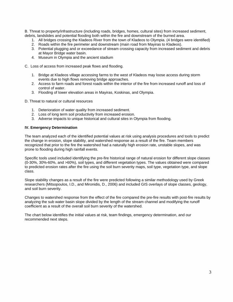
B. Threat to property/infrastructure (including roads, bridges, homes, cultural sites) from increased sediment, debris, landslides and potential flooding both within the fire and downstream of the burned area.
1. All bridges crossing the Kladeos River from the town of Kladeos to Olympia. (4 bridges were identified) 2. Roads within the fire perimeter and downstream (main road from Mayiras to Kladeos). 3. Potential plugging and or exceedance of stream crossing capacity from increased sediment and debris
at Mayor Bridge water basin. 4. Museum in Olympia and the ancient stadium
C. Loss of access from increased peak flows and flooding.
1. Bridge at Kladeos village accessing farms to the west of Kladeos may loose access during storm events due to high flows removing bridge approaches.
2. Access to farm roads and forest roads within the interior of the fire from increased runoff and loss of control of water.
3. Flooding of lower elevation areas in Mayiras, Koskinas, and Olympia. D. Threat to natural or cultural resources
1. Deterioration of water quality from increased sediment. 2. Loss of long term soil productivity from increased erosion. 3. Adverse impacts to unique historical and cultural sites in Olympia from flooding.
IV. Emergency Determination The team analyzed each of the identified potential values at risk using analysis procedures and tools to predict the change in erosion, slope stability, and watershed response as a result of the fire. Team members recognized that prior to the fire the watershed had a naturally high erosion rate, unstable slopes, and was prone to flooding during high rainfall events. Specific tools used included identifying the pre-fire historical range of natural erosion for different slope classes (0-30%, 30%-60%, and >60%), soil types, and different vegetation types. The values obtained were compared to predicted erosion rates after the fire using the soil burn severity maps, soil type, vegetation type, and slope class. Slope stability changes as a result of the fire were predicted following a similar methodology used by Greek researchers (Mitsopoulos, I.D., and Mironidis, D., 2006) and included GIS overlays of slope classes, geology, and soil burn severity. Changes to watershed response from the effect of the fire compared the pre-fire results with post-fire results by analyzing the sub water basin slope divided by the length of the stream channel and modifying the runoff coefficient as a result of the overall soil burn severity of the watershed. The chart below identifies the initial values at risk, team findings, emergency determination, and our recommended next steps.

4
Potential Value at Risk Findings Emergency
Determination Recommended Next steps
Threat to life/safety The villages of Pothos, Kladeos, Mayiras, and Koskinas appear to be located above high flood flows.
No emergency identified from initial review.
Determine likely storm event and model it to ensure villages are above potential flood flows. Consider placing rain gages in upper watershed to track rainfall and link to early warning system. Encourage homeowners to prepare for increased runoff and some flooding.
Threat to Property or Infrastructure (bridges)
The main bridges across the Kladeos River appear to have adequate capacity.
No emergency identified for storm flow capacity.
(Same as above)
Loss of access Earthen bridge approaches on the top crossing of the Kladeos River is at risk from eroding in large storm events. Smaller crossings that provide access to farms are undersized.
Yes, access may be temporarily lost during and after rain events due to increased sediment and undersized culverts.
Coordinate storm patrol before and after storm events to remove debris and restore access.
Threat to natural or cultural resources (A) Soils
Increased hillslope erosion in high soil burn severity areas will persist for 1-3 years depending on the vegetative recovery response.
No emergency to soil productivity since this is a fire dependent ecosystem and has naturally high erosion rates.
Treat high burn severity slopes (30-60%) in Olive factory and Mayor bridge sub water basin. Consider reforestation of steep slopes if natural reforestation is not adequate to help expedite slope stabilization.
(B) Water quality Increased sediment delivery to streams.
No emergency but anticipate temporary degradation of water quality.
1. Validate that no drinking water is obtained directly from the river. 2. Allow for natural vegetative recovery adjacent to streams to serve as sediment filter.
(C )Cultural resources Increase in peak flow and faster time to peak may increase frequency of flooding affecting downstream resources.
Conduct sediment and flow routing analysis for Kladeos and Alpheios rivers to evaluate river

5
response using various storm events.
Emergency Determination (continued) A. Assess threat to life or safety from landslides or flooding effects as a result of the fire using erosion estimates, sediment delivery increases to the streams, and landslide hazard analysis. Assessing the flood risk for the amount of rainfall required that would result in the following villages being placed at risk from flooding will require further analysis of rainfall data that was not available to the team (refer to section IV).
1. Village of Kladeos- at risk from landslides and flooding B. Threat to property/infrastructure (including roads, bridges, homes) from increased sediment, debris, landslides and potential flooding both within the fire and downstream of the burned area at these locations:
1. Top bridge (#4 in analysis) by the town of Kladeos may loose access from flooding and loss of earthen bridge approaches.
2. Concrete culvert at the Olive oil factory is undersized for the potential increase in flow. Current size is approximately 1 meter in diameter.
3. Main road to Kladeos has 3 stream crossings that may plug from bedload and debris. Initial review of culvert size indicates adequate capacity (exceedance of structure is not a concern) if the structure is free of debris.
4. Debris plugging and exceedance of streams crossing from increased sediment and debris at Mayor Bridge water basin.
C. Loss of access from increased peak flows and flooding at these locations:
1. Bridge at Kladeos village which provides access to farms west of Kladeos may be rendered non-
functional during storm events due to high flows removing bridge approaches. 2. Loss of access to farm roads and forest roads within the interior of the fire from increased runoff and
loss of control of water.
D Threat to natural or cultural resources includes:
1. Determination of potential adverse impacts to unique historical and cultural sites in Olympia from potential flooding requires sediment and flow routing analysis for both the Kladeos and Alpheos watersheds.
V. Potential Treatments and Follow-up Recommendations Field and office reviews indicate that the fire has created a watershed emergency in the two sub water basins identified as Mayor Bridge and Olive Factory. These sub-basins would be the priority areas for any treatments. The types of potential emergency could treatments include the following:
• Early warning systems strategically placed in the upper reaches of the watershed to detect rainfall to provide warning to residents of Kladeos. Warning systems can reduce the risk of loss of life by alerting residents to potential imminent flooding. Coordination between the Greek Department of Forestry and the Nomarchy on specific sites, locations, and actions to be taken before and after flooding needs to be included.
• Storm patrol – to maintain road access to farms and village. Use crews to remove debris and sediment
in front of road stream crossing structures (culverts and bridges) to reduce plugging potential. Key areas include the main road to Kladeos as well as valley roads within the burn interior. Storm patrol helps maintain access to farms and ensures that bridges and other crossings are clear of debris after storm events.

6
• Hillslope treatments – to reduce accelerated erosion. Current Greek practices use log erosion barriers
to trap sediment and to slow runoff by reducing the slope length. Log barriers may be used in high priority sub water basins above the olive oil factory and the Mayor’s bridge sub water basin. Both of these water basins have steep slopes and a large percentage of high and moderate soil burn severity. Log barriers may be effective, if appropriately spaced, and implemented along slopes between 30-60%.
• Hillslope treatment – to reduce accelerated erosion. Develop pilot area to test alternative treatments
that provide soil cover and reduce erosion. Treatments may include: applying organic material to provide effective soil cover to reduce erosion (possible sources may be farms); Leaving branches, pine needles and other organic material on the soil surface to provide cover and reduce erosion.
• Debris racks – may be used above bridges and stream crossings to trap debris that could potentially
plug bridges and culverts. Debris racks must be maintained after storm events to remove accumulated debris.
The team did not recommend any slope stability treatments for the area. The increased risk of landslides as a result of the fire may have downstream impacts. A coordinated Early warning system program should be explored to reduce any threat to human life. Deterioration of water quality as a result of increased sediment is likely to occur following storm events. Erosion and sediment delivery will be reduced over time as the vegetation rapidly recovers in the low and moderate severity burned areas. Resprouting of vegetation will foster recovery of steep slopes. Reforestation efforts may help to expedite ecosystem recovery.

7
APPENDIX A: BURNED AREA EMERGENCY RESPONSE TEAM, Greece 2007
MAYIRAS FIRE KLADEOS WATERSHED CASE STUDY
WATERSHED RESOURCE ASSESSMENT
Hydrology, Soils, Geology I. OBSERVATIONS
A. Background
1. Physiography The study area of the Kladeos watershed lies within the larger Alpheos River watershed. Elevation within the Kladeos watershed study area ranges from approximately 27 meters at the mouth of the Kladeos drainage near ancient Olympia, to over 600 meters near the village of Pothos in the top portion of the watershed. The Kladeos watershed is contained almost entirely within the perimeter of the Mayiras fire, which totaled approximately 52,000 hectares. Total area of the Kladeos watershed is approximately 3,600 hectares. Map 1 shows the location of the Kladeos watershed within the larger fire boundary.
2. Geology and Soils The Kladeos watershed is situated almost entirely within Neogene (Miocene-Pliocene) sediments with the headwater boundary lying near steep limestone cliffs located northeast of ancient Olympia (Map 2). The river flows to the west-southwest from the headwaters with the river discharging into the Alpheos River just downstream from this ancient city. The sedimentary bedrock is comprised of fluvial and lacustrine deposits.
Kronos (Kronios) Hill, situated just north of the ancient stadium is unstable, and archeological evidence of ancient instability includes retaining structures for stabilizing the hillslope. The stadium and ancient city are located on soils deposited from a combination of landslides from Kronos Hill and materials from the Kladeos and Alpheos Rivers. The potentially unstable materials are non-cohesive sands (e.g., SP, SM (ML), Unified Soil Classification) with small lenticular bodies of gravels (e.g., GM and GP, Unified Soil Classification) deposited by small streams. The gravel units form a small portion of the stratigraphic column in this area.
Outside of ancient Olympia the soils are mostly non-cohesive with isolated pockets of plastic silt (MH, Unified Soil Classification) and small lenticular bodies of gravels similar to those found within the ancient city area. According to the Soil Map of Greece (Greek Ministry of Agriculture Forest Service), the entire watershed is characterized by shallow to deep soils with low to moderate rill erosion risk on slopes ranging from gentle to moderately steep. Pre-fire vegetation in the upland slopes was generally Pinus halapensis in the south and north-facing slopes of the western and northern portions of the watershed, as well as along the southern watershed boundary. In areas that had burned within the past 10 years or so, vegetation consisted of shrubs and young pines. Much of the watershed consists of actively eroding slopes on which pre-fire vegetation was sparse and shrubby due to active soil movement preventing establishment of dense vegetative cover. Dominant vegetation along the Kladeos drainage in the 0-30% slope range was broadleaf shrubs and agriculture (olive, grapes, and fruit trees). Rock content is low overall. The clay loam soils in the eastern portion of the basin have low to moderate inherent erosion risk (the ease with which soil particles are detached and transported by wind and water). The sandy loam soils in the western half of the watershed have moderate to very high inherent erosion risk, even in the unburned condition. In both areas, on the steeper slopes (greater than about 60%) the erosion potential becomes high or very high.
8
3. Climate Weather data is available for towns in western Greece including Patra, Pyrgos, Kalamata, and Tripoli. The team selected Pyrgos due to its proximity to the case study area near Olympia. Meteorological data was obtained from the Hellenic National Meteorological Service via internet. Average annual precipitation in Pyrgos is 921 mm per year with 88 total days of rain. The precipitation data including monthly minimum and maximum temperatures, average monthly rainfall, and total days of rain per month was input into a program called Rock: Clime version 2005.06.07, developed by the USDA Forest Service, Rocky Mountain Research Station. (Visit (http://forest.moscowfsl.wsu.edu/fswepp for more information.) Temperature data for Pyrgos indicates a range from a maximum temperature of 42.4 to a low of -5.8 Celsius. Cooler months occur during the winter months (November thru April) with temperatures warming in May and June, and with July and August being the hottest months. Rainfall during June through August ranges from 4.5 to 14.7 mm over .7 to 1.9 days. The months from November through February have the highest precipitation with up to 190 mm of rain in December over approximately 13 days.
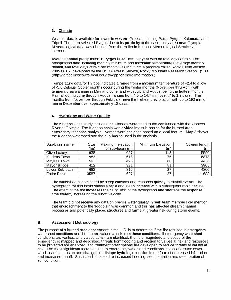
4. Hydrology and Water Quality The Kladeos Case study includes the Kladeos watershed to the confluence with the Alpheos River at Olympia. The Kladeos basin was divided into sub-basins for the burned area emergency response analysis. Names were assigned based on a local feature. Map 3 shows the Kladeos watershed and the sub-basins used in the analysis.
Sub-basin name Size (ha)
Maximum elevation of sub-basin (m)
Minimum Elevation (m)
Stream length(m)
Olive factory 938 627 118 5590Kladeos Town 983 618 76 6878 Mayiras Town 593 495 80 4438 Mayor Bridge 412 321 51 3905 Lower Sub-basin 662 319 27 4800 Entire Basin 3587 627 27 11,683
The watershed is dominated by steep canyons and responds quickly to rainfall events. The hydrograph for this basin shows a rapid and steep increase with a subsequent rapid decline. The effect of the fire increases the rising limb of the hydrograph and shortens the response time thereby increasing the runoff velocity. The team did not receive any data on pre-fire water quality. Greek team members did mention that encroachment to the floodplain was common and this has affected stream channel processes and potentially places structures and farms at greater risk during storm events.
B. Assessment Methodology The purpose of a burned area assessment in the U.S. is to determine if the fire resulted in emergency watershed conditions and if there are values at risk from these conditions. If emergency watershed conditions are verified, and values at risk are identified, then the magnitude and scope of the emergency is mapped and described, threats from flooding and erosion to values at risk and resources to be protected are analyzed, and treatment prescriptions are developed to reduce threats to values at risk. The most significant factor leading to emergency watershed conditions is loss of ground cover, which leads to erosion and changes in hillslope hydrologic function in the form of decreased infiltration and increased runoff. Such conditions lead to increased flooding, sedimentation and deterioration of soil condition.

9
Burned area evaluations included:
• Identifying fire-caused changes in soil properties and hydrologic function, which include:
o Spatial extent, strength, and depth of hydrophobic soils; o Amount and condition of remaining effective soil cover; o Infiltration rate; o Soil structural changes; o Loss of soil organic matter;
• Verifying and modifying the Burned Area Reflectance Classification (BARC) map to create a soil burn severity map;
• Identifying sediment source areas and erosion potential; • Identifying potential flood source areas; • Identifying potential debris flow source and deposition areas; • Determining current channel and culvert conditions; • Determining channel and culvert capacities; • Identifying potential inundation areas; and • Identifying potential threats to human life, property, and critical natural and
cultural resources (values at risk).
The BAER Team conducted field reconnaissance on foot and by car to review resource conditions after the fire. The main objectives of the field visits were to 1) evaluate soil conditions as indicators of soil burn severity and watershed response in order to identify potential flood and erosion source areas; 2) identify and inventory potential values at risk, 3) identify the physical and biological mechanisms that are creating risks; 4) review channel morphology and riparian conditions; 5) inspect hillslope conditions; and 6) determine needs for emergency stabilization. Potential values at risk are human life and property, and critical natural and cultural resources located within or downstream of the fire that may be subject to damage from flooding, ash, mud and debris deposition, and hillslope erosion.

10
1. Soil Burn Severity
Soil burn severity is not the same concept as fire intensity and fire severity as recognized by fire behavior specialists or vegetation specialists, nor is it the same as vegetation mortality. Fire intensity and fire severity relate to fire behavior and fire effects on overstory vegetation and ground fuels, respectively while soil burn severity relates specifically to effects of the fire on soil conditions (e.g., amount of surface litter and duff, infiltration rate, erodibility, soil structure). Although soil burn severity is not based primarily on fire effects on vegetation, we do use post-fire vegetative conditions and pre-fire vegetation density as some of the indicators in visually assessing soil burn severity, and are among the primary factors affecting post-fire spectral response upon which the Burned Area Reflectance Classification (BARC) classification algorithm is based. In combination with field observations of actual soil conditions, a soil burn severity map is produced by adjusting the BARC map as necessary.
Table 1. Definitions of Terms Commonly used in Soil and Watershed Burned Area Assessments.
Term Definition Fire Intensity
Rating based on temperature, flame length, rate of spread, heat of combustion and total amount and size of fuel consumed. Accounts for convective heat rising into the atmosphere and fire effects to the overstory.
Fire Severity
Rating based on temperature, moisture content of duff and fuels lying on the ground, heat of combustion of conductive and radiant heat penetrating into the soil and affecting soil characteristics.
Soil Burn Severity
Rating of fire impacts on soil productivity and erosion rate, and the potential for vegetation recovery. Burn severity is delineated on maps as polygons. Classes of burn severity are High, Moderate, Low and Unburned to Very Low.
Watershed Response
A qualitative evaluation of the amount of soil cover; amount and distribution of impermeable surfaces (rock outcrop, hydrophobic soils), and canopy conditions. Classes of watershed response are High, Moderate and Low.
X-year Storm Event
Rainfall occurring with a specific probability (1 in X chance) based on historical data. For example, the 10-year storm has a 1 in 10 (10%) chance of occurring in any given year, while the 100-year storm has a 1 in 100 (1%) chance of occurring in any given year.
X-year Flood
Stream discharge with a specific probability of occurring (1 in X chance) based on historical data. The 100-year flood may or may not occur as a result of a 100-year rainfall; the two are independent.
In some cases, there may be complete consumption of vegetation by fire, with little effect on soil properties. In general, dense pre-fire vegetation with a deep litter and duff layer results in longer heat residence time (the amount of time the heat is in contact with the soil), hence more severe effects on soil properties. For example, deep ash after a fire usually indicates a deeper litter and duff layer prior to the fire, which generally supports longer residence times. Increased residence time promotes the complete loss of effective soil cover, formation of a water repellent layer at or near the soil surface, loss of soil organic matter, and loss of soil structural stability. The results are increased runoff and soil particle detachment by water and wind, and transport off-site. Soil burn severity parameters include changes in litter and duff, loss of soil structure, destruction of fine and very fine roots in the surface horizon, and development of hydrophobic (water repellent) soil surfaces. Changes in litter/duff conditions as affected by the fire were noted and compared to pre-fire conditions. Water repellency was evaluated by determining if water repellency was present, and if so, the depth and thickness of the water repellent layer were noted. Mapping Soil Burn Severity A Burned Area Reflectance Classification (BARC) is a satellite image-derived map of post-fire changes in spectral reflectance. The BARC is created by comparing near infrared and shortwave infrared reflectance values and measuring the difference between pre-fire and post-

11
fire condition (visit http://www.fs.fed.us/eng/rsac/baer/barc.html for more information). Map 4 displays pre-fire and post-fire Landsat images of the Kladeos watershed. For the Greece 2007 fires, Landsat 5 and 7 Thematic Mappers (TM) was used. For the Mayiras fire and the Kladeos watershed, the pre-fire image was acquired September 1, 2003. The post-fire image was acquired on September 4, 2007, soon after the fire stopped spreading. The imagery was obtained by the U.S. Geological Survey Earth Resources Observation and Science (EROS) center in Sioux Falls, South Dakota, and processed and analyzed by the U.S. Forest Service Remote Sensing Applications Center (RSAC) in Salt Lake City, Utah.
Note: The U.S. team members worked with EROS and RSAC after the initial visit to Greece in September 2007 to acquire pre- and post-fire imagery for all of the August 2007 wild fires in Greece. The exception was the large fire at the southeast area of Evia, since a clear post-fire image could not be obtained during that first week following the first team’s visit. Once the pre- and post-fire imagery was obtained, remote sensing specialists at RSAC used a Differenced Normalized Burn Ratio algorithm to develop thematic maps of burn severity for all the Greece August 2007 wildfires. (Key, C., and Benson, N. 2006) These files were delivered on DVD, along with other spatial datasets used in this assessment, to the four Greek Forest Service team members.
In the U.S., the BAER assessment and recommendations must be completed within 7 days of containment of the fire. Therefore it is important to acquire a post-fire image as early as possible. Because of this, post-fire image quality is not always optimal and may contain clouds. This was the case with the image of the Mayiras fire, obtained on September 4, 2007. The BARC was evaluated by field visits to verify that the soil burn severity classes depicted accurately reflected ground conditions. In nearly a third of the Kladeos watershed, clouds obscured the immediate post-fire satellite image, and these areas were mapping in by hand based on field observations by team members. We observed that in the areas where clouds did not obscure the image, the BARC was a reasonable depiction of distribution and extent of soil burn severity classes observed in the watershed. Map 5 shows the distribution of the soil burn severity classes in the Kladeos watershed. The soil burn severity map was used in the rapid assessment to evaluate post-fire erosion rates and runoff potential, as well as in identifying changes in slope stability as a result of the fire. If this map is to be used in long-term ecosystem recovery planning or monitoring, more extensive ground verification is recommended. Management agencies may want to consider obtaining post-fire satellite imagery from a later date that is cloud-free. This will also enable the development of a more accurate vegetation mortality map for these other uses.
2. Soil Erosion Fire effects were evaluated based on changes in litter and duff (ground cover), destruction of fine and very fine roots in the surface horizon, loss of soil structure and increased susceptibility to erosion, and development of hydrophobic (water repellent) soil surfaces. Water repellency was evaluated by observing the depth and thickness of a water repellent horizon in surface soils where it existed, and the length of time a water drop remained beaded on the surface. Soils maps were obtained from the internet from the Soils Geographical Database of Europe (http://eusoils.jrc.it/esbn/SGDBE.html) and from officials in the Greek Forest Service (Georgior Amestis, Hydrology Section Leader, Athens). Pre- and post-fire erosion potential was estimated using the Erosion Risk Management Tool (ERMiT), an internet-based erosion modeling tool developed by the U.S. Forest Service (http://forest.moscowfsl.wsu.edu/fswepp). This tool was developed for post-fire rapid assessments of erosion potential, and is based on the Watershed Erosion Prediction Program (WEPP), an internet-based erosion model. These models are based on extensive research and validation in the U.S. and should be further explored for use in Greece. However, since western Greece is similar in climate, topography, and vegetation types to California in the U.S., we can assume, for this analysis, that the model is a reasonable predictor of erosion in the burned area. A California climate input with similar precipitation, temperature, and number of rain days was selected, and modified using local climate data from the Pyrgos weather stations. Pre and post-fire erosion rates were obtained using by running the ERMiT tool repeatedly, using different combinations of parameters each time. The following input parameters were used, in varying combinations to represent the conditions in the watershed as determined by GIS spatial overlays of soils, slope, vegetation, and soil burn severity.

12
• Soil texture (clay loam and sandy loam)
• Slope class ( 0-30, 30-60, and greater than 60)
• Pre-fire vegetation class ( forest, shrub, and agricultural lands)
• Slope length 150 and 300 meters
• Soil burn severity classes Unburned, Low, Moderate, High Erosion prediction results in kg/hectare were compared for pre- and post-fire conditions, using the soil burn severity map. Modeled erosion rates values rely on site specific factors, especially the size of the storm event that occurs, and provide a relative comparison of pre- and post-fire values rather than actual erosion rates. 3. Watershed Response On-the-ground field observations within and downstream of the burned area were conducted to determine watershed response that could affect potential values at risk within and downstream of the burned area. Channel morphology related to transport and deposition processes were noted, along with channel crossings and stream outlets. Observations included condition of riparian vegetation and the volume of sediment stored in channels and on slopes that could be mobilized. Soil burn severity and changes in soil infiltration were also considered. The major determining factor influencing runoff and erosion from burned hillslopes is the amount of disturbance to the forest floor that protects the underlying mineral soil (Robichaud 2000). The unburned forest floor consists of a litter layer (leaves, needles, fine twigs, bark flakes, matted dead grass, mosses and lichens, O1 soil horizon) and a duff layer (partially decomposed remnants of the material in the litter layer, O2 soil horizon) (Martin and Moody 2001). These layers absorb most of the rainfall, provide storage of water and obstruct the flow of water on hillslopes. The combustion process converts the forest floor into ash and charcoal. Infiltration is often decreased as a result of soil surface sealing by ash and fine particles, as well as hydrophobicity (water repellency) caused by volatilization of wax compounds in the vegetation and litter. Runoff and energy for erosion is often increased. When the charcoal and ash are removed from the hillslope by post-fire runoff or wind, the soil is left bare and susceptible to rain splash and overland flow. The amount of forest floor cover is dependant on the density of the vegetation. In general, hydrophobicity is broken up or is sufficiently washed away within one to two years after a fire (Robichaud, 2000).
Overland flow occurs as a result of rainfall that exceeds soil infiltration capacity and the storage capacity of depressions. On the unburned forest floor, overland flow often doesn’t occur at all and when it does it follows a myriad of interlinking flow paths that constantly change as organic material (litter and duff layers) and inorganic material (rock) are encountered. Consumption of the forest floor by fire alters the path of overland flow by reducing the overall length of the flow path, resulting in the concentration of flow into a shorter flow path. This concentration of overland flow increases the hydraulic energy of the flow and can result in rill erosion. At the watershed scale, the loss of protective soil cover, the decreased infiltration and the formation of rills that have a high water conveyance capacity all act to reduce the time of concentration or the amount of time for overland flow to reach a defined point within the watershed. Increases in runoff also correlate to increased streamflow discharge. Factors that watershed managers consider in analyzing the streamflow discharge response of a burned watershed include changes in discharge, peak flows, timing of flow, and baseflow (DeBano, 1998)
4. Geology
The methodology applied in this geological analysis included the following: a. Review of existing geological information was completed prior to any field work. This
included a geology map from the Russian Geological Survey (reference unavailable) and a book on Greek geology compiled by Higgins and Higgins (1996).
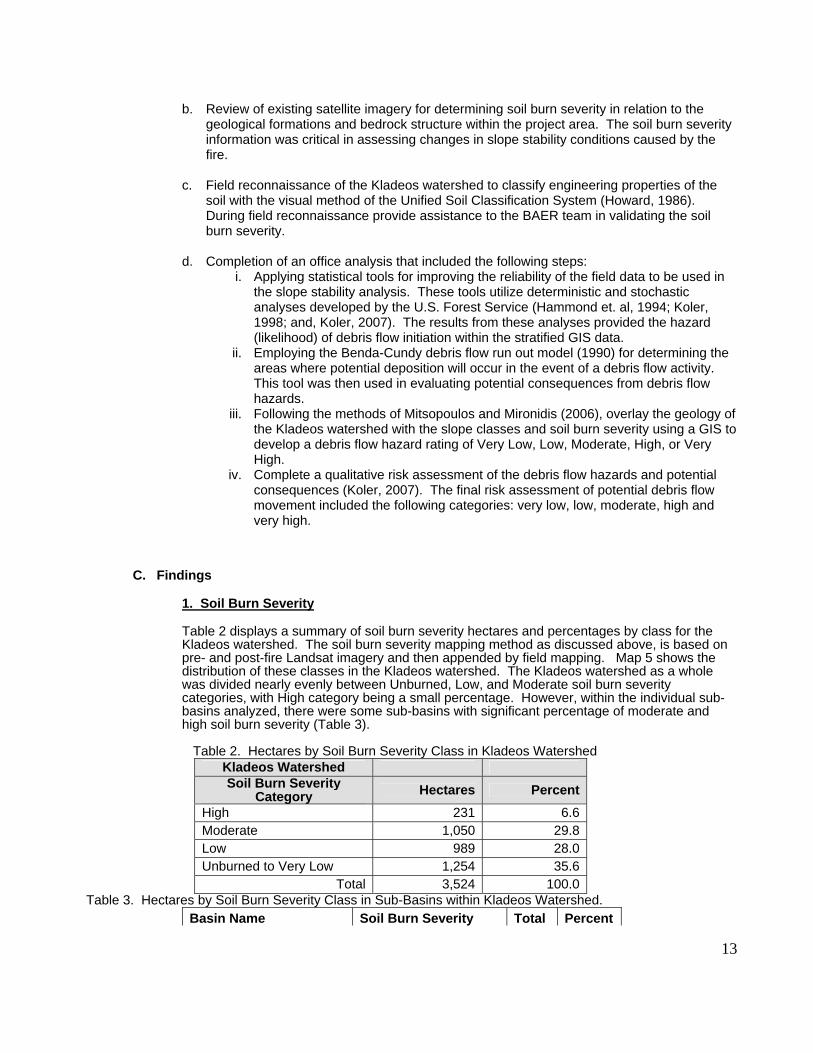
13
b. Review of existing satellite imagery for determining soil burn severity in relation to the
geological formations and bedrock structure within the project area. The soil burn severity information was critical in assessing changes in slope stability conditions caused by the fire.
c. Field reconnaissance of the Kladeos watershed to classify engineering properties of the
soil with the visual method of the Unified Soil Classification System (Howard, 1986). During field reconnaissance provide assistance to the BAER team in validating the soil burn severity.
d. Completion of an office analysis that included the following steps:
i. Applying statistical tools for improving the reliability of the field data to be used in the slope stability analysis. These tools utilize deterministic and stochastic analyses developed by the U.S. Forest Service (Hammond et. al, 1994; Koler, 1998; and, Koler, 2007). The results from these analyses provided the hazard (likelihood) of debris flow initiation within the stratified GIS data.
ii. Employing the Benda-Cundy debris flow run out model (1990) for determining the areas where potential deposition will occur in the event of a debris flow activity. This tool was then used in evaluating potential consequences from debris flow hazards.
iii. Following the methods of Mitsopoulos and Mironidis (2006), overlay the geology of the Kladeos watershed with the slope classes and soil burn severity using a GIS to develop a debris flow hazard rating of Very Low, Low, Moderate, High, or Very High.
iv. Complete a qualitative risk assessment of the debris flow hazards and potential consequences (Koler, 2007). The final risk assessment of potential debris flow movement included the following categories: very low, low, moderate, high and very high.
C. Findings
1. Soil Burn Severity
Table 2 displays a summary of soil burn severity hectares and percentages by class for the Kladeos watershed. The soil burn severity mapping method as discussed above, is based on pre- and post-fire Landsat imagery and then appended by field mapping. Map 5 shows the distribution of these classes in the Kladeos watershed. The Kladeos watershed as a whole was divided nearly evenly between Unburned, Low, and Moderate soil burn severity categories, with High category being a small percentage. However, within the individual sub-basins analyzed, there were some sub-basins with significant percentage of moderate and high soil burn severity (Table 3). Table 2. Hectares by Soil Burn Severity Class in Kladeos Watershed
Kladeos Watershed Soil Burn Severity
Category Hectares Percent High 231 6.6 Moderate 1,050 29.8 Low 989 28.0 Unburned to Very Low 1,254 35.6
Total 3,524 100.0 Table 3. Hectares by Soil Burn Severity Class in Sub-Basins within Kladeos Watershed.
Basin Name Soil Burn Severity Total Percent

14
Kladeos Town Sub-Basin Unburned 380 38.7 Low 382 38.8 Moderate 210 21.3 High 10 1.1
Outside of Fire Perimeter 1 0.1
Kladeos Town Sub-Basin Total 982 100.0 Mayiras Town Sub-Basin Unburned 103 17.4 Low 251 42.4 Moderate 222 37.5 High 16 2.6
Outside of Fire Perimeter 0 0.1
Mayiras Town Sub-Basin Total 593 100.0 Mayor Bridge Sub-Basin Unburned 71 17.2 Low 79 19.1 Moderate 186 45.2 High 76 18.4
Outside of Fire Perimeter 0 0.1
Mayor Bridge Sub-Basin Total 412 100.0 Olive Factory Basin Unburned 483 51.6 Low 142 15.1 Moderate 209 22.2 High 75 8.0
Outside of Fire Perimeter 29 3.1
Olive Factory Basin Total 938 100.0 Lower Sub-Basin Unburned 216 32.6 Low 135 20.4 Moderate 223 33.7 High 55 8.3
Outside of Fire Perimeter 33 5.0
Lower Sub-Basin Total 662 100.0 Grand Total 3,587
The areas of high soil burn severity tended to occur in areas where pre-fire fuels had been dense, such as dense stands of Pinus halepensis or hardwood. The areas of moderate soil burn severity tended to occur in areas of shrub lands or where pine foliage was scorched but not consumed. Areas of low soil burn severity occurred in areas where pre-fire vegetation consisted of grasses and light shrubs, or sparse vegetation. Pockets of unburned vegetation are distributed throughout the burned area. The following table presents a brief representative concept of the soil burn severity classes and field indicators in the Kladeos watershed.
Table 4. Soil Burn Severity Class Characteristics in the Kladeos Watershed

15
Soil Burn Severity Characteristics
Unburned to Very Low
Unburned areas within the fire perimeter, and areas where very low severity ground fire may have occurred. Vegetation canopy, ground cover, and soil characteristics are not altered from pre-fire conditions. Thin layer of water repellency may be found under vegetation.
Low
Shrub canopy and grasses may be scorched or consumed. Trees may be scorched but are not consumed, and generally still viable. Unburned or charred, but recognizable, grasses and shrub litter present at the surface. A moderate, thin water repellent layer may be present at the ash-soil interface, under or near vegetation clumps.
Moderate
Shrub canopy consumed, with stems and some branches remaining. Tree may or may not be killed, but the canopy is generally scorched but not consumed; needles and leaves will fall to the ground to provide soil cover. Unburned and recognizable charred leaf litter and twigs remain within a very thin ash layer in shrub areas; a moderate to strong but thin water repellent layer is present but discontinuous under trees and shrubs.
High
Generally areas where pre-fire tree stands were dense (generally greater than about 60-80 percent) and pre-fire litter layer was more continuous but is now consumed. Some charred, but recognizable organic material may be present in or beneath ash layer. Very little effective soil cover and little or no potential for needle and leaf fall to provide soil cover due to consumption of canopy. Discontinuous, moderate thin water repellency in surface 1-2 cm of mineral soil.
2. Erosion Potential Erosion and runoff potential in the burned area was increased significantly in the areas of high and moderate soil burn severity due primarily to loss of effective soil cover and in some areas, formation of patches of thin water repellant soil surfaces. Map 6 illustrates the change in erosion following the fire.
The results of the WEPP/ERMiT erosion model indicated an increase in tons per hectare sediment delivery for each sub-basin of nearly double, as a result of the fire. Table 5 shows expected erosion in kg/hectare predicted by the model in the event of a 10 year storm (10% chance of occurrence) under both pre-fire and post-fire conditions. For reference, one millimeter over a hectare, given an average bulk density of 1.3 grams/ cm3, will weigh approximately 13 tons. Generally shallow soils and soils with a root restricting subsoil layer have lower allowable soil loss tolerances than deep soils, in order to maintain site productivity. Of course, surface erosion occurs primarily as rill erosion and will not in actuality be evenly distributed over the surface of the ground. Some areas will lose much more soil than others.

16
Table 5. Comparison of Average Pre-Fire and Post-Fire Erosion Rates
Average Kg/Ha
Average Kg/Ha
Basin Name PRE-FIRE POST-FIRE Kladeos_Town 26 49Mayiris_Basin 25 46Mayor_Bridge 28 52Olive_Factory_Basin 25 47Lower Sub-Basin 36 63
3. Watershed Response Peak flow response is expected to increase in the Kladeos water basin during intense, short-duration rainfall inputs due to lack of vegetation and slope steepness. The following chart indicates that each sub-basin will respond to rainfall inputs faster as a result of the fire, because the basin’s Time of Concentration (Tc) is shortened. Base flow levels are also anticipated to increase as is typical in post-fire watersheds (DeBano, 1998)
The primary watershed response of this fire is expected to include: 1) an initial flush of ash and vegetation debris; and 2) localized sediment deposition. Post-fire runoff, peak flows, and sediment delivery from rainfall driven storms are expected to increase over pre-fire levels. The table above illustrates how as vegetative cover is removed from the watershed, runoff increases in both frequency and velocity. Sub-basins of particular concern to flash flooding include the Olive Factory, Mayor Bridge and Mayiras town. Field observations indicate the peak flows are generally expected to stay within existing stream channels with the exception of the Olive Factory sub-basin where a small 1 meter culvert was identified at the base of the watershed. Culvert plugging from sediment and debris is anticipated in the smaller crossings which lack adequate capacity.. Several new culverts that have been placed to provide farm access may be in jeopardy if not routinely cleared of debris during and following storms. Most of the farm access crossings are undersized for the amount of streamflow, bedload and debris that is expected as a result of the fire. Vegetation recovery is largely dependant on climatic cycles. If wet winters occur, vegetation recovery could be rapid. Brush species are currently resprouting and in other areas grasses can be seen. Once sprouting vegetation begins to produce brush crowns and a duff/litter layer, watershed response will begin to return to normal (slower response). However, if winters are dry, vegetation recovery will be slow, and thus the establishment of ground cover and shrub and tree communities will be slow, and watershed response will remain slightly elevated over pre-fire conditions. 4. Geology
Slope Stability Analysis Realistic input parameter values were taken from such available resources as field
Sub-basin Pre-fire –Runoff response time (Tc)
Post-fire runoff response time (Tc)
Pre-fire Runoff velocity km/hr
Post-fire runoff velocity km/hr
Olive Factory 1.9 hrs 1.36 hrs 2.8 4.0 Kladeos Town 2.4 hrs 1.6 hrs 2.9 4.1 Mayiras Town 1.7 hrs 1.2 hrs 2.5 3.6 Mayor Bridge 1.9 hrs 1.3 hrs 2.1 2.9 Lower Subdivision
2.1 hrs 1.4 hrs 2.3 3.3
Entire Basin 3.5 hrs 2.4 hrs 3.4 4.8

17
reconnaissance data, soil inventories, landslide inventories, maps for the study area. Where there were gaps in this information, a level of confidence was established for the data that will fill these gaps, based on local knowledge and field observations. The tool applied in this analysis is the Level I Stability Analysis (LISA) developed by the U.S. Forest Service (Hammond et al., 1994). Figures and tables in the LISA guide suggest values for each of the variables or relationships. The spatial distribution of values being evaluated is important in completing a sensitivity analysis. Usually, concave, gentle slopes have deeper soils than do convex, steep slopes; soil depth on planar slopes is somewhere between. Areas of tree mortality from wildfire, insect infestation, disease, and timber harvesting influence the spatial distribution of tree root strength and tree surcharge. For the Kladeos water basin a worst case scenario was assumed in which areas where a high soil burn severity occurred the result was a total loss of vegetation including viable root systems. As with other similar projects, the values within the infinite slope equation vary widely. Therefore the study area was divided into polygons where variable distribution of values are spatially similar. For the Kladeos case study the spatial divisions were made by dividing the watershed by sub-basins and by slope class (e.g., 0% to 30%, 31% to 60%, and 61% and greater). The rationale in this spatial delineation is that the underlying geological formation is somewhat uniform from one sub-basin to the next. In other words, the Neogene materials are dominated by silty sands or silty sands with clay (SM or SM (ML or MH)) across sub-basins – and therefore the engineering properties are very similar. Since the two critical parameters in a slope stability analysis are slope and ground water (Hammond et al., 1994; Koler, 1998), slope was applied in the first deterministic analysis to obtain the critical soil depths when the slopes are in equilibrium (i.e., driving forces are equal to the resisting forces). Table 6 shows results from a deterministic analysis to obtain critical soil depths for the Kladeos basin using statistical averages of the physical properties (e.g., average friction angle, φ, is 29º). The second deterministic analysis focused on ground water (i.e., depth of ground water to total soil depth). Results from this step are portrayed in Tables 7, 8 and 9 for 3-ft, 5-ft, and 10-ft deep soils. The final step then is the stochastic analysis. The results of which are summarized by sub-basin below.
Table 6: Critical soil depths (depths where driving forces = resisting forces) using deterministic Level I stability analysis (after Hammond et al., 1994; Koler, 1998; Koler, 2007). Soil depths are in feet.
Condition Ground Water Ratio
Slope Angle
SM(ML)
30% (17º)
40% (22º)
50% (27º)
60% (31º)
70% (35º)
80% (39º)
90% (42º)
100%(45º)
q0 = 0 psf 0.0 >15.0 >15.0 >15.0 2.9 1.1 0.7 0.6 0.5 Cr = 0 psf 0.1 >15.0 >15.0 >15.0 1.7 0.8 0.6 0.5 0.4 φ = 29º 0.2 >15.0 >15.0 6.6 1.2 0.7 0.5 0.4 0.4 Cs = 10 psf 0.3 >15.0 >15.0 2.4 0.9 0.6 0.5 0.4 0.4 γd = 80 pcf 0.4 >15.0 >15.0 1.5 0.7 0.5 0.4 0.4 0.3 w = 17% 0.5 >15.0 7.4 1.1 0.6 0.5 0.4 0.3 0.3 0.6 >15.0 2.5 0.8 0.5 0.4 0.4 0.3 0.3 0.7 >15.0 1.5 0.7 0.5 0.4 0.3 0.3 0.3 0.8 >15.0 1.1 0.6 0.4 0.3 0.3 0.3 0.3 0.9 3.5 0.8 0.5 0.4 0.3 0.3 0.3 0.3 1.0 1.8 0.7 0.4 0.3 0.3 0.3 0.3 0.2
Note: q0 = tree surcharge, Cr = root cohesion, φ = angle of internal friction, Cs = soil cohesion, γd = dry soil unit weight, w = moisture content
Table 7: Ground water ratios for 3-ft deep soils with the same physical properties in Table 6.
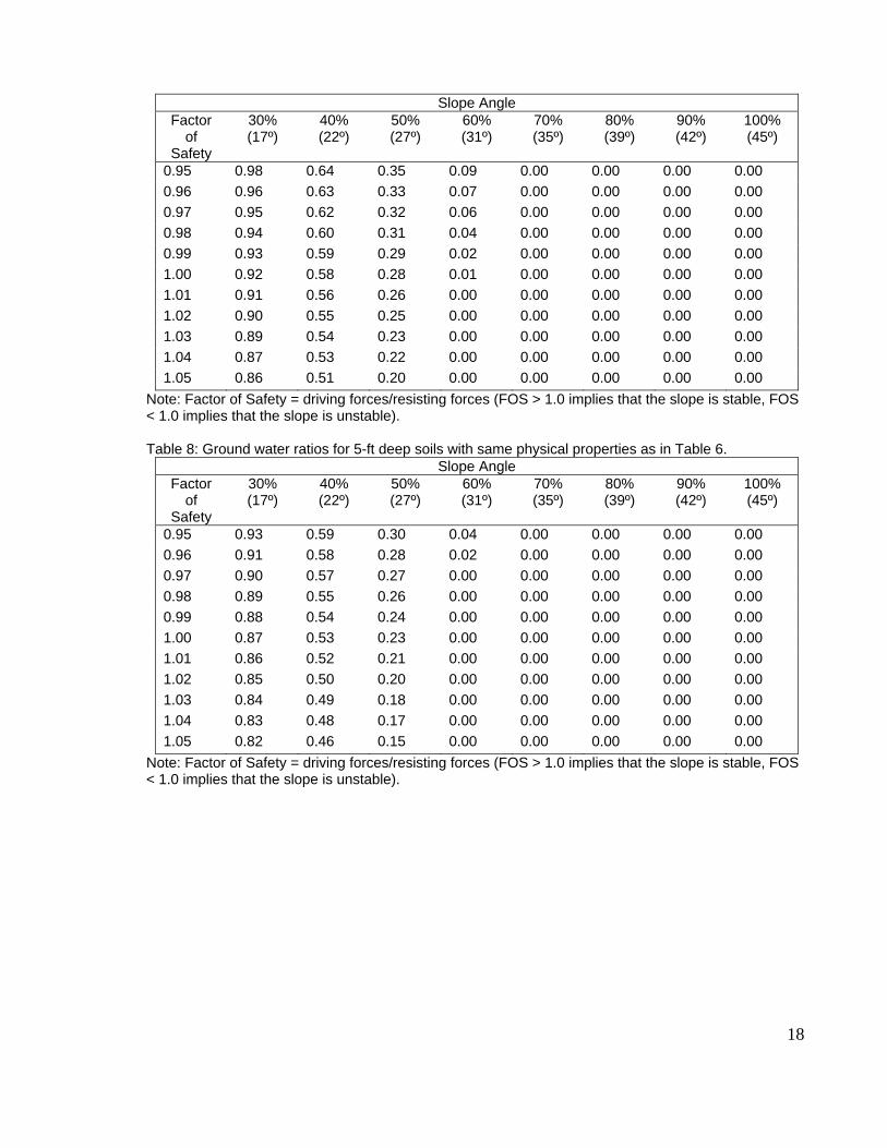
18
Slope Angle Factor
of Safety
30% (17º)
40% (22º)
50% (27º)
60% (31º)
70% (35º)
80% (39º)
90% (42º)
100% (45º)
0.95 0.98 0.64 0.35 0.09 0.00 0.00 0.00 0.00 0.96 0.96 0.63 0.33 0.07 0.00 0.00 0.00 0.00 0.97 0.95 0.62 0.32 0.06 0.00 0.00 0.00 0.00 0.98 0.94 0.60 0.31 0.04 0.00 0.00 0.00 0.00 0.99 0.93 0.59 0.29 0.02 0.00 0.00 0.00 0.00 1.00 0.92 0.58 0.28 0.01 0.00 0.00 0.00 0.00 1.01 0.91 0.56 0.26 0.00 0.00 0.00 0.00 0.00 1.02 0.90 0.55 0.25 0.00 0.00 0.00 0.00 0.00 1.03 0.89 0.54 0.23 0.00 0.00 0.00 0.00 0.00 1.04 0.87 0.53 0.22 0.00 0.00 0.00 0.00 0.00 1.05 0.86 0.51 0.20 0.00 0.00 0.00 0.00 0.00
Note: Factor of Safety = driving forces/resisting forces (FOS > 1.0 implies that the slope is stable, FOS < 1.0 implies that the slope is unstable).
Table 8: Ground water ratios for 5-ft deep soils with same physical properties as in Table 6.
Slope Angle Factor
of Safety
30% (17º)
40% (22º)
50% (27º)
60% (31º)
70% (35º)
80% (39º)
90% (42º)
100% (45º)
0.95 0.93 0.59 0.30 0.04 0.00 0.00 0.00 0.00 0.96 0.91 0.58 0.28 0.02 0.00 0.00 0.00 0.00 0.97 0.90 0.57 0.27 0.00 0.00 0.00 0.00 0.00 0.98 0.89 0.55 0.26 0.00 0.00 0.00 0.00 0.00 0.99 0.88 0.54 0.24 0.00 0.00 0.00 0.00 0.00 1.00 0.87 0.53 0.23 0.00 0.00 0.00 0.00 0.00 1.01 0.86 0.52 0.21 0.00 0.00 0.00 0.00 0.00 1.02 0.85 0.50 0.20 0.00 0.00 0.00 0.00 0.00 1.03 0.84 0.49 0.18 0.00 0.00 0.00 0.00 0.00 1.04 0.83 0.48 0.17 0.00 0.00 0.00 0.00 0.00 1.05 0.82 0.46 0.15 0.00 0.00 0.00 0.00 0.00
Note: Factor of Safety = driving forces/resisting forces (FOS > 1.0 implies that the slope is stable, FOS < 1.0 implies that the slope is unstable).

19
Table 9: Ground water ratios for 10-ft deep soils with same physical properties in Table 6. Slope Angle
Factor of
Safety
30% (17º)
40% (22º)
50% (27º)
60% (31º)
70% (35º)
80% (39º)
90% (42º)
100% (45º)
0.95 0.89 0.56 0.26 0.00 0.00 0.00 0.00 0.00 0.96 0.88 0.54 0.25 0.00 0.00 0.00 0.00 0.00 0.97 0.87 0.53 0.23 0.00 0.00 0.00 0.00 0.00 0.98 0.86 0.52 0.22 0.00 0.00 0.00 0.00 0.00 0.99 0.84 0.50 0.20 0.00 0.00 0.00 0.00 0.00 1.00 0.83 0.49 0.19 0.00 0.00 0.00 0.00 0.00 1.01 0.82 0.48 0.17 0.00 0.00 0.00 0.00 0.00 1.02 0.81 0.47 0.16 0.00 0.00 0.00 0.00 0.00 1.03 0.80 0.45 0.15 0.00 0.00 0.00 0.00 0.00 1.04 0.79 0.44 0.13 0.00 0.00 0.00 0.00 0.00 1.05 0.78 0.43 0.12 0.00 0.00 0.00 0.00 0.00
Note: Factor of Safety = driving forces/resisting forces (FOS > 1.0 implies that the slope is stable, FOS < 1.0 implies that the slope is unstable).
Debris flow hazards have been a common geologic hazard in the Kladeos River basin for millennia. Debris flows have been initiated over recent geologic time by the loss of vegetation, climatic conditions and earthquake events. Results of the Benda-Cundy debris flow run-out model indicates that a considerable percentage (approximately 95%) of debris flow deposition occurs within the lower sub-basin and in the Alpheos River basin. Some materials are deposited where the tributaries enter the main stem of the sub-basins at a 70º to 90º angle or where the stream gradient drops to less than 5%. Table 10 shows the pre-fire hazard conditions in which a majority of the Kladeos River basin has low debris flow hazard ratings and no very high debris flow hazard ratings. Only 5% or less of the sub-basins have a high hazard rating. Table 11 shows the post-fire hazard conditions, and here there is a significant change with a drop in the low hazard rating and an increase in high and very high hazard ratings. The Mayor Bridge sub-basin has the highest increase by a factor of 8 for the high hazard rating and is clearly the most sensitive sub-basin to debris flow activities. The Olive Factory and Mayiris Town sub-basins have the next highest increase by a factor of 3 followed by the Kladeos Town sub-basin with an increase by a factor of 2.
Table 10: Debris flow hazard ratings by sub-basin in pre-fire conditions. Numerical values have been rounded to whole integers.
Sub-Basin Size (ha)
L (ha)
% of Basin
M (ha)
% of Basin
H (ha)
% of Basin
VH (ha)
% of Basin
Kladeos Town 986 622 63 308 31 52 5 0 0 Mayiris Basin 593 395 67 176 30 21 4 0 0 Mayor Bridge 413 279 68 121 29 11 3 0 0 Olive Factory 941 578 61 312 33 48 5 0 0
Lower Sub-Basin
652
--
--
--
--
--
--
--
--

20
Table 11: Debris flow hazard ratings by sub-basin in post-fire conditions. Numerical values have been rounded to whole integers.
Sub-Basin Size (ha)
L (ha)
% of Basin
M (ha)
% of Basin
H (ha)
% of Basin
VH (ha)
% of Basin
Kladeos Town 986 510 52 337 34 108 11 26 3 Mayiris Basin 593 236 40 262 44 87 15 7 1 Mayor Bridge 413 120 29 185 45 98 24 8 2 Olive Factory 941 412 44 378 40 127 14 20 2
Lower Sub-Basin
652
--
--
--
--
--
--
--
--
Table 10 displays the derivation of debris flow risk by the hazard (likelihood) and consequences for pre-fire conditions and Table 11 gives the post-fire risk. Debris flow movement and deposition within the lower sub-basin are the consequences of concern because of the potential threat to archeological sites, bridges, roads, and homes. An estimate of the worst case consequence is that extensive damage can and may occur resulting in significant stabilization (i.e., major consequences). Therefore for post-fire conditions the risk value for the very high hazards (e.g., almost certain likelihood) is very high; and, the risk value for the high hazards (e.g., likely likelihood) is high; the risk value for moderate hazards (e.g., possible likelihood) is also high; and, the risk value for the low hazards (e.g., unlikely likelihood) is moderate.
The Kladeos River basin has been and continues to be an active debris flow watershed (Table 10) even under pre-fire conditions. For post-fire conditions the debris flow risk values range from moderate to high and very high. The sub-basins with the largest percentage by area with high and very high risk values are in descending order: Mayor Bridge (71%), Mayiras Basin (60%), Olive Factory (56%) and Kladeos Town (48%). There are no short-term mitigation options other than an early warning system. Possible option for the long-term may include strategically placed sediment basins and debris flow deflectors (structures to push the debris flow materials away from the channel). Re-establishing vegetation will be very important so that ground water can be withdrawn through evapotranspiration and thereby lowered. This, however, will probably require several years of effort.
Results from the analyses described in Section B above were applied in a final qualitative risk assessment using a matrix of slope, underlying geology, vegetation, and soil burn severity to assign a slope stability hazard rating. These hazard and consequence ratings are displayed below in Table 12. In the unburned areas the hazard (likelihood) values ranged from rare to likely and all consequences were deemed moderate. In the burned areas, however, the hazard (likelihood) values were increased by one level (see spreadsheet and table) due to a predicted increase in ground water rise and subsequent failure due to the loss of vegetation and evapotranspiration. Map 7 displays the spatial distribution of the pre-fire and post-fire slope stability hazard (likelihood of failure) categories.

21
Table 12. Slope Stability Hazard (Liklihood of failure) Class
Slope Pre-Fire Veg
Pre-Fire Slope Stability Hazard Class
Soil Burn Severity
Post-Fire Slope Stability Hazard Class
0-30% Any Low Unburned Low 0-30% Any Low Low Low 0-30% Any Low Moderate Low 0-30% Any Low High Moderate 30-60% Any Moderate Unburned Moderate 30-60% Any Moderate Low Moderate 30-60% Any Moderate Moderate Moderate 30-60% Any Moderate High High >60% Any High Unburned High >60% Any High Low High >60% Any High Moderate High >60% Any High High Very High
D. Summary The intent of this report is to provide documentation of the different methods used in the Kladeos BAER case study. It is our hope that through this documentation, our Greek colleagues can use these technical resources in their future work as is appropriate.
VI. REFERENCES
Benda, L.E., and Cundy, T.W., 1990, Predicting deposition of debris flows in mountainous channels: Canadian Geotechnical Journal, v. 27, no. 4, pp. 409-417. Cannon, S.H., Gartner, J.E., Rupert, M.G., Michael, J.A., Rea, A.H., Parrett, A. 2007. Predicting the probability and volume of post-wildfire debris flows in recently burned basins in the intermountain western U.S. U.S. Geological Survey, Denver, CO. Draft technical paper. DeBano, L.F., Osborn, J.F., Krammes, J.S., and J. Letey Jr. 1967. Soil Wettability and wetting agents our current knowledge of the problem. General Technical Report PSW-43. Berkeley, CA. U.S. Department of Agriculture, Forest Service, Pacific Southwest Forest and Range Experiment Station. 13 p.
DeBano, L.F., Neary, D.G., and P. Ffolliott. 1998. Fire’s effects on ecosystems. John Wiley & Sons, New York. 333 p.
European Soil Information System. 2001. Soil Geographical Database of Eurasia. 1:1000,000 scale digital soil survey database. Greek Ministry of Agriculture Forest Service, 1988. Soil Map of Greece. 1:50,000 scale soil map, Olympia quadrangle. Land Resource Map, and Land Capability Map for Forestry Hammond, C.J., Hall, D.E., Miller, S., and Swetik, P., 1992, Level I Stability Analysis (LISA) documentation for version 2.0: General Technical Report INT-295, USDA Forest Service Intermountain Research Station, Moscow, Idaho, 190 p.
22
Higgins, M.D., and Higgins, R., 1996, A Geological Companion to the Greece and the Aegean: Cornell University Press, Ithaca, New York, 240 p. Howard, A.K., 1986, Visual classification of soils, Unified Soil Classification System: US Bureau of Reclamation Engineering and Research Center, Geotechnical Branch Training Manual No. 5, Denver, CO, 106 p. Key, C., Benson, N. 2006. Landscape assessment sampling and analysis methods. USDA Forest Service Gen. Tech. Rep. RMRS-GTR-164-CD. http://frames.nbii.gov/projects/firemon/FIREMON_LandscapeAssessment.pdf Koler, T.E., 1998, Evaluating slope stability in forest uplands with deterministic and probabilistic models: Environmental and Engineering Geosciences Vol. IV, No. 2, pp. 185-194. Koler, T.E., 2007, Geologic hazards of the Lake Tahoe Basin Management Unit: USDA Forest Service Region 5, 34 p. Moody, John A., and Martin, Deborah A., 2001, Hydrological and Sedimentologic Response of Two Burned Watersheds in Colorado: Denver, Colorado, U.S. Geological Survey, Water-Resources Investigations Report 01-4122, 142 pages. Mitsopoulos, I.D., and Mironidis, D., 2006, Assessment of post fire debris flow potential in a Mediterranean type ecosystem: Wessex Institute of Technology, Transactions of Ecology and the Environment, v. 90, pp. 221 – 229.
Parsons, A., Orlemann, A., Davis, M., McCammon, B., Howes, S., Robichaud, P., Sirucek, D., Shovic, H. 2003. BAER Soil Burn Severity Definitions and Mapping Guidelines. Unpublished draft field guide. USDA Forest Service, Sensing Applications Center, Salt lake City, UT. Robichaud, P.R. 2000. Forest Fire Effects on Hillslope Erosion: What We Know. Watershed
Management Council Networker 9(1): Winter 2000. Available online at <http://watershed.org/news/win_00/2_hillslope_fire.htm> [October 2001].
Robichaud, Peter R.; Elliot, William J.; Pierson, Fredrick B.; Hall, David E.; Moffet, Corey A.; Ashmun, Louise E. 2007. Erosion Risk Management Tool (ERMiT) user manual (version 2006.01.18). Gen. Tech. Rep. RMRS-GTR-188. Fort Collins, CO: U.S. Department of Agriculture, Forest Service, Rocky Mountain Research Station. 24 p. Yassoglou, N. 2000. Soil Survey in Greece. European Soil Bureau, Research Report No. 9.
Authors:
• Tom Koler, Geologist, US Forest Service • Carolyn Napper, Soil Scientist/Hydrologist, US Forest Service • Annette Parsons, Soil Scientist/GIS Analyst, Soil Scientist/GIS, US Forest Service
Team Support: • Brenden Bartow, GIS/Catrography, USAID/OFDA • Yonathon Bock, USAID/OFDA • Melissa Othman, Chief of Party, US Forest Service • Soula Prassinou, US Embassy, Athens • Petros, US Embassy, Athens • Sezin Tokar, USAID/OFDA • Ken Zurcher, US Embassy, Athens
Contributors: • Marinos Koulousianis, Forester/Hydrological Engineer, Elia Department of Forestry
23
• Aris Michos, Forester/GIS, Elia Department of Forestry • Vereniki Louka, Forester/Hydrologist, Greek Ministry of Agriculture Forest Service • Lattas Panagiotis, Forest Engineer, Elia Department of Forestry Consultations: • Athens Polytechnic University Geology Department • Dr. Kostas Ioannidis, Forest Research Institute • Dr. George Baloutsos, Forest Research Institute

24

25

26

27

28

29

30