usgif education and training professional...
TRANSCRIPT

24 June 2015
USGIF Education and Training Professional Development:
THE DIGITAL MAPPING & RECONNAISSANCE TOOL
(DMRT) CASE STUDY

USGIF Education and Training Professional Development DIGITAL MAPPING & RECONNAISSANCE TOOL
(DMRT) Case Study
There is a real need for Mobile GEOINT platforms that are germane
to tactical level organizations to rapidly collect, process, and
dissemination of GEOINT products within 24 hours upon mission
collection.
DMRT supports these requirements, allowing users to “see around
the corner” by adding first-person viewpoints. The low cost of
commercial-off-the-shelf (COTS) technology has enabled Mobile
GEOINT to be a “poor man’s U2” ISR platform at the tactical level.

LEARNING OUTCOMES- The learner will be able to achieve the following
Learning Objectives:
a. Explain the DMRT concepts.
b. Explain “Feature Maps” and “Time and Space” process to obtain an
initial position on standard maps and charts.
d. Describe how mobile GEOINT is a low cost ISR platform and can
support GEOINT requirements from the tactical to National levels.
USGIF Education and Training Professional Development DIGITAL MAPPING & RECONNAISSANCE TOOL
(DMRT) Case Study

DMRT is categorized as “Handheld Photography or Handheld GEOINT, Mobile
GEOINT, or Handheld ISR" being that its handheld, is that of the "First Person View
(FPV)", its' mobility, and uniquely capable to obtain aerial, ground, and waterborne
georeferenced photographs in real-time: however the ability to obtain a stand-off
position has been its Achilles heel until recently.
USGIF Education and Training Professional Development DIGITAL MAPPING & RECONNAISSANCE TOOL
(DMRT) Case Study

USGIF Education and Training Professional Development DIGITAL MAPPING & RECONNAISSANCE TOOL
(DMRT) Case Study
Topics
• Phase I-The Origins of DMRT-1990
• Phase II-SIMMATs-1992-1996
• Phase III-GPS, The NIMA RRS, and The Digital Mapping System
(DMS)-1997-1999
• Phase IV-DMRT Becomes Operational and R&D-1999-2006
• Phase V-The New DMRT-2006-Present

USGIF Education and Training Professional Development DIGITAL MAPPING & RECONNAISSANCE TOOL
(DMRT) Case Study
Phase I-The Origins of DMRT-1990

DMRT’s Origins and “Feature Maps” and “Time and
Space”
• Operation Promote Liberty: The Panamanian Darien Feb-May
1990
• The Mission
• “Feature Maps” and “Time and Space”
USGIF Education and Training Professional Development DIGITAL MAPPING & RECONNAISSANCE TOOL
(DMRT) Case Study

USGIF Education and Training Professional Development DIGITAL MAPPING & RECONNAISSANCE TOOL
(DMRT) CASE STUDY
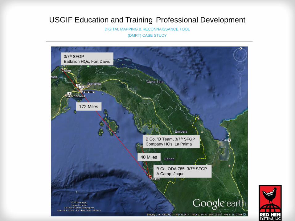
172 Miles
40 Miles
3/7th SFGP
Battalion HQs, Fort Davis
B Co, “B Team, 3/7th SFGP
Company HQs, La Palma
B Co, ODA 785, 3/7th SFGP
A Camp, Jaque
USGIF Education and Training Professional Development DIGITAL MAPPING & RECONNAISSANCE TOOL
(DMRT) CASE STUDY

USGIF Education and Training Professional Development DIGITAL MAPPING & RECONNAISSANCE TOOL
(DMRT) CASE STUDY

B Co “A Camp, ODA 785 3/7th SFGP Battalion HQs, Jaque
USGIF Education and Training Professional Development DIGITAL MAPPING & RECONNAISSANCE TOOL
(DMRT) CASE STUDY
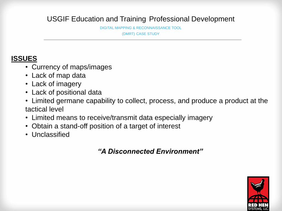
ISSUES
• Currency of maps/images
• Lack of map data
• Lack of imagery
• Lack of positional data
• Limited germane capability to collect, process, and produce a product at the
tactical level
• Limited means to receive/transmit data especially imagery
• Obtain a stand-off position of a target of interest
• Unclassified
“A Disconnected Environment”
USGIF Education and Training Professional Development DIGITAL MAPPING & RECONNAISSANCE TOOL
(DMRT) CASE STUDY

OTHER ISSUES
• No GPS
• No Cellular connectivity
• No Internet
• High regional illiteracy rate
• No roads
USGIF Education and Training Professional Development DIGITAL MAPPING & RECONNAISSANCE TOOL
(DMRT) CASE STUDY

USGIF Education and Training Professional Development DIGITAL MAPPING & RECONNAISSANCE TOOL
(DMRT) CASE STUDY

USGIF Education and Training Professional Development DIGITAL MAPPING & RECONNAISSANCE TOOL
(DMRT) CASE STUDY

USGIF Education and Training Professional Development DIGITAL MAPPING & RECONNAISSANCE TOOL
(DMRT) CASE STUDY
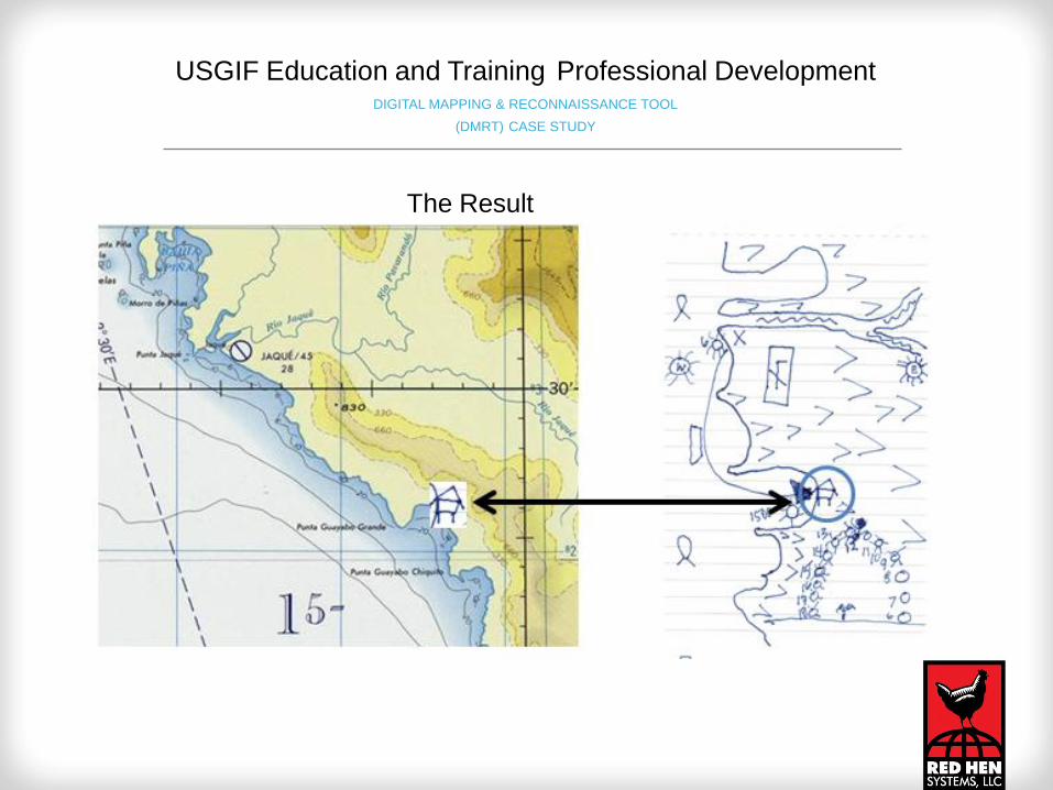
The Result
USGIF Education and Training Professional Development DIGITAL MAPPING & RECONNAISSANCE TOOL
(DMRT) CASE STUDY

ISR imagery collection criteria:
1. Flown at 1900 hrs-The traditional time for individuals having completed dinner and
commencing to sleep as sun set is approximately between 1800-1830 (depending on
the time of the year).
2. Flight path from 140 to 320 degrees (from Punto Guyabo Chico to Punto Guyabo
Grande) and center of the Guyabo Grande bay looking east-Established as a
means to use intersection/resection from various points on the flight path to the hut.
3. 10,000 foot AGL-It was assessed that this altitude would provide the maximum field of
view (FOV) while maintaining acceptable resolution (acceptable resolution being able to
identify an object such as a human). An additional factor that this flight path was
normal for aircraft in the region.
4. Requested IR imagery-If the hut was being occupied IR could pick up a weak light
source such as a cooking fire, and flashlights.
USGIF Education and Training Professional Development DIGITAL MAPPING & RECONNAISSANCE TOOL
(DMRT) CASE STUDY

Phase II-SIMMATs-1992-1996
USGIF Education and Training Professional Development DIGITAL MAPPING & RECONNAISSANCE TOOL
(DMRT) CASE STUDY

The “Special Information Management System (SIMATS)”:
A Mobile Collection system
USGIF Education and Training Professional Development DIGITAL MAPPING & RECONNAISSANCE TOOL
(DMRT) CASE STUDY

Much of SIMATS was based on the
“Feature Maps” technique used in the
Darien which promoted rapid data collection
as illustrated below.
SIMATS also incorporated the
“Time and Space” technique
as well as means for
“situational awareness as
illustrated above.
USGIF Education and Training Professional Development DIGITAL MAPPING & RECONNAISSANCE TOOL
(DMRT) CASE STUDY

The SIMATS concepts were as follows:
• Rapid collection, processing, and product dissemination
• Mobile
• Light weight
• Multi media
• Unclassified
• Low cost
• Off the Shelf Technologies
• Scalable
• Validated information requirements
USGIF Education and Training Professional Development DIGITAL MAPPING & RECONNAISSANCE TOOL
(DMRT) CASE STUDY

Phase III-GPS, The NIMA RRS, and The Digital Mapping System (DMS)-1997-
1999
USGIF Education and Training Professional Development DIGITAL MAPPING & RECONNAISSANCE TOOL
(DMRT) CASE STUDY

Tactics, Techniques, and Procedures:
• Handheld GPS was accessible and low cost
• Internet was accessible and low cost
• The NIMA RRS
• Core Technologies
• GPS
• Digital still/video cameras
• The foundation for DMRT is set
USGIF Education and Training Professional Development DIGITAL MAPPING & RECONNAISSANCE TOOL
(DMRT) CASE STUDY

USGIF Education and Training Professional Development DIGITAL MAPPING & RECONNAISSANCE TOOL
(DMRT) CASE STUDY
USGIF Education and Training Professional Development DIGITAL MAPPING & RECONNAISSANCE TOOL
(DMRT) CASE STUDY
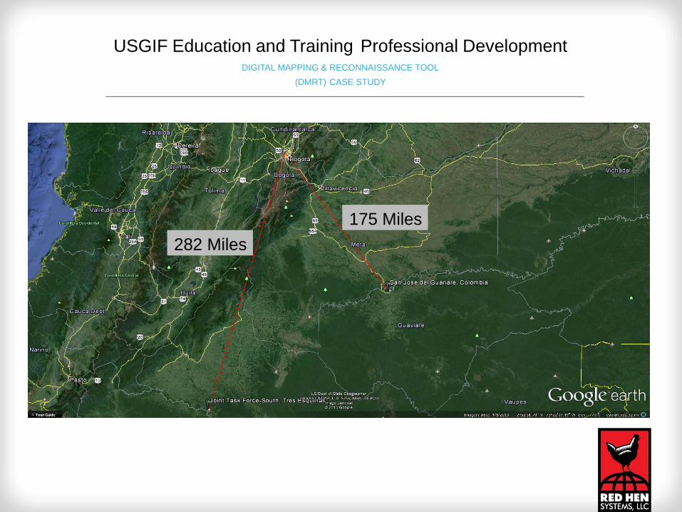
282 Miles
175 Miles
USGIF Education and Training Professional Development DIGITAL MAPPING & RECONNAISSANCE TOOL
(DMRT) CASE STUDY

USGIF Education and Training Professional Development D I G I TA L M A P P I N G & R E C O N N A I S S A N C E T O O L
( D M R T ) C A S E S T U D Y

The Digital Mapping System (DMS)
USGIF Education and Training Professional Development DIGITAL MAPPING & RECONNAISSANCE TOOL
(DMRT) CASE STUDY

Phase IIV-DMRT Becomes Operational and R&D-1999-2005
USGIF Education and Training Professional Development DIGITAL MAPPING & RECONNAISSANCE TOOL
(DMRT) CASE STUDY
USGIF Education and Training Professional Development DIGITAL MAPPING & RECONNAISSANCE TOOL
(DMRT) CASE STUDY

282 miles
USGIF Education and Training Professional Development DIGITAL MAPPING & RECONNAISSANCE TOOL
(DMRT) CASE STUDY

USGIF Education and Training Professional Development DIGITAL MAPPING & RECONNAISSANCE TOOL
(DMRT) CASE STUDY

ISSUES
• Currency of maps/images
• Lack of map data
• Lack of imagery
• Lack of positional data
• Limited germane capability to collect, process,
and produce a product at the tactical level
• Limited means to receive/transmit data
especially imagery
• Obtain a stand-off position of a target of interest
• Unclassified
“A Disconnected Environment”
USGIF Education and Training Professional Development DIGITAL MAPPING & RECONNAISSANCE TOOL
(DMRT) CASE STUDY

OTHER ISSUES
• No Cellular connectivity
• No Internet
• High regional illiteracy
rate
• No roads
USGIF Education and Training Professional Development DIGITAL MAPPING & RECONNAISSANCE TOOL
(DMRT) CASE STUDY

DMRT Core Technologies
Red Hen Systems
Video Mapping Systems
(VMS 200)
iPix Immersive Digital Still
Video Brush Video
Mosaicing Software
USGIF Education and Training Professional Development DIGITAL MAPPING & RECONNAISSANCE TOOL
(DMRT) CASE STUDY
USGIF Education and Training Professional Development DIGITAL MAPPING & RECONNAISSANCE TOOL
(DMRT) CASE STUDY

USGIF Education and Training Professional Development DIGITAL MAPPING & RECONNAISSANCE TOOL
(DMRT) CASE STUDY
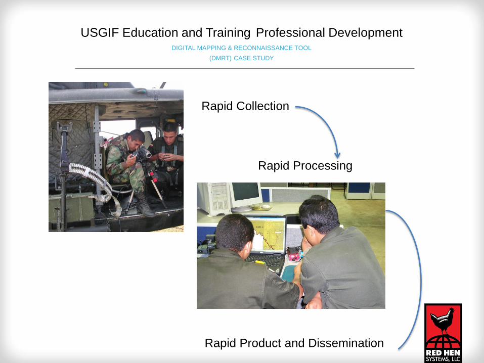
Rapid Collection
Rapid Processing
Rapid Product and Dissemination
USGIF Education and Training Professional Development DIGITAL MAPPING & RECONNAISSANCE TOOL
(DMRT) CASE STUDY

Rapid Product and Dissemination
USGIF Education and Training Professional Development DIGITAL MAPPING & RECONNAISSANCE TOOL
(DMRT) CASE STUDY

Obtaining a Stand-off Position
USGIF Education and Training Professional Development DIGITAL MAPPING & RECONNAISSANCE TOOL
(DMRT) CASE STUDY

Red Hen Systems
Video Mapping Systems
(VMS 200) Processed on MediaMapper
USGIF Education and Training Professional Development DIGITAL MAPPING & RECONNAISSANCE TOOL
(DMRT) CASE STUDY

iPix Immersive Digital Still with Hot Links
USGIF Education and Training Professional Development DIGITAL MAPPING & RECONNAISSANCE TOOL
(DMRT) CASE STUDY

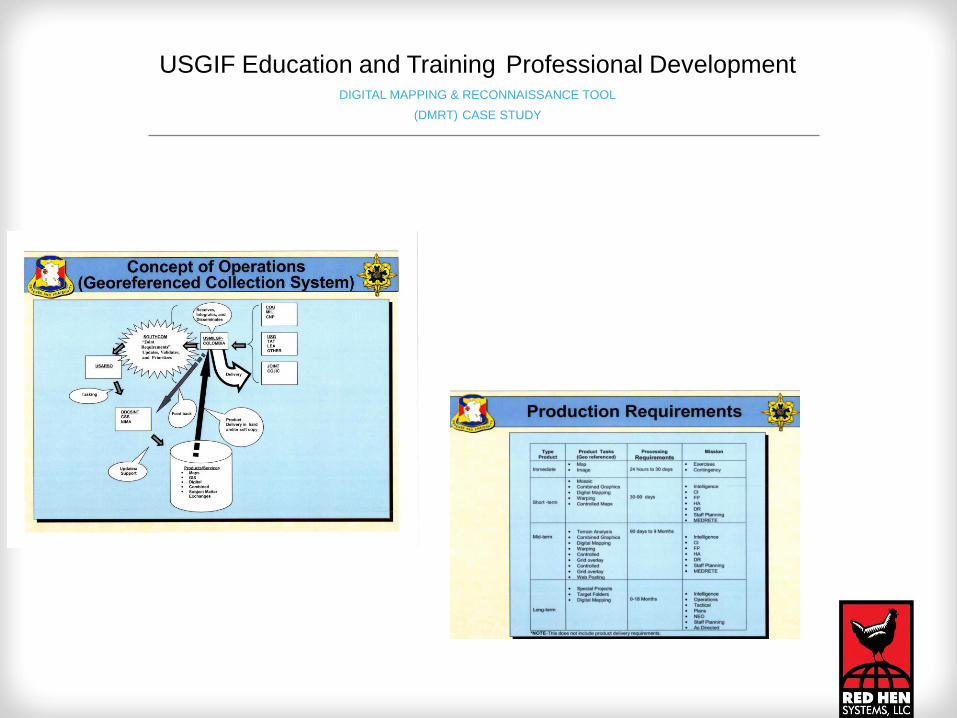
GRIDS: Based on SIMATS and developed for Situational
and
Orientation Awareness with Positional Data
USGIF Education and Training Professional Development DIGITAL MAPPING & RECONNAISSANCE TOOL
(DMRT) CASE STUDY

Video Brush Mosaic of JTF Hot Linked with iPix
USGIF Education and Training Professional Development DIGITAL MAPPING & RECONNAISSANCE TOOL
(DMRT) CASE STUDY

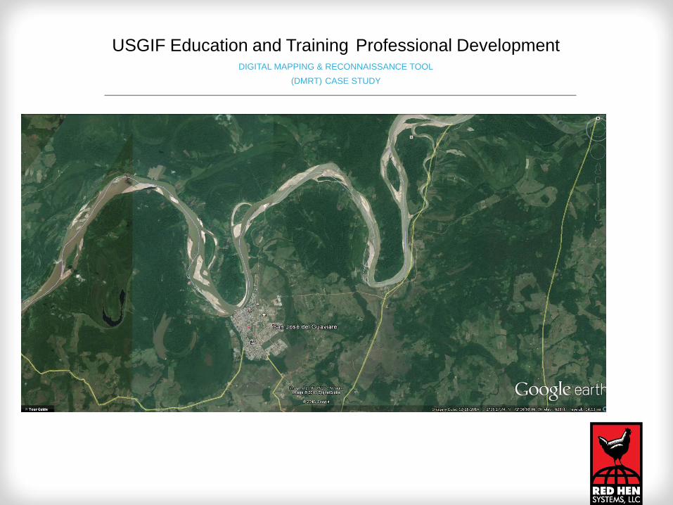
Riverine Mapping Up Date Test
USGIF Education and Training Professional Development DIGITAL MAPPING & RECONNAISSANCE TOOL
(DMRT) CASE STUDY
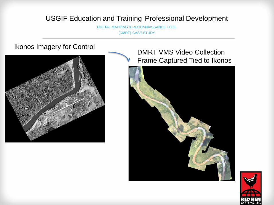
Ikonos Imagery for Control DMRT VMS Video Collection
Frame Captured Tied to Ikonos
USGIF Education and Training Professional Development DIGITAL MAPPING & RECONNAISSANCE TOOL
(DMRT) CASE STUDY

USGIF Education and Training Professional Development DIGITAL MAPPING & RECONNAISSANCE TOOL
(DMRT) CASE STUDY
DMRT Expands

GIMMSS Testing in Puerto Rico
USGIF Education and Training Professional Development DIGITAL MAPPING & RECONNAISSANCE TOOL
(DMRT) CASE STUDY

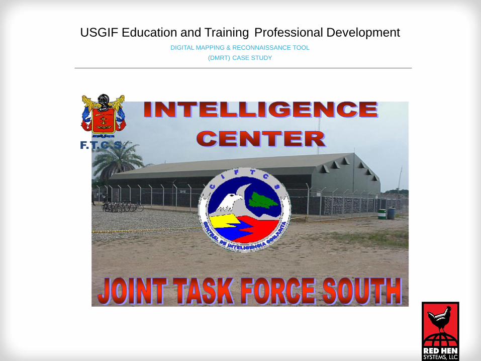
DMRT Used by
The US Capital Police
in National Security Events
USGIF Education and Training Professional Development DIGITAL MAPPING & RECONNAISSANCE TOOL
(DMRT) CASE STUDY

USGIF Education and Training Professional Development DIGITAL MAPPING & RECONNAISSANCE TOOL
(DMRT) CASE STUDY
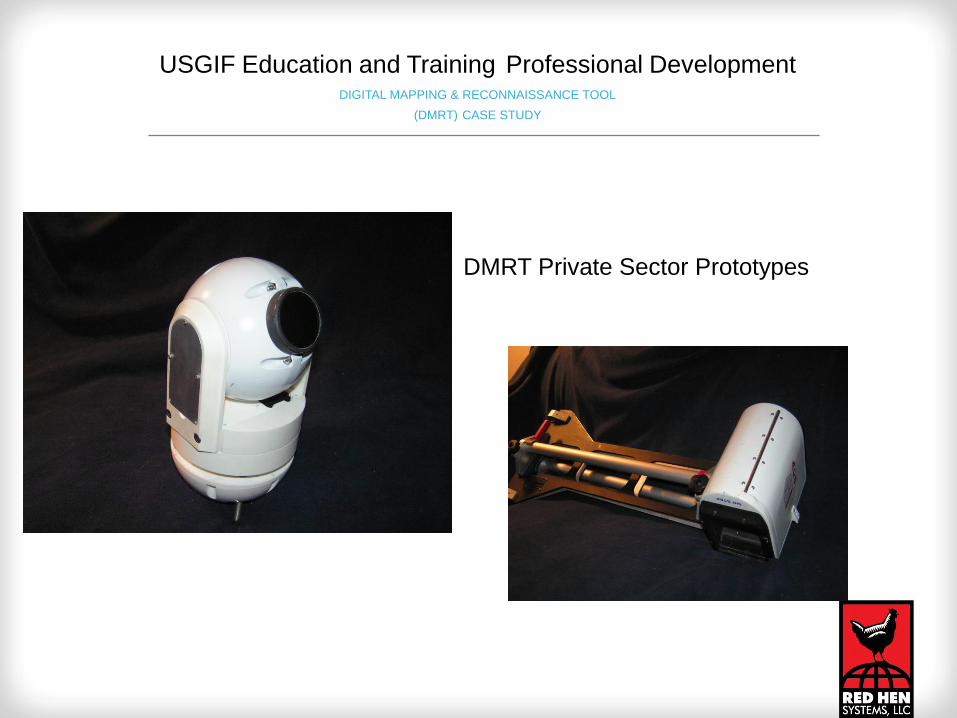
DMRT Private Sector Prototypes
USGIF Education and Training Professional Development DIGITAL MAPPING & RECONNAISSANCE TOOL
(DMRT) CASE STUDY

USGIF Education and Training Professional Development DIGITAL MAPPING & RECONNAISSANCE TOOL
(DMRT) CASE STUDY

Today-The RHS DMRT
USGIF Education and Training Professional Development DIGITAL MAPPING & RECONNAISSANCE TOOL
(DMRT) CASE STUDY

DMRT can now be defined as “A Handheld GEOINT or Mobile GEOINT ISR
capable platform, that's the "First Person View (FPV)", is mobile, and uniquely
capable to obtain aerial, ground, and waterborne stand-off georeferenced
photographs in real-time”.
USGIF Education and Training Professional Development DIGITAL MAPPING & RECONNAISSANCE TOOL
(DMRT) CASE STUDY
Presented by
Bruce A. Donaldson
Mobile GEOINT Manager
970.493.3952
Red Hen Systems
©
Copy Right
USGIF Education and Training Professional Development DIGITAL MAPPING & RECONNAISSANCE TOOL
(DMRT) CASE STUDY