using teledetection in agriculture – method of ... · copyright © (glwxud $fdghplhl 2dphqloru gh...
TRANSCRIPT

Copyright © Editura Academiei Oamenilor de Știință din România, 2009
Watermark Protected
National Scientific Session of the Academy of Romanian Scientists
ISSN 2067 - 2160 Spring – 2009 123
USING TELEDETECTION IN AGRICULTURE – METHOD OF OPTIMIZATION FOR TECHNOLOGIES IN
AGRICULTURAL AND HORTICULTURAL EXPLOITATIONS FOR CURRENT PROPERTY CONDITIONS
Ioan MUNTEANU1, Gabriel M. LEŢ2, Roxana VINTILĂ3
Abstract. România are 238.391 Km2 şi o populaţie de 22,8 mil. locuitori, din care 45% în mediul rural. Agricultura deţine 14,8 mil. hectare (62% din suprafaţa ţării). Numărul de proprietari este de circa 5,5 mil. (multiplicat de peste 2000 ori faţă de pre `89). Ne vom referi doar la aerofotointerpretarea activităţilor din peisajul agricol pe cele două grupuri: cele de nivelment al reliefului (agrar, horticol, agrosilvic) de planimetrie relativ-constante; precum şi a elementelor variabile (structura şi textura solului, condiţii de umiditate) ş.a. Monitorizarea şi cuantificarea se pot structura pe trei niveluri agroecosistemice (cereale pe ton gri, cu habitus lăptos şi granulaţie fină; plante prăşitoare, cu aspect aranjat ordonat şi granulaţie groasă; terenuri recent recoltate unde textura este fină, ton luminos – deschis). CCE (Bruxelless, 05.07.2007) propune „Regulamentul privind acţiunile din perioada 2008-2013 prin intermediul aplicaţiilor de teledetecţie instituite în cadrul politicii agricole comune”, inclusiv în România.
Keywords: ADAM, VALERI, APIA-CCE payments, agricole-ecosystems monitoring, teledetection
1. Introduction Teledetection represent the process of long distance remote signal capture, emitted or remitted by object or processes and their analysis for obtaining information’s about object and their respective processes.
As an EU member state – Romania has 238.391 km2 and an estimated population of 22,8 millions inhabitants, from which 45% in rural areas. Agriculture held’s 14,8 thousand hectares (62% from the country’s surface). After the historical moment of 1989, the country switches to a market economy by radically changing the status of propriety. The number of landowners is about 5.500.000 (multiplied by 2000 times compare to preview period). Dominant are the agricultural exploitation, mixed horticultural, in vast majority practicing agro-technologies of subsistence.
1 Univ. Prof. PhD., Eng., Universitatea de Ştiinţe Agricole si Medicina Veterinara Bucureşti, – full member of the ASAS ([email protected]) 2 PhD. Eng., Staţiunea de Cercetare-Dezvoltare Agricola Brăila - Full Member of Academy of Romanian Scientists, Constanţa branch ([email protected]) 3 Phd. Eng., Institutul Naţional de Cercetare-Dezvoltare pentru Pedologie, Agrochimie şi Protecţia Mediului, Bucureşti – INCPA ([email protected])
Copyright © Editura Academiei Oamenilor de Știință din România, 2009
Watermark Protected
124 Ioan Munteanu, Gabriel M. Leţ, Roxana Vintilă
Between applications of teledetection we will refer in this paper only at aero-photo-interpretation activities from the agricultural area on 2 special groups of elements: those of level relief (agricultural, horticultural, and silviculture) and relatively constant landscaping; as also variable elements (soil structure and texture, humidity conditions) a.o. Monitoring and quantification can be structured on three asro-eco-systemic levels (grey tone grains, with fine granulation and milky habitus; weeder plants, with thick granulation and ordered aspect; recently harvested terrains with fine texture, bright - light tone). The most recent regulations of the EU Commission (Bruxelles, 05.07.2007) proposes "Regulation regarding actions in between 2008-2013 using télédétection applications used in convergence with common agricultural politics", including Romania. In our legislation, adapted by CCE aquis, we have the MAPDR order No. 152 from 26.02.2004 regarding Establishing the reference terms for the organization and functioning of the integrated system for administration and control.
2. Background and approach The first applicative research from Romania (1974-1981), based on using satellites images and the first batch scanning data from technological satellites - LANDSAT type, had the following objectives: the way of land utilization, cultures indexing; crops prognosis and supervising the processes of soil resources degradation (erosion, salinity, flooding, desertification) a.o. The two big geo-morphological entities studied were from Romanian Plain, Brăila and Oltenia Plain (I. Munteanu, Maria Munteanu, C. Grigoras). Based on this operative data there were analyzed the causes for the apparition of an excess of humidity, for the validation of the general drainage of the studied area (N. Florea, 1982-1984). The satellite images were used in numerical (magnetic band strip) as well as photo visualized (black-white and color composite) on the 4,5,7, channels. Field information’s were the thematic charts (pedological, hidrogeological, vegetative, a.o.); aerial photos on panchromatic and infrared films (black-white and colored), culture plans and others.
In the period 1976-1982 SCCASS Brăila solicited collaborations over the vegetative states of crops and over the hidro-ameliorative parameters for each soil type (Ghe. Marin and I. Vişinescu) and on field over the N-E Brăila Plain (G.M.Leţ, 1978-1980).
Working procedures were used in convergence with the batch scanning data format: multispectral bands of 0.5-0.6 p, 0.6-0.7 p, 0.7-0.8 p, 0.8-0.11 p, respectively channels 4,5,6,7, of the stationary satellites.
Copyright © Editura Academiei Oamenilor de Știință din România, 2009
Watermark Protected
Using teledetection in agriculture – method of optimization for technologies
in agricultural and horticultural exploitations for current property conditions 125
The stages of the working method, with numerical data, on magnetic strip, were: - Computer display of echi-densito-metrical charts (1:24000 scale)
on 40 grey levels from channel 6;
- Training sample selection and their statistical conditioning on groups of phenomena;
- Automated classification of data from the studied zone and selected classes display as alphanumerical maps;
The initial working methods were: optico-visual analysis of the satellite data, based on photo-interpretation criteria: tone (color intensity), image structure and texture. There was a Romanian priority of N. Oprescu from the constructions institute of Bucharest.
Resulting from the inter and multi disciplinary (from the countries: France, Argentina, Mexico, Estonia, Belgium) and Romania through collectives whom worked based on a unitary thematic, in the two biggest experiments: ADAM and VALERI.
- ADAM Experiment (http://kalideos.cnes.fr):
The ADAM project was aiming at the development and evaluation of methods capable of exploiting high revisit frequency and high spatial satellite observations. The intensive experimental campaign conducted in 2000-2001 over wheat crops yielded a unique data base where frequent satellite observations at high spatial resolution in the solar and microwave domains were made concurrently to ground characterization of the soil and the canopy and their functioning. This includes 39 SPOT images, 15 Radar (ERS and Radarsat) images, soil permanent characterization, frequent canopy leaf area index, biomass, soil water and nitrogen contents, as measured over 42 sampling units. This intensive campaign was followed in 2002 and 2003 by lighter campaigns where a reduced number of ESUs were sampled, and a reduced number of SPOT scenes acquired.
- VALERI experiment (http://147.100.66.194/valeri):
Validation is mandatory to quantify the reliability of satellite biophysical products that are now routinely generated by a range of sensors. The VALERI project is dedicated to the validation of the products derived from medium resolution satellite sensors (www. avignon.inra.fr/valeri/). It describes the sites used, and the methodology developed to get the high spatial resolution map of the biophysical variables considered, i.e. LAI, fAPAR and JCover that can be estimated from ground level gap fraction measurements.
Sites were selected to represent, with the other validation projects, the large variation of biomes and conditions observed over the Earth's surface.
Copyright © Editura Academiei Oamenilor de Știință din România, 2009
Watermark Protected
126 Ioan Munteanu, Gabriel M. Leţ, Roxana Vintilă
Each site is about 3x3 km2 in size and should be flat and relatively homogeneous at the medium resolution scale. It is mainly based on concurrent use of local ground measurements and a high spatial resolution satellite image, generally SPOT-HRV. Local ground measurements should be representative of an elementary sampling unit (ESU) that has approximately the same size as a SPOT-HRV multispectral pixel. The ground measurements mainly consist of gap fraction measurements achieved with LAI-2000 measurements or hemispherical photographs. The ESUs are selected over the whole 3x3 km2 site in order to sample the vegetation types observed and to allow the derivation of variograms. A transfer function is subsequently established over the ESUs to relate the ground measurements of the biophysical variables with those of the high spatial resolution satellite image. Finally, co-kriging is applied to generate the high spatial resolution map of the biophysical variables over the 3x3 km2 area.
Most recent research in our country was made by collectives from: INCPA Bucharest and INCCPT Fundulea (Roxana Vintila, I.Munteanu 200-2003).
Teledetection based control Addendum for Romania at the Technical Common Specifications (CTS) for teledetection based control (CWRS) for appliance, in 2008, of the Surface Paying Scheme (SAPS), as well as of direct national complementary payments (CNDP), and for under-privileged areas payments (LFA) are only two of the practical applications which are presently run by CTS norm no. 8451/2007 of EU. For each parcel enrolled for assistance in SAPS, the following main verifications are made:
- the reported surface by the agricultural society; - declared surface and type of culture based on the requests of regulations
from payment groups description; - the eligibility of the agricultural parcel at 2008 level as it was defined.
All selected samples are verified if the Good Agricultural and Environmental Conditions (GAEC) are respected. All flagrant infringements, possible to appear from other parcels of the control sample, are to be reported based on CTS.
3. Results and discussion First results drive to actions and organizationally measures essential for the Study of design-development of complex land works in territorial improvements (irrigation-drainage-draining triad), as follows:
1. Soil indexing and terrain quality monitoring (excess of humidity, salting, aeolian deflation);
2. Quality control of the agro-technical and mechanical works (ploughing horizon) for agricultural crops and the topography of meadow and wine yards;
Copyright © Editura Academiei Oamenilor de Știință din România, 2009
Watermark Protected
Using teledetection in agriculture – method of optimization for technologies
in agricultural and horticultural exploitations for current property conditions 127
3. Classification and charting the agricultural landscape (first perimeter was tested at Movila Miresii and Şuţeşti Brăila); also the natural eco-systems components (Crasnicol-Dunavăţ-Rezelu) from the Danube Delta.
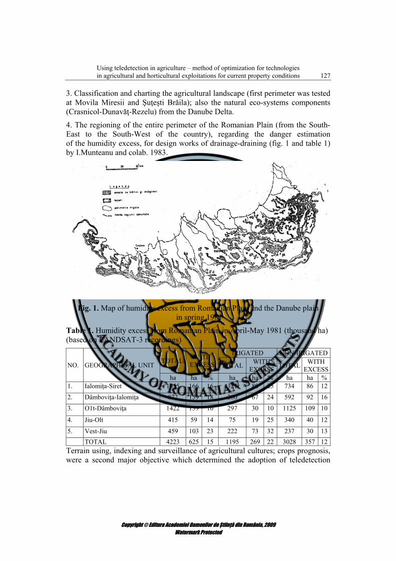
4. The regioning of the entire perimeter of the Romanian Plain (from the South-East to the South-West of the country), regarding the danger estimation of the humidity excess, for design works of drainage-draining (fig. 1 and table 1) by I.Munteanu and colab. 1983.
Fig. 1. Map of humidity excess from Romanian Plain and the Danube plain
in spring 1981
Table 1. Humidity excess from Romanian Plain in April-May 1981 (thousand ha) (based on LANDSAT-3 recordings)
NO. GEOGRAPHICAL UNIT TOTAL WITH EXCESS
IRIGATED NON-IRIGATED
TOTAL WITH EXCESS TOTAL WITH
EXCESSha ha % ha ha % ha ha %
1. Ialomiţa-Siret 1055 166 16 321 80 25 734 86 12
2. Dâmboviţa-Ialomiţa 872 159 18 280 67 24 592 92 16
3. O1t-Dâmboviţa 1422 139 10 297 30 10 1125 109 10
4. Jiu-Olt 415 59 14 75 19 25 340 40 12
5. Vest-Jiu 459 103 23 222 73 32 237 30 13 TOTAL 4223 625 15 1195 269 22 3028 357 12Terrain using, indexing and surveillance of agricultural cultures; crops prognosis, were a second major objective which determined the adoption of teledetection
Copyright © Editura Academiei Oamenilor de Știință din România, 2009
Watermark Protected
128 Ioan Munteanu, Gabriel M. Leţ, Roxana Vintilă
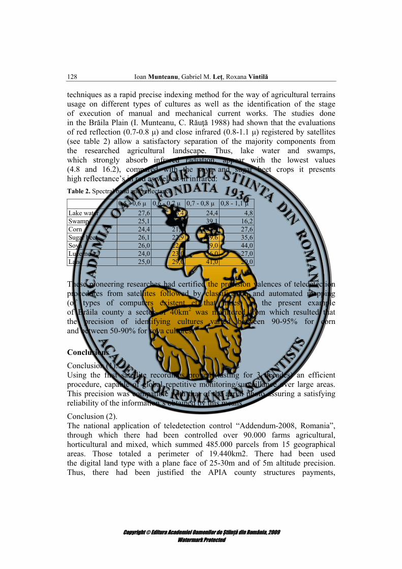
techniques as a rapid precise indexing method for the way of agricultural terrains usage on different types of cultures as well as the identification of the stage of execution of manual and mechanical current works. The studies done in the Brăila Plain (I. Munteanu, C. Răuţă 1988) had shown that the evaluations of red reflection (0.7-0.8 μ) and close infrared (0.8-1.1 μ) registered by satellites (see table 2) allow a satisfactory separation of the majority components from the researched agricultural landscape. Thus, lake water and swamps, which strongly absorb infrared radiation, appear with the lowest values (4.8 and 16.2), compared with the soya and sugar beet crops it presents high reflectance’s in red as well as in infrared: Table 2. Spectral band and reflectance
0,5 - 0,6 μ 0,6 - 0,7 μ 0,7 - 0,8 μ 0,8 - 1,1 μ Lake water 27,6 26.4 24,4 4,8Swamp 25,1 24,2 39,1 16,2Corn 24,4 21,8 53,9 27,6Sugar beet 26,1 22,9 69.6 35,6Soya 26,0 22,0 79,0 44,0Lucerne 24,0 23,0 56,0 27,0Land 25,0 29,0 41,0 20,0
These pioneering researches had certified the precision valences of teledetection procedures from satellites followed by classification and automated mapping (of types of computers existent et that times) in the present example of Brăila county a sector of 40km2 was monitored from which resulted that the precision of identifying cultures varied between 90-95% for corn and between 50-90% for soya cultures.
Conclusions Conclusion (1). Using the first satellite recordings proved (lasting for 3 decades) an efficient procedure, capable of global repetitive monitoring/surveillance over large areas. This precision was compatible with that of the aerial photo assuring a satisfying reliability of the information’s obtained by this means.
Conclusion (2). The national application of teledetection control “Addendum-2008, Romania”, through which there had been controlled over 90.000 farms agricultural, horticultural and mixed, which summed 485.000 parcels from 15 geographical areas. Those totaled a perimeter of 19.440km2. There had been used the digital land type with a plane face of 25-30m and of 5m altitude precision. Thus, there had been justified the APIA county structures payments,
Copyright © Editura Academiei Oamenilor de Știință din România, 2009
Watermark Protected
Using teledetection in agriculture – method of optimization for technologies
in agricultural and horticultural exploitations for current property conditions 129
with Romanian budgeted founds (CNDP) and of EU, through the scheme of unique payments per surface (SAPS).
Conclusion (3). For 2008, around 84% farmers from Brăila County were programmed at the Agricultural Payments and Interventions Agency (APIA). In Brăila agriculture, this majority is of 12893 farmers for a total surface of 47.353,44 ha agricultural lands.
R E F E R E N C E S
[1] A. Canarache, A Soil-Management-Yield system: Case Study in Fundulea – Ileana area.
(Romanian Soil Science Journal, XXXVI (1), p. 20-32, 2002)
[2] Baret F., Vintila Roxana, C. Lazar si colab. The ADAM experiment: a data base to
investigate high temporal revist frecquency at hight spaţial resolution for the monitoring of land
surfaces. (INRA-CSE Asignon, France, 2003)
[3] Bialousz S., Girard M.C. Wapolczynniki odbicia spektralnego gleb w pasmach pracy
satelity LANDSAT (Fotointerpr. w geografii T. III(13), Katowice-Polska, 1978)
[4] F. Baret, R. Vintila, C. Lazar, N. Rochdi, L. Prévôt, J.C. Favard, H. de FJoissezon, C.
Lauvernet, E. Petcu, G. Petcu, P. Voicu, J. P. Denux, V. Poenaru, C Simota, O. Marloie, F. Cabot,
P. Henry The ADAM experiment: a data base to investigate high temporal revisit frequency at
high spatial resolution for the monitoring of land surfaces (2003)
[5] Frederic Baret, Marie Weiss, Denis Allard, Sebastien Garrigue, Marc Leroy, Herve
Jeanjean, R.Fernandes, R.Myneni, J.Privette, J.Morisette, Herve Bahbot, Roland Bosseno, Gerard
Dedieu, Carlos Di Bella, Benoit Duchemin, Marisa Espana, Valery Gond, Xing Fa Gu, Dominique
Guyon, Camille Lelong, Philippe Maisongrande, Eric Mougin, Tiit Nilson, Frank Veroustraete,
Roxana Vintila VALERI: a network of sites and a methodology for the validation of medium
spatial resolution satellite products (2003)
[6] Let G., Un deceniu de la primele aplicaţii in agricultura judeţului Brăila folosind
teledetectia prin sateliţi. (Buletin informativ, AOS-R filiala Brăila, p. 3-4, 1986)
[7] Marin Gh., Cercetări privind evoluţia regimului apelor freatice si solurilor in cursul
exploatării amenajărilor de irigaţii din sistemul Terasa Brailei-nord (Cazasu). (Teză de doctorat,
IANB, Bucureşti, 1981)
[8] Munteanu I., Munteanu Maria, Grigoras C., Marin Ghe. Utilizarea inregistrarilor de pe
sateliti pentru inventarierea excesului de umiditate din Campia Romana si Lunca Dunarii –
Copyright © Editura Academiei Oamenilor de Știință din România, 2009
Watermark Protected
130 Ioan Munteanu, Gabriel M. Leţ, Roxana Vintilă
Lucrarile Conferintei Nationale pentru Stinta Solului “geneza, clasificarea si cartografia solurilor”
(Braila 30-07, 02-09 1982 Societatea Nationala Romana pentru Stiinta Solului nr.210/1983)
[9] Munteanu I., Răuţă C. Teledetectia in agricultura, present si perspective (Revista Stiinţă şi
Tehnică, nr.12, 1988)
[10] Ordinul MADR nr. 15/56/2008 pentru adoptarea măsurilor privind bunele condiţii agricole
şi de mediu în România
[11] Ordinul MADR nr. 246/2008 privind stabilirea modului de implementare, a condiţiilor
specifice şi a criteriilor de eligibilitate, pentru aplicarea schemelor de plăţi directe şi plăţi naţionale
directe complementare, în sectorul vegetal, pentru acordarea sprijinului aferent măsurilor de
agromediu şi zone defavorizate
[12] Ordinul MADR nr.91/2008 privind modalitatea de acordare a plăţilor tranzitorii pentru
tomate destinate procesării şi aprobarea prim-procesatorilor
[13] Ordinul MADR nr. 139/2008 privind modificarea anexei la Ordinul ministrului agriculturii
şi dezvoltării rurale nr. 64/B/2008 privind aprobarea formularului de cerere de plată pentru
schemele de sprijin pe suprafaţă pentru anul 2008
[14] Ordinul MADR nr. 64/B/2008 privind aprobarea formularului de cerere de plată pentru
schemele de sprijin pe suprafaţă pentru anul 2008
[15] Ordinul MADR nr. 909/2007 pentru modificarea Ordinului MADR 549/2007 privind
stabilirea modului de implementare, a condiţiilor specifice şi a criteriilor de eligibilitate, pentru
aplicarea schemei de plăţi directe pe suprafaţă pentru culturi energetice
[16] Ordinul MADR nr. 549/2007 privind stabilirea modului de implementare, a condiţiilor
specifice şi a criteriilor de eligibilitate, pentru aplicarea schemei de plăţi directe pe suprafaţă
pentru culturi energetice
[17] Ordinul MADR nr. 355/2007 privind criteriile de încadrare, delimitarea şi lista unităţilor
administrativ-teritoriale din zona montană defavorizată din România