usrap coding manual for star ratings and safer …rsouley/ce 635-2017/docs/usrap coding... · usrap...
TRANSCRIPT

usRAP Coding Manual for Star Ratings and
Safer Roads Investment Plans ViDA Version 3.0
July 2016
NOT FOR RELEASE—except to highway agencies conducting usRAP
studies and accredited providers of usRAP services

usRAP Coding Manual for Star Ratings and Safer Roads Investment Plans | 1
About usRAP The U.S. Road Assessment Program (usRAP) was initiated by the AAA Foundation for Traffic Safety and is
now sponsored by the Roadway Safety Foundation, in cooperation with the Federal Highway Administration.
usRAP works in partnership with government and non-government organizations to:
• encourage highway agencies to make safety decisions in management of road networks based on
rational assessment of risk
• inspect roads and develop Star Ratings and Safer Roads Investment Plans
• provide training, technology, and support that will build and sustain national, state, and local
capabilities
• track road safety performance so that funding agencies can assess the benefits of their investments.
usRAP works in close partnership with the International Road Assessment Programme (iRAP), a registered
charity based in the United Kingdom, which coordinates RAP activities throughout the world. Road
Assessment Programs (RAPs) are now active in more than 70 countries throughout Europe; Asia Pacific;
North, Central, and South America; and Africa.
For more information
For more information on usRAP coding for Star Ratings and Safer Roads Investment Plans, contact:
Douglas W. Harwood
MRIGlobal
(816) 360-5336
Zachary N. Hans
Iowa State University
(515) 294-2329
To find out more about usRAP, visit www.usrap.org
©Roadway Safety Foundation 2016
usRAP technology including protocols, processes, brands, and software may not be altered or used in any way without
the express written agreement of the Roadway Safety Foundation.

usRAP Coding Manual for Star Ratings and Safer Roads Investment Plans | 2

usRAP Coding Manual for Star Ratings and Safer Roads Investment Plans | 3
Version Date Version Update 11/30/12 November 2012 Base version of document (adapted from iRAP materials) 6/24/13 June 2013 Updated based on recent experience 1/30/15 January 2015 Updated for compatibility with ViDA Version 3.0 7/10/16 July 2016 Updated based on recent experience
Contents 1 ......................................................................................................................................................... Introduction
........................................................................................................................................................................... 7
1.1 ViDA Software ...................................................................................................................................... 7
1.2 Units of Measure ................................................................................................................................... 8
2 ViDA Data Coding and Analysis Process ................................................................................................... 9
2.1 Stage 1 – Data Acquisition and Data Coding ....................................................................................... 9
2.2 Stage 2 – Pre-Processing of Data Prior to Analysis ............................................................................. 9
2.3 Stage 3 – Analysis With ViDA Software ............................................................................................. 10
3 Undivided vs. Divided Roadways ............................................................................................................. 11
4 Quality Control .......................................................................................................................................... 13
5 Coding Definitions for Specific Roadway Attributes ................................................................................. 15
5.1 Coder Name ....................................................................................................................................... 15
5.2 Coding Date ........................................................................................................................................ 15
5.3 Road Survey Date .............................................................................................................................. 15
5.4 Image Reference ................................................................................................................................ 15
5.5 Road Name ......................................................................................................................................... 15
5.6 Section Name/Number ....................................................................................................................... 16
5.7 Distance .............................................................................................................................................. 16
5.8 Length ................................................................................................................................................. 17
5.9 Latitude and Longitude ....................................................................................................................... 17
5.10 Landmark ....................................................................................................................................... 17
5.11 Comments ...................................................................................................................................... 18
5.12 Carriageway/Roadway Type .......................................................................................................... 19

usRAP Coding Manual for Star Ratings and Safer Roads Investment Plans | 4
5.13 Upgrade Cost ................................................................................................................................. 20
5.14 Observed Motorcycle Flow ............................................................................................................. 22
5.15 Observed Bicycle Flow ................................................................................................................... 22
5.16 Observed Pedestrian Flow—Crossing Road ................................................................................. 23
5.17 Observed Pedestrian Flow—Along Road—Left Side .................................................................... 24
5.18 Pedestrian Flow—Along Road—Right Side ................................................................................... 25
5.19 Land Use—Left Side and Land Use—Right Side .......................................................................... 26
5.20 Area Type ....................................................................................................................................... 29
5.21 Speed Limit .................................................................................................................................... 30
5.22 Motorcycle Speed Limit .................................................................................................................. 30
5.23 Truck Speed Limit .......................................................................................................................... 30
5.24 Median Type ................................................................................................................................... 31
5.25 Centerline Rumble Strip ................................................................................................................. 36
5.26 Roadside Severity Distance—Right Side ....................................................................................... 37
5.27 Roadside Severity Object—Right Side .......................................................................................... 39
5.28 Roadside Severity Distance—Left Side ......................................................................................... 45
5.29 Roadside Severity Object—Left Side ............................................................................................. 45
5.30 Shoulder Rumble Strips ................................................................................................................. 46
5.31 Paved Shoulder Width—Left Side and Paved Shoulder Width—Right Side ................................. 47
5.32 Intersection Type ............................................................................................................................ 49
5.33 Intersection Channelization ............................................................................................................ 55
5.34 Intersecting Road Volume .............................................................................................................. 56
5.35 Intersection Quality ......................................................................................................................... 59
5.36 Property Access Points .................................................................................................................. 61
5.37 Number of Lanes for Use by Though Traffic .................................................................................. 63
5.38 Lane Width for Lanes Serving Through Traffic .............................................................................. 66
5.39 Curvature ........................................................................................................................................ 68
5.40 Quality of Curve .............................................................................................................................. 69
5.41 Grade.............................................................................................................................................. 71
5.42 Road Condition ............................................................................................................................... 72

usRAP Coding Manual for Star Ratings and Safer Roads Investment Plans | 5
5.43 Road Surface Type/Skid Resistance ............................................................................................. 74
5.44 Delineation ..................................................................................................................................... 77
5.45 Street Lighting ................................................................................................................................ 79
5.46 Pedestrian Crossing Facilities—Inspected Road ........................................................................... 80
5.47 Quality of Crossing ......................................................................................................................... 83
5.48 Pedestrian Crossing Facilities—Side Road ................................................................................... 84
5.49 Pedestrian Fencing ........................................................................................................................ 85
5.50 Speed Management/Traffic Calming .............................................................................................. 86
5.51 Vehicle Parking .............................................................................................................................. 87
5.52 Sidewalk—Left Side ....................................................................................................................... 88
5.53 Sidewalk—Right Side ..................................................................................................................... 91
5.54 Service Road .................................................................................................................................. 94
5.55 Motorcycle Facilities ....................................................................................................................... 95
5.56 Bicycle Facilities ............................................................................................................................. 98
5.57 Roadworks (Work Zones)............................................................................................................. 101
5.58 Sight Distance .............................................................................................................................. 103
5.59 School Zone Warning ................................................................................................................... 104
5.60 School Zone Crossing Guard ....................................................................................................... 104
6 Pre-Processing usRAP Input Data After Coding .................................................................................... 105
Appendix A – Specification for Coded Data File ........................................................................................... 107
Appendix B - Input Data File Specification for Uploading to ViDA Software ................................................. 119
Appendix C - Coding Examples ..................................................................................................................... 137

usRAP Coding Manual for Star Ratings and Safer Roads Investment Plans | 6

usRAP Coding Manual for Star Ratings and Safer Roads Investment Plans | 7
1 Introduction The purpose of the usRAP Star Ratings is to assess the level of risk of fatal or serious injuries to road users contributed by the road infrastructure. The usRAP Star Rating protocol has been developed to assess the level of risk relevant to vehicle occupants, pedestrians, bicyclists and motorcyclists on both rural and urban roads. This risk assessment is performed with data coded in accordance with the definitions and procedures in this manual.
The Safer Roads Investment Plan protocol and the ViDA software are not dependent on the availability of detailed site-specific crash data, although network-wide crash data are useful for model calibration. ViDA provides a unique analysis capability since nearly all other safety planning and Safety management tools require detailed, site-specific crash data as input. While ViDA is ideally suited for application by highway agencies without access to detailed, site-specific crash data it can be also applied by highway agencies with good crash data because it provides an efficient method to identify safety improvement locations and appropriate countermeasures.
ViDA software generates relative risk scores known as the Road Safety Scores (RSS) for each road user group, uses the RSS and inspection data to estimate the expected number of fatalities and serious injuries on a road segment, generates countermeasures and determines the best value network safety upgrading programs through economic appraisal. All usRAP calculations and data-processing is carried out by the ViDA software to ensure good access to the data and consistency across the program. Version 3.0 of the ViDA software is now in use, and this Manual addresses coding for ViDA Version 3.0.
1.1 ViDA Software
ViDA software serves as a network-level safety planning tool to identify highway infrastructure improvement locations and countermeasure types. ViDA considers the need for a cost-effectiveness of over 70 candidate countermeasures. ViDA output provides recommended locations for network-wide application of each of these countermeasures. The ViDA output should be considered as a preliminary recommended safety improvement program. Highway agencies should undertake detailed engineering studies of each potential improvement location to confirm or modify the countermeasure recommendation and to develop preliminary and final engineering designs for each project. These detailed engineering studies and the development of engineering designs can be undertaken through traditional methods or with the assistance of tools such as the Interactive Highway Safety Design Model (IHSDM) and Safety Analyst.
Key elements in the application of ViDA include:
a) Road Safety Score
Road features are scored and combined to reflect the overall safety of the infrastructure on a road section – both the likelihood of being involved in an accident and the potential injury severity are taken into account.
A Road Safety score for each road user group is generated for individual road segments and sections and can be shown on a map.
b) Generating Countermeasures
A logical system, based on engineering-based countermeasure triggers, is used to generate programs of low-cost countermeasures that are likely to save a substantial number of lives. Over 70 potential crash countermeasures are reviewed for each 300-ft (100-m) road segment on the network and those countermeasures that make engineering sense are carried forward into more detailed safety and economic analyses.

usRAP Coding Manual for Star Ratings and Safer Roads Investment Plans | 8
c) Estimating Fatality and Serious Injury Frequencies
iRAP and usRAP have established a methodology to estimate the number of fatalities and serious injuries that would be expected on a road section based on the physical characteristics of the roadway and the traffic control devices present. The methodology can be applied to estimate fatality and serious frequencies for the existing roadway and for the improved roadway with specific countermeasures in place. The results are used alongside the countermeasure generation tool to estimate the number of casualties that are likely to be saved through action.
d) Economic Appraisal
In order to make the best investment decisions, usRAP’s economic appraisal methodology compares the cost of implementing specific countermeasures with the economic benefits of saving lives and reducing serious injuries. A default methodology for estimating the cost of deaths and serious injuries is used, but fatality and serious injury cost estimates preferred by specific highway agencies may be used in place of the default estimates.
e) Detailed Engineering Studies
The results from the ViDA software suggest implementation of specific countermeasures at specific locations. Given the planning-level nature of this software tool, these suggestions require detailed engineering studies by competent engineering professionals with local knowledge before any final decisions on countermeasure implementation are made. Detailed engineering studies typically consider site-specific conditions and countermeasure costs in greater detail than is possible in a usRAP evaluation and it is likely that countermeasure recommendations may be changed as a result of the detailed engineering studies. The strength of the usRAP planning-level evaluation is that it quickly directs attention to specific locations where specific countermeasure types may be cost-effective.
f) iRAP Road Safety Toolkit
The iRAP road safety toolkit is available on the internet for road safety practitioners. The focus of the toolkit is to provide a comprehensive and easy to use road safety resource to help practitioners fully understand the crash countermeasure available to reduce fatalities and serious injuries. Additional U.S.-specific information is available in the AASHTO Highway Safety Manual, in the NCHRP Report 500 series, in other published reports, and in the FHWA Crash Modification Factors (CMF) clearinghouse.
1.2 Units of Measure
This manual is presented almost entirely in U.S. customary units. At present, metric equivalents to many of the values appear in the ViDA software. This will be corrected in a later version of the software.
All data are coded for 100-m road segments. This distance in metric units is used in the current software, since the software was developed for worldwide application. The equivalent of 100 m in U.S. customary units is 327 ft. For convenience in this manual, we will refer to 300-ft (100-m) road segments. Keep in mind, however, that when setting up data acquisition systems (e.g., from video review), the road sections should be exactly 100 m or 327 ft in length.

usRAP Coding Manual for Star Ratings and Safer Roads Investment Plans | 9
2 ViDA Data Coding and Analysis Process The usRAP process can be broken down into three major stages, as shown in Figure 1.
Figure 1: ViDA Data Coding and Analysis Process
2.1 Stage 1 – Data Acquisition and Data Coding
This stage incorporates selecting the road network to be studied, acquiring video images of the roadway, and data coding. This process is referred to by usRAP as road inspection. The data coding procedures are the subject of Section 5 of this manual.
The road network to be studied should generally include the roads under the jurisdiction of a specific agency on which the most fatal and serious injury crashes are expected to occur. Typically, at least the highest volume 10 percent of an agency’s network should be included. Alternatively, specialized studies may focus on either larger or smaller networks—an agency’s entire road network or on particular road sections that are candidates for improvement.
In larger studies, the road survey network should generally be carried out so that the roads where the highest proportion of the crashes occurs are inspected first. Typically, these are the highest volume roads.
The road survey is typically carried out by collecting imaging and georeferencing data using an inspection vehicle; these images are then used for data coding back in the office. Alternatively, existing videos such as highway agency videologs or Google Street View images may be used.
The roadway characteristics data needed for a usRAP study should be coded in accordance with the procedures presented in Section 5 of this manual. Appendix A summarizes all of the codes used in the data coding process and presents a suggested format for data coding.
The usRAP Team Leader should carry out quality assurance checks while the coding is under way to assure that each coder understands their task and is providing accurate data.
If some of the data elements to be coded are available from existing highway agency files or databases, the existing data should be used, once their accuracy has been verified, rather than making the unnecessary effort of recoding the data.
2.2 Stage 2 – Pre-Processing of Data Prior to Analysis
The pre-processing of data is generally carried out after the coding of the data is complete, but before the data analysis begins. In this stage the data is converted from the format provided by the data coding system into the format required for uploading to the ViDA software. In addition to this the pre-processing stage can be used to combine different data items to create some final attributes required for the software. The discussion in Section 5 of this manual indicates that certain attributes may often be coded in preliminary form and then placed in final form in the pre-processing stage.
In addition, several additional variables are added from highway agency data or derived from coded data in the pre-processing stage (see Section 6). The pre-processing stage is also used to review the coded data to check for internal consistency and accuracy, prior to analysis of the data.
Data Acquisition and Data Coding
Pre-Processing of Data Prior to Analysis
Analysis with ViDA Software

usRAP Coding Manual for Star Ratings and Safer Roads Investment Plans | 10
Appendix B presents the required format for the upload file that serves as input to the ViDA software.
Detailed procedures for the pre-processing stage are presented in the Guide to Producing usRAP Star Ratings and Safer Roads Investment Plans.
2.3 Stage 3 – Analysis With ViDA Software
This stage involves preparing the software to accept data for a road network, uploading the coded data, calibrating the road network, analysing the data, and interpreting the analysis results. This stage is described in more detail in the Guide for Producing usRAP Star Ratings and Safer Roads Investment Plans and the Guide for Using usRAP Star Ratings and Safer Roads Investment Plans.

usRAP Coding Manual for Star Ratings and Safer Roads Investment Plans | 11
3 Undivided vs. Divided Roadways In coding data for ViDA software, divided and undivided carriageways (or divided and undivided carriageways as they are called internationally) are coded differently. This is because divided roadways generally coded are in both directions or travel, but undivided roadways are coded in only one direction of travel. Divided roadways are those with a physical separation of the opposing traffic flows – separated either by a barrier or a physical median (i.e., a median other than a flush separation). In the following discussion, left and right are determined with respect to the roadway direction being coded.
On an undivided roadway (see Figure 2):
• The Median is the road feature that separates the opposing vehicle flows. Medians for undivided roadways are coded to indicate that there is no barrier and no physical median.
• The crash risk for the Roadside Left is characterized by the distance to nearest aggressive object to the left of the roadway being rated, measured from the left edge of the traveled way to the object.
• The crash risk for Roadside Right is characterized by the distance to nearest aggressive object to the right of the roadway being rated, measured from the right edge of the traveled way to the object.
• Left and right are determined with respect to the primary direction of travel, which may be the direction in which the video was recorded or the direction of increasing highway agency mileposts.
Figure 2: Undivided roadway coding
On a divided roadway (see Figure 3):
• The Median is the feature that separates that opposing vehicle flows; therefore, the width of a median from the left edge of one traveled way to the left edge of the other traveled way, irrespective of whether there are aggressive objects in the median.
• The crash risk for the Roadside Left is characterized by the distance to nearest aggressive object to the left of the roadway being rated measured from the left edge of the traveled way to the object. The nearest aggressive object may be in the median or may be on the far side of the opposing roadway.
• The crash risk for Roadside Right is used to record the nearest aggressive object to the right of the roadway being rated, measured from the right edge of the traveled way to the object.
• Left and right for each roadway are determined with respect to vehicles traveling on a particular roadway of the divided highway. Thus, left is always toward the median and right is always toward the outside of the roadway whose attributes are being coded.
Roadside Left Roadside Right Median

usRAP Coding Manual for Star Ratings and Safer Roads Investment Plans | 12
Figure 3: Divided roadway coding for the roadway shown to the right
For more examples, please see Appendix C.
Roadside Left Roadside Right Median

usRAP Coding Manual for Star Ratings and Safer Roads Investment Plans | 13
4 Quality Control To help attain a high level of accuracy in the data collected and coded the following procedures should be followed:
• Coders for usRAP data should be trained by an accredited training organization and an accredited instructor.
• The name of the coder who coded the attributes for each location should be recorded. This information is included to help trace and correct any inconsistencies in the data.
• One coder should be responsible for an extended length of road, such as for an entire route. This helps insure consistency over the length of that route.
• Data files should be backed up on a regular basis throughout the roadway attribute coding process.
• Following completion of the roadway attribute coding process for each length of road, the data should be reviewed for accuracy by a separate coder (or by the usRAP Team Leader) and any errors or inconsistencies should then be noted and corrected. Errors should be reviewed by the coding team to help build consistency in the coding.
• A sample of the data should be reviewed for accuracy by usRAP, or by an accredited usRAP Team Leader to encourage consistency across the program. This review may be conducted as part of the post-processing stage.

usRAP Coding Manual for Star Ratings and Safer Roads Investment Plans | 14

usRAP Coding Manual for Star Ratings and Safer Roads Investment Plans | 15
5 Coding Definitions for Specific Roadway Attributes
All of the roadway attributes covered within this section of the manual (with the exception of image reference, described in Section 5.4) are mandatory for usRAP ViDA Version 3.0 calculations.
The coding categories for each attribute are presented in Section 5 in order of descending risk, from highest to lowest risk. Where two or more potentially applicable coding categories are present within a 300-ft (100-m) section, the highest applicable risk category (i.e., the category described first) should be coded. All of the codes are summarized in Appendix A of this manual. Procedures for data processing are presented in the Guide for Producing usRAP Star Ratings and Safer Road Investment Plans.
5.1 Coder Name
The name of the coding team member who coded the data should be recorded for each 300-ft (100-m) segment. This will assist in the quality assurance process and enable the data to be traced. The coder name is a text field into which any alphanumeric data specified by the user can be entered. This field should not contain any punctuation marks such as commas, semi-colons, slashes, or apostrophes. Parentheses, hyphens, and periods are permitted.
5.2 Coding Date
The date the coding was carried out on should be recorded in the format dd/mm/yyyy.
5.3 Road Survey Date
The date on which the road survey was carried out or the roadway video was recorded in the format dd/mm/yyyy. If no road survey was conducted in the field as part of the usRAP study, the road survey date should be the same as the coding date. In this case, the road survey date may be left blank during the coding process and filled in during the pre-processing stage.
5.4 Image Reference
An Image Reference for the each 300-ft (100-m) segment length should be recorded, where applicable. For example this may take the form of a survey reference/file name in combination with at frame number or a video file name in combination with a time stamp. The image reference is not relevant if a video source without frame numbers is used. Where not relevant, the image reference may be left blank.
5.5 Road Name
The road name, street name, or route number should be included within the input file for each 300-ft (100-m) segment to identify which road the data refers to.
usRAP Coding Manual for Star Ratings and Safer Roads Investment Plans | 16
The Road Name attribute is a text field into which any alphanumeric data specified by the user can be entered. This field should not contain any punctuation marks such as commas, semi-colons, slashes, or apostrophes. Parentheses, hyphens, and periods are permitted.
5.6 Section Name/Number
Each road identified by its road name or route number may be treated as a single road section or may be subdivided into two or more road sections. Each of these road sections should be identified by a unique section name or number. These section names or numbers may be assigned by the usRAP Team Leader or the usRAP Team Leader may choose to adopt a section naming or numbering convention used by the highway agency (e.g., for management, maintenance, or control sections). At the option of the usRAP Team Leader, the section number may be entered by the coders or added to the data file in post-processing.
Each road section consists of multiple 300-ft (100-m) road segments. There is no minimum or maximum length for road segments, but the ViDA software will probably be most useful if sections are no more than 1 to 5 mi in length in urban and suburban areas and no more that 15 or 20 mi in length in rural areas. Software issues were noted in an earlier version of the software when a road section included more than 1,000 segments, so sections should not exceed 62 mi in length.
The Section Name/Number field is a text field into which any alphanumeric data specified by the user can be entered. This field should not contain any punctuation marks such as commas, semi-colons, slashes, or apostrophes. Parentheses, hyphens, and periods are permitted.
ViDA sorts Section Names/Numbers as text data rather than as numerical data. Past projects have encountered problems in transferring leading zeros in section numbers from Excel into ViDA using comma separated value (csv) files. Therefore, if you want to use section numbers with leading zeros (i.e., 001, 002, 003, …) it is suggested that you start the Section Name/Number with a letter (i.e., S001, S002, S003,…).
Please note that the ViDA software uses the international term double carriageway for divided highways and single carriageway for undivided highways. In most cases, divided highways should be coded as separate road sections for each direction of travel. However, short sections of divided highway with medians may be included in a undivided highway section with a median with little loss of fidelity in the analysis results. This approach is useful on roads that have frequent transitions from undivided to divided cross sections. Sections on a divided highway that are opposite one another may be conveniently identified using the same section number with a letter added to distinguish the direction of travel. For example, an eastbound roadway section of a divided highway might be designated as Section 201A, while the corresponding westbound section of roadway might be designated Section 201B.
5.7 Distance
The Distance attribute will normally contain the distance in kilometers from the start of the road or road section. The distance is used in the analysis stage to arrange the data along a road in geographical order. In some projects, it may be desirable to use as the Distance attribute, the equivalent of the milepost assigned to each road segment by the highway agency. This is not too meaningful in the current ViDA software since the distance must be in kilometres. However, it is possible to use the milepost equivalent in kilometres as the Distance attribute and include the milepost in miles for reference in the Comments field. The distance attribute is one of two measured attributes in the current software that must be entered in kilometres (see also Section 5.8).

usRAP Coding Manual for Star Ratings and Safer Roads Investment Plans | 17
5.8 Length
The segment Length field will contain the length in kilometres for the road segment that the coding applies to. Since all road segments should be 300-ft (100-m) in length, the entry in this field should always be 0.1 km. Some segments at the end of a road section may have an uneven length less than 0.1 km, but 0.1 km should still be entered in the length field for every roadway segment. The segment length is used in the analysis stage to help with smoothing of Star Rating data. The length attribute is one of two measured attributes in the current software that must be entered in kilometres (see also Section 5.7). The Length attribute may either be entered as 0.1 during the coding stage or added in the preprocessing stage.
5.9 Latitude and Longitude
The Latitude and Longitude attributes should contain the respective GPS coordinates in decimal degrees and WGS84 projection for the start point for each 300-ft (100-m) road segment. At least five or six decimal places in latitude and longitude values are desirable. Latitude values in the United States are always positive (e.g., 43.246817), indicating North latitude. Longitude values in the United States are always negative (e.g., –83.769251), indicating West longitude.
5.10 Landmark
For the purpose of usRAP reporting it is beneficial to code the names of key landmarks where they occur. This will allow locations on the road to be referenced relative to the landmarks.
Landmarks can be any of the following or other items of interest:
• Town or village name (at location of sign or corporate limits)
• At intersections, intersecting road name or route number
• Major bridge
• Interchange ramp
• Toll booth
• Reference point
Landmarks can either be entered during the coding of the attribute data or can be added from maps at a later stage.
The Landmark field is a text field. Any alphanumeric text may be used. This field should not contain punctuation marks such as commas, semi-colons, slashes, or apostrophes. Parentheses, hyphens, and periods are permitted. There is no formal upper limit on the number of characters in a landmark entry, but entries over 60 characters in length may become awkward in data management.
usRAP Coding Manual for Star Ratings and Safer Roads Investment Plans | 18
5.11 Comments
For the purpose of usRAP reporting it is important to record key comments to highlight particular road safety issues or special features encountered during the coding process. Comments may include issues not fully covered by the coding itself or additional location information. Codes should not enter Comments unless they are potentially relevant to engineering issues.
Include any supporting information or notes on assumptions made during the coding of the section for example:
• Pedestrian fencing present
• High proportion of trucks
• Near school so pedestrian demand assumed as high
• Poles assumed to be frangible
The Comments field is a text field into which any alphanumeric data may be entered. This field should not contain any punctuation marks such as commas, semi-colons, slashes, or apostrophes. Parenthesis, hyphens, and periods are permitted.
The usRAP Team Leader may assign specific uses for the comment field. For example, in one recent project, the milepost value in miles was placed in the comment field (i.e., MP 2.24), since only the equivalent in kilometres could be included in the Distance field (see Section 5.7).

usRAP Coding Manual for Star Ratings and Safer Roads Investment Plans | 19
5.12 Carriageway/Roadway Type
Each section of road requires a Carriageway/Roadway Type label as divided highways are surveyed in both directions of travel and the Carriageway/Roadway Type label is used to distinguish the directions.
For divided roads, each carriageway is designated A for the primary direction and B for the secondary direction. The assignment of the particular direction as the primary direction (Carriageway A) is arbitrary and is at the discretion of the usRAP Team Leader. For example, the usRAP Team Leader may decide to designate Carriageway A based on the direction in which the field survey was conducted or based on the direction of increasing mileposts assigned by the highway agency.
All undivided highways are coded as Carriageway C. As noted above in Section 5.6, undivided highway sections may include short portions of divided highway and such short sections of divided highway may be coded in one direction of travel only.
The codes used to code the Carriageway attribute are as follows:
Code Description 1 Carriageway A–primary direction of travel for a highway divided 2 Carriageway B–secondary direction of travel for a divided highway 3 Carriageway C–undivided highway
International studies use two carriageway/roadway codes for motorcycle facilities: Code Description
4 Carriageway A – primary direction of travel for a motorcycle facility
5 Carriageway B – secondary direction of travel for a motorcycle facility
However, these motorcycle facility codes are not relevant in usRAP studies since motorcycle facilities are not used in the United States.
usRAP Coding Manual for Star Ratings and Safer Roads Investment Plans | 20
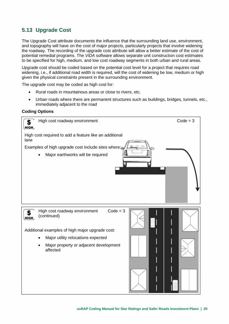
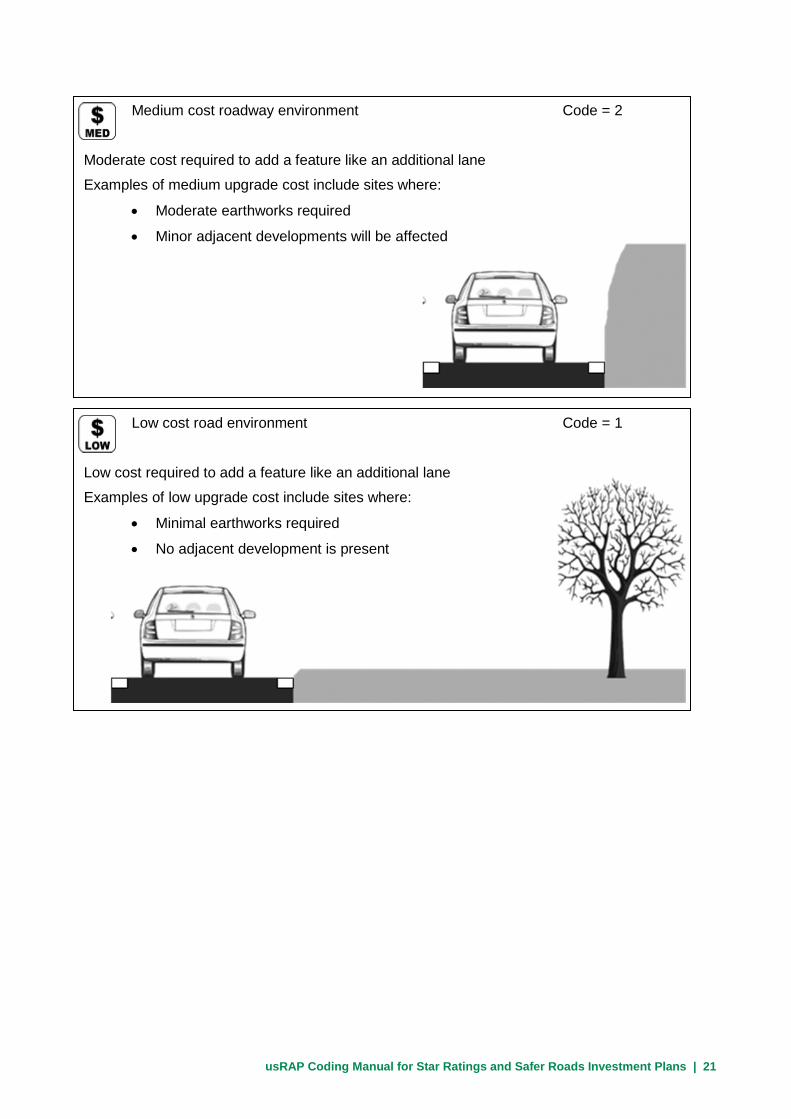
5.13 Upgrade Cost
The Upgrade Cost attribute documents the influence that the surrounding land use, environment, and topography will have on the cost of major projects, particularly projects that involve widening the roadway. The recording of the upgrade cost attribute will allow a better estimate of the cost of potential remedial programs. The ViDA software allows separate unit construction cost estimates to be specified for high, medium, and low cost roadway segments in both urban and rural areas.
Upgrade cost should be coded based on the potential cost level for a project that requires road widening, i.e., if additional road width is required, will the cost of widening be low, medium or high given the physical constraints present in the surrounding environment.
The upgrade cost may be coded as high cost for:
• Rural roads in mountainous areas or close to rivers, etc.
• Urban roads where there are permanent structures such as buildings, bridges, tunnels, etc., immediately adjacent to the road
Coding Options
High cost roadway environment Code = 3
High cost required to add a feature like an additional lane
Examples of high upgrade cost include sites where:
• Major earthworks will be required
High cost roadway environment Code = 3 (continued)
Additional examples of high major upgrade cost:
• Major utility relocations expected
• Major property or adjacent development affected
usRAP Coding Manual for Star Ratings and Safer Roads Investment Plans | 21
Medium cost roadway environment Code = 2
Moderate cost required to add a feature like an additional lane
Examples of medium upgrade cost include sites where:
• Moderate earthworks required
• Minor adjacent developments will be affected
Low cost road environment Code = 1
Low cost required to add a feature like an additional lane
Examples of low upgrade cost include sites where:
• Minimal earthworks required
• No adjacent development is present
usRAP Coding Manual for Star Ratings and Safer Roads Investment Plans | 22
5.14 Observed Motorcycle Flow
Observed Motorcycle Flow is not relevant to U.S. studies and should always be coded as 1 (which represents typical U.S. motorcycle flow of 1 to 5 percent of total traffic flow). This can be entered by the coders or added in post-processing at the option of the usRAP Team Leader. The estimated percentage of motorcycles in the traffic flow should be added to the upload file in post-processing (see the Guide to Producing usRAP Star Ratings and Safer Roads Investment Plans.).
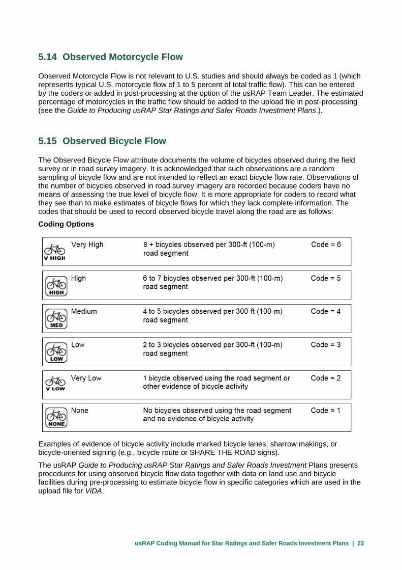
5.15 Observed Bicycle Flow
The Observed Bicycle Flow attribute documents the volume of bicycles observed during the field survey or in road survey imagery. It is acknowledged that such observations are a random sampling of bicycle flow and are not intended to reflect an exact bicycle flow rate. Observations of the number of bicycles observed in road survey imagery are recorded because coders have no means of assessing the true level of bicycle flow. It is more appropriate for coders to record what they see than to make estimates of bicycle flows for which they lack complete information. The codes that should be used to record observed bicycle travel along the road are as follows:
Coding Options
Examples of evidence of bicycle activity include marked bicycle lanes, sharrow makings, or bicycle-oriented signing (e.g., bicycle route or SHARE THE ROAD signs).
The usRAP Guide to Producing usRAP Star Ratings and Safer Roads Investment Plans presents procedures for using observed bicycle flow data together with data on land use and bicycle facilities during pre-processing to estimate bicycle flow in specific categories which are used in the upload file for ViDA.

usRAP Coding Manual for Star Ratings and Safer Roads Investment Plans | 23
Estimated bicycle flows based on observations of bicycle activity at any given location should generally be extended over a distance of 1.5 mi in both directions from the point where the bicycle activity was observed or throughout the road section in which bicyclists were observed.
In summary, the approach to rating bicycle flow is to code the number of bicyclists the coder sees and then convert the observation to a bicycle flow code in the pre-processing stage prior to data analysis.
5.16 Observed Pedestrian Flow—Crossing Road
The Observed Pedestrian Flow—Crossing Road attribute documents the pedestrian flow crossing the road observed during the field survey or in the road survey imagery.
The coding process will record the number of pedestrians observed crossing the road within each 300-ft (100-m) road segment. It is acknowledged that such observations are a random sampling of pedestrian activity and are not intended to reflect an exact pedestrian flow rate. Observations of the number of pedestrians crossing the road being surveyed are recorded because coders have no direct means of assessing the true level of pedestrian flow. It is more appropriate for coders to record what they see than to make estimates of pedestrian flow for which they lack complete information. The codes that should be used to record observed pedestrian crossing activity are as follows:
Coding Options
Examples of evidence of pedestrian crossing activity include a marked crosswalk, pedestrian crossing signs, the presence of a sidewalk on a side street intersecting the roadway being coded or a mailbox on one side of the road and residences or businesses on the other side.
Low 2 to 3 pedestrians observed crossing the road within a Code = 3 300-ft (100-m) road segment
Medium 4 to 5 pedestrians observed crossing the road within a Code = 4 300-ft (100-m) road segment
High 6 to 7 pedestrians observed crossing Code = 5 the road within a 300-ft (100-m) road segment
None No pedestrians observed crossing the road Code = 1 within a 300-ft (100-m) road segment and no evidence of pedestrian crossing activity
Very Low 1 pedestrian observed crossing the road Code = 2 within a 300-ft (100-m) road segment or other evidence of pedestrian crossing activity
Very High 8 + pedestrians observed crossing the road Code = 6 within a 300-ft (100-m) road segment

usRAP Coding Manual for Star Ratings and Safer Roads Investment Plans | 24
The Guide to Producing usRAP Star Ratings and Safer Roads Investment Plans presents procedures for using observed pedestrian crossing activity data together with data on land use and pedestrian facilities during pre-processing to estimate pedestrian crossing flow specific categories which are used in the upload file for ViDA.
In summary, the approach to rating pedestrian crossing flow is to code the number of pedestrians the coder sees crossing the road at any given location and then convert the observation to a pedestrian crossing flow in the pre-processing stage prior to data analysis.
5.17 Observed Pedestrian Flow—Along Road—Left Side
The Observed Pedestrian Flow—Along Road—Left Side attribute documents the pedestrian flow along the left side of the road observed during the field survey or in the road survey imagery.
The coding process will record the number of pedestrians walking along the road with each 300-ft (100-m) road segment. It is acknowledged that such observations are a random sampling of pedestrian activity and are not intended to reflect an exact pedestrian flow rate. Observations of the number of pedestrians walking along the road being surveyed are recorded because coders have no direct means of assessing the true level of pedestrian flow. It is more appropriate for coders to record what they see than to make estimates of pedestrian flow for which they lack complete information. The codes that should be used to record pedestrian travel along the left side of the road are as follows:
Coding Options
Low 1 pedestrian observed walking along the Code = 3 left side of the road within a 300-ft (100-m) road segment or evidence of pedestrian travel along the road
Very High 8 + pedestrians observed walking along Code = 6 the left side of the road within a 300-ft (100-m) road segment
High 6 to 7 + pedestrians observed walking along Code = 5 the left side of the road within a 300-ft (100-m) road segment
Medium - 4 to 5 pedestrians observed walking along Code = 4 the left side of the road within a 300-ft (100-m) road segment
Very Low 1 pedestrian observed walking along the Code = 2 left side of the road within a 300-ft (100-m) road segment or evidence of pedestrian travel along the road
xxxx No pedestrians observed walking along Code = 1 the left side of the road within a 300-ft (100-m) road segment and no evidence of pedestrian crossing activity

usRAP Coding Manual for Star Ratings and Safer Roads Investment Plans | 25
Examples of evidence of pedestrians walking along the road include the presence of a sidewalk or an informal footpath along the road, marked crosswalks for crossing side streets, or signing for pedestrians or children.
The Guide to Producing usRAP Star Ratings and Safer Roads Investment Plans presents procedures for using observed pedestrian travel activity together with data on land use and pedestrian facilities during pre-processing the estimate pedestrian crossing flow into specific categories which are used in the final upload file for ViDA.
Estimated pedestrian flows based on observations of pedestrian activity at any given location should generally be extended over a distance of 1.5 mi in both directions from the point where the pedestrian activity was observed or through the entire road section in which pedestrians were observed.
In summary, the approach to rating pedestrian flow is to code the number of pedestrians seen traveling along the road and then convert the observation to a pedestrian flow code in the pre-processing stage prior to data analysis.
5.18 Observed Pedestrian Flow—Along Road—Right Side
The Observed Pedestrian Flow—Along Road—Right Side attribute is coded for the right side of the road in a manner entirely analogous to the Observed Pedestrian Flow—Along Road—Left Side attribute (see Section 5.17).
usRAP Coding Manual for Star Ratings and Safer Roads Investment Plans | 26
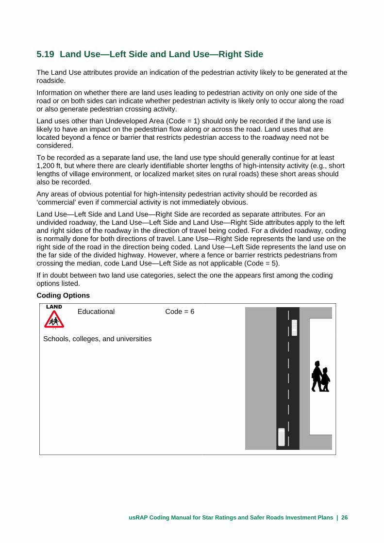
5.19 Land Use—Left Side and Land Use—Right Side
The Land Use attributes provide an indication of the pedestrian activity likely to be generated at the roadside.
Information on whether there are land uses leading to pedestrian activity on only one side of the road or on both sides can indicate whether pedestrian activity is likely only to occur along the road or also generate pedestrian crossing activity.
Land uses other than Undeveloped Area (Code = 1) should only be recorded if the land use is likely to have an impact on the pedestrian flow along or across the road. Land uses that are located beyond a fence or barrier that restricts pedestrian access to the roadway need not be considered.
To be recorded as a separate land use, the land use type should generally continue for at least 1,200 ft, but where there are clearly identifiable shorter lengths of high-intensity activity (e.g., short lengths of village environment, or localized market sites on rural roads) these short areas should also be recorded.
Any areas of obvious potential for high-intensity pedestrian activity should be recorded as ‘commercial’ even if commercial activity is not immediately obvious.
Land Use—Left Side and Land Use—Right Side are recorded as separate attributes. For an undivided roadway, the Land Use—Left Side and Land Use—Right Side attributes apply to the left and right sides of the roadway in the direction of travel being coded. For a divided roadway, coding is normally done for both directions of travel. Lane Use—Right Side represents the land use on the right side of the road in the direction being coded. Land Use—Left Side represents the land use on the far side of the divided highway. However, where a fence or barrier restricts pedestrians from crossing the median, code Land Use—Left Side as not applicable (Code = 5).
If in doubt between two land use categories, select the one the appears first among the coding options listed.
Coding Options
Educational Code = 6
Schools, colleges, and universities

usRAP Coding Manual for Star Ratings and Safer Roads Investment Plans | 27
Industrial and manufacturing Code = 7
Factories, industrial, and manufacturing facilities
Residential Code = 3
Residential/housing area
Commercial Code = 4
Shops or other commercial activity, or areas where high-intensity pedestrian activity is evident
Gas
Station

usRAP Coding Manual for Star Ratings and Safer Roads Investment Plans | 28
Farming and agricultural land Code = 2
Land devoted to crops or livestock
Note: Use Code = 5 for situations on divided highways where Land Use—Left Side is not applicable. Code = 5 should not be needed for Land Use—Right Side.
Undeveloped area Code = 1
Open land without shops, housing, or industry, or areas with developed land uses where a fence or barrier restricts pedestrian access to the roadway

usRAP Coding Manual for Star Ratings and Safer Roads Investment Plans | 29
5.20 Area Type
The Area Type attribute represents the level of roadside development through which the road is passing.
Roadside development that is considered in coding area type should be relatively close to the road and not separated from the road by a large fence or wall. Coding Options
Urban Code = 2
Continuous development for more than 300 ft
Includes urban development and rural town towns and villages
Rural Code = 1
All other areas not classified as urban
Areas where roadside development does not impact the operation of the road (e.g., when development is not close to the road or is separated from the road by a wall or fence)
Isolated development less than 300 ft in length along a road otherwise classified as rural

usRAP Coding Manual for Star Ratings and Safer Roads Investment Plans | 30
5.21 Speed Limit
The actual posted numerical speed limit in mph should be coded. For example, if the posted speed limit is 55 mph, enter the value 55. Do not enter the abbreviation mph or any other text for this attribute. In the pre-processing stage this will be converted to a speed code.
Do not attempt to determine the actual speed of the traffic using the road as part of the coding process. If no speed limit is signed, the default speed limit set by law for that particular type of road should be used. The default legal speed limit should be determined from discussions with highway agency staff. If no speed limit is posted and the coder is unsure what default legal speed limit is applicable, leave the speed limit field blank. Any speed limit codes left blank must be filled in during the pre-processing stage.
Consider only regulatory maximum speed limits. Do not record advisory speeds, such as those posted on curve warning signs. Regulatory speed limits are those posted on black-and-white signs; advisory speeds are posted on black-and-yellow signs. speed limits. Do not record advisory or regulatory speeds that apply for only a portion of the day (such as school zone speed limits). Advising speed limits may be noted in the Comments field (see Section 5.11).
If available, the actual mean and/or 85th percentile operating speed of traffic on the roadway in question or on similar roadways can be added as a separate attribute in pre-processing This should be done in pre-processing and not during the coding process.
5.22 Motorcycle Speed Limit
Since there are no separate motorcycle speed limits in the United States, this attribute should be left blank by coders. In pre-processing, this attribute will be set equal to the general speed limit (see Section 5.21).
5.23 Truck Speed Limit
If a truck speed limit that differs from the general speed limit is posted (or applies as a matter of law), code the numerical speed limit in mph. Do not enter the abbreviation mph or any other text for this attribute. If the speed limit applicable to trucks is the same as the general speed limit, leave this field blank. Any blank speed limits will be automatically filled in and the Differential Speed Limit attribute will be set in the pre-processing stage.

usRAP Coding Manual for Star Ratings and Safer Roads Investment Plans | 31
5.24 Median Type
The Median Type attribute documents the type of road infrastructure that separates the two opposing traffic flows.
The manner in which opposing flows are separated affects the likelihood of severe crashes. Traffic barriers restrict the movement of errant vehicles across the median and physical medians reduce the potential for head-on impacts by making it less likely that errant vehicles reach opposing traffic before they recover.
Where an obviously inadequate or defective traffic barrier is present in the median such that a vehicle is likely break through the barrier on impact, code the median as if no traffic barrier exists. Examples of poor barriers are those with sub-standard materials; or broken, unrepaired, or poorly maintained railings.
If a traffic barrier has poorly designed ends (e.g., turned down ends that can launch a vehicle into the air or untreated ends that can spear a vehicle), the barrier ends should be coded as aggressive objects in the Roadside Severity Object-Right Side or Roadside Severity Object-Left Side attributes, as appropriate (see Sections 5.27 and 5.29).
Where a traffic barrier is present in the median, it should be recorded for both Median Type and Roadside Severity Object-Left Side attributes, unless there is an aggressive object in front of the barrier. In this situation, the Median Type would be traffic barrier and Roadside Severity Object–Left Side would be based on the type of object in front of the barrier.
Coding Options
Wide centreline (1 to 3 ft) Code = 14
Road with a wide double centerline with spacing of 1 to 3 ft between the centerlines (or very narrow flush median with only 1 to 3 ft between the left edgelines of the opposing roadways)
Centerline only Code = 11
Single or double centerline, or marked central strip less than 3 ft in width
If the road is undivided and has no markings, it should be recorded as:
Median Type = centerline only
Delineation = poor

usRAP Coding Manual for Star Ratings and Safer Roads Investment Plans | 32
Central hatching Code = 10
Marked central strip greater than 3 ft wide
Examples of marking are:
• Pavement stripes
• Colored paving
Continuous central turning lane Code = 8
Continuous central lane designated as a left-turn lane (i.e., two-way left-turn lane or TWLTL)
Flexible posts Code = 9
Roadway with flexible posts between opposing lanes, but no continuous physical divider.

usRAP Coding Manual for Star Ratings and Safer Roads Investment Plans | 33
Physical median width less than 3 ft Code = 7
Divided road with physical median of surface type different from the traveled way surface with width less than 3 ft
0-3 ft
Physical median width 3 to 15 ft Code = 6
Divided road with physical median of surface type different from the traveled way surface with width 3 to 15 ft
3-15 ft
Physical median width 15 to 30 ft Code = 5
Divided road with physical median of surface type different from the traveled way surface with width 15 to 30 ft
15-30 ft

usRAP Coding Manual for Star Ratings and Safer Roads Investment Plans | 34
Traffic barrier - concrete Code = 2
Divided road with concrete median barrier constructed to accepted standards
If the barrier is obviously defective, code the median type as though there is no barrier present.
Traffic barrier - metal Code = 1
Divided road with a median barrier consisting of metal guardrail, designed to accepted standards.
If the barrier is obviously defective, code the median type as if there is no barrier present.
Motorcycle friendly barrier Code = 12
Divided road with traffic barrier designed to accepted standard that will also minimize impact to motorcyclists
Motorcycle friendly barriers have some form of protection to prevent motorcycists from striking the supporting posts
Note: There are few, if any, motorcycle-friendly barriers in current use; this code should be used sparingly, if at all

usRAP Coding Manual for Star Ratings and Safer Roads Investment Plans | 35
Traffic barrier - cable Code = 15
Divided road with cable median barrier designed to accepted standards
If the barrier is obviously defective, code the median type as though there is no barrier present.
Physical median width greater than 65 ft Code = 3
Divided road with physical median of surface type different from the traveled way surface with width greater than 65 ft
>65 ft
Physical median width 30 to 65 ft Code = 4
Divided road with physical median of surface type different from the travelled way surface with width between 30 and 65 ft
30-65 ft

usRAP Coding Manual for Star Ratings and Safer Roads Investment Plans | 36
5.25 Centerline Rumble Strip
The Centerline Rumble Strip attribute indicates the presence or absence of a centerline rumble strip on an undivided roadway.
Coding Options
Not present Code = 1
An undivided road with no centerline rumble strip or any divided road
Present Code = 2
An undivided road with a centerline rumble strip present
Not applicable (one-way road) Code = 13
Use this code for one-way streets only. This code is NOT used for roadways of a divided highway.

usRAP Coding Manual for Star Ratings and Safer Roads Investment Plans | 37
5.26 Roadside Severity Distance—Right Side
While roadside severity for the left side of the road appears before the roadside severity for the right side of the road in the upload file for the Volume 3.0 ViDA software, it is most convenient to describe the right side attributes first, and then explain the manner in which the left side attributes differ from the right side. Therefore, the material on roadside severity appears here in that order. It is important to assure that the left side attributes appear first in the actual upload file.
The Roadside Severity Distance—Right Side attribute represents the distance from the right edge of the traveled way to the most severe roadside object that could be struck by an errant vehicle on the right side of the roadway. The type of the severe roadside object whose distance from the traveled way is coded here should be coded for the Roadside Severity Object—Left Side attribute (see Section 5.27). A severe object is any object that could result in serious injury to a car occupant if struck by an errant vehicle. Examples of potential severe objects include:
• Boulders higher than 8 in
• Nonfrangible poles/posts or trees with diameter greater than 4 in
• Unprotected structures that may cause rapid deceleration when struck (including traffic barriers)
• Aggressive ends to traffic barriers (i.e., barrier ends without an appropriate end treatment)
Steep embankments, deep drainage ditches, or large vertical drops (cliffs) are also considered to be severe objects. The full range of severe roadside objects that should be considered in coding is presented below in Section 5.27.
Roadside hardware with a frangible or breakaway design is not considered a severe object. Code such situations as if the frangible or breakaway object was not present.
The roadside severity for each side of the roadway is coded separately (see Sections 5.28 and 5.29 for coding roadside severity for the left side of the road).
NOTE: Where no severe object is present on the roadside, but a steep embankment or cliff is present, code the distance from the outside edge of the traveled way to the beginning of the embankment slope or to the top of the cliff.
NOTE: Where more than one severe object is present on the roadside and the object closer to the roadway would be struck by an errant vehicle before the errant vehicle would encounter the farther object, code the distance to the closer object. For example, if a cliff is located behind a guardrail or behind a row of closely spaced trees, code the distance from the outside edge of the traveled way to the guardrail or trees.
NOTE: If a severe object is located on a steep embankment foreslope or fill slope just before the upper threshold of one of the distance categories shown below (3, 15, or 30 ft from the outside edge of the traveled way), code the next higher distance category. Similarly, if a severe object is located on a steep upslope or cut slope just beyond the upper threshold of one of the distance categories shown below (3, 15, or 30 ft from the outside edge of the traveled way), code the next lower distance category.

usRAP Coding Manual for Star Ratings and Safer Roads Investment Plans | 38
Distance to roadside object 0 to 3 ft Code = 1
Objects within 0 to 3 ft of the outside edge of the traveled way
Distance to roadside object 3 to 15 ft Code = 2
Objects within 3 to 15 ft of the outside edge of the traveled way
Distance to roadside object 15 to 30 ft Code = 3
Objects within 15 to 30 ft of the outside edge of the traveled way

usRAP Coding Manual for Star Ratings and Safer Roads Investment Plans | 39
Distance to roadside object greater than 30 ft Code = 4
Objects more than 30 ft from the outside edge of the traveled way
5.27 Roadside Severity Object—Right Side
The Roadside Severity Object—Right Side attribute documents the type of object whose distance from the outside of the traveled way was coded for the Roadside Severity Distance—Right Side attribute (see Section 5.26).
Coding Options
Cliff Code = 10
Cliff with a substantial vertical drop or any equivalent hazard that is likely to result in certain fatality if traversed by a vehicle regardless of vehicle speed
NOTE: Vertical drops that are not likely to result in a certain fatality should be treated as steep embankment slopes, not as cliffs. If a traffic barrier or a series of aggressive objects is located between the traveled way and a cliff such that an errant vehicle would be likely to collide with and be stopped by those objects before reaching the cliff, do not use the cliff code.
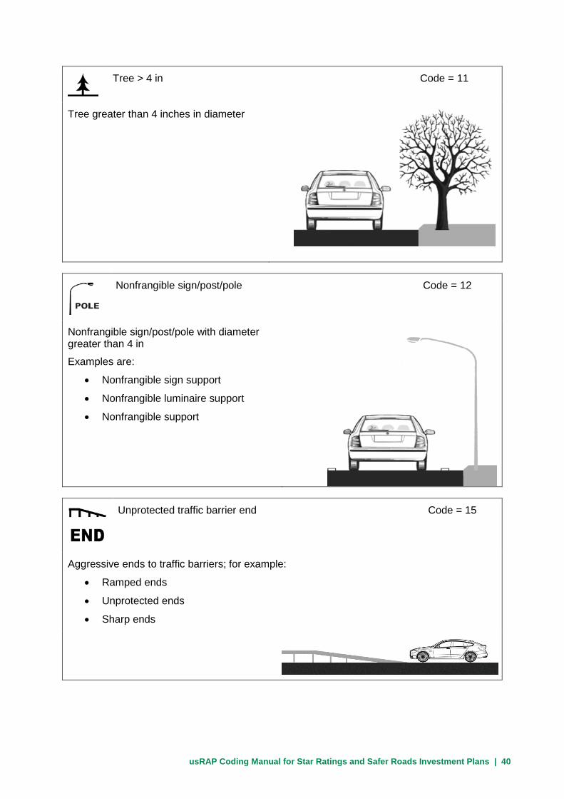
usRAP Coding Manual for Star Ratings and Safer Roads Investment Plans | 40
Tree > 4 in Code = 11
Tree greater than 4 inches in diameter
Nonfrangible sign/post/pole Code = 12
Nonfrangible sign/post/pole with diameter greater than 4 in
Examples are:
• Nonfrangible sign support
• Nonfrangible luminaire support
• Nonfrangible support
Unprotected traffic barrier end Code = 15
Aggressive ends to traffic barriers; for example:
• Ramped ends
• Unprotected ends
• Sharp ends

usRAP Coding Manual for Star Ratings and Safer Roads Investment Plans | 41
Aggressive vertical face Code = 5
Aggressive vertical face, such as a rock cut
Upwards slope (15⁰ to 75⁰) Code = 6
Cut slope at least 6 ft in height that is likely to cause a vehicle to roll over.
Examples are:
• Earth embankments
• Grass-covered embankments
NOTE: Irregular rock faces should be recorded using Code 5
Deep drainage ditch Code = 8
Ditch or culvert of material, depth, or severity of angled face likely to result in severe injury to vehicle occupants.
Rule of thumb
Only record a ditch if most of the vehicle would drop into the ditch.

usRAP Coding Manual for Star Ratings and Safer Roads Investment Plans | 42
Downwards slope (> -15⁰) Code = 9
Downwards slope from the roadway with:
>1:4 slope and vertical drop > 3 ft
Rule of thumb
A slope should be recorded only if a vehicle is likely to roll over on it
Large boulders (> 8 in high) Code = 16
Rocks higher than 8 in
Rigid structure/bridge or building Code = 13
Structures that will cause a rapid vehicle deceleration when hit by a vehicle

usRAP Coding Manual for Star Ratings and Safer Roads Investment Plans | 43
Semi-rigid structure or building Code = 14
Structures that will not cause a rapid vehicle deceleration when hit by a vehicle
Traffic barrier – concrete Code = 2
Concrete traffic barrier sufficient to restrain
most cars and small vehicles
If the barrier is obviously defective, code as though there is no barrier present
Traffic barrier - metal Code = 1
Metal guardrail sufficient to restrain most cars and small vehicles
If the barrier is obviously defective, code as though there is no barrier present.
NOTE: Cable barriers, although metal, are recorded with Code 4.

usRAP Coding Manual for Star Ratings and Safer Roads Investment Plans | 44
Traffic barrier - cable Code = 4
Cable barrier sufficient to restrain most cars and small vehicles
If the barrier is obviously defective, code as though there is no barrier present.
Traffic barrier – motorcycle friendly Code = 3
Traffic barrier designed to accepted standard that will also minimize impact to motorcyclists Motorcycle friendly barriers have some form of protection for the supporting posts
NOTE: There are few, if any, motorcycle friendly barriers in current use; this code should be used sparingly, if at all.
Upwards slope (≥ 75⁰) Code = 7
Steep cut slope or near-vertical face of at least 6-ft height that a vehicle is likely to slide along, rather than roll over, when struck
Examples are:
• Earth embankments
• Grass embankments
NOTE: Irregular rock faces should be recorded using Code 5
usRAP Coding Manual for Star Ratings and Safer Roads Investment Plans | 45
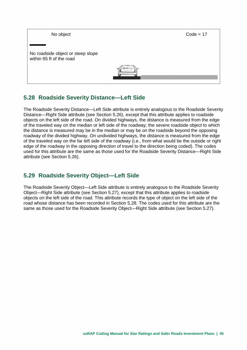
No object Code = 17
No roadside object or steep slope within 65 ft of the road
5.28 Roadside Severity Distance—Left Side
The Roadside Severity Distance—Left Side attribute is entirely analogous to the Roadside Severity Distance—Right Side attribute (see Section 5.26), except that this attribute applies to roadside objects on the left side of the road. On divided highways, the distance is measured from the edge of the traveled way on the median or left side of the roadway; the severe roadside object to which the distance is measured may be in the median or may be on the roadside beyond the opposing roadway of the divided highway. On undivided highways, the distance is measured from the edge of the traveled way on the far left side of the roadway (i.e., from what would be the outside or right edge of the roadway in the opposing direction of travel to the direction being coded). The codes used for this attribute are the same as those used for the Roadside Severity Distance—Right Side attribute (see Section 5.26).
5.29 Roadside Severity Object—Left Side
The Roadside Severity Object—Left Side attribute is entirely analogous to the Roadside Severity Object—Right Side attribute (see Section 5.27), except that this attribute applies to roadside objects on the left side of the road. This attribute records the type of object on the left side of the road whose distance has been recorded in Section 5.28. The codes used for this attribute are the same as those used for the Roadside Severity Object—Right Side attribute (see Section 5.27).

usRAP Coding Manual for Star Ratings and Safer Roads Investment Plans | 46
5.30 Shoulder Rumble Strips
The Shoulder Rumble Strips attribute represents any indentations or textured markings (of depth or height greater than 0.4 in) running longitudinally along the right shoulder of a road whose function is to create vibration or noise at the tire-pavement interface to warn drivers that their vehicle is leaving the traveled way.
Edgeline rumble strips or rumble stripes are coded as shoulder rumble strips in this category.
Centerline rumble strips should not be recorded here (see Section 5.25 for coding of centerline rumble strips).
Rumble strips are generally found only on paved shoulders; edgeline rumble strips or rumble stripes may also be found at the edge of the traveled way adjacent to unpaved shoulders.
Coding Options
No – shoulder rumble strips are not present Code = 1
Yes – shoulder rumble strips are present Code = 2
Only rumble strips that are greater than approximately 0.4 inches in depth or height should be recorded.

usRAP Coding Manual for Star Ratings and Safer Roads Investment Plans | 47
5.31 Paved Shoulder Width—Left Side and Paved Shoulder Width—Right Side
The Paved Shoulder Width—Left Side and Paved Shoulder Width—Right Side attributes represent the width of the safe and drivable hard-surfaced section of roadway outside of the edgeline or outside of the traveled way. Shoulder width is measured from the center of the edgeline marking to the outside edge of the paved roadway or from the outside edge of the traveled way to the outside edge of the paved roadway. If paving has begun to break up on a shoulder, the paved shoulder width should be measured up to where the broken pavement begins
The width of unpaved shoulders are not recorded here, but where appropriate may be recorded as an informal pedestrian path (see Sections 5.52 and 5.53). If only an uppaved shoulder is present, the paved-shoulder width should be coded as zero.
The Paved Shoulder Width—Right Side, attribute is the paved shoulder width on the outside shoulder on the right side of the roadway being coded. On an undivided roadway, the Paved Shoulder Width—Left Side attribute is the paved-shoulder width of the outside shoulder on the left side of the roadway (i.e., the right shoulder in the opposing direction of travel). The coding options illustrated below are those for undivided roadways. On a divided highway, the Paved Shoulder Width-Left Side attribute is the paved shoulder width of the left or median shoulder of the roadway being coded. The codes (i.e., width categories) used for paved shoulder width on divided highways are the same as those used for undivided roadways.
Coding Options
None Code = 4
There is no paved shoulder
0 ft 0 ft

usRAP Coding Manual for Star Ratings and Safer Roads Investment Plans | 48
Less than 3 ft wide Code = 3
Paved shoulder width is less than 3 ft
0-3 ft 0-3 ft
3 to 7.9 ft wide Code = 2
Paved shoulder width is 3 to 7.9 ft
3-7.9 ft 3-7.9 ft
More than 7.9 ft wide Code = 1
Paved shoulder width is greater than 7.9 ft
>7.9 ft >7.9 ft
usRAP Coding Manual for Star Ratings and Safer Roads Investment Plans | 49
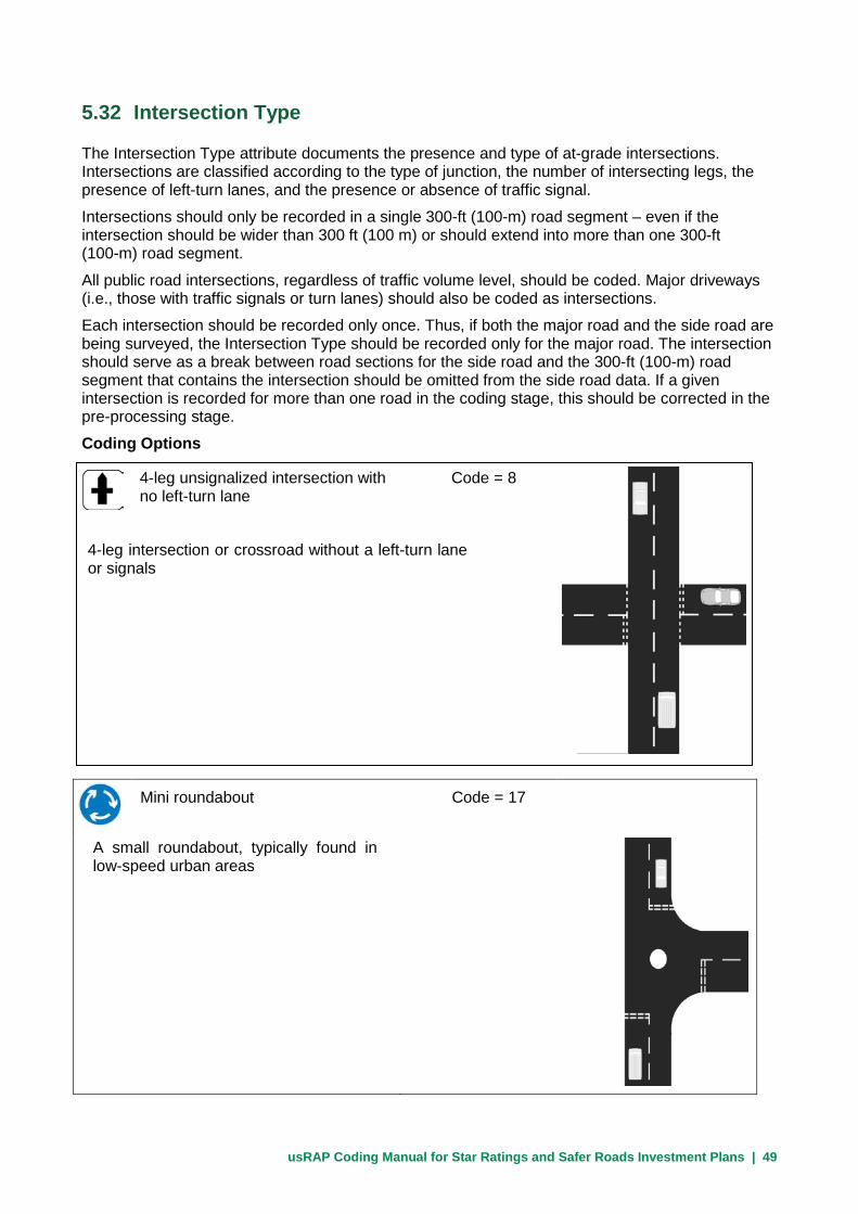
5.32 Intersection Type
The Intersection Type attribute documents the presence and type of at-grade intersections. Intersections are classified according to the type of junction, the number of intersecting legs, the presence of left-turn lanes, and the presence or absence of traffic signal.
Intersections should only be recorded in a single 300-ft (100-m) road segment – even if the intersection should be wider than 300 ft (100 m) or should extend into more than one 300-ft (100-m) road segment.
All public road intersections, regardless of traffic volume level, should be coded. Major driveways (i.e., those with traffic signals or turn lanes) should also be coded as intersections.
Each intersection should be recorded only once. Thus, if both the major road and the side road are being surveyed, the Intersection Type should be recorded only for the major road. The intersection should serve as a break between road sections for the side road and the 300-ft (100-m) road segment that contains the intersection should be omitted from the side road data. If a given intersection is recorded for more than one road in the coding stage, this should be corrected in the pre-processing stage.
Coding Options
Mini roundabout Code = 17
A small roundabout, typically found in low-speed urban areas
4-leg unsignalized intersection with Code = 8 no left-turn lane
4-leg intersection or crossroad without a left-turn lane or signals

usRAP Coding Manual for Star Ratings and Safer Roads Investment Plans | 50
4-leg unsignalized intersection Code = 7 with left-turn lane
4-leg intersection or crossroad with a left-turn lane but no signals. At a 4-leg intersection traffic from the side road may cross the major road.
4-leg signalized intersection with Code = 10 no left-turn lane
4-leg intersection or crossroad with signals but no turn lane. At a 4-leg intersection traffic from the side road may cross the major road.
Railway crossing – passive control Code = 13
A railroad-highway grade crossing with signage only (or with no signage), but without active flashing lights or automatic gates.
usRAP Coding Manual for Star Ratings and Safer Roads Investment Plans | 51
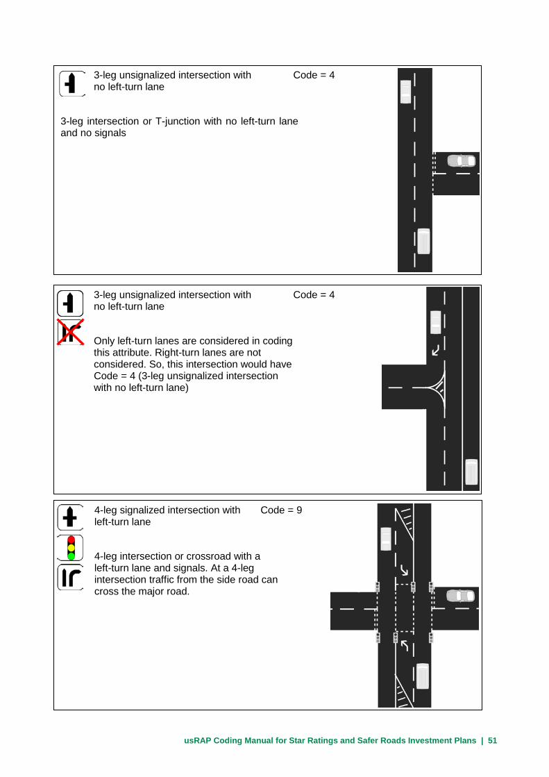
3-leg unsignalized intersection with Code = 4 no left-turn lane
3-leg intersection or T-junction with no left-turn lane and no signals
3-leg unsignalized intersection with Code = 4 no left-turn lane
Only left-turn lanes are considered in coding this attribute. Right-turn lanes are not considered. So, this intersection would have Code = 4 (3-leg unsignalized intersection with no left-turn lane)
4-leg signalized intersection with Code = 9 left-turn lane
4-leg intersection or crossroad with a left-turn lane and signals. At a 4-leg intersection traffic from the side road can cross the major road.

usRAP Coding Manual for Star Ratings and Safer Roads Investment Plans | 52
3-leg signalized intersection with Code = 6 no left-turn lane
3-leg intersection or T-junction with signals but no left-turn lane
3-leg signalized intersection with Code = 5 left-turn lane
3-leg intersection or T-junction with a left-turn lane and signals
3-leg unsignalized intersection with Code = 3 left-turn lane
3-leg intersection or T-junction with a left-turn lane but no signals

usRAP Coding Manual for Star Ratings and Safer Roads Investment Plans | 53
Railway crossing – active control Code = 14
A railroad-highway grade crossing with a physical device to warn of an approaching train (flashing lights and/or automatic gates)
Merge lane Code = 1
Traffic joins the road being surveyed from the side via a merge or acceleration lane. This is typically applicable to on-ramps at grade-separated interchanges.
If the merge or acceleration lane is longer than 300 ft (100 m) it should still be recorded only once.
Merge or acceleration lanes at channelized intersections are not recorded if the intersection is recorded using one of the codes given above.
Roundabout Code = 2
All roundabouts except mini-roundabouts

usRAP Coding Manual for Star Ratings and Safer Roads Investment Plans | 54
Median crossing – no turn lanes Code = 15
For divided roads only, this code is used for high-demand U-turn locations that have no acceleration or deceleration lanes and/or has a pavement surface in poor condition
Median crossing – with turn lanes Code = 16
For divided roads only, this code is used for a high demand U-turn location that has appropriate acceleration and deceleration lanes and has a pavement surface in good condition
Merge lane
Diverge or deceleration lanes are not coded. Nothing is recorded concerning off-ramps.

usRAP Coding Manual for Star Ratings and Safer Roads Investment Plans | 55
5.33 Intersection Channelization
The Intersection Channelization attribute documents whether there are raised or colored islands present at an intersection to designate intended vehicle paths through the intersection.
Intersection channelization includes:
• Median islands and splitter islands
• Islands that separate offset turn lanes from through traffic lanes
• Islands that separate turning roadways from through traffic lanes
Coding Options
The coding options for intersection channelization are:
Code Description 1 Not present 2 Present
Note: Use Code = 1 (not present) at locations where no intersection is present as well as at intersections without channelization.
None Code = 12
No intersection present within 300-ft (100-m) road section

usRAP Coding Manual for Star Ratings and Safer Roads Investment Plans | 56
5.34 Intersecting Road Volume
An estimate of the traffic volume of the intersecting road (i.e., side road) is recorded for the Intersecting Road Volume attribute.
The Intersecting Road Volume attribute should be determined from highway agency records of side-road traffic volumes whenever these are available. When no data are available, an appropriate estimate should be made (see guidelines below). A typical approach is to code the Intersecting Road Volume attribute visually and then update it, as appropriate, in the pre-processing stage.
If there is no intersection present, record the Intersecting Road Volume as ‘not applicable’ (Code = 7).
Coding Options
Very high Code = 1
Over 15,000 vehicles per day
Where traffic volume or local knowledge is not available, assume ‘very high’ intersecting road volume for all intersections where the side road is a divided road with three or more lanes provided for side road traffic in each direction of travel
High Code = 2
10,000 to 15,000 vehicles per day
Where traffic volume or local knowledge is not available, assume ‘high’ intersecting road volume for all intersections where the side road is an undivided road with three or more lanes provided for side road traffic in each direction of travel

usRAP Coding Manual for Star Ratings and Safer Roads Investment Plans | 57
Medium high Code = 3
5,000 to 10,000 vehicles per day
Where volume data or local knowledge is not available assume ‘medium high’ for all intersections where the side road is divided or undivided and has two lanes in each direction of travel
Low Code = 5
100 to 1,000 vehicles per day
Where volume data or local knowledge is not available, assume ‘low’ for all intersections where the side road is unpaved or is a local residential street
In small villages, assume all side roads are ‘low’ or ‘very low’ volume unless there is evidence to the contrary
Medium Code = 4
1,000 to 5,000 vehicles per day
Where volume data or local knowledge is not available assume ‘medium’ for all intersections where the side road is paved and there is only one lane for side road traffic in each direction of travel, and a left-turn lane is provided on the major road, unless the side road is a local residential street
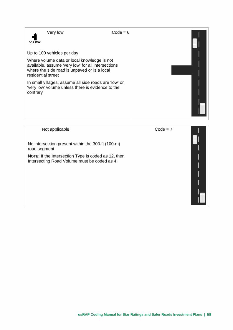
usRAP Coding Manual for Star Ratings and Safer Roads Investment Plans | 58
Very low Code = 6
Up to 100 vehicles per day
Where volume data or local knowledge is not available, assume ‘very low’ for all intersections where the side road is unpaved or is a local residential street
In small villages, assume all side roads are ‘low’ or ‘very low’ volume unless there is evidence to the contrary
Not applicable Code = 7
No intersection present within the 300-ft (100-m) road segment
NOTE: If the Intersection Type is coded as 12, then Intersecting Road Volume must be coded as 4

usRAP Coding Manual for Star Ratings and Safer Roads Investment Plans | 59
5.35 Intersection Quality
The Intersection Quality attribute documents the quality of the intersection design features, the advance warning, signing, and markings, and the sight distance to the intersection for approaching vehicles.
Intersection Quality should be rated as ‘adequate’ for those intersections where advance warning, signing, and making are present and in good condition and where adequate intersection design features and sight distance are present.
Factors resulting in a ‘poor’ code for Intersection Quality may include:
• Very short merge lanes
• Poor deflection angles at roundabouts approaches such that the roundabout can be entered at high speeds
• Lack of advance signing and marking on an intersection approach, particularly where the intersection is not clearly visible to approaching drivers (i.e., where approach sight distance is limited.)
If there is no intersection present, record the intersection quality as ‘not applicable’ (Code = 3).
Coding Options
Adequate Code = 1
Intersection design is adequate and needed signing and marking is generally present
Poor Code = 2
Intersection design is poor or signs and markings needed on approaches with limited sight distance are absent

usRAP Coding Manual for Star Ratings and Safer Roads Investment Plans | 60
Not applicable Code = 3
No intersection is present within the 300-ft (100-m) road segment.
Note: If the Intersection Type is coded as 12, then Intersection Quality must be coded as 3.
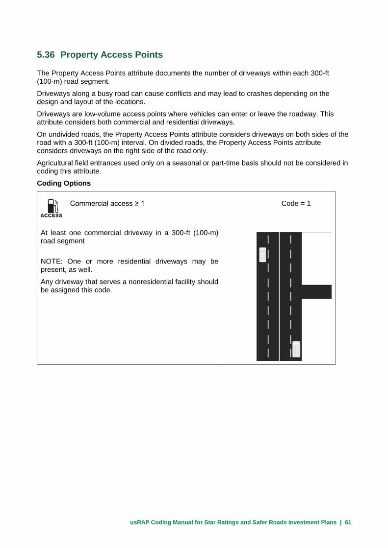
usRAP Coding Manual for Star Ratings and Safer Roads Investment Plans | 61
5.36 Property Access Points
The Property Access Points attribute documents the number of driveways within each 300-ft (100-m) road segment.
Driveways along a busy road can cause conflicts and may lead to crashes depending on the design and layout of the locations.
Driveways are low-volume access points where vehicles can enter or leave the roadway. This attribute considers both commercial and residential driveways.
On undivided roads, the Property Access Points attribute considers driveways on both sides of the road with a 300-ft (100-m) interval. On divided roads, the Property Access Points attribute considers driveways on the right side of the road only.
Agricultural field entrances used only on a seasonal or part-time basis should not be considered in coding this attribute.
Coding Options
Commercial access ≥ 1 Code = 1
At least one commercial driveway in a 300-ft (100-m) road segment
NOTE: One or more residential driveways may be present, as well.
Any driveway that serves a nonresidential facility should be assigned this code.

usRAP Coding Manual for Star Ratings and Safer Roads Investment Plans | 62
Residential Access ≥ 3 Code = 2
Three or more residential driveways in a 300-ft (100-m) road segment
No driveway access Code = 4
No driveways of any type within a 300-ft (100-m) road segment
Note: If an intersection is present within a 300-ft (100-m) road segment, that intersection should be recorded under the Intersection Type attribute (see Section 5.32), not the Property Access Points attribute.
Residential Access < 3 Code = 3
1 or 2 residential driveways in a 300-ft (100-m) road segment

usRAP Coding Manual for Star Ratings and Safer Roads Investment Plans | 63
5.37 Number of Lanes for Use by Though Traffic
The Number of Lanes for Use by Through Traffic attribute represents the total number of lanes in one direction of travel.
The number of lanes recorded should reflect the predominant character of the road, and changes in the number of lanes present over short lengths of road (less than 1,300 ft or 400 m) should not be recorded.
Only lanes that serve through traffic should be considered; turning lanes or short auxiliary lanes should not be considered.
The coded value of the number of lanes used by through traffic should represent
• Half of the total number of lanes on a two-way undivided road (i.e., Carriageway C)
• The total number of lanes on a one-way undivided road (i.e., Carriageway C)
• The total number of lanes on one roadway of a divided highway being rated separately from the other roadway (i.e., Carriageway A or B)
Note: Special codes are used for undivided roadways with differing numbers of lanes in the opposing directions of travel (See 3+2 and 2+1 facilities below.)
Coding Options
Four or more Code = 4
Four or more through lanes per direction of travel

usRAP Coding Manual for Star Ratings and Safer Roads Investment Plans | 64
Two Code = 2
Two through lanes per direction of travel
Three Code = 3
Three through lanes per direction of travel
3+2 lanes Code = 6
Three through lanes in one direction of travel and two through lanes in the other direction of travel

usRAP Coding Manual for Star Ratings and Safer Roads Investment Plans | 65
Any other unbalanced number of lanes should be classified based on the maximum number of through lanes in either direction of travel.
One Code = 1
One through lane per direction of travel
2+1 lane road Code = 5
Two through lanes in one direction of travel and one through lane in the other direction of travel
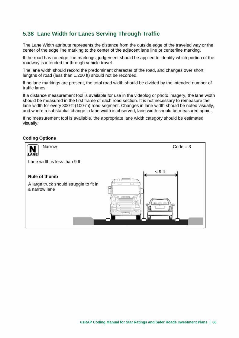
usRAP Coding Manual for Star Ratings and Safer Roads Investment Plans | 66
5.38 Lane Width for Lanes Serving Through Traffic
The Lane Width attribute represents the distance from the outside edge of the traveled way or the center of the edge line marking to the center of the adjacent lane line or centerline marking.
If the road has no edge line markings, judgement should be applied to identify which portion of the roadway is intended for through vehicle travel.
The lane width should record the predominant character of the road, and changes over short lengths of road (less than 1,200 ft) should not be recorded.
If no lane markings are present, the total road width should be divided by the intended number of traffic lanes.
If a distance measurement tool is available for use in the videolog or photo imagery, the lane width should be measured in the first frame of each road section. It is not necessary to remeasure the lane width for every 300-ft (100-m) road segment. Changes in lane width should be noted visually, and where a substantial change in lane width is observed, lane width should be measured again.
If no measurement tool is available, the appropriate lane width category should be estimated visually.
Coding Options
Narrow Code = 3
Lane width is less than 9 ft
Rule of thumb
A large truck should struggle to fit in a narrow lane
< 9 ft
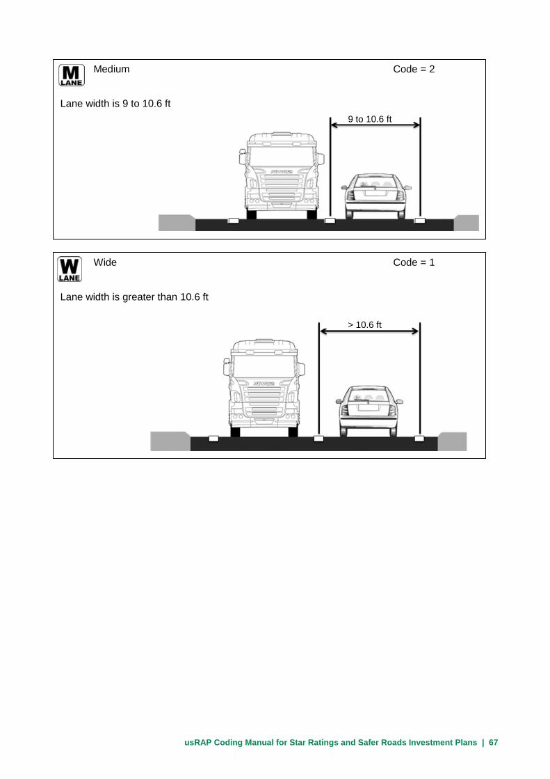
usRAP Coding Manual for Star Ratings and Safer Roads Investment Plans | 67
Medium Code = 2
Lane width is 9 to 10.6 ft
9 to 10.6 ft
Wide Code = 1
Lane width is greater than 10.6 ft
> 10.6 ft

usRAP Coding Manual for Star Ratings and Safer Roads Investment Plans | 68
5.39 Curvature
The Curvature attribute represents the horizontal alignment of the road.
The coded alignment should be based on the appropriate safe approach speed for normal conditions.
If there is an advisory speed sign, use the speed on the sign for rating the horizontal alignment.
The default value for curvature is ‘straight or gently curving’; this means that where there is no curve ‘straight or gently curving’ should be recorded.
Use the same Curvature code in any 300-ft (100-m) road segment that contains any portion of a specific curve.
The Curvature can also be determined from sensors built into a data collection vehicle, such as accelerometer and gyrosope data. In this case, the curvature data should be added in pre-processing, not by the coder.
It is not advisable to use the driven speed of the vehicle that recorded the videos of the roadway for determining horizontal alignment since the vehicle speed can be affected by other factors like traffic flow.
Coding Options
Very sharp Code = 4
The road contains a very sharp curve which can only be driven at less than 25 mph
Sharp Code = 3
The road has a sharp curve which can be driven at a maximum speed between 25 and 45 mph

usRAP Coding Manual for Star Ratings and Safer Roads Investment Plans | 69
5.40 Quality of Curve
The Quality of Curve attribute represents how easy it is for approaching drivers to judge how sharp a horizontal curve is and what speed should be chosen to safety traverse the curve. Assessment of the Quality of Curve attribute is based on the visual appearance of the curve to approaching drivers and the sight distance on the approach to, and around, the curve, but should also reflect the extent to which signs and markings are present to help the driver judge the correct speed for the curve.
Features of a curve that help drivers judge the curve radius and select the correct speed include:
• Advance warning signs
• Advance warning signs with advisory speed plates
• Chevron markers
Moderate Code = 2
The road has a moderate curve which can be driven at a maximum speed of 45 to 60 mph
Straight or gently curving Code = 1
The road is straight (tangent) or contains only long-radius curves which can be driven at 60 mph or more

usRAP Coding Manual for Star Ratings and Safer Roads Investment Plans | 70
• Adequate edgeline, lane line, and/or centerline markings
• Adequate sight distance in advance of, and around, the curve
A practical indication of a poor quality curve might be whether it appears that the driver might need to adjust speed rapidly or unexpectedly on the approach to, or within, the curve. This may occur even though there has been some attempt through signing to warn the driver of extra risk.
The quality of the curve should be judged as adequate unless there is an obvious deficiency.
Coding Options NOTE: On a tangent roadway with no horizontal curve present, the Quality of Curve attribute should be coded as 3 (not applicable).
Poor Code = 2
Rapid or unexpected speed adjustments are needed to negotiate the curve without appropriate traffic control devices or sight distance
Adequate Code = 1
Signing, marking, and sight distance enable a driver to judge curvature and adjust speed appropriately

usRAP Coding Manual for Star Ratings and Safer Roads Investment Plans | 71
5.41 Grade
The Grade attribute is based on the longitudinal percent grade of the roadway. Most roadways, except in very steep terrain, fall within Code 1 for the Grade attribute (0 to 7.5 percent). The Grade attribute is not affected by whether the grade is an upgrade or downgrade (of course, on an undivided road, the grade is by definition an upgrade in one direction of travel and a downgrade in the other).
Coding Options
The coding options for grade are:
Code Description 5 ≥ 10% grade 4 ≥ 7.5% to 10% grade 1 0 to < 7.5% grade

usRAP Coding Manual for Star Ratings and Safer Roads Investment Plans | 72
5.42 Road Condition
The Road Condition attribute represents the presence or absence of an even road surface that does not adversely affect vehicle paths.
Road surface deficiencies that should be considered in coding this attribute include any feature that could affect vehicle control or path; some examples are:
• Deformation – any forms of rutting or uneven surface that could lead to an uncomfortable ride or potential loss of control
• Potholes – any holes in the road surface sufficiently wide or deep to cause a severe jolt to the vehicle
• Edge defects – any road shoulder or road edge paving problems which encroach on a travel lane
Coding Options
Poor Code = 3
Road surface has substantial deficiencies which are likely to result in frequent or unpredictable effects on vehicle control or path

usRAP Coding Manual for Star Ratings and Safer Roads Investment Plans | 73
Medium Code = 2
Road surface has a number of minor deficiencies which may result in an occasional effect on vehicle control or path
Good Code = 1
Road surface has very few to no deficiencies. There should be little or no potential effect on vehicle control or path.
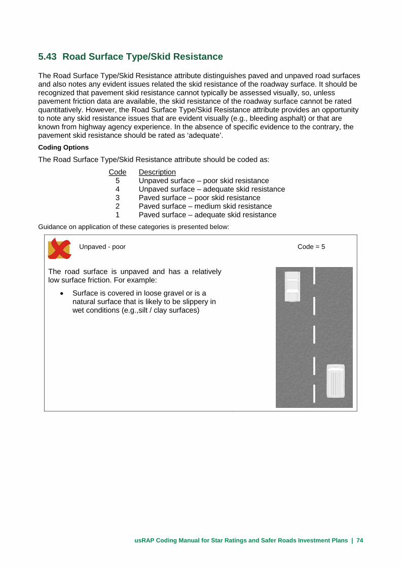
usRAP Coding Manual for Star Ratings and Safer Roads Investment Plans | 74
5.43 Road Surface Type/Skid Resistance
The Road Surface Type/Skid Resistance attribute distinguishes paved and unpaved road surfaces and also notes any evident issues related the skid resistance of the roadway surface. It should be recognized that pavement skid resistance cannot typically be assessed visually, so, unless pavement friction data are available, the skid resistance of the roadway surface cannot be rated quantitatively. However, the Road Surface Type/Skid Resistance attribute provides an opportunity to note any skid resistance issues that are evident visually (e.g., bleeding asphalt) or that are known from highway agency experience. In the absence of specific evidence to the contrary, the pavement skid resistance should be rated as ‘adequate’. Coding Options
The Road Surface Type/Skid Resistance attribute should be coded as:
Code Description 5 Unpaved surface – poor skid resistance 4 Unpaved surface – adequate skid resistance 3 Paved surface – poor skid resistance 2 Paved surface – medium skid resistance 1 Paved surface – adequate skid resistance
Guidance on application of these categories is presented below:
Unpaved - poor Code = 5
The road surface is unpaved and has a relatively low surface friction. For example:
• Surface is covered in loose gravel or is a natural surface that is likely to be slippery in wet conditions (e.g.,silt / clay surfaces)
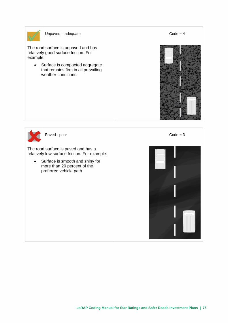
usRAP Coding Manual for Star Ratings and Safer Roads Investment Plans | 75
Unpaved – adequate Code = 4
The road surface is unpaved and has relatively good surface friction. For example:
• Surface is compacted aggregate that remains firm in all prevailing weather conditions
Paved - poor Code = 3
The road surface is paved and has a relatively low surface friction. For example:
• Surface is smooth and shiny for more than 20 percent of the preferred vehicle path

usRAP Coding Manual for Star Ratings and Safer Roads Investment Plans | 76
Paved - medium Code = 2
The road surface is paved and has medium surface friction. For example:
• Surface is smooth and shiny for up to 20 percent of the preferred vehicle path
Paved - adequate Code = 1
The road surface is paved and has adequate surface friction. There are no visible smooth and shiny sections and no indications of inadequate surface friction.

usRAP Coding Manual for Star Ratings and Safer Roads Investment Plans | 77
5.44 Delineation
The Delineation attribute represents the quality of traffic control devices present to guide drivers, and help drivers to remain within their chosen lane and to be aware to the road cross section ahead.
The Delineation attribute is based on a combination of the following factors:
• Centerlines
• Lane lines
• Edgelines
• Guideposts / delineators
• Signing
In addition, advisory signs are needed to warn drivers of any sudden change in the road conditions e.g., lane narrowing.
Quality of delineation for curves, intersections, and pedestrian crossings are recorded under other attributes (see Sections 5.35, 5.40, and 5.47) and should not be considered in coding the Delineation attribute. If poor delineation for curves, intersections, or pedestrian crossings is present, the coding for the Delineation attribute should remain the same as for the previous 300-ft (100-m) road segments that contain the feature in question.
If a road segment has no pavement markings, the Delineation attribute should be coded as poor. If pavement markings are present, the condition and quality of those pavement markings should be considered in determining the Delineation attribute.
The Delineation attribute should generally reflect the condition and quality of pavement marking for the majority of locations over extended sections of road because pavement marking projects generally address substantial lengths of road. It is not appropriate to change the code for the Delineation attribute for every 300-ft (100-m) road segment.
This attribute involves coding the quality of delineation under daylight conditions only, as information on night visibility cannot be obtained from a daytime photograph.
Coding Options
Poor Code = 2
Warning signs, or centerline, lane line, and edgeline markings are absent or in poor condition over long lengths

usRAP Coding Manual for Star Ratings and Safer Roads Investment Plans | 78
Adequate Code = 1
Warning signs and centerline, lane line, and edgeline markings are generally present and visible

usRAP Coding Manual for Star Ratings and Safer Roads Investment Plans | 79
5.45 Street Lighting
The Street Lighting attribute indicates whether street lighting is present on the roadway segment. Street lighting should be indicated as present if:
• Street lighting is present continuously along the roadway in question, or
• Street lighting is present at a specific feature within the 300 ft (100-m) roadway segment, such as an intersection or pedestrian crossing
To be coded as present, street lighting should be sufficient to make pedestrians and bicyclists visible to approaching drivers.
Coding Options
Not present Code = 1
Street lighting sufficient to illuminate pedestrians and bicyclists is not present.
Present Code = 2
Street lighting sufficient to illuminate pedestrians and bicyclists is present.

usRAP Coding Manual for Star Ratings and Safer Roads Investment Plans | 80
5.46 Pedestrian Crossing Facilities—Inspected Road
The Pedestrian Crossing Facilities attribute documents the presence of a purpose-built pedestrian crossing facility for crossing the road being inspected (i.e., the major road, not a side road).
The most important use of this information will be to assess whether a crossing facility is present or absent and where a crossing facility it is likely to be needed (e.g., as indicated by pedestrian flow and/or land use activity on both sides of the road) and whether, if a facility is present, its design could be improved.
Pedestrian crossing facilities should be recorded regardless of whether they are at an intersection or a midblock location.
If a pedestrian crossing facility is located at an intersection, the crossing facility must be recorded in the same 300-ft (100-m) segment as the intersection so that they can be linked in the analysis.
If two pedestrian crossings are present at an intersection, only one is recorded.
Only pedestrian crossing facilities for pedestrians crossing the road being inspected are recorded. Pedestrian crossing facilities for pedestrians crossing side roads are addressed in Section 5.48.
Coding Options
Refuge only Code = 6
No crossing is marked but a purpose-built central refuge is provided for pedestrians
No facility Code = 7
No provision for pedestrians crossing
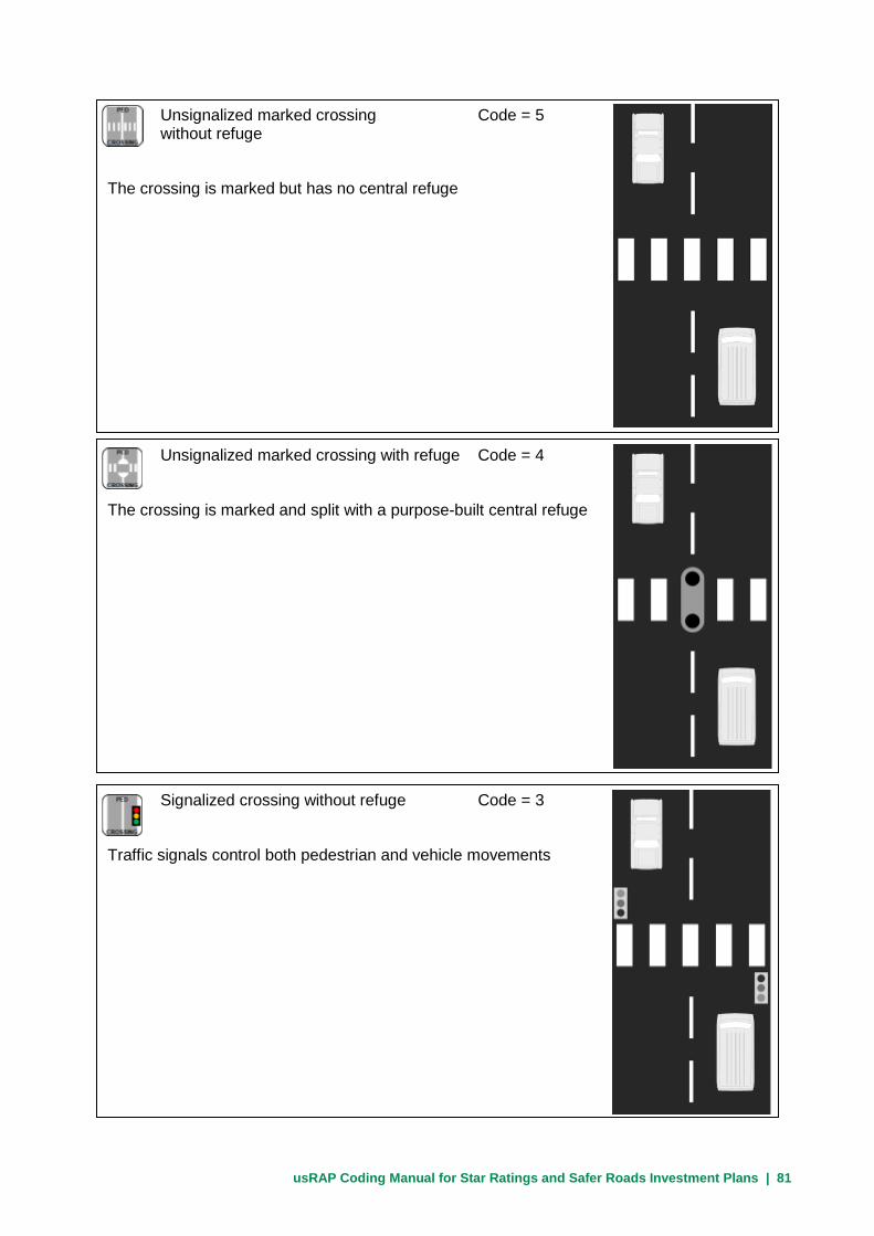
usRAP Coding Manual for Star Ratings and Safer Roads Investment Plans | 81
Unsignalized marked crossing Code = 5 without refuge
The crossing is marked but has no central refuge
Signalized crossing without refuge Code = 3
Traffic signals control both pedestrian and vehicle movements
Unsignalized marked crossing with refuge Code = 4
The crossing is marked and split with a purpose-built central refuge

usRAP Coding Manual for Star Ratings and Safer Roads Investment Plans | 82
Unsignalized raised marked crossing Code = 15 without refuge
Unsignalized raised marked crossing without a median refuge for pedestrians
Grade-separated facility Code = 1
The crossing is physically separated by grade (over or under the road) and does not bring pedestrians into conflict with traffic
Signalized crossing with refuge Code = 2
Traffic signals control both pedestrian and vehicle movements; the crossing is split with a purpose-built central refuge

usRAP Coding Manual for Star Ratings and Safer Roads Investment Plans | 83
5.47 Quality of Crossing
The Quality of Crossing attribute documents how well a pedestrian crossing can be seen by approaching drivers and whether there are advanced warning signs. This attribute applies to the pedestrian crossing on the inspected road that was coded for the same 300-ft (100-m) roadway segment (see Section 5.46).
Notes: Whenever a pedestrian crossing has been coded on the inspected road (see Section 5.46), the quality of that crossing must be recorded as well.
An assessment should be made as to whether some drivers may need to brake harshly because they become aware of the crossing too late or fail to see it completely.
The three primary factors to be considered in coding quality of crossing are: • Signing (at the crossing and for approaching drivers)
• Markings or a raised crossing
• Sight distance for approaching drivers
Where no pedestrian crossing is present (Code = 7 for pedestrian crossing facility on the inspected road in Section 5.46), the quality of crossing should always be coded as not applicable (Code = 3).
Coding Options
Poor Code = 2
The signing, marking, and sight distance are such that rapid or unexpected speed adjustments may be needed by approaching drivers to avoid risk to pedestrians using the crossing

usRAP Coding Manual for Star Ratings and Safer Roads Investment Plans | 84
5.48 Pedestrian Crossing Facilities—Side Road
The Pedestrian Crossing Facilities—Side Road attribute indicates the type of pedestrian crossing facility present on any side road that may be present within a 300-ft (100-m) roadway segment. Pedestrian crossing facilities on a side road must be coded within the same 300-ft (100-m) roadway segment as the Intersection Type code (see Section 5.32) for the intersection that contains the side-road approach in question. The Pedestrian Crossing Facilities—Side Road attribute is coded in the same manner whether pedestrian crossings are present on one or more than one side-road approach within a given 300-ft (100-m) roadway segment. The code for no facility (Code = 7) is used for roadway segments where no intersection is present and for segments where an intersection is present but there are no pedestrian crossing facilities on the side roads.
Coding Options The codes used for this attribute are same as those used for Pedestrian Crossing Facilities—Inspected Road (see Section 5.46), except that the codes apply to pedestrian crossing facilities on the side road.
Adequate Code = 1
Signing, marking, and sight distance enable approaching drivers to be aware in good time of the presence of the pedestrian crossing
Not applicable Code = 3
No pedestrian crossing is present on the inspected road

usRAP Coding Manual for Star Ratings and Safer Roads Investment Plans | 85
5.49 Pedestrian Fencing
The Pedestrian Fencing attribute indicates the presence or absence of fencing sufficient to keep pedestrians from entering or crossing the road except at purpose-built pedestrian crossing facilities
Coding Options
Not present Code = 1
There is no pedestrian fencing present or the fencing present is not sufficient to stop pedestrian crossing flow
Present Code = 2
Fencing is present that is sufficient to stop pedestrian crossing flow

usRAP Coding Manual for Star Ratings and Safer Roads Investment Plans | 86
5.50 Speed Management/Traffic Calming
The Speed Management/Traffic Calming attribute records the presence of any treatment that reduces operating speed to at least 5 mph less than the speed limit. Excample of speed management/traffic calming treatments include:
• Gateways
• Curb bulb outs
• Speed tables
• Speed bumps
Coding Options
Not present Code = 2
No speed management/traffic calming treatment is present to reduce vehicle operating speeds
Present Code = 1
A speed management/traffic calming treatment is present to reduce vehicle operating speeds to at least 5 mph less than the speed limit

usRAP Coding Manual for Star Ratings and Safer Roads Investment Plans | 87
5.51 Vehicle Parking
The Vehicle Parking attribute represents whether vehicles are parked on both sides of the road, one side of the road, or neither side of the road. This attribute does not address whether parking is legal or illegal, but rather addresses whether vehicles are actually parked. Parking is technically legal at many locations where vehicles seldom or never park, so the key issue is whether parked vehicles are actually observed. If there are parking spaces or a parking lane marked on the pavement on one or both sides of the road, that should be treated as evidence that vehicles park there even if no parked vehicles are observed in the video image or in the field.
Coding Options
The Vehicle Parking attribute is coded as follows:
Code Description 3 Vehicles park on both sides of the roadway 2 Vehicles park on only one side of the roadway 1 Vehicles are not parked along the roadway
Note: Code 3 should not be used on divided roads unless vehicles park in the highway median.

usRAP Coding Manual for Star Ratings and Safer Roads Investment Plans | 88
5.52 Sidewalk—Left Side
The Sidewalk—Left Side attribute documents the provision of a purpose-built sidewalk or informal path on the left side of the roadway. The sidewalk provision coding is based on the sidewalk’s separation distance from the outside through travel lane and the presence or absence of a traffic barrier between the motor vehicle traffic and pedestrians. The separation distance can be defined as the distance from the outside edge of the closest through travel lane to the nearest edge of the pedestrian sidewalk.
Provision for pedestrian crossing movements is not considered as part of this attribute.
A physical barrier can effectively remove the risk of a pedestrian being struck by an errant vehicle but, to be effective, the barrier must be sufficient to restrain a vehicle traveling at the posted speed limit from entering the pedestrian facility.
Curbs, while discouraging drivers from intentionally passing over them, do little to prevent errant vehicles from entering the sidewalk, unless specifically designed to do so; thus, curbs are not to be considered a physical barrier.
Categories are provided to code footpaths created by frequent pedestrian use and unpaved shoulders (where no paved shoulder is present) as informal paths. Unpaved shoulders (where no paved shoulder is present) should always be coded as ‘informal path separation 0 to 3 ft’. Do not code a paved shoulder as a sidewalk.
Shared-use paths parallel to the road should be coded both as sidewalks and as bicycle facilities (see Section 5.37).
For divided roads, code this left-side attribute as ‘None’.
Coding Options
None Code = 5
No discernible sidewalk is provided

usRAP Coding Manual for Star Ratings and Safer Roads Investment Plans | 89
Sidewalk adjacent to traffic; 0 to 3 ft Code = 4 separation from traffic with no barrier present
Sidewalk separated from travel lane by less than 3 ft, including paved shoulder, with no barrier provided between the traveled way and the sidewalk
0-3 ft
3 to 10 ft separation from Code = 3 traffic with no barrier present
Sidewalk separated from travel lane by 3 to 10 ft with no barrier provided between the traveled way and the sidewalk
3-10 ft
Greater than 10 ft separation from traffic Code = 2 with no barrier present
Sidewalk separated from travel lane by at least 10 ft with no barrier provided between the traveled way and the sidewalk
>10 ft

usRAP Coding Manual for Star Ratings and Safer Roads Investment Plans | 90
Informal path; 0 to 3 ft separation Code = 7 from traffic with no barrier present
Observation or evidence of pedestrian flow along the road using an informal path separated from the road by 0 to 3 ft; includes locations with unpaved shoulders
Informal path; more than 3 ft separation Code = 6 from traffic with no barrier present
Observation or evidence of pedestrian flow along the road using an informal path separated from the road by more than 3 ft
Physical barrier Code = 1
Sidewalk separated from travel lane by a physical barrier sufficient to restrain a vehicle traveling at the posted speed limit from entering the pedestrian facility

usRAP Coding Manual for Star Ratings and Safer Roads Investment Plans | 91
5.53 Sidewalk—Right Side
The Sidewalk—Right Side attribute documents the provision of a purpose-built sidewalk or informal path on the right side of the roadway.
The sidewalk provision coding is based on the sidewalk’s separation distance from the outside through travel lane and the presence or absence of a traffic barrier between the motor vehicle traffic and pedestrians. The separation distance can be defined as the distance from the outside edge of the closest through travel lane to the nearest edge of the pedestrian sidewalk.
Provision for pedestrian crossing movements is not considered as part of this attribute.
A physical barrier can effectively remove the risk of a pedestrian being struck by an errant vehicle but, to be effective, the physical barrier must be sufficient to restrain a vehicle traveling at the posted speed limit from entering the pedestrian facility.
Curbs, while discouraging drivers from intentionally passing over them, do little to prevent errant vehicles from entering the sidewalk, unless specifically designed to do so; thus, curbs are not to be considered a physical barrier.
Categories are provided to code footpaths created by frequent pedestrian use and unpaved shoulders (where no paved shoulder is present) as informal paths. Unpaved shoulders (where no paved shoulder is present) should always be coded as informal path separation ) to 3 ft. Do not code a paved shoulder as a sidewalk.
Shared-use paths parallel to the road should be coded both as sidewalks and as bicycle facilities (see Section 5.37).
Coding Options
None Code = 5
No discernible sidewalk is provided

usRAP Coding Manual for Star Ratings and Safer Roads Investment Plans | 92
Sidewalk adjacent to traffic; 0 to 3 ft Code = 4 separation from traffic with no barrier present
Sidewalk separated from the traveled way by less than 3 ft, including paved shoulder, with no barrier provided between the traveled way and the sidewalk
0-3 ft
3 to 10 ft separation from traffic Code = 3 with no barrier present
Sidewalk separated from travel lane by 3 to 10 ft with no barrier provided between the traveled way and the sidewalk
3-10 ft
Greater than 10 ft separation from traffic Code = 2 with no barrier present
Sidewalk separated from travel lane by at least 10 ft with no barrier provided between the traveled way and the sidewalk
> 10 ft

usRAP Coding Manual for Star Ratings and Safer Roads Investment Plans | 93
Informal path; 0 to 3 ft separation Code = 7
from traffic with no barrier present
Observation or evidence of pedestrian flow along the road using an informal path separated from the road by 0 to 3 ft; includes locations with unpaved shoulders
Informal path; more than 3 ft separation Code = 6
from traffic with no barrier present
Observation or evidence of pedestrian flow along the road using an informal path separated from the road by more than 3 ft
Physical barrier Code = 1
Sidewalk separated from traveled way by a physical barrier sufficient to restrain a vehicle traveling at the posted speed limit from entering the pedestrian facility
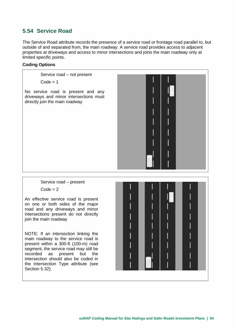
usRAP Coding Manual for Star Ratings and Safer Roads Investment Plans | 94
5.54 Service Road
The Service Road attribute records the presence of a service road or frontage road parallel to, but outside of and separated from, the main roadway. A service road provides access to adjacent properties at driveways and access to minor intersections and joins the main roadway only at limited specific points.
Coding Options
Service road – not present
Code = 1
No service road is present and any driveways and minor intersections must directly join the main roadway
Service road – present
Code = 2
An effective service road is present on one or both sides of the major road and any driveways and minor intersections present do not directly join the main roadway
NOTE: If an intersection linking the main roadway to the service road is present within a 300-ft (100-m) road segment, the service road may still be recorded as present but the intersection should also be coded in the Intersection Type attribute (see Section 5.32).

usRAP Coding Manual for Star Ratings and Safer Roads Investment Plans | 95
5.55 Motorcycle Facilities
The Motorcycle Facilities attribute documents the presence of purpose-built facilities for motorcycles or other motorized two-wheel vehicles.
This attribute includes segregated motorcycle paths completely separated from other traffic by barriers, as well as dedicated lanes within the roadway but to one side of the other motor vehicle traffic.
For the facility to get a code of ‘segregated motorcycle path with barrier’, there must be a physical barrier sufficient enough to fully restrict motor vehicles traveling at the posted speed limit from entering the motorcycle path.
This attribute is included only for international use. There are no known motorcycle facilities in the U.S. at present, so Code 6 should be used in all cases.
Coding Options
None Code = 6
No specific facilities provided for motorcycles or other motorized two-wheel vehicles
Dedicated motorcycle lane on roadway Code = 5
Dedicated motorcycle lane separated from othe traffic by a lane marking

usRAP Coding Manual for Star Ratings and Safer Roads Investment Plans | 96
Separated two-way motorcycle Code = 4 path with no barrier
Motorcycle path separated from traffic by at least 3 ft (by either a curb or an equivalent wide, raised surface)
Separated one-way motorcycle Code = 2 path with no barrier
Motorcycle path separated from traffic by at least 3 ft (by either a curb or an equivalent wide, raised surface)
Separated one-way motorcycle Code = 1 path with a barrier
Segregated motorcycle path separated from the roadway by a physical barrier or located at least 30 ft from the road

usRAP Coding Manual for Star Ratings and Safer Roads Investment Plans | 97
Separated two-way motorcycle Code = 3 path with barrier
Segregated motorcycle path separated from other traffic by a physical barrier or located at least 30 ft from the road

usRAP Coding Manual for Star Ratings and Safer Roads Investment Plans | 98
5.56 Bicycle Facilities
The Bicycle Facilities attribute documents purpose-built facilities for bicyclists.
To increase the safety for bicyclists, dedicated paths or lanes are added to some major roads and some expressways. These may include segregated bicycle paths completely separated from motor vehicle traffic by barriers or distance, as well as dedicated lanes within the roadway but to one side of the motor vehicle traffic. An extra-wide outside or curb lane can also serve as a combined bicycle and motor vehicle facility.
A physical barrier can effectively remove the risk of a bicycle being struck by an errant motor vehicle but, to be effective, the barrier must be sufficient to restrain a vehicle traveling at the posted speed limit from entering the bicycle facility.
With the exception of extra-wide outside or curb lanes, all facilities coded for this attribute are intended exclusively for bicycles (or bicycles and pedestrians).
Some bicycle facilities may be provided alongside sidewalks or as shared-use paths; shared-use paths parallel to the roadway should be coded both as bicycle facilities and as sidewalks (see Sections 5.52 and 5.53).
Use the same codes whether bicycle facility is on one side or both sides for undivided roads.
Coding Options
None Code = 4
No specific provisions for bicycles
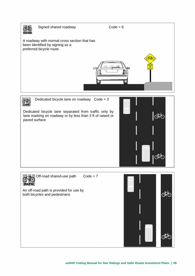
usRAP Coding Manual for Star Ratings and Safer Roads Investment Plans | 99
Signed shared roadway Code = 6
A roadway with normal cross section that has been identified by signing as a preferred bicycle route.
Off-road shared-use path Code = 7
An off-road path is provided for use by both bicycles and pedestrians
Dedicated bicycle lane on roadway Code = 3
Dedicated bicycle lane separated from traffic only by lane marking on roadway or by less than 3 ft of raised or paved surface

usRAP Coding Manual for Star Ratings and Safer Roads Investment Plans | 100
Extra wide curb lane
The outside or curb lane of the roadway in at least one direction of travel and at least 14 ft in width
Off-road bicycle path Code = 2
Bicycle path separated from motor vehicle traffic by more than 3 ft of raised or paved surface
Off-road bicycle path with barrier Code = 1
Segregated bicycle path separated from motor vehicle traffic by a physical barrier or located at least 30 ft from the road
The physical barrier must be sufficient to restrain a vehicle traveling at the posted speed limit from entering the bicycle facility.

usRAP Coding Manual for Star Ratings and Safer Roads Investment Plans | 101
5.57 Roadworks (Work Zones)
The Roadworks attribute documents where road construction or maintenance is in progress or work zones are present.
The purpose of the Roadworks attribute is to indicate that the road design after the project cannot necessarily be determined from the inspection data.
Coding Options
Minor roadworks in progress Code = 2
Record the presence of minor roadworks or work zones, such as short-term road maintenance or utility work
Major roadworks in progress Code = 3
Record the presence of major roadworks or work zones
Minor roadworks, such as short-term road maintenance or utility work, should be recorded with Code 2 (see below)

usRAP Coding Manual for Star Ratings and Safer Roads Investment Plans | 102
No roadworks Code = 1 No major roadworks are in progress

usRAP Coding Manual for Star Ratings and Safer Roads Investment Plans | 103
5.58 Sight Distance
The Sight Distance attribute documents the ability of the driver to see pedestrians and bicyclists in the roadway, to see pedestrians and bicyclists about to cross the road ahead, or to see vehicles at an intersection. Either the horizontal and vertical alignment of the road or sight obstructions such as roadside objects and vegetation may reduce sight distance.
NOTE: This attribute is used specifically to document locations with extremely limited sight distance (less than 300 ft). Such locations are quite rare in the U.S. road system. Therefore, this code should be used sparingly.
Code Options The coding option for sight distance are:
Code Description 2 Poor (major sight distance restriction along the road) 1 Adequate (no major sight distance restriction along
the road)

usRAP Coding Manual for Star Ratings and Safer Roads Investment Plans | 104
5.59 School Zone Warning
The School Zone Warning attribute addresses whether a school is present and whether specific traffic control devices are used to call the attention of motorists to the presence of the school and, therefore, to the possibility of students walking to and from school.
Coding Options
The codes used for this attribute are:
Code Description 3 School present, but no school zone warning devices 2 School zone static signs or road markings 1 School zone flashing beacons 4 Not applicable (no school present at this location)
5.60 School Zone Crossing Guard
The School Zone Crossing Guard attribute addresses whether a school is present and whether a school zone crossing guard is used within the school zone. If a school is present, but the use of a school zone crossing guard is unknown, use Code 2. Coding Options
The codes used for this attribute are:
Code Description 2 School present, but school zone crossing guard not present 1 School zone crossing guard present at school start and finish times 3 Not applicable (no school present at this location)

usRAP Coding Manual for Star Ratings and Safer Roads Investment Plans | 105
6 Pre-Processing usRAP Input Data After Coding The following usRAP attributes may be coded in preliminary form by coding personnel and may then require updating as a part of the pre-processing state:
Section Description 5.03 Road Survey date 5.04 Image reference 5.11 Landmark 5.12 Comments 5.21 Speed limit 5.22 Motorcycle speed limit 5.23 Truck speed liimit
The following usRAP attributes needed for the upload file are not generally coded from video data or in the field. Rather, these attributes should be added in the pre-processing stage. Procedures for adding these data to the upload file are presented in the Guide for Producing usRAP Star Ratings and Safer Roads Investment Plans:
• Differential speed limits
• Vehicle flow (AADT)
• Motorcycle percentage in traffic flow
• Pedestrian peak hour flow across the road
• Pedestrian peak hour flow along the road-left side
• Pedestrian peak hour flow along the road-right side
• Bicycle peak hourly flow
• 85th percentile operating speed
• Mean operating speed
• Roads that cars can read
• Car star rating policy target
• Motorcycle star rating policy target
• Pedestrian star rating policy target
• Bicycle star rating policy target
• Annual fatality growth multiplier

usRAP Coding Manual for Star Ratings and Safer Roads Investment Plans | 106

usRAP Coding Manual for Star Ratings and Safer Roads Investment Plans | 107
Appendix A – Specification for Coded Data File
This appendix presents the specification for the data file to be created by usRAP coders for subsequent use
as input data for ViDA Version 3.0. usRAP Team Leaders have flexibility in modifying the specification for
this file for particular studies. See Appendix B for the upload file specification to be created from the coded
data in the preprocessing stage.
Suggested column letter in
coded data
Section number in this manual
Attribute Category Code
A 5.1 Coder name Text
B 5.2 Coding date Text
C 5.3 Road survey date (optional) Text
D 5.4 Image reference number (optional) Text
E 5.5 Road name Text
F 5.6 Section name/number (optional) Text
G 5.7 Distance Decimal number
H 5.8 Length (optional) Decimal number 0.1
I 5.9 Latitude Decimal number
J 5.9 Longitude Decimal number (negative value in
the U.S.)
K 5.10 Landmark (optional) Text
L 5.11 Comments (optional) Text
M 5.12 Carriageway/roadway type Undivided 1
A - Divided 2
B - Divided 3
N 5.13 Upgrade cost Low 1
Medium 2
High 3
O 5.14 Observed motorcycle flow (optional) No motorcycles observed 1
1 motorcycle observed 2
2 to 3 motorcycles observed 3
4 to 5 motorcycles observed 4
6 to 7 motorcycles observed 5
8+ motorcycles observed 6

usRAP Coding Manual for Star Ratings and Safer Roads Investment Plans | 108
Suggested column letter in
coded data
Section number in this manual
Attribute Category Code
P 5.15 Observed bicycle flow No bicycles observed and no
evidence of bicycle travel
1
1 bicycle observed or evidence of
bicycle travel
2
2 to 3 bicycles observed 3
4 to 5 bicycles observed 4
6 to 7 bicycles observed 5
8+ bicycles observed 6
Q 5.16 Observed pedestrian flow across the road No pedestrians observed and no
evidence of pedestrian travel
1
1 pedestrian observed or evidence
of pedestrian travel
2
2 to 3 pedestrians observed 3
4 to 5 pedestrians observed 4
6 to 7 pedestrians observed 5
8+ pedestrians observed 6
R 5.17 Observed pedestrian flow along the road –
left side
No pedestrians observed and no
evidence of pedestrian travel
1
1 pedestrian observed or evidence
of pedestrian travel
2
2 to 3 pedestrians observed 3
4 to 5 pedestrians observed 4
6 to 7 pedestrians observed 5
8+ pedestrians observed 6
S 5.18 Observed pedestrian flow along the road –
right side
No pedestrians observed and no
evidence of pedestrian travel
1
1 pedestrian observed or evidence
of pedestrian travel
2
2 to 3 pedestrians observed 3
4 to 5 pedestrians observed 4
6 to 7 pedestrians observed 5
8+ pedestrians observed 6
T 5.19 Land use – left side Undeveloped areas 1
Farming and agricultural 2
Residential 3

usRAP Coding Manual for Star Ratings and Safer Roads Investment Plans | 109
Suggested column letter in
coded data
Section number in this manual
Attribute Category Code
Commercial 4
Not recorded 5
Educational 6
Industrial and manufacturing 7
U 5.19 Land use – right side Undeveloped areas 1
Farming and agricultural 2
Residential 3
Commercial 4
Not recorded 5
Educational 6
Industrial and manufacturing 7
V 5.20 Area type Rural 1
Urban 2
W 5.21 Speed limit Numeric
(code the numeric value of the speed limit
in mph; i.e., if the speed limit is 55 mph,
then code 55. Do not include the mph
abbreviation or any other text.
X 5.22 Motorcycle speed limit Numeric or blank
(Motorcycle speed limits are not used in the
United States. This attribute should be
omitted or left blank in U.S. studies)
Y 5.23 Truck speed limit Numeric or blank
(Code the numeric value of any truck speed
limit that differs from the general speed
limit. If the speed limit for trucks is the
same as the general speed limit, leave this
attribute blank)
Z 5.24 Median type Traffic barrier -- metal 1
Traffic barrier -- concrete 2
Physical median width > 65 ft 3
Physical median width 30-65 ft 4
Physical median width 15-30 ft 5
Physical median width 3-15 ft 6
Physical median width up to 3 ft 7

usRAP Coding Manual for Star Ratings and Safer Roads Investment Plans | 110
Suggested column letter in
coded data
Section number in this manual
Attribute Category Code
Continuous central turning lane 8
Flexible posts 9
Central hatching (> 3 ft) 10
Centerline only 11
Motorcycle friendly barrier 12
Not applicable (e.g., one-way road) 13
Wide centreline (1 to 3 ft) 14
Traffic barrier -- cable 15
AA 5.25 Centerline rumble strips Not present 1
Present 2
AB 5.28 Roadside severity distance – left side 0 to < 3 ft 1
3 to <15 ft 2
15 to <30 ft 3
≥ 30 ft 4
AC 5.29 Roadside severity object – left side Traffic barrier -- metal 1
Traffic barrier -- concrete 2
Traffic barrier – motorcycle friendly 3
Traffic barrier -- cable 4
Aggressive vertical face 5
Upwards slope (15 to 75⁰) 6
Upwards slope (≥75⁰) 7
Deep drainage ditch 8
Downwards slope (≥15⁰) 9
Cliff 10
Tree > 4 in 11
Non-frangible sign/post/pole > 4 in 12
Rigid structure/bridge or building 13
Semi-rigid structure or building 14
Unprotected traffic barrier end 15
Large boulders > 8 in high 16
No object 17
AD 5.26 Roadside severity distance – right side 0 to < 3 ft 1
3 to <15 ft 2
15 to <30 ft 3
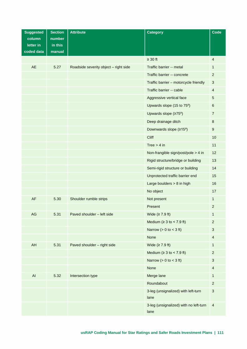
usRAP Coding Manual for Star Ratings and Safer Roads Investment Plans | 111
Suggested column letter in
coded data
Section number in this manual
Attribute Category Code
≥ 30 ft 4
AE 5.27 Roadside severity object – right side Traffic barrier -- metal 1
Traffic barrier -- concrete 2
Traffic barrier – motorcycle friendly 3
Traffic barrier -- cable 4
Aggressive vertical face 5
Upwards slope (15 to 75⁰) 6
Upwards slope (≥75⁰) 7
Deep drainage ditch 8
Downwards slope (≥15⁰) 9
Cliff 10
Tree > 4 in 11
Non-frangible sign/post/pole > 4 in 12
Rigid structure/bridge or building 13
Semi-rigid structure or building 14
Unprotected traffic barrier end 15
Large boulders > 8 in high 16
No object 17
AF 5.30 Shoulder rumble strips Not present 1
Present 2
AG 5.31 Paved shoulder – left side Wide (≥ 7.9 ft) 1
Medium (≥ 3 to < 7.9 ft) 2
Narrow (> 0 to < 3 ft) 3
None 4
AH 5.31 Paved shoulder – right side Wide (≥ 7.9 ft) 1
Medium (≥ 3 to < 7.9 ft) 2
Narrow (> 0 to < 3 ft) 3
None 4
AI 5.32 Intersection type Merge lane 1
Roundabout 2
3-leg (unsignalized) with left-turn
lane
3
3-leg (unsignalized) with no left-turn
lane
4

usRAP Coding Manual for Star Ratings and Safer Roads Investment Plans | 112
Suggested column letter in
coded data
Section number in this manual
Attribute Category Code
3-leg (signalized) with left-turn lane 5
3-leg (signalized) with no left-turn
lane
6
4-leg (unsignalized) with left-turn
lane
7
4-leg (unsignalized) with no left-turn
lane
8
4-leg (signalized) with left-turn lane 9
4-leg (signalized) with no left-turn
lane
10
None 12
Railway crossing - passive (signs
only)
13
Railway crossing - active (flashing
lights / automatic gates)
14
Median crossing point – no turn
lanes
15
Median crossing point – with turn
lanes
16
AJ 5.33 Intersection channelization Not present 1
Present 2
AK 5.34 Intersecting road volume ≥ 15,000 veh/day 1
10,000 to 15,000 veh/day 2
5,000 to 10,000 veh/day 3
1,000 to 5,000 veh/day 4
100 to 1,000 veh/day 5
< 100 veh/day 6
Not recorded / unknown 7
AL 5.35 Intersection quality Adequate 1
Poor 2
Not applicable 3
AM 5.36 Property access points Commercial access ≥ 1 1
Residential access ≥ 3 2
Residential access < 3 3
None 4

usRAP Coding Manual for Star Ratings and Safer Roads Investment Plans | 113
Suggested column letter in
coded data
Section number in this manual
Attribute Category Code
AN 5.37 Number of through traffic lanes One 1
Two 2
Three 3
Four or more 4
Two and one 5
Three and two 6
AO 5.38 Lane widths for through traffic lanes Wide ≥ 10.6 ft 1
Medium ≥ 9 to < 10.6 ft 2
Narrow < 9 ft 3
AP 5.39 Curvature Straight or gently curving 1
Moderate curvature 2
Sharp curvature 3
Very sharp curvature 4
AR 5.40 Quality of curve Adequate 1
Poor 2
Not applicable 3
AS 5.41 Grade ≥ 10% 1
≥ 7.5% to <10% 4
0 to < 7.5% 5
AT 5.42 Road condition Good 1
Medium 2
Poor 3
AU 5.43 Road surface type/skid resistance Paved – adequate skid resistance 1
Paved – medium surface friction 2
Paved – poor surface friction 3
Unpaved – adequate surface friction 4
Unpaved – poor surface friction 5
AV 5.44 Delineation Adequate 1
Poor 2
AW 5.45 Street lighting Not present 1
Present 2
AX 5.46 Pedestrian crossing facility – inspected
road
Grade separated facility 1
Signalized with refuge 2

usRAP Coding Manual for Star Ratings and Safer Roads Investment Plans | 114
Suggested column letter in
coded data
Section number in this manual
Attribute Category Code
Signalized without refuge 3
Unsignalized marked crossing with
refuge
4
Unsignalized marked crossing
without refuge
5
Refuge only 6
No facility 7
Unsignalized raised marked
crossing with refuge
14
Unsignalized raised marked
crossing without refuge
15
Raised unmarked crossing with
refuge
16
Raised unmarked crossing without
refuge
17
AY 5.47 Pedestrian crossing quality Adequate 1
Poor 2
Not applicable 3
AZ 5.48 Pedestrian crossing facility – side road Grade separated facility 1
Signalized with refuge 2
Signalized without refuge 3
Unsignalized marked crossing with
refuge
4
Unsignalized marked crossing
without refuge
5
Refuge only 6
No facility 7
Unsignalized raised marked
crossing with refuge
14
Unsignalized raised marked
crossing without refuge
15
Raised unmarked crossing with
refuge
16
Raised unmarked crossing without
refuge
17
BA 5.49 Pedestrian fencing Not present 1

usRAP Coding Manual for Star Ratings and Safer Roads Investment Plans | 115
Suggested column letter in
coded data
Section number in this manual
Attribute Category Code
Present 2
BB 5.50 Speed management/traffic calming Not present 1
Present 2
BC 5.51 Vehicle parking None 1
One side of the roadway 2
Both sides of the roadway 3
BD 5.52 Sidewalk – left side Physical barrier between road and
sidewalk
1
Separation > 10 ft between road
and sidewalk with no barrier present
2
Separation > 3 ft between road and
sidewalk with no barrier present
3
Sidewalk adjacent to traffic (within 3
ft)
4
No sidewalk present 5
Informal path with separation ≥ 3 ft
between road and traffic
6
Informal path with separation < 3 ft
between road and traffic
7
BE 5.53 Sidewalk provision - right Physical barrier between road and
sidewalk
1
Separation > 10 ft between road
and sidewalk with no barrier present
2
Separation 3 10 < 10 ft between
road and sidewalk with no barrier
present
3
Sidewalk adjacent to traffic (within 3
ft) with no barrier present
4
No sidewalk present 5
Informal path with separation ≥ 3 ft
between road and traffic
6
Informal path with separation < 3 ft
between road and traffic
7
BF 5.54 Service road Not present 1
Present 2
BG 5.55 Motorcycle facility Exclusive one-way motorcycle path 1
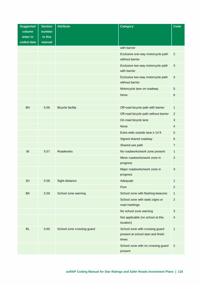
usRAP Coding Manual for Star Ratings and Safer Roads Investment Plans | 116
Suggested column letter in
coded data
Section number in this manual
Attribute Category Code
with barrier
Exclusive one-way motorcycle path
without barrier
2
Exclusive two-way motorcycle path
with barrier
3
Exclusive two-way motorcycle path
without barrier
4
Motorcycle lane on roadway 5
None 6
BH 5.56 Bicycle facility Off-road bicycle path with barrier 1
Off-road bicycle path without barrier 2
On-road bicycle lane 3
None 4
Extra wide outside lane ≥ 14 ft 5
Signed shared roadway 6
Shared-use path 7
BI 5.57 Roadworks No roadworks/work zone present 1
Minor roadworks/work zone in
progress
2
Major roadworks/work zone in
progress
3
BJ 5.58 Sight distance Adequate 1
Poor 2
BK 5.59 School zone warning School zone with flashing beacons 1
School zone with static signs or
road markings
2
No school zone warning 3
Not applicable (no school at this
location)
4
BL 5.60 School zone crossing guard School zone with crossing guard
present at school start and finish
times
1
School zone with no crossing guard
present
2

usRAP Coding Manual for Star Ratings and Safer Roads Investment Plans | 117
Suggested column letter in
coded data
Section number in this manual
Attribute Category Code
Not applicable (no school at this
location)
3

usRAP Coding Manual for Star Ratings and Safer Roads Investment Plans | 118

usRAP Coding Manual for Star Ratings and Safer Roads Investment Plans | 119
Appendix B - Input Data File Specification for Uploading to ViDA Software
This appendix presents the required format for uploading data to the ViDA Version 3.0 software. The data
coded in accordance with this manual (see Section 5 and Appendix A) must be converted to this format in
the preprocessing stage and data elements presented below, but not coded in Appendix A, must be added
before the data can be uploaded and processed. This format is a requirement for the ViDA software and
cannot be modified. A code must be provided for every attribute unless the word ‘optional’ is specified below.
Only ‘optional’ attributes can have blank values in the upload file.
Required column number/ letter in upload file
Attribute Category Code
1 A Coder name Text
2 B Coding date Text
3 C Road survey date Text
4 D Image reference number (optional) Text
5 E Road name Text
6 F Section name/number Text
7 G Distance Decimal number
8 H Length Decimal number 0.1
9 I Latitude Decimal number
10 J Longitude Decimal number (negative value in the U.S.)
11 K Landmark (optional) Text
12 L Comments (optional) Text
13 M Carriageway/roadway type Undivided 1
A - Divided 2
B - Divided 3
Motorcycle facility - Carriageway A 4
Motorcycle facility - Carriageway B 5
14 N Upgrade cost Low 1
Medium 2
High 3
15 O Observed motorcycle flow No motorcycles observed 1

usRAP Coding Manual for Star Ratings and Safer Roads Investment Plans | 120
Required column number/ letter in upload file
Attribute Category Code
1 motorcycle observed 2
2 to 3 motorcycles observed 3
4 to 5 motorcycles observed 4
6 to 7 motorcycles observed 5
8+ motorcycles observed 6
16 P Observed bicycle flow No bicycles observed and no evidence of
bicycle travel
1
1 bicycle observed or evidence of bicycle
travel
2
2 to 3 bicycles observed 3
4 to 5 bicycles observed 4
6 to 7 bicycles observed 5
8+ bicycles observed 6
17 Q Observed pedestrian flow across the road No pedestrians observed and no evidence of
pedestrian travel
1
1 pedestrian observed or evidence of
pedestrian travel
2
2 to 3 pedestrians observed 3
4 to 5 pedestrians observed 4
6 to 7 pedestrians observed 5
8+ pedestrians observed 6
18 R Observed pedestrian flow along the road –
left side
No pedestrians observed and no evidence of
pedestrian travel
1
1 pedestrian observed or evidence of
pedestrian travel
2
2 to 3 pedestrians observed 3
4 to 5 pedestrians observed 4
6 to 7 pedestrians observed 5
8+ pedestrians observed 6
19 S Observed pedestrian flow along the road –
right side
No pedestrians observed and no evidence of
pedestrian travel
1
1 pedestrian observed or evidence of
pedestrian travel
2

usRAP Coding Manual for Star Ratings and Safer Roads Investment Plans | 121
Required column number/ letter in upload file
Attribute Category Code
2 to 3 pedestrians observed 3
4 to 5 pedestrians observed 4
6 to 7 pedestrians observed 5
8+ pedestrians observed 6
20 T Land use – left side Undeveloped areas 1
Farming and agricultural 2
Residential 3
Commercial 4
Not recorded 5
Educational 6
Industrial and manufacturing 7
21 U Land use – right side Undeveloped areas 1
Farming and agricultural 2
Residential 3
Commercial 4
Not recorded 5
Educational 6
Industrial and manufacturing 7
22 V Area type Rural 1
Urban 2
23 W Speed limit ≥ 150 km/h 25
140 km/h 23
130 km/h 21
120 km/h 19
110 km/h 17
100 km/h 15
90 km/h 13
80 km/h 11
70 km/h 9
60 km/h 7
50 km/h 5
40 km/h 3

usRAP Coding Manual for Star Ratings and Safer Roads Investment Plans | 122
Required column number/ letter in upload file
Attribute Category Code
≤30 km/h 1
≥ 90 mph 45
85 mph 44
80 mph 43
75 mph 42
70 mph 41
65 mph 40
60 mph 39
55 mph 38
50 mph 37
45 mph 36
40 mph 37
35 mph 36
30 mph 35
25 mph 34
≤ 20 mph 33
24 X Motorcycle speed limit ≥ 150 km/h 25
140 km/h 23
130 km/h 21
120 km/h 19
110 km/h 17
100 km/h 15
90 km/h 13
80 km/h 11
70 km/h 9
60 km/h 7
50 km/h 5
40 km/h 3
≤30 km/h 1
≥ 90 mph 45
85 mph 44
80 mph 43
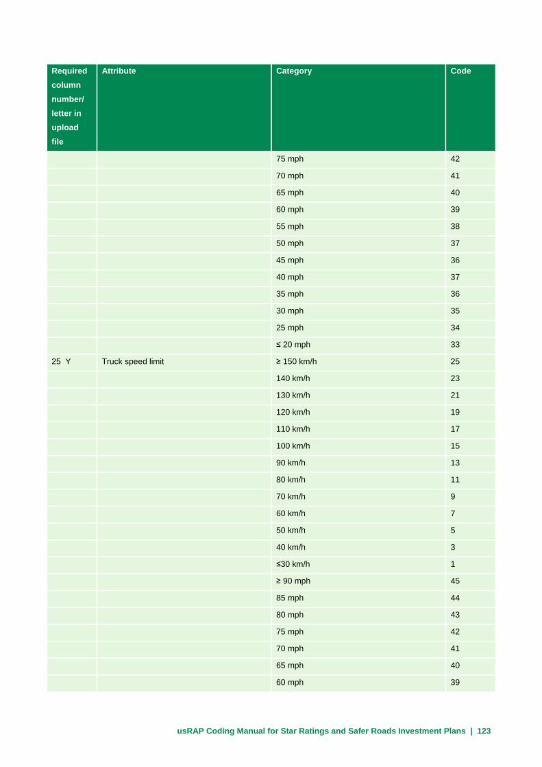
usRAP Coding Manual for Star Ratings and Safer Roads Investment Plans | 123
Required column number/ letter in upload file
Attribute Category Code
75 mph 42
70 mph 41
65 mph 40
60 mph 39
55 mph 38
50 mph 37
45 mph 36
40 mph 37
35 mph 36
30 mph 35
25 mph 34
≤ 20 mph 33
25 Y Truck speed limit ≥ 150 km/h 25
140 km/h 23
130 km/h 21
120 km/h 19
110 km/h 17
100 km/h 15
90 km/h 13
80 km/h 11
70 km/h 9
60 km/h 7
50 km/h 5
40 km/h 3
≤30 km/h 1
≥ 90 mph 45
85 mph 44
80 mph 43
75 mph 42
70 mph 41
65 mph 40
60 mph 39

usRAP Coding Manual for Star Ratings and Safer Roads Investment Plans | 124
Required column number/ letter in upload file
Attribute Category Code
55 mph 38
50 mph 37
45 mph 36
40 mph 37
35 mph 36
30 mph 35
25 mph 34
≤ 20 mph 33
26 Z Differential speeds Not present 1
Present 2
27 AA Median type Traffic barrier -- metal 1
Traffic barrier -- concrete 2
Physical median width > 65 ft 3
Physical median width 30-65 ft 4
Physical median width 15-30 ft 5
Physical median width 3-15 ft 6
Physical median width up to 3 ft 7
Continuous central turning lane 8
Flexible posts 9
Central hatching (> 3 ft) 10
Centerline only 11
Motorcycle friendly barrier 12
Not applicable (e.g., one-way road) 13
Wide centreline (1 to 3 ft) 14
Traffic barrier -- cable 15
28 AB Centerline rumble strips Not present 1
Present 2
29 AC Roadside severity distance – left side 0 to < 3 ft 1
3 to <15 ft 2
15 to <30 ft 3
≥ 30 ft 4
30 AD Roadside severity object – left side Traffic barrier -- metal 1

usRAP Coding Manual for Star Ratings and Safer Roads Investment Plans | 125
Required column number/ letter in upload file
Attribute Category Code
Traffic barrier -- concrete 2
Traffic barrier – motorcycle friendly 3
Traffic barrier -- cable 4
Aggressive vertical face 5
Upwards slope (15 to 75⁰) 6
Upwards slope (≥75⁰) 7
Deep drainage ditch 8
Downwards slope (≥15⁰) 9
Cliff 10
Tree > 4 in 11
Non-frangible sign/post/pole > 4 in 12
Rigid structure/bridge or building 13
Semi-rigid structure or building 14
Unprotected traffic barrier end 15
Large boulders > 8 in high 16
No object 17
31 AE Roadside severity distance – right side 0 to < 3 ft 1
3 to <15 ft 2
15 to <30 ft 3
≥ 30 ft 4
32 AF Roadside severity object – right side Traffic barrier -- metal 1
Traffic barrier -- concrete 2
Traffic barrier – motorcycle friendly 3
Traffic barrier -- cable 4
Aggressive vertical face 5
Upwards slope (15 to 75⁰) 6
Upwards slope (≥75⁰) 7
Deep drainage ditch 8
Downwards slope (≥15⁰) 9
Cliff 10
Tree > 4 in 11
Non-frangible sign/post/pole > 4 in 12

usRAP Coding Manual for Star Ratings and Safer Roads Investment Plans | 126
Required column number/ letter in upload file
Attribute Category Code
Rigid structure/bridge or building 13
Semi-rigid structure or building 14
Unprotected traffic barrier end 15
Large boulders > 8 in high 16
No object 17
33 AG Shoulder rumble strips Not present 1
Present 2
34 AH Paved shoulder – left side Wide (≥ 7.9 ft) 1
Medium (≥ 3 to < 7.9 ft) 2
Narrow (> 0 to < 3 ft) 3
None 4
35 AI Paved shoulder – right side Wide (≥ 7.9 ft) 1
Medium (≥ 3 to < 7.9 ft) 2
Narrow (> 0 to < 3 ft) 3
None 4
36 AJ Intersection type Merge lane 1
Roundabout 2
3-leg (unsignalized) with left-turn lane 3
3-leg (unsignalized) with no left-turn lane 4
3-leg (signalized) with left-turn lane 5
3-leg (signalized) with no left-turn lane 6
4-leg (unsignalized) with left-turn lane 7
4-leg (unsignalized) with no left-turn lane 8
4-leg (signalized) with left-turn lane 9
4-leg (signalized) with no left-turn lane 10
None 12
Railway crossing - passive (signs only) 13
Railway crossing - active (flashing lights /
automatic gates)
14
Median crossing point – no turn lanes 15
Median crossing point – with turn lanes 16
37 AK Intersection channelization Not present 1
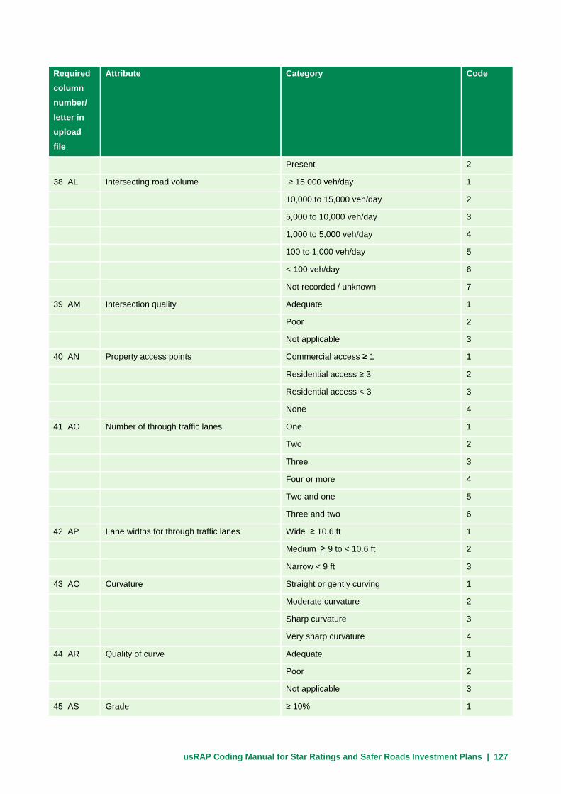
usRAP Coding Manual for Star Ratings and Safer Roads Investment Plans | 127
Required column number/ letter in upload file
Attribute Category Code
Present 2
38 AL Intersecting road volume ≥ 15,000 veh/day 1
10,000 to 15,000 veh/day 2
5,000 to 10,000 veh/day 3
1,000 to 5,000 veh/day 4
100 to 1,000 veh/day 5
< 100 veh/day 6
Not recorded / unknown 7
39 AM Intersection quality Adequate 1
Poor 2
Not applicable 3
40 AN Property access points Commercial access ≥ 1 1
Residential access ≥ 3 2
Residential access < 3 3
None 4
41 AO Number of through traffic lanes One 1
Two 2
Three 3
Four or more 4
Two and one 5
Three and two 6
42 AP Lane widths for through traffic lanes Wide ≥ 10.6 ft 1
Medium ≥ 9 to < 10.6 ft 2
Narrow < 9 ft 3
43 AQ Curvature Straight or gently curving 1
Moderate curvature 2
Sharp curvature 3
Very sharp curvature 4
44 AR Quality of curve Adequate 1
Poor 2
Not applicable 3
45 AS Grade ≥ 10% 1
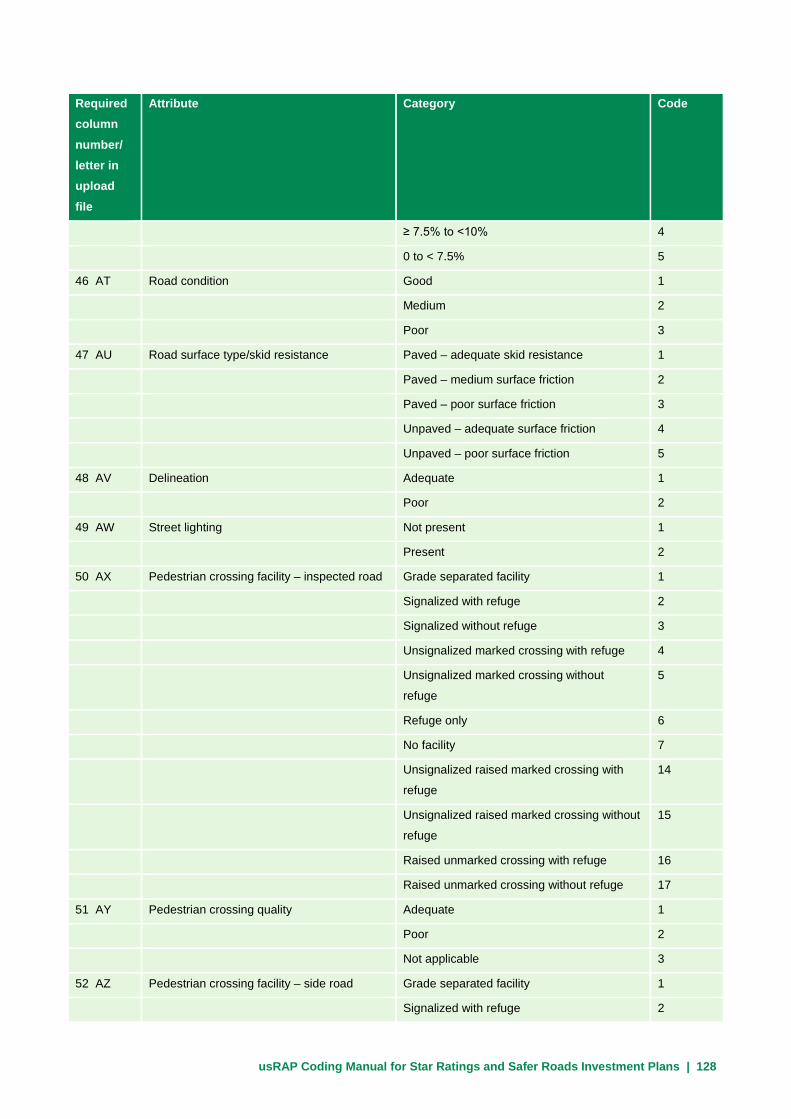
usRAP Coding Manual for Star Ratings and Safer Roads Investment Plans | 128
Required column number/ letter in upload file
Attribute Category Code
≥ 7.5% to <10% 4
0 to < 7.5% 5
46 AT Road condition Good 1
Medium 2
Poor 3
47 AU Road surface type/skid resistance Paved – adequate skid resistance 1
Paved – medium surface friction 2
Paved – poor surface friction 3
Unpaved – adequate surface friction 4
Unpaved – poor surface friction 5
48 AV Delineation Adequate 1
Poor 2
49 AW Street lighting Not present 1
Present 2
50 AX Pedestrian crossing facility – inspected road Grade separated facility 1
Signalized with refuge 2
Signalized without refuge 3
Unsignalized marked crossing with refuge 4
Unsignalized marked crossing without
refuge
5
Refuge only 6
No facility 7
Unsignalized raised marked crossing with
refuge
14
Unsignalized raised marked crossing without
refuge
15
Raised unmarked crossing with refuge 16
Raised unmarked crossing without refuge 17
51 AY Pedestrian crossing quality Adequate 1
Poor 2
Not applicable 3
52 AZ Pedestrian crossing facility – side road Grade separated facility 1
Signalized with refuge 2
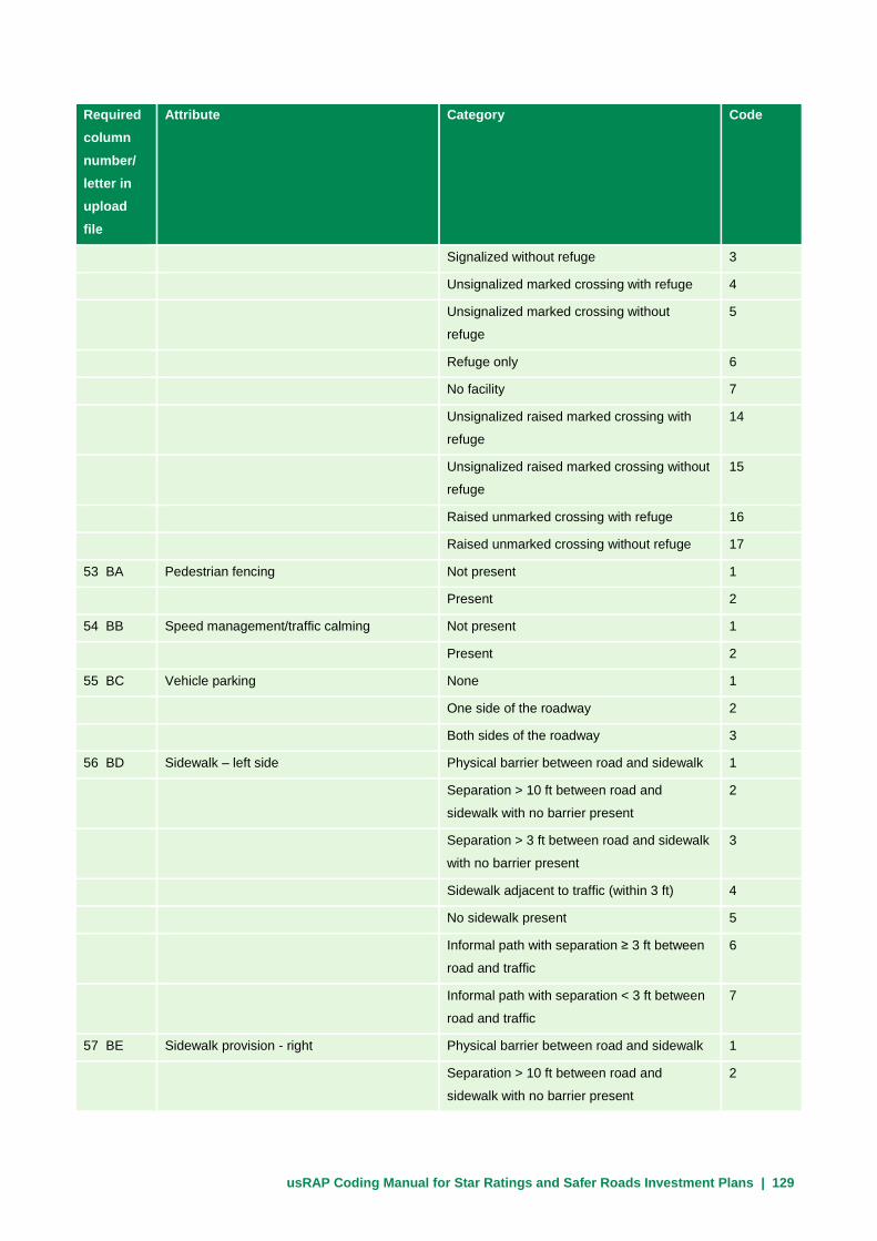
usRAP Coding Manual for Star Ratings and Safer Roads Investment Plans | 129
Required column number/ letter in upload file
Attribute Category Code
Signalized without refuge 3
Unsignalized marked crossing with refuge 4
Unsignalized marked crossing without
refuge
5
Refuge only 6
No facility 7
Unsignalized raised marked crossing with
refuge
14
Unsignalized raised marked crossing without
refuge
15
Raised unmarked crossing with refuge 16
Raised unmarked crossing without refuge 17
53 BA Pedestrian fencing Not present 1
Present 2
54 BB Speed management/traffic calming Not present 1
Present 2
55 BC Vehicle parking None 1
One side of the roadway 2
Both sides of the roadway 3
56 BD Sidewalk – left side Physical barrier between road and sidewalk 1
Separation > 10 ft between road and
sidewalk with no barrier present
2
Separation > 3 ft between road and sidewalk
with no barrier present
3
Sidewalk adjacent to traffic (within 3 ft) 4
No sidewalk present 5
Informal path with separation ≥ 3 ft between
road and traffic
6
Informal path with separation < 3 ft between
road and traffic
7
57 BE Sidewalk provision - right Physical barrier between road and sidewalk 1
Separation > 10 ft between road and
sidewalk with no barrier present
2

usRAP Coding Manual for Star Ratings and Safer Roads Investment Plans | 130
Required column number/ letter in upload file
Attribute Category Code
Separation 3 10 < 10 ft between road and
sidewalk with no barrier present
3
Sidewalk adjacent to traffic (within 3 ft) with
no barrier present
4
No sidewalk present 5
Informal path with separation ≥ 3 ft between
road and traffic
6
Informal path with separation < 3 ft between
road and traffic
7
58 BF Service road Not present 1
Present 2
59 BG Motorcycle facility Exclusive one-way motorcycle path with
barrier
1
Exclusive one-way motorcycle path without
barrier
2
Exclusive two-way motorcycle path with
barrier
3
Exclusive two-way motorcycle path without
barrier
4
Motorcycle lane on roadway 5
None 6
60 BH Bicycle facility Off-road bicycle path with barrier 1
Off-road bicycle path without barrier 2
On-road bicycle lane 3
None 4
Extra wide outside lane ≥ 14 ft 5
Signed shared roadway 6
Shared-use path 7
61 BI Roadworks No roadworks/work zone present 1
Minor roadworks/work zone in progress 2
Major roadworks/work zone in progress 3
62 BJ Sight distance Adequate 1

usRAP Coding Manual for Star Ratings and Safer Roads Investment Plans | 131
Required column number/ letter in upload file
Attribute Category Code
Poor 2
63 BK Traffic volume (AADT) Numeric (veh/day)
64 BL Motorcycle percentage in traffic flow Not recorded 1
0% 2
1% - 5% 3
6% - 10% 4
11% - 20% 5
21% - 40% 6
41% - 60% 7
61% - 80% 8
81% - 99% 9
100% 10
65 BM Pedestrian peak hour flow across the road None 1
1 to 5 pedestrians/hr 2
6 to 25 pedestrians/hr 3
26 to 50 pedestrians/hr 4
51 to 100 pedestrians/hr 5
101 to 200 pedestrians/hr 6
201 to 300 pedestrians/hr 7
301 to 400 pedestrians/hr 8
401 to 500 pedestrians/hr 9
501 to 900 pedestrians/hr 10
900+ pedestrians/hr 11
66 BN Pedestrian peak hour flow along the road –
left side
None 1
1 to 5 pedestrians/hr 2
6 to 25 pedestrians/hr 3
26 to 50 pedestrians/hr 4
51 to 100 pedestrians/hr 5
101 to 200 pedestrians/hr 6
201 to 300 pedestrians/hr 7
301 to 400 pedestrians/hr 8
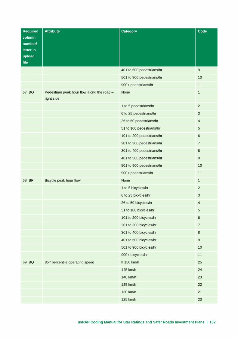
usRAP Coding Manual for Star Ratings and Safer Roads Investment Plans | 132
Required column number/ letter in upload file
Attribute Category Code
401 to 500 pedestrians/hr 9
501 to 900 pedestrians/hr 10
900+ pedestrians/hr 11
67 BO Pedestrian peak hour flow along the road –
right side
None 1
1 to 5 pedestrians/hr 2
6 to 25 pedestrians/hr 3
26 to 50 pedestrians/hr 4
51 to 100 pedestrians/hr 5
101 to 200 pedestrians/hr 6
201 to 300 pedestrians/hr 7
301 to 400 pedestrians/hr 8
401 to 500 pedestrians/hr 9
501 to 900 pedestrians/hr 10
900+ pedestrians/hr 11
68 BP Bicycle peak hour flow None 1
1 to 5 bicycles/hr 2
6 to 25 bicycles/hr 3
26 to 50 bicycles/hr 4
51 to 100 bicycles/hr 5
101 to 200 bicycles/hr 6
201 to 300 bicycles/hr 7
301 to 400 bicycles/hr 8
401 to 500 bicycles/hr 9
501 to 900 bicycles/hr 10
900+ bicycles/hr 11
69 BQ 85th percentile operating speed ≥ 150 km/h 25
145 km/h 24
140 km/h 23
135 km/h 22
130 km/h 21
125 km/h 20
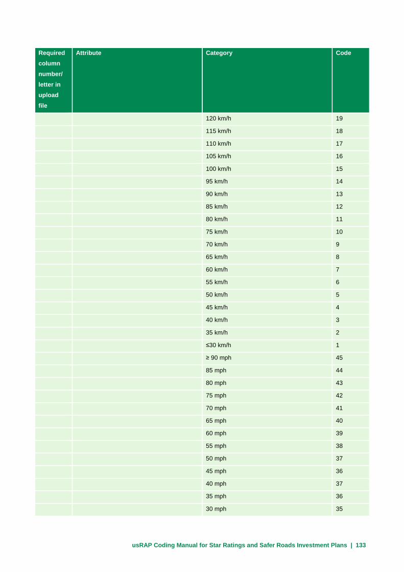
usRAP Coding Manual for Star Ratings and Safer Roads Investment Plans | 133
Required column number/ letter in upload file
Attribute Category Code
120 km/h 19
115 km/h 18
110 km/h 17
105 km/h 16
100 km/h 15
95 km/h 14
90 km/h 13
85 km/h 12
80 km/h 11
75 km/h 10
70 km/h 9
65 km/h 8
60 km/h 7
55 km/h 6
50 km/h 5
45 km/h 4
40 km/h 3
35 km/h 2
≤30 km/h 1
≥ 90 mph 45
85 mph 44
80 mph 43
75 mph 42
70 mph 41
65 mph 40
60 mph 39
55 mph 38
50 mph 37
45 mph 36
40 mph 37
35 mph 36
30 mph 35

usRAP Coding Manual for Star Ratings and Safer Roads Investment Plans | 134
Required column number/ letter in upload file
Attribute Category Code
25 mph 34
≤ 20 mph 33
70 BR Mean operating speed ≥ 150 km/h 25
145 km/h 24
140 km/h 23
135 km/h 22
130 km/h 21
125 km/h 20
120 km/h 19
115 km/h 18
110 km/h 17
105 km/h 16
100 km/h 15
95 km/h 14
90 km/h 13
85 km/h 12
80 km/h 11
75 km/h 10
70 km/h 9
65 km/h 8
60 km/h 7
55 km/h 6
50 km/h 5
45 km/h 4
40 km/h 3
35 km/h 2
≤30 km/h 1
≥ 90 mph 45
85 mph 44
80 mph 43
75 mph 42
70 mph 41

usRAP Coding Manual for Star Ratings and Safer Roads Investment Plans | 135
Required column number/ letter in upload file
Attribute Category Code
65 mph 40
60 mph 39
55 mph 38
50 mph 37
45 mph 36
40 mph 37
35 mph 36
30 mph 35
25 mph 34
≤ 20 mph 33
71 BS Roads that cars can read (optional) Meets specification 1
Does not meet specification 2
72 BT Car star rating policy target 1 star 1
2 star 2
3 star 3
4 star 4
5 star 5
Not applicable 6
73 BU Motorcycle star rating policy target 1 star 1
2 star 2
3 star 3
4 star 4
5 star 5
Not applicable 6
74 BV Pedestrian star rating policy target 1 star 1
2 star 2
3 star 3
4 star 4
5 star 5
Not applicable 6
75 BW Bicycle star rating policy target 1 star 1
2 star 2

usRAP Coding Manual for Star Ratings and Safer Roads Investment Plans | 136
Required column number/ letter in upload file
Attribute Category Code
3 star 3
4 star 4
5 star 5
Not applicable 6
76 BX Annual fatality growth multiplier Numeric (default value = 1)
77 BY School zone warning School zone with flashing beacons 1
School zone with static signs or road
markings
2
No school zone warning 3
Not applicable (no school at this location) 4
78 BZ School zone crossing guard School zone with crossing guard present at
school start and finish times
1
School zone with no crossing guard present 2
Not applicable (no school at this location) 3
NOTE: The upload file may not contain any blank spaces unless the variable in question is indicated above
as optional.
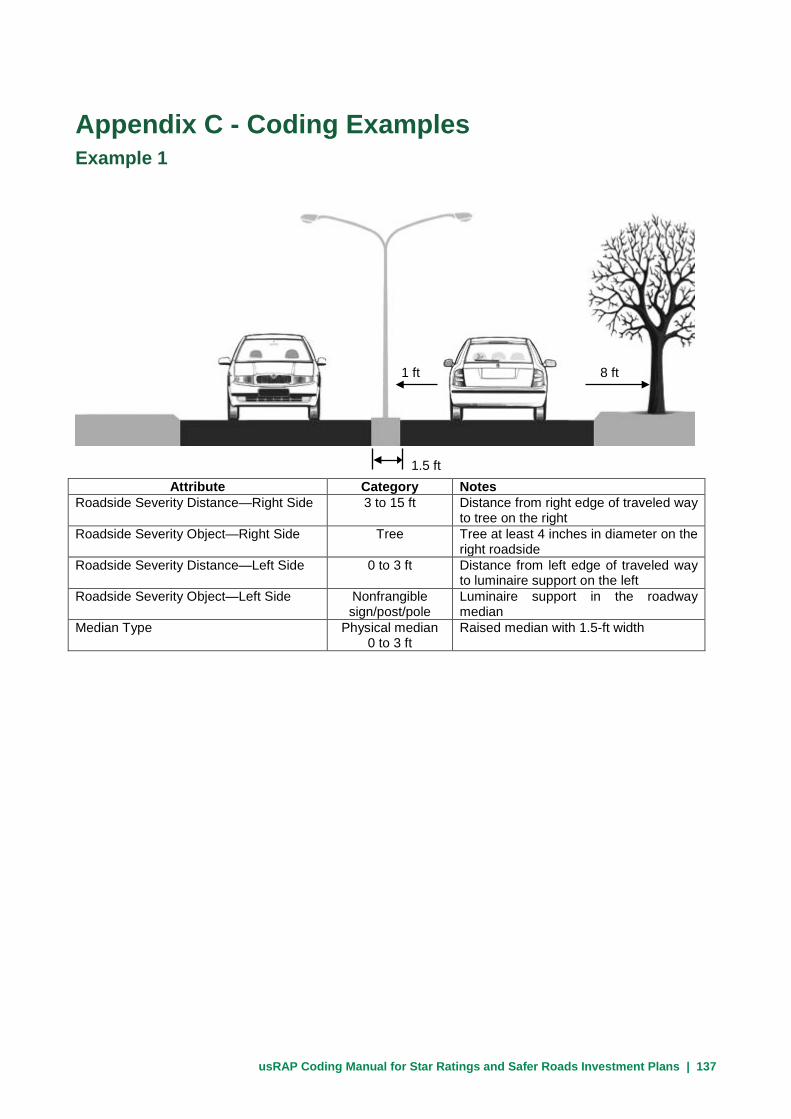
usRAP Coding Manual for Star Ratings and Safer Roads Investment Plans | 137
Appendix C - Coding Examples Example 1
Attribute Category Notes Roadside Severity Distance—Right Side 3 to 15 ft Distance from right edge of traveled way
to tree on the right Roadside Severity Object—Right Side Tree Tree at least 4 inches in diameter on the
right roadside Roadside Severity Distance—Left Side 0 to 3 ft Distance from left edge of traveled way
to luminaire support on the left Roadside Severity Object—Left Side Nonfrangible
sign/post/pole Luminaire support in the roadway median
Median Type Physical median 0 to 3 ft
Raised median with 1.5-ft width
1.5 ft
8 ft 1 ft

usRAP Coding Manual for Star Ratings and Safer Roads Investment Plans | 138
Example 2
Attribute Category Notes Roadside Severity Distance—Right Side 3 to 15 ft Distance from edge of traveled way to
tree on the right Roadside Severity Object—Right Side Tree Tree at least 4 inches in diameter on the
right roadside Roadside Severity Distance—Left Side > 30 ft Distance from left edge of traveled way
to tree on the far left roadside Roadside Severity Object—Left Side Tree Tree on the far left roadside Median Type Physical median
0 to 3 ft Raised median with 1.5-ft width
Example 3
Attribute Category Notes
Roadside Severity Distance—Right Side 3 to 15 ft Distance from edge of traveled way to luminaire support on the right roadside
Roadside Severity Object—Right Side Nonfrangible sign/post/pole
Luminaire support on the right roadside
Roadside Severity Distance—Left Side 15 to 30 ft Distance from left edge of traveled way to tree on the left roadside
Roadside Severity Object—Left Side Tree Tree on the left roadside Median Type Centerline only Undivided roadway with centerline only
1.5 ft
8 ft 36 ft
20 ft 10 ft
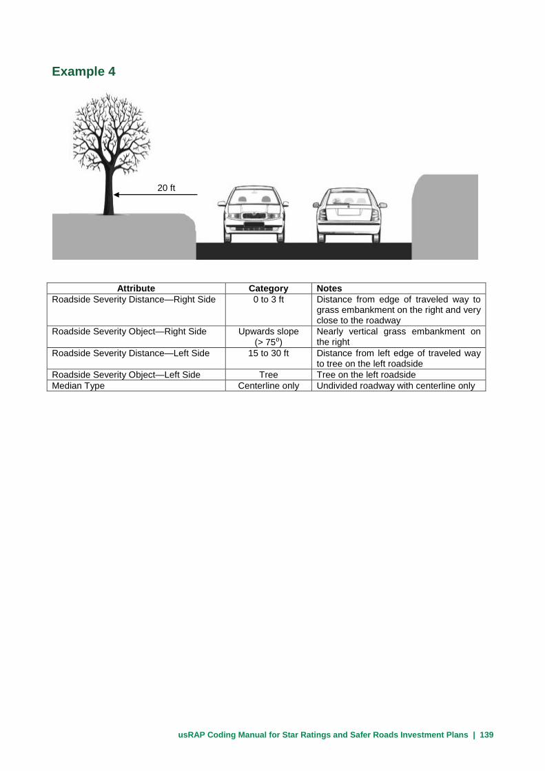
usRAP Coding Manual for Star Ratings and Safer Roads Investment Plans | 139
Example 4
Attribute Category Notes Roadside Severity Distance—Right Side 0 to 3 ft Distance from edge of traveled way to
grass embankment on the right and very close to the roadway
Roadside Severity Object—Right Side Upwards slope (> 75⁰)
Nearly vertical grass embankment on the right
Roadside Severity Distance—Left Side 15 to 30 ft Distance from left edge of traveled way to tree on the left roadside
Roadside Severity Object—Left Side Tree Tree on the left roadside Median Type Centerline only Undivided roadway with centerline only
20 ft

usRAP Coding Manual for Star Ratings and Safer Roads Investment Plans | 140
Example 5
Attribute Category Notes Roadside Severity Distance—Right Side > 30 ft Distance from edge of traveled way to
nearest roadside object on the right is greater than 30 ft
Roadside Severity Object—Right Side No object Nearest severe object on the roadside is more than 30 ft from the right edge of the traveled way
Roadside Severity Distance—Left Side 15 to 30 ft Distance from left edge of traveled way to tree on the left roadside; ditch is not deep enough to be coded
Roadside Severity Object—Left Side Tree Tree on the left roadside Median Type Centerline only Undivided roadway with centerline only
26 ft 49 ft

usRAP Coding Manual for Star Ratings and Safer Roads Investment Plans | 141
Example 6
Attribute Category Notes Roadside Severity Distance—Right Side > 30 ft Distance from edge of traveled way to
nearest roadside object on the right is greater than 30 ft
Roadside Severity Object—Right Side No object Nearest severe object on the roadside is more than 30 ft from the right edge of the traveled way
Roadside Severity Distance—Left Side 3 to 15 ft Distance from left edge of traveled way to ditch on the left roadside
Roadside Severity Object—Left Side Deep drainage ditch
Ditch on the left roadside is deep enoughto be coded
Median Type Centerline only Undivided roadway with centerline only
49 ft

usRAP Coding Manual for Star Ratings and Safer Roads Investment Plans | 142
Example 7
Attribute Category Notes Roadside Severity Distance—Right Side 3 to 15 ft Distance from edge of traveled way to
luminaire support on the right roadside Roadside Severity Object—Right Side Nonfrangible
sign/post/pole Luminaire support on the right roadside
Roadside Severity Distance—Left Side 15 to 30 ft Distance from left edge of traveled way to tree on the left roadside; grass slope is not steep enough to be recorded as a upwards slope (15⁰ to 75⁰)
Roadside Severity Object—Left Side Tree Tree on the left roadside Median Type Centerline only Undivided roadway with centerline only
30 ft 10 ft

usRAP Coding Manual for Star Ratings and Safer Roads Investment Plans | 143
Example 8
Attribute Category Notes Roadside Severity Distance—Right Side 3 to 15 ft Distance from edge of traveled way to
luminaire support on the right roadside; luminaire support is closer to the traveled way than the guardrail
Roadside Severity Object—Right Side Nonfrangible sign/post/pole
Luminaire support on the right roadside
Roadside Severity Distance—Left Side 3 to 15 ft Distance from left edge of traveled way to guardrail on the left roadside; guardrail is closer to the traveled way than the luminaire support
Roadside Severity Object—Left Side Traffic barrier - metal
Metal traffic barrier on the left roadside
Median Type Centerline only Undivided roadway with centerline only
6 ft

usRAP Coding Manual for Star Ratings and Safer Roads Investment Plans | 144
Example 9
Attribute Category Notes Roadside Severity Distance—Right Side 15 to 30 ft Distance from edge of traveled way to
luminaire support on the right roadside; luminaire support has higher risk than the downwards slope
Roadside Severity Object—Right Side Nonfrangible sign/post/pole
Luminaire support on the right roadside
Roadside Severity Distance—Left Side 0 to 3 ft Distance from left edge of traveled way to beginning of downwards slope
Roadside Severity Object—Left Side Downwards slope (> - 15⁰)
Downwards slope steeper than 15⁰
Median Type Centerline only Undivided roadway with centerline only
Example 10
Attribute Category Notes Number of Lanes for Through Traffic 1 One through traffic lane in each
direction of travel Median Type Centerline only Undivided roadway with centerline only Carriageway 3 Undivided roadway
25 ft
Gradient
20 ft

usRAP Coding Manual for Star Ratings and Safer Roads Investment Plans | 145
Example 11
Attribute Category Notes Number of Lanes for Through Traffic 2 Two through traffic lane in each
direction of travel Median Type Centerline only Undivided roadway with centerline only Carriageway 3 Undivided roadway

usRAP Coding Manual for Star Ratings and Safer Roads Investment Plans | 146
Example 12
Category Attribute Category Centerline only Median Type Centerline only
Good Delineation Poor 1 Number of lanes for
through traffic 1
Notes: Both roads are recorded as Median Type = Centerline Only because they have undivided roadways; however, because the Centerline marking for the road on the right is not present, Delineation for that road is recorded as poor.

usRAP Coding Manual for Star Ratings and Safer Roads Investment Plans | 147
Example 13
Category Attribute Category
Merge Lane Intersection type None 1 Number of lanes for
through traffic 1
Notes: On the right, the ramp leaves the main road, so this is recorded as Intersection Type = ‘none’ (diverge lanes are not recorded). On the left, the ramp joins the road so this is recorded as “Intersection Type = merge lane.