uup master plan update – factors and … master plan update – factors and method appendix 6 ......
TRANSCRIPT
UUP MASTER PLAN UPDATE – FACTORS AND METHOD
APPENDIX 6 UPDATED MASTER PLAN METHODOLOGY
RESULTS AS APPLIED TO CURRENT SURCHARGE PROJECT BLOCKS
Included herein are the complete results of the new Master Plan’s methodology as applied to current Surcharge project blocks. Upon review of this UUP Master Plan Update – Factors and Method report by City, the analysis described herein will be applied to carry out the new updated Utility Undergrounding Master Plan.
UUP MASTER PLAN UPDATE – FACTORS AND METHOD
APPENDIX 6 DISTRICT 1

Appendix 6Updated 2009 Master Plan with Applied Current Algorithms
BLOCK_ID1 CIP_ID Council District INTERSECTIONS Backlot_Poles ALLEY_Poles OH_Poles XFMR_Count Meters P_Length ServiceDrop SUB_Count1A UU310 1 11 44 19 97 27 321 10,700.49 261 0
1A1 UU215 1 31 10 50 99 22 287 12,404.99 260 01A2 UU395 1 15 17 44 86 27 339 11,468.50 259 01B UU660 1 26 17 43 95 33 263 12,089.03 181 01C UU661 1 16 10 36 70 25 610 7,313.01 187 0
1C1 UU662 1 21 51 5 109 27 557 12,744.67 248 01D UU663 1 13 24 23 99 21 415 10,670.11 184 01E UU312 1 15 16 15 71 23 524 7,194.37 245 01G UU313 1 10 16 45 89 27 473 6,768.63 152 01H UU229 1 13 42 0 95 26 255 8,645.55 205 01I UU230 1 13 26 1 68 20 285 7,626.89 157 01K UU796 1 16 70 0 143 31 306 22,747.89 273 01L UU664 1 18 28 31 121 35 633 10,896.84 181 0
1L1 UU783 1 30 11 28 116 32 430 11,828.07 246 01N UU658 1 8 20 0 86 28 160 11,376.66 138 01O UU657 1 12 20 0 113 31 333 16,405.92 289 01P UU486 1 5 25 0 33 10 22 5,262.69 22 01S UU232 1 14 11 0 84 28 319 13,770.92 270 01T UU318 1 14 6 4 71 23 318 12,361.58 260 01U UU321 1 16 24 0 66 20 291 11,680.97 286 01V UU320 1 14 20 0 70 25 363 11,986.26 325 0
1V1 UU319 1 16 10 0 85 26 354 13,791.74 314 01W UU797 1 2 45 0 66 16 79 11,272.77 36 1
1
Appendix 6Updated 2009 Master Plan with Applied Current Algorithms
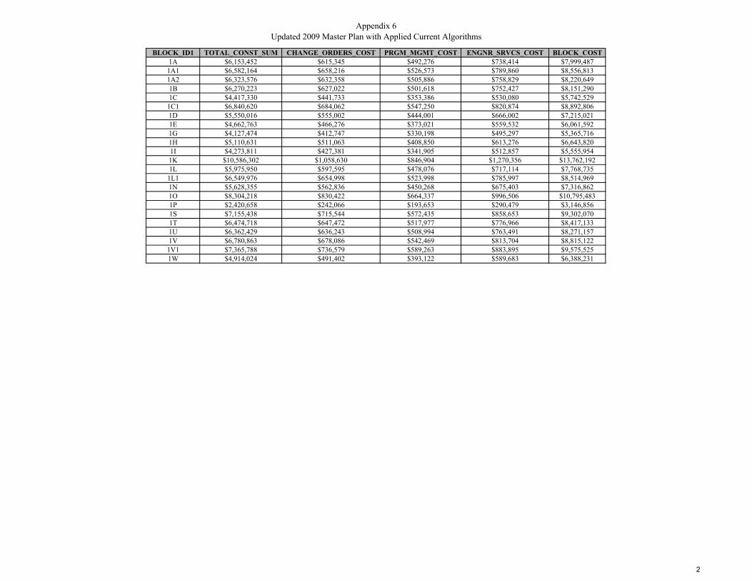
BLOCK_ID1 TOTAL_CONST_SUM CHANGE_ORDERS_COST PRGM_MGMT_COST ENGNR_SRVCS_COST BLOCK_COST1A $6,153,452 $615,345 $492,276 $738,414 $7,999,487
1A1 $6,582,164 $658,216 $526,573 $789,860 $8,556,8131A2 $6,323,576 $632,358 $505,886 $758,829 $8,220,6491B $6,270,223 $627,022 $501,618 $752,427 $8,151,2901C $4,417,330 $441,733 $353,386 $530,080 $5,742,529
1C1 $6,840,620 $684,062 $547,250 $820,874 $8,892,8061D $5,550,016 $555,002 $444,001 $666,002 $7,215,0211E $4,662,763 $466,276 $373,021 $559,532 $6,061,5921G $4,127,474 $412,747 $330,198 $495,297 $5,365,7161H $5,110,631 $511,063 $408,850 $613,276 $6,643,8201I $4,273,811 $427,381 $341,905 $512,857 $5,555,9541K $10,586,302 $1,058,630 $846,904 $1,270,356 $13,762,1921L $5,975,950 $597,595 $478,076 $717,114 $7,768,735
1L1 $6,549,976 $654,998 $523,998 $785,997 $8,514,9691N $5,628,355 $562,836 $450,268 $675,403 $7,316,8621O $8,304,218 $830,422 $664,337 $996,506 $10,795,4831P $2,420,658 $242,066 $193,653 $290,479 $3,146,8561S $7,155,438 $715,544 $572,435 $858,653 $9,302,0701T $6,474,718 $647,472 $517,977 $776,966 $8,417,1331U $6,362,429 $636,243 $508,994 $763,491 $8,271,1571V $6,780,863 $678,086 $542,469 $813,704 $8,815,122
1V1 $7,365,788 $736,579 $589,263 $883,895 $9,575,5251W $4,914,024 $491,402 $393,122 $589,683 $6,388,231
2
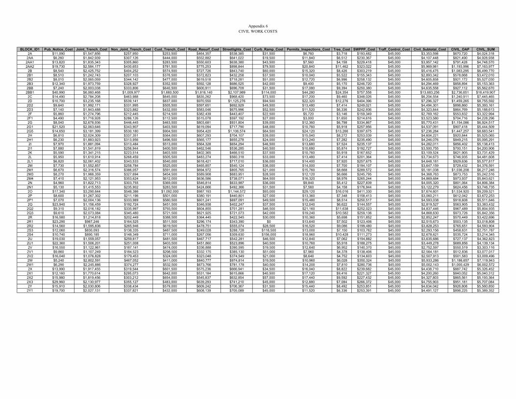
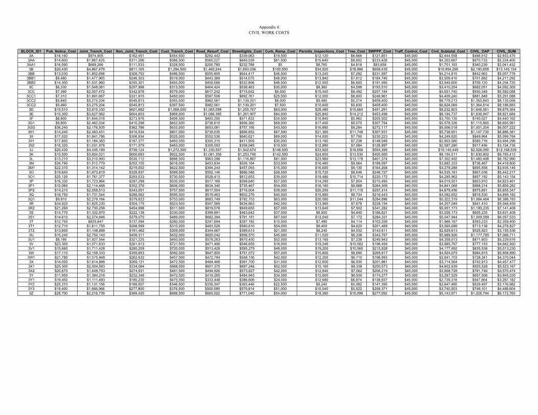
Appendix 6CIVIL WORK COSTS
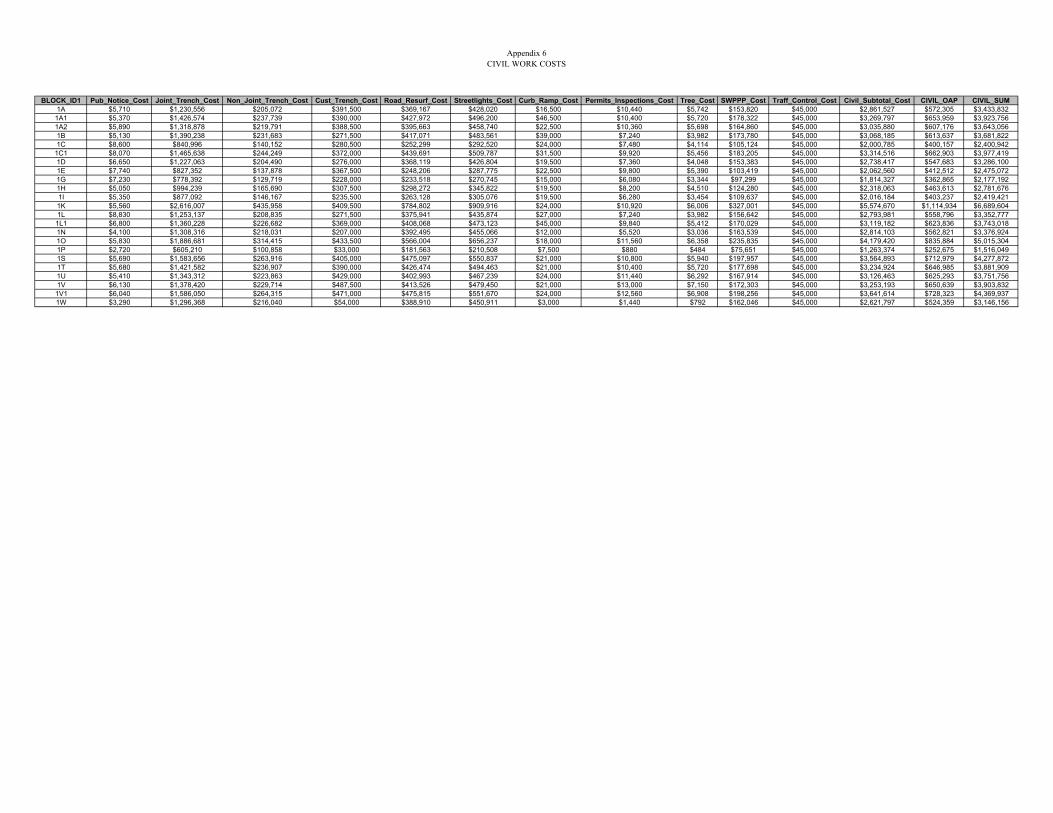
BLOCK_ID1 Pub_Notice_Cost Joint_Trench_Cost Non_Joint_Trench_Cost Cust_Trench_Cost Road_Resurf_Cost Streetlights_Cost Curb_Ramp_Cost Permits_Inspections_Cost Tree_Cost SWPPP_Cost Traff_Control_Cost Civil_Subtotal_Cost CIVIL_OAP CIVIL_SUM1A $5,710 $1,230,556 $205,072 $391,500 $369,167 $428,020 $16,500 $10,440 $5,742 $153,820 $45,000 $2,861,527 $572,305 $3,433,8321A1 $5,370 $1,426,574 $237,739 $390,000 $427,972 $496,200 $46,500 $10,400 $5,720 $178,322 $45,000 $3,269,797 $653,959 $3,923,7561A2 $5,890 $1,318,878 $219,791 $388,500 $395,663 $458,740 $22,500 $10,360 $5,698 $164,860 $45,000 $3,035,880 $607,176 $3,643,0561B $5,130 $1,390,238 $231,683 $271,500 $417,071 $483,561 $39,000 $7,240 $3,982 $173,780 $45,000 $3,068,185 $613,637 $3,681,8221C $8,600 $840,996 $140,152 $280,500 $252,299 $292,520 $24,000 $7,480 $4,114 $105,124 $45,000 $2,000,785 $400,157 $2,400,942
1C1 $8,070 $1,465,638 $244,249 $372,000 $439,691 $509,787 $31,500 $9,920 $5,456 $183,205 $45,000 $3,314,516 $662,903 $3,977,4191D $6,650 $1,227,063 $204,490 $276,000 $368,119 $426,804 $19,500 $7,360 $4,048 $153,383 $45,000 $2,738,417 $547,683 $3,286,1001E $7,740 $827,352 $137,878 $367,500 $248,206 $287,775 $22,500 $9,800 $5,390 $103,419 $45,000 $2,062,560 $412,512 $2,475,0721G $7,230 $778,392 $129,719 $228,000 $233,518 $270,745 $15,000 $6,080 $3,344 $97,299 $45,000 $1,814,327 $362,865 $2,177,1921H $5,050 $994,239 $165,690 $307,500 $298,272 $345,822 $19,500 $8,200 $4,510 $124,280 $45,000 $2,318,063 $463,613 $2,781,6761I $5,350 $877,092 $146,167 $235,500 $263,128 $305,076 $19,500 $6,280 $3,454 $109,637 $45,000 $2,016,184 $403,237 $2,419,4211K $5,560 $2,616,007 $435,958 $409,500 $784,802 $909,916 $24,000 $10,920 $6,006 $327,001 $45,000 $5,574,670 $1,114,934 $6,689,6041L $8,830 $1,253,137 $208,835 $271,500 $375,941 $435,874 $27,000 $7,240 $3,982 $156,642 $45,000 $2,793,981 $558,796 $3,352,7771L1 $6,800 $1,360,228 $226,682 $369,000 $408,068 $473,123 $45,000 $9,840 $5,412 $170,029 $45,000 $3,119,182 $623,836 $3,743,0181N $4,100 $1,308,316 $218,031 $207,000 $392,495 $455,066 $12,000 $5,520 $3,036 $163,539 $45,000 $2,814,103 $562,821 $3,376,9241O $5,830 $1,886,681 $314,415 $433,500 $566,004 $656,237 $18,000 $11,560 $6,358 $235,835 $45,000 $4,179,420 $835,884 $5,015,3041P $2,720 $605,210 $100,858 $33,000 $181,563 $210,508 $7,500 $880 $484 $75,651 $45,000 $1,263,374 $252,675 $1,516,0491S $5,690 $1,583,656 $263,916 $405,000 $475,097 $550,837 $21,000 $10,800 $5,940 $197,957 $45,000 $3,564,893 $712,979 $4,277,8721T $5,680 $1,421,582 $236,907 $390,000 $426,474 $494,463 $21,000 $10,400 $5,720 $177,698 $45,000 $3,234,924 $646,985 $3,881,9091U $5,410 $1,343,312 $223,863 $429,000 $402,993 $467,239 $24,000 $11,440 $6,292 $167,914 $45,000 $3,126,463 $625,293 $3,751,7561V $6,130 $1,378,420 $229,714 $487,500 $413,526 $479,450 $21,000 $13,000 $7,150 $172,303 $45,000 $3,253,193 $650,639 $3,903,8321V1 $6,040 $1,586,050 $264,315 $471,000 $475,815 $551,670 $24,000 $12,560 $6,908 $198,256 $45,000 $3,641,614 $728,323 $4,369,9371W $3,290 $1,296,368 $216,040 $54,000 $388,910 $450,911 $3,000 $1,440 $792 $162,046 $45,000 $2,621,797 $524,359 $3,146,156
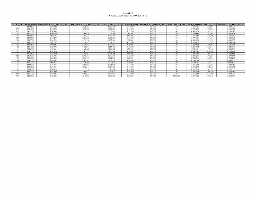
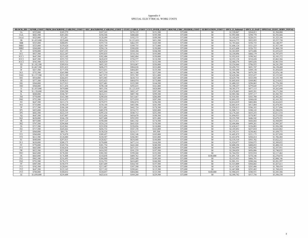
Appendix 6SPECIAL ELECTTRICAL WORK COSTS
BLOCK_ID1 XFMR_COST PRIM_BACKBONE_CABLING_COST SEC_BACKBONE_CABLING_COST CUST_CABLE_COST CUT_OVER_COST BOUND_CIRC_FEEDER_COST SUBSTATION_COST SPCL_E_Subtotal SPCL_E_OAP SPECIAL_ELEC_SERV_TOTAL1A $472,500 $132,900 $236,267 $317,588 $130,500 $75,000 $0 $1,364,755 $272,951 $1,637,706
1A1 $385,000 $154,070 $273,902 $357,321 $130,000 $75,000 $0 $1,375,293 $275,059 $1,650,3521A2 $472,500 $142,439 $253,225 $335,096 $129,500 $75,000 $0 $1,407,760 $281,552 $1,689,3121B $577,500 $150,146 $266,926 $329,764 $90,500 $75,000 $0 $1,489,836 $297,967 $1,787,8031C $437,500 $90,828 $161,471 $219,248 $93,500 $75,000 $0 $1,077,547 $215,509 $1,293,0561C1 $472,500 $158,289 $281,402 $362,230 $124,000 $75,000 $0 $1,473,421 $294,684 $1,768,1051D $367,500 $132,523 $235,596 $297,241 $92,000 $75,000 $0 $1,199,860 $239,972 $1,439,8321E $402,500 $89,354 $158,852 $231,255 $122,500 $75,000 $0 $1,079,461 $215,892 $1,295,3531G $472,500 $84,066 $149,451 $197,552 $76,000 $75,000 $0 $1,054,569 $210,914 $1,265,4831H $455,000 $107,378 $190,894 $255,100 $102,500 $75,000 $0 $1,185,872 $237,174 $1,423,0461I $350,000 $94,726 $168,402 $218,962 $78,500 $75,000 $0 $985,590 $197,118 $1,182,7081K $542,500 $282,529 $502,273 $603,280 $136,500 $75,000 $0 $2,142,082 $428,416 $2,570,4981L $612,500 $135,339 $240,602 $301,795 $90,500 $75,000 $0 $1,455,736 $291,147 $1,746,8831L1 $560,000 $146,905 $261,164 $340,217 $123,000 $75,000 $0 $1,506,286 $301,257 $1,807,5431N $490,000 $141,298 $251,197 $302,086 $69,000 $75,000 $0 $1,328,581 $265,716 $1,594,2971O $542,500 $203,762 $362,243 $458,578 $144,500 $75,000 $0 $1,786,583 $357,317 $2,143,9001P $175,000 $65,363 $116,200 $129,073 $11,000 $75,000 $0 $571,636 $114,327 $685,9631S $490,000 $171,035 $304,062 $391,916 $135,000 $75,000 $0 $1,567,013 $313,403 $1,880,4161T $402,500 $153,531 $272,944 $356,303 $130,000 $75,000 $0 $1,390,278 $278,056 $1,668,3341U $350,000 $145,078 $257,916 $346,966 $143,000 $75,000 $0 $1,317,960 $263,592 $1,581,5521V $437,500 $148,869 $264,657 $364,073 $162,500 $75,000 $0 $1,452,599 $290,520 $1,743,119
1V1 $455,000 $171,293 $304,522 $403,624 $157,000 $75,000 $0 $1,566,439 $313,288 $1,879,7271W $280,000 $140,008 $248,903 $273,639 $18,000 $75,000 $100,000 $1,135,550 $227,110 $1,362,660
1
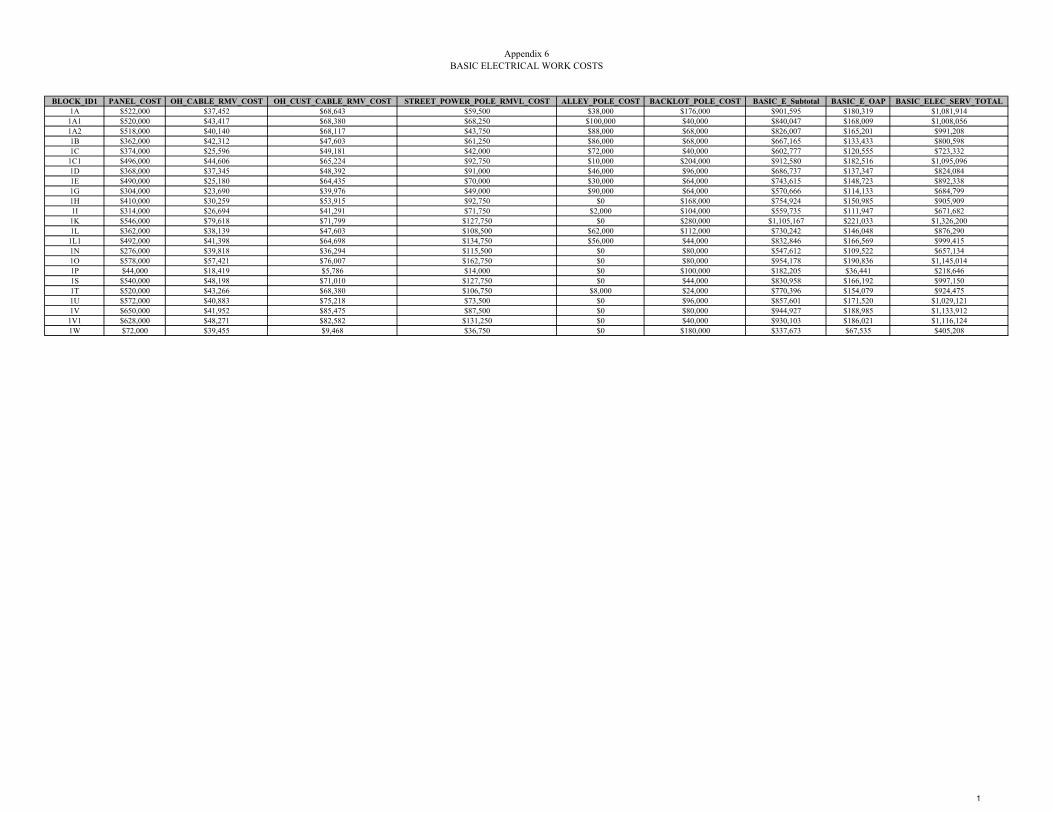
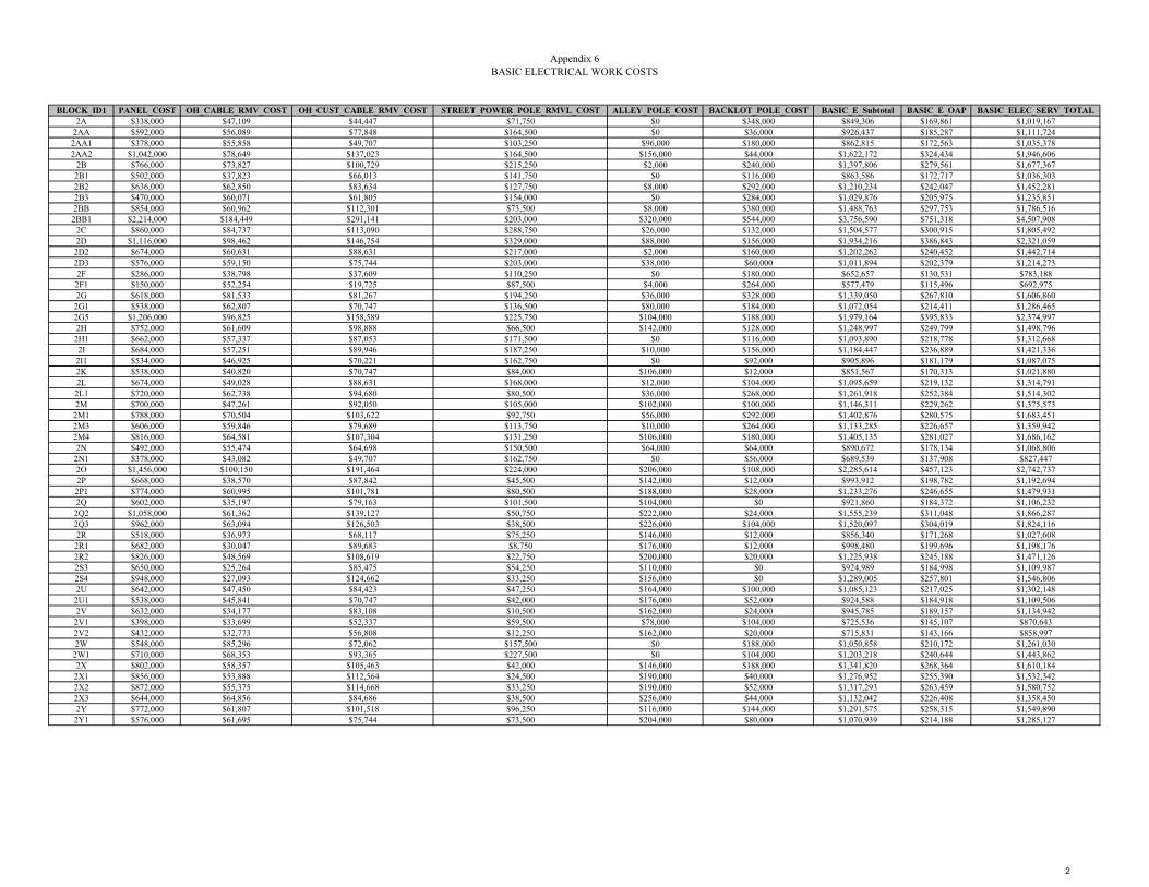
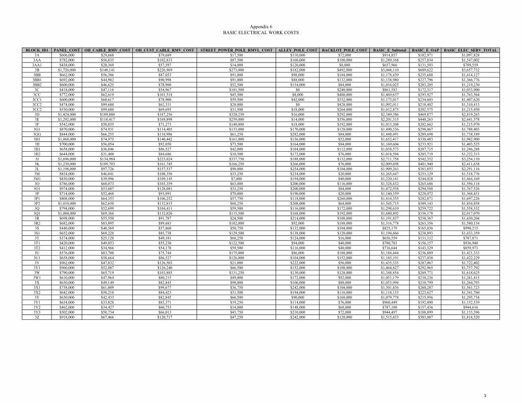
Appendix 6BASIC ELECTRICAL WORK COSTS
BLOCK_ID1 PANEL_COST OH_CABLE_RMV_COST OH_CUST_CABLE_RMV_COST STREET_POWER_POLE_RMVL_COST ALLEY_POLE_COST BACKLOT_POLE_COST BASIC_E_Subtotal BASIC_E_OAP BASIC_ELEC_SERV_TOTAL1A $522,000 $37,452 $68,643 $59,500 $38,000 $176,000 $901,595 $180,319 $1,081,9141A1 $520,000 $43,417 $68,380 $68,250 $100,000 $40,000 $840,047 $168,009 $1,008,0561A2 $518,000 $40,140 $68,117 $43,750 $88,000 $68,000 $826,007 $165,201 $991,2081B $362,000 $42,312 $47,603 $61,250 $86,000 $68,000 $667,165 $133,433 $800,5981C $374,000 $25,596 $49,181 $42,000 $72,000 $40,000 $602,777 $120,555 $723,3321C1 $496,000 $44,606 $65,224 $92,750 $10,000 $204,000 $912,580 $182,516 $1,095,0961D $368,000 $37,345 $48,392 $91,000 $46,000 $96,000 $686,737 $137,347 $824,0841E $490,000 $25,180 $64,435 $70,000 $30,000 $64,000 $743,615 $148,723 $892,3381G $304,000 $23,690 $39,976 $49,000 $90,000 $64,000 $570,666 $114,133 $684,7991H $410,000 $30,259 $53,915 $92,750 $0 $168,000 $754,924 $150,985 $905,9091I $314,000 $26,694 $41,291 $71,750 $2,000 $104,000 $559,735 $111,947 $671,6821K $546,000 $79,618 $71,799 $127,750 $0 $280,000 $1,105,167 $221,033 $1,326,2001L $362,000 $38,139 $47,603 $108,500 $62,000 $112,000 $730,242 $146,048 $876,2901L1 $492,000 $41,398 $64,698 $134,750 $56,000 $44,000 $832,846 $166,569 $999,4151N $276,000 $39,818 $36,294 $115,500 $0 $80,000 $547,612 $109,522 $657,1341O $578,000 $57,421 $76,007 $162,750 $0 $80,000 $954,178 $190,836 $1,145,0141P $44,000 $18,419 $5,786 $14,000 $0 $100,000 $182,205 $36,441 $218,6461S $540,000 $48,198 $71,010 $127,750 $0 $44,000 $830,958 $166,192 $997,1501T $520,000 $43,266 $68,380 $106,750 $8,000 $24,000 $770,396 $154,079 $924,4751U $572,000 $40,883 $75,218 $73,500 $0 $96,000 $857,601 $171,520 $1,029,1211V $650,000 $41,952 $85,475 $87,500 $0 $80,000 $944,927 $188,985 $1,133,9121V1 $628,000 $48,271 $82,582 $131,250 $0 $40,000 $930,103 $186,021 $1,116,1241W $72,000 $39,455 $9,468 $36,750 $0 $180,000 $337,673 $67,535 $405,208
1

UUP MASTER PLAN UPDATE – FACTORS AND METHOD
APPENDIX 6 DISTRICT 2
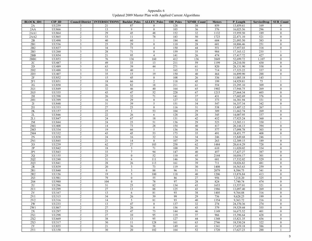
Appendix 6Updated 2009 Master Plan with Applied Current Algorithms
BLOCK_ID1 CIP_ID Council District INTERSECTIONS Backlot_Poles ALLEY_Poles OH_Poles XFMR_Count Meters P_Length ServiceDrop SUB_Count2A UU259 3 21 87 0 128 38 859 13,459.61 169 0
2AA UU866 2 13 9 0 103 36 376 16,025.56 296 02AA1 UU864 2 29 45 48 152 32 1132 15,959.50 189 02AA2 UU865 2 53 11 78 183 50 1723 22,471.10 521 0
2B UU490 3 40 60 1 184 46 604 21,093.50 383 02B1 UU536 3 25 29 0 110 28 601 10,806.46 251 02B2 UU837 3 34 73 4 150 44 551 17,957.03 318 02B3 UU260 3 28 71 0 159 35 984 17,163.12 235 12BB UU854 2 21 95 4 141 26 474 17,417.72 427 0
2BB1 UU853 2 76 136 160 412 136 3849 52,699.72 1,107 02C UU487 3 49 33 13 211 59 1199 24,210.50 430 02D UU489 3 63 39 44 271 61 820 28,131.90 558 0
2D2 UU488 3 33 40 1 165 33 714 17,323.22 337 02D3 UU407 3 35 15 19 150 40 464 16,899.90 288 02F UU852 3 15 45 0 108 26 336 11,085.18 143 1
2F1 UU851 2 18 66 2 118 45 199 14,929.81 75 12G UU850 2 26 82 18 211 61 554 23,295.10 309 0
2G1 UU849 2 32 46 40 164 65 1902 17,944.75 269 02G5 UU335 2 43 47 52 228 67 1215 27,664.34 603 02H UU398 2 26 32 71 141 37 431 17,602.69 376 0
2H1 UU399 2 16 29 0 127 32 373 16,381.94 331 02I UU848 2 31 39 5 151 34 547 16,357.34 342 0
2I1 UU333 2 27 23 0 116 31 538 13,407.12 267 12K UU157 2 25 3 53 104 29 309 11,662.74 269 02L UU846 2 22 26 6 128 28 345 14,007.95 337 0
2L1 UU847 2 24 67 18 131 42 432 17,925.24 360 02M UU844 2 24 25 51 136 29 523 13,503.11 350 1
2M1 UU408 2 14 73 28 154 40 417 20,144.13 394 02M3 UU334 2 19 66 5 136 38 577 17,098.78 303 02M4 UU332 2 43 45 53 173 35 491 18,451.77 408 02N UU838 2 24 16 32 134 34 246 15,849.68 246 1
2N1 UU845 2 21 14 0 107 29 263 12,309.15 189 02O UU239 2 62 27 103 258 62 1484 28,614.29 728 02P UU842 2 18 3 71 100 29 610 11,020.02 334 0
2P1 UU843 2 33 7 94 147 40 457 17,427.27 387 02Q UU155 2 25 0 52 110 45 2144 10,056.17 301 0
2Q2 UU240 2 31 6 111 146 36 681 17,532.02 529 02Q3 UU841 2 28 26 113 161 39 711 18,026.82 481 02R UU839 2 20 3 73 119 30 1408 10,563.63 259 0
2R1 UU840 2 0 3 88 96 51 2079 8,584.75 341 02R2 UU156 2 19 5 100 118 40 1206 13,876.84 413 02S3 UU981 2 79 0 55 86 27 956 7,218.20 325 02S4 UU980 2 104 0 78 97 28 824 7,740.74 474 02U UU296 2 31 25 82 134 43 1653 13,557.01 321 0
2U1 UU299 2 27 13 88 125 43 1986 13,097.40 269 02V UU167 2 13 6 81 93 38 1405 9,764.88 316 0
2V1 UU315 2 34 26 39 99 29 736 9,628.25 199 02V2 UU316 2 14 5 81 93 40 1354 9,363.72 216 02W UU233 1 13 47 0 137 32 274 24,370.36 274 0
2W1 UU867 2 27 26 0 156 43 379 19,529.44 355 02X UU297 2 23 47 73 144 46 1149 16,673.52 401 0
2X1 UU298 2 27 10 95 119 37 966 15,396.64 428 02X2 UU669 2 38 13 95 127 44 1348 15,821.35 436 02X3 UU317 2 30 11 128 161 63 2746 18,530.24 322 02Y UU855 2 21 36 58 149 41 1341 17,659.18 386 0
2Y1 UU158 2 30 20 102 164 52 1720 17,627.23 288 1
3
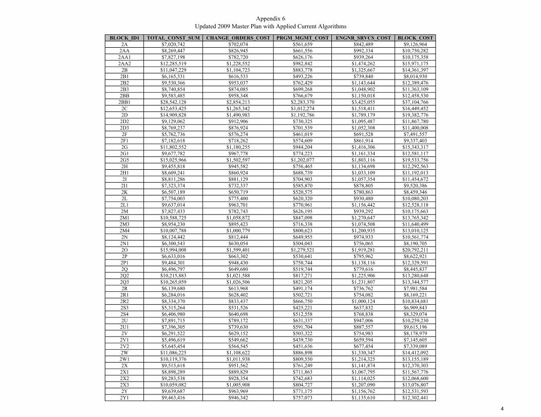
Appendix 6Updated 2009 Master Plan with Applied Current Algorithms
BLOCK_ID1 TOTAL_CONST_SUM CHANGE_ORDERS_COST PRGM_MGMT_COST ENGNR_SRVCS_COST BLOCK_COST2A $7,020,742 $702,074 $561,659 $842,489 $9,126,964
2AA $8,269,447 $826,945 $661,556 $992,334 $10,750,2822AA1 $7,827,198 $782,720 $626,176 $939,264 $10,175,3582AA2 $12,285,519 $1,228,552 $982,842 $1,474,262 $15,971,175
2B $11,047,229 $1,104,723 $883,778 $1,325,667 $14,361,3972B1 $6,165,331 $616,533 $493,226 $739,840 $8,014,9302B2 $9,530,366 $953,037 $762,429 $1,143,644 $12,389,4762B3 $8,740,854 $874,085 $699,268 $1,048,902 $11,363,1092BB $9,583,485 $958,348 $766,679 $1,150,018 $12,458,530
2BB1 $28,542,128 $2,854,213 $2,283,370 $3,425,055 $37,104,7662C $12,653,425 $1,265,342 $1,012,274 $1,518,411 $16,449,4522D $14,909,828 $1,490,983 $1,192,786 $1,789,179 $19,382,776
2D2 $9,129,062 $912,906 $730,325 $1,095,487 $11,867,7802D3 $8,769,237 $876,924 $701,539 $1,052,308 $11,400,0082F $5,762,736 $576,274 $461,019 $691,528 $7,491,557
2F1 $7,182,618 $718,262 $574,609 $861,914 $9,337,4032G $11,802,552 $1,180,255 $944,204 $1,416,306 $15,343,317
2G1 $9,677,782 $967,778 $774,223 $1,161,334 $12,581,1172G5 $15,025,966 $1,502,597 $1,202,077 $1,803,116 $19,533,7562H $9,455,818 $945,582 $756,465 $1,134,698 $12,292,563
2H1 $8,609,241 $860,924 $688,739 $1,033,109 $11,192,0132I $8,811,286 $881,129 $704,903 $1,057,354 $11,454,672
2I1 $7,323,374 $732,337 $585,870 $878,805 $9,520,3862K $6,507,189 $650,719 $520,575 $780,863 $8,459,3462L $7,754,003 $775,400 $620,320 $930,480 $10,080,203
2L1 $9,637,014 $963,701 $770,961 $1,156,442 $12,528,1182M $7,827,433 $782,743 $626,195 $939,292 $10,175,663
2M1 $10,588,725 $1,058,872 $847,098 $1,270,647 $13,765,3422M3 $8,954,230 $895,423 $716,338 $1,074,508 $11,640,4992M4 $10,007,788 $1,000,779 $800,623 $1,200,935 $13,010,1252N $8,124,442 $812,444 $649,955 $974,933 $10,561,774
2N1 $6,300,543 $630,054 $504,043 $756,065 $8,190,7052O $15,994,008 $1,599,401 $1,279,521 $1,919,281 $20,792,2112P $6,633,016 $663,302 $530,641 $795,962 $8,622,921
2P1 $9,484,301 $948,430 $758,744 $1,138,116 $12,329,5912Q $6,496,797 $649,680 $519,744 $779,616 $8,445,837
2Q2 $10,215,883 $1,021,588 $817,271 $1,225,906 $13,280,6482Q3 $10,265,059 $1,026,506 $821,205 $1,231,807 $13,344,5772R $6,139,680 $613,968 $491,174 $736,762 $7,981,584
2R1 $6,284,016 $628,402 $502,721 $754,082 $8,169,2212R2 $8,334,370 $833,437 $666,750 $1,000,124 $10,834,6812S3 $5,315,264 $531,526 $425,221 $637,832 $6,909,8432S4 $6,406,980 $640,698 $512,558 $768,838 $8,329,0742U $7,891,715 $789,172 $631,337 $947,006 $10,259,230
2U1 $7,396,305 $739,630 $591,704 $887,557 $9,615,1962V $6,291,522 $629,152 $503,322 $754,983 $8,178,979
2V1 $5,496,619 $549,662 $439,730 $659,594 $7,145,6052V2 $5,645,454 $564,545 $451,636 $677,454 $7,339,0892W $11,086,225 $1,108,622 $886,898 $1,330,347 $14,412,092
2W1 $10,119,376 $1,011,938 $809,550 $1,214,325 $13,155,1892X $9,515,618 $951,562 $761,249 $1,141,874 $12,370,303
2X1 $8,898,289 $889,829 $711,863 $1,067,795 $11,567,7762X2 $9,283,538 $928,354 $742,683 $1,114,025 $12,068,6002X3 $10,059,082 $1,005,908 $804,727 $1,207,090 $13,076,8072Y $9,639,687 $963,969 $771,175 $1,156,762 $12,531,593
2Y1 $9,463,416 $946,342 $757,073 $1,135,610 $12,302,441
4
Appendix 6CIVIL WORK COSTS
BLOCK_ID1 Pub_Notice_Cost Joint_Trench_Cost Non_Joint_Trench_Cost Cust_Trench_Cost Road_Resurf_Cost Streetlights_Cost Curb_Ramp_Cost Permits_Inspections_Cost Tree_Cost SWPPP_Cost Traff_Control_Cost Civil_Subtotal_Cost CIVIL_OAP CIVIL_SUM2A $11,090 $1,547,856 $257,950 $253,500 $464,357 $538,385 $31,500 $6,760 $3,718 $193,482 $45,000 $3,353,598 $670,720 $4,024,318
2AA $6,260 $1,842,939 $307,126 $444,000 $552,882 $641,022 $19,500 $11,840 $6,512 $230,367 $45,000 $4,107,448 $821,490 $4,928,9382AA1 $13,820 $1,835,343 $305,860 $283,500 $550,603 $638,380 $43,500 $7,560 $4,158 $229,418 $45,000 $3,957,142 $791,428 $4,748,5702AA2 $19,730 $2,584,177 $430,653 $781,500 $775,253 $898,844 $79,500 $20,840 $11,462 $323,022 $45,000 $5,969,981 $1,193,996 $7,163,977
2B $8,540 $2,425,752 $404,252 $574,500 $727,726 $843,740 $60,000 $15,320 $8,426 $303,219 $45,000 $5,416,475 $1,083,295 $6,499,7702B1 $8,510 $1,242,743 $207,103 $376,500 $372,823 $432,258 $37,500 $10,040 $5,522 $155,343 $45,000 $2,893,342 $578,668 $3,472,0102B2 $8,010 $2,065,059 $344,142 $477,000 $619,518 $718,281 $51,000 $12,720 $6,996 $258,132 $45,000 $4,605,858 $921,172 $5,527,0302B3 $12,340 $1,973,759 $328,927 $352,500 $592,128 $686,525 $42,000 $9,400 $5,170 $246,720 $45,000 $4,294,469 $858,894 $5,153,3632BB $7,240 $2,003,038 $333,806 $640,500 $600,911 $696,709 $31,500 $17,080 $9,394 $250,380 $45,000 $4,635,558 $927,112 $5,562,670
2BB1 $40,990 $6,060,468 $1,009,977 $1,660,500 $1,818,140 $2,107,989 $114,000 $44,280 $24,354 $757,558 $45,000 $13,683,256 $2,736,651 $16,419,9072C $14,490 $2,784,208 $463,988 $645,000 $835,262 $968,420 $73,500 $17,200 $9,460 $348,026 $45,000 $6,204,554 $1,240,911 $7,445,4652D $10,700 $3,235,168 $539,141 $837,000 $970,550 $1,125,276 $94,500 $22,320 $12,276 $404,396 $45,000 $7,296,327 $1,459,265 $8,755,592
2D2 $9,640 $1,992,171 $331,995 $505,500 $597,651 $692,929 $49,500 $13,480 $7,414 $249,021 $45,000 $4,494,301 $898,860 $5,393,1612D3 $7,140 $1,943,488 $323,882 $432,000 $583,046 $675,996 $52,500 $11,520 $6,336 $242,936 $45,000 $4,323,844 $864,769 $5,188,6132F $5,860 $1,274,796 $212,445 $214,500 $382,439 $443,407 $22,500 $5,720 $3,146 $159,349 $45,000 $2,769,162 $553,832 $3,322,994
2F1 $4,490 $1,716,928 $286,126 $112,500 $515,078 $597,192 $27,000 $3,000 $1,650 $214,616 $45,000 $3,523,580 $704,716 $4,228,2962G $8,040 $2,678,936 $446,445 $463,500 $803,681 $931,804 $39,000 $12,360 $6,798 $334,867 $45,000 $5,770,431 $1,154,086 $6,924,517
2G1 $21,520 $2,063,646 $343,907 $403,500 $619,094 $717,790 $48,000 $10,760 $5,918 $257,956 $45,000 $4,537,091 $907,418 $5,444,5092G5 $14,650 $3,181,399 $530,180 $904,500 $954,420 $1,106,574 $64,500 $24,120 $13,266 $397,675 $45,000 $7,236,284 $1,447,257 $8,683,5412H $6,810 $2,024,309 $337,351 $564,000 $607,293 $704,107 $39,000 $15,040 $8,272 $253,039 $45,000 $4,604,221 $920,844 $5,525,065
2H1 $6,230 $1,883,923 $313,956 $496,500 $565,177 $655,278 $24,000 $13,240 $7,282 $235,490 $45,000 $4,246,076 $849,215 $5,095,2912I $7,970 $1,881,094 $313,484 $513,000 $564,328 $654,294 $46,500 $13,680 $7,524 $235,137 $45,000 $4,282,011 $856,402 $5,138,413
2I1 $7,880 $1,541,819 $256,944 $400,500 $462,546 $536,285 $40,500 $10,680 $5,874 $192,727 $45,000 $3,500,755 $700,151 $4,200,9062K $5,590 $1,341,215 $223,514 $403,500 $402,365 $466,510 $37,500 $10,760 $5,918 $167,652 $45,000 $3,109,524 $621,905 $3,731,4292L $5,950 $1,610,914 $268,459 $505,500 $483,274 $560,318 $33,000 $13,480 $7,414 $201,364 $45,000 $3,734,673 $746,935 $4,481,6082L1 $6,820 $2,061,402 $343,533 $540,000 $618,421 $717,010 $36,000 $14,400 $7,920 $257,675 $45,000 $4,648,181 $929,636 $5,577,8172M $7,730 $1,552,857 $258,784 $525,000 $465,857 $540,124 $36,000 $14,000 $7,700 $194,107 $45,000 $3,647,159 $729,432 $4,376,5912M1 $6,670 $2,316,574 $386,057 $591,000 $694,972 $805,765 $21,000 $15,760 $8,668 $289,572 $45,000 $5,181,038 $1,036,208 $6,217,2462M3 $8,270 $1,966,359 $327,694 $454,500 $589,908 $683,951 $28,500 $12,120 $6,666 $245,795 $45,000 $4,368,763 $873,753 $5,242,5162M4 $7,410 $2,121,953 $353,624 $612,000 $636,586 $738,071 $64,500 $16,320 $8,976 $265,244 $45,000 $4,869,684 $973,937 $5,843,6212N $4,960 $1,822,713 $303,755 $369,000 $546,814 $633,987 $36,000 $9,840 $5,412 $227,839 $45,000 $4,005,320 $801,064 $4,806,384
2N1 $5,130 $1,415,553 $235,902 $283,500 $424,666 $492,366 $31,500 $7,560 $4,158 $176,944 $45,000 $3,122,279 $624,456 $3,746,7352O $17,340 $3,290,644 $548,386 $1,092,000 $987,193 $1,144,572 $93,000 $29,120 $16,016 $411,330 $45,000 $7,674,601 $1,534,920 $9,209,5212P $8,600 $1,267,302 $211,196 $501,000 $380,191 $440,801 $27,000 $13,360 $7,348 $158,413 $45,000 $3,060,211 $612,042 $3,672,2532P1 $7,070 $2,004,136 $333,989 $580,500 $601,241 $697,091 $49,500 $15,480 $8,514 $250,517 $45,000 $4,593,038 $918,608 $5,511,6462Q $23,940 $1,156,459 $192,724 $451,500 $346,938 $402,247 $37,500 $12,040 $6,622 $144,557 $45,000 $2,819,527 $563,905 $3,383,432
2Q2 $9,310 $2,016,182 $335,997 $793,500 $604,855 $701,281 $46,500 $21,160 $11,638 $252,023 $45,000 $4,837,446 $967,489 $5,804,9352Q3 $9,610 $2,073,084 $345,480 $721,500 $621,925 $721,073 $42,000 $19,240 $10,582 $259,136 $45,000 $4,868,630 $973,726 $5,842,3562R $16,580 $1,214,818 $202,449 $388,500 $364,445 $422,545 $30,000 $10,360 $5,698 $151,852 $45,000 $2,852,247 $570,449 $3,422,696
2R1 $23,290 $987,246 $164,525 $511,500 $296,174 $343,390 $0 $13,640 $7,502 $123,406 $45,000 $2,515,673 $503,135 $3,018,8082R2 $14,560 $1,595,836 $265,946 $619,500 $478,751 $555,074 $28,500 $16,520 $9,086 $199,480 $45,000 $3,828,253 $765,651 $4,593,9042S3 $12,060 $830,093 $138,335 $487,500 $249,028 $288,728 $118,500 $13,000 $7,150 $103,762 $45,000 $2,293,156 $458,631 $2,751,7872S4 $10,740 $890,185 $148,349 $711,000 $267,056 $309,630 $156,000 $18,960 $10,428 $111,273 $45,000 $2,678,621 $535,724 $3,214,3452U $19,030 $1,559,057 $259,817 $481,500 $467,717 $542,281 $46,500 $12,840 $7,062 $194,882 $45,000 $3,635,686 $727,137 $4,362,823
2U1 $22,360 $1,506,201 $251,008 $403,500 $451,860 $523,896 $40,500 $10,760 $5,918 $188,275 $45,000 $3,449,278 $689,856 $4,139,1342V $16,550 $1,122,961 $187,141 $474,000 $336,888 $390,595 $19,500 $12,640 $6,952 $140,370 $45,000 $2,752,597 $550,519 $3,303,1162V1 $9,860 $1,107,249 $184,523 $298,500 $332,175 $385,130 $51,000 $7,960 $4,378 $138,406 $45,000 $2,564,181 $512,836 $3,077,0172V2 $16,040 $1,076,828 $179,453 $324,000 $323,048 $374,549 $21,000 $8,640 $4,752 $134,603 $45,000 $2,507,913 $501,583 $3,009,4962W $5,240 $2,802,591 $467,052 $411,000 $840,777 $974,814 $19,500 $10,960 $6,028 $350,324 $45,000 $5,933,286 $1,186,657 $7,119,9432W1 $6,290 $2,245,886 $374,277 $532,500 $673,766 $781,178 $40,500 $14,200 $7,810 $280,736 $45,000 $5,002,143 $1,000,429 $6,002,5722X $13,990 $1,917,455 $319,544 $601,500 $575,236 $666,941 $34,500 $16,040 $8,822 $239,682 $45,000 $4,438,710 $887,742 $5,326,452
2X1 $12,160 $1,770,614 $295,073 $642,000 $531,184 $615,866 $40,500 $17,120 $9,416 $221,327 $45,000 $4,200,260 $840,052 $5,040,3122X2 $15,980 $1,819,456 $303,212 $654,000 $545,837 $632,854 $57,000 $17,440 $9,592 $227,432 $45,000 $4,327,803 $865,561 $5,193,3642X3 $29,960 $2,130,977 $355,127 $483,000 $639,293 $741,210 $45,000 $12,880 $7,084 $266,372 $45,000 $4,755,903 $951,181 $5,707,0842Y $15,910 $2,030,806 $338,434 $579,000 $609,242 $706,367 $31,500 $15,440 $8,492 $253,851 $45,000 $4,634,042 $926,808 $5,560,850
2Y1 $19,700 $2,027,131 $337,821 $432,000 $608,139 $705,089 $45,000 $11,520 $6,336 $253,391 $45,000 $4,491,127 $898,225 $5,389,352

Appendix 6SPECIAL ELECTTRICAL WORK COSTS
BLOCK_ID1 XFMR_COST PRIM_BACKBONE_CABLING_COST SEC_BACKBONE_CABLING_COST CUST_CABLE_COST CUT_OVER_COST BOUND_CIRC_FEEDER_COST SUBSTATION_COST SPCL_E_Subtotal SPCL_E_OAP SPECIAL_ELEC_SERV_TOTAL2A $665,000 $167,168 $297,188 $358,858 $84,500 $75,000 $0 $1,647,714 $329,543 $1,977,257
2AA $630,000 $199,037 $353,844 $451,440 $148,000 $75,000 $0 $1,857,321 $371,464 $2,228,7852AA1 $560,000 $198,217 $352,386 $422,605 $94,500 $75,000 $0 $1,702,708 $340,542 $2,043,2502AA2 $875,000 $279,091 $496,162 $660,027 $260,500 $75,000 $0 $2,645,780 $529,156 $3,174,936
2B $805,000 $261,981 $465,744 $592,518 $191,500 $75,000 $0 $2,391,743 $478,349 $2,870,0922B1 $490,000 $134,216 $238,607 $317,525 $125,500 $75,000 $0 $1,380,848 $276,170 $1,657,0182B2 $770,000 $223,026 $396,491 $502,362 $159,000 $75,000 $0 $2,125,879 $425,176 $2,551,0552B3 $612,500 $213,166 $378,962 $462,572 $117,500 $75,000 $100,000 $1,959,700 $391,940 $2,351,6402BB $455,000 $216,328 $384,583 $517,505 $213,500 $75,000 $0 $1,861,916 $372,383 $2,234,2992BB1 $2,380,000 $654,531 $1,163,610 $1,518,620 $553,500 $75,000 $0 $6,345,261 $1,269,052 $7,614,313
2C $1,032,500 $300,694 $534,568 $677,628 $215,000 $75,000 $0 $2,835,390 $567,078 $3,402,4682D $1,067,500 $349,398 $621,152 $802,264 $279,000 $75,000 $0 $3,194,314 $638,863 $3,833,177
2D2 $577,500 $215,154 $382,497 $492,338 $168,500 $75,000 $0 $1,910,989 $382,198 $2,293,1872D3 $700,000 $209,897 $373,150 $469,912 $144,000 $75,000 $0 $1,971,959 $394,392 $2,366,3512F $455,000 $137,678 $244,761 $296,523 $71,500 $75,000 $100,000 $1,380,462 $276,092 $1,656,554
2F1 $787,500 $185,428 $329,650 $369,378 $37,500 $75,000 $100,000 $1,884,456 $376,891 $2,261,3472G $1,067,500 $289,325 $514,356 $625,298 $154,500 $75,000 $0 $2,725,979 $545,196 $3,271,175
2G1 $1,137,500 $222,874 $396,220 $489,579 $134,500 $75,000 $0 $2,455,673 $491,135 $2,946,8082G5 $1,172,500 $343,591 $610,829 $802,770 $301,500 $75,000 $0 $3,306,190 $661,238 $3,967,4282H $647,500 $218,625 $388,667 $508,839 $188,000 $75,000 $0 $2,026,631 $405,326 $2,431,957
2H1 $560,000 $203,464 $361,713 $468,725 $165,500 $75,000 $0 $1,834,402 $366,880 $2,201,2822I $595,000 $203,158 $361,170 $470,953 $171,000 $75,000 $0 $1,876,281 $375,256 $2,251,5372I1 $542,500 $166,516 $296,029 $382,616 $133,500 $75,000 $100,000 $1,696,161 $339,232 $2,035,3932K $507,500 $144,851 $257,513 $342,203 $134,500 $75,000 $0 $1,461,567 $292,313 $1,753,8802L $490,000 $173,979 $309,296 $414,562 $168,500 $75,000 $0 $1,631,337 $326,267 $1,957,6042L1 $735,000 $222,631 $395,789 $512,326 $180,000 $75,000 $0 $2,120,746 $424,149 $2,544,8952M $507,500 $167,709 $298,149 $406,033 $175,000 $75,000 $100,000 $1,729,391 $345,878 $2,075,2692M1 $700,000 $250,190 $444,782 $573,051 $197,000 $75,000 $0 $2,240,023 $448,005 $2,688,0282M3 $665,000 $212,367 $377,541 $478,402 $151,500 $75,000 $0 $1,959,810 $391,962 $2,351,7722M4 $612,500 $229,171 $407,415 $536,918 $204,000 $75,000 $0 $2,065,004 $413,001 $2,478,0052N $595,000 $196,853 $349,961 $434,563 $123,000 $75,000 $100,000 $1,874,377 $374,875 $2,249,2522N1 $507,500 $152,880 $271,786 $336,968 $94,500 $75,000 $0 $1,438,634 $287,727 $1,726,3612O $1,085,000 $355,390 $631,804 $856,931 $364,000 $75,000 $0 $3,368,125 $673,625 $4,041,7502P $507,500 $136,869 $243,322 $343,700 $167,000 $75,000 $0 $1,473,391 $294,678 $1,768,069
2P1 $700,000 $216,447 $384,794 $507,529 $193,500 $75,000 $0 $2,077,270 $415,454 $2,492,7242Q $787,500 $124,898 $222,040 $312,673 $150,500 $75,000 $0 $1,672,611 $334,522 $2,007,133
2Q2 $630,000 $217,748 $387,107 $546,196 $264,500 $75,000 $0 $2,120,551 $424,110 $2,544,6612Q3 $682,500 $223,893 $398,032 $545,564 $240,500 $75,000 $0 $2,165,489 $433,098 $2,598,5872R $525,000 $131,200 $233,245 $313,868 $129,500 $75,000 $0 $1,407,813 $281,563 $1,689,3762R1 $892,500 $106,623 $189,551 $288,353 $170,500 $75,000 $0 $1,722,527 $344,505 $2,067,0322R2 $700,000 $172,350 $306,401 $430,866 $206,500 $75,000 $0 $1,891,117 $378,223 $2,269,3402S3 $472,500 $89,650 $159,378 $252,214 $162,500 $75,000 $0 $1,211,242 $242,248 $1,453,4902S4 $490,000 $96,140 $170,916 $302,468 $237,000 $75,000 $0 $1,371,524 $274,305 $1,645,8292U $752,500 $168,378 $299,339 $399,903 $160,500 $75,000 $0 $1,855,620 $371,124 $2,226,744
2U1 $752,500 $162,670 $289,191 $375,860 $134,500 $75,000 $0 $1,789,721 $357,944 $2,147,6652V $665,000 $121,280 $215,609 $309,664 $158,000 $75,000 $0 $1,544,553 $308,911 $1,853,464
2V1 $507,500 $119,583 $212,592 $276,624 $99,500 $75,000 $0 $1,290,799 $258,160 $1,548,9592V2 $700,000 $116,297 $206,751 $274,753 $108,000 $75,000 $0 $1,480,801 $296,160 $1,776,9612W $560,000 $302,680 $538,098 $641,599 $137,000 $75,000 $0 $2,254,377 $450,875 $2,705,252
2W1 $752,500 $242,556 $431,210 $548,686 $177,500 $75,000 $0 $2,227,452 $445,490 $2,672,9422X $805,000 $207,085 $368,151 $493,416 $200,500 $75,000 $0 $2,149,152 $429,830 $2,578,982
2X1 $647,500 $191,226 $339,958 $470,345 $214,000 $75,000 $0 $1,938,029 $387,606 $2,325,6352X2 $770,000 $196,501 $349,335 $482,349 $218,000 $75,000 $0 $2,091,185 $418,237 $2,509,4222X3 $1,102,500 $230,146 $409,148 $516,829 $161,000 $75,000 $0 $2,494,623 $498,925 $2,993,5482Y $717,500 $219,327 $389,915 $512,714 $193,000 $75,000 $0 $2,107,456 $421,491 $2,528,947
2Y1 $910,000 $218,930 $389,209 $486,975 $144,000 $75,000 $100,000 $2,324,114 $464,823 $2,788,937
2
Appendix 6BASIC ELECTRICAL WORK COSTS
BLOCK_ID1 PANEL_COST OH_CABLE_RMV_COST OH_CUST_CABLE_RMV_COST STREET_POWER_POLE_RMVL_COST ALLEY_POLE_COST BACKLOT_POLE_COST BASIC_E_Subtotal BASIC_E_OAP BASIC_ELEC_SERV_TOTAL2A $338,000 $47,109 $44,447 $71,750 $0 $348,000 $849,306 $169,861 $1,019,167
2AA $592,000 $56,089 $77,848 $164,500 $0 $36,000 $926,437 $185,287 $1,111,7242AA1 $378,000 $55,858 $49,707 $103,250 $96,000 $180,000 $862,815 $172,563 $1,035,3782AA2 $1,042,000 $78,649 $137,023 $164,500 $156,000 $44,000 $1,622,172 $324,434 $1,946,606
2B $766,000 $73,827 $100,729 $215,250 $2,000 $240,000 $1,397,806 $279,561 $1,677,3672B1 $502,000 $37,823 $66,013 $141,750 $0 $116,000 $863,586 $172,717 $1,036,3032B2 $636,000 $62,850 $83,634 $127,750 $8,000 $292,000 $1,210,234 $242,047 $1,452,2812B3 $470,000 $60,071 $61,805 $154,000 $0 $284,000 $1,029,876 $205,975 $1,235,8512BB $854,000 $60,962 $112,301 $73,500 $8,000 $380,000 $1,488,763 $297,753 $1,786,5162BB1 $2,214,000 $184,449 $291,141 $203,000 $320,000 $544,000 $3,756,590 $751,318 $4,507,908
2C $860,000 $84,737 $113,090 $288,750 $26,000 $132,000 $1,504,577 $300,915 $1,805,4922D $1,116,000 $98,462 $146,754 $329,000 $88,000 $156,000 $1,934,216 $386,843 $2,321,0592D2 $674,000 $60,631 $88,631 $217,000 $2,000 $160,000 $1,202,262 $240,452 $1,442,7142D3 $576,000 $59,150 $75,744 $203,000 $38,000 $60,000 $1,011,894 $202,379 $1,214,2732F $286,000 $38,798 $37,609 $110,250 $0 $180,000 $652,657 $130,531 $783,1882F1 $150,000 $52,254 $19,725 $87,500 $4,000 $264,000 $577,479 $115,496 $692,9752G $618,000 $81,533 $81,267 $194,250 $36,000 $328,000 $1,339,050 $267,810 $1,606,8602G1 $538,000 $62,807 $70,747 $136,500 $80,000 $184,000 $1,072,054 $214,411 $1,286,4652G5 $1,206,000 $96,825 $158,589 $225,750 $104,000 $188,000 $1,979,164 $395,833 $2,374,9972H $752,000 $61,609 $98,888 $66,500 $142,000 $128,000 $1,248,997 $249,799 $1,498,7962H1 $662,000 $57,337 $87,053 $171,500 $0 $116,000 $1,093,890 $218,778 $1,312,6682I $684,000 $57,251 $89,946 $187,250 $10,000 $156,000 $1,184,447 $236,889 $1,421,3362I1 $534,000 $46,925 $70,221 $162,750 $0 $92,000 $905,896 $181,179 $1,087,0752K $538,000 $40,820 $70,747 $84,000 $106,000 $12,000 $851,567 $170,313 $1,021,8802L $674,000 $49,028 $88,631 $168,000 $12,000 $104,000 $1,095,659 $219,132 $1,314,7912L1 $720,000 $62,738 $94,680 $80,500 $36,000 $268,000 $1,261,918 $252,384 $1,514,3022M $700,000 $47,261 $92,050 $105,000 $102,000 $100,000 $1,146,311 $229,262 $1,375,5732M1 $788,000 $70,504 $103,622 $92,750 $56,000 $292,000 $1,402,876 $280,575 $1,683,4512M3 $606,000 $59,846 $79,689 $113,750 $10,000 $264,000 $1,133,285 $226,657 $1,359,9422M4 $816,000 $64,581 $107,304 $131,250 $106,000 $180,000 $1,405,135 $281,027 $1,686,1622N $492,000 $55,474 $64,698 $150,500 $64,000 $64,000 $890,672 $178,134 $1,068,8062N1 $378,000 $43,082 $49,707 $162,750 $0 $56,000 $689,539 $137,908 $827,4472O $1,456,000 $100,150 $191,464 $224,000 $206,000 $108,000 $2,285,614 $457,123 $2,742,7372P $668,000 $38,570 $87,842 $45,500 $142,000 $12,000 $993,912 $198,782 $1,192,6942P1 $774,000 $60,995 $101,781 $80,500 $188,000 $28,000 $1,233,276 $246,655 $1,479,9312Q $602,000 $35,197 $79,163 $101,500 $104,000 $0 $921,860 $184,372 $1,106,232
2Q2 $1,058,000 $61,362 $139,127 $50,750 $222,000 $24,000 $1,555,239 $311,048 $1,866,2872Q3 $962,000 $63,094 $126,503 $38,500 $226,000 $104,000 $1,520,097 $304,019 $1,824,1162R $518,000 $36,973 $68,117 $75,250 $146,000 $12,000 $856,340 $171,268 $1,027,608
2R1 $682,000 $30,047 $89,683 $8,750 $176,000 $12,000 $998,480 $199,696 $1,198,1762R2 $826,000 $48,569 $108,619 $22,750 $200,000 $20,000 $1,225,938 $245,188 $1,471,1262S3 $650,000 $25,264 $85,475 $54,250 $110,000 $0 $924,989 $184,998 $1,109,9872S4 $948,000 $27,093 $124,662 $33,250 $156,000 $0 $1,289,005 $257,801 $1,546,8062U $642,000 $47,450 $84,423 $47,250 $164,000 $100,000 $1,085,123 $217,025 $1,302,1482U1 $538,000 $45,841 $70,747 $42,000 $176,000 $52,000 $924,588 $184,918 $1,109,5062V $632,000 $34,177 $83,108 $10,500 $162,000 $24,000 $945,785 $189,157 $1,134,9422V1 $398,000 $33,699 $52,337 $59,500 $78,000 $104,000 $725,536 $145,107 $870,6432V2 $432,000 $32,773 $56,808 $12,250 $162,000 $20,000 $715,831 $143,166 $858,9972W $548,000 $85,296 $72,062 $157,500 $0 $188,000 $1,050,858 $210,172 $1,261,0302W1 $710,000 $68,353 $93,365 $227,500 $0 $104,000 $1,203,218 $240,644 $1,443,8622X $802,000 $58,357 $105,463 $42,000 $146,000 $188,000 $1,341,820 $268,364 $1,610,1842X1 $856,000 $53,888 $112,564 $24,500 $190,000 $40,000 $1,276,952 $255,390 $1,532,3422X2 $872,000 $55,375 $114,668 $33,250 $190,000 $52,000 $1,317,293 $263,459 $1,580,7522X3 $644,000 $64,856 $84,686 $38,500 $256,000 $44,000 $1,132,042 $226,408 $1,358,4502Y $772,000 $61,807 $101,518 $96,250 $116,000 $144,000 $1,291,575 $258,315 $1,549,8902Y1 $576,000 $61,695 $75,744 $73,500 $204,000 $80,000 $1,070,939 $214,188 $1,285,127
2
UUP MASTER PLAN UPDATE – FACTORS AND METHOD
APPENDIX 6 DISTRICT 3

Appendix 6Updated 2009 Master Plan with Applied Current Algorithms
BLOCK_ID1 CIP_ID Council District INTERSECTIONS Backlot_Poles ALLEY_Poles OH_Poles XFMR_Count Meters P_Length ServiceDrop SUB_Count3A UU931 9 13 18 55 83 30 1366 8,476.57 303 0
3AA UU915 9 41 25 80 155 39 1210 16,238.48 391 03AA1 UU213 9 0 2 60 70 30 1359 5,819.70 219 0
3B UU925 3 67 123 91 370 82 1793 42,325.90 863 03BB UU909 3 31 46 49 147 30 1053 16,110.42 331 0
3BB1 UU910 3 32 33 44 129 30 698 12,851.87 346 03BB2 UU912 3 31 21 77 128 32 1180 13,321.39 300 0
3C UU808 3 20 60 0 118 20 383 13,461.57 209 03CC UU905 9 4 120 4 150 53 489 17,891.06 386 0
3CC1 UU906 9 17 83 21 138 37 481 17,319.01 300 03CC2 UU907 9 4 107 0 123 37 334 28,480.03 237 03CC2 UU907 9 5 66 9 93 31 296 28,480.03 265 0
3D UU928 9 42 73 8 264 63 801 31,394.18 712 03E UU926 3 56 89 7 244 61 780 31,547.67 646 03F UU927 3 23 48 9 137 25 630 14,295.81 271 0
3G1 UU434 3 46 32 85 193 43 730 21,408.99 435 03GG UU922 3 29 21 141 197 65 3374 18,929.87 422 03H1 UU432 3 45 13 78 183 52 1174 21,421.31 534 03II UU913 3 46 21 82 145 33 1452 16,015.53 350 0
3II1 UU914 3 20 28 52 104 32 1510 10,298.98 329 03II2 UU212 3 13 19 86 111 32 1582 8,973.72 322 03J UU435 9 99 33 94 320 82 1793 38,566.86 848 03K UU904 9 95 19 133 247 64 1300 31,343.66 615 03L UU929 9 54 26 127 209 48 1071 27,921.68 599 03M UU358 9 22 5 117 141 44 2429 13,154.60 412 0
3M1 UU361 9 10 10 97 111 43 1981 11,427.33 415 03O UU930 9 19 29 100 165 37 1714 17,163.65 393 0
3O1 UU359 9 26 21 100 140 42 2262 15,316.32 487 03P UU806 3 38 5 95 140 41 1383 14,990.99 357 0
3P1 UU807 3 36 65 59 157 26 756 18,386.68 404 03P2 UU433 3 26 16 104 159 39 1171 17,900.11 505 03Q UU804 3 27 43 58 135 37 1625 15,056.91 397 0
3Q1 UU805 3 42 48 84 198 36 731 19,818.82 502 03R UU921 3 28 27 107 148 50 3242 15,871.56 349 0
3R2 UU924 3 38 47 46 197 45 1876 23,741.38 341 03S UU918 3 25 26 66 121 41 1227 11,591.04 220 0
3S1 UU923 3 45 30 69 173 41 1211 19,779.53 326 03T UU818 3 10 4 62 105 32 1025 7,179.54 187 0
3T1 UU916 3 36 10 47 127 32 1021 14,015.26 210 03T2 UU917 3 14 10 58 102 35 1110 9,990.33 206 03U UU214 3 30 47 43 190 48 1274 23,914.26 288 0
3U1 UU429 3 35 38 52 162 36 569 16,761.25 329 03V UU932 9 12 14 111 137 44 2080 13,666.37 481 0
3V1 UU360 9 32 27 76 141 38 1316 14,881.98 480 03W UU430 3 38 32 65 172 47 1461 18,776.81 395 0
3W1 UU431 3 28 23 86 137 38 1928 13,703.89 305 03X UU187 3 21 22 53 131 38 1150 14,042.49 315 1
3X1 UU792 3 35 26 121 168 55 2280 17,431.16 379 03X2 UU919 3 28 29 97 144 43 1817 14,345.68 321 03Y UU911 3 23 42 45 125 29 945 12,123.61 315 0
3Y1 UU793 3 16 19 57 87 31 1695 9,665.16 317 03Y2 UU794 3 15 17 74 99 37 2281 9,836.15 231 03Y3 UU920 3 34 18 105 148 40 1690 14,495.36 251 13Z UU795 3 36 30 121 178 60 2620 19,276.00 459 0
5
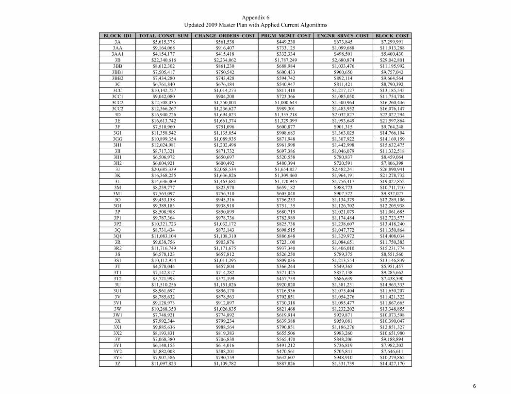
Appendix 6Updated 2009 Master Plan with Applied Current Algorithms
BLOCK_ID1 TOTAL_CONST_SUM CHANGE_ORDERS_COST PRGM_MGMT_COST ENGNR_SRVCS_COST BLOCK_COST3A $5,615,378 $561,538 $449,230 $673,845 $7,299,991
3AA $9,164,068 $916,407 $733,125 $1,099,688 $11,913,2883AA1 $4,154,177 $415,418 $332,334 $498,501 $5,400,430
3B $22,340,616 $2,234,062 $1,787,249 $2,680,874 $29,042,8013BB $8,612,302 $861,230 $688,984 $1,033,476 $11,195,992
3BB1 $7,505,417 $750,542 $600,433 $900,650 $9,757,0423BB2 $7,434,280 $743,428 $594,742 $892,114 $9,664,564
3C $6,761,840 $676,184 $540,947 $811,421 $8,790,3923CC $10,142,727 $1,014,273 $811,418 $1,217,127 $13,185,545
3CC1 $9,042,080 $904,208 $723,366 $1,085,050 $11,754,7043CC2 $12,508,035 $1,250,804 $1,000,643 $1,500,964 $16,260,4463CC2 $12,366,267 $1,236,627 $989,301 $1,483,952 $16,076,147
3D $16,940,226 $1,694,023 $1,355,218 $2,032,827 $22,022,2943E $16,613,742 $1,661,374 $1,329,099 $1,993,649 $21,597,8643F $7,510,960 $751,096 $600,877 $901,315 $9,764,248
3G1 $11,358,542 $1,135,854 $908,683 $1,363,025 $14,766,1043GG $10,899,354 $1,089,935 $871,948 $1,307,922 $14,169,1593H1 $12,024,981 $1,202,498 $961,998 $1,442,998 $15,632,4753II $8,717,321 $871,732 $697,386 $1,046,079 $11,332,518
3II1 $6,506,972 $650,697 $520,558 $780,837 $8,459,0643II2 $6,004,921 $600,492 $480,394 $720,591 $7,806,3983J $20,685,339 $2,068,534 $1,654,827 $2,482,241 $26,890,9413K $16,368,255 $1,636,826 $1,309,460 $1,964,191 $21,278,7323L $14,636,809 $1,463,681 $1,170,945 $1,756,417 $19,027,8523M $8,239,777 $823,978 $659,182 $988,773 $10,711,710
3M1 $7,563,097 $756,310 $605,048 $907,572 $9,832,0273O $9,453,158 $945,316 $756,253 $1,134,379 $12,289,106
3O1 $9,389,183 $938,918 $751,135 $1,126,702 $12,205,9383P $8,508,988 $850,899 $680,719 $1,021,079 $11,061,685
3P1 $9,787,364 $978,736 $782,989 $1,174,484 $12,723,5733P2 $10,321,723 $1,032,172 $825,738 $1,238,607 $13,418,2403Q $8,731,434 $873,143 $698,515 $1,047,772 $11,350,864
3Q1 $11,083,104 $1,108,310 $886,648 $1,329,972 $14,408,0343R $9,038,756 $903,876 $723,100 $1,084,651 $11,750,383
3R2 $11,716,749 $1,171,675 $937,340 $1,406,010 $15,231,7743S $6,578,123 $657,812 $526,250 $789,375 $8,551,560
3S1 $10,112,954 $1,011,295 $809,036 $1,213,554 $13,146,8393T $4,578,044 $457,804 $366,244 $549,365 $5,951,457
3T1 $7,142,817 $714,282 $571,425 $857,138 $9,285,6623T2 $5,721,993 $572,199 $457,759 $686,639 $7,438,5903U $11,510,256 $1,151,026 $920,820 $1,381,231 $14,963,333
3U1 $8,961,697 $896,170 $716,936 $1,075,404 $11,650,2073V $8,785,632 $878,563 $702,851 $1,054,276 $11,421,322
3V1 $9,128,973 $912,897 $730,318 $1,095,477 $11,867,6653W $10,268,350 $1,026,835 $821,468 $1,232,202 $13,348,855
3W1 $7,748,921 $774,892 $619,914 $929,871 $10,073,5983X $7,992,344 $799,234 $639,388 $959,081 $10,390,047
3X1 $9,885,636 $988,564 $790,851 $1,186,276 $12,851,3273X2 $8,193,831 $819,383 $655,506 $983,260 $10,651,9803Y $7,068,380 $706,838 $565,470 $848,206 $9,188,894
3Y1 $6,140,155 $614,016 $491,212 $736,819 $7,982,2023Y2 $5,882,008 $588,201 $470,561 $705,841 $7,646,6113Y3 $7,907,586 $790,759 $632,607 $948,910 $10,279,8623Z $11,097,823 $1,109,782 $887,826 $1,331,739 $14,427,170
6
Appendix 6CIVIL WORK COSTS
BLOCK_ID1 Pub_Notice_Cost Joint_Trench_Cost Non_Joint_Trench_Cost Cust_Trench_Cost Road_Resurf_Cost Streetlights_Cost Curb_Ramp_Cost Permits_Inspections_Cost Tree_Cost SWPPP_Cost Traff_Control_Cost Civil_Subtotal_Cost CIVIL_OAP CIVIL_SUM3A $16,160 $974,805 $162,451 $454,500 $292,442 $339,063 $19,500 $12,120 $6,666 $121,851 $45,000 $2,444,558 $488,912 $2,933,470
3AA $14,600 $1,867,425 $311,206 $586,500 $560,227 $649,539 $61,500 $15,640 $8,602 $233,428 $45,000 $4,353,667 $870,733 $5,224,4003AA1 $16,090 $669,266 $111,533 $328,500 $200,780 $232,788 $0 $8,760 $4,818 $83,658 $45,000 $1,701,193 $340,239 $2,041,432
3B $20,430 $4,867,479 $811,165 $1,294,500 $1,460,244 $1,693,036 $100,500 $34,520 $18,986 $608,435 $45,000 $10,954,295 $2,190,859 $13,145,1543BB $13,030 $1,852,698 $308,752 $496,500 $555,809 $644,417 $46,500 $13,240 $7,282 $231,587 $45,000 $4,214,815 $842,963 $5,057,778
3BB1 $9,480 $1,477,965 $246,303 $519,000 $443,389 $514,075 $48,000 $13,840 $7,612 $184,746 $45,000 $3,509,410 $701,882 $4,211,2923BB2 $14,300 $1,531,960 $255,301 $450,000 $459,588 $532,856 $46,500 $12,000 $6,600 $191,495 $45,000 $3,545,600 $709,120 $4,254,720
3C $6,330 $1,548,081 $257,988 $313,500 $464,424 $538,463 $30,000 $8,360 $4,598 $193,510 $45,000 $3,410,254 $682,051 $4,092,3053CC $7,390 $2,057,472 $342,878 $579,000 $617,242 $715,642 $6,000 $15,440 $8,492 $257,184 $45,000 $4,651,740 $930,348 $5,582,088
3CC1 $7,310 $1,991,687 $331,915 $450,000 $597,506 $692,761 $25,500 $12,000 $6,600 $248,961 $45,000 $4,409,240 $881,848 $5,291,0883CC2 $5,840 $3,275,204 $545,813 $355,500 $982,561 $1,139,201 $6,000 $9,480 $5,214 $409,400 $45,000 $6,779,213 $1,355,843 $8,135,0563CC2 $5,460 $3,275,204 $545,813 $397,500 $982,561 $1,139,201 $7,500 $10,600 $5,830 $409,400 $45,000 $6,824,069 $1,364,814 $8,188,883
3D $10,510 $3,610,330 $601,662 $1,068,000 $1,083,099 $1,255,767 $63,000 $28,480 $15,664 $451,291 $45,000 $8,232,803 $1,646,561 $9,879,3643E $10,300 $3,627,982 $604,603 $969,000 $1,088,395 $1,261,907 $84,000 $25,840 $14,212 $453,498 $45,000 $8,184,737 $1,636,947 $9,821,6843F $8,800 $1,644,018 $273,976 $406,500 $493,205 $571,832 $34,500 $10,840 $5,962 $205,502 $45,000 $3,700,135 $740,027 $4,440,162
3G1 $9,800 $2,462,034 $410,298 $652,500 $738,610 $856,360 $69,000 $17,400 $9,570 $307,754 $45,000 $5,578,326 $1,115,665 $6,693,9913GG $36,240 $2,176,935 $362,786 $633,000 $653,081 $757,195 $43,500 $16,880 $9,284 $272,117 $45,000 $5,006,018 $1,001,204 $6,007,2223H1 $14,240 $2,463,451 $410,534 $801,000 $739,035 $856,852 $67,500 $21,360 $11,748 $307,931 $45,000 $5,738,651 $1,147,730 $6,886,3813II $17,020 $1,841,786 $306,934 $525,000 $552,536 $640,621 $69,000 $14,000 $7,700 $230,223 $45,000 $4,249,820 $849,964 $5,099,784
3II1 $17,600 $1,184,383 $197,377 $493,500 $355,315 $411,959 $30,000 $13,160 $7,238 $148,048 $45,000 $2,903,580 $580,716 $3,484,2963II2 $18,320 $1,031,978 $171,979 $483,000 $309,593 $358,949 $19,500 $12,880 $7,084 $128,997 $45,000 $2,587,280 $517,456 $3,104,7363J $20,430 $4,435,189 $739,124 $1,272,000 $1,330,557 $1,542,674 $148,500 $33,920 $18,656 $554,399 $45,000 $10,140,449 $2,028,090 $12,168,5393K $15,500 $3,604,521 $600,693 $922,500 $1,081,356 $1,253,746 $142,500 $24,600 $13,530 $450,565 $45,000 $8,154,511 $1,630,902 $9,785,4133L $13,210 $3,210,993 $535,112 $898,500 $963,298 $1,116,867 $81,000 $23,960 $13,178 $401,374 $45,000 $7,302,492 $1,460,498 $8,762,9903M $26,790 $1,512,779 $252,105 $618,000 $453,834 $526,184 $33,000 $16,480 $9,064 $189,097 $45,000 $3,682,333 $736,467 $4,418,8003M1 $22,310 $1,314,142 $219,002 $622,500 $394,243 $457,093 $15,000 $16,600 $9,130 $164,268 $45,000 $3,279,288 $655,858 $3,935,1463O $19,640 $1,973,819 $328,937 $589,500 $592,146 $686,546 $28,500 $15,720 $8,646 $246,727 $45,000 $4,535,181 $907,036 $5,442,217
3O1 $25,120 $1,761,377 $293,533 $730,500 $528,413 $612,653 $39,000 $19,480 $10,714 $220,172 $45,000 $4,285,962 $857,192 $5,143,1543P $16,330 $1,723,964 $287,299 $535,500 $517,189 $599,640 $57,000 $14,280 $7,854 $215,495 $45,000 $4,019,551 $803,910 $4,823,4613P1 $10,060 $2,114,468 $352,376 $606,000 $634,340 $735,467 $54,000 $16,160 $8,888 $264,309 $45,000 $4,841,068 $968,214 $5,809,2823P2 $14,210 $2,058,513 $343,051 $757,500 $617,554 $716,004 $39,000 $20,200 $11,110 $257,314 $45,000 $4,879,456 $975,891 $5,855,3473Q $18,750 $1,731,544 $288,562 $595,500 $519,463 $602,276 $40,500 $15,880 $8,734 $216,443 $45,000 $4,082,652 $816,530 $4,899,182
3Q1 $9,810 $2,279,164 $379,823 $753,000 $683,749 $792,753 $63,000 $20,080 $11,044 $284,896 $45,000 $5,322,319 $1,064,464 $6,386,7833R $34,920 $1,825,230 $304,175 $523,500 $547,569 $634,863 $42,000 $13,960 $7,678 $228,154 $45,000 $4,207,049 $841,410 $5,048,459
3R2 $21,260 $2,730,258 $454,998 $511,500 $819,078 $949,655 $57,000 $13,640 $7,502 $341,282 $45,000 $5,951,173 $1,190,235 $7,141,4083S $14,770 $1,332,970 $222,139 $330,000 $399,891 $463,642 $37,500 $8,800 $4,840 $166,621 $45,000 $3,026,173 $605,235 $3,631,4083S1 $14,610 $2,274,646 $379,070 $489,000 $682,394 $791,181 $67,500 $13,040 $7,172 $284,331 $45,000 $5,047,944 $1,009,589 $6,057,5333T $12,750 $825,647 $137,594 $280,500 $247,694 $287,182 $15,000 $7,480 $4,114 $103,206 $45,000 $1,966,167 $393,233 $2,359,400
3T1 $12,710 $1,611,755 $268,599 $315,000 $483,526 $560,610 $54,000 $8,400 $4,620 $201,469 $45,000 $3,565,689 $713,138 $4,278,8273T2 $13,600 $1,148,888 $191,462 $309,000 $344,667 $399,613 $21,000 $8,240 $4,532 $143,611 $45,000 $2,629,613 $525,923 $3,155,5363U $15,240 $2,750,140 $458,311 $432,000 $825,042 $956,570 $45,000 $11,520 $6,336 $343,767 $45,000 $5,888,926 $1,177,785 $7,066,711
3U1 $8,190 $1,927,544 $321,225 $493,500 $578,263 $670,450 $52,500 $13,160 $7,238 $240,943 $45,000 $4,358,013 $871,603 $5,229,6163V $23,300 $1,571,633 $261,913 $721,500 $471,490 $546,655 $18,000 $19,240 $10,582 $196,454 $45,000 $3,885,767 $777,153 $4,662,9203V1 $15,660 $1,711,428 $285,209 $720,000 $513,428 $595,279 $48,000 $19,200 $10,560 $213,928 $45,000 $4,177,692 $835,538 $5,013,2303W $17,110 $2,159,333 $359,853 $592,500 $647,800 $751,072 $57,000 $15,800 $8,690 $269,917 $45,000 $4,924,075 $984,815 $5,908,8903W1 $21,780 $1,575,948 $262,632 $457,500 $472,784 $548,156 $42,000 $12,200 $6,710 $196,993 $45,000 $3,641,703 $728,341 $4,370,0443X $14,000 $1,614,886 $269,121 $472,500 $484,466 $561,700 $31,500 $12,600 $6,930 $201,861 $45,000 $3,714,564 $742,913 $4,457,477
3X1 $25,300 $2,004,583 $334,064 $568,500 $601,375 $697,246 $52,500 $15,160 $8,338 $250,573 $45,000 $4,602,639 $920,528 $5,523,1673X2 $20,670 $1,649,753 $274,931 $481,500 $494,926 $573,827 $42,000 $12,840 $7,062 $206,219 $45,000 $3,808,728 $761,746 $4,570,4743Y $11,950 $1,394,216 $232,346 $472,500 $418,265 $484,945 $34,500 $12,600 $6,930 $174,277 $45,000 $3,287,529 $657,506 $3,945,035
3Y1 $19,450 $1,111,493 $185,230 $475,500 $333,448 $386,606 $24,000 $12,680 $6,974 $138,937 $45,000 $2,739,318 $547,864 $3,287,1823Y2 $25,310 $1,131,158 $188,507 $346,500 $339,347 $393,446 $22,500 $9,240 $5,082 $141,395 $45,000 $2,647,485 $529,497 $3,176,9823Y3 $19,400 $1,666,966 $277,800 $376,500 $500,090 $579,814 $51,000 $10,040 $5,522 $208,371 $45,000 $3,740,503 $748,101 $4,488,6043Z $28,700 $2,216,739 $369,420 $688,500 $665,022 $771,040 $54,000 $18,360 $10,098 $277,092 $45,000 $5,143,971 $1,028,794 $6,172,765
Appendix 6SPECIAL ELECTTRICAL WORK COSTS
BLOCK_ID1 XFMR_COST PRIM_BACKBONE_CABLING_COST SEC_BACKBONE_CABLING_COST CUST_CABLE_COST CUT_OVER_COST BOUND_CIRC_FEEDER_COST SUBSTATION_COST SPCL_E_Subtotal SPCL_E_OAP SPECIAL_ELEC_SERV_TOTAL3A $525,000 $105,279 $187,163 $276,125 $151,500 $75,000 $0 $1,320,067 $264,013 $1,584,080
3AA $682,500 $201,682 $358,546 $480,660 $195,500 $75,000 $0 $1,993,888 $398,778 $2,392,6663AA1 $525,000 $72,281 $128,499 $192,375 $109,500 $75,000 $0 $1,102,655 $220,531 $1,323,186
3B $1,435,000 $525,688 $934,556 $1,213,031 $431,500 $75,000 $0 $4,614,775 $922,955 $5,537,7303BB $525,000 $200,091 $355,718 $462,355 $165,500 $75,000 $0 $1,783,664 $356,733 $2,140,3973BB1 $525,000 $159,620 $283,769 $389,735 $173,000 $75,000 $0 $1,606,124 $321,225 $1,927,3493BB2 $560,000 $165,452 $294,136 $389,020 $150,000 $75,000 $0 $1,633,608 $326,722 $1,960,330
3C $350,000 $167,193 $297,232 $369,104 $104,500 $75,000 $0 $1,363,029 $272,606 $1,635,6353CC $927,500 $222,207 $395,035 $518,154 $193,000 $75,000 $0 $2,330,896 $466,179 $2,797,0753CC1 $647,500 $215,102 $382,404 $482,804 $150,000 $75,000 $0 $1,952,810 $390,562 $2,343,3723CC2 $647,500 $353,722 $628,839 $728,577 $118,500 $75,000 $0 $2,552,138 $510,428 $3,062,5663CC2 $542,500 $353,722 $628,839 $735,717 $132,500 $75,000 $0 $2,468,278 $493,656 $2,961,934
3D $1,102,500 $389,916 $693,183 $918,067 $356,000 $75,000 $0 $3,534,666 $706,933 $4,241,5993E $1,067,500 $391,822 $696,573 $904,838 $323,000 $75,000 $0 $3,458,733 $691,747 $4,150,4803F $437,500 $177,554 $315,651 $404,485 $135,500 $75,000 $0 $1,545,690 $309,138 $1,854,828
3G1 $752,500 $265,900 $472,710 $613,180 $217,500 $75,000 $0 $2,396,790 $479,358 $2,876,1483GG $1,137,500 $235,109 $417,972 $551,705 $211,000 $75,000 $0 $2,628,286 $525,657 $3,153,9433H1 $910,000 $266,053 $472,983 $638,714 $267,000 $75,000 $0 $2,629,750 $525,950 $3,155,7003II $577,500 $198,913 $353,623 $464,974 $175,000 $75,000 $0 $1,845,010 $369,002 $2,214,0123II1 $560,000 $127,913 $227,401 $325,509 $164,500 $75,000 $0 $1,480,323 $296,065 $1,776,3883II2 $560,000 $111,454 $198,140 $292,633 $161,000 $75,000 $0 $1,398,227 $279,645 $1,677,8723J $1,435,000 $479,000 $851,556 $1,121,019 $424,000 $75,000 $0 $4,385,575 $877,115 $5,262,6903K $1,120,000 $389,288 $692,068 $892,147 $307,500 $75,000 $0 $3,476,003 $695,201 $4,171,2043L $840,000 $346,787 $616,511 $807,788 $299,500 $75,000 $0 $2,985,586 $597,117 $3,582,7033M $770,000 $163,380 $290,454 $413,667 $206,000 $75,000 $0 $1,918,501 $383,700 $2,302,201
3M1 $752,500 $141,927 $252,315 $373,910 $207,500 $75,000 $0 $1,803,152 $360,630 $2,163,7823O $647,500 $213,172 $378,973 $502,874 $196,500 $75,000 $0 $2,014,019 $402,804 $2,416,823
3O1 $735,000 $190,229 $338,184 $483,506 $243,500 $75,000 $0 $2,065,419 $413,084 $2,478,5033P $717,500 $186,188 $331,001 $442,724 $178,500 $75,000 $0 $1,930,913 $386,183 $2,317,096
3P1 $455,000 $228,363 $405,978 $534,372 $202,000 $75,000 $0 $1,900,713 $380,143 $2,280,8563P2 $682,500 $222,319 $395,234 $548,712 $252,500 $75,000 $0 $2,176,265 $435,253 $2,611,5183Q $647,500 $187,007 $332,456 $454,470 $198,500 $75,000 $0 $1,894,933 $378,987 $2,273,920
3Q1 $630,000 $246,150 $437,600 $592,959 $251,000 $75,000 $0 $2,232,709 $446,542 $2,679,2513R $875,000 $197,125 $350,444 $461,342 $174,500 $75,000 $0 $2,133,411 $426,682 $2,560,0933R2 $787,500 $294,868 $524,210 $643,928 $170,500 $75,000 $0 $2,496,006 $499,201 $2,995,2073S $717,500 $143,961 $255,930 $328,026 $110,000 $75,000 $0 $1,630,417 $326,083 $1,956,500
3S1 $717,500 $245,662 $436,732 $547,158 $163,000 $75,000 $0 $2,185,052 $437,010 $2,622,0623T $560,000 $89,170 $158,524 $216,117 $93,500 $75,000 $0 $1,192,311 $238,462 $1,430,7733T1 $560,000 $174,070 $309,457 $382,348 $105,000 $75,000 $0 $1,605,875 $321,175 $1,927,0503T2 $612,500 $124,080 $220,587 $286,903 $103,000 $75,000 $0 $1,422,070 $284,414 $1,706,4843U $840,000 $297,015 $528,027 $634,468 $144,000 $75,000 $0 $2,518,510 $503,702 $3,022,212
3U1 $630,000 $208,175 $370,088 $477,114 $164,500 $75,000 $0 $1,924,877 $384,975 $2,309,8523V $770,000 $169,736 $301,754 $443,268 $240,500 $75,000 $0 $2,000,258 $400,052 $2,400,310
3V1 $665,000 $184,834 $328,594 $471,531 $240,000 $75,000 $0 $1,964,959 $392,992 $2,357,9513W $822,500 $233,208 $414,592 $541,229 $197,500 $75,000 $0 $2,284,029 $456,806 $2,740,835
3W1 $665,000 $170,202 $302,582 $399,268 $152,500 $75,000 $0 $1,764,552 $352,910 $2,117,4623X $665,000 $174,408 $310,058 $409,762 $157,500 $75,000 $100,000 $1,891,728 $378,346 $2,270,074
3X1 $962,500 $216,495 $384,880 $505,580 $189,500 $75,000 $0 $2,333,955 $466,791 $2,800,7463X2 $752,500 $178,173 $316,753 $418,405 $160,500 $75,000 $0 $1,901,331 $380,266 $2,281,5973Y $507,500 $150,575 $267,689 $364,745 $157,500 $75,000 $0 $1,523,009 $304,602 $1,827,6113Y1 $542,500 $120,041 $213,407 $307,580 $158,500 $75,000 $0 $1,417,028 $283,406 $1,700,4343Y2 $647,500 $122,165 $217,182 $289,661 $115,500 $75,000 $0 $1,467,008 $293,402 $1,760,4103Y3 $700,000 $180,032 $320,057 $404,066 $125,500 $75,000 $100,000 $1,904,655 $380,931 $2,285,5863Z $1,050,000 $239,408 $425,614 $569,260 $229,500 $75,000 $0 $2,588,782 $517,756 $3,106,538
3
Appendix 6BASIC ELECTRICAL WORK COSTS
BLOCK_ID1 PANEL_COST OH_CABLE_RMV_COST OH_CUST_CABLE_RMV_COST STREET_POWER_POLE_RMVL_COST ALLEY_POLE_COST BACKLOT_POLE_COST BASIC_E_Subtotal BASIC_E_OAP BASIC_ELEC_SERV_TOTAL3A $606,000 $29,668 $79,689 $17,500 $110,000 $72,000 $914,857 $182,971 $1,097,828
3AA $782,000 $56,835 $102,833 $87,500 $160,000 $100,000 $1,289,168 $257,834 $1,547,0023AA1 $438,000 $20,369 $57,597 $14,000 $120,000 $8,000 $657,966 $131,593 $789,559
3B $1,726,000 $148,141 $226,969 $273,000 $182,000 $492,000 $3,048,110 $609,622 $3,657,7323BB $662,000 $56,386 $87,053 $91,000 $98,000 $184,000 $1,178,439 $235,688 $1,414,1273BB1 $692,000 $44,982 $90,998 $91,000 $88,000 $132,000 $1,138,980 $227,796 $1,366,7763BB2 $600,000 $46,625 $78,900 $52,500 $154,000 $84,000 $1,016,025 $203,205 $1,219,230
3C $418,000 $47,116 $54,967 $101,500 $0 $240,000 $861,583 $172,317 $1,033,9003CC $772,000 $62,619 $101,518 $45,500 $8,000 $480,000 $1,469,637 $293,927 $1,763,5643CC1 $600,000 $60,617 $78,900 $59,500 $42,000 $332,000 $1,173,017 $234,603 $1,407,6203CC2 $474,000 $99,680 $62,331 $28,000 $0 $428,000 $1,092,011 $218,402 $1,310,4133CC2 $530,000 $99,680 $69,695 $31,500 $18,000 $264,000 $1,012,875 $202,575 $1,215,450
3D $1,424,000 $109,880 $187,256 $320,250 $16,000 $292,000 $2,349,386 $469,877 $2,819,2633E $1,292,000 $110,417 $169,898 $259,000 $14,000 $356,000 $2,201,315 $440,263 $2,641,5783F $542,000 $50,035 $71,273 $140,000 $18,000 $192,000 $1,013,308 $202,662 $1,215,970
3G1 $870,000 $74,931 $114,405 $133,000 $170,000 $128,000 $1,490,336 $298,067 $1,788,4033GG $844,000 $66,255 $110,986 $61,250 $282,000 $84,000 $1,448,491 $289,698 $1,738,1893H1 $1,068,000 $74,975 $140,442 $161,000 $156,000 $52,000 $1,652,417 $330,483 $1,982,9003II $700,000 $56,054 $92,050 $73,500 $164,000 $84,000 $1,169,604 $233,921 $1,403,5253II1 $658,000 $36,046 $86,527 $42,000 $104,000 $112,000 $1,038,573 $207,715 $1,246,2883II2 $644,000 $31,408 $84,686 $10,500 $172,000 $76,000 $1,018,594 $203,719 $1,222,3133J $1,696,000 $134,984 $223,024 $337,750 $188,000 $132,000 $2,711,758 $542,352 $3,254,1103K $1,230,000 $109,703 $161,745 $166,250 $266,000 $76,000 $2,009,698 $401,940 $2,411,6383L $1,198,000 $97,726 $157,537 $98,000 $254,000 $104,000 $1,909,263 $381,853 $2,291,1163M $824,000 $46,041 $108,356 $33,250 $234,000 $20,000 $1,265,647 $253,129 $1,518,776
3M1 $830,000 $39,996 $109,145 $7,000 $194,000 $40,000 $1,220,141 $244,028 $1,464,1693O $786,000 $60,073 $103,359 $63,000 $200,000 $116,000 $1,328,432 $265,686 $1,594,1183O1 $974,000 $53,607 $128,081 $33,250 $200,000 $84,000 $1,472,938 $294,588 $1,767,5263P $714,000 $52,468 $93,891 $70,000 $190,000 $20,000 $1,140,359 $228,072 $1,368,4313P1 $808,000 $64,353 $106,252 $57,750 $118,000 $260,000 $1,414,355 $282,871 $1,697,2263P2 $1,010,000 $62,650 $132,815 $68,250 $208,000 $64,000 $1,545,715 $309,143 $1,854,8583Q $794,000 $52,699 $104,411 $59,500 $116,000 $172,000 $1,298,610 $259,722 $1,558,3323Q1 $1,004,000 $69,366 $132,026 $115,500 $168,000 $192,000 $1,680,892 $336,178 $2,017,0703R $698,000 $55,550 $91,787 $24,500 $214,000 $108,000 $1,191,837 $238,367 $1,430,2043R2 $682,000 $83,095 $89,683 $182,000 $92,000 $188,000 $1,316,778 $263,356 $1,580,1343S $440,000 $40,569 $57,860 $50,750 $132,000 $104,000 $825,179 $165,036 $990,2153S1 $652,000 $69,228 $85,738 $129,500 $138,000 $120,000 $1,194,466 $238,893 $1,433,3593T $374,000 $25,128 $49,181 $68,250 $124,000 $16,000 $656,559 $131,312 $787,8713T1 $420,000 $49,053 $55,230 $122,500 $94,000 $40,000 $780,783 $156,157 $936,9403T2 $412,000 $34,966 $54,178 $59,500 $116,000 $40,000 $716,644 $143,329 $859,9733U $576,000 $83,700 $75,744 $175,000 $86,000 $188,000 $1,184,444 $236,889 $1,421,3333U1 $658,000 $58,664 $86,527 $126,000 $104,000 $152,000 $1,185,191 $237,038 $1,422,2293V $962,000 $47,832 $126,503 $21,000 $222,000 $56,000 $1,435,335 $287,067 $1,722,4023V1 $960,000 $52,087 $126,240 $66,500 $152,000 $108,000 $1,464,827 $292,965 $1,757,7923W $790,000 $65,719 $103,885 $131,250 $130,000 $128,000 $1,348,854 $269,771 $1,618,6253W1 $610,000 $47,964 $80,215 $49,000 $172,000 $92,000 $1,051,179 $210,236 $1,261,4153X $630,000 $49,149 $82,845 $98,000 $106,000 $88,000 $1,053,994 $210,799 $1,264,7933X1 $758,000 $61,009 $99,677 $36,750 $242,000 $104,000 $1,301,436 $260,287 $1,561,7233X2 $642,000 $50,210 $84,423 $31,500 $194,000 $116,000 $1,118,133 $223,627 $1,341,7603Y $630,000 $42,433 $82,845 $66,500 $90,000 $168,000 $1,079,778 $215,956 $1,295,7343Y1 $634,000 $33,828 $83,371 $19,250 $114,000 $76,000 $960,449 $192,090 $1,152,5393Y2 $462,000 $34,427 $60,753 $14,000 $148,000 $68,000 $787,180 $157,436 $944,6163Y3 $502,000 $50,734 $66,013 $43,750 $210,000 $72,000 $944,497 $188,899 $1,133,3963Z $918,000 $67,466 $120,717 $47,250 $242,000 $120,000 $1,515,433 $303,087 $1,818,520
3

UUP MASTER PLAN UPDATE – FACTORS AND METHOD
APPENDIX 6 DISTRICT 4
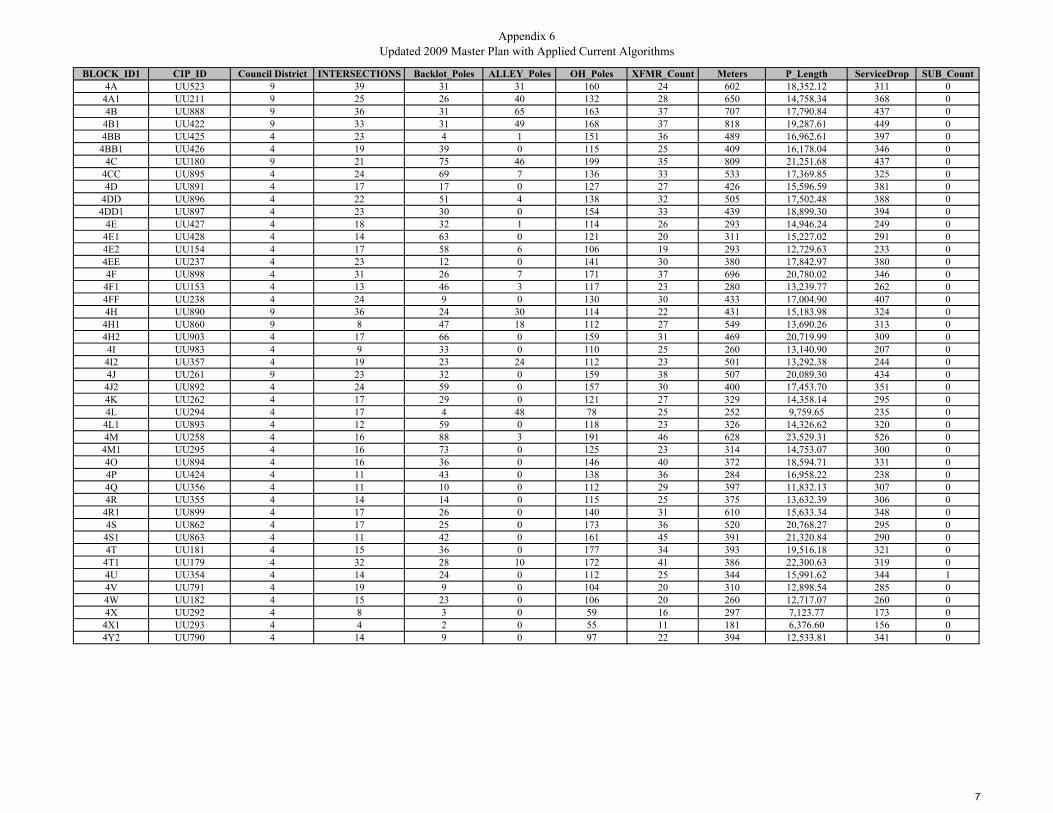
Appendix 6Updated 2009 Master Plan with Applied Current Algorithms
BLOCK_ID1 CIP_ID Council District INTERSECTIONS Backlot_Poles ALLEY_Poles OH_Poles XFMR_Count Meters P_Length ServiceDrop SUB_Count4A UU523 9 39 31 31 160 24 602 18,352.12 311 0
4A1 UU211 9 25 26 40 132 28 650 14,758.34 368 04B UU888 9 36 31 65 163 37 707 17,790.84 437 0
4B1 UU422 9 33 31 49 168 37 818 19,287.61 449 04BB UU425 4 23 4 1 151 36 489 16,962.61 397 0
4BB1 UU426 4 19 39 0 115 25 409 16,178.04 346 04C UU180 9 21 75 46 199 35 809 21,251.68 437 0
4CC UU895 4 24 69 7 136 33 533 17,369.85 325 04D UU891 4 17 17 0 127 27 426 15,596.59 381 0
4DD UU896 4 22 51 4 138 32 505 17,502.48 388 04DD1 UU897 4 23 30 0 154 33 439 18,899.30 394 0
4E UU427 4 18 32 1 114 26 293 14,946.24 249 04E1 UU428 4 14 63 0 121 20 311 15,227.02 291 04E2 UU154 4 17 58 6 106 19 293 12,729.63 233 04EE UU237 4 23 12 0 141 30 380 17,842.97 380 04F UU898 4 31 26 7 171 37 696 20,780.02 346 0
4F1 UU153 4 13 46 3 117 23 280 13,239.77 262 04FF UU238 4 24 9 0 130 30 433 17,004.90 407 04H UU890 9 36 24 30 114 22 431 15,183.98 324 0
4H1 UU860 9 8 47 18 112 27 549 13,690.26 313 04H2 UU903 4 17 66 0 159 31 469 20,719.99 309 04I UU983 4 9 33 0 110 25 260 13,140.90 207 0
4I2 UU357 4 19 23 24 112 23 501 13,292.38 244 04J UU261 9 23 32 0 159 38 507 20,089.30 434 0
4J2 UU892 4 24 59 0 157 30 400 17,453.70 351 04K UU262 4 17 29 0 121 27 329 14,358.14 295 04L UU294 4 17 4 48 78 25 252 9,759.65 235 0
4L1 UU893 4 12 59 0 118 23 326 14,326.62 320 04M UU258 4 16 88 3 191 46 628 23,529.31 526 0
4M1 UU295 4 16 73 0 125 23 314 14,753.07 300 04O UU894 4 16 36 0 146 40 372 18,594.71 331 04P UU424 4 11 43 0 138 36 284 16,958.22 238 04Q UU356 4 11 10 0 112 29 397 11,832.13 307 04R UU355 4 14 14 0 115 25 375 13,632.39 306 0
4R1 UU899 4 17 26 0 140 31 610 15,633.34 348 04S UU862 4 17 25 0 173 36 520 20,768.27 295 0
4S1 UU863 4 11 42 0 161 45 391 21,320.84 290 04T UU181 4 15 36 0 177 34 393 19,516.18 321 0
4T1 UU179 4 32 28 10 172 41 386 22,300.63 319 04U UU354 4 14 24 0 112 25 344 15,991.62 344 14V UU791 4 19 9 0 104 20 310 12,898.54 285 04W UU182 4 15 23 0 106 20 260 12,717.07 260 04X UU292 4 8 3 0 59 16 297 7,123.77 173 0
4X1 UU293 4 4 2 0 55 11 181 6,376.60 156 04Y2 UU790 4 14 9 0 97 22 394 12,533.81 341 0
7
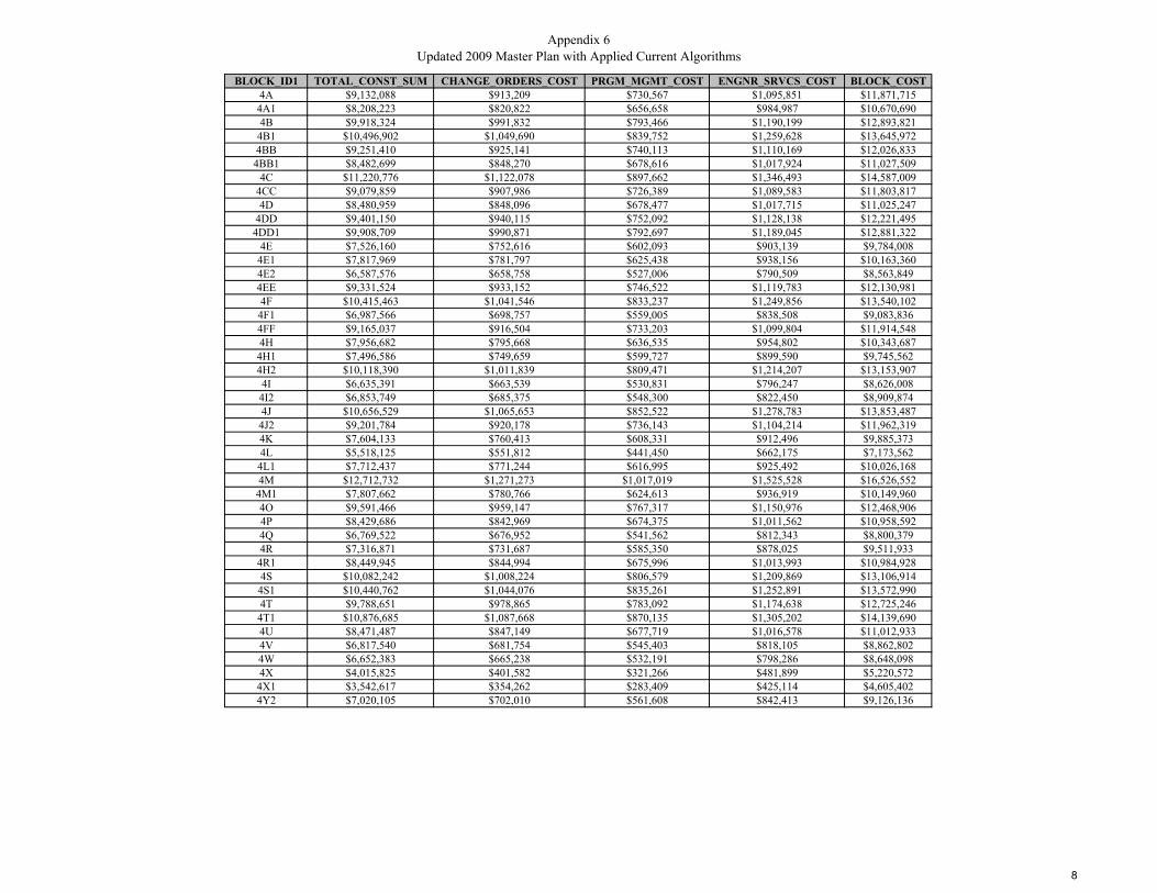
Appendix 6Updated 2009 Master Plan with Applied Current Algorithms
BLOCK_ID1 TOTAL_CONST_SUM CHANGE_ORDERS_COST PRGM_MGMT_COST ENGNR_SRVCS_COST BLOCK_COST4A $9,132,088 $913,209 $730,567 $1,095,851 $11,871,715
4A1 $8,208,223 $820,822 $656,658 $984,987 $10,670,6904B $9,918,324 $991,832 $793,466 $1,190,199 $12,893,821
4B1 $10,496,902 $1,049,690 $839,752 $1,259,628 $13,645,9724BB $9,251,410 $925,141 $740,113 $1,110,169 $12,026,833
4BB1 $8,482,699 $848,270 $678,616 $1,017,924 $11,027,5094C $11,220,776 $1,122,078 $897,662 $1,346,493 $14,587,009
4CC $9,079,859 $907,986 $726,389 $1,089,583 $11,803,8174D $8,480,959 $848,096 $678,477 $1,017,715 $11,025,247
4DD $9,401,150 $940,115 $752,092 $1,128,138 $12,221,4954DD1 $9,908,709 $990,871 $792,697 $1,189,045 $12,881,322
4E $7,526,160 $752,616 $602,093 $903,139 $9,784,0084E1 $7,817,969 $781,797 $625,438 $938,156 $10,163,3604E2 $6,587,576 $658,758 $527,006 $790,509 $8,563,8494EE $9,331,524 $933,152 $746,522 $1,119,783 $12,130,9814F $10,415,463 $1,041,546 $833,237 $1,249,856 $13,540,102
4F1 $6,987,566 $698,757 $559,005 $838,508 $9,083,8364FF $9,165,037 $916,504 $733,203 $1,099,804 $11,914,5484H $7,956,682 $795,668 $636,535 $954,802 $10,343,687
4H1 $7,496,586 $749,659 $599,727 $899,590 $9,745,5624H2 $10,118,390 $1,011,839 $809,471 $1,214,207 $13,153,9074I $6,635,391 $663,539 $530,831 $796,247 $8,626,008
4I2 $6,853,749 $685,375 $548,300 $822,450 $8,909,8744J $10,656,529 $1,065,653 $852,522 $1,278,783 $13,853,487
4J2 $9,201,784 $920,178 $736,143 $1,104,214 $11,962,3194K $7,604,133 $760,413 $608,331 $912,496 $9,885,3734L $5,518,125 $551,812 $441,450 $662,175 $7,173,562
4L1 $7,712,437 $771,244 $616,995 $925,492 $10,026,1684M $12,712,732 $1,271,273 $1,017,019 $1,525,528 $16,526,552
4M1 $7,807,662 $780,766 $624,613 $936,919 $10,149,9604O $9,591,466 $959,147 $767,317 $1,150,976 $12,468,9064P $8,429,686 $842,969 $674,375 $1,011,562 $10,958,5924Q $6,769,522 $676,952 $541,562 $812,343 $8,800,3794R $7,316,871 $731,687 $585,350 $878,025 $9,511,933
4R1 $8,449,945 $844,994 $675,996 $1,013,993 $10,984,9284S $10,082,242 $1,008,224 $806,579 $1,209,869 $13,106,914
4S1 $10,440,762 $1,044,076 $835,261 $1,252,891 $13,572,9904T $9,788,651 $978,865 $783,092 $1,174,638 $12,725,246
4T1 $10,876,685 $1,087,668 $870,135 $1,305,202 $14,139,6904U $8,471,487 $847,149 $677,719 $1,016,578 $11,012,9334V $6,817,540 $681,754 $545,403 $818,105 $8,862,8024W $6,652,383 $665,238 $532,191 $798,286 $8,648,0984X $4,015,825 $401,582 $321,266 $481,899 $5,220,572
4X1 $3,542,617 $354,262 $283,409 $425,114 $4,605,4024Y2 $7,020,105 $702,010 $561,608 $842,413 $9,126,136
8
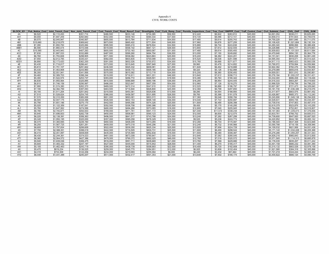
Appendix 6CIVIL WORK COSTS
BLOCK_ID1 Pub_Notice_Cost Joint_Trench_Cost Non_Joint_Trench_Cost Cust_Trench_Cost Road_Resurf_Cost Streetlights_Cost Curb_Ramp_Cost Permits_Inspections_Cost Tree_Cost SWPPP_Cost Traff_Control_Cost Civil_Subtotal_Cost CIVIL_OAP CIVIL_SUM4A $8,520 $2,110,493 $351,714 $466,500 $633,148 $734,085 $58,500 $12,440 $6,842 $263,812 $45,000 $4,691,054 $938,211 $5,629,2654A1 $9,000 $1,697,209 $282,840 $552,000 $509,163 $590,334 $37,500 $14,720 $8,096 $212,151 $45,000 $3,958,013 $791,603 $4,749,6164B $9,570 $2,045,947 $340,957 $655,500 $613,784 $711,634 $54,000 $17,480 $9,614 $255,743 $45,000 $4,759,229 $951,846 $5,711,0754B1 $10,680 $2,218,075 $369,642 $673,500 $665,422 $771,504 $49,500 $17,960 $9,878 $277,259 $45,000 $5,108,420 $1,021,684 $6,130,1044BB $7,390 $1,950,700 $325,084 $595,500 $585,210 $678,504 $34,500 $15,880 $8,734 $243,838 $45,000 $4,490,340 $898,068 $5,388,408
4BB1 $6,590 $1,860,474 $310,048 $519,000 $558,142 $647,121 $28,500 $13,840 $7,612 $232,559 $45,000 $4,228,886 $845,777 $5,074,6634C $10,590 $2,443,943 $407,283 $655,500 $733,183 $850,067 $31,500 $17,480 $9,614 $305,493 $45,000 $5,509,653 $1,101,931 $6,611,584
4CC $7,830 $1,997,533 $332,889 $487,500 $599,260 $694,794 $36,000 $13,000 $7,150 $249,692 $45,000 $4,470,648 $894,130 $5,364,7784D $6,760 $1,793,608 $298,905 $571,500 $538,082 $623,863 $25,500 $15,240 $8,382 $224,201 $45,000 $4,151,041 $830,208 $4,981,249
4DD $7,550 $2,012,785 $335,431 $582,000 $603,835 $700,099 $33,000 $15,520 $8,536 $251,598 $45,000 $4,595,354 $919,071 $5,514,4254DD1 $6,890 $2,173,420 $362,200 $591,000 $652,026 $755,972 $34,500 $15,760 $8,668 $271,677 $45,000 $4,917,113 $983,423 $5,900,536
4E $5,430 $1,718,817 $286,441 $373,500 $515,645 $597,849 $27,000 $9,960 $5,478 $214,852 $45,000 $3,799,972 $759,994 $4,559,9664E1 $5,610 $1,751,107 $291,822 $436,500 $525,332 $609,081 $21,000 $11,640 $6,402 $218,888 $45,000 $3,922,382 $784,476 $4,706,8584E2 $5,430 $1,463,908 $243,960 $349,500 $439,172 $509,185 $25,500 $9,320 $5,126 $182,988 $45,000 $3,279,089 $655,818 $3,934,9074EE $6,300 $2,051,941 $341,956 $570,000 $615,582 $713,719 $34,500 $15,200 $8,360 $256,493 $45,000 $4,659,051 $931,810 $5,590,8614F $9,460 $2,389,703 $398,244 $519,000 $716,911 $831,201 $46,500 $13,840 $7,612 $298,713 $45,000 $5,276,184 $1,055,237 $6,331,421
4F1 $5,300 $1,522,574 $253,737 $393,000 $456,772 $529,591 $19,500 $10,480 $5,764 $190,322 $45,000 $3,432,040 $686,408 $4,118,4484FF $6,830 $1,955,564 $325,895 $610,500 $586,669 $680,196 $36,000 $16,280 $8,954 $244,445 $45,000 $4,516,333 $903,267 $5,419,6004H $6,810 $1,746,158 $290,997 $486,000 $523,847 $607,359 $54,000 $12,960 $7,128 $218,270 $45,000 $3,998,529 $799,706 $4,798,235
4H1 $7,990 $1,574,380 $262,370 $469,500 $472,314 $547,610 $12,000 $12,520 $6,886 $196,797 $45,000 $3,607,367 $721,473 $4,328,8404H2 $7,190 $2,382,799 $397,093 $463,500 $714,840 $828,800 $25,500 $12,360 $6,798 $297,850 $45,000 $5,181,730 $1,036,346 $6,218,0764I $5,100 $1,511,204 $251,842 $310,500 $453,361 $525,636 $13,500 $8,280 $4,554 $188,900 $45,000 $3,317,877 $663,575 $3,981,452
4I2 $7,510 $1,528,624 $254,745 $366,000 $458,587 $531,695 $28,500 $9,760 $5,368 $191,078 $45,000 $3,426,867 $685,373 $4,112,2404J $7,570 $2,310,269 $385,006 $651,000 $693,081 $803,572 $34,500 $17,360 $9,548 $288,784 $45,000 $5,245,690 $1,049,138 $6,294,828
4J2 $6,500 $2,007,175 $334,496 $526,500 $602,153 $698,148 $36,000 $14,040 $7,722 $250,897 $45,000 $4,528,631 $905,726 $5,434,3574K $5,790 $1,651,186 $275,170 $442,500 $495,356 $574,326 $25,500 $11,800 $6,490 $206,398 $45,000 $3,739,516 $747,903 $4,487,4194L $5,020 $1,122,359 $187,041 $352,500 $336,708 $390,386 $25,500 $9,400 $5,170 $140,295 $45,000 $2,619,379 $523,876 $3,143,2554L1 $5,760 $1,647,562 $274,566 $480,000 $494,268 $573,065 $18,000 $12,800 $7,040 $205,945 $45,000 $3,764,006 $752,801 $4,516,8074M $8,780 $2,705,871 $450,933 $789,000 $811,761 $941,172 $24,000 $21,040 $11,572 $338,234 $45,000 $6,147,363 $1,229,473 $7,376,8364M1 $5,640 $1,696,603 $282,739 $450,000 $508,981 $590,123 $24,000 $12,000 $6,600 $212,075 $45,000 $3,833,761 $766,752 $4,600,5134O $6,220 $2,138,391 $356,363 $496,500 $641,517 $743,788 $24,000 $13,240 $7,282 $267,299 $45,000 $4,739,600 $947,920 $5,687,5204P $5,340 $1,950,195 $325,000 $357,000 $585,058 $678,329 $16,500 $9,520 $5,236 $243,774 $45,000 $4,220,952 $844,190 $5,065,1424Q $6,470 $1,360,695 $226,760 $460,500 $408,209 $473,285 $16,500 $12,280 $6,754 $170,087 $45,000 $3,186,540 $637,308 $3,823,8484R $6,250 $1,567,725 $261,261 $459,000 $470,318 $545,296 $21,000 $12,240 $6,732 $195,966 $45,000 $3,590,788 $718,158 $4,308,946
4R1 $8,600 $1,797,834 $299,609 $522,000 $539,350 $625,334 $25,500 $13,920 $7,656 $224,729 $45,000 $4,109,532 $821,906 $4,931,4384S $7,700 $2,388,351 $398,019 $442,500 $716,505 $830,731 $25,500 $11,800 $6,490 $298,544 $45,000 $5,171,140 $1,034,228 $6,205,3684S1 $6,410 $2,451,897 $408,609 $435,000 $735,569 $852,834 $16,500 $11,600 $6,380 $306,487 $45,000 $5,276,286 $1,055,257 $6,331,5434T $6,430 $2,244,361 $374,023 $481,500 $673,308 $780,647 $22,500 $12,840 $7,062 $280,545 $45,000 $4,928,216 $985,643 $5,913,859
4T1 $6,360 $2,564,572 $427,386 $478,500 $769,372 $892,025 $48,000 $12,760 $7,018 $320,572 $45,000 $5,571,565 $1,114,313 $6,685,8784U $5,940 $1,839,036 $306,475 $516,000 $551,711 $639,665 $21,000 $13,760 $7,568 $229,880 $45,000 $4,176,035 $835,207 $5,011,2424V $5,600 $1,483,332 $247,197 $427,500 $445,000 $515,942 $28,500 $11,400 $6,270 $185,417 $45,000 $3,401,158 $680,232 $4,081,3904W $5,100 $1,462,463 $243,719 $390,000 $438,739 $508,683 $22,500 $10,400 $5,720 $182,808 $45,000 $3,315,132 $663,026 $3,978,1584X $5,470 $819,234 $136,525 $259,500 $245,770 $284,951 $12,000 $6,920 $3,806 $102,404 $45,000 $1,921,580 $384,316 $2,305,896
4X1 $4,310 $733,309 $122,206 $234,000 $219,993 $255,064 $6,000 $6,240 $3,432 $91,664 $45,000 $1,721,218 $344,244 $2,065,4624Y2 $6,440 $1,441,389 $240,207 $511,500 $432,417 $501,353 $21,000 $13,640 $7,502 $180,174 $45,000 $3,400,622 $680,124 $4,080,746
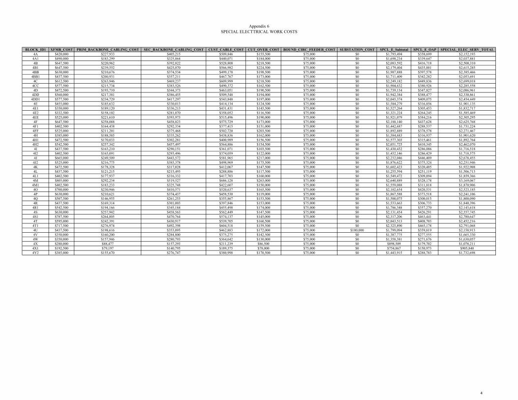
Appendix 6SPECIAL ELECTTRICAL WORK COSTS
BLOCK_ID1 XFMR_COST PRIM_BACKBONE_CABLING_COST SEC_BACKBONE_CABLING_COST CUST_CABLE_COST CUT_OVER_COST BOUND_CIRC_FEEDER_COST SUBSTATION_COST SPCL_E_Subtotal SPCL_E_OAP SPECIAL_ELEC_SERV_TOTAL4A $420,000 $227,933 $405,215 $509,846 $155,500 $75,000 $0 $1,793,494 $358,699 $2,152,193
4A1 $490,000 $183,299 $325,864 $440,071 $184,000 $75,000 $0 $1,698,234 $339,647 $2,037,8814B $647,500 $220,962 $392,822 $528,808 $218,500 $75,000 $0 $2,083,592 $416,718 $2,500,3104B1 $647,500 $239,552 $425,870 $566,982 $224,500 $75,000 $0 $2,179,404 $435,881 $2,615,2854BB $630,000 $210,676 $374,534 $499,178 $198,500 $75,000 $0 $1,987,888 $397,578 $2,385,4664BB1 $437,500 $200,931 $357,211 $467,767 $173,000 $75,000 $0 $1,711,409 $342,282 $2,053,691
4C $612,500 $263,946 $469,237 $609,999 $218,500 $75,000 $0 $2,249,182 $449,836 $2,699,0184CC $577,500 $215,734 $383,526 $490,372 $162,500 $75,000 $0 $1,904,632 $380,926 $2,285,5584D $472,500 $193,710 $344,373 $463,051 $190,500 $75,000 $0 $1,739,134 $347,827 $2,086,961
4DD $560,000 $217,381 $386,455 $509,548 $194,000 $75,000 $0 $1,942,384 $388,477 $2,330,8614DD1 $577,500 $234,729 $417,297 $543,848 $197,000 $75,000 $0 $2,045,374 $409,075 $2,454,449
4E $455,000 $185,632 $330,013 $414,134 $124,500 $75,000 $0 $1,584,279 $316,856 $1,901,1354E1 $350,000 $189,120 $336,213 $431,431 $145,500 $75,000 $0 $1,527,264 $305,453 $1,832,7174E2 $332,500 $158,102 $281,070 $358,052 $116,500 $75,000 $0 $1,321,224 $264,245 $1,585,4694EE $525,000 $221,610 $393,973 $515,496 $190,000 $75,000 $0 $1,921,079 $384,216 $2,305,2954F $647,500 $258,088 $458,823 $575,729 $173,000 $75,000 $0 $2,188,140 $437,628 $2,625,768
4F1 $402,500 $164,438 $292,334 $377,415 $131,000 $75,000 $0 $1,442,687 $288,537 $1,731,2244FF $525,000 $211,201 $375,468 $502,720 $203,500 $75,000 $0 $1,892,889 $378,578 $2,271,4674H $385,000 $188,585 $335,262 $438,836 $162,000 $75,000 $0 $1,584,683 $316,937 $1,901,620
4H1 $472,500 $170,033 $302,281 $400,989 $156,500 $75,000 $0 $1,577,303 $315,461 $1,892,7644H2 $542,500 $257,342 $457,497 $564,886 $154,500 $75,000 $0 $2,051,725 $410,345 $2,462,0704I $437,500 $163,210 $290,151 $361,071 $103,500 $75,000 $0 $1,430,432 $286,086 $1,716,5184I2 $402,500 $165,091 $293,496 $374,059 $122,000 $75,000 $0 $1,432,146 $286,429 $1,718,5754J $665,000 $249,509 $443,572 $581,965 $217,000 $75,000 $0 $2,232,046 $446,409 $2,678,455
4J2 $525,000 $216,775 $385,378 $498,969 $175,500 $75,000 $0 $1,876,622 $375,324 $2,251,9464K $472,500 $178,328 $317,028 $412,067 $147,500 $75,000 $0 $1,602,423 $320,485 $1,922,9084L $437,500 $121,215 $215,493 $288,886 $117,500 $75,000 $0 $1,255,594 $251,119 $1,506,7134L1 $402,500 $177,937 $316,332 $417,703 $160,000 $75,000 $0 $1,549,472 $309,894 $1,859,3664M $805,000 $292,234 $519,527 $686,128 $263,000 $75,000 $0 $2,640,889 $528,178 $3,169,067
4M1 $402,500 $183,233 $325,748 $422,607 $150,000 $75,000 $0 $1,559,088 $311,818 $1,870,9064O $700,000 $230,946 $410,571 $520,637 $165,500 $75,000 $0 $2,102,654 $420,531 $2,523,1854P $630,000 $210,621 $374,437 $458,530 $119,000 $75,000 $0 $1,867,588 $373,518 $2,241,1064Q $507,500 $146,955 $261,253 $355,867 $153,500 $75,000 $0 $1,500,075 $300,015 $1,800,0904R $437,500 $169,314 $301,003 $397,846 $153,000 $75,000 $0 $1,533,663 $306,733 $1,840,3964R1 $542,500 $194,166 $345,184 $455,498 $174,000 $75,000 $0 $1,786,348 $357,270 $2,143,6184S $630,000 $257,942 $458,563 $562,449 $147,500 $75,000 $0 $2,131,454 $426,291 $2,557,745
4S1 $787,500 $264,805 $470,764 $574,137 $145,000 $75,000 $0 $2,317,206 $463,441 $2,780,6474T $595,000 $242,391 $430,917 $539,705 $160,500 $75,000 $0 $2,043,513 $408,703 $2,452,2164T1 $717,500 $276,974 $492,398 $604,518 $159,500 $75,000 $0 $2,325,890 $465,178 $2,791,0684U $437,500 $198,616 $353,095 $462,883 $172,000 $75,000 $100,000 $1,799,094 $359,819 $2,158,9134V $350,000 $160,200 $284,800 $375,275 $142,500 $75,000 $0 $1,387,775 $277,555 $1,665,3304W $350,000 $157,946 $280,793 $364,642 $130,000 $75,000 $0 $1,358,381 $271,676 $1,630,0574X $280,000 $88,477 $157,293 $211,239 $86,500 $75,000 $0 $898,509 $179,702 $1,078,211
4X1 $192,500 $79,197 $140,795 $189,375 $78,000 $75,000 $0 $754,867 $150,973 $905,8404Y2 $385,000 $155,670 $276,747 $380,998 $170,500 $75,000 $0 $1,443,915 $288,783 $1,732,698
4
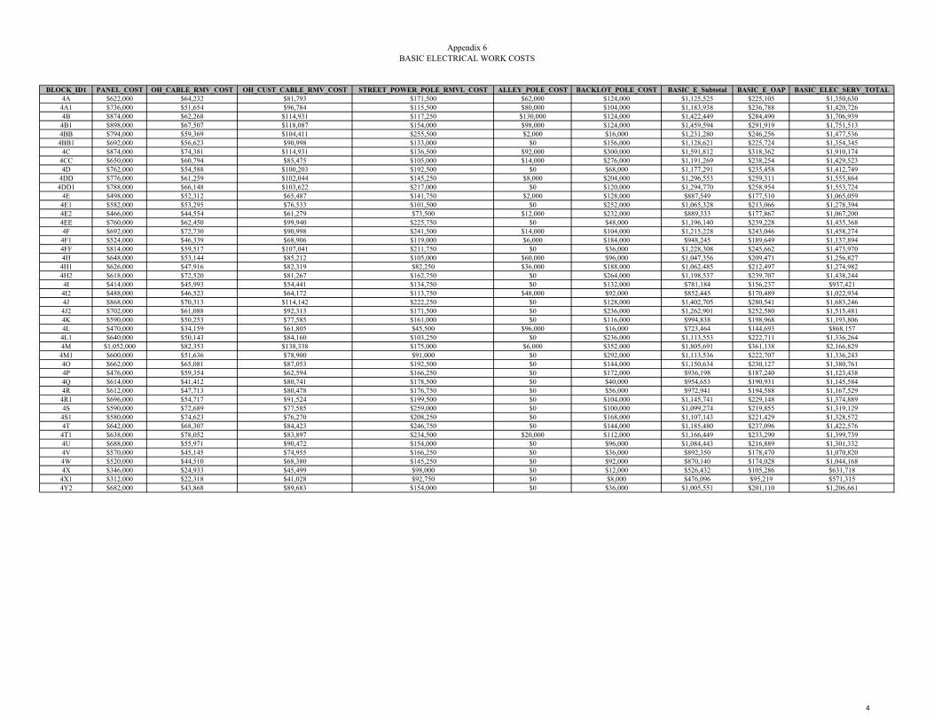
Appendix 6BASIC ELECTRICAL WORK COSTS
BLOCK_ID1 PANEL_COST OH_CABLE_RMV_COST OH_CUST_CABLE_RMV_COST STREET_POWER_POLE_RMVL_COST ALLEY_POLE_COST BACKLOT_POLE_COST BASIC_E_Subtotal BASIC_E_OAP BASIC_ELEC_SERV_TOTAL4A $622,000 $64,232 $81,793 $171,500 $62,000 $124,000 $1,125,525 $225,105 $1,350,6304A1 $736,000 $51,654 $96,784 $115,500 $80,000 $104,000 $1,183,938 $236,788 $1,420,7264B $874,000 $62,268 $114,931 $117,250 $130,000 $124,000 $1,422,449 $284,490 $1,706,9394B1 $898,000 $67,507 $118,087 $154,000 $98,000 $124,000 $1,459,594 $291,919 $1,751,5134BB $794,000 $59,369 $104,411 $255,500 $2,000 $16,000 $1,231,280 $246,256 $1,477,5364BB1 $692,000 $56,623 $90,998 $133,000 $0 $156,000 $1,128,621 $225,724 $1,354,345
4C $874,000 $74,381 $114,931 $136,500 $92,000 $300,000 $1,591,812 $318,362 $1,910,1744CC $650,000 $60,794 $85,475 $105,000 $14,000 $276,000 $1,191,269 $238,254 $1,429,5234D $762,000 $54,588 $100,203 $192,500 $0 $68,000 $1,177,291 $235,458 $1,412,749
4DD $776,000 $61,259 $102,044 $145,250 $8,000 $204,000 $1,296,553 $259,311 $1,555,8644DD1 $788,000 $66,148 $103,622 $217,000 $0 $120,000 $1,294,770 $258,954 $1,553,724
4E $498,000 $52,312 $65,487 $141,750 $2,000 $128,000 $887,549 $177,510 $1,065,0594E1 $582,000 $53,295 $76,533 $101,500 $0 $252,000 $1,065,328 $213,066 $1,278,3944E2 $466,000 $44,554 $61,279 $73,500 $12,000 $232,000 $889,333 $177,867 $1,067,2004EE $760,000 $62,450 $99,940 $225,750 $0 $48,000 $1,196,140 $239,228 $1,435,3684F $692,000 $72,730 $90,998 $241,500 $14,000 $104,000 $1,215,228 $243,046 $1,458,2744F1 $524,000 $46,339 $68,906 $119,000 $6,000 $184,000 $948,245 $189,649 $1,137,8944FF $814,000 $59,517 $107,041 $211,750 $0 $36,000 $1,228,308 $245,662 $1,473,9704H $648,000 $53,144 $85,212 $105,000 $60,000 $96,000 $1,047,356 $209,471 $1,256,8274H1 $626,000 $47,916 $82,319 $82,250 $36,000 $188,000 $1,062,485 $212,497 $1,274,9824H2 $618,000 $72,520 $81,267 $162,750 $0 $264,000 $1,198,537 $239,707 $1,438,2444I $414,000 $45,993 $54,441 $134,750 $0 $132,000 $781,184 $156,237 $937,4214I2 $488,000 $46,523 $64,172 $113,750 $48,000 $92,000 $852,445 $170,489 $1,022,9344J $868,000 $70,313 $114,142 $222,250 $0 $128,000 $1,402,705 $280,541 $1,683,2464J2 $702,000 $61,088 $92,313 $171,500 $0 $236,000 $1,262,901 $252,580 $1,515,4814K $590,000 $50,253 $77,585 $161,000 $0 $116,000 $994,838 $198,968 $1,193,8064L $470,000 $34,159 $61,805 $45,500 $96,000 $16,000 $723,464 $144,693 $868,1574L1 $640,000 $50,143 $84,160 $103,250 $0 $236,000 $1,113,553 $222,711 $1,336,2644M $1,052,000 $82,353 $138,338 $175,000 $6,000 $352,000 $1,805,691 $361,138 $2,166,8294M1 $600,000 $51,636 $78,900 $91,000 $0 $292,000 $1,113,536 $222,707 $1,336,2434O $662,000 $65,081 $87,053 $192,500 $0 $144,000 $1,150,634 $230,127 $1,380,7614P $476,000 $59,354 $62,594 $166,250 $0 $172,000 $936,198 $187,240 $1,123,4384Q $614,000 $41,412 $80,741 $178,500 $0 $40,000 $954,653 $190,931 $1,145,5844R $612,000 $47,713 $80,478 $176,750 $0 $56,000 $972,941 $194,588 $1,167,5294R1 $696,000 $54,717 $91,524 $199,500 $0 $104,000 $1,145,741 $229,148 $1,374,8894S $590,000 $72,689 $77,585 $259,000 $0 $100,000 $1,099,274 $219,855 $1,319,1294S1 $580,000 $74,623 $76,270 $208,250 $0 $168,000 $1,107,143 $221,429 $1,328,5724T $642,000 $68,307 $84,423 $246,750 $0 $144,000 $1,185,480 $237,096 $1,422,5764T1 $638,000 $78,052 $83,897 $234,500 $20,000 $112,000 $1,166,449 $233,290 $1,399,7394U $688,000 $55,971 $90,472 $154,000 $0 $96,000 $1,084,443 $216,889 $1,301,3324V $570,000 $45,145 $74,955 $166,250 $0 $36,000 $892,350 $178,470 $1,070,8204W $520,000 $44,510 $68,380 $145,250 $0 $92,000 $870,140 $174,028 $1,044,1684X $346,000 $24,933 $45,499 $98,000 $0 $12,000 $526,432 $105,286 $631,7184X1 $312,000 $22,318 $41,028 $92,750 $0 $8,000 $476,096 $95,219 $571,3154Y2 $682,000 $43,868 $89,683 $154,000 $0 $36,000 $1,005,551 $201,110 $1,206,661
4
UUP MASTER PLAN UPDATE – FACTORS AND METHOD
APPENDIX 6 DISTRICT 6
Appendix 6Updated 2009 Master Plan with Applied Current Algorithms
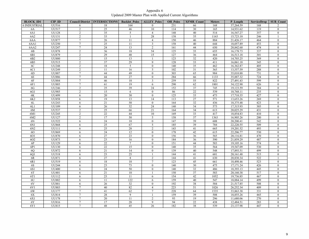
BLOCK_ID1 CIP_ID Council District INTERSECTIONS Backlot_Poles ALLEY_Poles OH_Poles XFMR_Count Meters P_Length ServiceDrop SUB_Count6 INDUSTRIAL UU516 6 18 164 0 231 66 168 37,264.59 168 2
6A UU517 2 25 46 10 114 30 165 14,931.62 119 06A1 UU128 2 35 5 4 148 40 514 16,547.27 357 06A2 UU131 2 33 1 28 138 35 1163 15,723.10 246 16AA UU877 7 26 11 4 150 46 884 21,426.17 464 0
6AA1 UU250 7 25 11 3 158 40 644 18,057.89 453 06AA2 UU247 7 24 13 2 161 44 650 20,842.60 474 0
6B UU878 2 36 18 54 125 35 655 16,178.73 337 06B1 UU879 2 29 48 15 127 36 464 16,513.18 301 06B2 UU880 2 15 13 1 123 32 420 14,703.25 369 06B3 UU515 2 37 29 9 128 33 411 16,061.18 345 06C UU248 2 18 5 0 140 35 462 16,362.87 405 0
6C1 UU249 2 11 16 5 102 31 365 13,557.59 288 06D UU887 7 44 49 0 303 65 984 35,010.88 731 06E UU886 7 44 27 0 284 66 1133 35,887.32 724 06F UU884 7 46 18 3 259 55 822 27,491.43 599 0
6F1 UU885 7 61 19 6 290 62 1801 34,122.90 626 06G UU246 2 25 39 24 152 37 745 19,123.59 384 0
6G1 UU985 2 15 6 0 86 22 539 10,768.11 235 06K UU499 6 20 30 0 125 33 473 17,710.35 427 0
6K2 UU858 6 19 13 14 113 27 571 13,653.26 269 06L UU243 6 21 50 0 164 32 436 18,375.48 423 0
6L1 UU109 6 26 32 24 140 34 573 17,315.93 303 06M UU537 2 25 66 21 164 34 613 20,025.29 431 0
6M1 UU245 2 22 44 10 169 33 417 18,854.83 410 06M2 UU127 2 17 50 5 158 37 1363 16,905.26 200 06N UU522 6 24 10 0 147 39 608 20,200.41 542 0
6N1 UU868 6 25 67 5 185 39 784 22,220.55 509 06N2 UU111 6 25 28 2 143 41 665 19,201.52 493 06O UU869 6 24 12 0 178 42 615 22,206.77 530 0
6O1 UU870 6 27 23 0 156 36 565 20,116.81 470 06O2 UU873 6 23 16 0 184 36 590 21,859.29 487 06P UU129 6 22 7 0 151 44 583 19,105.16 574 0
6P1 UU130 6 22 15 0 140 35 564 19,547.09 530 06Q UU872 6 21 14 0 139 40 548 17,893.51 499 0
6Q1 UU518 6 23 25 1 144 41 601 20,161.48 515 06R UU871 6 27 8 2 144 41 630 20,830.34 522 1
6R1 UU519 6 18 10 7 123 45 661 18,498.46 523 06S UU244 6 23 73 0 140 30 475 17,171.24 426 0
6S1 UU400 6 24 50 0 140 32 486 18,393.13 445 06T UU401 6 21 10 1 150 37 583 20,160.38 517 0
6T1 UU112 6 23 11 6 154 42 1052 19,736.85 467 06U UU882 6 11 122 6 159 40 547 18,884.14 499 06V UU881 6 26 32 0 192 38 584 21,517.85 508 0
6V1 UU883 7 40 82 4 223 51 1026 26,252.34 409 06W UU177 7 41 62 7 228 64 1535 33,863.38 331 06X UU814 7 28 9 1 159 39 508 18,855.26 465 0
6X1 UU178 7 20 11 2 93 19 296 11,680.06 270 06Y UU816 7 17 28 9 94 22 438 12,484.51 283 0
6Y1 UU815 7 48 45 26 182 38 539 23,137.98 447 0
9
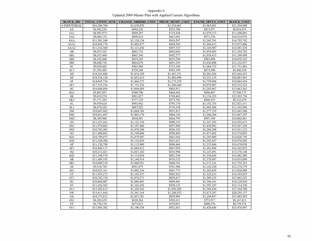
Appendix 6Updated 2009 Master Plan with Applied Current Algorithms
BLOCK_ID1 TOTAL_CONST_SUM CHANGE_ORDERS_COST PRGM_MGMT_COST ENGNR_SRVCS_COST BLOCK_COST6 INDUSTRIAL $16,380,760 $1,638,076 $1,310,461 $1,965,691 $21,294,988
6A $6,942,256 $694,226 $555,380 $833,071 $9,024,9336A1 $8,992,973 $899,297 $719,438 $1,079,157 $11,690,8656A2 $8,096,135 $809,614 $647,691 $971,536 $10,524,9766AA $11,381,340 $1,138,134 $910,507 $1,365,761 $14,795,742
6AA1 $10,056,774 $1,005,677 $804,542 $1,206,813 $13,073,8066AA2 $11,216,560 $1,121,656 $897,325 $1,345,987 $14,581,528
6B $8,657,525 $865,752 $692,602 $1,038,903 $11,254,7826B1 $8,653,460 $865,346 $692,277 $1,038,415 $11,249,4986B2 $8,192,448 $819,245 $655,396 $983,094 $10,650,1836B3 $8,640,736 $864,074 $691,259 $1,036,888 $11,232,9576C $9,039,602 $903,960 $723,168 $1,084,752 $11,751,482
6C1 $7,292,485 $729,248 $583,399 $875,098 $9,480,2306D $18,341,886 $1,834,189 $1,467,351 $2,201,026 $23,844,4526E $18,526,124 $1,852,612 $1,482,090 $2,223,135 $24,083,9616F $14,665,734 $1,466,573 $1,173,259 $1,759,888 $19,065,454
6F1 $17,332,556 $1,733,256 $1,386,604 $2,079,907 $22,532,3236G $10,048,894 $1,004,889 $803,912 $1,205,867 $13,063,562
6G1 $5,807,057 $580,706 $464,565 $696,847 $7,549,1756K $9,618,274 $961,827 $769,462 $1,154,193 $12,503,756
6K2 $7,171,292 $717,129 $573,703 $860,555 $9,322,6796L $9,939,624 $993,962 $795,170 $1,192,755 $12,921,511
6L1 $8,879,220 $887,922 $710,338 $1,065,506 $11,542,9866M $10,647,662 $1,064,766 $851,813 $1,277,719 $13,841,960
6M1 $10,051,697 $1,005,170 $804,136 $1,206,204 $13,067,2076M2 $8,309,908 $830,991 $664,793 $997,189 $10,802,8816N $11,227,441 $1,122,744 $898,195 $1,347,293 $14,595,673
6N1 $11,974,862 $1,197,486 $957,989 $1,436,983 $15,567,3206N2 $10,702,403 $1,070,240 $856,192 $1,284,288 $13,913,1236O $11,980,043 $1,198,004 $958,403 $1,437,605 $15,574,055
6O1 $10,799,073 $1,079,907 $863,926 $1,295,889 $14,038,7956O2 $11,520,388 $1,152,039 $921,631 $1,382,447 $14,976,5056P $11,130,798 $1,113,080 $890,464 $1,335,696 $14,470,038
6P1 $10,849,117 $1,084,912 $867,929 $1,301,894 $14,103,8526Q $10,212,421 $1,021,242 $816,994 $1,225,491 $13,276,148
6Q1 $11,140,376 $1,114,038 $891,230 $1,336,845 $14,482,4896R $11,489,145 $1,148,914 $919,132 $1,378,697 $14,935,888
6R1 $10,609,510 $1,060,951 $848,761 $1,273,141 $13,792,3636S $9,518,754 $951,875 $761,500 $1,142,250 $12,374,379
6S1 $10,022,161 $1,002,216 $801,773 $1,202,659 $13,028,8096T $11,035,273 $1,103,527 $882,822 $1,324,233 $14,345,855
6T1 $10,742,710 $1,074,271 $859,417 $1,289,125 $13,965,5236U $10,868,007 $1,086,801 $869,441 $1,304,161 $14,128,4106V $11,626,562 $1,162,656 $930,125 $1,395,187 $15,114,530
6V1 $13,203,615 $1,320,362 $1,056,289 $1,584,434 $17,164,7006W $15,611,644 $1,561,164 $1,248,932 $1,873,397 $20,295,1376X $10,373,812 $1,037,381 $829,905 $1,244,857 $13,485,955
6X1 $6,282,639 $628,264 $502,611 $753,917 $8,167,4316Y $6,738,134 $673,813 $539,051 $808,576 $8,759,574
6Y1 $11,905,382 $1,190,538 $952,431 $1,428,646 $15,476,997
10
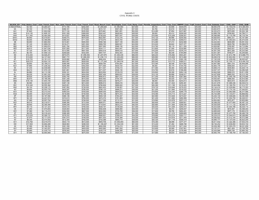
Appendix 6CIVIL WORK COSTS
BLOCK_ID1 Pub_Notice_Cost Joint_Trench_Cost Non_Joint_Trench_Cost Cust_Trench_Cost Road_Resurf_Cost Streetlights_Cost Curb_Ramp_Cost Permits_Inspections_Cost Tree_Cost SWPPP_Cost Traff_Control_Cost Civil_Subtotal_Cost CIVIL_OAP CIVIL_SUM6 INDUSTRIAL $4,180 $4,285,427 $714,166 $252,000 $1,285,628 $1,490,583 $27,000 $6,720 $3,696 $535,678 $45,000 $8,650,078 $1,730,016 $10,380,094
6A $4,150 $1,717,136 $286,161 $178,500 $515,141 $597,265 $37,500 $4,760 $2,618 $214,642 $45,000 $3,602,873 $720,575 $4,323,4486A1 $7,640 $1,902,936 $317,124 $535,500 $570,881 $661,891 $52,500 $14,280 $7,854 $237,867 $45,000 $4,353,473 $870,695 $5,224,1686A2 $14,130 $1,808,157 $301,329 $369,000 $542,447 $628,924 $49,500 $9,840 $5,412 $226,020 $45,000 $3,999,759 $799,952 $4,799,7116AA $11,340 $2,464,009 $410,627 $696,000 $739,203 $857,047 $39,000 $18,560 $10,208 $308,001 $45,000 $5,598,995 $1,119,799 $6,718,794
6AA1 $8,940 $2,076,657 $346,075 $679,500 $622,997 $722,316 $37,500 $18,120 $9,966 $259,582 $45,000 $4,826,653 $965,331 $5,791,9846AA2 $9,000 $2,396,899 $399,443 $711,000 $719,070 $833,704 $36,000 $18,960 $10,428 $299,612 $45,000 $5,479,116 $1,095,823 $6,574,939
6B $9,050 $1,860,554 $310,061 $505,500 $558,166 $647,149 $54,000 $13,480 $7,414 $232,569 $45,000 $4,242,943 $848,589 $5,091,5326B1 $7,140 $1,899,016 $316,471 $451,500 $569,705 $660,527 $43,500 $12,040 $6,622 $237,377 $45,000 $4,248,898 $849,780 $5,098,6786B2 $6,700 $1,690,874 $281,784 $553,500 $507,262 $588,130 $22,500 $14,760 $8,118 $211,359 $45,000 $3,929,987 $785,997 $4,715,9846B3 $6,610 $1,847,036 $307,809 $517,500 $554,111 $642,447 $55,500 $13,800 $7,590 $230,880 $45,000 $4,228,283 $845,657 $5,073,9406C $7,120 $1,881,730 $313,590 $607,500 $564,519 $654,515 $27,000 $16,200 $8,910 $235,216 $45,000 $4,361,300 $872,260 $5,233,560
6C1 $6,150 $1,559,123 $259,828 $432,000 $467,737 $542,303 $16,500 $11,520 $6,336 $194,890 $45,000 $3,541,387 $708,277 $4,249,6646D $12,340 $4,026,251 $670,975 $1,096,500 $1,207,875 $1,400,435 $66,000 $29,240 $16,082 $503,281 $45,000 $9,073,979 $1,814,796 $10,888,7756E $13,830 $4,127,042 $687,772 $1,086,000 $1,238,113 $1,435,493 $66,000 $28,960 $15,928 $515,880 $45,000 $9,260,018 $1,852,004 $11,112,0226F $10,720 $3,161,515 $526,866 $898,500 $948,454 $1,099,657 $69,000 $23,960 $13,178 $395,189 $45,000 $7,192,039 $1,438,408 $8,630,447
6F1 $20,510 $3,924,133 $653,957 $939,000 $1,177,240 $1,364,916 $91,500 $25,040 $13,772 $490,517 $45,000 $8,745,585 $1,749,117 $10,494,7026G $9,950 $2,199,213 $366,499 $576,000 $659,764 $764,944 $37,500 $15,360 $8,448 $274,902 $45,000 $4,957,580 $991,516 $5,949,096
6G1 $7,890 $1,238,332 $206,368 $352,500 $371,500 $430,724 $22,500 $9,400 $5,170 $154,792 $45,000 $2,844,176 $568,835 $3,413,0116K $7,230 $2,036,690 $339,414 $640,500 $611,007 $708,414 $30,000 $17,080 $9,394 $254,586 $45,000 $4,699,315 $939,863 $5,639,1786K2 $8,210 $1,570,125 $261,661 $403,500 $471,037 $546,130 $28,500 $10,760 $5,918 $196,266 $45,000 $3,547,107 $709,421 $4,256,5286L $6,860 $2,113,180 $352,161 $634,500 $633,954 $735,019 $31,500 $16,920 $9,306 $264,148 $45,000 $4,842,548 $968,510 $5,811,0586L1 $8,230 $1,991,332 $331,856 $454,500 $597,400 $692,637 $39,000 $12,120 $6,666 $248,917 $45,000 $4,427,658 $885,532 $5,313,1906M $8,630 $2,302,909 $383,780 $646,500 $690,873 $801,012 $37,500 $17,240 $9,482 $287,864 $45,000 $5,230,790 $1,046,158 $6,276,9486M1 $6,670 $2,168,306 $361,348 $615,000 $650,492 $754,193 $33,000 $16,400 $9,020 $271,038 $45,000 $4,930,467 $986,093 $5,916,5606M2 $16,130 $1,944,105 $323,985 $300,000 $583,232 $676,211 $25,500 $8,000 $4,400 $243,013 $45,000 $4,169,576 $833,915 $5,003,4916N $8,580 $2,323,047 $387,136 $813,000 $696,914 $808,016 $36,000 $21,680 $11,924 $290,381 $45,000 $5,441,678 $1,088,336 $6,530,014
6N1 $10,340 $2,555,364 $425,851 $763,500 $766,609 $888,822 $37,500 $20,360 $11,198 $319,420 $45,000 $5,843,964 $1,168,793 $7,012,7576N2 $9,150 $2,208,175 $367,992 $739,500 $662,453 $768,061 $37,500 $19,720 $10,846 $276,022 $45,000 $5,144,419 $1,028,884 $6,173,3036O $8,650 $2,553,778 $425,587 $795,000 $766,133 $888,271 $36,000 $21,200 $11,660 $319,222 $45,000 $5,870,501 $1,174,100 $7,044,601
6O1 $8,150 $2,313,433 $385,534 $705,000 $694,030 $804,672 $40,500 $18,800 $10,340 $289,179 $45,000 $5,314,638 $1,062,928 $6,377,5666O2 $8,400 $2,513,818 $418,928 $730,500 $754,146 $874,372 $34,500 $19,480 $10,714 $314,227 $45,000 $5,724,085 $1,144,817 $6,868,9026P $8,330 $2,197,094 $366,146 $861,000 $659,128 $764,207 $33,000 $22,960 $12,628 $274,637 $45,000 $5,244,130 $1,048,826 $6,292,9566P1 $8,140 $2,247,915 $374,615 $795,000 $674,374 $781,883 $33,000 $21,200 $11,660 $280,989 $45,000 $5,273,776 $1,054,755 $6,328,5316Q $7,980 $2,057,754 $342,925 $748,500 $617,326 $715,741 $31,500 $19,960 $10,978 $257,219 $45,000 $4,854,883 $970,977 $5,825,860
6Q1 $8,510 $2,318,571 $386,390 $772,500 $695,571 $806,459 $34,500 $20,600 $11,330 $289,821 $45,000 $5,389,252 $1,077,850 $6,467,1026R $8,800 $2,395,490 $399,208 $783,000 $718,647 $833,214 $40,500 $20,880 $11,484 $299,436 $45,000 $5,555,659 $1,111,132 $6,666,791
6R1 $9,110 $2,127,323 $354,518 $784,500 $638,197 $739,939 $27,000 $20,920 $11,506 $265,915 $45,000 $5,023,928 $1,004,786 $6,028,7146S $7,250 $1,974,693 $329,083 $639,000 $592,408 $686,850 $34,500 $17,040 $9,372 $246,837 $45,000 $4,582,033 $916,407 $5,498,4406S1 $7,360 $2,115,210 $352,500 $667,500 $634,563 $735,725 $36,000 $17,800 $9,790 $264,401 $45,000 $4,885,849 $977,170 $5,863,0196T $8,330 $2,318,443 $386,369 $775,500 $695,533 $806,415 $31,500 $20,680 $11,374 $289,805 $45,000 $5,388,949 $1,077,790 $6,466,739
6T1 $13,020 $2,269,737 $378,252 $700,500 $680,921 $789,474 $34,500 $18,680 $10,274 $283,717 $45,000 $5,224,075 $1,044,815 $6,268,8906U $7,970 $2,171,676 $361,910 $748,500 $651,503 $755,366 $16,500 $19,960 $10,978 $271,459 $45,000 $5,060,822 $1,012,164 $6,072,9866V $8,340 $2,474,552 $412,384 $762,000 $742,366 $860,714 $39,000 $20,320 $11,176 $309,319 $45,000 $5,685,171 $1,137,034 $6,822,2056V1 $12,760 $3,019,019 $503,119 $613,500 $905,706 $1,050,093 $60,000 $16,360 $8,998 $377,377 $45,000 $6,611,932 $1,322,386 $7,934,3186W $17,850 $3,894,289 $648,983 $496,500 $1,168,287 $1,354,535 $61,500 $13,240 $7,282 $486,786 $45,000 $8,194,252 $1,638,850 $9,833,1026X $7,580 $2,168,354 $361,356 $697,500 $650,506 $754,210 $42,000 $18,600 $10,230 $271,044 $45,000 $5,026,380 $1,005,276 $6,031,656
6X1 $5,460 $1,343,207 $223,845 $405,000 $402,962 $467,202 $30,000 $10,800 $5,940 $167,901 $45,000 $3,107,317 $621,463 $3,728,7806Y $6,880 $1,435,719 $239,262 $424,500 $430,716 $499,380 $25,500 $11,320 $6,226 $179,465 $45,000 $3,303,968 $660,794 $3,964,762
6Y1 $7,890 $2,660,868 $443,434 $670,500 $798,260 $925,519 $72,000 $17,880 $9,834 $332,609 $45,000 $5,983,794 $1,196,759 $7,180,553
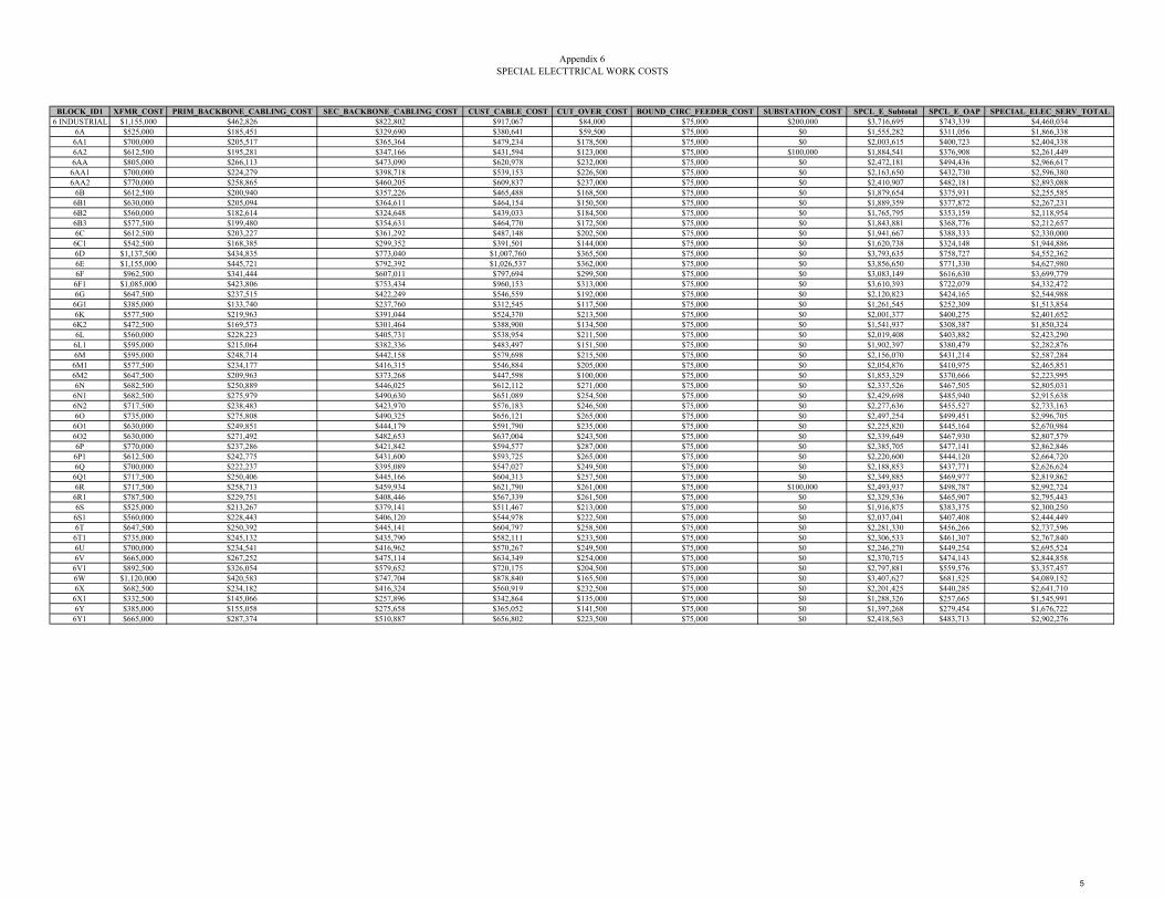
Appendix 6SPECIAL ELECTTRICAL WORK COSTS
BLOCK_ID1 XFMR_COST PRIM_BACKBONE_CABLING_COST SEC_BACKBONE_CABLING_COST CUST_CABLE_COST CUT_OVER_COST BOUND_CIRC_FEEDER_COST SUBSTATION_COST SPCL_E_Subtotal SPCL_E_OAP SPECIAL_ELEC_SERV_TOTAL6 INDUSTRIAL $1,155,000 $462,826 $822,802 $917,067 $84,000 $75,000 $200,000 $3,716,695 $743,339 $4,460,034
6A $525,000 $185,451 $329,690 $380,641 $59,500 $75,000 $0 $1,555,282 $311,056 $1,866,3386A1 $700,000 $205,517 $365,364 $479,234 $178,500 $75,000 $0 $2,003,615 $400,723 $2,404,3386A2 $612,500 $195,281 $347,166 $431,594 $123,000 $75,000 $100,000 $1,884,541 $376,908 $2,261,4496AA $805,000 $266,113 $473,090 $620,978 $232,000 $75,000 $0 $2,472,181 $494,436 $2,966,617
6AA1 $700,000 $224,279 $398,718 $539,153 $226,500 $75,000 $0 $2,163,650 $432,730 $2,596,3806AA2 $770,000 $258,865 $460,205 $609,837 $237,000 $75,000 $0 $2,410,907 $482,181 $2,893,088
6B $612,500 $200,940 $357,226 $465,488 $168,500 $75,000 $0 $1,879,654 $375,931 $2,255,5856B1 $630,000 $205,094 $364,611 $464,154 $150,500 $75,000 $0 $1,889,359 $377,872 $2,267,2316B2 $560,000 $182,614 $324,648 $439,033 $184,500 $75,000 $0 $1,765,795 $353,159 $2,118,9546B3 $577,500 $199,480 $354,631 $464,770 $172,500 $75,000 $0 $1,843,881 $368,776 $2,212,6576C $612,500 $203,227 $361,292 $487,148 $202,500 $75,000 $0 $1,941,667 $388,333 $2,330,0006C1 $542,500 $168,385 $299,352 $391,501 $144,000 $75,000 $0 $1,620,738 $324,148 $1,944,8866D $1,137,500 $434,835 $773,040 $1,007,760 $365,500 $75,000 $0 $3,793,635 $758,727 $4,552,3626E $1,155,000 $445,721 $792,392 $1,026,537 $362,000 $75,000 $0 $3,856,650 $771,330 $4,627,9806F $962,500 $341,444 $607,011 $797,694 $299,500 $75,000 $0 $3,083,149 $616,630 $3,699,779
6F1 $1,085,000 $423,806 $753,434 $960,153 $313,000 $75,000 $0 $3,610,393 $722,079 $4,332,4726G $647,500 $237,515 $422,249 $546,559 $192,000 $75,000 $0 $2,120,823 $424,165 $2,544,988
6G1 $385,000 $133,740 $237,760 $312,545 $117,500 $75,000 $0 $1,261,545 $252,309 $1,513,8546K $577,500 $219,963 $391,044 $524,370 $213,500 $75,000 $0 $2,001,377 $400,275 $2,401,652
6K2 $472,500 $169,573 $301,464 $388,900 $134,500 $75,000 $0 $1,541,937 $308,387 $1,850,3246L $560,000 $228,223 $405,731 $538,954 $211,500 $75,000 $0 $2,019,408 $403,882 $2,423,2906L1 $595,000 $215,064 $382,336 $483,497 $151,500 $75,000 $0 $1,902,397 $380,479 $2,282,8766M $595,000 $248,714 $442,158 $579,698 $215,500 $75,000 $0 $2,156,070 $431,214 $2,587,284
6M1 $577,500 $234,177 $416,315 $546,884 $205,000 $75,000 $0 $2,054,876 $410,975 $2,465,8516M2 $647,500 $209,963 $373,268 $447,598 $100,000 $75,000 $0 $1,853,329 $370,666 $2,223,9956N $682,500 $250,889 $446,025 $612,112 $271,000 $75,000 $0 $2,337,526 $467,505 $2,805,031
6N1 $682,500 $275,979 $490,630 $651,089 $254,500 $75,000 $0 $2,429,698 $485,940 $2,915,6386N2 $717,500 $238,483 $423,970 $576,183 $246,500 $75,000 $0 $2,277,636 $455,527 $2,733,1636O $735,000 $275,808 $490,325 $656,121 $265,000 $75,000 $0 $2,497,254 $499,451 $2,996,705
6O1 $630,000 $249,851 $444,179 $591,790 $235,000 $75,000 $0 $2,225,820 $445,164 $2,670,9846O2 $630,000 $271,492 $482,653 $637,004 $243,500 $75,000 $0 $2,339,649 $467,930 $2,807,5796P $770,000 $237,286 $421,842 $594,577 $287,000 $75,000 $0 $2,385,705 $477,141 $2,862,846
6P1 $612,500 $242,775 $431,600 $593,725 $265,000 $75,000 $0 $2,220,600 $444,120 $2,664,7206Q $700,000 $222,237 $395,089 $547,027 $249,500 $75,000 $0 $2,188,853 $437,771 $2,626,624
6Q1 $717,500 $250,406 $445,166 $604,313 $257,500 $75,000 $0 $2,349,885 $469,977 $2,819,8626R $717,500 $258,713 $459,934 $621,790 $261,000 $75,000 $100,000 $2,493,937 $498,787 $2,992,7246R1 $787,500 $229,751 $408,446 $567,339 $261,500 $75,000 $0 $2,329,536 $465,907 $2,795,4436S $525,000 $213,267 $379,141 $511,467 $213,000 $75,000 $0 $1,916,875 $383,375 $2,300,250
6S1 $560,000 $228,443 $406,120 $544,978 $222,500 $75,000 $0 $2,037,041 $407,408 $2,444,4496T $647,500 $250,392 $445,141 $604,797 $258,500 $75,000 $0 $2,281,330 $456,266 $2,737,5966T1 $735,000 $245,132 $435,790 $582,111 $233,500 $75,000 $0 $2,306,533 $461,307 $2,767,8406U $700,000 $234,541 $416,962 $570,267 $249,500 $75,000 $0 $2,246,270 $449,254 $2,695,5246V $665,000 $267,252 $475,114 $634,349 $254,000 $75,000 $0 $2,370,715 $474,143 $2,844,858
6V1 $892,500 $326,054 $579,652 $720,175 $204,500 $75,000 $0 $2,797,881 $559,576 $3,357,4576W $1,120,000 $420,583 $747,704 $878,840 $165,500 $75,000 $0 $3,407,627 $681,525 $4,089,1526X $682,500 $234,182 $416,324 $560,919 $232,500 $75,000 $0 $2,201,425 $440,285 $2,641,710
6X1 $332,500 $145,066 $257,896 $342,864 $135,000 $75,000 $0 $1,288,326 $257,665 $1,545,9916Y $385,000 $155,058 $275,658 $365,052 $141,500 $75,000 $0 $1,397,268 $279,454 $1,676,722
6Y1 $665,000 $287,374 $510,887 $656,802 $223,500 $75,000 $0 $2,418,563 $483,713 $2,902,276
5
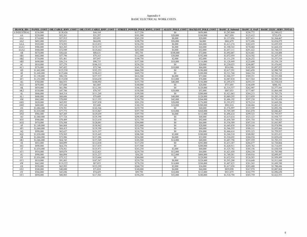
Appendix 6BASIC ELECTRICAL WORK COSTS
BLOCK_ID1 PANEL_COST OH_CABLE_RMV_COST OH_CUST_CABLE_RMV_COST STREET_POWER_POLE_RMVL_COST ALLEY_POLE_COST BACKLOT_POLE_COST BASIC_E_Subtotal BASIC_E_OAP BASIC_ELEC_SERV_TOTAL6 INDUSTRIAL $336,000 $130,426 $44,184 $117,250 $0 $656,000 $1,283,860 $256,772 $1,540,632
6A $238,000 $52,261 $31,297 $101,500 $20,000 $184,000 $627,058 $125,412 $752,4706A1 $714,000 $57,915 $93,891 $243,250 $8,000 $20,000 $1,137,056 $227,411 $1,364,4676A2 $492,000 $55,031 $64,698 $190,750 $56,000 $4,000 $862,479 $172,496 $1,034,9756AA $928,000 $74,992 $122,032 $236,250 $8,000 $44,000 $1,413,274 $282,655 $1,695,9296AA1 $906,000 $63,203 $119,139 $252,000 $6,000 $44,000 $1,390,342 $278,068 $1,668,4106AA2 $948,000 $72,949 $124,662 $255,500 $4,000 $52,000 $1,457,111 $291,422 $1,748,533
6B $674,000 $56,626 $88,631 $92,750 $108,000 $72,000 $1,092,007 $218,401 $1,310,4086B1 $602,000 $57,796 $79,163 $112,000 $30,000 $192,000 $1,072,959 $214,592 $1,287,5516B2 $738,000 $51,461 $97,047 $190,750 $2,000 $52,000 $1,131,258 $226,252 $1,357,5106B3 $690,000 $56,214 $90,735 $157,500 $18,000 $116,000 $1,128,449 $225,690 $1,354,1396C $810,000 $57,270 $106,515 $236,250 $0 $20,000 $1,230,035 $246,007 $1,476,0426C1 $576,000 $47,452 $75,744 $141,750 $10,000 $64,000 $914,946 $182,989 $1,097,9356D $1,462,000 $122,538 $192,253 $444,500 $0 $196,000 $2,417,291 $483,458 $2,900,7496E $1,448,000 $125,606 $190,412 $449,750 $0 $108,000 $2,321,768 $464,354 $2,786,1226F $1,198,000 $96,220 $157,537 $416,500 $6,000 $72,000 $1,946,257 $389,251 $2,335,5086F1 $1,252,000 $119,430 $164,638 $463,750 $12,000 $76,000 $2,087,818 $417,564 $2,505,3826G $768,000 $66,933 $100,992 $155,750 $48,000 $156,000 $1,295,675 $259,135 $1,554,8106G1 $470,000 $37,688 $61,805 $140,000 $0 $24,000 $733,493 $146,699 $880,1926K $854,000 $61,986 $112,301 $166,250 $0 $120,000 $1,314,537 $262,907 $1,577,4446K2 $538,000 $47,786 $70,747 $150,500 $28,000 $52,000 $887,033 $177,407 $1,064,4406L $846,000 $64,314 $111,249 $199,500 $0 $200,000 $1,421,063 $284,213 $1,705,2766L1 $606,000 $60,606 $79,689 $147,000 $48,000 $128,000 $1,069,295 $213,859 $1,283,1546M $862,000 $70,089 $113,353 $134,750 $42,000 $264,000 $1,486,192 $297,238 $1,783,4306M1 $820,000 $65,992 $107,830 $201,250 $20,000 $176,000 $1,391,072 $278,214 $1,669,2866M2 $400,000 $59,168 $52,600 $180,250 $10,000 $200,000 $902,018 $180,404 $1,082,4226N $1,084,000 $70,701 $142,546 $239,750 $0 $40,000 $1,576,997 $315,399 $1,892,3966N1 $1,018,000 $77,772 $133,867 $197,750 $10,000 $268,000 $1,705,389 $341,078 $2,046,4676N2 $986,000 $67,205 $129,659 $197,750 $4,000 $112,000 $1,496,614 $299,323 $1,795,9376O $1,060,000 $77,724 $139,390 $290,500 $0 $48,000 $1,615,614 $323,123 $1,938,7376O1 $940,000 $70,409 $123,610 $232,750 $0 $92,000 $1,458,769 $291,754 $1,750,5236O2 $974,000 $76,508 $128,081 $294,000 $0 $64,000 $1,536,589 $307,318 $1,843,9076P $1,148,000 $66,868 $150,962 $252,000 $0 $28,000 $1,645,830 $329,166 $1,974,9966P1 $1,060,000 $68,415 $139,390 $218,750 $0 $60,000 $1,546,555 $309,311 $1,855,8666Q $998,000 $62,627 $131,237 $218,750 $0 $56,000 $1,466,614 $293,323 $1,759,9376Q1 $1,030,000 $70,565 $135,445 $206,500 $2,000 $100,000 $1,544,510 $308,902 $1,853,4126R $1,044,000 $72,906 $137,286 $234,500 $4,000 $32,000 $1,524,692 $304,938 $1,829,6306R1 $1,046,000 $64,745 $137,549 $185,500 $14,000 $40,000 $1,487,794 $297,559 $1,785,3536S $852,000 $60,099 $112,038 $117,250 $0 $292,000 $1,433,387 $286,677 $1,720,0646S1 $890,000 $64,376 $117,035 $157,500 $0 $200,000 $1,428,911 $285,782 $1,714,6936T $1,034,000 $70,561 $135,971 $243,250 $2,000 $40,000 $1,525,782 $305,156 $1,830,9386T1 $934,000 $69,079 $122,821 $239,750 $12,000 $44,000 $1,421,650 $284,330 $1,705,9806U $998,000 $66,094 $131,237 $54,250 $12,000 $488,000 $1,749,581 $349,916 $2,099,4976V $1,016,000 $75,312 $133,604 $280,000 $0 $128,000 $1,632,916 $326,583 $1,959,4996V1 $818,000 $91,883 $107,567 $239,750 $8,000 $328,000 $1,593,200 $318,640 $1,911,8406W $662,000 $118,522 $87,053 $278,250 $14,000 $248,000 $1,407,825 $281,565 $1,689,3906X $930,000 $65,993 $122,295 $260,750 $2,000 $36,000 $1,417,038 $283,408 $1,700,4466X1 $540,000 $40,880 $71,010 $140,000 $4,000 $44,000 $839,890 $167,978 $1,007,8686Y $566,000 $43,696 $74,429 $99,750 $18,000 $112,000 $913,875 $182,775 $1,096,6506Y1 $894,000 $80,983 $117,561 $194,250 $52,000 $180,000 $1,518,794 $303,759 $1,822,553
5

UUP MASTER PLAN UPDATE – FACTORS AND METHOD
APPENDIX 6 DISTRICT 7
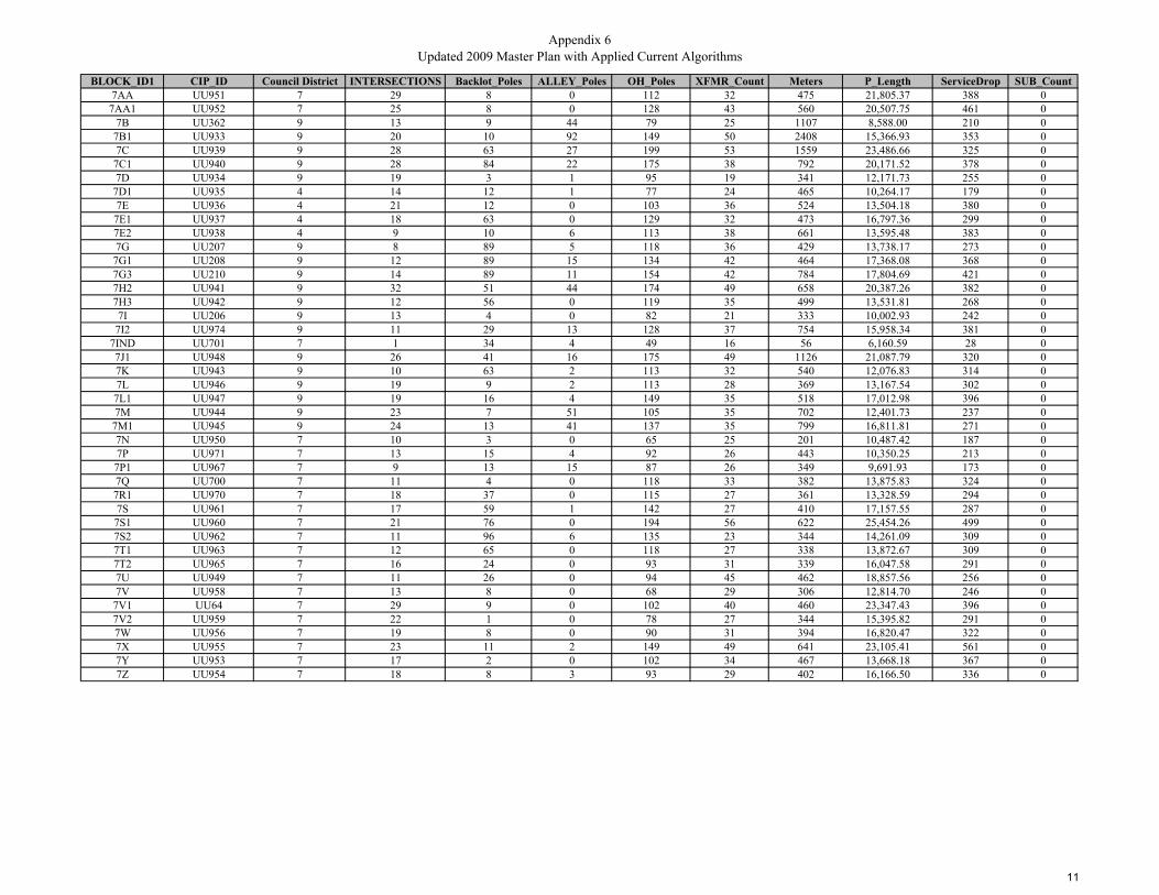
Appendix 6Updated 2009 Master Plan with Applied Current Algorithms
BLOCK_ID1 CIP_ID Council District INTERSECTIONS Backlot_Poles ALLEY_Poles OH_Poles XFMR_Count Meters P_Length ServiceDrop SUB_Count7AA UU951 7 29 8 0 112 32 475 21,805.37 388 0
7AA1 UU952 7 25 8 0 128 43 560 20,507.75 461 07B UU362 9 13 9 44 79 25 1107 8,588.00 210 0
7B1 UU933 9 20 10 92 149 50 2408 15,366.93 353 07C UU939 9 28 63 27 199 53 1559 23,486.66 325 0
7C1 UU940 9 28 84 22 175 38 792 20,171.52 378 07D UU934 9 19 3 1 95 19 341 12,171.73 255 0
7D1 UU935 4 14 12 1 77 24 465 10,264.17 179 07E UU936 4 21 12 0 103 36 524 13,504.18 380 0
7E1 UU937 4 18 63 0 129 32 473 16,797.36 299 07E2 UU938 4 9 10 6 113 38 661 13,595.48 383 07G UU207 9 8 89 5 118 36 429 13,738.17 273 0
7G1 UU208 9 12 89 15 134 42 464 17,368.08 368 07G3 UU210 9 14 89 11 154 42 784 17,804.69 421 07H2 UU941 9 32 51 44 174 49 658 20,387.26 382 07H3 UU942 9 12 56 0 119 35 499 13,531.81 268 07I UU206 9 13 4 0 82 21 333 10,002.93 242 0
7I2 UU974 9 11 29 13 128 37 754 15,958.34 381 07IND UU701 7 1 34 4 49 16 56 6,160.59 28 07J1 UU948 9 26 41 16 175 49 1126 21,087.79 320 07K UU943 9 10 63 2 113 32 540 12,076.83 314 07L UU946 9 19 9 2 113 28 369 13,167.54 302 0
7L1 UU947 9 19 16 4 149 35 518 17,012.98 396 07M UU944 9 23 7 51 105 35 702 12,401.73 237 0
7M1 UU945 9 24 13 41 137 35 799 16,811.81 271 07N UU950 7 10 3 0 65 25 201 10,487.42 187 07P UU971 7 13 15 4 92 26 443 10,350.25 213 0
7P1 UU967 7 9 13 15 87 26 349 9,691.93 173 07Q UU700 7 11 4 0 118 33 382 13,875.83 324 07R1 UU970 7 18 37 0 115 27 361 13,328.59 294 07S UU961 7 17 59 1 142 27 410 17,157.55 287 0
7S1 UU960 7 21 76 0 194 56 622 25,454.26 499 07S2 UU962 7 11 96 6 135 23 344 14,261.09 309 07T1 UU963 7 12 65 0 118 27 338 13,872.67 309 07T2 UU965 7 16 24 0 93 31 339 16,047.58 291 07U UU949 7 11 26 0 94 45 462 18,857.56 256 07V UU958 7 13 8 0 68 29 306 12,814.70 246 0
7V1 UU64 7 29 9 0 102 40 460 23,347.43 396 07V2 UU959 7 22 1 0 78 27 344 15,395.82 291 07W UU956 7 19 8 0 90 31 394 16,820.47 322 07X UU955 7 23 11 2 149 49 641 23,105.41 561 07Y UU953 7 17 2 0 102 34 467 13,668.18 367 07Z UU954 7 18 8 3 93 29 402 16,166.50 336 0
11
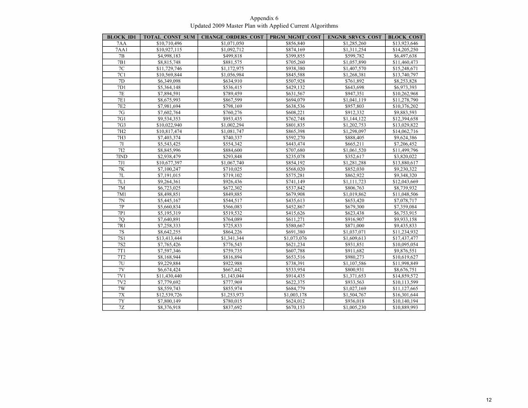
Appendix 6Updated 2009 Master Plan with Applied Current Algorithms
BLOCK_ID1 TOTAL_CONST_SUM CHANGE_ORDERS_COST PRGM_MGMT_COST ENGNR_SRVCS_COST BLOCK_COST7AA $10,710,496 $1,071,050 $856,840 $1,285,260 $13,923,646
7AA1 $10,927,115 $1,092,712 $874,169 $1,311,254 $14,205,2507B $4,998,183 $499,818 $399,855 $599,782 $6,497,638
7B1 $8,815,748 $881,575 $705,260 $1,057,890 $11,460,4737C $11,729,746 $1,172,975 $938,380 $1,407,570 $15,248,671
7C1 $10,569,844 $1,056,984 $845,588 $1,268,381 $13,740,7977D $6,349,098 $634,910 $507,928 $761,892 $8,253,828
7D1 $5,364,148 $536,415 $429,132 $643,698 $6,973,3937E $7,894,591 $789,459 $631,567 $947,351 $10,262,968
7E1 $8,675,993 $867,599 $694,079 $1,041,119 $11,278,7907E2 $7,981,694 $798,169 $638,536 $957,803 $10,376,2027G $7,602,764 $760,276 $608,221 $912,332 $9,883,593
7G1 $9,534,353 $953,435 $762,748 $1,144,122 $12,394,6587G3 $10,022,940 $1,002,294 $801,835 $1,202,753 $13,029,8227H2 $10,817,474 $1,081,747 $865,398 $1,298,097 $14,062,7167H3 $7,403,374 $740,337 $592,270 $888,405 $9,624,3867I $5,543,425 $554,342 $443,474 $665,211 $7,206,452
7I2 $8,845,996 $884,600 $707,680 $1,061,520 $11,499,7967IND $2,938,479 $293,848 $235,078 $352,617 $3,820,0227J1 $10,677,397 $1,067,740 $854,192 $1,281,288 $13,880,6177K $7,100,247 $710,025 $568,020 $852,030 $9,230,3227L $7,191,015 $719,102 $575,281 $862,922 $9,348,320
7L1 $9,264,361 $926,436 $741,149 $1,111,723 $12,043,6697M $6,723,025 $672,302 $537,842 $806,763 $8,739,932
7M1 $8,498,851 $849,885 $679,908 $1,019,862 $11,048,5067N $5,445,167 $544,517 $435,613 $653,420 $7,078,7177P $5,660,834 $566,083 $452,867 $679,300 $7,359,084
7P1 $5,195,319 $519,532 $415,626 $623,438 $6,753,9157Q $7,640,891 $764,089 $611,271 $916,907 $9,933,1587R1 $7,258,333 $725,833 $580,667 $871,000 $9,435,8337S $8,642,255 $864,226 $691,380 $1,037,071 $11,234,932
7S1 $13,413,444 $1,341,344 $1,073,076 $1,609,613 $17,437,4777S2 $7,765,426 $776,543 $621,234 $931,851 $10,095,0547T1 $7,597,346 $759,735 $607,788 $911,682 $9,876,5517T2 $8,168,944 $816,894 $653,516 $980,273 $10,619,6277U $9,229,884 $922,988 $738,391 $1,107,586 $11,998,8497V $6,674,424 $667,442 $533,954 $800,931 $8,676,751
7V1 $11,430,440 $1,143,044 $914,435 $1,371,653 $14,859,5727V2 $7,779,692 $777,969 $622,375 $933,563 $10,113,5997W $8,559,743 $855,974 $684,779 $1,027,169 $11,127,6657X $12,539,726 $1,253,973 $1,003,178 $1,504,767 $16,301,6447Y $7,800,149 $780,015 $624,012 $936,018 $10,140,1947Z $8,376,918 $837,692 $670,153 $1,005,230 $10,889,993
12

Appendix 6CIVIL WORK COSTS
BLOCK_ID1 Pub_Notice_Cost Joint_Trench_Cost Non_Joint_Trench_Cost Cust_Trench_Cost Road_Resurf_Cost Streetlights_Cost Curb_Ramp_Cost Permits_Inspections_Cost Tree_Cost SWPPP_Cost Traff_Control_Cost Civil_Subtotal_Cost CIVIL_OAP CIVIL_SUM7AA $7,250 $2,507,618 $417,894 $582,000 $752,285 $872,215 $43,500 $15,520 $8,536 $313,452 $45,000 $5,565,270 $1,113,054 $6,678,324
7AA1 $8,100 $2,358,391 $393,026 $691,500 $707,517 $820,310 $37,500 $18,440 $10,142 $294,799 $45,000 $5,384,725 $1,076,945 $6,461,6707B $13,570 $987,619 $164,587 $315,000 $296,286 $343,520 $19,500 $8,400 $4,620 $123,452 $45,000 $2,321,554 $464,311 $2,785,8657B1 $26,580 $1,767,197 $294,503 $529,500 $530,159 $614,677 $30,000 $14,120 $7,766 $220,900 $45,000 $4,080,402 $816,080 $4,896,4827C $18,090 $2,700,966 $450,116 $487,500 $810,290 $939,466 $42,000 $13,000 $7,150 $337,621 $45,000 $5,851,199 $1,170,240 $7,021,439
7C1 $10,420 $2,319,725 $386,582 $567,000 $695,918 $806,861 $42,000 $15,120 $8,316 $289,966 $45,000 $5,186,908 $1,037,382 $6,224,2907D $5,910 $1,399,749 $233,268 $382,500 $419,925 $486,869 $28,500 $10,200 $5,610 $174,969 $45,000 $3,192,500 $638,500 $3,831,000
7D1 $7,150 $1,180,380 $196,710 $268,500 $354,114 $410,567 $21,000 $7,160 $3,938 $147,547 $45,000 $2,642,066 $528,413 $3,170,4797E $7,740 $1,552,981 $258,804 $570,000 $465,894 $540,167 $31,500 $15,200 $8,360 $194,123 $45,000 $3,689,769 $737,954 $4,427,7237E1 $7,230 $1,931,696 $321,917 $448,500 $579,509 $671,894 $27,000 $11,960 $6,578 $241,462 $45,000 $4,292,746 $858,549 $5,151,2957E2 $9,110 $1,563,481 $260,554 $574,500 $469,044 $543,819 $13,500 $15,320 $8,426 $195,435 $45,000 $3,698,189 $739,638 $4,437,8277G $6,790 $1,579,889 $263,289 $409,500 $473,967 $549,527 $12,000 $10,920 $6,006 $197,486 $45,000 $3,554,374 $710,875 $4,265,249
7G1 $7,140 $1,997,329 $332,855 $552,000 $599,199 $694,723 $18,000 $14,720 $8,096 $249,666 $45,000 $4,518,728 $903,746 $5,422,4747G3 $10,340 $2,047,540 $341,222 $631,500 $614,262 $712,188 $21,000 $16,840 $9,262 $255,942 $45,000 $4,705,096 $941,019 $5,646,1157H2 $9,080 $2,344,535 $390,717 $573,000 $703,361 $815,491 $48,000 $15,280 $8,404 $293,067 $45,000 $5,245,935 $1,049,187 $6,295,1227H3 $7,490 $1,556,159 $259,334 $402,000 $466,848 $541,273 $18,000 $10,720 $5,896 $194,520 $45,000 $3,507,240 $701,448 $4,208,6887I $5,830 $1,150,337 $191,704 $363,000 $345,101 $400,117 $19,500 $9,680 $5,324 $143,792 $45,000 $2,679,385 $535,877 $3,215,262
7I2 $10,040 $1,835,209 $305,838 $571,500 $550,563 $638,333 $16,500 $15,240 $8,382 $229,401 $45,000 $4,226,006 $845,201 $5,071,2077IND $3,060 $708,467 $118,066 $42,000 $212,540 $246,423 $1,500 $1,120 $616 $88,558 $45,000 $1,467,350 $293,470 $1,760,8207J1 $13,760 $2,425,096 $404,142 $480,000 $727,529 $843,512 $39,000 $12,800 $7,040 $303,137 $45,000 $5,301,016 $1,060,203 $6,361,2197K $7,900 $1,388,835 $231,449 $471,000 $416,651 $483,073 $15,000 $12,560 $6,908 $173,604 $45,000 $3,251,980 $650,396 $3,902,3767L $6,190 $1,514,268 $252,353 $453,000 $454,280 $526,702 $28,500 $12,080 $6,644 $189,283 $45,000 $3,488,300 $697,660 $4,185,9607L1 $7,680 $1,956,493 $326,050 $594,000 $586,948 $680,519 $28,500 $15,840 $8,712 $244,562 $45,000 $4,494,304 $898,861 $5,393,1657M $9,520 $1,426,200 $237,676 $355,500 $427,860 $496,069 $34,500 $9,480 $5,214 $178,275 $45,000 $3,225,294 $645,059 $3,870,3537M1 $10,490 $1,933,358 $322,194 $406,500 $580,007 $672,472 $36,000 $10,840 $5,962 $241,670 $45,000 $4,264,493 $852,899 $5,117,3927N $4,510 $1,206,054 $200,989 $280,500 $361,816 $419,497 $15,000 $7,480 $4,114 $150,757 $45,000 $2,695,717 $539,143 $3,234,8607P $6,930 $1,190,278 $198,360 $319,500 $357,083 $414,010 $19,500 $8,520 $4,686 $148,785 $45,000 $2,712,652 $542,530 $3,255,1827P1 $5,990 $1,114,572 $185,743 $259,500 $334,372 $387,677 $13,500 $6,920 $3,806 $139,322 $45,000 $2,496,402 $499,280 $2,995,6827Q $6,320 $1,595,720 $265,927 $486,000 $478,716 $555,033 $16,500 $12,960 $7,128 $199,465 $45,000 $3,668,769 $733,754 $4,402,5237R1 $6,110 $1,532,788 $255,439 $441,000 $459,836 $533,144 $27,000 $11,760 $6,468 $191,599 $45,000 $3,510,144 $702,029 $4,212,1737S $6,600 $1,973,119 $328,820 $430,500 $591,936 $686,302 $25,500 $11,480 $6,314 $246,640 $45,000 $4,352,211 $870,442 $5,222,6537S1 $8,720 $2,927,240 $487,824 $748,500 $878,172 $1,018,170 $31,500 $19,960 $10,978 $365,905 $45,000 $6,541,969 $1,308,394 $7,850,3637S2 $5,940 $1,640,026 $273,310 $463,500 $492,008 $570,444 $16,500 $12,360 $6,798 $205,003 $45,000 $3,730,889 $746,178 $4,477,0677T1 $5,880 $1,595,357 $265,866 $463,500 $478,607 $554,907 $18,000 $12,360 $6,798 $199,420 $45,000 $3,645,695 $729,139 $4,374,8347T2 $5,890 $1,845,472 $307,548 $436,500 $553,641 $641,903 $24,000 $11,640 $6,402 $230,684 $45,000 $4,108,680 $821,736 $4,930,4167U $7,120 $2,168,620 $361,400 $384,000 $650,586 $754,302 $16,500 $10,240 $5,632 $271,077 $45,000 $4,674,477 $934,895 $5,609,3727V $5,560 $1,473,691 $245,591 $369,000 $442,107 $512,588 $19,500 $9,840 $5,412 $184,211 $45,000 $3,312,500 $662,500 $3,975,0007V1 $7,100 $2,684,954 $447,448 $594,000 $805,486 $933,897 $43,500 $15,840 $8,712 $335,619 $45,000 $5,921,556 $1,184,311 $7,105,8677V2 $5,940 $1,770,519 $295,057 $436,500 $531,156 $615,833 $33,000 $11,640 $6,402 $221,315 $45,000 $3,972,362 $794,472 $4,766,8347W $6,440 $1,934,354 $322,360 $483,000 $580,306 $672,819 $28,500 $12,880 $7,084 $241,794 $45,000 $4,334,537 $866,907 $5,201,4447X $8,910 $2,657,122 $442,809 $841,500 $797,137 $924,216 $34,500 $22,440 $12,342 $332,140 $45,000 $6,118,116 $1,223,623 $7,341,7397Y $7,170 $1,571,841 $261,947 $550,500 $471,552 $546,727 $25,500 $14,680 $8,074 $196,480 $45,000 $3,699,471 $739,894 $4,439,3657Z $6,520 $1,859,148 $309,827 $504,000 $557,744 $646,660 $27,000 $13,440 $7,392 $232,393 $45,000 $4,209,124 $841,825 $5,050,949
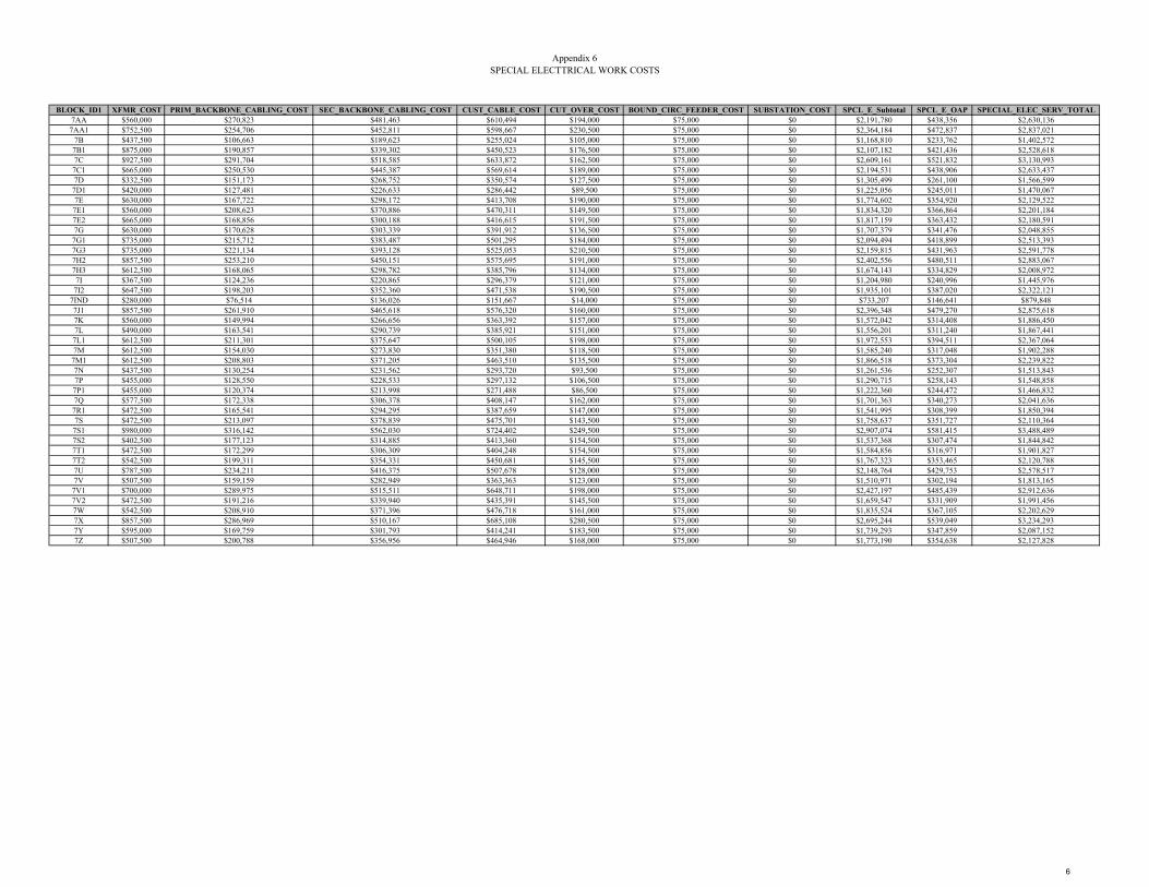
Appendix 6SPECIAL ELECTTRICAL WORK COSTS
BLOCK_ID1 XFMR_COST PRIM_BACKBONE_CABLING_COST SEC_BACKBONE_CABLING_COST CUST_CABLE_COST CUT_OVER_COST BOUND_CIRC_FEEDER_COST SUBSTATION_COST SPCL_E_Subtotal SPCL_E_OAP SPECIAL_ELEC_SERV_TOTAL7AA $560,000 $270,823 $481,463 $610,494 $194,000 $75,000 $0 $2,191,780 $438,356 $2,630,136
7AA1 $752,500 $254,706 $452,811 $598,667 $230,500 $75,000 $0 $2,364,184 $472,837 $2,837,0217B $437,500 $106,663 $189,623 $255,024 $105,000 $75,000 $0 $1,168,810 $233,762 $1,402,5727B1 $875,000 $190,857 $339,302 $450,523 $176,500 $75,000 $0 $2,107,182 $421,436 $2,528,6187C $927,500 $291,704 $518,585 $633,872 $162,500 $75,000 $0 $2,609,161 $521,832 $3,130,9937C1 $665,000 $250,530 $445,387 $569,614 $189,000 $75,000 $0 $2,194,531 $438,906 $2,633,4377D $332,500 $151,173 $268,752 $350,574 $127,500 $75,000 $0 $1,305,499 $261,100 $1,566,599
7D1 $420,000 $127,481 $226,633 $286,442 $89,500 $75,000 $0 $1,225,056 $245,011 $1,470,0677E $630,000 $167,722 $298,172 $413,708 $190,000 $75,000 $0 $1,774,602 $354,920 $2,129,5227E1 $560,000 $208,623 $370,886 $470,311 $149,500 $75,000 $0 $1,834,320 $366,864 $2,201,1847E2 $665,000 $168,856 $300,188 $416,615 $191,500 $75,000 $0 $1,817,159 $363,432 $2,180,5917G $630,000 $170,628 $303,339 $391,912 $136,500 $75,000 $0 $1,707,379 $341,476 $2,048,855
7G1 $735,000 $215,712 $383,487 $501,295 $184,000 $75,000 $0 $2,094,494 $418,899 $2,513,3937G3 $735,000 $221,134 $393,128 $525,053 $210,500 $75,000 $0 $2,159,815 $431,963 $2,591,7787H2 $857,500 $253,210 $450,151 $575,695 $191,000 $75,000 $0 $2,402,556 $480,511 $2,883,0677H3 $612,500 $168,065 $298,782 $385,796 $134,000 $75,000 $0 $1,674,143 $334,829 $2,008,9727I $367,500 $124,236 $220,865 $296,379 $121,000 $75,000 $0 $1,204,980 $240,996 $1,445,9767I2 $647,500 $198,203 $352,360 $471,538 $190,500 $75,000 $0 $1,935,101 $387,020 $2,322,121
7IND $280,000 $76,514 $136,026 $151,667 $14,000 $75,000 $0 $733,207 $146,641 $879,8487J1 $857,500 $261,910 $465,618 $576,320 $160,000 $75,000 $0 $2,396,348 $479,270 $2,875,6187K $560,000 $149,994 $266,656 $363,392 $157,000 $75,000 $0 $1,572,042 $314,408 $1,886,4507L $490,000 $163,541 $290,739 $385,921 $151,000 $75,000 $0 $1,556,201 $311,240 $1,867,4417L1 $612,500 $211,301 $375,647 $500,105 $198,000 $75,000 $0 $1,972,553 $394,511 $2,367,0647M $612,500 $154,030 $273,830 $351,380 $118,500 $75,000 $0 $1,585,240 $317,048 $1,902,288
7M1 $612,500 $208,803 $371,205 $463,510 $135,500 $75,000 $0 $1,866,518 $373,304 $2,239,8227N $437,500 $130,254 $231,562 $293,720 $93,500 $75,000 $0 $1,261,536 $252,307 $1,513,8437P $455,000 $128,550 $228,533 $297,132 $106,500 $75,000 $0 $1,290,715 $258,143 $1,548,858
7P1 $455,000 $120,374 $213,998 $271,488 $86,500 $75,000 $0 $1,222,360 $244,472 $1,466,8327Q $577,500 $172,338 $306,378 $408,147 $162,000 $75,000 $0 $1,701,363 $340,273 $2,041,6367R1 $472,500 $165,541 $294,295 $387,659 $147,000 $75,000 $0 $1,541,995 $308,399 $1,850,3947S $472,500 $213,097 $378,839 $475,701 $143,500 $75,000 $0 $1,758,637 $351,727 $2,110,364
7S1 $980,000 $316,142 $562,030 $724,402 $249,500 $75,000 $0 $2,907,074 $581,415 $3,488,4897S2 $402,500 $177,123 $314,885 $413,360 $154,500 $75,000 $0 $1,537,368 $307,474 $1,844,8427T1 $472,500 $172,299 $306,309 $404,248 $154,500 $75,000 $0 $1,584,856 $316,971 $1,901,8277T2 $542,500 $199,311 $354,331 $450,681 $145,500 $75,000 $0 $1,767,323 $353,465 $2,120,7887U $787,500 $234,211 $416,375 $507,678 $128,000 $75,000 $0 $2,148,764 $429,753 $2,578,5177V $507,500 $159,159 $282,949 $363,363 $123,000 $75,000 $0 $1,510,971 $302,194 $1,813,165
7V1 $700,000 $289,975 $515,511 $648,711 $198,000 $75,000 $0 $2,427,197 $485,439 $2,912,6367V2 $472,500 $191,216 $339,940 $435,391 $145,500 $75,000 $0 $1,659,547 $331,909 $1,991,4567W $542,500 $208,910 $371,396 $476,718 $161,000 $75,000 $0 $1,835,524 $367,105 $2,202,6297X $857,500 $286,969 $510,167 $685,108 $280,500 $75,000 $0 $2,695,244 $539,049 $3,234,2937Y $595,000 $169,759 $301,793 $414,241 $183,500 $75,000 $0 $1,739,293 $347,859 $2,087,1527Z $507,500 $200,788 $356,956 $464,946 $168,000 $75,000 $0 $1,773,190 $354,638 $2,127,828
6
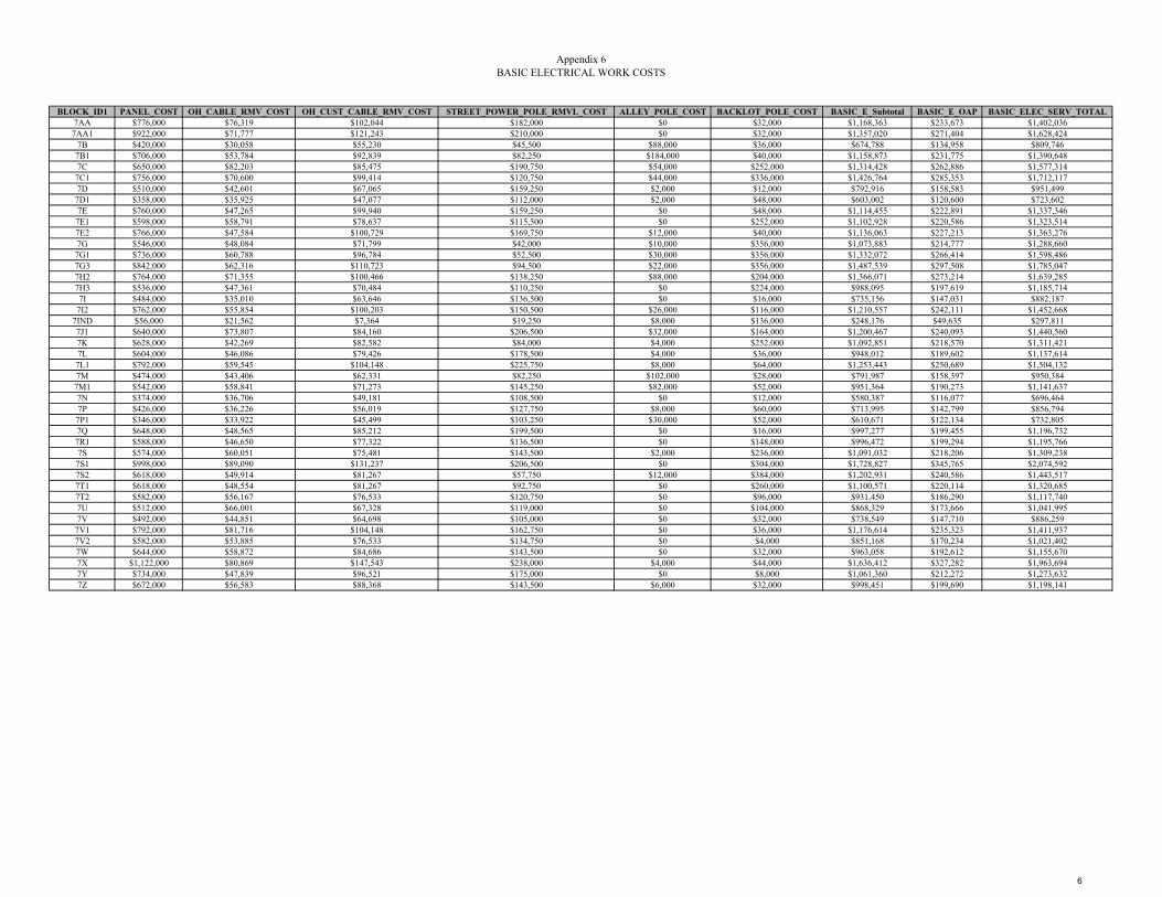
Appendix 6BASIC ELECTRICAL WORK COSTS
BLOCK_ID1 PANEL_COST OH_CABLE_RMV_COST OH_CUST_CABLE_RMV_COST STREET_POWER_POLE_RMVL_COST ALLEY_POLE_COST BACKLOT_POLE_COST BASIC_E_Subtotal BASIC_E_OAP BASIC_ELEC_SERV_TOTAL7AA $776,000 $76,319 $102,044 $182,000 $0 $32,000 $1,168,363 $233,673 $1,402,0367AA1 $922,000 $71,777 $121,243 $210,000 $0 $32,000 $1,357,020 $271,404 $1,628,424
7B $420,000 $30,058 $55,230 $45,500 $88,000 $36,000 $674,788 $134,958 $809,7467B1 $706,000 $53,784 $92,839 $82,250 $184,000 $40,000 $1,158,873 $231,775 $1,390,6487C $650,000 $82,203 $85,475 $190,750 $54,000 $252,000 $1,314,428 $262,886 $1,577,3147C1 $756,000 $70,600 $99,414 $120,750 $44,000 $336,000 $1,426,764 $285,353 $1,712,1177D $510,000 $42,601 $67,065 $159,250 $2,000 $12,000 $792,916 $158,583 $951,4997D1 $358,000 $35,925 $47,077 $112,000 $2,000 $48,000 $603,002 $120,600 $723,6027E $760,000 $47,265 $99,940 $159,250 $0 $48,000 $1,114,455 $222,891 $1,337,3467E1 $598,000 $58,791 $78,637 $115,500 $0 $252,000 $1,102,928 $220,586 $1,323,5147E2 $766,000 $47,584 $100,729 $169,750 $12,000 $40,000 $1,136,063 $227,213 $1,363,2767G $546,000 $48,084 $71,799 $42,000 $10,000 $356,000 $1,073,883 $214,777 $1,288,6607G1 $736,000 $60,788 $96,784 $52,500 $30,000 $356,000 $1,332,072 $266,414 $1,598,4867G3 $842,000 $62,316 $110,723 $94,500 $22,000 $356,000 $1,487,539 $297,508 $1,785,0477H2 $764,000 $71,355 $100,466 $138,250 $88,000 $204,000 $1,366,071 $273,214 $1,639,2857H3 $536,000 $47,361 $70,484 $110,250 $0 $224,000 $988,095 $197,619 $1,185,7147I $484,000 $35,010 $63,646 $136,500 $0 $16,000 $735,156 $147,031 $882,1877I2 $762,000 $55,854 $100,203 $150,500 $26,000 $116,000 $1,210,557 $242,111 $1,452,668
7IND $56,000 $21,562 $7,364 $19,250 $8,000 $136,000 $248,176 $49,635 $297,8117J1 $640,000 $73,807 $84,160 $206,500 $32,000 $164,000 $1,200,467 $240,093 $1,440,5607K $628,000 $42,269 $82,582 $84,000 $4,000 $252,000 $1,092,851 $218,570 $1,311,4217L $604,000 $46,086 $79,426 $178,500 $4,000 $36,000 $948,012 $189,602 $1,137,614
7L1 $792,000 $59,545 $104,148 $225,750 $8,000 $64,000 $1,253,443 $250,689 $1,504,1327M $474,000 $43,406 $62,331 $82,250 $102,000 $28,000 $791,987 $158,397 $950,384
7M1 $542,000 $58,841 $71,273 $145,250 $82,000 $52,000 $951,364 $190,273 $1,141,6377N $374,000 $36,706 $49,181 $108,500 $0 $12,000 $580,387 $116,077 $696,4647P $426,000 $36,226 $56,019 $127,750 $8,000 $60,000 $713,995 $142,799 $856,7947P1 $346,000 $33,922 $45,499 $103,250 $30,000 $52,000 $610,671 $122,134 $732,8057Q $648,000 $48,565 $85,212 $199,500 $0 $16,000 $997,277 $199,455 $1,196,7327R1 $588,000 $46,650 $77,322 $136,500 $0 $148,000 $996,472 $199,294 $1,195,7667S $574,000 $60,051 $75,481 $143,500 $2,000 $236,000 $1,091,032 $218,206 $1,309,2387S1 $998,000 $89,090 $131,237 $206,500 $0 $304,000 $1,728,827 $345,765 $2,074,5927S2 $618,000 $49,914 $81,267 $57,750 $12,000 $384,000 $1,202,931 $240,586 $1,443,5177T1 $618,000 $48,554 $81,267 $92,750 $0 $260,000 $1,100,571 $220,114 $1,320,6857T2 $582,000 $56,167 $76,533 $120,750 $0 $96,000 $931,450 $186,290 $1,117,7407U $512,000 $66,001 $67,328 $119,000 $0 $104,000 $868,329 $173,666 $1,041,9957V $492,000 $44,851 $64,698 $105,000 $0 $32,000 $738,549 $147,710 $886,2597V1 $792,000 $81,716 $104,148 $162,750 $0 $36,000 $1,176,614 $235,323 $1,411,9377V2 $582,000 $53,885 $76,533 $134,750 $0 $4,000 $851,168 $170,234 $1,021,4027W $644,000 $58,872 $84,686 $143,500 $0 $32,000 $963,058 $192,612 $1,155,6707X $1,122,000 $80,869 $147,543 $238,000 $4,000 $44,000 $1,636,412 $327,282 $1,963,6947Y $734,000 $47,839 $96,521 $175,000 $0 $8,000 $1,061,360 $212,272 $1,273,6327Z $672,000 $56,583 $88,368 $143,500 $6,000 $32,000 $998,451 $199,690 $1,198,141
6

UUP MASTER PLAN UPDATE – FACTORS AND METHOD
APPENDIX 6 DISTRICT 8

Appendix 6Updated 2009 Master Plan with Applied Current Algorithms
BLOCK_ID1 CIP_ID Council District INTERSECTIONS Backlot_Poles ALLEY_Poles OH_Poles XFMR_Count Meters P_Length ServiceDrop SUB_Count8A1 UU497 3 35 9 54 110 26 901 10,118.03 189 08D UU496 8 9 17 47 102 29 429 10,969.85 223 0
8D1 UU810 8 28 31 49 129 20 444 13,801.60 296 08E UU803 8 26 23 53 129 26 677 13,848.68 186 08H UU820 8 3 30 73 112 27 466 10,485.88 225 08I UU819 8 13 19 96 133 20 611 12,562.38 293 08J UU813 8 8 2 83 102 14 526 9,587.55 260 0
8J1 UU809 8 7 13 40 74 20 259 7,672.54 165 08J2 UU812 8 8 7 67 88 20 529 8,499.76 215 08K UU835 8 15 5 59 83 16 454 7,259.33 202 0
8K1 UU811 8 19 19 20 93 19 453 10,154.79 225 08L UU822 8 24 31 61 148 33 638 14,711.33 272 08M UU821 8 35 29 61 137 37 347 14,320.14 233 0
8M1 UU665 8 27 24 59 129 25 532 16,310.99 263 08N UU823 9 23 23 45 117 22 453 13,183.19 235 0
8N1 UU824 9 21 29 33 103 21 348 12,185.06 258 08O UU826 8 17 25 46 109 19 520 13,785.61 265 08P UU825 8 52 8 66 138 24 544 16,458.52 284 08Q UU827 8 20 18 3 114 34 383 15,039.51 187 08S UU314 8 28 14 0 99 23 350 14,185.32 349 08U UU666 8 20 19 0 89 28 304 14,031.96 304 0
8U1 UU828 8 18 19 0 121 23 340 13,475.20 316 08V UU829 8 22 17 0 102 21 365 15,027.37 349 08W UU831 8 11 18 0 86 17 399 9,642.90 87 08X UU832 8 20 33 0 123 26 407 14,442.82 170 0
8X1 UU830 8 10 81 0 146 23 280 15,823.00 140 0
13
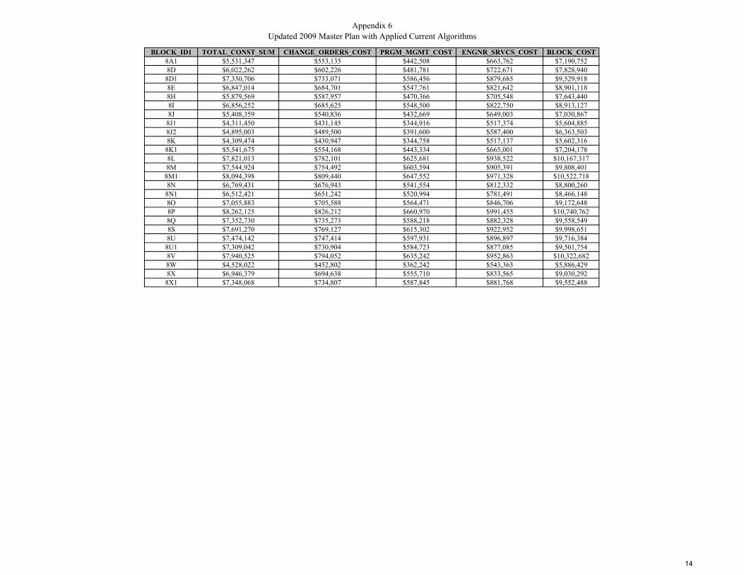
Appendix 6Updated 2009 Master Plan with Applied Current Algorithms
BLOCK_ID1 TOTAL_CONST_SUM CHANGE_ORDERS_COST PRGM_MGMT_COST ENGNR_SRVCS_COST BLOCK_COST8A1 $5,531,347 $553,135 $442,508 $663,762 $7,190,7528D $6,022,262 $602,226 $481,781 $722,671 $7,828,940
8D1 $7,330,706 $733,071 $586,456 $879,685 $9,529,9188E $6,847,014 $684,701 $547,761 $821,642 $8,901,1188H $5,879,569 $587,957 $470,366 $705,548 $7,643,4408I $6,856,252 $685,625 $548,500 $822,750 $8,913,1278J $5,408,359 $540,836 $432,669 $649,003 $7,030,867
8J1 $4,311,450 $431,145 $344,916 $517,374 $5,604,8858J2 $4,895,003 $489,500 $391,600 $587,400 $6,363,5038K $4,309,474 $430,947 $344,758 $517,137 $5,602,316
8K1 $5,541,675 $554,168 $443,334 $665,001 $7,204,1788L $7,821,013 $782,101 $625,681 $938,522 $10,167,3178M $7,544,924 $754,492 $603,594 $905,391 $9,808,401
8M1 $8,094,398 $809,440 $647,552 $971,328 $10,522,7188N $6,769,431 $676,943 $541,554 $812,332 $8,800,260
8N1 $6,512,421 $651,242 $520,994 $781,491 $8,466,1488O $7,055,883 $705,588 $564,471 $846,706 $9,172,6488P $8,262,125 $826,212 $660,970 $991,455 $10,740,7628Q $7,352,730 $735,273 $588,218 $882,328 $9,558,5498S $7,691,270 $769,127 $615,302 $922,952 $9,998,6518U $7,474,142 $747,414 $597,931 $896,897 $9,716,384
8U1 $7,309,042 $730,904 $584,723 $877,085 $9,501,7548V $7,940,525 $794,052 $635,242 $952,863 $10,322,6828W $4,528,022 $452,802 $362,242 $543,363 $5,886,4298X $6,946,379 $694,638 $555,710 $833,565 $9,030,292
8X1 $7,348,068 $734,807 $587,845 $881,768 $9,552,488
14
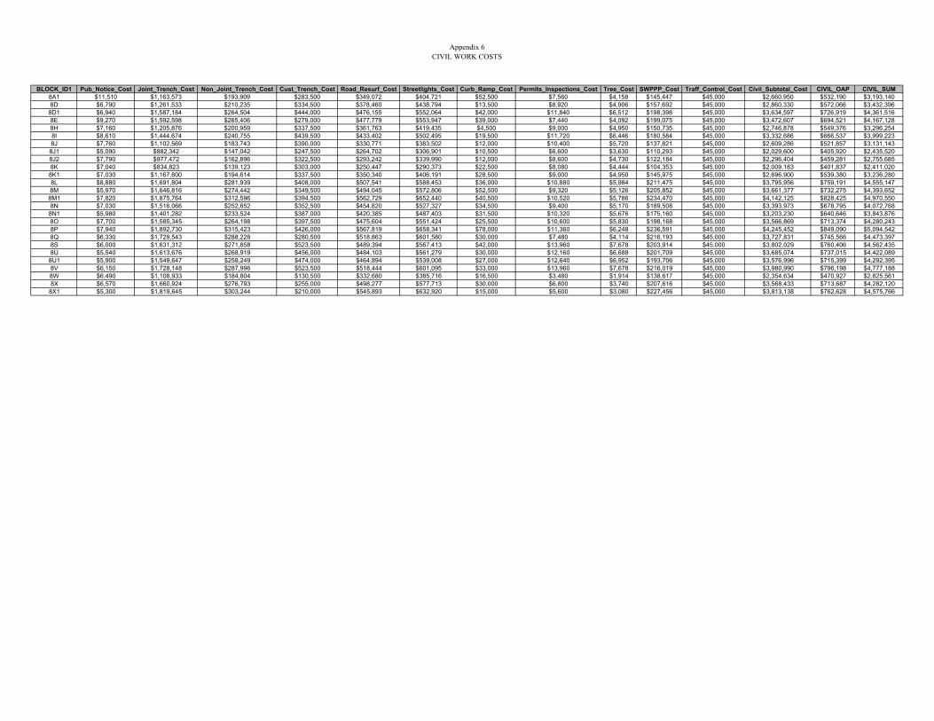
Appendix 6CIVIL WORK COSTS
BLOCK_ID1 Pub_Notice_Cost Joint_Trench_Cost Non_Joint_Trench_Cost Cust_Trench_Cost Road_Resurf_Cost Streetlights_Cost Curb_Ramp_Cost Permits_Inspections_Cost Tree_Cost SWPPP_Cost Traff_Control_Cost Civil_Subtotal_Cost CIVIL_OAP CIVIL_SUM8A1 $11,510 $1,163,573 $193,909 $283,500 $349,072 $404,721 $52,500 $7,560 $4,158 $145,447 $45,000 $2,660,950 $532,190 $3,193,1408D $6,790 $1,261,533 $210,235 $334,500 $378,460 $438,794 $13,500 $8,920 $4,906 $157,692 $45,000 $2,860,330 $572,066 $3,432,396
8D1 $6,940 $1,587,184 $264,504 $444,000 $476,155 $552,064 $42,000 $11,840 $6,512 $198,398 $45,000 $3,634,597 $726,919 $4,361,5168E $9,270 $1,592,598 $265,406 $279,000 $477,779 $553,947 $39,000 $7,440 $4,092 $199,075 $45,000 $3,472,607 $694,521 $4,167,1288H $7,160 $1,205,876 $200,959 $337,500 $361,763 $419,435 $4,500 $9,000 $4,950 $150,735 $45,000 $2,746,878 $549,376 $3,296,2548I $8,610 $1,444,674 $240,755 $439,500 $433,402 $502,495 $19,500 $11,720 $6,446 $180,584 $45,000 $3,332,686 $666,537 $3,999,2238J $7,760 $1,102,569 $183,743 $390,000 $330,771 $383,502 $12,000 $10,400 $5,720 $137,821 $45,000 $2,609,286 $521,857 $3,131,143
8J1 $5,090 $882,342 $147,042 $247,500 $264,702 $306,901 $10,500 $6,600 $3,630 $110,293 $45,000 $2,029,600 $405,920 $2,435,5208J2 $7,790 $977,472 $162,896 $322,500 $293,242 $339,990 $12,000 $8,600 $4,730 $122,184 $45,000 $2,296,404 $459,281 $2,755,6858K $7,040 $834,823 $139,123 $303,000 $250,447 $290,373 $22,500 $8,080 $4,444 $104,353 $45,000 $2,009,183 $401,837 $2,411,0208K1 $7,030 $1,167,800 $194,614 $337,500 $350,340 $406,191 $28,500 $9,000 $4,950 $145,975 $45,000 $2,696,900 $539,380 $3,236,2808L $8,880 $1,691,804 $281,939 $408,000 $507,541 $588,453 $36,000 $10,880 $5,984 $211,475 $45,000 $3,795,956 $759,191 $4,555,1478M $5,970 $1,646,816 $274,442 $349,500 $494,045 $572,806 $52,500 $9,320 $5,126 $205,852 $45,000 $3,661,377 $732,275 $4,393,6528M1 $7,820 $1,875,764 $312,596 $394,500 $562,729 $652,440 $40,500 $10,520 $5,786 $234,470 $45,000 $4,142,125 $828,425 $4,970,5508N $7,030 $1,516,066 $252,652 $352,500 $454,820 $527,327 $34,500 $9,400 $5,170 $189,508 $45,000 $3,393,973 $678,795 $4,072,768
8N1 $5,980 $1,401,282 $233,524 $387,000 $420,385 $487,403 $31,500 $10,320 $5,676 $175,160 $45,000 $3,203,230 $640,646 $3,843,8768O $7,700 $1,585,345 $264,198 $397,500 $475,604 $551,424 $25,500 $10,600 $5,830 $198,168 $45,000 $3,566,869 $713,374 $4,280,2438P $7,940 $1,892,730 $315,423 $426,000 $567,819 $658,341 $78,000 $11,360 $6,248 $236,591 $45,000 $4,245,452 $849,090 $5,094,5428Q $6,330 $1,729,543 $288,228 $280,500 $518,863 $601,580 $30,000 $7,480 $4,114 $216,193 $45,000 $3,727,831 $745,566 $4,473,3978S $6,000 $1,631,312 $271,858 $523,500 $489,394 $567,413 $42,000 $13,960 $7,678 $203,914 $45,000 $3,802,029 $760,406 $4,562,4358U $5,540 $1,613,676 $268,919 $456,000 $484,103 $561,279 $30,000 $12,160 $6,688 $201,709 $45,000 $3,685,074 $737,015 $4,422,089
8U1 $5,900 $1,549,647 $258,249 $474,000 $464,894 $539,008 $27,000 $12,640 $6,952 $193,706 $45,000 $3,576,996 $715,399 $4,292,3958V $6,150 $1,728,148 $287,996 $523,500 $518,444 $601,095 $33,000 $13,960 $7,678 $216,019 $45,000 $3,980,990 $796,198 $4,777,1888W $6,490 $1,108,933 $184,804 $130,500 $332,680 $385,716 $16,500 $3,480 $1,914 $138,617 $45,000 $2,354,634 $470,927 $2,825,5618X $6,570 $1,660,924 $276,793 $255,000 $498,277 $577,713 $30,000 $6,800 $3,740 $207,616 $45,000 $3,568,433 $713,687 $4,282,120
8X1 $5,300 $1,819,645 $303,244 $210,000 $545,893 $632,920 $15,000 $5,600 $3,080 $227,456 $45,000 $3,813,138 $762,628 $4,575,766
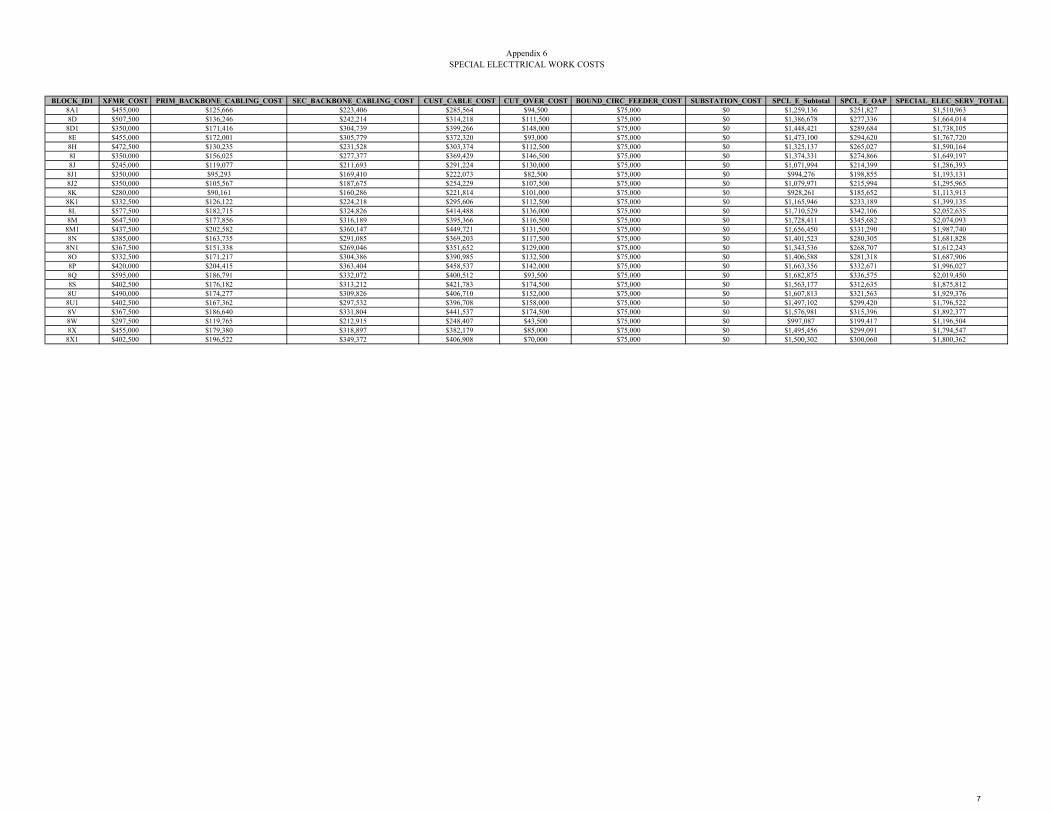
Appendix 6SPECIAL ELECTTRICAL WORK COSTS
BLOCK_ID1 XFMR_COST PRIM_BACKBONE_CABLING_COST SEC_BACKBONE_CABLING_COST CUST_CABLE_COST CUT_OVER_COST BOUND_CIRC_FEEDER_COST SUBSTATION_COST SPCL_E_Subtotal SPCL_E_OAP SPECIAL_ELEC_SERV_TOTAL8A1 $455,000 $125,666 $223,406 $285,564 $94,500 $75,000 $0 $1,259,136 $251,827 $1,510,9638D $507,500 $136,246 $242,214 $314,218 $111,500 $75,000 $0 $1,386,678 $277,336 $1,664,014
8D1 $350,000 $171,416 $304,739 $399,266 $148,000 $75,000 $0 $1,448,421 $289,684 $1,738,1058E $455,000 $172,001 $305,779 $372,320 $93,000 $75,000 $0 $1,473,100 $294,620 $1,767,7208H $472,500 $130,235 $231,528 $303,374 $112,500 $75,000 $0 $1,325,137 $265,027 $1,590,1648I $350,000 $156,025 $277,377 $369,429 $146,500 $75,000 $0 $1,374,331 $274,866 $1,649,1978J $245,000 $119,077 $211,693 $291,224 $130,000 $75,000 $0 $1,071,994 $214,399 $1,286,393
8J1 $350,000 $95,293 $169,410 $222,073 $82,500 $75,000 $0 $994,276 $198,855 $1,193,1318J2 $350,000 $105,567 $187,675 $254,229 $107,500 $75,000 $0 $1,079,971 $215,994 $1,295,9658K $280,000 $90,161 $160,286 $221,814 $101,000 $75,000 $0 $928,261 $185,652 $1,113,913
8K1 $332,500 $126,122 $224,218 $295,606 $112,500 $75,000 $0 $1,165,946 $233,189 $1,399,1358L $577,500 $182,715 $324,826 $414,488 $136,000 $75,000 $0 $1,710,529 $342,106 $2,052,6358M $647,500 $177,856 $316,189 $395,366 $116,500 $75,000 $0 $1,728,411 $345,682 $2,074,093
8M1 $437,500 $202,582 $360,147 $449,721 $131,500 $75,000 $0 $1,656,450 $331,290 $1,987,7408N $385,000 $163,735 $291,085 $369,203 $117,500 $75,000 $0 $1,401,523 $280,305 $1,681,828
8N1 $367,500 $151,338 $269,046 $351,652 $129,000 $75,000 $0 $1,343,536 $268,707 $1,612,2438O $332,500 $171,217 $304,386 $390,985 $132,500 $75,000 $0 $1,406,588 $281,318 $1,687,9068P $420,000 $204,415 $363,404 $458,537 $142,000 $75,000 $0 $1,663,356 $332,671 $1,996,0278Q $595,000 $186,791 $332,072 $400,512 $93,500 $75,000 $0 $1,682,875 $336,575 $2,019,4508S $402,500 $176,182 $313,212 $421,783 $174,500 $75,000 $0 $1,563,177 $312,635 $1,875,8128U $490,000 $174,277 $309,826 $406,710 $152,000 $75,000 $0 $1,607,813 $321,563 $1,929,376
8U1 $402,500 $167,362 $297,532 $396,708 $158,000 $75,000 $0 $1,497,102 $299,420 $1,796,5228V $367,500 $186,640 $331,804 $441,537 $174,500 $75,000 $0 $1,576,981 $315,396 $1,892,3778W $297,500 $119,765 $212,915 $248,407 $43,500 $75,000 $0 $997,087 $199,417 $1,196,5048X $455,000 $179,380 $318,897 $382,179 $85,000 $75,000 $0 $1,495,456 $299,091 $1,794,547
8X1 $402,500 $196,522 $349,372 $406,908 $70,000 $75,000 $0 $1,500,302 $300,060 $1,800,362
7

Appendix 6BASIC ELECTRICAL WORK COSTS
BLOCK_ID1 PANEL_COST OH_CABLE_RMV_COST OH_CUST_CABLE_RMV_COST STREET_POWER_POLE_RMVL_COST ALLEY_POLE_COST BACKLOT_POLE_COST BASIC_E_Subtotal BASIC_E_OAP BASIC_ELEC_SERV_TOTAL8A1 $378,000 $35,413 $49,707 $82,250 $108,000 $36,000 $689,370 $137,874 $827,2448D $446,000 $38,394 $58,649 $66,500 $94,000 $68,000 $771,543 $154,309 $925,8528D1 $592,000 $48,306 $77,848 $85,750 $98,000 $124,000 $1,025,904 $205,181 $1,231,0858E $372,000 $48,470 $48,918 $92,750 $106,000 $92,000 $760,138 $152,028 $912,1668H $450,000 $36,701 $59,175 $15,750 $146,000 $120,000 $827,626 $165,525 $993,1518I $586,000 $43,968 $77,059 $31,500 $192,000 $76,000 $1,006,527 $201,305 $1,207,8328J $520,000 $33,556 $68,380 $29,750 $166,000 $8,000 $825,686 $165,137 $990,8238J1 $330,000 $26,854 $43,395 $36,750 $80,000 $52,000 $568,999 $113,800 $682,7998J2 $430,000 $29,749 $56,545 $24,500 $134,000 $28,000 $702,794 $140,559 $843,3538K $404,000 $25,408 $53,126 $33,250 $118,000 $20,000 $653,784 $130,757 $784,5418K1 $450,000 $35,542 $59,175 $94,500 $40,000 $76,000 $755,217 $151,043 $906,2608L $544,000 $51,490 $71,536 $98,000 $122,000 $124,000 $1,011,026 $202,205 $1,213,2318M $466,000 $50,120 $61,279 $82,250 $122,000 $116,000 $897,649 $179,530 $1,077,179
8M1 $526,000 $57,088 $69,169 $80,500 $118,000 $96,000 $946,757 $189,351 $1,136,1088N $470,000 $46,141 $61,805 $85,750 $90,000 $92,000 $845,696 $169,139 $1,014,8358N1 $516,000 $42,648 $67,854 $71,750 $66,000 $116,000 $880,252 $176,050 $1,056,3028O $530,000 $48,250 $69,695 $66,500 $92,000 $100,000 $906,445 $181,289 $1,087,7348P $568,000 $57,605 $74,692 $112,000 $132,000 $32,000 $976,297 $195,259 $1,171,5568Q $374,000 $52,638 $49,181 $162,750 $6,000 $72,000 $716,569 $143,314 $859,8838S $698,000 $49,649 $91,787 $148,750 $0 $56,000 $1,044,186 $208,837 $1,253,0238U $608,000 $49,112 $79,952 $122,500 $0 $76,000 $935,564 $187,113 $1,122,677
8U1 $632,000 $47,163 $83,108 $178,500 $0 $76,000 $1,016,771 $203,354 $1,220,1258V $698,000 $52,596 $91,787 $148,750 $0 $68,000 $1,059,133 $211,827 $1,270,9608W $174,000 $33,750 $22,881 $119,000 $0 $72,000 $421,631 $84,326 $505,9578X $340,000 $50,550 $44,710 $157,500 $0 $132,000 $724,760 $144,952 $869,7128X1 $280,000 $55,380 $36,820 $113,750 $0 $324,000 $809,950 $161,990 $971,940
7

UUP MASTER PLAN UPDATE – FACTORS AND METHOD
APPENDIX 7 GIS TOOLS AND PROCESSES
Included herein is the complete description of the GIS information used in the development of updating the new Master Plan. This appendix describes in detail the steps taken for generating the Cost and Priority algorithms in ArcGIS.
Appendix 7 GIS Development Process
1
I. CITY GIS INFORMATION: A copy of the City UUPProjects_17May2016.shx file was created and renamed “MP2016_UUPProject” and saved under Master Plan.mdb personal geodatabase.
New files were created for Surcharge and Rule 20A projects from the MP2016_UUPProject file. Surcharge projects were separated out and renamed MP2016_SurchargeAll. Similarly, Rule 20A projects were also separated out and renamed MP2016_Rule20A.
II. SANDAG Information Parcels Data: The “PARCELS” data contains polygons representing current taxable parcels in San Diego County and some non-taxable parcels. The information was narrowed to the boundaries of the City of San Diego to make the information more manageable by use of the Geoprocessing “Clip” tool and named “PARCELS_SD_Subtype1_100ft_Dissol”. Only parcels classified as Subtype 1 denoting “Regular parcel with APN number” were used in the analysis. Additionally, parcels residing within open-space areas were removed from the analysis.
Land Use Data: The “LANDUSE_CURRENT” dataset contains information on existing land use created for use in the Regional Growth Forecast to distribute projected growth for the San Diego region to suitable subareas. The information was merged by classification using the geoprocessing “Dissolve” tool.
Roads Data: The “ROADS_ALL” data contains centerline segments for all roads (active and inactive, public and private, constructed or of record) within San Diego County. The information from SANDAG was based on data received from all official jurisdictions within the County (the County and 18 cities). Additionally, the data separates the City of San Diego’s streets into respective classifications such as Alley, Avenue, Boulevard, Bike Path, Bridge, etc.
Alley Data: This data was created by extracting selected information from the ROADS_ALL data and made into a separate dataset named “ROADS_ALL_Alley” to contain only those roads denoted as alleyways throughout the City of San Diego. The “Select by Attributes” tool was used within the ROADS_ALL attribute table to select only the records listed as “A” denoting Alleys within the SEGCLASS field.
Intersections Data: The “ROADS_INTERSECTIONS” data consists of points which represent intersection nodes at the end of individual road segments in the SanGIS ROADS_ALL layer. Only the Intersection Type code of “I” was used which denotes the ‘Normal’ Intersection of 3 or more segments. The Type Code defines why the road segment is terminated at that point.
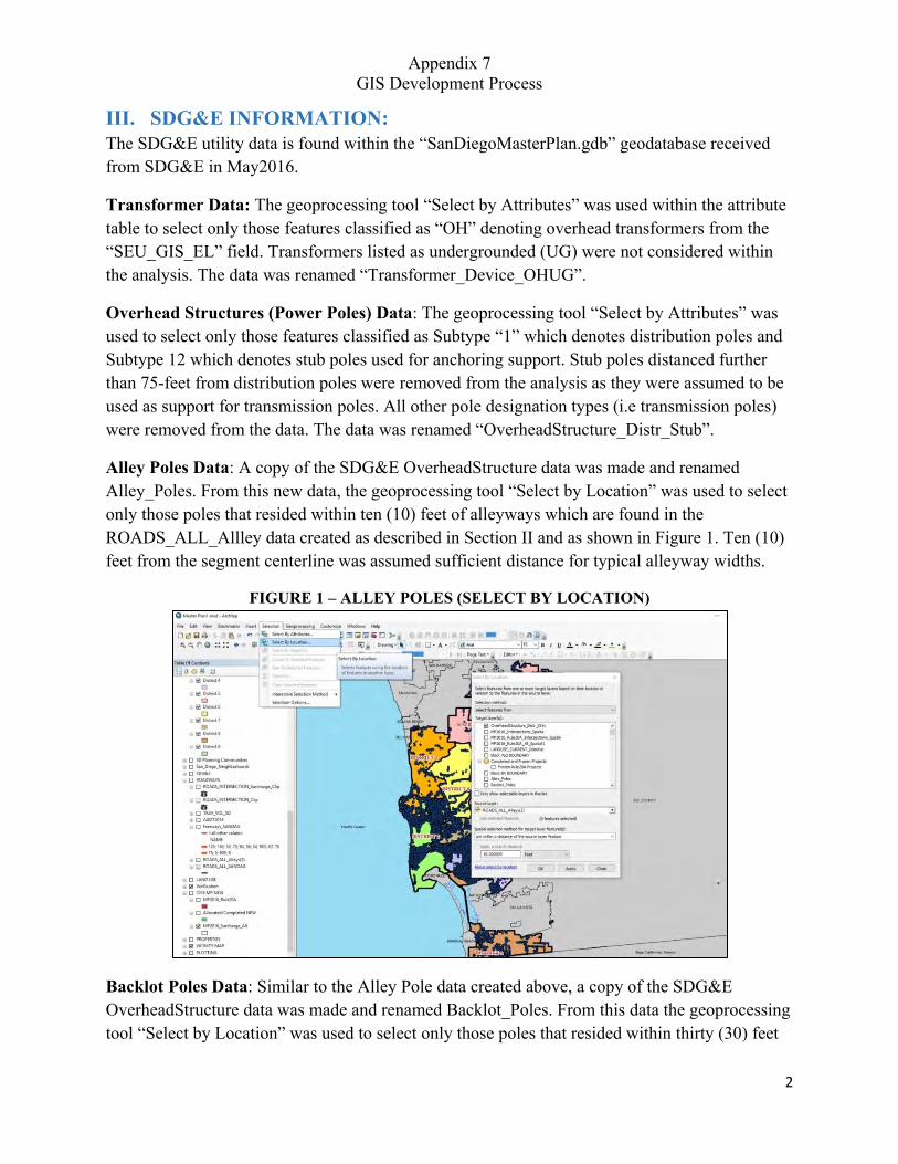
Appendix 7 GIS Development Process
2
III. SDG&E INFORMATION: The SDG&E utility data is found within the “SanDiegoMasterPlan.gdb” geodatabase received from SDG&E in May2016.
Transformer Data: The geoprocessing tool “Select by Attributes” was used within the attribute table to select only those features classified as “OH” denoting overhead transformers from the “SEU_GIS_EL” field. Transformers listed as undergrounded (UG) were not considered within the analysis. The data was renamed “Transformer_Device_OHUG”.
Overhead Structures (Power Poles) Data: The geoprocessing tool “Select by Attributes” was used to select only those features classified as Subtype “1” which denotes distribution poles and Subtype 12 which denotes stub poles used for anchoring support. Stub poles distanced further than 75-feet from distribution poles were removed from the analysis as they were assumed to be used as support for transmission poles. All other pole designation types (i.e transmission poles) were removed from the data. The data was renamed “OverheadStructure_Distr_Stub”.
Alley Poles Data: A copy of the SDG&E OverheadStructure data was made and renamed Alley_Poles. From this new data, the geoprocessing tool “Select by Location” was used to select only those poles that resided within ten (10) feet of alleyways which are found in the ROADS_ALL_Allley data created as described in Section II and as shown in Figure 1. Ten (10) feet from the segment centerline was assumed sufficient distance for typical alleyway widths.
FIGURE 1 – ALLEY POLES (SELECT BY LOCATION)
Backlot Poles Data: Similar to the Alley Pole data created above, a copy of the SDG&E OverheadStructure data was made and renamed Backlot_Poles. From this data the geoprocessing tool “Select by Location” was used to select only those poles that resided within thirty (30) feet
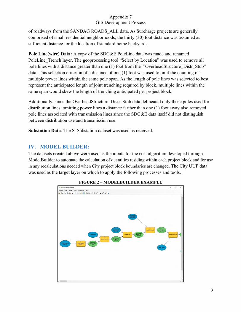
Appendix 7 GIS Development Process
3
of roadways from the SANDAG ROADS_ALL data. As Surcharge projects are generally comprised of small residential neighborhoods, the thirty (30) foot distance was assumed as sufficient distance for the location of standard home backyards.
Pole Line(wire) Data: A copy of the SDG&E PoleLine data was made and renamed PoleLine_Trench layer. The geoprocessing tool “Select by Location” was used to remove all pole lines with a distance greater than one (1) foot from the ”OverheadStructure_Distr_Stub” data. This selection criterion of a distance of one (1) foot was used to omit the counting of multiple power lines within the same pole span. As the length of pole lines was selected to best represent the anticipated length of joint trenching required by block, multiple lines within the same span would skew the length of trenching anticipated per project block.
Additionally, since the OverheadStructure_Distr_Stub data delineated only those poles used for distribution lines, omitting power lines a distance farther than one (1) foot away also removed pole lines associated with transmission lines since the SDG&E data itself did not distinguish between distribution use and transmission use.
Substation Data: The S_Substation dataset was used as received.
IV. MODEL BUILDER: The datasets created above were used as the inputs for the cost algorithm developed through ModelBuilder to automate the calculation of quantities residing within each project block and for use in any recalculations needed when City project block boundaries are changed. The City UUP data was used as the target layer on which to apply the following processes and tools.
FIGURE 2 – MODELBUILDER EXAMPLE
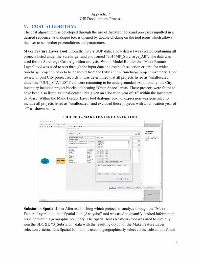
Appendix 7 GIS Development Process
4
V. COST ALGORITHM: The cost algorithm was developed through the use of ArcMap tools and processes inputted in a desired sequence. A dialogue box is opened by double clicking on the tool icons which allows the user to set further preconditions and parameters.
Make Feature Layer Tool: From the City’s UUP data, a new dataset was created containing all projects listed under the Surcharge fund and named “2016MP_Surcharge_All”. The data was used for the Surcharge Cost Algorithm analysis. Within Model Builder the “Make Feature Layer” tool was used to sort through the input data and establish selection criteria for which Surcharge project blocks to be analyzed from the City’s entire Surcharge project inventory. Upon review of past City project records, it was determined that all projects listed as “unallocated” under the “UUC_STATUS” field were remaining to be undergrounded. Additionally, the City inventory included project blocks delineating “Open Space” areas. These projects were found to have been also listed as “unallocated” but given an allocation year of “0” within the inventory database. Within the Make Feature Layer tool dialogue box, an expression was generated to include all projects listed as “unallocated” and excluded those projects with an allocation year of “0” as shown below.
FIGURE 3 – MAKE FEATURE LAYER TOOL
Substation Spatial Join: After establishing which projects to analyze through the “Make Feature Layer” tool, the “Spatial Join (Analysis)” tool was used to quantify desired information residing within a geographic boundary. The Spatial Join (Analysis) tool was used to spatially join the SDG&E “S_Substaion” data with the resulting output of the Make Feature Layer selection criteria. This Spatial Join tool is used to geographically select all the substations found
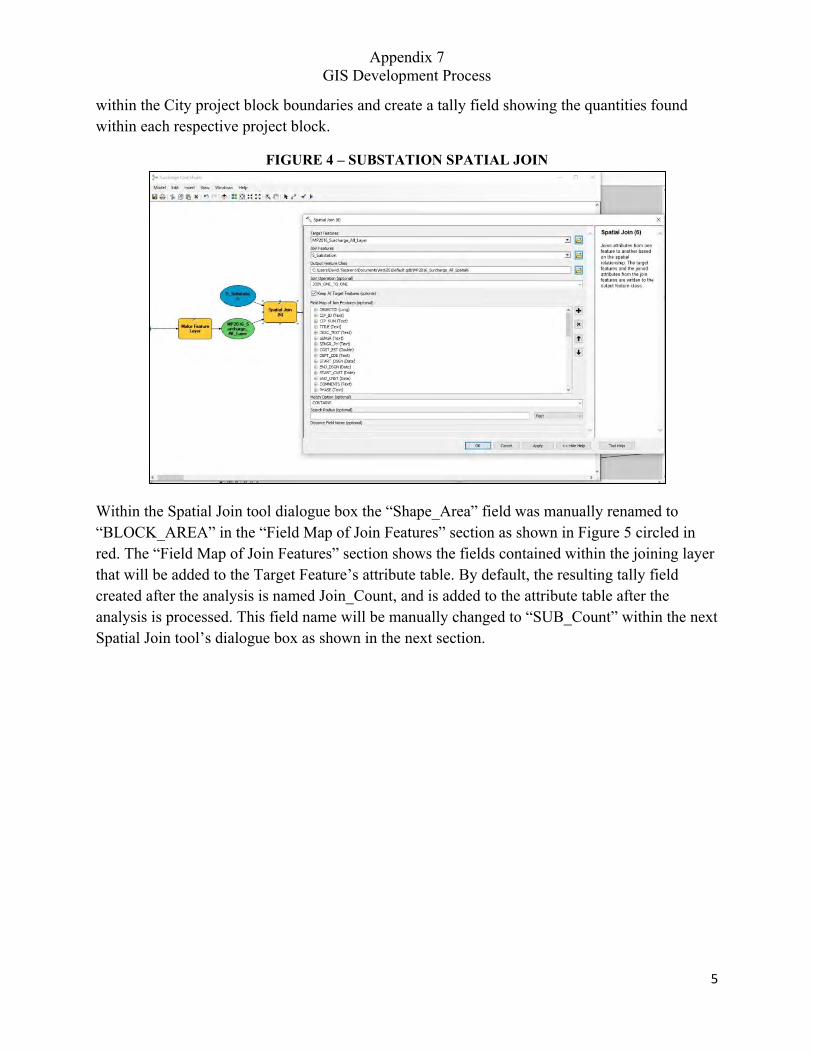
Appendix 7 GIS Development Process
5
within the City project block boundaries and create a tally field showing the quantities found within each respective project block.
FIGURE 4 – SUBSTATION SPATIAL JOIN
Within the Spatial Join tool dialogue box the “Shape_Area” field was manually renamed to “BLOCK_AREA” in the “Field Map of Join Features” section as shown in Figure 5 circled in red. The “Field Map of Join Features” section shows the fields contained within the joining layer that will be added to the Target Feature’s attribute table. By default, the resulting tally field created after the analysis is named Join_Count, and is added to the attribute table after the analysis is processed. This field name will be manually changed to “SUB_Count” within the next Spatial Join tool’s dialogue box as shown in the next section.
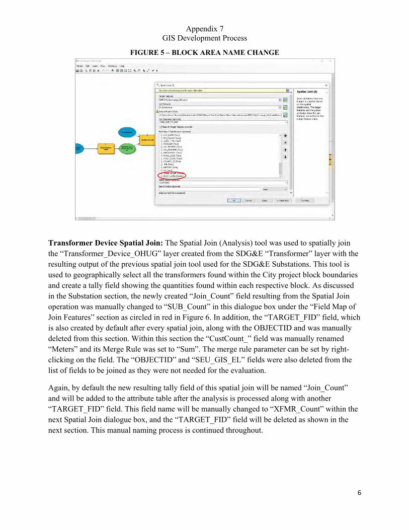
Appendix 7 GIS Development Process
6
FIGURE 5 – BLOCK AREA NAME CHANGE
Transformer Device Spatial Join: The Spatial Join (Analysis) tool was used to spatially join the “Transformer_Device_OHUG” layer created from the SDG&E “Transformer” layer with the resulting output of the previous spatial join tool used for the SDG&E Substations. This tool is used to geographically select all the transformers found within the City project block boundaries and create a tally field showing the quantities found within each respective block. As discussed in the Substation section, the newly created “Join_Count” field resulting from the Spatial Join operation was manually changed to “SUB_Count” in this dialogue box under the “Field Map of Join Features” section as circled in red in Figure 6. In addition, the “TARGET_FID” field, which is also created by default after every spatial join, along with the OBJECTID and was manually deleted from this section. Within this section the “CustCount_” field was manually renamed “Meters” and its Merge Rule was set to “Sum”. The merge rule parameter can be set by right-clicking on the field. The “OBJECTID” and “SEU_GIS_EL” fields were also deleted from the list of fields to be joined as they were not needed for the evaluation.
Again, by default the new resulting tally field of this spatial join will be named “Join_Count” and will be added to the attribute table after the analysis is processed along with another “TARGET_FID” field. This field name will be manually changed to “XFMR_Count” within the next Spatial Join dialogue box, and the “TARGET_FID” field will be deleted as shown in the next section. This manual naming process is continued throughout.
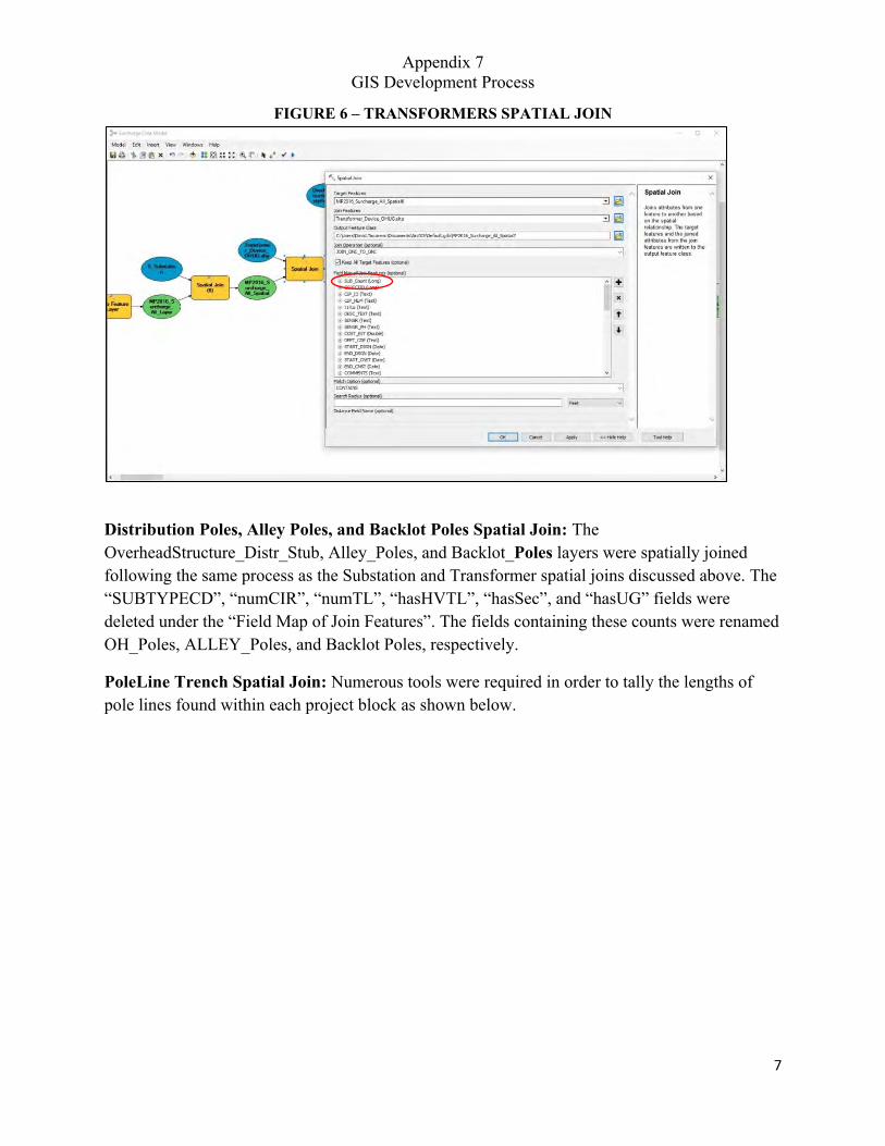
Appendix 7 GIS Development Process
7
FIGURE 6 – TRANSFORMERS SPATIAL JOIN
Distribution Poles, Alley Poles, and Backlot Poles Spatial Join: The OverheadStructure_Distr_Stub, Alley_Poles, and Backlot_Poles layers were spatially joined following the same process as the Substation and Transformer spatial joins discussed above. The “SUBTYPECD”, “numCIR”, “numTL”, “hasHVTL”, “hasSec”, and “hasUG” fields were deleted under the “Field Map of Join Features”. The fields containing these counts were renamed OH_Poles, ALLEY_Poles, and Backlot Poles, respectively.
PoleLine Trench Spatial Join: Numerous tools were required in order to tally the lengths of pole lines found within each project block as shown below.
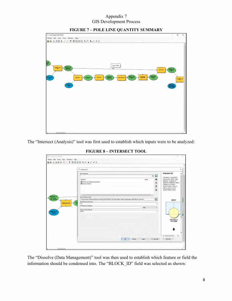
Appendix 7 GIS Development Process
8
FIGURE 7 – POLE LINE QUANTITY SUMMARY
The “Intersect (Analysis)” tool was first used to establish which inputs were to be analyzed:
FIGURE 8 – INTERSECT TOOL
The “Dissolve (Data Management)” tool was then used to establish which feature or field the information should be condensed into. The “BLOCK_ID” field was selected as shown:
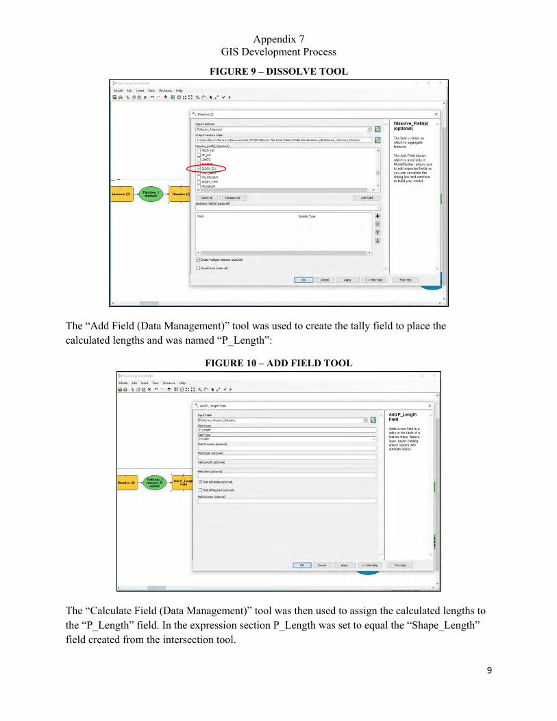
Appendix 7 GIS Development Process
9
FIGURE 9 – DISSOLVE TOOL
The “Add Field (Data Management)” tool was used to create the tally field to place the calculated lengths and was named “P_Length”:
FIGURE 10 – ADD FIELD TOOL
The “Calculate Field (Data Management)” tool was then used to assign the calculated lengths to the “P_Length” field. In the expression section P_Length was set to equal the “Shape_Length” field created from the intersection tool.

Appendix 7 GIS Development Process
10
FIGURE 11 – POLE LINE CALCULATE FIELD TOOL
Once, the pole line lengths have been populated by Project Block ID, the information was combined to the original attribute table using the “Join Field (Data Management)” tool.
FIGURE 12 – JOIN FIELD TOOL
Parcels Spatial Join: The Spatial Join (Analysis) tool was used to spatially join the “PARCELS_SD_Subtype1_100ft_Dissol” layer created as described in Section II with the resulting output of the previous Pole Line merge and Join Field tool. This tool is used to geographically select all the assumed remaining Parcels requiring undergrounding conversions found within the City project block boundaries and tally quantities by respective project block.
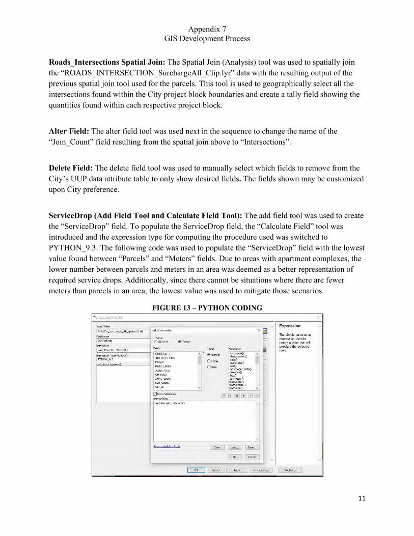
Appendix 7 GIS Development Process
11
Roads_Intersections Spatial Join: The Spatial Join (Analysis) tool was used to spatially join the “ROADS_INTERSECTION_SurchargeAll_Clip.lyr” data with the resulting output of the previous spatial join tool used for the parcels. This tool is used to geographically select all the intersections found within the City project block boundaries and create a tally field showing the quantities found within each respective project block.
Alter Field: The alter field tool was used next in the sequence to change the name of the “Join_Count” field resulting from the spatial join above to “Intersections”.
Delete Field: The delete field tool was used to manually select which fields to remove from the City’s UUP data attribute table to only show desired fields. The fields shown may be customized upon City preference.
ServiceDrop (Add Field Tool and Calculate Field Tool): The add field tool was used to create the “ServiceDrop” field. To populate the ServiceDrop field, the “Calculate Field” tool was introduced and the expression type for computing the procedure used was switched to PYTHON_9.3. The following code was used to populate the “ServiceDrop” field with the lowest value found between “Parcels” and “Meters” fields. Due to areas with apartment complexes, the lower number between parcels and meters in an area was deemed as a better representation of required service drops. Additionally, since there cannot be situations where there are fewer meters than parcels in an area, the lowest value was used to mitigate those scenarios.
FIGURE 13 – PYTHON CODING
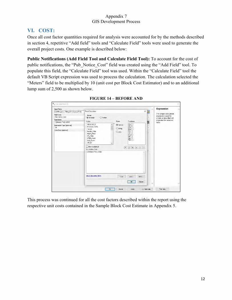
Appendix 7 GIS Development Process
12
VI. COST: Once all cost factor quantities required for analysis were accounted for by the methods described in section 4, repetitive “Add field” tools and “Calculate Field” tools were used to generate the overall project costs. One example is described below:
Public Notifications (Add Field Tool and Calculate Field Tool): To account for the cost of public notifications, the “Pub_Notice_Cost” field was created using the “Add Field” tool. To populate this field, the “Calculate Field” tool was used. Within the “Calculate Field” tool the default VB Script expression was used to process the calculation. The calculation selected the “Meters” field to be multiplied by 10 (unit cost per Block Cost Estimator) and to an additional lump sum of 2,500 as shown below.
FIGURE 14 – BEFORE AND
This process was continued for all the cost factors described within the report using the respective unit costs contained in the Sample Block Cost Estimate in Appendix 5.
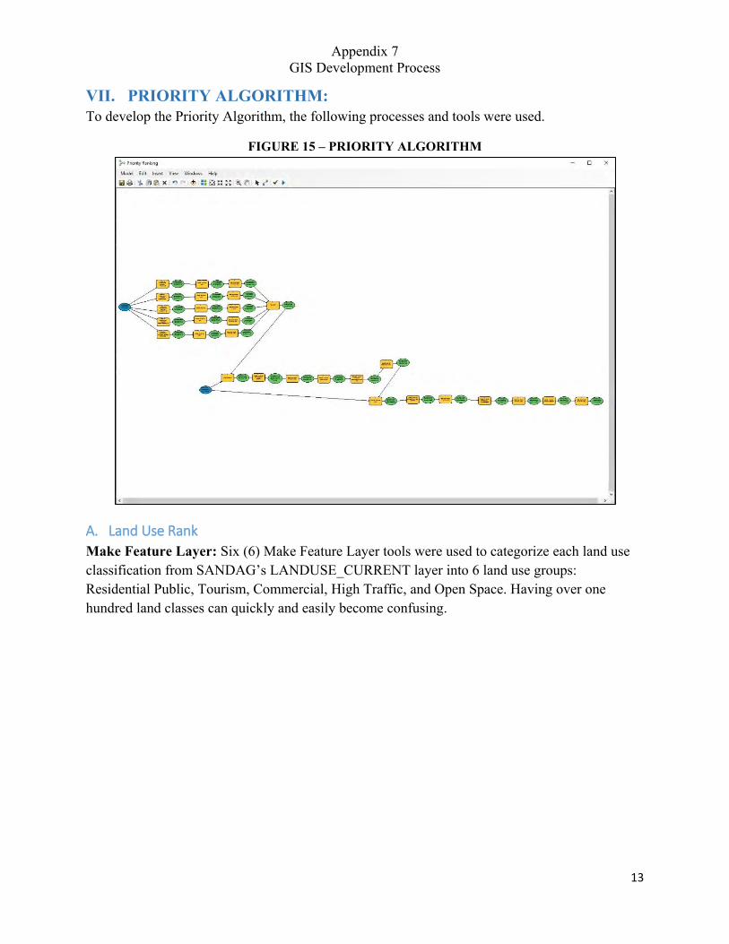
Appendix 7 GIS Development Process
13
VII. PRIORITY ALGORITHM: To develop the Priority Algorithm, the following processes and tools were used.
FIGURE 15 – PRIORITY ALGORITHM
A. Land Use Rank
Make Feature Layer: Six (6) Make Feature Layer tools were used to categorize each land use classification from SANDAG’s LANDUSE_CURRENT layer into 6 land use groups: Residential Public, Tourism, Commercial, High Traffic, and Open Space. Having over one hundred land classes can quickly and easily become confusing.
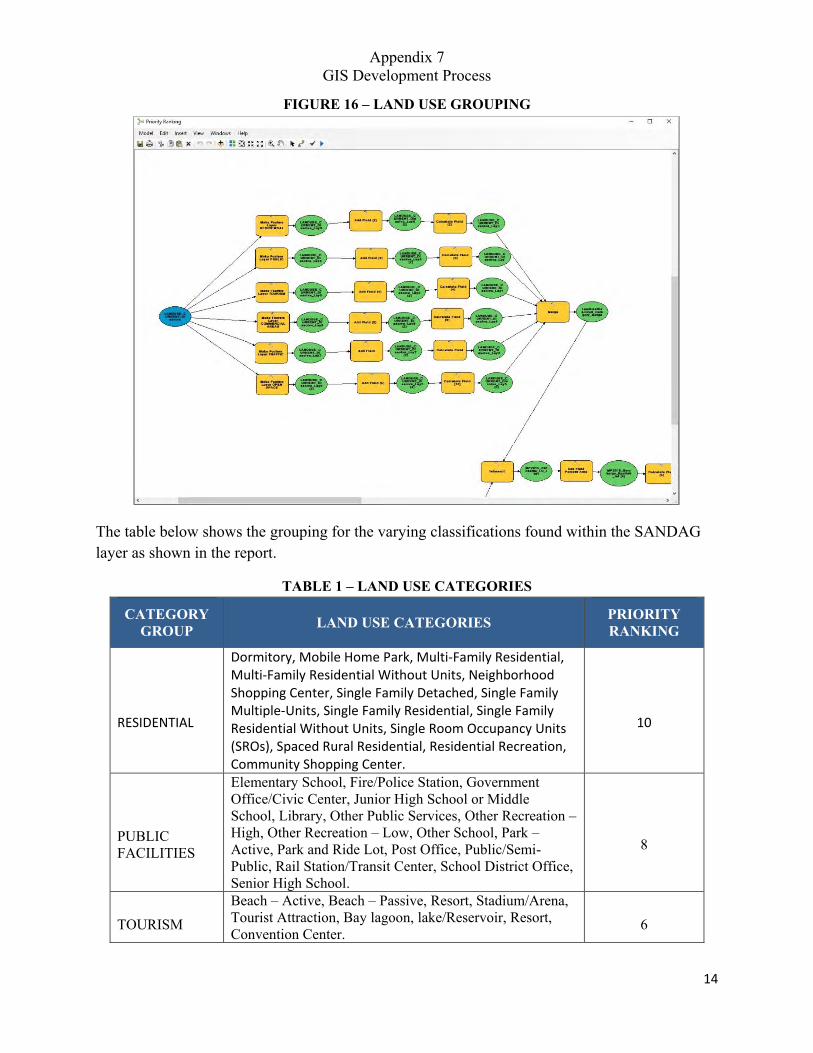
Appendix 7 GIS Development Process
14
FIGURE 16 – LAND USE GROUPING
The table below shows the grouping for the varying classifications found within the SANDAG layer as shown in the report.
TABLE 1 – LAND USE CATEGORIES
CATEGORY GROUP LAND USE CATEGORIES PRIORITY
RANKING
RESIDENTIAL
Dormitory, Mobile Home Park, Multi-Family Residential, Multi-Family Residential Without Units, Neighborhood Shopping Center, Single Family Detached, Single Family Multiple-Units, Single Family Residential, Single Family Residential Without Units, Single Room Occupancy Units (SROs), Spaced Rural Residential, Residential Recreation, Community Shopping Center.
10
PUBLIC FACILITIES
Elementary School, Fire/Police Station, Government Office/Civic Center, Junior High School or Middle School, Library, Other Public Services, Other Recreation – High, Other Recreation – Low, Other School, Park – Active, Park and Ride Lot, Post Office, Public/Semi-Public, Rail Station/Transit Center, School District Office, Senior High School.
8
TOURISM Beach – Active, Beach – Passive, Resort, Stadium/Arena, Tourist Attraction, Bay lagoon, lake/Reservoir, Resort, Convention Center.
6
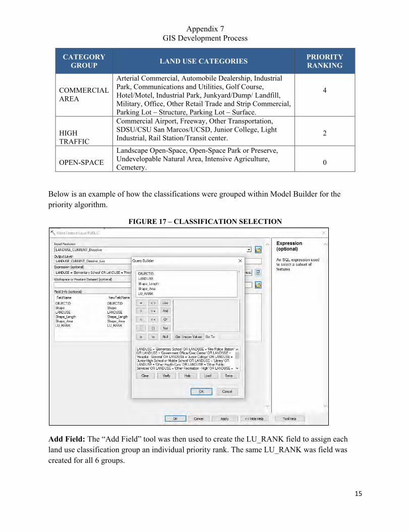
Appendix 7 GIS Development Process
15
CATEGORY GROUP LAND USE CATEGORIES PRIORITY
RANKING
COMMERCIAL AREA
Arterial Commercial, Automobile Dealership, Industrial Park, Communications and Utilities, Golf Course, Hotel/Motel, Industrial Park, Junkyard/Dump/ Landfill, Military, Office, Other Retail Trade and Strip Commercial, Parking Lot – Structure, Parking Lot – Surface.
4
HIGH TRAFFIC
Commercial Airport, Freeway, Other Transportation, SDSU/CSU San Marcos/UCSD, Junior College, Light Industrial, Rail Station/Transit center. 2
OPEN-SPACE Landscape Open-Space, Open-Space Park or Preserve, Undevelopable Natural Area, Intensive Agriculture, Cemetery. 0
Below is an example of how the classifications were grouped within Model Builder for the priority algorithm.
FIGURE 17 – CLASSIFICATION SELECTION
Add Field: The “Add Field” tool was then used to create the LU_RANK field to assign each land use classification group an individual priority rank. The same LU_RANK was field was created for all 6 groups.
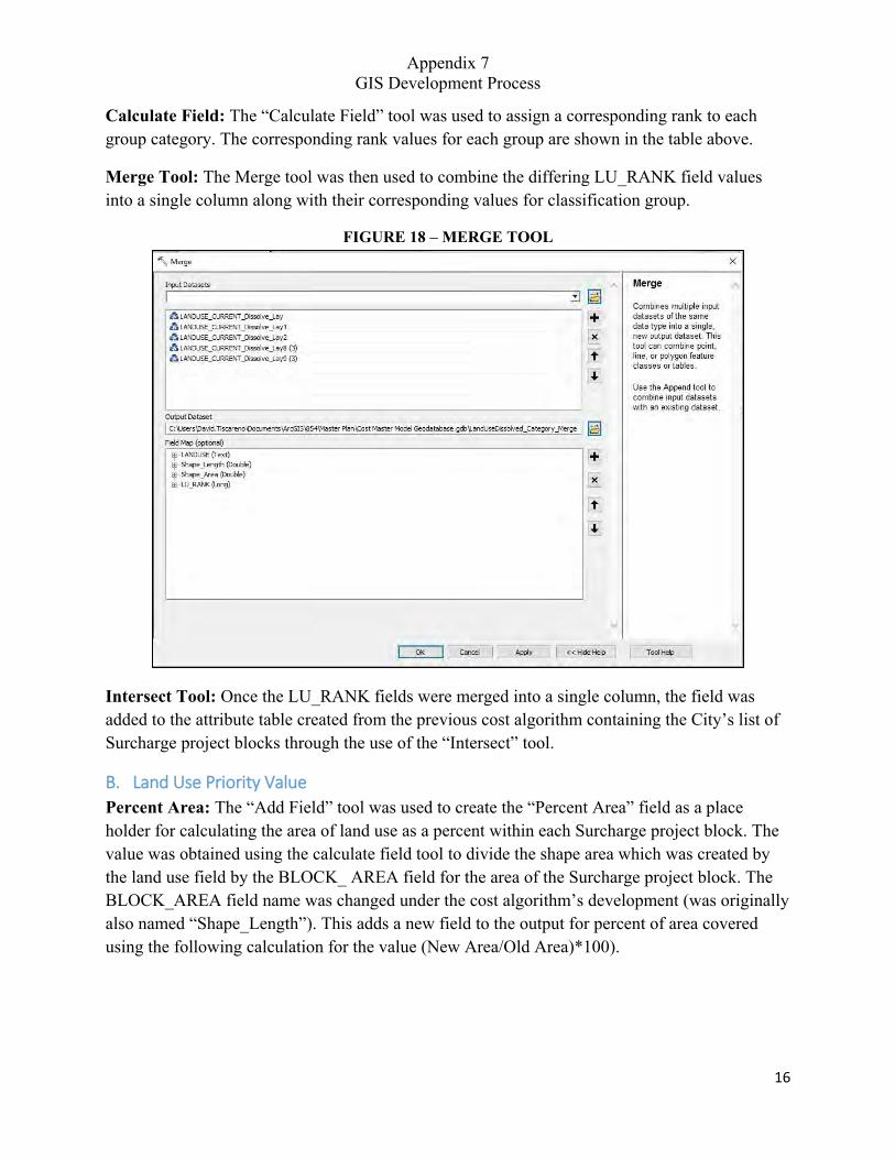
Appendix 7 GIS Development Process
16
Calculate Field: The “Calculate Field” tool was used to assign a corresponding rank to each group category. The corresponding rank values for each group are shown in the table above.
Merge Tool: The Merge tool was then used to combine the differing LU_RANK field values into a single column along with their corresponding values for classification group.
FIGURE 18 – MERGE TOOL
Intersect Tool: Once the LU_RANK fields were merged into a single column, the field was added to the attribute table created from the previous cost algorithm containing the City’s list of Surcharge project blocks through the use of the “Intersect” tool.
B. Land Use Priority Value
Percent Area: The “Add Field” tool was used to create the “Percent Area” field as a place holder for calculating the area of land use as a percent within each Surcharge project block. The value was obtained using the calculate field tool to divide the shape area which was created by the land use field by the BLOCK_ AREA field for the area of the Surcharge project block. The BLOCK_AREA field name was changed under the cost algorithm’s development (was originally also named “Shape_Length”). This adds a new field to the output for percent of area covered using the following calculation for the value (New Area/Old Area)*100).
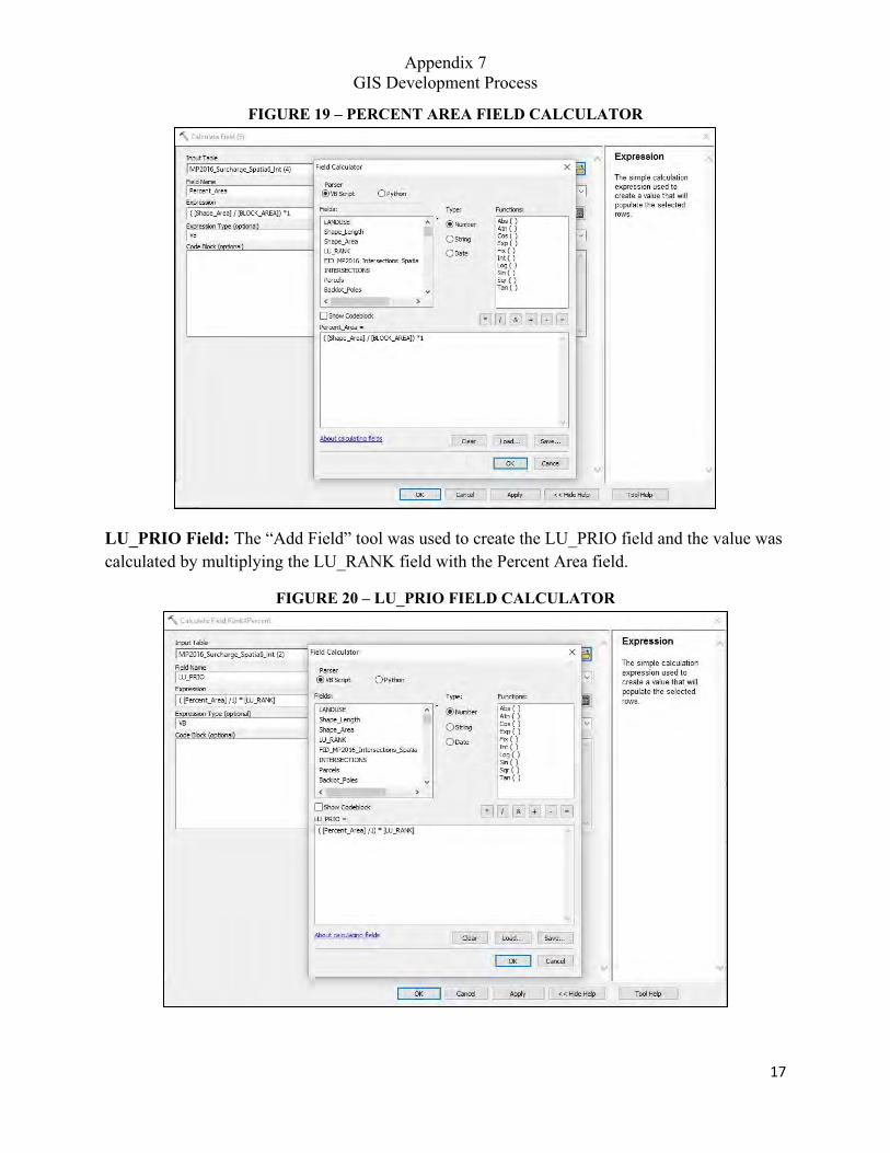
Appendix 7 GIS Development Process
17
FIGURE 19 – PERCENT AREA FIELD CALCULATOR
LU_PRIO Field: The “Add Field” tool was used to create the LU_PRIO field and the value was calculated by multiplying the LU_RANK field with the Percent Area field.
FIGURE 20 – LU_PRIO FIELD CALCULATOR
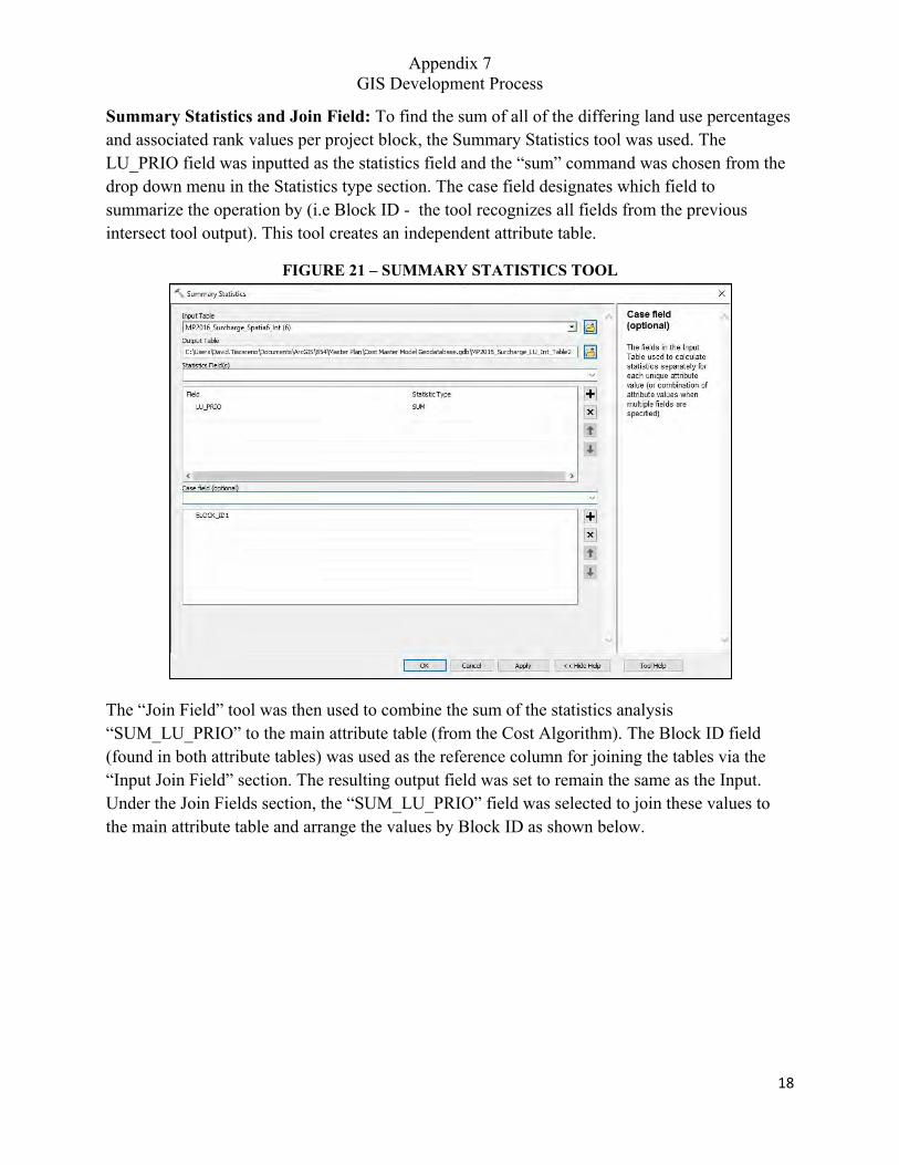
Appendix 7 GIS Development Process
18
Summary Statistics and Join Field: To find the sum of all of the differing land use percentages and associated rank values per project block, the Summary Statistics tool was used. The LU_PRIO field was inputted as the statistics field and the “sum” command was chosen from the drop down menu in the Statistics type section. The case field designates which field to summarize the operation by (i.e Block ID - the tool recognizes all fields from the previous intersect tool output). This tool creates an independent attribute table.
FIGURE 21 – SUMMARY STATISTICS TOOL
The “Join Field” tool was then used to combine the sum of the statistics analysis “SUM_LU_PRIO” to the main attribute table (from the Cost Algorithm). The Block ID field (found in both attribute tables) was used as the reference column for joining the tables via the “Input Join Field” section. The resulting output field was set to remain the same as the Input. Under the Join Fields section, the “SUM_LU_PRIO” field was selected to join these values to the main attribute table and arrange the values by Block ID as shown below.
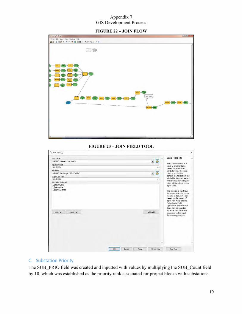
Appendix 7 GIS Development Process
19
FIGURE 22 – JOIN FLOW
FIGURE 23 – JOIN FIELD TOOL
C. Substation Priority
The SUB_PRIO field was created and inputted with values by multiplying the SUB_Count field by 10, which was established as the priority rank associated for project blocks with substations.
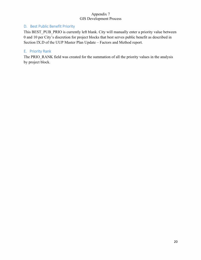
Appendix 7 GIS Development Process
20
D. Best Public Benefit Priority
This BEST_PUB_PRIO is currently left blank. City will manually enter a priority value between 0 and 10 per City’s discretion for project blocks that best serves public benefit as described in Section IX.D of the UUP Master Plan Update – Factors and Method report.
E. Priority Rank
The PRIO_RANK field was created for the summation of all the priority values in the analysis by project block.
UUP MASTER PLAN UPDATE – FACTORS AND METHOD
APPENDIX 8 CITY OF SAN DIEGO SANDAG GIS
WAREHOUSE DATA
Included herein is the complete SANDAG GIS data information used in updating the new Utility Undergrounding Master Plan’s development.
SANDAG
TABLE OF CONTENTS
SECTION 1 – ADDESS_APN
SECTION 2 – COASTLINE
SECTION 3 – COUNCIL_DISTRICTS
SECTION 4 – FREEWAYS
SECTION 5 – HARBOR_BAY
SECTION 6 – LANDUSE_CURRENT
SECTION 7 – MAJOR_ROADS
SECTION 8 – MUNICIPAL_BOUNDARIES
SECTION 9 – PARCELS
SECTION 10 – RESOURCE_CONSERVATION_AREAS
SECTION 11 – ROADS_ALL
SECTION 12 – ROADS_INTERSECTION
SECTION 13 – STATE_WITH_COUNTY_BOUNDARIES
SECTION 14 – TOURIST_ATTRACTIONS
SECTION 15 – VICINITY

UUP MASTER PLAN UPDATE – FACTORS AND METHOD
SECTION 1 ADDRESS_APN
ADDRESS_APN
TagsAddresses, Parcel Address, SITUS Address, Assessor Parcel Number (APN), San Diego County
Summary:
Feature Type: Point
Number of Records: 1156525
Publication Date: 2015-12-01
Date of Data (Temporal Period Extent): 2015-12-01
Extent: Publication date
Extent in Longitude Latitude
North 33.510378
South 32.530595
Extent in the item's coordinate system
North 2129332.531345
South 1775442.363798
Description:
This dataset comprises SITUS address points (as opposed to owner or mailing addresses) for jurisdictions within the County of San Diego. Addresses include the corresponding Assessor Parcel Number (APN), address type, placement location, and US National Grid (USNG) value.
West -117.592906 East -116.081303
West 6152307.000053 East 6613087.990891
SITUS address points within the County of San Diego with corresponding Assessor Parcel Number (APN). The dataset includes address fields, x y coordinates, US National Grid coordinates, address type, and placement location (e.g. structure or centroid) for each feature. These are SITUS addresses. That is, they refer to the officially assigned address for a tax parcel. They may not be the house or mailing address or the owner address of the property.Address points in this layer are derived from two sources: The County of San Diego's Assessor's Office Master Property Record (MPR) and address points provided to SanGIS by the addressing
Page 1 of 7
Credits:
Use Limitation:
Topics and Keywords
Topic Categories: Location Planning Cadastral Structure
Themes:
Address, Assessor Parcel Number (APN), location, SITUS
Places:
California, County of San Diego, Carlsbad, Coronado, Chula Vista, Del Mar, El Cajon, Encinitas, Escondido, Imperial Beach, Lemon Grove, La Mesa, National City, Oceanside, Poway, San Diego, San Marcos, Solana Beach, Santee, Vista
Resource Details:
Status: On GoingType: VectorUpdate Frequency: WeeklyNext Update: 2014-08-29
authority in each jurisdiction (18 cities and the County of San Diego). Not all jurisdictions provide address points to SanGIS. SanGIS attempts to eliminate duplicate points so that only one address-APN combination is present for each parcel (although there may be multiple addresses on the property). Priority is given to the SanGIS address point over the one derived from the MPR under the assumption that the points from the addressing authority of each jurisidiction is more current. Address point source is indicated in the ASOURCE field.SanGIS is in the process of updating address point locations to more accurately reflect the SITUS address. Where possible, address points are being located to the primary structure on the property. This is a long term, ongoing effort and many points have not yet been relocated. Address points are tagged with a placement location of 'Review' until they are reviewed and edited accordingly. The location of the address point is indicated in the PLACEMENT_LOCATION attribute. All points derived from the Assessor's MPR are placed at the centroid of the parcel.Refer to field descriptions under Resources for a full listing.
SanGIS using legal recorded data provided by the County Assessors Office and addressing authorities from the 18 incorporated cities in the County.
Data is generalized and created for use in regional projects. Please refer to SanGIS data end user use agreement and disclaimer which is available at the following: http://www.sangis.org/Legal_Notice.htm.The address layer is not expected to be a complete inventory of every address in the County. Data is available only as provided to SanGIS. Addresses are SITUS address points - not structure or owner or mailing addresses. Apartment addresses are not included. Most condominium and mobile home addresses are not resolved to the actual structure location.
Page 2 of 7
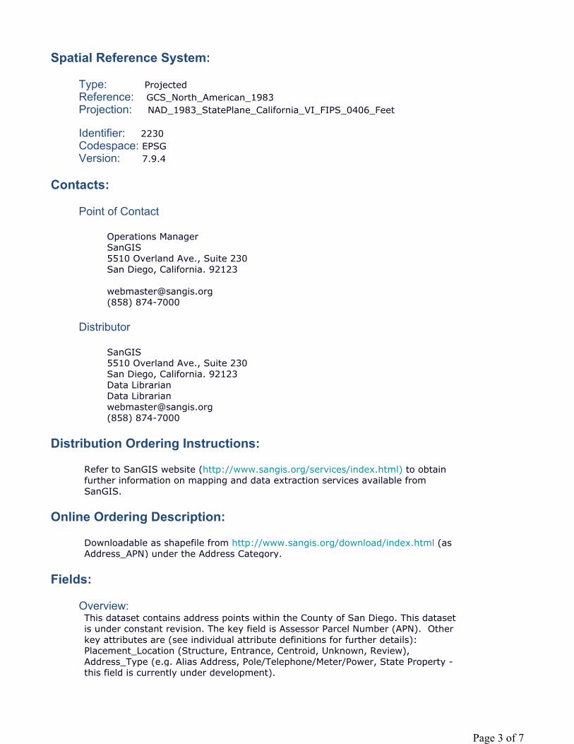
Spatial Reference System:
Type: ProjectedReference: GCS_North_American_1983Projection: NAD_1983_StatePlane_California_VI_FIPS_0406_Feet
Identifier: 2230Codespace: EPSGVersion: 7.9.4
Contacts:
Point of Contact
Operations ManagerSanGIS5510 Overland Ave., Suite 230San Diego, California. 92123
[email protected](858) 874-7000
Distributor
SanGIS5510 Overland Ave., Suite 230San Diego, California. 92123Data LibrarianData [email protected](858) 874-7000
Distribution Ordering Instructions:
Online Ordering Description:
Fields:
Overview:
Refer to SanGIS website (http://www.sangis.org/services/index.html) to obtain further information on mapping and data extraction services available from SanGIS.
Downloadable as shapefile from http://www.sangis.org/download/index.html (as Address_APN) under the Address Category.
This dataset contains address points within the County of San Diego. This dataset is under constant revision. The key field is Assessor Parcel Number (APN). Other key attributes are (see individual attribute definitions for further details): Placement_Location (Structure, Entrance, Centroid, Unknown, Review), Address_Type (e.g. Alias Address, Pole/Telephone/Meter/Power, State Property -this field is currently under development).
Page 3 of 7
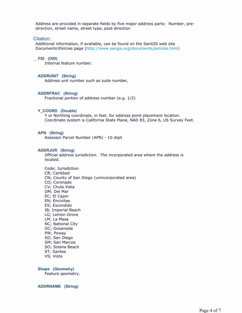
Citation:
__FID (OID)
ADDRUNIT (String)
ADDRFRAC (String)
Y_COORD (Double)
APN (String)
ADDRJUR (String)
Shape (Geometry)
ADDRNAME (String)
Address are provided in separate fields by five major address parts: Number, pre-direction, street name, street type, post-direction
Additional information, if available, can be found on the SanGIS web site Documents\Policies page (http://www.sangis.org/documents/policies.html)
Internal feature number.
Address unit number such as suite number,
Fractional portion of address number (e.g. 1/2)
Y or Northing coordinate, in feet, for address point placement location. Coordinate system is California State Plane, NAD 83, Zone 6, US Survey Feet.
Assessor Parcel Number (APN) - 10 digit
Official address jurisdiction. The incorporated area where the address is located.
Code; JurisdictionCB; CarlsbadCN; County of San Diego (unincorporated area)CO; CoronadoCV; Chula VistaDM; Del MarEC; El CajonEN; EncinitasES; EscondidoIB; Imperial BeachLG; Lemon GroveLM; La MesaNC; National CityOC; OceansidePW; PowaySD; San DiegoSM; San MarcosSO; Solana BeachST; SanteeVS; Vista
Feature geometry.
Page 4 of 7
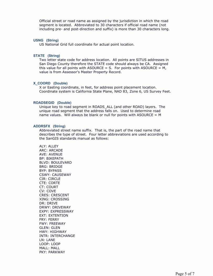
USNG (String)
STATE (String)
X_COORD (Double)
ROADSEGID (Double)
ADDRSFX (String)
Official street or road name as assigned by the jurisdiction in which the road segment is located. Abbreviated to 30 characters if official road name (not including pre- and post-direction and suffix) is more than 30 characters long.
US National Grid full coordinate for actual point location.
Two letter state code for address location. All points are SITUS addresses in San Diego County therefore the STATE code should always be CA. Assigned this value for all points with ASOURCE = S. For points with ASOURCE = M, value is from Assessor's Master Property Record.
X or Easting coordinate, in feet, for address point placement location. Coordinate system is California State Plane, NAD 83, Zone 6, US Survey Feet.
Unique key to road segment in ROADS_ALL (and other ROAD) layers. The unique road segment that the address falls on. Used to determine road name values. Will always be blank or null for points with ASOURCE = M
Abbreviated street name suffix. That is, the part of the road name that describes the type of street. Four letter abbreviations are used according to the SanGIS standards manual as follows:
ALY: ALLEYARC: ARCADEAVE: AVENUEBP: BIKEPATHBLVD: BOULEVARDBRG: BRIDGEBYP: BYPASSCSWY: CAUSEWAYCIR: CIRCLECTE: CORTECT: COURTCV: COVE CRES: CRESCENTXING: CROSSINGDR: DRIVEDRWY: DRIVEWAYEXPY: EXPRESSWAYEXT: EXTENTIONFRY: FERRYFWY: FREEWAYGLEN: GLENHWY: HIGHWAYINTR: INTERCHANGELN: LANELOOP: LOOPMALL: MALLPKY: PARKWAY
Page 5 of 7
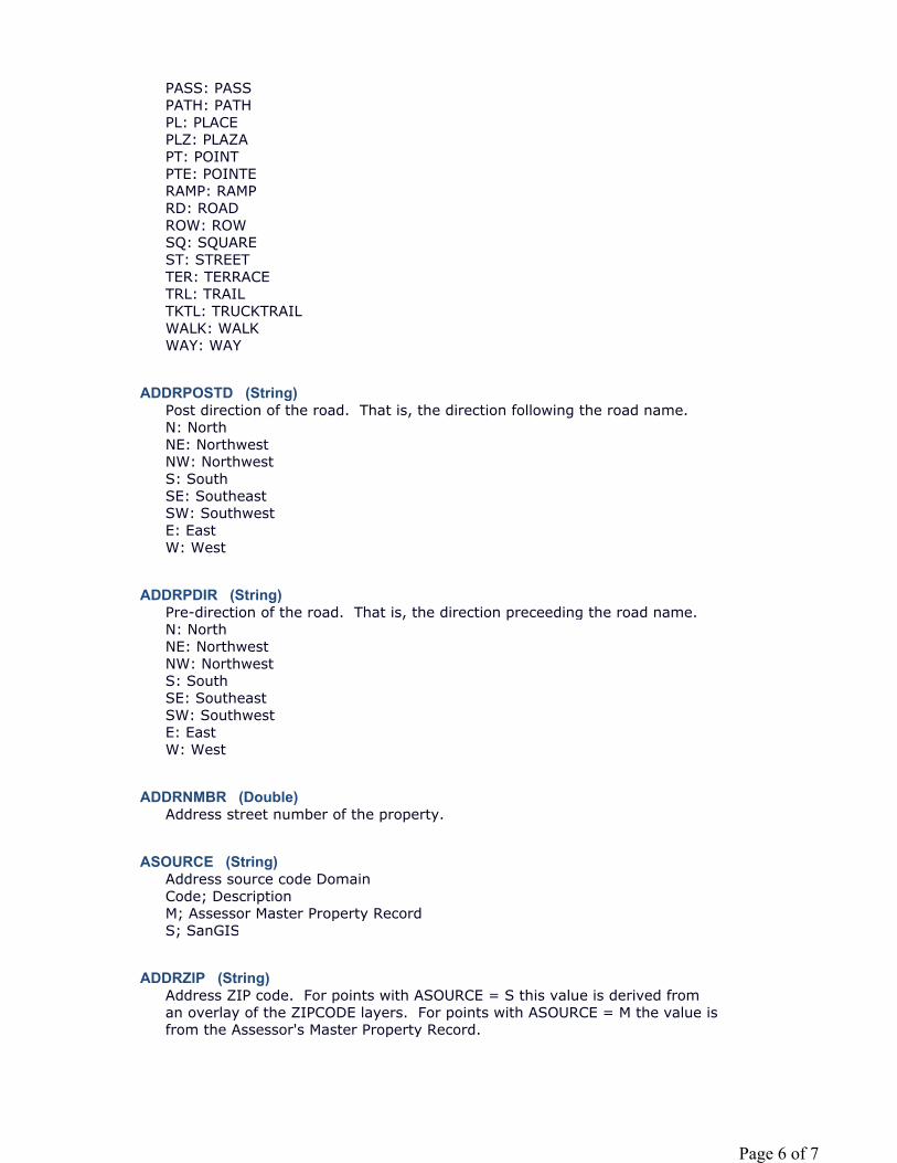
ADDRPOSTD (String)
ADDRPDIR (String)
ADDRNMBR (Double)
ASOURCE (String)
ADDRZIP (String)
PASS: PASSPATH: PATHPL: PLACEPLZ: PLAZAPT: POINTPTE: POINTERAMP: RAMPRD: ROADROW: ROWSQ: SQUAREST: STREETTER: TERRACETRL: TRAILTKTL: TRUCKTRAILWALK: WALKWAY: WAY
Post direction of the road. That is, the direction following the road name.N: NorthNE: NorthwestNW: NorthwestS: SouthSE: SoutheastSW: SouthwestE: EastW: West
Pre-direction of the road. That is, the direction preceeding the road name.N: NorthNE: NorthwestNW: NorthwestS: SouthSE: SoutheastSW: SouthwestE: EastW: West
Address street number of the property.
Address source code DomainCode; DescriptionM; Assessor Master Property RecordS; SanGIS
Address ZIP code. For points with ASOURCE = S this value is derived from an overlay of the ZIPCODE layers. For points with ASOURCE = M the value is from the Assessor's Master Property Record.
Page 6 of 7
COMMUNITY (String)
PLACEMENT_ (String)
PARCELID (Double) ADDRESS_TY (String)
Metadata Last Update: 2015-12-01Regional GIS Data Warehouse (RGDW) Publication Stylesheet 1.4
The common (but not necessarily the official) name of the community encompassed by the given zip code. The name of the post office associated with the given zip code. For points with ASOURCE = S, this is retrieved from the post office name in the ZIPCODE layer. For ASOURCE = M points the name comes from the Master Property Recrod.
PLACEMENT_LOCATIONPlacement location domain.Code; DescriptionS; StructureE; EntranceC; CentroidU; UnknownR; Review
NOTE: Points are shown with code = R until they have been visually checked for placement location. Most points with code = R are at parcel centroid until moved.
All points with ASOURCE = M will be located at parcel centroids.
ADDRESS_TYPEAddress Type DomainCode; DescriptionA; ATM, Automatic Teller MachineB; Comfort StationC; Cable TVD; SD Unified Port Dist TidelandsE; Elec. Meter, Pedestal, Temp SvF; Parks and RecreationG; Federal Property, CaltransH; Fire DepartmentI; Irrigation System; MeterJ; County PropertyK; KioskL; Stop Light, Street LightM; State Property, CaltransP; Pacbel Equip, Sub Station, etcQ; Police DepartmentR; Retaining Wall, Crib WallS; SignT; Pole, Telephone, Meter, PowerV; Other City DepartmentsX; Alias Address
Page 7 of 7

UUP MASTER PLAN UPDATE – FACTORS AND METHOD
SECTION 2 COASTLINE
coast
TagsThere are no tags for this item.
Summary: There is no summary for this item.
Feature Type: Line
Number of Records: 3
Publication Date: Date not provided by data owner.
Date of Data (Temporal Period Extent): Date not provided by data owner.
Extent:
Extent in Longitude Latitude
North 34.465954
South 30.909211
Extent in the item's coordinate system
North 2477097.500000
South 1200000.000000
Description:
West -119.770189 East -116.299816
West 5500000.000000 East 6546038.000000
There is no description for this item.
Credits:There are no credits for this item.
Use Limitation:There are no access and use limitations for this item.
Resource Details:
Page 1 of 2
4/21/2015file:///C:/Users/lwedley/AppData/Local/Temp/arcB634/tmp84A1.tmp.htm
Status: Not specifiedType: VectorUpdate Frequency: Not specifiedNext Update: Not specified
Spatial Reference System:
Type: ProjectedReference: GCS_North_American_1983Projection: NAD_1983_StatePlane_California_VI_FIPS_0406_Feet
Identifier: 2230Codespace: EPSGVersion: 7.11.2
Contacts:
Point of Contact Not specified
Fields:
__FID (OID)
Shape (Geometry)
SD (SmallInteger)
Metadata Last Update: 2015-04-21Regional GIS Data Warehouse (RGDW) Publication Stylesheet 1.4
Internal feature number.
Feature geometry.
Page 2 of 2
4/21/2015file:///C:/Users/lwedley/AppData/Local/Temp/arcB634/tmp84A1.tmp.htm

UUP MASTER PLAN UPDATE – FACTORS AND METHOD
SECTION 3 COUNCIL_DISTRICTS
Council_Districts
TagsCity of San Diego, Council District
Summary:
Feature Type: Polygon
Number of Records: 9
Publication Date: 2015-01-15
Date of Data (Temporal Period Extent):
City of San Diego Council Districts Boundaries (adopted August 25, 2011). Commencing in the year following the year in which the national decennial census is taken under the direction of the United States Congress at the beginning of each decade, the Redistricting Commission shall adopt plans that redistrict the City into nine (9) Council districts designated by numbers 1 to 9 inclusive.
Date not provided by data owner.
Extent: publication date
Extent in Longitude Latitude
North 33.114842
South 32.533548
Extent in the item's coordinate system
North 1986043.899943
South 1775474.017278
Description:
West -117.285640 East -116.901637
West 6244554.959914 East 6360824.055459
On August 25, 2011, the Redistricting Commission of the City of San Diego voted 7-0 to adopt the Final Redistricting Plan, which specifies the boundaries of districts for San Diego City Council. The Final Plan complies with the redistricting criteria and legal requirements of San Diego City Charter sections 5 and 5.1; the U.S. Constitution; the federal Voting Rights Act of 1965; and related cases and statutes. The Redistricting Commission also added a 9th Council District, as
Page 1 of 3
4/3/2015file:///C:/Users/lwedley/AppData/Local/Temp/arcC9D4/tmp5C86.tmp.htm
Credits:
Use Limitation:
Topics and Keywords
Topic Categories: Boundaries Location
Themes:
Council District
Places:
City of San Diego
Resource Details:
Status: CompletedType: VectorUpdate Frequency: Not specifiedNext Update: Not specified
Spatial Reference System:
Type: ProjectedReference: GCS_North_American_1983Projection: NAD_1983_StatePlane_California_VI_FIPS_0406_Feet
Identifier: 2230Codespace: EPSGVersion: 7.11.2
Contacts:
Point of Contact
City of San Diego Redistricting CommissionCity of San Diego Redistricting Commission
directed by the voters of the City of San Diego in a Charter amendment enacted in 2010. The Redistricting Commission of the City of San Diego is vested with sole and exclusive authority to adopt plans that specify the boundaries of districts for San Diego City Council. San Diego City Charter sections 5 and 5.1 were enacted by the voters in 1992 to create an independent Redistricting Commission to draw City Council districts in compliance with the law.
City of San Diego
None
Page 2 of 3
4/3/2015file:///C:/Users/lwedley/AppData/Local/Temp/arcC9D4/tmp5C86.tmp.htm
[email protected](619) 533-3060
Distributor
City of San DiegoMichael KleinGIS [email protected]
Distribution Ordering Instructions:
Fields:
Overview:
Citation:
__FID (OID)
OBJECTID (Double)
Shape (Geometry)
NAME (String) PHONE (String) WEBSITE (String) PERIMETER (Double) DISTRICT (Double)
AREA (Double) SHAPE_AREA (Double)
SHAPE_LEN (Double)
Metadata Last Update: 2015-04-03Regional GIS Data Warehouse (RGDW) Publication Stylesheet 1.4
Available from SanGIS
The Redistricting Commission considered and relied upon traditional redistricting criteria in drawing and adopting new City Council district boundaries. The Redistricting Commission also added a 9th Council District, as directed by the voters of the City of San Diego in a Charter amendment enacted in 2010.
DISTRICT field refers to the Council District
Internal feature number.
Internal feature number.
Feature geometry.
District Number
Area of feature in internal units squared.
Page 3 of 3
4/3/2015file:///C:/Users/lwedley/AppData/Local/Temp/arcC9D4/tmp5C86.tmp.htm
UUP MASTER PLAN UPDATE – FACTORS AND METHOD
SECTION 4 FREEWAYS
freeways
TagsThere are no tags for this item.
Summary: There is no summary for this item.
Feature Type: Line
Number of Records: 2038
Publication Date: Date not provided by data owner.
Date of Data (Temporal Period Extent): Date not provided by data owner.
Extent:
Extent in Longitude Latitude
North 34.040406
South 31.145412
Extent in the item's coordinate system
North 2322209.500000
South 1273586.875000
Description:
West -118.103009 East -114.522698
West 6000211.500000 East 7085026.000000
There is no description for this item.
Credits:There are no credits for this item.
Use Limitation:There are no access and use limitations for this item.
Resource Details:
Page 1 of 2
4/29/2015file:///C:/Users/lwedley/AppData/Local/Temp/arc6356/tmpAA2B.tmp.htm
Status: Not specifiedType: VectorUpdate Frequency: Not specifiedNext Update: Not specified
Spatial Reference System:
Type: ProjectedReference: GCS_North_American_1983Projection: NAD_1983_StatePlane_California_VI_FIPS_0406_Feet
Identifier: 2230Codespace: EPSGVersion: 7.11.2
Contacts:
Point of Contact Not specified
Fields:
__FID (OID)
Shape (Geometry)
NM (String) FXNM (String) TXNM (String) IYR (SmallInteger) SD (SmallInteger)
Metadata Last Update: 2015-04-29Regional GIS Data Warehouse (RGDW) Publication Stylesheet 1.4
Internal feature number.
Feature geometry.
Page 2 of 2
4/29/2015file:///C:/Users/lwedley/AppData/Local/Temp/arc6356/tmpAA2B.tmp.htm

UUP MASTER PLAN UPDATE – FACTORS AND METHOD
SECTION 5 HARBOR_BAY
Harbor_Bay
TagsBay, San Diego
Summary:
Feature Type: Polygon
Number of Records: 2
Publication Date: 2012-07-19
Date of Data (Temporal Period Extent): 2008-01-01
Extent: The spatial extent of this dataset is San Diego County. The temporal extent is variable.
Extent in Longitude Latitude
North 32.802608
South 32.589996
Extent in the item's coordinate system
North 1872867.290011
South 1795932.999982
Description:
Credits:
The dataset provides polygon features for water bodies of type B (bays) in San Diego County.
West -117.255068 East -117.096431
West 6252825.579855 East 6300950.000010
This dataset contains polygons of bays in San Diego. This dataset is a subset of the SanGIS Lake layer (HYD_LAKES), where type B water bodies (i.e. bays) have been selected. This layer is to supplement lakes and lagoon layers available to the public.
SanGIS
Page 1 of 4
4/2/2015file:///C:/Users/lwedley/AppData/Local/Temp/arc3F7/tmp4543.tmp.htm
Use Limitation:
Topics and Keywords
Topic Categories: Environment Inland Waters
Themes:
Bay, Surface Water
Places:
County of San Diego, San Diego
Resource Details:
Status: CompletedType: VectorUpdate Frequency: As NeededNext Update: Not specified
Spatial Reference System:
Type: ProjectedReference: GCS_North_American_1983Projection: NAD_1983_StatePlane_California_VI_FIPS_0406_Feet
Identifier: 2230Codespace: EPSGVersion: 7.11.2
Contacts:
Point of Contact
Data Librarian, Data LibrarianSanGIS5510 Overland Avenue, Suite 230San Diego, CA. 92123
[email protected](858) 874-7000
Distributor
SanGIS5510 Overland Avenue, Suite 230
Data is generalized and created for use in regional projects. Please refer to SanGIS data end user use agreement and disclaimer which is available at the following: http://www.sangis.org/Legal_Notice.htm.
Page 2 of 4
4/2/2015file:///C:/Users/lwedley/AppData/Local/Temp/arc3F7/tmp4543.tmp.htm

San Diego, CA. 92123Data LibrarianData [email protected](858) 874-7000
Distribution Ordering Instructions:
Online Ordering Description:
Fields:
Overview:
Citation:
__FID (OID)
NAME (String)
Shape (Geometry)
TYPE (String)
SHAPE_Area (Double)
Refer to SanGIS website (http://www.sangis.org/services/index.html) to obtain further information on mapping and data extraction services available from SanGIS.
This dataset is available for download as shapefile from the SanGIS website.
The HARBOR_BAY dataset contains the following fields (detailed more under individual field definitions):NAME: Water body nameDESCRIPTION: Description of type codeTYPE: Type of water body code (Type B only)
None
Internal feature number.
Water body name if known or appropriate. Not all water bodies have assigned names.
Feature geometry.
Type of water body code Code, DescriptionB, BayIS, IslandL, LakeLG, LagoonP, PondR, Reservoir
Area of feature in internal units squared.
Page 3 of 4
4/2/2015file:///C:/Users/lwedley/AppData/Local/Temp/arc3F7/tmp4543.tmp.htm

DESCRIPTIO (String)
SHAPE_LEN (Double)
Metadata Last Update: 2015-04-02Regional GIS Data Warehouse (RGDW) Publication Stylesheet 1.4
Description of type code
Code, DescriptionB, BayIS, IslandL, LakeLG, LagoonP, PondR, Reservoir
Page 4 of 4
4/2/2015file:///C:/Users/lwedley/AppData/Local/Temp/arc3F7/tmp4543.tmp.htm
UUP MASTER PLAN UPDATE – FACTORS AND METHOD
SECTION 6 LANDUSE_CURRENT
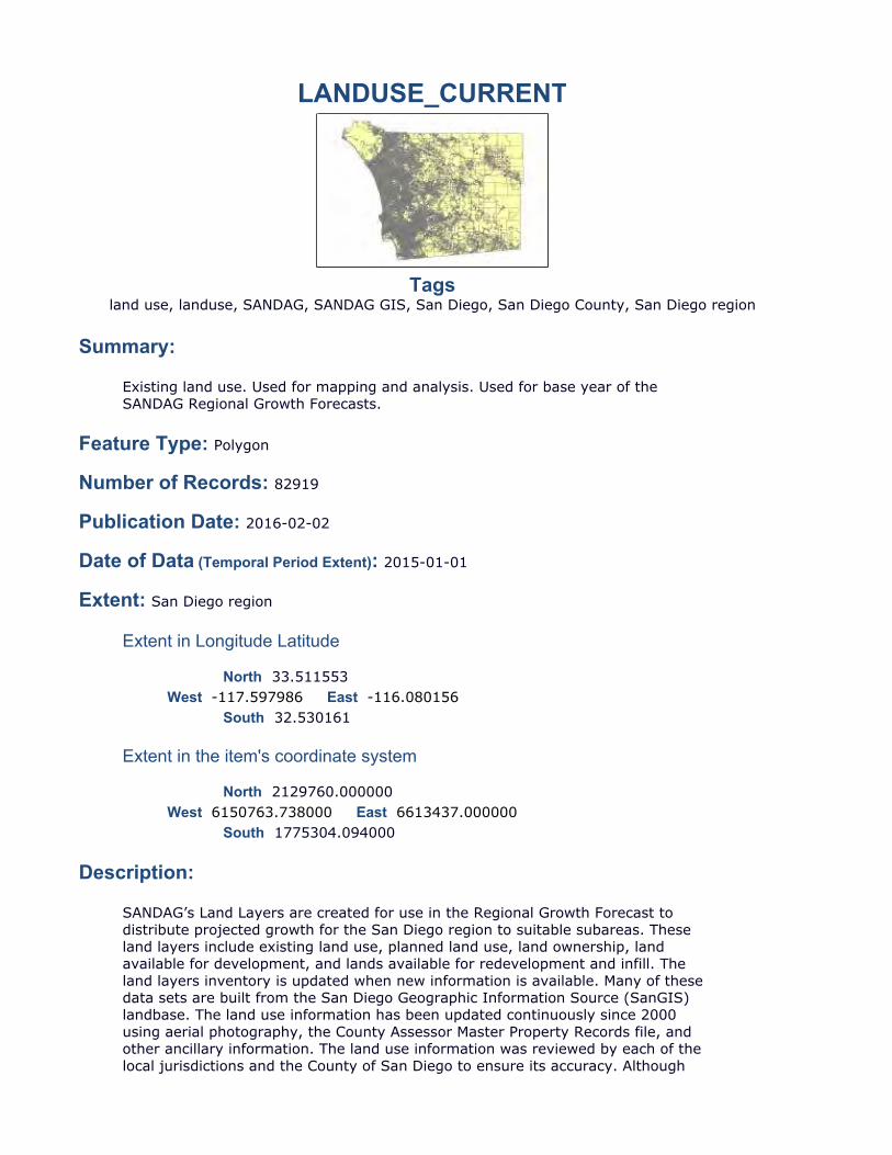
LANDUSE_CURRENT
Tagsland use, landuse, SANDAG, SANDAG GIS, San Diego, San Diego County, San Diego region
Summary:
Feature Type: Polygon
Number of Records: 82919
Publication Date: 2016-02-02
Date of Data (Temporal Period Extent): 2015-01-01
Extent: San Diego region
Extent in Longitude Latitude
North 33.511553
South 32.530161
Extent in the item's coordinate system
North 2129760.000000
South 1775304.094000
Description:
Existing land use. Used for mapping and analysis. Used for base year of the SANDAG Regional Growth Forecasts.
West -117.597986 East -116.080156
West 6150763.738000 East 6613437.000000
SANDAG’s Land Layers are created for use in the Regional Growth Forecast to distribute projected growth for the San Diego region to suitable subareas. These land layers include existing land use, planned land use, land ownership, land available for development, and lands available for redevelopment and infill. The land layers inventory is updated when new information is available. Many of these data sets are built from the San Diego Geographic Information Source (SanGIS) landbase. The land use information has been updated continuously since 2000 using aerial photography, the County Assessor Master Property Records file, and other ancillary information. The land use information was reviewed by each of the local jurisdictions and the County of San Diego to ensure its accuracy. Although
Credits:
Use Limitation:
Resource Details:
Status: CompletedType: VectorUpdate Frequency: AnnuallyNext Update: Not specified
Spatial Reference System:
Type: ProjectedReference: GCS_North_American_1983Projection: NAD_1983_StatePlane_California_VI_FIPS_0406_Feet
Identifier: 2230Codespace: EPSGVersion: 8.6.2
Contacts:
Point of Contact
John Hofmockel, GIS AnalystSANDAG401 B StreetSan Diego, CA. 92101
[email protected](619) 699-6986
Distributor
this inventory contains more categorical detail and has better positional accuracy than previous land use inventories, users should be aware that this data may be too generalized for some local planning projects. Since each General Plan/Community Plan Land Use Elements have their own individualized way of categorizing their future land use designations, an aggregate planned land use code was devised (PLU). Each General Plan/Community Plan land use designation was cross-walked to a SANDAG PLU code. Adjacent parcel polygons with the same land use have been aggregated (dissolved) into a single feature.The Landuse featureclass was dissolved from SANDAG's Land Layer featureclass ludu2015.
SANDAG Technical Services - GIS, SANDAG Land Layers Inventory
Mapping Source: SanGIS landbase (i.e. parcels), SANDAG, County Assessor's Master Property Records file, Cleveland National Forest, Bureau of Land Management (BLM), State Parks, other public agency contacts, and local agency review.
Please read the SANDAG Data Disclaimer first before using SANDAG data.
SANDAG401 B StreetSan Diego, CA. 92101John HofmockelGIS [email protected](619) 699-6986
Distribution Ordering Instructions:
Online Ordering Description:
Fields:
Overview:
Citation:
__FID (OID)
Shape (Geometry)
lu (SmallInteger)
Shape_Area (Double)
landuse (String)
SHAPE_LEN (Double)
Metadata Last Update: 2016-05-10Regional GIS Data Warehouse (RGDW) Publication Stylesheet 1.4
Downloadable from the SANDAG/SanGIS Regional GIS Data Warehouse.
http://www.sandag.org/index.asp?subclassid=100&fuseaction=home.subclasshome
lu is the 4-digit SANDAG land use code. landuse is the brief description of the land use
SANDAG Land Layers Inventory
Internal feature number.
Feature geometry.
Existing land use. SANDAG four-digit land use code.
http://www.sandag.org/resources/maps_and_gis/gis_downloads/downloads/codes/land_use_codes.html
Area of feature in internal units squared.
Land use description
http://www.sandag.org/resources/maps_and_gis/gis_downloads/downloads/codes/Land_Use_Definitions.html

UUP MASTER PLAN UPDATE – FACTORS AND METHOD
SECTION 7 MAJOR_ROADS
RD_MAJOR_SG
TagsMojor Roads
Summary:
Feature Type: Line
Number of Records: 12302
Publication Date:
Defining existing major roads
Date not provided by data owner.
Date of Data (Temporal Period Extent): Date not provided by data owner.
Extent:
Extent in Longitude Latitude
North 34.092030
South 31.145204
Extent in the item's coordinate system
North 2340997.500074
South 1273586.875057
Description:
Credits:
West -118.118599 East -114.480558
West 5995823.500028 East 7097477.500128
SANDAG GIS
SANDAG Regional Transportation Improvement Program and Regional Transportation Plan, San Diego Geographic Information Source (SanGIS) centerline road file. General Plan circulation elements of the local jurisdictions; Caltrans State Highway inventory.
Page 1 of 3
4/29/2015file:///C:/Users/lwedley/AppData/Local/Temp/arc6356/tmp5F91.tmp.htm
Use Limitation:There are no access and use limitations for this item.
Resource Details:
Status: Not specifiedType: VectorUpdate Frequency: Not specifiedNext Update: Not specified
Spatial Reference System:
Type: ProjectedReference: GCS_North_American_1983Projection: NAD_1983_StatePlane_California_VI_FIPS_0406_Feet
Identifier: 2230Codespace: EPSGVersion: 7.11.2
Contacts:
Point of Contact Not specified
Distributor
San Diego Association of Governments (SANDAG)John HofmockelSenior Research [email protected]
Fields:
Overview:
Citation:
FID Internal feature numberShape Feature Geometry
NM Road nameFXNM From cross-street nameTXNM To cross-street nameIYR Initial year that the road opened to traffic (1990 base year)IFC Functional classSD Road location
IFC Initial functional classification, where:1 = Freeway2 = Prime Arterial3 = Major Arterial4 = Collector5 = Local Collector6 = Rural Collector
Page 2 of 3
4/29/2015file:///C:/Users/lwedley/AppData/Local/Temp/arc6356/tmp5F91.tmp.htm
__SD (SmallInteger)
IYR (OID)
SHAPE (SmallInteger)
IFC (Geometry)
Shape (String)
NM (String)
FXNM (String)
TXNM (SmallInteger)
Metadata Last Update: 2015-04-29Regional GIS Data Warehouse (RGDW) Publication Stylesheet 1.4
7 = Rural Light Collector8 = Local Street9 = Ramp
SD Road location0 = Outside of San Diego County1 = Inside of San Diego County
Road location
Initial year that the road opened to traffic (1990 base year)
Feature geometry.
Functional class (Refer to IFC in Overview Citation)
Feature geometry.
Road name
From cross-street name
To cross-street name
Page 3 of 3
4/29/2015file:///C:/Users/lwedley/AppData/Local/Temp/arc6356/tmp5F91.tmp.htm

UUP MASTER PLAN UPDATE – FACTORS AND METHOD
SECTION 8 MUNICIPAL_BOUNDARIES
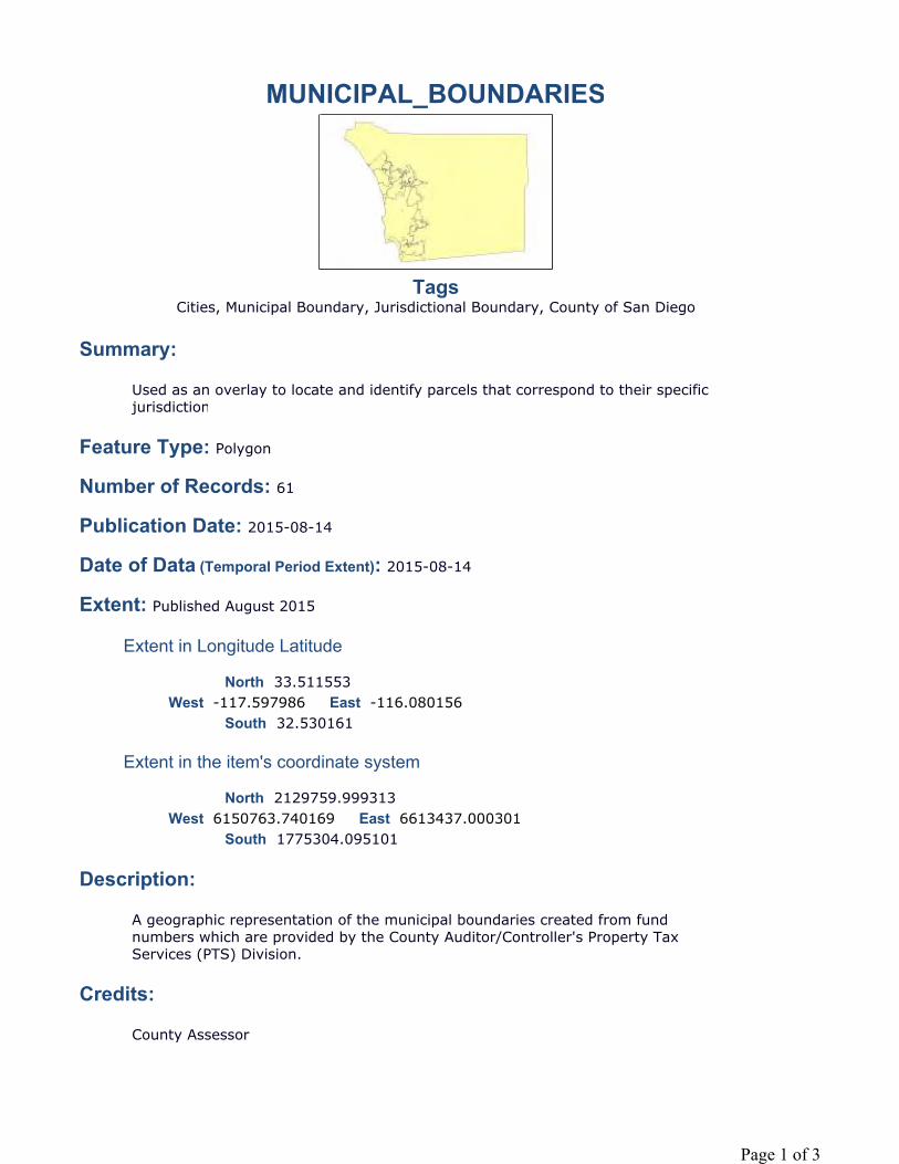
MUNICIPAL_BOUNDARIES
TagsCities, Municipal Boundary, Jurisdictional Boundary, County of San Diego
Summary:
Feature Type: Polygon
Number of Records: 61
Publication Date: 2015-08-14
Date of Data (Temporal Period Extent): 2015-08-14
Extent: Published August 2015
Extent in Longitude Latitude
North 33.511553
South 32.530161
Extent in the item's coordinate system
North 2129759.999313
South 1775304.095101
Description:
Credits:
Used as an overlay to locate and identify parcels that correspond to their specific jurisdiction
West -117.597986 East -116.080156
West 6150763.740169 East 6613437.000301
A geographic representation of the municipal boundaries created from fund numbers which are provided by the County Auditor/Controller's Property Tax Services (PTS) Division.
County Assessor
Page 1 of 3
Use Limitation:
Topics and Keywords
Topic Categories: Boundaries Location
Themes:
Cities, Municipal Boundary, Jurisdictional Boundary, County of San Diego
Places:
Cities, Municipal Boundary, Jurisdictional Boundary, County of San Diego
Resource Details:
Status: CompletedType: VectorUpdate Frequency: AnnuallyNext Update: 20160801
Spatial Reference System:
Type: ProjectedReference: GCS_North_American_1983Projection: NAD_1983_StatePlane_California_VI_FIPS_0406_Feet
Identifier: 2230Codespace: EPSGVersion: 7.9.4
Contacts:
Point of Contact
Tony Pocina, Senior GIS AnalystCounty of San Diego; Assessors Office; Mapping1600 Pacific Highway Room 103San Diego, CA. 92101
Distributor
County of San Diego; Assessors Office; Mapping1600 Pacific Highway Room 103San Diego, CA. 92101
Resolutions, legal descriptions, and recorded maps and documents are the final authority of any boundary disputes.
Page 2 of 3
Tony PocinaSenior GIS [email protected]
Distribution Ordering Instructions:
Fields:
Overview:
Citation:
__FID (OID)
Shape (Geometry)
NAME (String)
CODE (String)
Shape_Area (Double)
SHAPE_LEN (Double)
Metadata Last Update: 2015-08-20Regional GIS Data Warehouse (RGDW) Publication Stylesheet 1.4
Refer to SanGIS website (http://www.sangis.org/services/index.html) to obtain further information on mapping and data extraction services available from SanGIS
This polygon shows the areal extents of the Municipal Jurisdiction boundaries within San Diego County.
Assessors Office
Internal feature number.
Feature geometry.
Municipal Jurisdictions
CODE
Area of feature in internal units squared.
Page 3 of 3

UUP MASTER PLAN UPDATE – FACTORS AND METHOD
SECTION 9 PARCELS
PARCELS
TagsParcel, San Diego County, Parcels, Property, Tax Parcel, Boundary
Summary:
Feature Type: Polygon
Number of Records: 1056679
Publication Date: 2015-10-05
Date of Data (Temporal Period Extent): 2015-10-05
Extent: The spatial extent of this dataset is San Diego County. The temporal extent is variable.
Extent in Longitude Latitude
North 33.511553
South 32.530161
Extent in the item's coordinate system
North 2129760.000000
South 1775304.094000
Description:
Polygons representing current taxable parcels in San Diego County and some non-taxable parcels. Taxable parcels that cannot be represented by a polygon (i.e. possessory interest parcels) may not be shown. This layer contains only those attributes from the Assessor's Master Property Record (MPR) or Parcel Assessment Record (PAR) that have been authorized for release to the public by the Assessor/Recorder/County Clerk's (ARCC) Office.
West -117.597986 East -116.080156
West 6150763.738000 East 6613437.000000
Parcels represent taxable pieces of property. A parcel is created by the San Diego County Assessor/Recorder/County Clerk (ARCC) to identify a specific portion of real property that is taxed at a certain rate for a certain owner. Tax parcels are typically the same as a legally subdivided lot but are not necessessarily so. For example, a single owner may own a legally subdivided piece of property but there may be two or more tax parcels covering that property. Legal subdivisions are
Page 1 of 19

shown in the LOTS layer.Parcels are keyed to the Assessor Parcel Number (APN) and the parcel polygon identifier (PARCELID).The SanGIS parcel layers are “stacked” parcels. That means that for any piece of ground there may be multiple parcels. For example, a condominium building in downtown San Diego may have 200 individual condos. Each condo is a separate taxable parcel. All 200 parcels will be associated with the same physical lot on the ground. When the SanGIS parcel layer is created each individual condo has a polygon representing the physical location of the parent parcel. In this example there will be 200 polygons all stacked on top of each other that represent the taxable parcels and each polygon will have the same physical characteristics (shape, size, area, location) – they are, essentially, copies of each other. However, other associated information (owner, document numbers, etc) will be different for each. In this case, each condo unit will have its own parcel number and there will be no single parcel representing the lot on the ground. Besides condominiums there are two other cases where you will see stacked parcels – possessory interest and mobile homes. Possessory interests have Assessor Parcel Numbers (APNs) that start with 76x. A possessory interest (or PI) parcel represents a taxable interest in the underlying, or parent, parcel but not necessarily ownership. For instance, a private company may have an arrangement with a University to operate a business on campus – a coffee shop or gift shop for example. The private business is taxable and is assinged a 76x APN and that APN is associated with the parent parcel which is owned by the University. Possessory intestests do not represent ownership on the parcel, only a taxable interest in the underlying parent parcel.Mobile home parcel APNs start with 77x. In a manner similar to the possessory interests, mobile home owners own their home (coach) but not the underlying property on which the house sits. The actual mobile home is a separate taxable parcel associated with the mobile home park parent parcel. These taxable parcels all have the same polygon as the underlying parent parcel and will show as stacked parcels as well.This dataset contains parcels as shown on the Assessor Parcel Maps (APM). However, parcels shown in this layer may lag that of the official APM by a number of weeks due to how SanGIS is notified of the newly created parcel and the timing of publication of the parcel layer.This dataset contains the parcel polygon and associated parcel information provided by the County ARCC in thier Master Property Record (MPR file) and Parcel Assessment Record (PAR file). In addition to the MPR and PAR data assigned by ARCC, SanGIS may add situs address information if it has been provided by the addressing authority in which the parcel is situated. The situs address information provided by SanGIS may not be the same as the SITUS address data in the MPR.This dataset contains site address information along with owner names and addresses, and other property information. Key fields in this dataset include:Land use information provided in the NUCLEUS_USE_CD field (225 types with a 3-digit domain). The ASR_LANDUSE field is an older version of this field but comprises more generalized land uses (91 types). Generalized land use zoning information is provided in the NUCLEUS_ZONE_CD field. The ASR_ZONE field is an older version of this field. Land use zoning is generalized comprising 9 zone types. This can provide a useful approximation for parcels that are outside of the San Diego City and County zoning jurisdictions.Please note that land use and zoning fields are not regularly maintained by the Assessor's Office and should only be used as an approximate guide. Updates are only made when there is new construction, or a change in ownership. They are not updated when the County and Local Cities update their zoning data or when permit changes to properties are completed. Please refer to city and County official zoning datasets for official zoning information, and to SANDAG for more current land use data. NOTE: If the name of this layer includes "_NORTH", "_SOUTH", or "_EAST" it represents a subset of the entire San Diego County Parcel Base. That is, the "_NORTH" layer includes only parcels generally in the Northwestern portion of the County. The "_SOUTH" layer includes parcels in the Southwestern portion. And the "_EAST" layer includes parcels in the approximate Eastern half of the County.
Page 2 of 19
Credits:
Use Limitation:
Topics and Keywords
Topic Categories: Boundaries Location Planning Cadastral
Themes:
Parcel, Land, taxable parcel, property, boundaries, lots
Places:
California, County of San Diego, Carlsbad, Coronado, Chula Vista, Del Mar, El Cajon, Encinitas, Escondido, Imperial Beach, Lemon Grove, La Mesa, National City, Oceanside, Poway, San Diego, San Marcos, Solana Beach, Santee, Vista
Resource Details:
Status: On GoingType: VectorUpdate Frequency: WeeklyNext Update: 2014-08-31
Spatial Reference System:
Type: ProjectedReference: GCS_North_American_1983Projection: NAD_1983_StatePlane_California_VI_FIPS_0406_Feet
Identifier: 2230Codespace: EPSGVersion: 7.9.4
SanGIS using legal recorded data provided by the County Recorders and Assessor's Office. See the County ARCC website at https://arcc.sdcounty.ca.gov/Pages/default.aspx for more information about tax parcels
Data is generalized and created for use in regional projects. Please refer to SanGIS GIS data end user use agreement and disclaimer which is available at the following: http://www.sangis.org/Legal_Notice.htm.Attribute information in this layer contains only the information on property characteristics that has been authorized for public release by the Assessor/Recorder/County Clerk's Office.Parcels shown in this layer may lag the official Assessor Parcel Map due to timing of data transmissions and publication schedules.Please note that land use, zoning and property description fields are not regularly maintained and should only be used as an approximate guide. Please refer to city and County official zoning datasets for official zoning information, and to SANDAG for more current land use data.
Page 3 of 19
Contacts:
Point of Contact
Operations Manager, Operations ManagerSanGIS5510 Overland Avenue, Suite 230San Diego, California. 92123
[email protected](858) 874-7000
Distributor
SanGIS5510 Overland Avenue, Suite 230San Diego, California. 92123Data LibrarianData [email protected](858) 874-7000
Distribution Ordering Instructions:
Online Ordering Description:
Fields:
Overview:
Refer to SanGIS website (http://www.sangis.org/services/index.html) to obtainfurther information on mapping and data extraction services available from SanGIS.
Parcels, without certain restricted fields and owner names, are available for downloadable as shapefile from http://www.sangis.org/download/index.html and parcels can be viewd on the SanGIS interactive webmap (http://sdgis.sandag.org/)
This dataset contains over 60 attributes with the key, unique, field being APN (full Assessor Parcel Number). The majority of the attributes come from the Assessor's Master Property Record (MPR) or Parcel Assessment Record (PAR). Attributes maintained by SanGIS are:ADDRFRAC; ADDRNO; ADDRUNIT; ROADNAME; ROADPDIR; ROADPOSTD; ROADSFX; ZIP; APNID; PARCELID; OVERLAY_JURIS; X_COORD; Y_COORD; SUB_TYPE
All other attributes are from the Assessor's MPR or PAR data. Attributes that are from the Assessor's Office will include the wording "Field updated weekly from Assessor's Master Property Record (MPR) file." or something similar in the attribute description.
Attributes fall into three general categories:
Parcel Characteristics - fields related to the tax parcel itself, how it is identified, how it was created, and what jurisidctions and tax rate areas it falls within. Data
Page 4 of 19
Citation:
__FID (OID)
APN (String)
APN_8 (String)
PARCELID (Double)
may come from the Assessor's Master Property Record (MPR) or be applied by SanGIS as part of the polygon creation and maintenance process.
Property Characteristics - fields related to land use, improvements, and assessed valuations. All fields in this category are from the Assessor's MPR or PAR data.
Addresses - there are three sets of address fields - Owner mailing address, MPR SITUS address, SanGIS address:
Owner address fields provide mailing address information for the property owner. Owner address field names all begin with OWN_. Owner addresses may be in state or out of state and do not reflect site loction.
SITUS addresses are the site locationcome from the Assessor's MPR. SITUS addresses are intended to show the actual, physical, location of the parcel and may not be the same as the resident mailing address. All SITUS address fields begin with either SITUS_ or NUCLEUS_SITUS_
SanGIS addresses are those provided to SanGIS by the local jurisdiction addressing authority. Not all parcels will have a SanGIS address. SanGIS address fields are:ADDRFRAC; ADDRNO; ADDRUNIT; ROADNAME; ROADPDIR; ROADPOSTD; ROADSFX; ZIP
SanGIS using legal recorded data provided by the County Recorders and Assessor's Office. See the County ARCC website at https://arcc.sdcounty.ca.gov/Pages/default.aspx for more information about tax parcels
Internal feature number.
Assessor Parcel Number (APN) - Full 10 digitAPN is of the form: BBB-PPx-yy-zz where:BBB = Assessor Map Book numberPP = Assessor Map Book Page numberx = Assessor Map Book Block numberyy = Parcel numberzz = Subunit number (for condos)
Assessor Parcel Number (APN) - First 8 digitsSame as full 10 digit APN but without the subunit idsAssessor Parcel Number (APN) - Full 10 digitAPN is of the form: BBB-PPx-yy where:BBB = Assessor Map Book numberPP = Assessor Map Book Page numberx = Assessor Map Book Block numberyy = Parcel number
SanGIS internal Parcel polygon ID number. Not a unique field. Mulitple APNs may have the same
Page 5 of 19
OWN_NAME1 (String)
OWN_NAME2 (String)
OWN_NAME3 (String)
FRACTINT (Double)
OWN_ADDR1 (String)
OWN_ADDR2 (String)
OWN_ADDR3 (String)
OWN_ADDR4 (String)
OWN_ZIP (String)
LEGLDESC (String)
ASR_LAND (Double)
First property owners nameField updated weekly from Assessor's Master Property Record (MPR) file.
Second owner nameField updated weekly from Assessor's Master Property Record (MPR) file.
Third owner nameField updated weekly from Assessor's Master Property Record (MPR) file.
Fractional Interest Code Code, Description1, single interest, 2, multiple interests, equal shares, 3, multiple interests, unequal shares, 4, multiple interests, shares unknown, 5, all as joint tenants
Field updated weekly from Assessor's Master Property Record (MPR) file.
Property owner mailing address, line 1Field updated weekly from Assessor's Master Property Record (MPR) file.
Property owner mailing address, line 2Field updated weekly from Assessor's Master Property Record (MPR) file.
Property owner mailing address, line 3Field updated weekly from Assessor's Master Property Record (MPR) file.
Property owner mailing address, line 4Field updated weekly from Assessor's Master Property Record (MPR) file.
Property owner mailing address ZIP codeField updated weekly from Assessor's Master Property Record (MPR) file.
Abbreviated legal description of parcelField updated weekly from Assessor's Master Property Record (MPR) file.
Assessed land value
Page 6 of 19
ASR_IMPR (Double)
ASR_TOTAL (Double)
DOCTYPE (String)
DOCNMBR (String)
DOCDATE (String)
ACREAGE (Double)
TAXSTAT (String)
OWNEROCC (String)
TRANUM (String)
Field updated weekly from Assessor's Master Property Record (MPR) file.
Assessed improvement valueField updated weekly from Assessor's Master Property Record (MPR) file.
Total assessed valueField updated weekly from Assessor's Master Property Record (MPR) file.
Type of document that created this parcel.Field updated weekly from Assessor's Master Property Record (MPR) file.Code: Description0; Unresearched1; Grant deed2; Quit claim3; Unrecorded deed4; Recorded death certificate5; Unrecorded death certificate6; Other types recorded document (Trustees deed)7; Unknown8; Recorded contract
Document number that created this parcel Field updated weekly from Assessor's Master Property Record (MPR) file.
Document recording date of document that created this parcel.Field updated weekly from Assessor's Master Property Record (MPR) file.
Parcel acreage if over 0.25 acres (blank if smaller)Field updated weekly from Assessor's Master Property Record (MPR) file.
Tax status code Field updated weekly from Assessor's Master Property Record (MPR) file.Code, DescriptionN, NontaxableT, Taxable
Owner occupied indicator (Y=yes or blank)Field updated weekly from Assessor's Master Property Record (MPR) file.
Tax rate area numberField updated weekly from Assessor's Master Property Record (MPR) file.
Page 7 of 19
ASR_ZONE (Integer)
SUBMAP (String)
SITUS_ZIP (String)
SUBNAME (String)
UNITQTY (Integer)
X_COORD (Double)
Y_COORD (Double)
MULTI (String)
ADDRNO (Double)
Assessor Info ZoneLegacy field, irregularly updated by Assessor's Office. NUCLEUS_ZONE_CD represents a more detailed version of this field.Code; Description0; UNZONED1; SINGLE FAMILY RESIDENTIAL2; MINOR MULTIPLE3; RESTRICTED MULTIPLE4; MULTIPLE RESIDENTIAL5; RESTRICTED COMMERCIAL6; COMMERCIAL7; INDUSTRIAL8; AGRICULTURAL9; SPECIAL AND/OR MISC.
Subdivision map number or parcel map numberField updated weekly from Assessor's Master Property Record (MPR) file.
Site address Zip Code.Field updated weekly from Assessor's Master Property Record (MPR) file.
Subdivision name as shown on recorded subdivision map or parcel map numberOriginated with City of San Diego. Subdivisions used for Planning and Development. Updated biannually.
Number of dwelling unitsField updated weekly from Assessor's Master Property Record (MPR) file.
X coordinate of approximate parcel centroid. California State Plane, Zone 6, NAD83
Y coordinate of approximate parcel centroid. California State Plane, Zone 6, NAD83
Multiple parcel indicator (Y = condos or timeshares)Field updated weekly from Assessor's Master Property Record (MPR) file.
Site address number if provided by addressing authority of local jurisdiction. Maintained by SanGIS and updated as new address information is provided.
Page 8 of 19
ADDRFRAC (String)
ADDRUNIT (String)
SUB_TYPE (Integer)
ZIP (String)
ROADPDIR (String)
ROADNAME (String)
ROADPOSTD (String)
Address fractional part, if any, if provided by addressing authority of local jurisdiction. Maintained by SanGIS and updated as new address information is provided.
Building or unit number, if any, if provided by addressing authority of local jurisdiction. Maintained by SanGIS and updated as new address information is provided.
Type of parcel as maintained by SanGIS. Right-of-way parcels (sub-type 5) are not published in SanGIS parcel layers. See RIGHT_OF_WAY layer for dedicated rights-of-way.Code; Sub-Type1; Regular parcel with APN number2; Unparcelled Private Road3; Unparcelled Government Land4; Unparcelled Common Area5; Right-of-Way
Site address ZIP code determined from a special overlay of the SanGIS ZIPCODE layer.
Site address road direction preceeding the road name, if provided by addressing authority of local jurisdiction. Maintained by SanGIS and updated as new address information is provided.Up to two characters:N: NorthNE: NortheastNW: NorthwestS: SouthSE: SoutheastSW: SouthwestE: EastW: West
Site address road name, if provided by addressing authority of local jurisdiction. Maintained by SanGIS and updated as new address information is provided.
SanGIS Road post direction. That is, the direction following the road name and/or suffix. If provided by addressing authority of local jurisdiction. Maintained by SanGIS and updated as new address information is provided.
Up to two characters:N: NorthNE: NortheastNW: NorthwestS: South
Page 9 of 19
ROADSFX (String)
SE: SoutheastSW: SouthwestE: EastW: West
Site address road name suffix, if provided by addressing authority of local jurisdiction. Maintained by SanGIS and updated as new address information is provided.
Street name suffix is abbreviated. Four letter abbreviations are used according to the SanGIS standards manual as follows:
ALY: ALLEYARC: ARCADEAVE: AVENUEBP: BIKEPATHBLVD: BOULEVARDBRG: BRIDGEBYP: BYPASSCSWY: CAUSEWAYCIR: CIRCLECTE: CORTECT: COURTCV: COVE CRES: CRESCENTXING: CROSSINGDR: DRIVEDRWY: DRIVEWAYEXPY: EXPRESSWAYEXT: EXTENTIONFRY: FERRYFWY: FREEWAYGLEN: GLENHWY: HIGHWAYINTR: INTERCHANGELN: LANELOOP: LOOPMALL: MALLPKY: PARKWAYPASS: PASSPATH: PATHPL: PLACEPLZ: PLAZAPT: POINTPTE: POINTERAMP: RAMPRD: ROADROW: ROWSQ: SQUAREST: STREETTER: TERRACETRL: TRAILTKTL: TRUCKTRAILWALK: WALKWAY: WAY
Page 10 of 19
Shape (Geometry)
SHAPE_AREA (Double)
SITUS_JURI (String)
SITUS_STRE (String)
SITUS_SUFF (String)
SITUS_POST (String)
SITUS_PRE_ (String)
SITUS_ADDR (Double)
Feature geometry.
Area of feature in internal units squared.
Situs Jurisdiction. Jurisidction in which the property is located. Field updated weekly by query script from Tax Rate Area (TRA) number in Assessor's Master Property Record (MPR) file.
Code; JurisdictionCB; CarlsbadCN; UnincorporatedCO; CoronadoCV; Chula VistaDM; Del MarEC; El CajonEN; EncinitasES; EscondidoIB; Imperial BeachLG; Lemon GroveLM; La MesaNC; National CityOC; OceansidePW; PowaySD; San DiegoSM; San MarcosSO; Solana BeachST; SanteeVS; Vista
Site Address Street Name.Field updated weekly from Assessor's Master Property Record (MPR) file.
Site Address Suffix or Street type (e.g. AV, BAY, CT, ST, DR)Field updated weekly from Assessor's Master Property Record (MPR) file.
Post direction of road, The direction following the street name and/or street suffixField updated weekly from Assessor's Master Property Record (MPR) file.
Road Prefix Direction, The direction preceeding the street name.Field updated weekly from Assessor's Master Property Record (MPR) file.
Site address number.Field updated weekly from Assessor's Master Property Record (MPR) file.
Page 11 of 19
SITUS_FRAC (String)
SITUS_BUIL (String)
SITUS_SUIT (String)
SITUS_COMM (String)
ASR_LANDUS (Integer)
Site address fraction (if any), e.g. 2/3 or W or A. Can be number or letter.Field updated weekly from Assessor's Master Property Record (MPR) file.
Blank field. Part of standard set of address fields.Field updated weekly from Assessor's Master Property Record (MPR) file.
Suite, unit, or location of business within building.Field updated weekly from Assessor's Master Property Record (MPR) file.
Site address community or post office name.Field updated weekly from Assessor's Master Property Record (MPR) file.
Assessment land use codeLegacy field, irregularly maintained by the Assessors Office. NUCLEUS_USE_CD represents a more detailed version of this field.
Code; Land Use Description06; INFORMATION PARCEL- GENERIC07; TIME SHARE GENERIC09; MANUFACTURED HOME IN PARK - NOT SPECIFIED10; VACANT RESIDENTIAL-GENERIC11; SINGLE FAMILY RESIDENTIAL-GENERIC12; DUPLEX-GENERIC13; MULTIPLE 2 TO 4 UNITS-GENERIC14; MULTIPLE 5 TO 15 UNITS-GENERIC15; MULTIPLE 16 TO 60 UNITS-GENERIC16; MULTIPLE 61 UNITS AND UP-GENERIC17; CONDOMINIUMS AND OTHER RESIDENTAL CLASSIFICATIONS18; CO-OP GENERIC19; SPECIAL- SLIVER, SMALL PARCEL20; VACANT LAND COMMERCIAL21; GENERIC COMMERCIAL OFFICE/RETAIL 1-3 STORIES22; GENERIC-4 AND MORE STORY OFFICE BUILDING23; REGIONAL SHOPPING CENTER24; COMMUNITY SHOPPING CENTER25; NEIGHBORHOOD SHOPPING CENTER26; HOTEL/MOTEL27; SERVICE STATION-GENERIC28; GENERIC-MEDICAL/DENTAL OFFICE29; REST HOME/CONVALESCENT HOPITAL30; OFFICE CONDOMINIUMS31; GARAGE PARKING LOT/USED CAR 32; TRAILER PARK33; THEATER-GENERIC34; BOWLING ALLEY35; GENERIC-RESTAURANT/NIGHT CLUB/TAVERN36; CAR WASH37; GROCERY/DRUG LARGE CHAIN GENERIC38; AUTO SALES/SERVICE AGENCY
Page 12 of 19
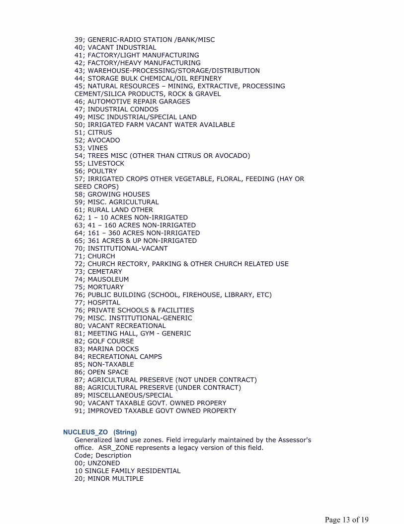
NUCLEUS_ZO (String)
39; GENERIC-RADIO STATION /BANK/MISC40; VACANT INDUSTRIAL41; FACTORY/LIGHT MANUFACTURING42; FACTORY/HEAVY MANUFACTURING43; WAREHOUSE-PROCESSING/STORAGE/DISTRIBUTION44; STORAGE BULK CHEMICAL/OIL REFINERY45; NATURAL RESOURCES – MINING, EXTRACTIVE, PROCESSING CEMENT/SILICA PRODUCTS, ROCK & GRAVEL46; AUTOMOTIVE REPAIR GARAGES47; INDUSTRIAL CONDOS49; MISC INDUSTRIAL/SPECIAL LAND50; IRRIGATED FARM VACANT WATER AVAILABLE51; CITRUS52; AVOCADO53; VINES54; TREES MISC (OTHER THAN CITRUS OR AVOCADO)55; LIVESTOCK56; POULTRY57; IRRIGATED CROPS OTHER VEGETABLE, FLORAL, FEEDING (HAY OR SEED CROPS)58; GROWING HOUSES59; MISC. AGRICULTURAL61; RURAL LAND OTHER62; 1 – 10 ACRES NON-IRRIGATED63; 41 – 160 ACRES NON-IRRIGATED64; 161 – 360 ACRES NON-IRRIGATED65; 361 ACRES & UP NON-IRRIGATED70; INSTITUTIONAL-VACANT71; CHURCH72; CHURCH RECTORY, PARKING & OTHER CHURCH RELATED USE73; CEMETARY74; MAUSOLEUM75; MORTUARY76; PUBLIC BUILDING (SCHOOL, FIREHOUSE, LIBRARY, ETC)77; HOSPITAL76; PRIVATE SCHOOLS & FACILITIES79; MISC. INSTITUTIONAL-GENERIC80; VACANT RECREATIONAL81; MEETING HALL, GYM - GENERIC82; GOLF COURSE83; MARINA DOCKS84; RECREATIONAL CAMPS85; NON-TAXABLE 86; OPEN SPACE 87; AGRICULTURAL PRESERVE (NOT UNDER CONTRACT)88; AGRICULTURAL PRESERVE (UNDER CONTRACT)89; MISCELLANEOUS/SPECIAL90; VACANT TAXABLE GOVT. OWNED PROPERY91; IMPROVED TAXABLE GOVT OWNED PROPERTY
Generalized land use zones. Field irregularly maintained by the Assessor's office. ASR_ZONE represents a legacy version of this field.Code; Description00; UNZONED10 SINGLE FAMILY RESIDENTIAL20; MINOR MULTIPLE
Page 13 of 19
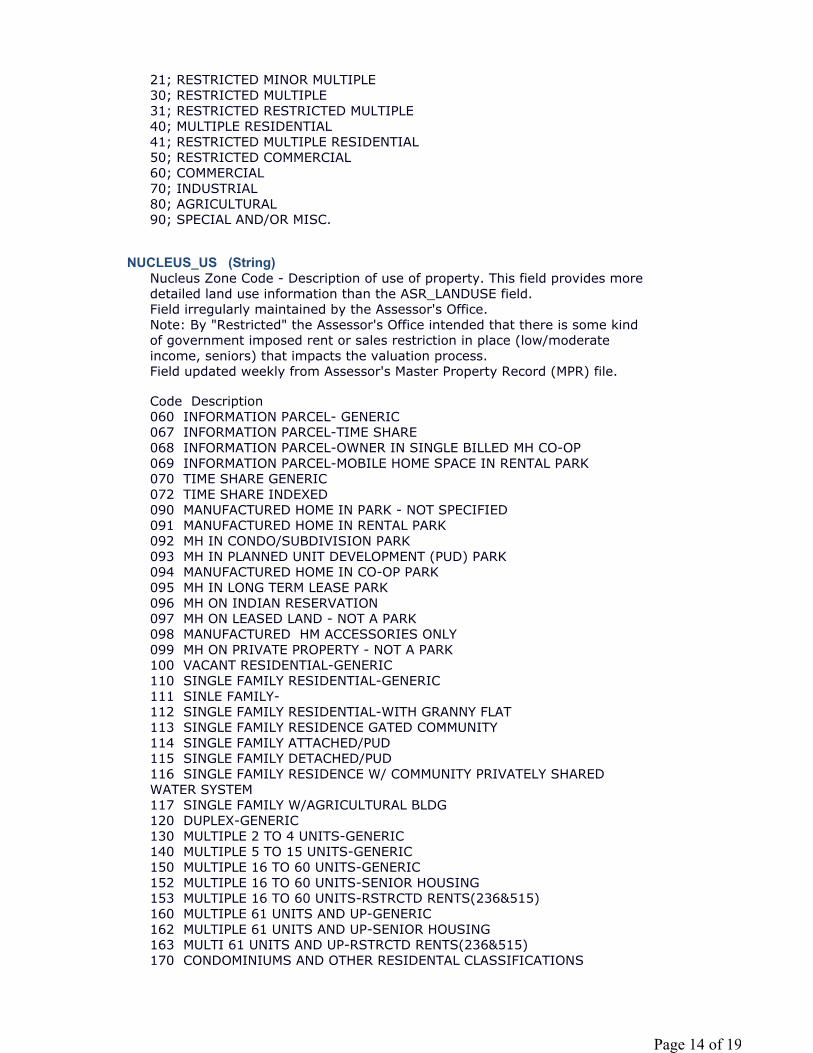
NUCLEUS_US (String)
21; RESTRICTED MINOR MULTIPLE30; RESTRICTED MULTIPLE31; RESTRICTED RESTRICTED MULTIPLE40; MULTIPLE RESIDENTIAL41; RESTRICTED MULTIPLE RESIDENTIAL50; RESTRICTED COMMERCIAL60; COMMERCIAL70; INDUSTRIAL80; AGRICULTURAL90; SPECIAL AND/OR MISC.
Nucleus Zone Code - Description of use of property. This field provides more detailed land use information than the ASR_LANDUSE field.Field irregularly maintained by the Assessor's Office.Note: By "Restricted" the Assessor's Office intended that there is some kind of government imposed rent or sales restriction in place (low/moderate income, seniors) that impacts the valuation process.Field updated weekly from Assessor's Master Property Record (MPR) file.
Code Description060 INFORMATION PARCEL- GENERIC067 INFORMATION PARCEL-TIME SHARE068 INFORMATION PARCEL-OWNER IN SINGLE BILLED MH CO-OP069 INFORMATION PARCEL-MOBILE HOME SPACE IN RENTAL PARK070 TIME SHARE GENERIC072 TIME SHARE INDEXED090 MANUFACTURED HOME IN PARK - NOT SPECIFIED091 MANUFACTURED HOME IN RENTAL PARK092 MH IN CONDO/SUBDIVISION PARK093 MH IN PLANNED UNIT DEVELOPMENT (PUD) PARK094 MANUFACTURED HOME IN CO-OP PARK095 MH IN LONG TERM LEASE PARK096 MH ON INDIAN RESERVATION097 MH ON LEASED LAND - NOT A PARK098 MANUFACTURED HM ACCESSORIES ONLY099 MH ON PRIVATE PROPERTY - NOT A PARK100 VACANT RESIDENTIAL-GENERIC110 SINGLE FAMILY RESIDENTIAL-GENERIC111 SINLE FAMILY-112 SINGLE FAMILY RESIDENTIAL-WITH GRANNY FLAT113 SINGLE FAMILY RESIDENCE GATED COMMUNITY114 SINGLE FAMILY ATTACHED/PUD115 SINGLE FAMILY DETACHED/PUD116 SINGLE FAMILY RESIDENCE W/ COMMUNITY PRIVATELY SHARED WATER SYSTEM117 SINGLE FAMILY W/AGRICULTURAL BLDG120 DUPLEX-GENERIC130 MULTIPLE 2 TO 4 UNITS-GENERIC140 MULTIPLE 5 TO 15 UNITS-GENERIC150 MULTIPLE 16 TO 60 UNITS-GENERIC152 MULTIPLE 16 TO 60 UNITS-SENIOR HOUSING153 MULTIPLE 16 TO 60 UNITS-RSTRCTD RENTS(236&515)160 MULTIPLE 61 UNITS AND UP-GENERIC162 MULTIPLE 61 UNITS AND UP-SENIOR HOUSING163 MULTI 61 UNITS AND UP-RSTRCTD RENTS(236&515)170 CONDOMINIUMS AND OTHER RESIDENTAL CLASSIFICATIONS
Page 14 of 19
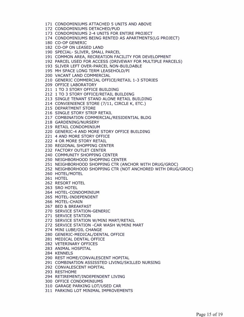
171 CONDOMINIUMS ATTACHED 5 UNITS AND ABOVE172 CONDOMINIUMS DETACHED/PUD173 CONDOMINIUMS 2-4 UNITS FOR ENTIRE PROJECT174 CONDOMINIUMS BEING RENTED AS APARTMENTS(LG PROJECT)180 CO-OP GENERIC182 CO-OP ON LEASED LAND190 SPECIAL- SLIVER, SMALL PARCEL191 COMMON AREA, RECREATION FACILITY FOR DEVELOPMENT192 PARCEL USED FOR ACCESS (DRIVEWAY FOR MULTIPLE PARCELS)193 SLIVER LEFT OVER-PARCEL NON-BUILDABLE195 MH SPACE LONG TERM LEASEHOLD/PI200 VACANT LAND COMMERCIAL210 GENERIC COMMERCIAL OFFICE/RETAIL 1-3 STORIES209 OFFICE LABORATORY211 1 TO 3 STORY OFFICE BUILDING212 1 TO 3 STORY OFFICE/RETAIL BUILDING213 SINGLE TENANT STAND ALONE RETAIL BUILDING214 CONVIENIENCE STORE (7/11, CIRCLE K, ETC.)215 DEPARTMENT STORE216 SINGLE STORY STRIP RETAIL217 COMBINATION COMMERCIAL/RESIDENTIAL BLDG218 GARDENING/NURSERY219 RETAIL CONDOMINIUM220 GENERIC-4 AND MORE STORY OFFICE BUILDING221 4 AND MORE STORY OFFICE222 4 OR MORE STORY RETAIL230 REGIONAL SHOPPING CENTER232 FACTORY OUTLET CENTER240 COMMUNITY SHOPPING CENTER250 NEIGHBORHOOD SHOPPING CENTER251 NEIGHBORHOOD SHOPPING CTR (ANCHOR WITH DRUG/GROC)252 NEIGHBORHOOD SHOPPING CTR (NOT ANCHORED WITH DRUG/GROC)260 HOTEL/MOTEL261 HOTEL 262 RESORT HOTEL263 SRO HOTEL264 HOTEL-CONDOMINIUM265 MOTEL-INDEPENDENT266 MOTEL-CHAIN267 BED & BREAKFAST270 SERVICE STATION-GENERIC271 SERVICE STATION272 SERVICE STATION W/MINI MART/RETAIL272 SERVICE STATION -CAR WASH W/MINI MART274 MINI LUBE/OIL CHANGE280 GENERIC-MEDICAL/DENTAL OFFICE281 MEDICAL DENTAL OFFICE282 VETERINARY OFFICES283 ANIMAL HOSPITAL284 KENNELS290 REST HOME/CONVALESCENT HOPITAL291 COMBINATION ASSISSTED LIVING/SKILLED NURSING292 CONVALESCENT HOPITAL293 RESTHOME294 RETIREMENT/INDEPENDENT LIVING300 OFFICE CONDOMINIUMS310 GARAGE PARKING LOT/USED CAR 311 PARKING LOT MINIMAL IMPROVEMENTS
Page 15 of 19
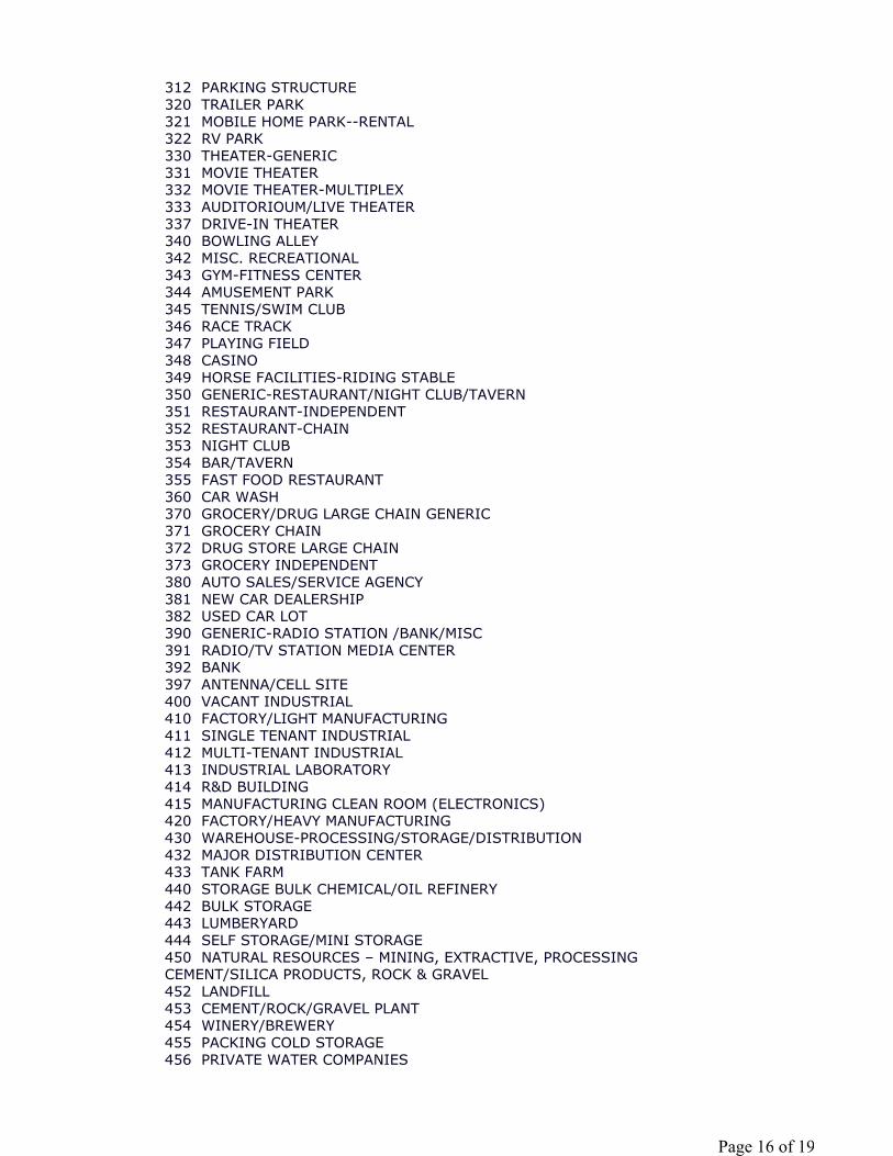
312 PARKING STRUCTURE 320 TRAILER PARK321 MOBILE HOME PARK--RENTAL322 RV PARK330 THEATER-GENERIC331 MOVIE THEATER332 MOVIE THEATER-MULTIPLEX333 AUDITORIOUM/LIVE THEATER337 DRIVE-IN THEATER340 BOWLING ALLEY342 MISC. RECREATIONAL343 GYM-FITNESS CENTER344 AMUSEMENT PARK345 TENNIS/SWIM CLUB346 RACE TRACK347 PLAYING FIELD348 CASINO349 HORSE FACILITIES-RIDING STABLE350 GENERIC-RESTAURANT/NIGHT CLUB/TAVERN351 RESTAURANT-INDEPENDENT352 RESTAURANT-CHAIN353 NIGHT CLUB354 BAR/TAVERN355 FAST FOOD RESTAURANT360 CAR WASH370 GROCERY/DRUG LARGE CHAIN GENERIC371 GROCERY CHAIN372 DRUG STORE LARGE CHAIN373 GROCERY INDEPENDENT380 AUTO SALES/SERVICE AGENCY381 NEW CAR DEALERSHIP382 USED CAR LOT390 GENERIC-RADIO STATION /BANK/MISC391 RADIO/TV STATION MEDIA CENTER392 BANK397 ANTENNA/CELL SITE400 VACANT INDUSTRIAL410 FACTORY/LIGHT MANUFACTURING411 SINGLE TENANT INDUSTRIAL412 MULTI-TENANT INDUSTRIAL413 INDUSTRIAL LABORATORY414 R&D BUILDING415 MANUFACTURING CLEAN ROOM (ELECTRONICS)420 FACTORY/HEAVY MANUFACTURING430 WAREHOUSE-PROCESSING/STORAGE/DISTRIBUTION432 MAJOR DISTRIBUTION CENTER433 TANK FARM440 STORAGE BULK CHEMICAL/OIL REFINERY442 BULK STORAGE443 LUMBERYARD444 SELF STORAGE/MINI STORAGE450 NATURAL RESOURCES – MINING, EXTRACTIVE, PROCESSING CEMENT/SILICA PRODUCTS, ROCK & GRAVEL452 LANDFILL453 CEMENT/ROCK/GRAVEL PLANT454 WINERY/BREWERY455 PACKING COLD STORAGE456 PRIVATE WATER COMPANIES
Page 16 of 19

457 POWER PLANTS458 OPEN STORAGE460 AUTOMOTIVE REPAIR GARAGES462 TRUCK TERMINAL463 AUTO WRECKING YARDS464 SHIPYARD, SHIP/BOAT REPAIR FACILITIES465 AIRPLANE HANGER470 INDUSTRIAL CONDOS490 MISC INDUSTRIAL/SPECIAL LAND500 IRRIGATED FARM VACANT WATER AVAILABLE510 CITRUS520 AVOCADO530 VINES532 VINEYARD533 VINEYARD WITH WINE TASTING ROOM540 TREES MISC (OTHER THAN CITRUS OR AVOCADO)550 LIVESTOCK560 POULTRY570 IRRIGATED CROPS OTHER VEGETABLE, FLORAL, FEEDING (HAY OR SEED CROPS)580 GROWING HOUSES590 MISC. AGRICULTURAL610 1 – 10 ACRES NON-IRRIGATED620 11 – 40 ACRES NON-IRRIGATED630 41 – 160 ACRES NON-IRRIGATED640 161 – 360 ACRES NON-IRRIGATED650 361 ACRES & UP NON-IRRIGATED700 INSTITUTIONAL-VACANT710 CHURCH720 CHURCH RECTORY, PARKING & OTHER CHURCH RELATED USE730 CEMETARY740 MAUSOLEUM750 MORTUARY760 PUBLIC BUILDING (SCHOOL, FIREHOUSE, LIBRARY, ETC)770 HOSPITAL780 PRIVATE SCHOOLS & FACILITIES782 PRESCHOOL AND CHILDCARE FACILITY783 FRATERNITY/SORORITY HOUSE784 DORMITORIES-PRIVATE790 MISC. INSTITUTIONAL-GENERIC792 CORRECTIONAL FACILITY800 VACANT RECREATIONAL810 MEETING HALL, GYM - GENERIC811 MEETING HALL812 AMPHITHEATER813 ARENA/STADIUM820 GOLF COURSE823 DRIVING RANGE830 MARINA DOCKS840 RECREATIONAL CAMPS850 NON-TAXABLE 851 MILITARY BASE852 STATE PARK853 COUNTY PARK854 CITY PARK855 NATIONAL FOREST856 WATER TANK SITE857 INDIAN RESERVATION
Page 17 of 19
NUCLEUS_SI (Double)
NUCLEUS__1 (Double)
NUCLEUS__2 (String)
OVERLAY_JU (String)
858 NATIONAL WILDLIFE REFUGE859 MISC NON-TAXABLE IMPROVEMENT867 STATE ASSESSED860 OPEN SPACE 861 OPEN SPACED OWNED BY AN HOA (OR SIMILAR)862 OPEN SPACE OWNED BY DEVELOPER864 OPEN SPACE ESMT-IN FAVOR OF GOVERNMENT 865 LAND BANK-CREDITS BEING SOLD866 MITIGATION LAND- CREDITS USED870 AGRICULTURAL PRESERVE (NOT UNDER CONTRACT)880 AGRICULTURAL PRESERVE (UNDER CONTRACT)881 AGRICULTURAL PRESERVE WITH HOUSE882 AGRICULTRAL PRESERVE AVOCADO883 AGRICULTURAL PRESERVE CITRUS884 AGRICULTRAL PRESERVE GRAZING885 VINEYARD UNDER CONTRACT887 MILLS ACT (SINGLE FAM OWNER OCCUPIED)888 MILLS ACT (OTHER THAN SINGLE FAM OWNER OCCUPIED)890 MISCELLANEOUS/SPECIAL900 VACANT TAXABLE GOVT. OWNED PROPERY910 IMPROVED TAXABLE GOVT OWNED PROPERTY
Where the parcel contains an address range, this number represents the starting, lowest, number of the range.
Field updated weekly from Assessor's Master Property Record (MPR) file.
Where the parcel contains an address range, this number represents the ending, highest, number of the range.
Field updated weekly from Assessor's Master Property Record (MPR) file.
If there is a fraction at the end of a range, e.g. 1424 - 1426 1/2
Overlay Jurisdiction.Field calculated from spatial overlay of parcel centroid with JUR_MUNICIPAL Feature Class.
Code; JurisdictionCB; CarlsbadCN; UnincorporatedCO; CoronadoCV; Chula VistaDM; Del MarEC; El CajonEN; EncinitasES; EscondidoIB; Imperial BeachLG; Lemon GroveLM; La MesaNC; National City
Page 18 of 19
SHAPE_LEN (Double)
Metadata Last Update: 2015-10-05Regional GIS Data Warehouse (RGDW) Publication Stylesheet 1.4
OC; OceansidePW; PowaySD; San DiegoSM; San MarcosSO; Solana BeachST; SanteeVS; Vista
Page 19 of 19

UUP MASTER PLAN UPDATE – FACTORS AND METHOD
SECTION 10 RESOURCE_CONSERVATION_AREAS

CMTY_RESOURCE_CONSERV_AREAS
TagsRCA, General Plan Conservation Element, public acquisition, open space easements, land use
controls, cluster zoning, large lot zoning, scenic or natural resource preservation overlay zones, resource conservation areas, groundwater problem areas, coastal wetlands, native wildlife habitat, construction quality sand areas, littoral sand areas, astronomical dark sky areas, unique geological
formations, and significant archaeological and historical sites
Summary:
Feature Type: Polygon
Number of Records: 193
Publication Date: 2009-06-11
Date of Data (Temporal Period Extent): 2009-06-11
Extent: San Diego County
Extent in Longitude Latitude
North 33.512045
South 32.530187
Extent in the item's coordinate system
North 2129938.999910
South 1775313.499868
Description:
To identify and describe the County's resource conservation areas (RCA)
West -117.597988 East -116.080174
West 6150765.499856 East 6613431.000030
This overlay identifies lands requiring special attention in order to conserve resources in a manner best satisfying public and private objectives. The appropriate implementation actions will vary depending upon the conservation objectives of each resource but may include: public acquisition, establishment of open space easements, application or special land use controls such as cluster zoning, large lot zoning, scenic or natural resource preservation overlay zones, or by incorporating special design considerations into subdivision maps or special
Page 1 of 4
4/3/2015file:///C:/Users/lwedley/AppData/Local/Temp/arcC9D4/tmp3A51.tmp.htm
Credits:
Use Limitation:
Topics and Keywords
Topic Categories: Environment Location Planning Cadastral
Themes:
RCA, General Plan Conservation Element, public acquisition, open space easements, land use controls, cluster zoning, large lot zoning, scenic or natural resource preservation overlay zones, resource conservation areas, groundwater problem areas, coastal wetlands, native wildlife habitat, construction quality sand areas, littoral sand areas, astronomical dark sky areas, unique geological formations, and significant archaeological and historical sites
Places:
County of San Diego, California
Resource Details:
Status: On GoingType: VectorUpdate Frequency: As NeededNext Update: Not specified
use permits. Resource conservation areas shall include but are not limited to groundwater problem areas, coastal wetlands, native wildlife habitat, construction quality sand areas, littoral sand areas, astronomical dark sky areas, unique geological formations, and significant archaeological and historical sites. Text regarding RCAs can be found in the Conservation Element of the County of San Diego's General Plan. For a comprehensive description of the County of San Diego General Plan and a information about the RCAs, refer to: http://www.sdcounty.ca.gov/pds/generalplan.html
County of San Diego, Department of Public Works, County of San Diego, Planning and Development Services, LUEG-GIS Service.
THIS MAP/DATA IS PROVIDED WITHOUT WARRANTY OF ANY KIND, EITHER EXPRESS OR IMPLIED, INCLUDING BUT NOT LIMITED TO, THE IMPLIED WARRANTIES OF MERCHANTABILITY AND FITNESS FOR A PARTICULAR PURPOSE. Note: This product may contain information from the SANDAG Regional Information System which cannot be reproduced without the written permission of SANDAG. This product may contain information reproduced with permission granted by Rand McNally & Company® to SanGIS. This map is copyrighted by Rand McNally & Company®. It is unlawful to copy or reproduce all or any part thereof, whether for personal use or resale, without the prior, written permission of Rand McNally & Company®. Copyright SanGIS 2011 - All Rights Reserved. Full text of this legal notice can be found at:http://www.sangis.org/Legal_Notice.htm
Page 2 of 4
4/3/2015file:///C:/Users/lwedley/AppData/Local/Temp/arcC9D4/tmp3A51.tmp.htm
Spatial Reference System:
Type: ProjectedReference: GCS_North_American_1983Projection: NAD_1983_StatePlane_California_VI_FIPS_0406_Feet
Identifier: 2230Codespace: EPSGVersion: 7.11.2
Contacts:
Point of Contact
Melanie Casey, Senior GIS AnalystCounty of San Diego, Planning & Development Services, LUEG-GIS Service5510 Overland Ave, Suite 310San Diego, California. 92123
[email protected](858) 414-7761
Distributor
SanGIS5510 Overland Ave, Suite 230San Diego, California. [email protected]:(858) 874-7000
Distribution Ordering Instructions:
Online Ordering Description:
Fields:
Overview:
__FID (OID)
Refer to SanGIS website (http://www.sangis.org/services/index.html) to obtain further information on mapping and data extraction services available from SanGIS.
Downloadable as a Shapefile from http://www.sangis.org/download/index.html
To identify and describe the County's resource conservation areas (RCA), lands requiring special attention in order to conserve resources in a manner best satisfying public and private objectives
RCA_NAME is name of Resource Conservation Area NameRCA_NUM is Resource Conservation Area NumberRCA_NUM is Additional_RCA information
Page 3 of 4
4/3/2015file:///C:/Users/lwedley/AppData/Local/Temp/arcC9D4/tmp3A51.tmp.htm
Shape (Geometry)
RCA_NAME (String)
RCA_NUM (Double)
ADD_RCA (String)
Shape_Area (Double)
SHAPE_LEN (Double)
Metadata Last Update: 2015-04-03Regional GIS Data Warehouse (RGDW) Publication Stylesheet 1.4
Internal feature number.
Feature geometry.
Name of RCA
Number associated with RCA. Value of RCA_NUM has one-to-one relationship to attribute table's RCA_NAME
RCA_NUM, RCA_NAME
Additional information regarding RCA
Area of feature in internal units squared.
Page 4 of 4
4/3/2015file:///C:/Users/lwedley/AppData/Local/Temp/arcC9D4/tmp3A51.tmp.htm

UUP MASTER PLAN UPDATE – FACTORS AND METHOD
SECTION 11 ROADS_ALL
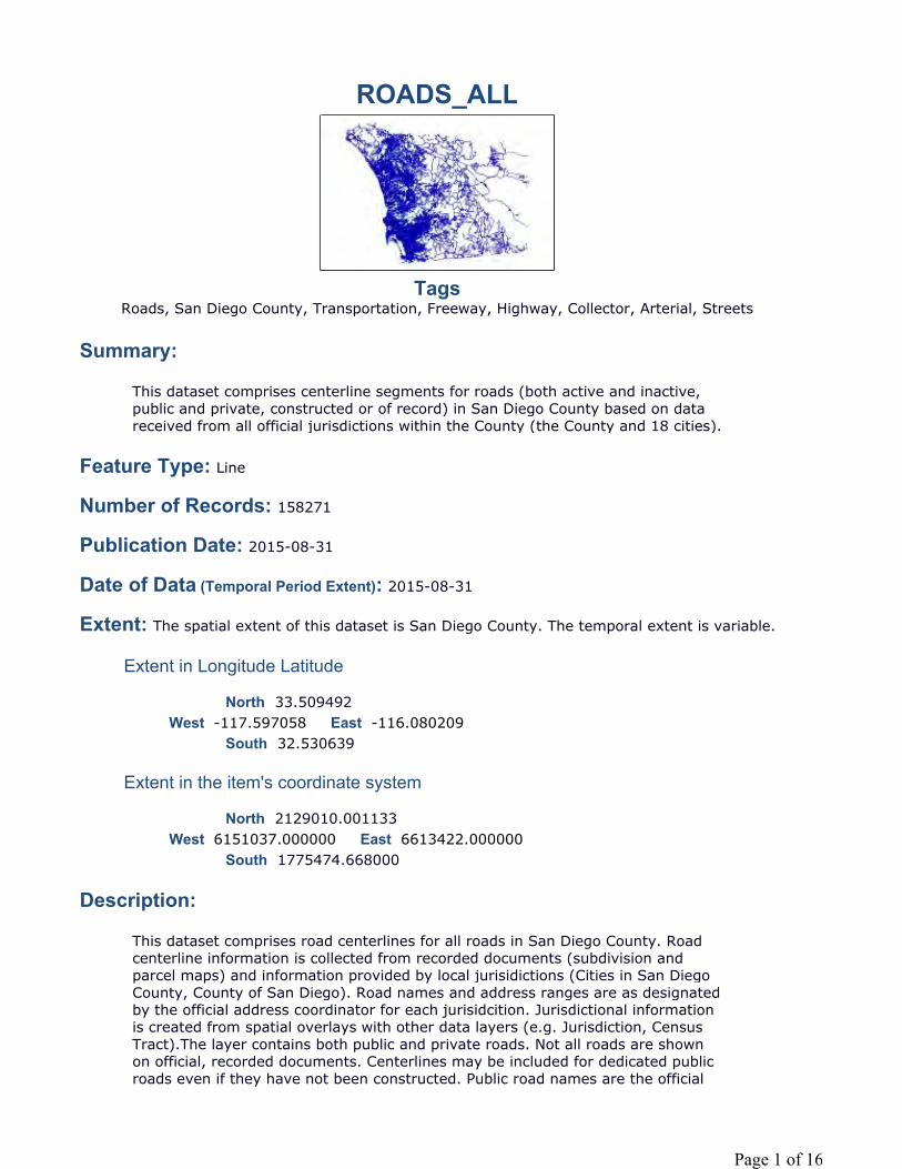
ROADS_ALL
TagsRoads, San Diego County, Transportation, Freeway, Highway, Collector, Arterial, Streets
Summary:
Feature Type: Line
Number of Records: 158271
Publication Date: 2015-08-31
Date of Data (Temporal Period Extent): 2015-08-31
Extent: The spatial extent of this dataset is San Diego County. The temporal extent is variable.
Extent in Longitude Latitude
North 33.509492
South 32.530639
Extent in the item's coordinate system
North 2129010.001133
South 1775474.668000
Description:
This dataset comprises centerline segments for roads (both active and inactive, public and private, constructed or of record) in San Diego County based on data received from all official jurisdictions within the County (the County and 18 cities).
West -117.597058 East -116.080209
West 6151037.000000 East 6613422.000000
This dataset comprises road centerlines for all roads in San Diego County. Road centerline information is collected from recorded documents (subdivision and parcel maps) and information provided by local jurisidictions (Cities in San Diego County, County of San Diego). Road names and address ranges are as designated by the official address coordinator for each jurisidcition. Jurisdictional information is created from spatial overlays with other data layers (e.g. Jurisdiction, Census Tract).The layer contains both public and private roads. Not all roads are shown on official, recorded documents. Centerlines may be included for dedicated public roads even if they have not been constructed. Public road names are the official
Page 1 of 16
Credits:
Use Limitation:
Topics and Keywords
Topic Categories: Planning Cadastral Transportation
Themes:
Roads, Streets, Transportation, Routes, Centerlines, Highways, Freeways, Expressways, Collector
Places:
California, County of San Diego, Carlsbad, Coronado, Chula Vista, Del Mar, El Cajon, Encinitas, Escondido, Imperial Beach, Lemon Grove, La Mesa, National City, Oceanside, Poway, San Diego, San Marcos, Solana Beach, Santee, Vista
Resource Details:
names as maintained by the addressing authority for the jurisdiction in which the road is located. Official road names may not match the common or local name used to identify the road (e.g. State Route 94 is the official name of certain road segments commonly referred to as Campo Road).Private roads are either named or unnamed. Named private roads are as shown on official recorded documents or as directed by the addressing authority for the jurisdiction in which the road is located. Unnamed private roads are included where requested by the local jurisidiction or by SanGIS JPA members (primarily emergency response dispatch agencies). Roads are comprised of road segments that are individually identified by a unique, and persistent, ID (ROADSEGID). Roads segments are terminated where they intersect with each other, at jurisdictional boundaries (i.e. city limits), certain census tract and law beat boundaries, at locations where road names change, and at other locations as required by SanGIS JPA members. Each road segment terminates at an intersection point that can be found in the ROADS_INTERSECTION layer.Road centerlines do not necessarily follow the centerline of dedicated rights-of-way (ROW). Centerlines are adjusted as needed to fit the actual, constructed roadway. However, many road centerline segments are created intially based on record documents prior to construction and may not have been updated to meet as-built locations. Please notify SanGIS if the actual location differs from that shown. See the SanGIS website for contact information and reporting problems (http://www.sangis.org/contact/problem.html).Note, the road speeds in this layer are based on road segment class and were published as part of an agreement between San Diego Fire-Rescue, the San Diego County Sheriff's Department, and SanGIS. The average speed is based on heavy fire vehicles and may not represent the posted speed limit.
SanGIS using information from documents recorded with the County of San Diego and the addressing authorities in the 18 cities in San Diego County.
Data is generalized and created for use in regional projects. Please refer to SanGIS GIS data end user use agreement and disclaimer which is available at the following: http://www.sangis.org/Legal_Notice.htm. See Metadata Description item for futher information.
Page 2 of 16
Status: On GoingType: VectorUpdate Frequency: WeeklyNext Update: 2014-09-05
Spatial Reference System:
Type: ProjectedReference: GCS_North_American_1983Projection: NAD_1983_StatePlane_California_VI_FIPS_0406_Feet
Identifier: 2230Codespace: EPSGVersion: 7.9.4
Contacts:
Point of Contact
Operations Manager, Operations ManagerSanGIS5510 Overland Ave, Suite 230San Diego, California. 92123
[email protected](858) 874-7000
Distributor
SanGIS5510 Overland Avenue, Suite 230San Diego, California. 92123Data LibrarianData [email protected](858) 874-7000
Distribution Ordering Instructions:
Online Ordering Description:
Fields:
Overview:
Refer to SanGIS website (http://www.sangis.org/services/index.html) to obtainfurther information on mapping and data extraction services available from SanGIS.
The roads_all dataset is available for download as shapefile from http://www.sangis.org/download.index.html and roads can also be viewed on the SanGIS interactive webmap (http://sdgis.sandag.org;)
Page 3 of 16
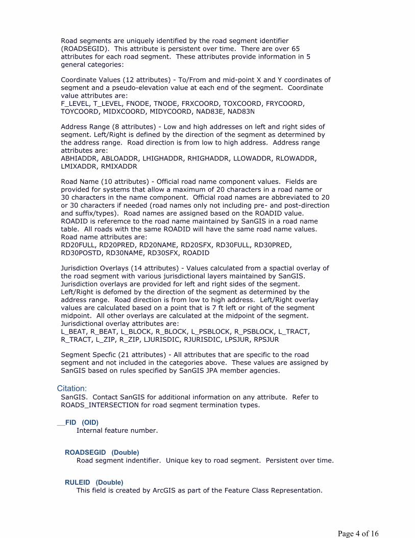
Citation:
__FID (OID)
ROADSEGID (Double)
RULEID (Double)
Road segments are uniquely identified by the road segment identifier (ROADSEGID). This attribute is persistent over time. There are over 65 attributes for each road segment. These attributes provide information in 5 general categories:
Coordinate Values (12 attributes) - To/From and mid-point X and Y coordinates of segment and a pseudo-elevation value at each end of the segment. Coordinate value attributes are:F_LEVEL, T_LEVEL, FNODE, TNODE, FRXCOORD, TOXCOORD, FRYCOORD, TOYCOORD, MIDXCOORD, MIDYCOORD, NAD83E, NAD83N
Address Range (8 attributes) - Low and high addresses on left and right sides of segment. Left/Right is defined by the direction of the segment as determined by the address range. Road direction is from low to high address. Address range attributes are:ABHIADDR, ABLOADDR, LHIGHADDR, RHIGHADDR, LLOWADDR, RLOWADDR, LMIXADDR, RMIXADDR
Road Name (10 attributes) - Official road name component values. Fields are provided for systems that allow a maximum of 20 characters in a road name or 30 characters in the name component. Official road names are abbreviated to 20 or 30 characters if needed (road names only not including pre- and post-direction and suffix/types). Road names are assigned based on the ROADID value. ROADID is referemce to the road name maintained by SanGIS in a road name table. All roads with the same ROADID will have the same road name values. Road name attributes are:RD20FULL, RD20PRED, RD20NAME, RD20SFX, RD30FULL, RD30PRED, RD30POSTD, RD30NAME, RD30SFX, ROADID
Jurisdiction Overlays (14 attributes) - Values calculated from a spactial overlay of the road segment with various jurisdictional layers maintained by SanGIS. Jurisdiction overlays are provided for left and right sides of the segment. Left/Right is defomed by the direction of the segment as determined by the address range. Road direction is from low to high address. Left/Right overlay values are calculated based on a point that is 7 ft left or right of the segment midpoint. All other overlays are calculated at the midpoint of the segment. Jurisdictional overlay attributes are:L_BEAT, R_BEAT, L_BLOCK, R_BLOCK, L_PSBLOCK, R_PSBLOCK, L_TRACT, R_TRACT, L_ZIP, R_ZIP, LJURISDIC, RJURISDIC, LPSJUR, RPSJUR
Segment Specfic (21 attributes) - All attributes that are specific to the road segment and not included in the categories above. These values are assigned by SanGIS based on rules specified by SanGIS JPA member agencies.
SanGIS. Contact SanGIS for additional information on any attribute. Refer to ROADS_INTERSECTION for road segment termination types.
Internal feature number.
Road segment indentifier. Unique key to road segment. Persistent over time.
This field is created by ArcGIS as part of the Feature Class Representation.
Page 4 of 16

L_BEAT (Integer)
POSTDATE (Date)
LPSJUR (String)
PENDING (String)
R_ZIP (Double)
TNODE (Double)
RHIGHADDR (Double)
Law (police) beat number on left side of road. Value derived from a spatial overlay of the LAW_BEATS layer at a point 7' left of the segment midpoint.
Identifies last date that road segment was changed
Public safety jurisdiction code on left side of road. Value derived from a spatial overlay of the JUR_PUBLIC_SAFETY layer at a point 7' left of the segment midpoint.
Code; DescriptionCB; CarlsbadCN; UnincorporatedCO; CoronadoCV; Chula VistaDM; Del MarEC; El CajonEN; EncinitasES; EscondidoIB; Imperial BeachLG; Lemon GroveLM; La MesaNC; National CityOC; OceansidePW; PowaySD; San DiegoSM; San MarcosSO; Solana BeachST; SanteeVS; Vista
Recording status indicator of map creating this road segmentY=yes, recording pending N=no, map recorded or not available
Five digit zip code number on right side of road. Value derived from a spatial overlay of the ZIPCODE layer at a point 7' right of the segment midpoint.
ID of the intersection point at the TO point (end) of the segment. Refers to the unique intersection point ID attribute (INTERID) in the ROADS_INTERSECTION layer.Each road segment has an associated intersection point at the start and end points.
Page 5 of 16
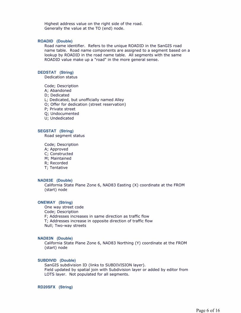
ROADID (Double)
DEDSTAT (String)
SEGSTAT (String)
NAD83E (Double)
ONEWAY (String)
NAD83N (Double)
SUBDIVID (Double)
RD20SFX (String)
Highest address value on the right side of the road.Generally the value at the TO (end) node.
Road name identifier. Refers to the unique ROADID in the SanGIS road name table. Road name components are assigned to a segment based on a lookup by ROADID in the road name table. All segments with the same ROADID value make up a "road" in the more general sense.
Dedication status
Code; DescriptionA; AbandonedD; DedicatedL; Dedicated, but unofficially named AlleyO; Offer for dedication (street reservation)P; Private streetQ; UndocumentedU; Undedicated
Road segment status
Code; Description A; ApprovedC; ConstructedM; MaintainedR; RecordedT; Tentative
California State Plane Zone 6, NAD83 Easting (X) coordinate at the FROM (start) node
One way street code Code; DescriptionF; Addresses increases in same direction as traffic flowT; Addresses increase in opposite direction of traffic flowNull; Two-way streets
California State Plane Zone 6, NAD83 Northing (Y) coordinate at the FROM (start) node
SanGIS subdivision ID (links to SUBDIVISION layer).Field updated by spatial join with Subdivision layer or added by editor from LOTS layer. Not populated for all segments.
Page 6 of 16
LLOWADDR (Double)
F_LEVEL (Integer)
Road Suffix (aka street type) for 20 character road name abbreviations -always two letters
Code; DescriptionAL; ALLEYAR; ARCADEAV; AVENUEBL; BOULEVARDBP; BIKEPATHBR; BRIDGEBY; BYPASSCE; CORTECG; CROSSINGCP; CAPECR; CIRCLECS; CRESCENTCT; COURTCV; COVECY; CAUSEWAYDR; DRIVEDY; DRIVEWAYEX; EXTENSIONEY; EXPRESSWAYFR; FERRYFY; FREEWAYHY; HIGHWAYIN; INTERCHANGELN; LANELP; LOOPML; MALLPA; PATHPE; POINTEPL; PLACEPS; PASSPT; POINTPY; PARKWAYPZ; PLAZARA; RAMPRD; ROADRW; ROWSQ; SQUAREST; STREETTL; TRAILTR; TERRACETT; TRUCKTRAILWK; WALKWY; WAY
Lowest address value on the left side of the road.Generally the value at the FROM (start) node.
Psuedo elevation value at the FROM (start) node of the segment.The F_LEVEL (from level) AND T_LEVEL (to level) attributes define relative vertical separation between road segments. Values range from 0 to 9 with 0 defining a road segment below ground level and level 1 are road segments
Page 7 of 16
RD30SFX (String)
usually at ground level. Values 2 to 9 define a relative vertical separation to the base ground level road segment. Value 2 segments would be above a value 1 segment but lower than a value 3 segments. An example would be the I-805/I-8 interchange across Mission Valley where the F_LEVEL and T_LEVEL values for the road segments through the interchange range from 1 to 4. An individual road segment can have different F_LEVEL and T_LEVEL values indicating a transition between vertical separations.
Abbreviated street name suffix (aka street type) for 30 character road names. That is, the part of the road name that describes the type of street. Up to four letter abbreviations are used according to the SanGIS standards manual as shown below. Does not necessarily match with US Postal Service suffix designations.
ALY: ALLEYARC: ARCADEAVE: AVENUEBP: BIKEPATHBLVD: BOULEVARDBRG: BRIDGEBYP: BYPASSCSWY: CAUSEWAYCIR: CIRCLECTE: CORTECT: COURTCV: COVE CRES: CRESCENTXING: CROSSINGDR: DRIVEDRWY: DRIVEWAYEXPY: EXPRESSWAYEXT: EXTENTIONFRY: FERRYFWY: FREEWAYGLEN: GLENHWY: HIGHWAYINTR: INTERCHANGELN: LANELOOP: LOOPMALL: MALLPKY: PARKWAYPASS: PASSPATH: PATHPL: PLACEPLZ: PLAZAPT: POINTPTE: POINTERAMP: RAMPRD: ROADROW: ROWSQ: SQUAREST: STREETTER: TERRACETRL: TRAILTKTL: TRUCKTRAILWALK: WALK
Page 8 of 16
RD30PRED (String)
RD20PRED (String)
TOXCOORD (Double)
MIDXCOORD (Double)
SPEED (Integer)
FRYCOORD (Double)
FRXCOORD (Double)
L_TRACT (Double)
WAY: WAY
One or two character abbreviation for pre-direction component (direction preceeding the road name) of road names abbreviated to 30 characters.
E; EastN; NorthS; SouthW; WestNE; NortheastNW; NorthwestSE; SoutheastSW; Southwest
One character abbreviation for pre-direction component (direction preceeding road name) of road names abbreviated to 20 characters.
E; EastN; North, Northwest or NortheastS; South, Southwest or SoutheastW; West
X (Easting) coordinate of the end (TO) point of the segment. California State Plane, Zone 6, NAD83
X (Easting) coordinate of the mid-point of the segment. California State Plane, Zone 6, NAD83
Average driving speed based on segment classification (SEGCLASS). This attribute is not intended to be the posted speed limit for the roads segment. SPEED is established by emergency vehicle dispatch agencies generally based on heavy fire vehicles in order to allow the Fire Department to determine realistic response times.
Y (Northing) coordinate of the start (FROM) point of the segment. California State Plane, Zone 6, NAD83
X (Easting) coordinate of the start (FROM) point of the segment. California State Plane, Zone 6, NAD83
US 2010 census tract number on left side of road. Value derived from a spatial overlay of the CENSUS_TRACT layer at a point 7' left of the segment midpoint.
Page 9 of 16
R_TRACT (Double)
CARTO (String)
SEGCLASS (String)
RD20NAME (String)
T_LEVEL (Integer)
US 2010 census tract number on right side of road. Value derived from a spatial overlay of the CENSUS_TRACT layer at a point 7' right of the segment midpoint.
Cartographic display indicator. Used to provide more appropriate cartographic representation. Generally the same as SEGCLASS. Not rigorously maintained.
Code; Description1; Freeway/Expressway2; Highway/State Routes3; Minor Highway/Major Roads4; Arterial or Collector5; Local Street6; Unpaved Road7; Private Road8; Freeway Transition Ramp9; Freeway On/Off RampA; AlleyH; Speed HumpM; Military Street within BaseP; Paper StreetQ; UndocumentedW; Walkway
Segment class
Code; Description1; Freeway/Expressway2; Highway/State Routes3; Minor Highway/Major Roads4; Arterial or Collector5; Local Street6; Unpaved Road7; Private Road8; Freeway Transition Ramp9; Freeway On/Off RampA; AlleyH; Speed HumpM; Military Street within BaseP; Paper StreetQ; UndocumentedW; WalkwayZ; Named Private Street
Official road name abbreviated to 20 characters according to rules established in the SanGIS policy and procedures manual. Attribute maintained for compatibiltiy by older systems with limited length fields.
Page 10 of 16
RD30FULL (String)
RD30POSTD (String)
RD30NAME (String)
R_BEAT (Integer)
MIDYCOORD (Double)
ADDSEGDT (Date)
Psuedo elevation value at the TO (end) node of the segment.The F_LEVEL (from level) AND T_LEVEL (to level) attributes define relative vertical separation between road segments. Values range from 0 to 9 with 0 defining a road segment below ground level and level 1 are road segments usually at ground level. Values 2 to 9 define a relative vertical separation to the base ground level road segment. Value 2 segments would be above a value 1 segment but lower than a value 3 segments. An example would be the I-805/I-8 interchange across Mission Valley where the F_LEVEL and T_LEVEL values for the road segments through the interchange range from 1 to 4. An individual road segment can have different F_LEVEL and T_LEVEL values indicating a transition between vertical separations.
Road full name including pre-direction, suffix (type), and post-direction indicators. Road name component abbreviated to 30 characters per SanGIS policy and procedure manuals. Full field limited to 41 characters (2 each for pre- and post-direction, 4 for suffix, 30 for name, plus spaces)
Note that there are only a few road segments in the county that have road names longer than 30 characters
One or two character abbreviation for post-direction component (direction following the road name or suffix) of road names abbreviated to 30 characters.
E; EastN; NorthS; SouthW; WestNE; NortheastNW; NorthwestSE; SoutheastSW; Southwest
Offical name of road abbreviate to 30 characters. Does not include pre- and post-direction or suffix components.
Note that there are very few road names in the county that exceed 30 characters in length.
Law (police) beat number on right side of road. Value derived from a spatial overlay of the LAW_BEATS layer at a point 7' right of the segment midpoint.
Y (Northing) coordinate of the mid-point of the segment. California State Plane, Zone 6, NAD83
Date road segment was created
Page 11 of 16

TBMGRID (String)
FIREDRIV (String)
TBMPAGE (String)
R_BLOCK (Double)
L_BLOCK (Double)
RJURISDIC (String)
L_ZIP (Double)
Thomas Brothers Map grid designation. Letter value indicates row and number value indicates column.
Fire drivability as established by San Diego Fire-Rescue department. Used for routing. Exclusively for use by San Diego Fire-Rescue
Code: DescriptionY; YesN; No
Thomas Brothers Map page number created by an overlay of the mid-point of the road segment with the Thomas Brothers Map page layer.
US 2010 census block number on right side of road. Value derived from a spatial overlay of the CENSUS_BLOCK layer at a point 7' right of the segment midpoint.
US 2010 census block number on left side of road. Value derived from a spatial overlay of the CENSUS_BLOCK layer at a point 7' left of the segment midpoint.
Jurisdiction code on right side of road. Value derived from a spatial overlay of the JUR_MUNICIPAL layer at a point 7' right of the segment midpoint.
Code; DescriptionCB; CarlsbadCN; UnincorporatedCO; CoronadoCV; Chula VistaDM; Del MarEC; El CajonEN; EncinitasES; EscondidoIB; Imperial BeachLG; Lemon GroveLM; La MesaNC; National CityOC; OceansidePW; PowaySD; San DiegoSM; San MarcosSO; Solana BeachST; SanteeVS; Vista
Page 12 of 16

FNODE (Double)
RIGHTWAY (Integer)
LJURISDIC (String)
RPSJUR (String)
Five digit zip code number on left side of road. Value derived from a spatial overlay of the ZIPCODE layer at a point 7' left of the segment midpoint.
ID of the intersection point at the FROM point (start) of the segment. Refers to the unique intersection point ID attribute (INTERID) in the ROADS_INTERSECTION layer.Each road segment has an associated intersection point at the start and end points.
Width of right-of-way
Jurisdiction code on right side of road. Value derived from a spatial overlay of the JUR_MUNICIPAL layer at a point 7' right of the segment midpoint.
Code; DescriptionCB; CarlsbadCN; UnincorporatedCO; CoronadoCV; Chula VistaDM; Del MarEC; El CajonEN; EncinitasES; EscondidoIB; Imperial BeachLG; Lemon GroveLM; La MesaNC; National CityOC; OceansidePW; PowaySD; San DiegoSM; San MarcosSO; Solana BeachST; SanteeVS; Vista
Public safety jurisdiction code on right side of road. Value derived from a spatial overlay of the JUR_PUBLIC_SAFETY layer at a point 7' right of the segment midpoint.
Code; DescriptionCB; CarlsbadCN; UnincorporatedCO; CoronadoCV; Chula VistaDM; Del MarEC; El CajonEN; EncinitasES; EscondidoIB; Imperial Beach
Page 13 of 16
Shape (Geometry)
TOYCOORD (Double)
OBMH (String)
LHIGHADDR (Double)
ABHIADDR (Double)
FUNCLASS (String)
LG; Lemon GroveLM; La MesaNC; National CityOC; OceansidePW; PowaySD; San DiegoSM; San MarcosSO; Solana BeachST; SanteeVS; Vista
Feature geometry shape (multipoint, polyline, or polygon)
Y (Northing) coordinate of the end (TO) point of the segment. California State Plane, Zone 6, NAD83
On base military housing indicator (Y=yes or N=no)
Highest address value on the left side of the road.Generally the value at the TO (end) node.
Absolute high address of road segment regardless of left or right side.
Functional Class
Code; Description1; Freeway to freeway ramp2; Light (2-lane) collector street3; Rural collector road4; Major road/4-lane major road5; Rural light collector/local road6; Prime (primary) arterial7; Private street8; Recreational parkway9; Rural mountain roadA; AlleyB; Class I bicycle pathC; Collector/4-lane collector streetD; Two-lane major streetE; ExpresswayF; FreewayL; Local street/cul-de-sacM; Military street within baseP; Paper streetQ; UndocumentedR; Freeway/expressway on/off rampS; Six-lane major street
Page 14 of 16
R_PSBLOCK (Double)
TBMQUAD (String)
POSTID (String)
RD20FULL (String)
L_PSBLOCK (Double)
RLOWADDR (Double)
RMIXADDR (String)
T; TransitwayU; Unpaved roadW; Pedestrianway/bikeway
Public Safety Census Block
Value derived from a 7' offset from the midpoint of the road centerline to the SanGIS pseudo Census Blocks layer right of the road centerline.
These are “Pseudo” census blocks created by SanGIS and used exclusively for San Diego Police Department crime statistics. Usually the PSBLOCK will be the same as the census block but in some cases the census block is divided into two or more smaller portions so that no block spans two police beats. The Pseudo blocks are not published in the regular census block layer.
Thomas Brothers quad value. Incomplete and no longer maintained. Thomas Bothers no longer publishes quad values. Attribute retained for use by legacy systems.
SanGIS internal identifier for last person or process to change road segment
Road full name including pre-direction and suffix (type). Road name component abbreviated to 20 characters per SanGIS policy and procedure manuals. Full field limited to 25 characters (1 for pre-direction, 2 for suffix, 20 for name, plus spaces). Post direction indicator is not included.
Maintained for legacy system compatibility.
Public Safety Census Block
Value derived from a 7' offset from the midpoint of the road centerline to the SanGIS pseudo Census Blocks layer left of the road centerline.
These are “Pseudo” census blocks created by SanGIS and used exclusively for San Diego Police Department crime statistics. Usually the PSBLOCK will be the same as the census block but in some cases the census block is divided into two or more smaller portions so that no block spans two police beats. The Pseudo blocks are not published in the regular census block layer.
Lowest address value on the right side of the road.Generally the value at the FROM (start) node.
Indicator showing whether odd and even (mixed) address are both shown on the right side of road.Y=yes - right side addresses are both odd and even numbersN=no - right side addresses are only odd or only even numbers
Page 15 of 16
ABLOADDR (Double)
LMIXADDR (String)
LENGTH (Double)
SHAPE_LEN (Double)
Metadata Last Update: 2015-08-31Regional GIS Data Warehouse (RGDW) Publication Stylesheet 1.4
Absolute low address of road segment regardless of left or right side.
Indicator showing whether odd and even (mixed) address are both shown on the left side of road.Y=yes - left side addresses are both odd and even numbersN=no - left side addresses are only odd or only even numbers
Road segment length
Page 16 of 16

UUP MASTER PLAN UPDATE – FACTORS AND METHOD
SECTION 12 ROADS_INTERSECTION
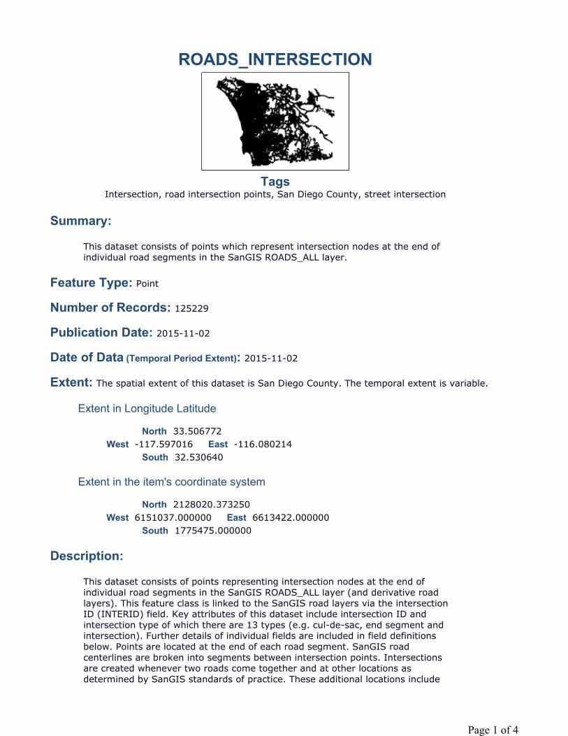
ROADS_INTERSECTION
TagsIntersection, road intersection points, San Diego County, street intersection
Summary:
Feature Type: Point
Number of Records: 125229
Publication Date: 2015-11-02
Date of Data (Temporal Period Extent): 2015-11-02
Extent: The spatial extent of this dataset is San Diego County. The temporal extent is variable.
Extent in Longitude Latitude
North 33.506772
South 32.530640
Extent in the item's coordinate system
North 2128020.373250
South 1775475.000000
Description:
This dataset consists of points which represent intersection nodes at the end of individual road segments in the SanGIS ROADS_ALL layer.
West -117.597016 East -116.080214
West 6151037.000000 East 6613422.000000
This dataset consists of points representing intersection nodes at the end of individual road segments in the SanGIS ROADS_ALL layer (and derivative road layers). This feature class is linked to the SanGIS road layers via the intersection ID (INTERID) field. Key attributes of this dataset include intersection ID and intersection type of which there are 13 types (e.g. cul-de-sac, end segment and intersection). Further details of individual fields are included in field definitions below. Points are located at the end of each road segment. SanGIS road centerlines are broken into segments between intersection points. Intersections are created whenever two roads come together and at other locations as determined by SanGIS standards of practice. These additional locations include
Page 1 of 4
Credits:
Use Limitation:
Topics and Keywords
Topic Categories: Transportation
Themes:
Intersection, road intersection, streets, nodes
Places:
California, County of San Diego, Carlsbad, Coronado, Chula Vista, Del Mar, El Cajon, Encinitas, Escondido, Imperial Beach, Lemon Grove, La Mesa, National City, Oceanside, Poway, San Diego, San Marcos, Solana Beach, Santee, Vista
Resource Details:
Status: On GoingType: VectorUpdate Frequency: WeeklyNext Update: Not specified
Spatial Reference System:
Type: ProjectedReference: GCS_North_American_1983Projection: NAD_1983_StatePlane_California_VI_FIPS_0406_Feet
Identifier: 2230Codespace: EPSGVersion: 7.9.4
Contacts:
Point of Contact
Operations Manager, Operations Manager
places where the road name changes, where a road traverses a jurisidictional boundary, in certain cases where a road goes from one police beat to another, and at other places as defined by the TYPE attribute.
SanGIS with assistance from SanGIS JPA member users.
Data is generalized and created for use in regional projects. Please refer to SanGIS GIS data end user use agreement and disclaimer which is available at the following: http://www.sangis.org/Legal_Notice.htm.
Page 2 of 4
SanGIS5510 Overland Avenue, Suite 230San Diego, California. 92123
[email protected](858) 874-7000
Distributor
SanGIS5510 Overland Avenue, Suite 230San Diego, California. 92123Data LibrarianData [email protected](858) 874-7000
Distribution Ordering Instructions:
Fields:
Overview:
Citation:
__FID (OID)
INTERID (Double)
X_COORD (Double)
RULEID (Double)
POSTDATE (Date)
Refer to SanGIS website (http://www.sangis.org/services/index.html) to obtain further information on mapping and data extraction services available from SanGIS.
Road intersection nodes are identified by the Intersection Identifier field -INTERID. The INTERID links to the TNODE and FNODE fields in the SanGIS ROADS_ALL layer (and derivative road layers).
The TYPE field identifies the intersection type. There are 13 types including intersection, cul-de-sac and end segment. TYPE provides the key to understanding why the road segment was terminated at that specific point.
None currently available
Internal feature number.
Intersection ID. Unique node identifier.Key field to link to TNODE and FNODE in road layers.
X (Easting) coordinate of point. California State Plane, Zone 6, NAD83
This field is created by ArcGIS as part of the Feature Class Representation.
Identifies last date that road intersection point was changed by SanGIS
Page 3 of 4
Y_COORD (Double)
Shape (Geometry)
PENDING (String)
TYPE (String)
POSTID (String)
Metadata Last Update: 2015-11-02Regional GIS Data Warehouse (RGDW) Publication Stylesheet 1.4
editing staff
Y (Northing) coordinate of point. California State Plane, Zone 6, NAD83
Feature geometry shape (multipoint, polyline, or polygon)
Map creating this road not yet recorded indicator (Y=yes or N=no)
Intersection type code. Code defines why the road segment is terminated at that point
Code, DescriptionB, Police law beat changeC, Cul-de-sac end pointD, Fire driveability attribute changeE, End of roadI, "Normal" Intersection of 3 or more segmentsJ, Jurisdiction boundary change (City/Muni only)N, Road Name ChangesP, Pseudo (Under/over crossings) R, Under Review (Type not yet verified)Q, Undocumented roads only (Dispatch agency use only)T, Census Tract changeX, Multiple types of changesZ, Fire Demand Zone change (City of San Diego use only)
Internal SanGIS ID of the last person or process to edit this intersection point
Page 4 of 4

UUP MASTER PLAN UPDATE – FACTORS AND METHOD
SECTION 13 STATE_WITH_COUNTY_BOUNDARIES
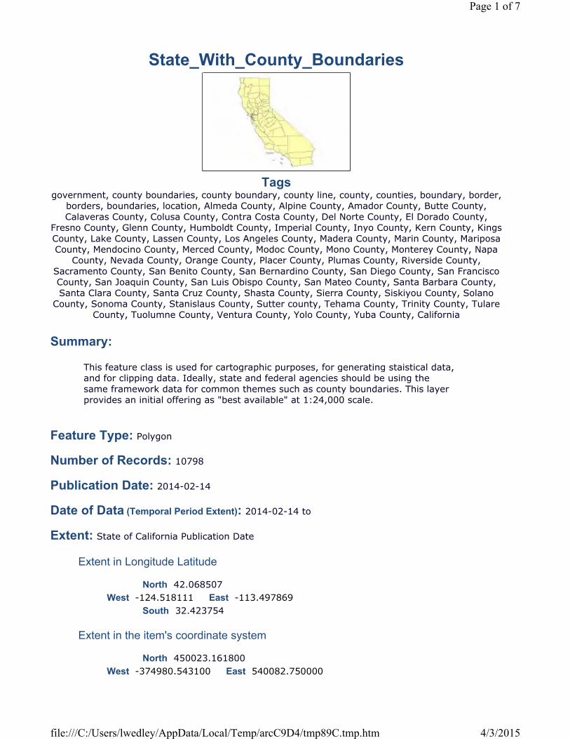
State_With_County_Boundaries
Tagsgovernment, county boundaries, county boundary, county line, county, counties, boundary, border,
borders, boundaries, location, Almeda County, Alpine County, Amador County, Butte County, Calaveras County, Colusa County, Contra Costa County, Del Norte County, El Dorado County,
Fresno County, Glenn County, Humboldt County, Imperial County, Inyo County, Kern County, Kings County, Lake County, Lassen County, Los Angeles County, Madera County, Marin County, Mariposa County, Mendocino County, Merced County, Modoc County, Mono County, Monterey County, Napa
County, Nevada County, Orange County, Placer County, Plumas County, Riverside County, Sacramento County, San Benito County, San Bernardino County, San Diego County, San Francisco County, San Joaquin County, San Luis Obispo County, San Mateo County, Santa Barbara County, Santa Clara County, Santa Cruz County, Shasta County, Sierra County, Siskiyou County, Solano
County, Sonoma County, Stanislaus County, Sutter county, Tehama County, Trinity County, Tulare County, Tuolumne County, Ventura County, Yolo County, Yuba County, California
Summary:
Feature Type: Polygon
Number of Records: 10798
Publication Date: 2014-02-14
Date of Data (Temporal Period Extent): 2014-02-14 to
Extent: State of California Publication Date
Extent in Longitude Latitude
North 42.068507
South 32.423754
Extent in the item's coordinate system
North 450023.161800
This feature class is used for cartographic purposes, for generating staistical data, and for clipping data. Ideally, state and federal agencies should be using the same framework data for common themes such as county boundaries. This layer provides an initial offering as "best available" at 1:24,000 scale.
West -124.518111 East -113.497869
West -374980.543100 East 540082.750000
Page 1 of 7
4/3/2015file:///C:/Users/lwedley/AppData/Local/Temp/arcC9D4/tmp89C.tmp.htm
South -604495.794300
Description:
Credits:
Use Limitation:
***** BACKGROUND *****In late 1996, the Dept of Conservation (DOC) surveyed state and federal agencies about the county boundary coverage they used. As a result, DOC adopted the 1:24,000 (24K) scale U.S. Bureau of Reclamation (USBR) dataset (USGS source) for their Farmland Mapping and Monitoring Program (FMMP) but with several modifications. Detailed documentation of these changes is provided by FMMP and included in the lineage section of the metadata. A dataset named cnty24k97_1 was made available (approximately 2004) through the California Department of Forestry and Fire Protection - Fire and Resource Assessment Program (CDF - FRAP) and the California Spatial Information Library (CaSIL). In late 2006, the Department of Fish and Game (DFG) reviewed cnty24k97_1. Comparisons were made to a high-quality 100K dataset (co100a/county100k from the former Teale Data Center GIS Solutions Group) and legal boundary descriptions from ( http://www.leginfo.ca.gov ). The cnty24k97_1 dataset was missing Anacapa and Santa Barbara islands. DFG added the missing islands using previously-digitized coastline data (coastn27 of State Lands Commission origin), corrected a few county boundaries, built region topology, added additional attributes, and renamed the dataset to county24k. In 2007, the California Mapping Coordinating Committee (CMCC) requested that the California Department of Forestry and Fire Protection (CAL FIRE) resume stewardship of the statewide county boundaries data. CAL FIRE adopted the changes made by DFG and collected additional suggestions for the county data from DFG, DOC, and local government agencies. CAL FIRE incorporated these suggestions into the latest revision, which has was renamed cnty24k09_1. ***** THIS VERSION*****This version of the county dataset was created as a result of an effort to improve the coastal linework. It uses the previous interior linework from the cnty24k13_1 data, but replaces the coastal linework (including islands and inlets) based on NOAA's ERMA coastal dataset (which used NAIP 2010). In addition to the improved linework, additional coding was added to differentiate inlets and bays, islands, and manmade structures such as piers and breakers. This dataset is one of several available datasets that were created as a group designed to work in topological sync with each other. These "paired" datasets include a basic county dataset (cnty14_1_basic), a basic state dataset (state14_1), an ocean dataset (ocean14_1), a 3 nautical mile CA coastal buffer (cnty14_1_coastbuff), and country/state datasets (both full and neighbor-only -cntrystate14_1_full and cntrystate14_1_neighbor, respectively). Further details about these paired datasets can be found in their respective metadata. This specific datasetrepresents the full detailed county dataset with all coding (islands, inlets, constructed features, etc). The user has the freedom to use this coding to create definition queries, symbolize, or dissolve to create a more generalized dataset as needed.
U.S. Bureau of Reclamation, California Department of Conservation, California Department of Fish and Game, California Department of Forestry and Fire Protection, National Oceanic and Atmospheric Administration
DISCLAIMER :
Page 2 of 7
4/3/2015file:///C:/Users/lwedley/AppData/Local/Temp/arcC9D4/tmp89C.tmp.htm
Topics and Keywords
Topic Categories: Boundaries
Themes:
government, county boundaries, county boundary, county line, county, counties, boundary, border, borders, boundaries, location
Places:
Almeda County, Alpine County, Amador County, Butte County, Calaveras County, Colusa County, Contra Costa County, Del Norte County, El Dorado County, Fresno County, Glenn County, Humboldt County, Imperial County, Inyo County, Kern County, Kings County, Lake County, Lassen County, Los Angeles County, Madera County, Marin County, Mariposa County, Mendocino County, Merced County, Modoc County, Mono County, Monterey County, Napa County, Nevada County, Orange County, Placer County, Plumas County, Riverside County, Sacramento County, San Benito County, San Bernardino County, San Diego County, San Francisco County, San Joaquin County, San Luis Obispo County, San Mateo County, Santa Barbara County, Santa Clara County, Santa Cruz County, Shasta County, Sierra County, Siskiyou County, Solano County, Sonoma County, Stanislaus County, Sutter county, Tehama County, Trinity County, Tulare County, Tuolumne County, Ventura County, Yolo County, Yuba County, California
Resource Details:
Status: Under DevelopmentType: VectorUpdate Frequency: IrregularNext Update: Not specified
Spatial Reference System:
Type: ProjectedReference: GCS_North_American_1983Projection: NAD_1983_California_Teale_Albers
Identifier: 3310
The State of California and the Department of Forestry and Fire Protection make no representations or warranties regarding the accuracy of data or maps. The user will not seek to hold the State or the Department liable under any circumstances for any damages with respect to any claim by the user or any third party on account of or arising from the use of data or maps. OTHER LIMITATIONS : There are no restrictions on distribution of the data by users. However, users are encouraged to refer others to the Department of Forestry and Fire Protection to acquire the data, in case updated data become available. The user will cite the California Department of Forestry and Fire Protection as the original source of the data, but will clearly denote cases where the original data have been altered, updated, or in any way changed from the original condition.
Page 3 of 7
4/3/2015file:///C:/Users/lwedley/AppData/Local/Temp/arcC9D4/tmp89C.tmp.htm

Codespace: EPSGVersion: 7.11.2
Contacts:
Point of Contact
FRAP Data Contact, FRAP Data ContactCALFIRE-FRAP1300 U StreetSacramento, CA. 95818
Distributor
CALFIRE-FRAP1300 U StreetSacramento, CA. 95818FRAP Data ContactFRAP Data [email protected]
Distribution Ordering Instructions:
Fields:
Overview:
Citation:
__FID (OID)
Shape (Geometry)
Dataset available from FRAP
The JUR_STATE dataset contains the following fields:TYPEISLANDWATERLOCASECOUNTY_ABBREVCOUNTYCOUNTY_CODECOUNTY_FIPSSANGIS_JUR_STATE_AREANAME
State of California GeoPortal Site (http://portal.gis.ca.gov/geoportal/catalog/main/home.page).
Internal feature number.
Feature geometry.
Page 4 of 7
4/3/2015file:///C:/Users/lwedley/AppData/Local/Temp/arcC9D4/tmp89C.tmp.htm
Shape_Area (Double)
WATER (String)
LOCASE (String)
COUNTY (Integer)
Area of feature in internal units squared.
For water features, further defines it as "Pacific Ocean", "San Francisco Bay", or "Misc Bay or Inlet".
Mainland and island features will be NULL.
Constructed features should never be NULL for this field – this coding distinguishes contructed features that stick out into the ocean from those that are within bays (ie ones to be potentially “left off” from those that should be potentially “dissolved or blended in”)
County Name, e.g. Mendocino County
County Code
Code, County_Code, County FIPS, Name1, 01, 001, Almeda2, 02, 003, Alpine3, 03, 005, Amador4, 04, 007, Butte5, 05, 009, Calaveras6, 06, 011, Colusa7, 07, 013, Contra Costa8, 08, 015, Del Norte9, 09, 017, El Dorado10, 10, 019, Fresno11, 11, 021, Glenn12, 12, 023, Humboldt13, 13, 025, Imperial14, 14, 027, Inyo15, 15, 029, Kern16, 16, 031, Kings17, 17, 033, Lake18, 18, 035, Lassen19, 19, 037, Los Angeles20, 20, 039, Madera21, 21, 041, Marin22, 22, 043, Mariposa23, 23, 045, Mendocino24, 24, 047, Merced25, 25, 049, Modoc26, 26, 051, Mono27, 27, 053, Monterey28, 28, 055, Napa29, 29, 057, Nevada30, 30, 059, Orange31, 31, 061, Placer32, 32, 063, Plumas33, 33, 065, Riverside34, 34, 067, Sacramento
Page 5 of 7
4/3/2015file:///C:/Users/lwedley/AppData/Local/Temp/arcC9D4/tmp89C.tmp.htm
COUNTY_ABB (String) TYPE (String)
COUNTY_COD (String) COUNTY_FIP (String) SANGIS_JUR (Double) ISLAND (String)
NAME (String)
35, 35, 069, San Benito36, 36, 071, San Bernardino37, 37, 073, San Diego38, 38, 075, San Francisco39, 39, 077, San Joaquin40, 40, 079, San Luis Obispo41, 41, 081, San Mateo42, 42, 083, Santa Barbara43, 43, 085, Santa Clara44, 44, 087, Santa Cruz45, 45, 089, Shasta46, 46, 091, Sierra47, 47, 093, Siskiyou48, 48, 095, Solano49, 49, 097, Sonoma50, 50, 099, Stanislaus51, 51, 101, Sutter52, 52, 103, Tehama53, 53, 105, Trinity54, 54, 107, Tulare55, 55, 109, Tuolumne56, 56, 111, Ventura57, 57, 113, Yolo58, 58, 115, Yuba
Feature Type. Either “Land”, “Water” or “Constructed”(ie Pier, Breaker, etc).
Mainland and islands are coded as “Land”. Mainland vs island can be distinguished by the ISLAND field.
Ocean and bays are coded as “Water”. Ocean vs Bay can be distinguished by the WATER field.
For island features, further defines it as "Channel Islands", "Farallon Islands", "Coastal Islands", "Coastal Islands 24k", "Bay Islands", or "Port of Loas Angeles".
Mainland, and water features will be NULL.
Small islands around the Channel and Farallon islands will be coded as “Coastal Islands”.
Both SF Bay and misc bay islands are coded as “Bay islands”. They can be distinguished further with the WATER field.
Constructed features may also be NOT NULL for this field if the constructed feature was part of an island rather than the mainland.
County Name in Capitals, e.g. DEL NORTE
Page 6 of 7
4/3/2015file:///C:/Users/lwedley/AppData/Local/Temp/arcC9D4/tmp89C.tmp.htm
SHAPE_LEN (Double)
Metadata Last Update: 2015-04-03Regional GIS Data Warehouse (RGDW) Publication Stylesheet 1.4
Page 7 of 7
4/3/2015file:///C:/Users/lwedley/AppData/Local/Temp/arcC9D4/tmp89C.tmp.htm

UUP MASTER PLAN UPDATE – FACTORS AND METHOD
SECTION 14 TOURIST_ATTRACTIONS
majattrs
TagsThere are no tags for this item.
Summary: There is no summary for this item.
Feature Type: Point
Number of Records: 91
Publication Date: Date not provided by data owner.
Date of Data (Temporal Period Extent): Date not provided by data owner.
Extent:
Extent in Longitude Latitude
North 33.366118
South 32.623758
Extent in the item's coordinate system
North 2076857.171484
South 1808374.728958
Description:
West -117.313553 East -116.355328
West 6236933.697478 East 6529236.997006
There is no description for this item.
Credits:There are no credits for this item.
Use Limitation:There are no access and use limitations for this item.
Resource Details:
Page 1 of 2
4/22/2015file:///C:/Users/lwedley/AppData/Local/Temp/arc3EE4/tmp4763.tmp.htm
Status: Not specifiedType: VectorUpdate Frequency: Not specifiedNext Update: Not specified
Spatial Reference System:
Type: ProjectedReference: GCS_North_American_1983Projection: NAD_1983_StatePlane_California_VI_FIPS_0406_Feet
Identifier: 2230Codespace: EPSGVersion: 7.11.2
Contacts:
Point of Contact Not specified
Fields:
__FID (OID)
Shape (Geometry)
STATUS (SmallInteger) NAME (String) NAIC (Integer) ESTAB (SmallInteger) ADDR (String) EMP (Double)
Metadata Last Update: 2015-04-22Regional GIS Data Warehouse (RGDW) Publication Stylesheet 1.4
Internal feature number.
Feature geometry.
Page 2 of 2
4/22/2015file:///C:/Users/lwedley/AppData/Local/Temp/arc3EE4/tmp4763.tmp.htm

UUP MASTER PLAN UPDATE – FACTORS AND METHOD
SECTION 15 VICINITY
Vicinity
TagsCounty of San Diego, Vicinity, Los Angeles County, Orange County, Baja California, Riverside
County, Imperial County, Pacific Ocean
Summary:
Feature Type: Polygon
Number of Records: 6
Publication Date: 2003-01-01
Date of Data (Temporal Period Extent): 2003-01-01
Extent: publication date
Extent in Longitude Latitude
North 34.847804
South 27.948376
Extent in the item's coordinate system
North 2616101.750000
South 129482.140000
Description:
Credits:
This dataset comprises polygons of Counties and water bodies in the vicinity of San Diego County for cartographic purposes.
West -120.660517 East -112.443325
West 5237077.780000 East 7704732.500000
This dataset comprises polygons of Counties and water bodies in the vicinity of San Diego County for cartographic purposes.Data is generalized and created for use in regional projects.
SanGIS
Page 1 of 3
4/3/2015file:///C:/Users/lwedley/AppData/Local/Temp/arcC9D4/tmp4FBF.tmp.htm
Use Limitation:
Topics and Keywords
Topic Categories: Boundaries Oceans
Themes:
Vicinity
Places:
County of San Diego, Los Angeles County, Orange County, Baja California, Riverside County, Imperial County, Pacific Ocean
Resource Details:
Status: CompletedType: VectorUpdate Frequency: Not PlannedNext Update: Not specified
Spatial Reference System:
Type: ProjectedReference: GCS_North_American_1983Projection: NAD_1983_StatePlane_California_VI_FIPS_0406_Feet
Identifier: 2230Codespace: EPSGVersion: 7.11.2
Contacts:
Point of Contact
Data Librarian, Data LibrarianSanGIS5510 Overland Avenue, Suite 230San Diego, California. 92123
[email protected](858) 874-7000
Distributor
SanGIS
Data is generalized and created for use in regional projects. Please refer to SanGIS data end user use agreement and disclaimer which is available at the following: http://www.sangis.org/Legal_Notice.htm.
Page 2 of 3
4/3/2015file:///C:/Users/lwedley/AppData/Local/Temp/arcC9D4/tmp4FBF.tmp.htm

5510 Overland Avenue, Suite 230San Diego, California. 92123Data LibrarianData [email protected](858) 874-7000
Distribution Ordering Instructions:
Fields:
Overview:
Citation:
__FID (OID)
SHAPE (Geometry)
NAME (String)
SHP_ID_ARE (Double)
SHP_ID_LEN (Double)
Metadata Last Update: 2015-04-03Regional GIS Data Warehouse (RGDW) Publication Stylesheet 1.4
Refer to SanGIS website (http://www.sangis.org/services/index.html) to obtain further information on mapping and data extraction services available from SanGIS.
The JUR_VICINITY dataset contains the following field:NAME: Name of vicinity - a surrounding county, Baja or the Pacific Ocean
None
Internal feature number.
Feature geometry.
Name of vicinity that polygon represents - a surrounding county, State of Baja California or the Pacific Ocean
Area of feature in internal units squared (duplicate field).
Page 3 of 3
4/3/2015file:///C:/Users/lwedley/AppData/Local/Temp/arcC9D4/tmp4FBF.tmp.htm
UUP MASTER PLAN UPDATE – FACTORS AND METHOD
APPENDIX 9 CITY OF SAN DIEGO
COUNCIL POLICY 600-08
Included herein is the Council Policy 600-08 for the conversion of the City of San Diego overhead utility lines.

CITY OF SAN DIEGO, CALIFORNIA
COUNCIL POLICY
CP-600-08
Page 1 of 8
SUBJECT: UNDERGROUND CONVERSION OF UTILITY LINES BY UTILITY COMPANY
POLICY NO.: 600-08 EFFECTIVE DATE: May 28, 2002 BACKGROUND:
Underground conversion of utility lines and associated facilities by companies is required when, after public hearing, the City Council finds that the public health, safety or general welfare would require the removal of poles, overhead wires and associated overhead structures with the underground installation of wires and facilities for supplying electric, communication, community antenna television or similar or associated service within a designated area, and the City Council has, by resolution declared the designated area an Underground Utility District.
PURPOSE:
To establish a policy for conversion of overhead utility lines by utility companies when the City Council determines that undergrounding of overhead utilities is in the interest of the public health, safety and welfare; and asserts its right to require conversion of overhead utilities in the exercise of its police powers.
POLICY:
It shall be the policy of the Council to:
A. Exercise the City’s police powers to order, and enforce as necessary, utility companies to convert overhead utilities to underground when it is in the interest of the public health, safety and welfare of the general public. Such power shall not be restricted in any form by any qualifying criteria except that such lines or facilities must be within the public right of way, City owned property, or other property within the jurisdiction of the City Council.
B. Allocate and prioritize projects as follows:
1. All utilities within the City of San Diego with overhead utilities shall provide to the City Manager each year not later than January 31st a complete and comprehensive list of all overhead utility locations in a format as prescribed by the City Manager. This list shall be accurate to the nearest degree reasonably possible and no utility will be held liable for accidental omissions or errors.
2. The City Manager shall bring before the City Council a master plan for CPUC Rule 20 projects and a master plan for non CPUC Rule 20 projects, for approval each year not later than June 30th, reflecting the complete list of all overhead utilities within the City, prioritized in order based on the following criteria:
a. Qualified CPUC Rule 20A Projects:
CITY OF SAN DIEGO, CALIFORNIA
COUNCIL POLICY
CP-600-08
Page 2 of 8
1st Priority: Any previously funded underground utility district which was subsequently removed from funded list and placed on deferment.
2nd Priority: All projects adjacent to a major roadway reconstruction, not including normal roadway maintenance, or other public improvement projects where appropriate.
3rd Priority: All major or collector streets contiguous to previous undergrounding.
4th Priority: Any street adjacent to public facilities, schools, trolley stations parks, and recreation centers.
5th Priority: All major or collector streets with scenic views.
6th Priority: All other major or collector streets.
7th Priority: All other qualified Rule 20A projects.
b. Non-Rule 20A (Surcharge) projects:
Shall consist of project “ blocks” composed of public residential streets and public alley ways to be undergrounded. The project blocks shall be prioritized and selected by the City Council and shall be proportionate to the amount of surcharge allocation for each Council District available for any given allocation year and in keeping with engineering feasability.
c. No Canyons or other open spaces shall be allocated until such time as all public Major, Collector, Residential and Alley ways that can feasibly be undergrounded are complete.
3. Each year not later than June 30th, the City Council will approve an allocation of projects totaling not less than an amount equal to the electric utility undergrounding surcharge estimated from the proposed budget, July 1 through June 30, plus available funds embedded in electric rates.
a. In consultation with SDG&E, the Council will approve a list of proposed projects that meet the criteria of the Public Utilities Commission Interim Order, Decision No. 73078, Case No. 8209 (henceforth referred to as PUC Rule 20A), at an annual allocation rate equal to the amount embedded in electric rates, plus or minus any adjustments occurring from actual expenditures. In as much as possible this list will be in keeping with the master plan of streets to be converted.
1. The CPUC Rule 20 allocation list shall reflect the priorities as set forth in Section (B)(2)(a).

CITY OF SAN DIEGO, CALIFORNIA
COUNCIL POLICY
CP-600-08
Page 3 of 8
(a) The division of the total PUC Rule 20 allocation available for any given year shall be as follows:
1. 10% shall be allocated at the discretion of the Mayor, with approval of the City Council.
2. 45% shall be allocated equally among all Council Districts with qualified Rule 20 projects.
3. 45% shall be allocated among all Council Districts with qualified Rule 20 projects based on the percentage amount of Major and Collector street miles of overhead lines within that district to the City wide Major and Collector street miles of overhead lines.
2. For a project to qualify as a 20A project, it must be determined, after consultation with the electric utility that such undergrounding is in the general public interest for one or more of the following reasons:
(a) Such undergrounding will avoid or eliminate an unusually heavy concentration of overhead electric facilities;
(b) The street or right-of-way is extensively used by the general public and carries a heavy volume of pedestrian or vehicular traffic; and
(c) The street or road or right-of-way adjoins or masses through a civic area or public recreation area or an area of unusual scenic interest to the general public.
b. The Council will approve a list of proposed project blocks at an annual allocation rate equal to the amount of available electric underground utility surcharge plus or minus any adjustments occurring from actual expenditures. In as much as possible this list will be in keeping with the master plan of streets to be converted.
1. The Surcharge allocation list shall reflect the priorities as set forth in Section (B)(2)(b).
(a) The division of the total Surcharge allocation available for any given year shall be as follows:
1. 10% shall be allocated at the discretion of the Mayor, with approval of the City Council.
CITY OF SAN DIEGO, CALIFORNIA
COUNCIL POLICY
CP-600-08
Page 4 of 8
2. 45% shall be allocated equally among all Council Districts with public residential streets and public alleys with overheard electrical facilities.
3. 45% shall be allocated equally among all Council Districts with public residential streets and public alleys with overhead electrical, based on the percentage amount of public residential and public alley miles of overhead lines within that district to the City wide public residential and public alley street miles of overhead lines.
(b) Each City Council District with overhead residential and alley lines shall allocate one underground surcharge “block” project per year adjusted for the allocation amount for any given year.
1. In as much as possible blocks will be allocated according to the master plan.
2. In order to avoid a “patchwork” of overhead and underground utility systems. Project “blocks” will be allocated as much as possible to be adjacent to previous “blocks.”
3. Project “blocks” can be amended for any given year as part of the master plan review and approval process, taking into account engineering and allocations constraints.
4. For any given year, no allocation for surcharge project “blocks” may be split into more than one block, or pieces of more than one block.
2. At the discretion of any given Council District, surcharge allocations for any given year, may include an allocation contribution of surcharge funds towards some assessment district costs for the conversion of overhead lines; or towards other privately financed underground conversion project costs, according to the following provisions:
(a) No surcharge funds may be contributed towards any initial deposit used for design or project feasibility purposes.
(b) A contribution of surcharge funds may not exceed 75% for any assessment district formation cost or other project formation costs.

CITY OF SAN DIEGO, CALIFORNIA
COUNCIL POLICY
CP-600-08
Page 5 of 8
(c) No maximum limit on surcharge fund contribution towards construction costs.
(d) Any surcharge funds contributed towards an assessment district or other privately funded underground conversion project shall be subtracted from that districts pro rata allocation of surcharge funds as defined in section B.3.b.1.(a).
(e) Any contribution of surcharge funds towards an assessment district or other privately funded underground conversion project shall be identified as part of the yearly allocation list of underground conversion projects. Allocation of surcharge funds may not occur prior to approval of the annual allocation.
3. No surcharge allocations or portions of surcharge allocations may be used to fund additional projects that meet CPUC Rule 20 criteria.
4. Underground Utility Districts may include all types and size of electrical transmission and distribution systems, or combination of systems.
5. At the discretion of the City Manager the City may, at its option and in accordance with any SDG&E company rules, perform any or all design or construction work to convert electric utilities within Underground Utility Districts provided adequate notice is provided to SDG&E.
a. A minimum of one years notice is required should the City wish to design or construct up to four projects totaling not more than $5 million dollars in estimated work.
b. A minimum of two years notice is required should the City wish to perform design or construction on more than four projects or more than $5 million dollars in estimated work.
C. Expend undergrounding funds as follows:
1. Not less than quarterly SDG&E will deposit with the City Auditor an amount of monies equal to the surcharge to be used by the City solely for the undergrounding of electrical lines and associated activities within the City of San Diego.
2. These funds shall be expended on the following costs related to undergrounding:
a. The design and construction for the underground conversion of electrical distribution, transmission (whenever feasible), and associated structures within Underground Utility Districts that are not funded with PUC Rule 20A funds.
CITY OF SAN DIEGO, CALIFORNIA
COUNCIL POLICY
CP-600-08
Page 6 of 8
b. Providing and installing all necessary street lighting associated with any underground conversion project, including PUC Rule 20A projects.
c. Any pavement resurfacing or slurry seal resurfacing required as a result of any underground conversion project, including PUC Rule 20A projects.
d. All City construction management costs associated with underground conversion activities, including PUC Rule 20A projects.
e. Any tree replacement required as a result of any underground conversion project, including PUC Rule 20A projects.
f. Any value engineering or similar studies relating to underground conversion projects or activities.
g. Costs of conversion on private property.
h. All environmental compliance costs as may be required.
i. All directly related expenses to underground electrical systems.
j. Expenses related to joint trench costs and installation costs of conduit and substructures; as provided for in any cable company franchise agreements or other agreement.
D. Monitor expenditures as follows:
1. Not more than once per year, SDG&E will provide to the City full and complete disclosure of requested information and supporting documentation as deemed necessary by the City Manager or a designated consultant to perform a value engineering study of the efficiency and cost effectiveness of the design and construction method being utilized by the utility in order to continually improve future practices.
2. At least quarterly or at the written request of the City Manager, SDG&E will provide to the City a detailed analysis of expenditures for each quarter ending March 31, June 30, September 30 and December 31. It shall be due to the City Manager not later than the 15th day of the following month. The report will include all projects both Rule 20A and non Rule 20A. The format of such a report to be designated by the City Manager.
3. Not later than January 31st and June 30th of each year, City staff shall report to City Council the status of all allocated underground conversion projects, as well as the status of expenditures and underground conversion account status.
CITY OF SAN DIEGO, CALIFORNIA
COUNCIL POLICY
CP-600-08
Page 7 of 8
E. Require affected utility companies to:
1. Utilize joint trenches when technically feasible. Any utility that believes joint trenching is not feasible, must provide the City Manager with a timely, written request for a waiver of this requirement.
2. Not delay the implementation of any or all underground activities in regards to established Underground Conversion Districts because of the short or long term future probability of any possible utility relocation.
3. Offer private property owners within the Underground District the complete conversion of all necessary facilities on private property, at no expense to the property owner, which would allow the property owner to receive underground service.
a. Property owners who decline offers from utility companies for conversion of property within Underground Conversion Districts will be responsible for the conversion of their property at their sole expense and will not be reimbursed for any work performed on their property to receive underground service.
b. Utility Companies shall provide to the City Manager, not less than 180 days before the required completion date of the project, written notification of all property owners who refuse such assistance.
F. Require that the following time lines and milestones be met by all utilities:
1. All Underground Conversion Districts shall be completed at a date 30 months to the day from the date that the City Council resolution establishes the yearly underground allocation list. If any utility believes that it cannot comply with this requirement, a timely, written request for a waiver must be submitted to the City Manager for approval.
a. Within 30 calender days from the date that the City Council resolution establishes the underground allocation list, the City Manager will inform, in writing, all affected parties of the dates for required completion.
b. Within 15 calendar days of letter from the City Manager establishing project completion dates, affected parties may appeal in writing to the City Manager the proposed completion dates.
c. Within 15 calendar days of appeal the City Manager will notify affected utility companies of any change of established completion dates appeal, or denial thereof.
d. All utilities must comply with the milestone dates for completion of work or services within the timelines established in the San Diego Municipal Code. These milestone dates shall commence from the date that the City Council establishes the Underground Utility District.
CITY OF SAN DIEGO, CALIFORNIA
COUNCIL POLICY
CP-600-08
Page 8 of 8
2. Not later than the 15th of each month, or at the written request of the City Manager, each utility company will provide to the City Manager an updated schedule of dates for the completion of milestones for every project which the Council has created an Underground Utility District affecting that utility company. Milestone definitions and format of report will be designated by the City Manager so that all utilities report in a uniform fashion.
3. Utilities who fail to meet established project milestone dates as prescribed by the City Engineer shall be subject to applicable remedies as prescribed by the San Diego Municipal Code.
G. Where property owners desire an underground conversion in situations other than those meeting one of the criteria for conversion at company expense, property owners are required to pay the cost of undergrounding, less those credits as set forth in the applicable company rules as approved by the Public Utilities Commission. The cost for such conversion work, inclusive of the conversion of the property owner’s service, may be financed by the use of the appropriate assessment district proceedings.
HISTORY:
Adopted by Resolution R-194286 07/23/1968 Amended by Resolution R-205402 04/20/1972 Amended by Resolution R-292223 09/27/1999 Amended by Resolution R-294335 12/05/2000 Amended by Resolution R-295893 12/11/2001 Amended by Resolution R-296565 05/28/2002
§̈¦805
§̈¦5
£¤52
MIRAMAR
EL C
AMIN
O RE
AL
DEL MAR HEIGHTS
GILM
AN
TORREY PINES
NAUTILUS
LA JOLLA VILLAGE
LA JOLLA
CARMEL VALLEY
CARMEL MTN
GOVERNOR
NORT
H TO
RREY
PIN
ES
PEARL
£¤56
DISTRICT 1
Page 1 of 9
UNDERGROUNDING STATUS MAP
AREAS ASSUMED TO BE UNDERGROUNDEDLEGEND
SAN DIEGO HIGHWAYSAREAS REMAINING TO BE UNDERGROUNDED
MAJOR SAN DIEGO STREETSWATER BODY
§̈¦5
§̈¦8MIDWAY
BARNETT
GRAND
NIMITZ
LAUREL
INGRAHAM
SEA
WOR
LD
PACIFIC
NIMITZFRIARS
NIMITZ
SEA WORLD
BALBOA
DISTRICT 2
Page 2 of 9
UNDERGROUNDING STATUS MAP
AREAS ASSUMED TO BE UNDERGROUNDEDLEGEND
SAN DIEGO HIGHWAYSAREAS REMAINING TO BE UNDERGROUNDED
MAJOR SAN DIEGO STREETSWATER BODY
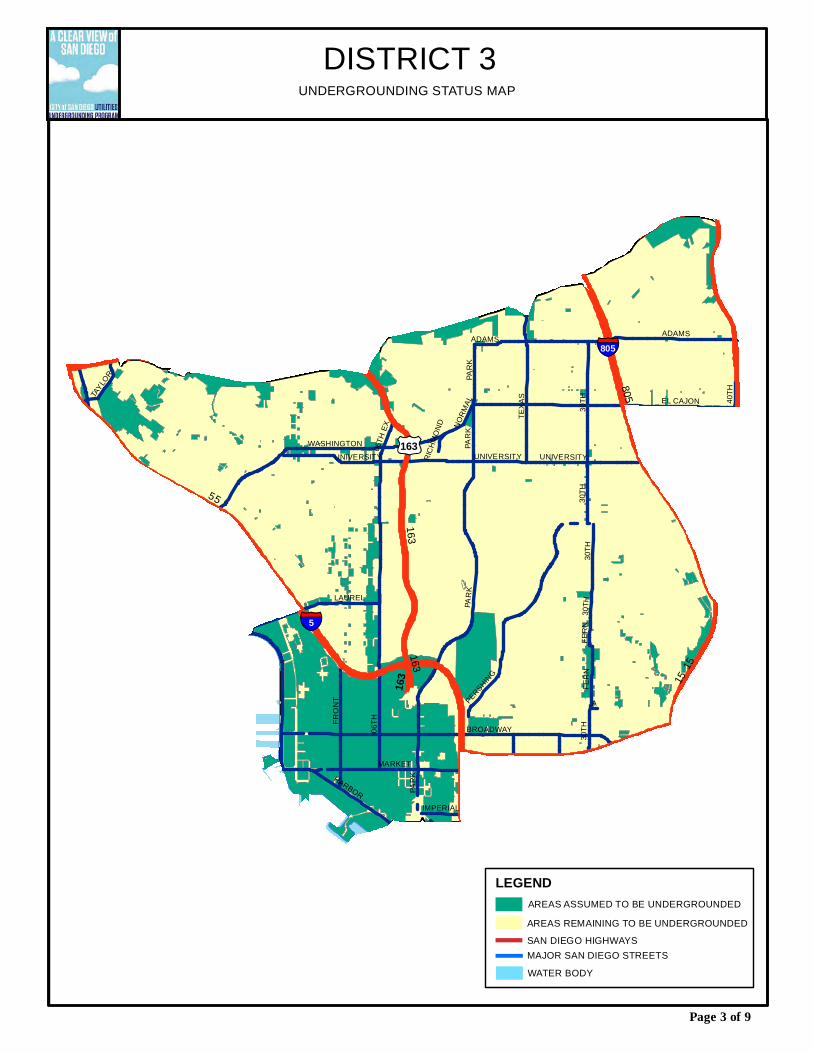
AREAS ASSUMED TO BE UNDERGROUNDED
§̈¦805
5
163
805
15
163
5
163
15
§̈¦5
06TH
PARK
MARKET
ADAMS
IMPERIAL
TEXA
S
BROADWAY
EL CAJON
30TH 40
TH
PERSHING
WASHINGTON
LAUREL
HARBOR
UNIVERSITY
FRON
T
FERN
A
06TH
EX
TAYLO
R
NORM
AL
RICHM
OND
PARK
30TH
PARK
FERN
UNIVERSITY
30TH
PARK
ADAMS
30TH
30TH
UNIVERSITY£¤163
DISTRICT 3
LEGEND
SAN DIEGO HIGHWAYSAREAS REMAINING TO BE UNDERGROUNDED
MAJOR SAN DIEGO STREETS
Page 3 of 9
UNDERGROUNDING STATUS MAP
WATER BODY
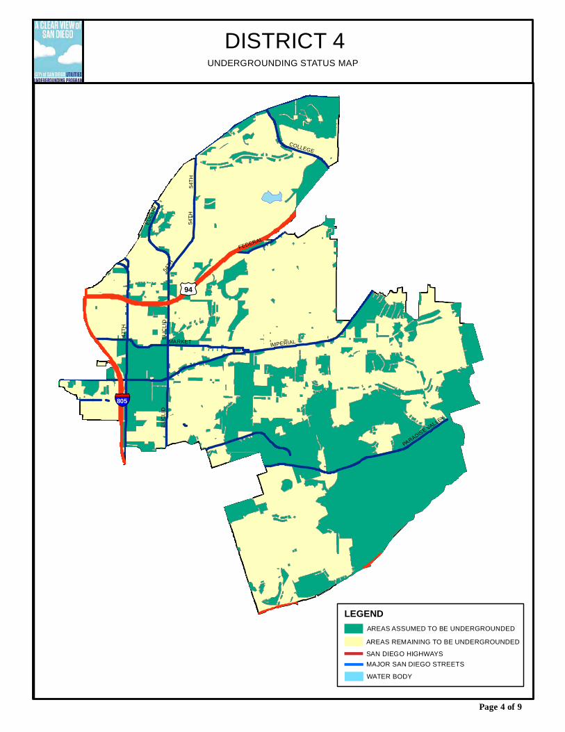
47TH
IMPERIAL
54TH
MARKET
PARADISE VALLEY
COLLEGEEU
CLID
EUCL
ID
FEDERAL
54TH
EUCL
ID
54TH
£¤94
§̈¦805
DISTRICT 4
Page 4 of 9
UNDERGROUNDING STATUS MAP
AREAS ASSUMED TO BE UNDERGROUNDEDLEGEND
SAN DIEGO HIGHWAYSAREAS REMAINING TO BE UNDERGROUNDED
MAJOR SAN DIEGO STREETSWATER BODY
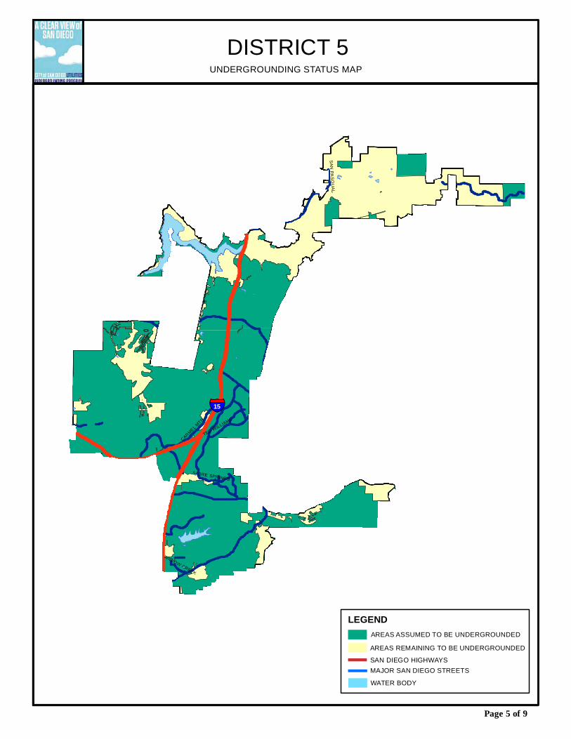
§̈¦15
CARMEL MTN
SAN PASQUAL
TED WILLIAMS
SABRE SPRINGS
WILLOW CREEK
DISTRICT 5
Page 5 of 9
UNDERGROUNDING STATUS MAP
AREAS ASSUMED TO BE UNDERGROUNDEDLEGEND
SAN DIEGO HIGHWAYSAREAS REMAINING TO BE UNDERGROUNDED
MAJOR SAN DIEGO STREETSWATER BODY
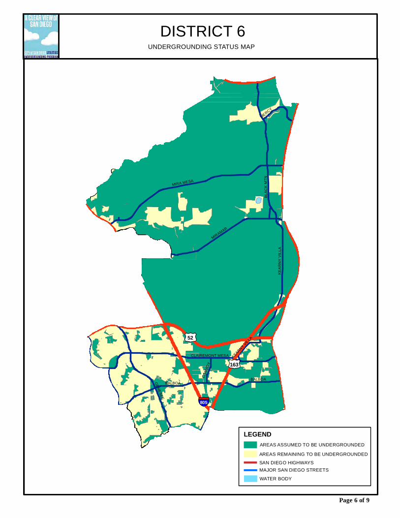
AREAS ASSUMED TO BE UNDERGROUNDED
§̈¦805
GENESEE
MIRA MESA
MIRAMAR
BLAC
K MT
N
KEAR
NY V
ILLA
CLAIREMONT MESA
BALBOA
MERCY
CONV
OY
BALBOA
KEARNY VILLA£¤52
£¤163
DISTRICT 6
LEGEND
SAN DIEGO HIGHWAYSAREAS REMAINING TO BE UNDERGROUNDED
MAJOR SAN DIEGO STREETS
Page 6 of 9
UNDERGROUNDING STATUS MAP
WATER BODY

AREAS ASSUMED TO BE UNDERGROUNDED
§̈¦805
§̈¦8
£¤163
§̈¦15
FRIARS
NAVAJO
MISS
ION G
ORGE
LINDA V
ISTA
WARING
SANT
O
CLAIREMONT MESA
JACKSONCOLLEGE
£¤52
DISTRICT 7
LEGEND
SAN DIEGO HIGHWAYSAREAS REMAINING TO BE UNDERGROUNDED
MAJOR SAN DIEGO STREETS
Page 7 of 9
UNDERGROUNDING STATUS MAP
WATER BODY
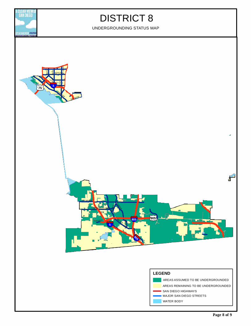
AREAS ASSUMED TO BE UNDERGROUNDED
§̈¦5§̈¦805
§̈¦5
§̈¦805
HARBOR
PALM (SB)
BEYER
32ND
28TH25TH
PICADORCORONADO (SB)
SMYT
HETOCAYO
BEYE
R
DIVISION
IMPERIAL
32ND
28TH
£¤905
£¤75
DISTRICT 8
LEGEND
SAN DIEGO HIGHWAYSAREAS REMAINING TO BE UNDERGROUNDED
MAJOR SAN DIEGO STREETS
Page 8 of 9
UNDERGROUNDING STATUS MAP
WATER BODY
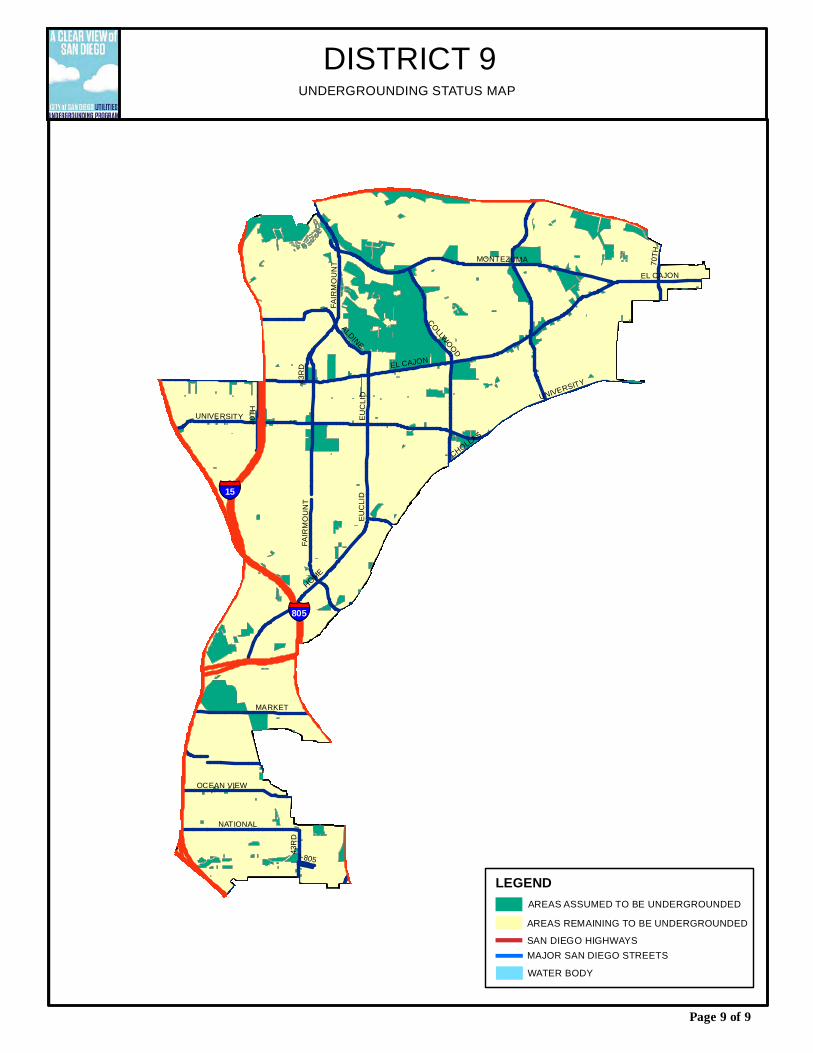
AREAS ASSUMED TO BE UNDERGROUNDED
§̈¦805
§̈¦15
HOME
EL CAJON
UNIVERSITY
MONTEZUMA40
TH
NATIONAL
OCEAN VIEW
ALDINE
COLLWOOD
FAIR
MOUN
T
CHOLLAS
I-805
43RD
43RD
EL CAJON
FAIR
MOUN
T
EUCL
ID
MARKET
70TH
EUCL
ID
UNIVERSITY
DISTRICT 9
LEGEND
SAN DIEGO HIGHWAYSAREAS REMAINING TO BE UNDERGROUNDED
MAJOR SAN DIEGO STREETS
Page 9 of 9
UNDERGROUNDING STATUS MAP
WATER BODY