validation and results of a scale model of dew deposition in urban environments
TRANSCRIPT

INTERNATIONAL JOURNAL OF CLIMATOLOGY
Int. J. Climatol. 22: 1915–1933 (2002)
Published online in Wiley InterScience (www.interscience.wiley.com). DOI: 10.1002/joc.856
VALIDATION AND RESULTS OF A SCALE MODEL OF DEW DEPOSITIONIN URBAN ENVIRONMENTS
K. RICHARDSa,* and T. R. OKEb
a Geography Department, University of Otago, Dunedin, New Zealandb Geography Department, University of British Columbia, Vancouver, BC, Canada
Received 2 July 2001Revised 6 August 2002
Accepted 6 August 2002
ABSTRACT
There is growing interest in urban dew and its significance in questions of urban climate and air pollution deposition,but little research has been undertaken to study it. In this study, a generic, urban residential neighbourhood is modelledout-of-doors at a scale of 0.125, using three wooden houses (1.08 m tall), a concrete pavement (1.0 m in width), agrassed park (7.5 m in half-width) and several small trees (up to 1.5 m tall). The thermal inertia of each house is inflated,according to the internal thermal mass (ITM) approach, so that nocturnal surface temperatures are conserved. First-ordervalidation was achieved through comparison with data collected at nearby full-scale sites in Vancouver, BC, Canada.Moisture accumulation (measured by blotting on grass and by lysimetry) is found to be primarily controlled by nocturnalweather conditions and the intrinsic nature of each substrate, e.g. dewfall is abundant on nights with few clouds and lightwinds, and on surfaces such as grass and asphalt–shingle roofs, which cool rapidly after sunset. However, these responsesare modified by location effects related to the net radiation balance of the surface, which itself is strongly linked to sitegeometry as expressed by sky view factor and whether surfaces are isolated from heat sources. The dominant mechanismis argued to be the systematic increase in longwave radiation loss that is associated with increased sky view. Resultsagree with those observed at the full scale and suggest that maps of sky view factor, and knowledge of dew at an opensite, can potentially be used to create maps of dew distribution in urban and other complex environments. Copyright 2002 Royal Meteorological Society.
KEY WORDS: Canada; dew; model; scaling; thermal scaling; urban climate; urban dew
1. INTRODUCTION
The presence of dew is linked to many topics in the natural and applied sciences. Moisture from dew has arole as a water source for plants and animals (Sharma, 1976), in the growth of fungal disease on crops (Huberand Gillespie, 1992), in harvesting practices (Newton and Riley, 1964), and there is potential for dew to becollected for human use, where other sources of fresh water are limited (Nikolayev et al., 1996).
In the case of cities, there is growing scientific interest in dew in relation to questions of urban humidity,evaporation rates, near-surface temperature, air pollution deposition and the subsequent chemical damageto plants and materials (Wisniewski, 1982; Okochi et al., 1998; Grimmond and Oke, 2000; Masson, 2000).Despite this, little research has been undertaken to describe and explain meso- and micro-scale patternsof urban dew, except work by Myers (1974), Mattsson (1979) and Richards (1999; Richards and Oke,2000). Studies of dew tend to focus on rural areas (e.g. Newton and Riley, 1964; Sharma, 1976; Sudmeyeret al., 1994); urban climate studies seldom address moisture fluxes beyond evaporation, and urban dew israrely measured.
* Correspondence to: K. Richards, Geography Department, University of Otago, P.O. Box 56, Dunedin, New Zealand;e-mail: [email protected]
Copyright 2002 Royal Meteorological Society
1916 K. RICHARDS AND T. R. OKE
Droplets of water that appear overnight on grass and other surfaces tend to be called ‘dew’, but it ismore rigorous to call this surface moisture because the source of the water may vary. Dew is strictlysurface water derived solely from condensation. It is commonly divided into dewfall, which is depositeddirectly from vapour in the lower atmosphere, and distillation, the recent origin of which is moist soil oradjacent wet leaves. Dewfall and distillation are similar in appearance, but they can be separated usinglysimetry (Slatyer and McIlroy, 1961) because the former is a net addition of water mass whereas thelatter is a redistribution between the soil and plant leaves in the lysimeter monolith. The amount andspatial distribution of dew is primarily governed by surface temperature because this reflects the surfaceenergy balance that governs deposition rates. Dew is most common on nights with clear skies and lightwinds, and when the lower atmosphere is moist (Garratt and Segal, 1988). Under such conditions, dewdeposition is enhanced because near-surface stability suppresses turbulent mixing and surface radiativecooling dominates the surface energy balance. Dew is a small mass flux: accumulation on leaves seldomexceeds 0.3–0.5 mm per night. However, this is not trivial in terms of the energy required to dry thesurface: at 10 °C, 1.24 MJ m−2 latent heat is required to evaporate 0.5 mm depth of water. On grass andcertain other plants, guttation may also be present, i.e. fluid exuded through leaf pores under internalpressure. This occurs when leaves are fully turgid, surface air is close to saturation, and the rate ofwater supply from the roots exceeds losses due to transpiration. The general consensus is that its rateis a function of soil moisture and temperature, but the linking mechanisms are uncertain. It typicallyforms large droplets on the tips of grass blades and its presence tends to coincide with dew (Hughes andBrimblecombe, 1994).
Processes of dew formation are the same in urban and rural areas, but in cities the surface on whichdew forms is often more complex: a three-dimensional mosaic of many, often dissimilar, materials. Incontrast, rural dew is typically measured on a relatively extensive, homogeneous surface, e.g. a pastureor crop canopy (Sharma, 1976; Sudmeyer et al., 1994). Scale modelling is consequently attractive in anurban study because it permits the urban landscape to be reduced in complexity and size, and allowsstructural elements (e.g. buildings and trees) to be more easily manipulated. Dew is difficult to createartificially. Few have attempted to do so and methods are crude, e.g. outdoor refrigeration, droplets in afog chamber, or water sprayed onto leaves (Mulawa et al., 1986; Arends and Eenkhoorn, 1989; Fuentes andGillespie, 1992). Though adequate for investigating the consequences of dew, such as spore germinationor droplet chemistry, these approaches provide little information about its formation. Hardware models tostudy dew deposition are rare and must operate out-of-doors where dew forms naturally (e.g. Mattsson,1979). Out-of-doors models to study physical processes in built systems are more common (e.g. Davisand Pearson, 1970; McPherson, 1980; McPherson et al., 1989; Wegner et al., 1988). None addresses dewformation, but some provide insight into the surface temperature fields that are closely linked to processes ofdew deposition.
Cities seem to offer few sites favourable for dewfall compared with the vegetation in the countryside.Buildings and pavements retain heat well into the night, and the urban core (‘downtown’) landscapeis associated with the urban heat island phenomenon. This is attributed in part to the large sensibleheat storage capacity of urban building materials (e.g. brick and steel), but also to anthropogenic heatsources, increased shortwave radiation gain, and reduced longwave radiation loss in cities compared withtheir rural surroundings (Oke, 1987). However, field evidence from Vancouver indicates that grass andother vegetation (Spronken-Smith, 1994; Richards, 1999; Richards and Oke, 2000), and roofs (Richards,1999; Richards and Oke, 2000) in urban residential (‘suburban’) areas can accumulate significant amountsof dew when weather and site conditions are favourable. Further, ‘suburban’ landscapes in Vancouverand many other North American cities possess a degree of regularity or repetitiveness (Schmid, 1988;Schmid et al., 1991), so they can be modelled to a first order using relatively few generic landscapeelements (e.g. houses, streets, parks) arranged in representative configurations. The focus of this studywas consequently urban residential, rather than ‘downtown’ landscapes. In theory, if hardware modellingcan assess dew patterns within a scaled and simplified landscape, then the results can potentially beextrapolated to larger areas of similar geometry. This paper presents the design, validation and results ofsuch a model.
Copyright 2002 Royal Meteorological Society Int. J. Climatol. 22: 1915–1933 (2002)

URBAN DEW DEPOSITION 1917
2. THE INTERNAL THERMAL MASS APPROACH TO SCALING
For a scale model to be useful and results to have general applicability, formal scaling criteria must beaddressed. In this study, thermal scaling is critical because, when moisture transfer is not limiting, ratesof dew deposition are driven largely by surface temperature. Dew forms when air flow is slight andturbulence minimal, so scaling criteria associated with turbulent flow are less important. Theory and fieldobservations show that, besides lawns and other vegetation, house roofs can be important sites for urban dewdeposition (Richards, 1999). It is therefore necessary to address protocols specifically for the thermal scalingof individual houses.
In the laboratory, where conditions are strictly controlled, similitude of thermal character for houses andother objects is achieved by using a strict geometric approach to scaling dimensions, applying well-known‘rules’ to scale thermal–dynamic processes, and operating the model in scaled time. A common outcomeis that, while ratios of temperature are conserved in the model, actual temperatures are distorted comparedwith those seen at the full scale (Parczewski and Renzi, 1963; Atkinson, 1981; Oke, 1981; Chapman, 1984;Imbabi, 1990; Kreith and Bohn, 1993). For a dew model that operates outdoors and in real time, it is desirableto conserve temperatures (not ratios). It is postulated that, given similar ambient conditions, the amount ofdew per unit area would then be duplicated. Most scale models possess the same proportions as their full-scale equivalents, so that height, width and wall thickness are universally scaled by a factor F (e.g. 0.125).However, a model house scaled in this manner would cool too fast and accumulate relatively more dew thana full-scale house if exposed out-of-doors overnight. This is because a smaller object has proportionately lessthermal inertia and a faster thermal response, compared with a larger object of similar shape and composition.Strict geometric scaling is thus inappropriate. A potentially viable solution, however, is to apply the internalthermal mass (ITM) approach to scale buildings in the model.
Aspects of ITM are evident in architecture and applied engineering, in the modelling of buildings andindoor climates (McPherson, 1980; McPherson et al., 1989; Mills, 1997). ITM consists of scaling overalldimensions of buildings geometrically, but controlling thermal behaviour by regulating the thermal mass cM
in the ‘wall’ of the model compared with that in its ‘interior’. Here, the wall includes the outer walls, roofand floor of a house; the interior is the inside walls, fittings and an air volume. To implement the approach,the walls in the model are constructed at full-scale thickness using the same materials as at the full scale,e.g. siding, framing, insulation and roofing. The thermal inertia of the otherwise empty interior of the modelis then inflated by adding a calculated mass, e.g. bottled water. To conserve the thermal response of the modelin real time, the ITM of the model is scaled by the ratio of scaled to full-scaled wall volume (McPherson,1980; McPherson et al., 1989)
cMim = cMihVwm
Vwh(1)
where cMi (J K−1) is the interior thermal mass, Vw (m3) is wall volume, and the subscripts ‘m’ and ‘h’ indicatemodel and full-scale house respectively. The amount of cMim required is a function of F , and building shape,which governs wall volume. However, for many single-family wooden houses in Vancouver and elsewhere,it is reasonable to assume that building form can be approximated by a cube with proportionately thin walls.In such cases, a simplification is possible because the ratio cMim:cMih then approaches F 2 (McPherson, 1980;McPherson et al., 1989; Richards, 1999). The error involved in scaling by F 2 is conservative: slightly morethermal inertia is added to the model than is strictly required. Thus the model would cool more slowly aftersunset and slightly underestimate dew accumulation, compared with its full-scale equivalent.
The theoretical outcome of partitioning and scaling the thermal mass of the building in this manner is thatthe model cools at the same rate as a similar full-scale building, and shows comparable surface temperaturesunder comparable ambient environmental conditions. It follows that it is theoretically possible to construct ascale model of a building for which surface temperature mimics that seen at the full scale. Thus, in theory,ITM will permit temperature–time-dependent processes, such as dew accumulation, to be duplicated.
Copyright 2002 Royal Meteorological Society Int. J. Climatol. 22: 1915–1933 (2002)

1918 K. RICHARDS AND T. R. OKE
3. METHODS
3.1. The hardware model
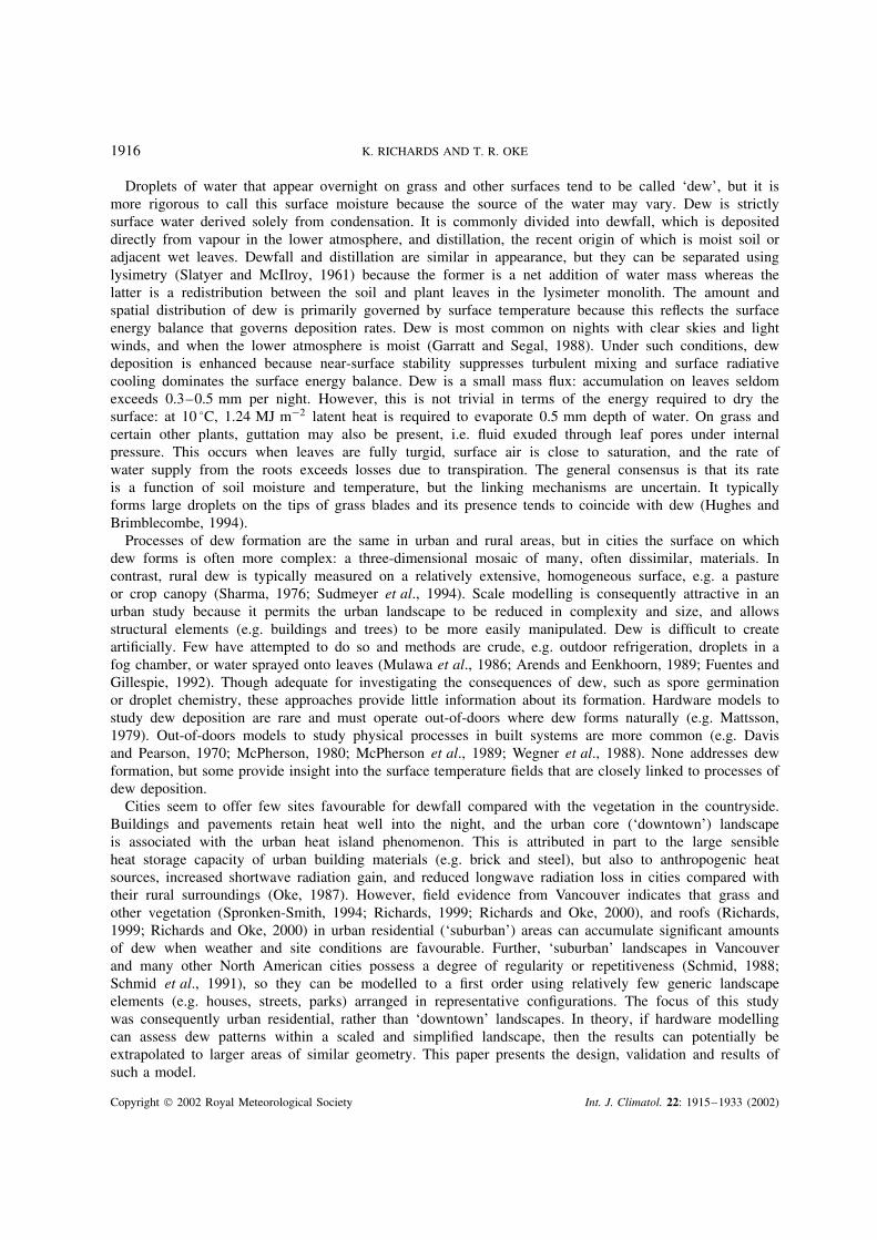
The hardware model was constructed out-of-doors at the University of British Columbia (UBC) campusin Vancouver, Canada (49°15′N, 123°18′W) at an open, grassed site with a sky view factor ψ of 0.98. Threegeneric, urban residential landscape units, scaled by 0.125, were represented. These were a row of houseswith grassed front yards, a paved street with trees, and an open, grassed park edged with trees (Figure 1).
Three similar wooden houses were constructed and placed along the north edge of a grassed plot (9 m×12 min width): two with their longest wall oriented east–west, parallel to street direction, and one normal to this.Two free-standing, plywood walls were installed in line with the row of houses; smaller panels attached tothese were angled forward by 40°. These false walls increased the effective ‘street’ length, in accord withscaling criteria (described below).
Each house was 1.08 m tall and 1.10 m × 0.76 m in width, with a steeply pitched (45°) roof covered withbrown asphalt shingles. Exterior walls were painted white; interior surfaces were lined with plastic as a vapourbarrier; and expanded-polystyrene board and sealed air-filled cavities were used to give insulation thicknessesof 0.09 m and 0.08 m for walls and floors respectively. An expanded-polystyrene board (0.05 m thick) atthe top of the walls defined an attic space in each house. 43.1 litres of water, in 4 litre plastic containers,were placed in the interior of each house. This provided 0.18 MJ K−1 of interior thermal mass cMim for eachmodel house and simulated the existence of otherwise absent internal free-standing walls and furnishings,the assumed thermal mass of which was scaled by 0.0156, according to the ITM approach. It was assumedthat cMih for a single-family dwelling was ∼12.8 MJ K−1 (McPherson et al., 1989). Roofs were removableto permit access to instruments, and attics were passively ventilated via openings in each gable, to preventthem overheating during daytime (McPherson, 1980). No attempt was made to simulate human occupancy orenergy use, and buildings were windowless.
Concrete paving slabs (0.08 m thick) were used to model a street pavement (1.0 m wide). This divided theturf in the model into two areas: a 2.5 m wide lawn in front of the row of houses, and an urban park (7.5 m
Figure 1. The 1 : 8 scale, out-of-doors model of a residential neighbourhood constructed and run at the UBC campus during the summerof 1996
Copyright 2002 Royal Meteorological Society Int. J. Climatol. 22: 1915–1933 (2002)

URBAN DEW DEPOSITION 1919
in half-width), extending from the pavement to the south boundary of the plot and beyond, because the shortgrass site extends for tens of metres. The theoretical park was symmetrical and elongated parallel to the streetdirection, so it was necessary to model only half its width; the half-width was chosen to be sufficient so thatthe trees that were in theory present at the far sides of the park could be ignored. That is, because they wouldhave had a negligible effect on view factors within the plot (Spronken-Smith and Oke, 1999).
When trees were present in the model, they consisted of a row of five Japanese maples (1.5 m tall) plantedat the south edge of the street pavement to model both street and park-edge trees, and five pyramidal cedars(1.2 m tall) planted between the houses to model yard trees.
The model was run during the summer of 1996, after a trial in 1994. During June–July, 1996, 20 nightswith a variety of weather conditions, but no rain, were selected for intensive study. Two configurations wereused: (a) with trees in the model to represent street/park-edge and yard trees (on year days (YD) 153–182)and (b) without trees but with the model configuration otherwise unchanged (YD 183–207). When the treeswere removed, their locations were filled and re-turfed. The plot was irrigated and mown at regular intervalsduring the summer.
3.2. Scaling considerations
Elements in the scale model were roughly equivalent to objects at the full scale in residential neighbourhoodsin Vancouver (Schmid, 1988; Voogt, 1995), scaled by 0.125. That is, the model houses were equivalent to8.6 m or 1.5–2.0 storeys in height, trees were equivalent to 10–12 m tall, model building lot width wasequivalent to 12 m, and the model park had a half-width equivalent to 60 m at the full scale. For practicalreasons, some dimensions were less realistic: houses were constructed using pre-cut timber designed to builddoghouses, and thus were proportionately narrow compared with real houses; lawn width was exaggerated bya factor of 1.5–2.0 to permit easy access for sampling; and the juvenile trees in the model conformed onlypartially to the morphology of full-grown trees. For convenience, expanded polystyrene and sealed air-filledcavities were substituted for the glass-fibre batts commonly used as insulation in homes in Vancouver. Thethree materials have fairly similar thermal conductivities, i.e. 0.029 W m−1 K−1, 0.026 W m−1 K−1 at 10 °Cand 0.037 W m−1 K−1 respectively (Oke, 1987; ASHRAE, 1993). In retrospect, the model floor (with 0.08 minsulation) and ceiling (0.05 m insulation) were probably under-insulated — 0.15 m of insulation would havebeen more realistic. Wood was used as the main building material for convenience, and because woodenhouses are commonplace in Vancouver and many cities. However, any real building material could have beensubstituted, e.g. bricks.
The thermal inertia of each model building was inflated according to ITM, so that, in theory, nocturnalsurface temperatures would be conserved in real time. Under ITM, the surface texture, albedo, emissivityand water absorptivity of built surfaces were automatically preserved because real building materials (wood,shingles, concrete) were used. ITM explicitly applies to buildings, not to vegetation. Nevertheless, in ananalogous approach, the texture and radiative properties of grassed surfaces were preserved because realgrass was used and lawn length was unscaled. The overall dimensions of trees were scaled geometrically inheight and canopy width, and using real maples and cedars conserved leaf characteristics.
The model consists of relatively few elements (buildings and trees), but simulates an extensive ‘suburban’neighbourhood. The sky view environment for an isolated object differs from that of a similar object embeddedin an extensive array (e.g. a ‘suburb’), and this has important implications for radiative cooling in the model.For shortwave radiation, for a canyon-like landscape (e.g. a city street) (Arnfield, 1976; Voogt and Oke,1991), scaling criteria prescribe that canyon length must equal the greater of 8H and 8W if the canyon is toact radiatively as if infinite in length (where H is the height and W is the width of the canyon). The relationis also presumed to hold for longwave radiation. The street in the scale model forms a canyon-like landscape,i.e. with house and tree ‘walls’, and a lawn ‘floor’. Radiative theory would thus dictate a minimum ‘street-canyon’ length in the model of 20 m, i.e. eight times the lawn width. However, in this study, stereographicplots of theoretical landscapes (Figure 2) were used to specify the shape and placement of false walls. Thatis, from the perspective of a central point on the lawn, similitude was achieved in less than half this lengthby incorporating false perspective (i.e. inwardly angled panels) and by ignoring far distant objects, because
Copyright 2002 Royal Meteorological Society Int. J. Climatol. 22: 1915–1933 (2002)

1920 K. RICHARDS AND T. R. OKE
Figure 2. Stereographic depiction of the theoretical geometry looking up at the sky zenith from a point at the centre of the urban lawn:‘1’ is the extent of a street of infinite length, ‘2’ is the minimum street length (i.e. eight times the lawn width) dictated by radiative
theory, and ‘3’ is the street length simulated in the hardware model using false perspective
they contribute little to ψ at the centre of the model. In the final decision, radiative similitude for the centreof the lawn was achieved with an 8.5 m length model (labelled ‘3’ in Figure 2). The view factor environmentfor the model park was less accurately conserved, because the row of trees was short in length, relative topark width. However, the associated error was small: ψ increased only slightly more rapidly along the centraltransect in the park, compared with the ideal case of a semi-infinite row of park-edge trees, and the valuesfor the open park were the same.
It was assumed that the model was sufficiently large in horizontal extent to produce a local microclimatesimilar to that seen in a real neighbourhood, in weather conditions when dew forms, i.e. when turbulenceand advection are weak, and longwave radiation and conduction are the dominant processes of heattransfer from the surface. It was also assumed that vertical gradients of air temperature, humidity andwind at night were less important than surface controls on moisture accumulation. Near the groundthe microclimate varies with elevation and, whereas the model height is scaled by length, the loweratmosphere in which it is immersed is not scaled. Thus, for example, the roof of a scale model houseis likely to be exposed to a different wind speed than the roof of a full-scale building sited at thesame location. However, vertical gradients in the urban and plant canopy layers tend to be smallerthan those typical of the open countryside (Nakamura and Oke, 1988; Kaimal and Finnigan, 1994),and this will tend to mitigate potential errors related to height of exposure of scaled objects in anunscaled atmosphere.
Copyright 2002 Royal Meteorological Society Int. J. Climatol. 22: 1915–1933 (2002)

URBAN DEW DEPOSITION 1921
3.3. Data collection
Spatial variation in the model was focused in a plane at right angles to ‘along-street’ direction. This meantthat measurement in the model could be simplified to a central transect at right angles to street direction(Figure 3). Surface temperature was measured using thermocouples attached to built surfaces and leaves, anddownward-facing infrared thermometers (IRTs; Everest Interscience, Model 4000A, 15° instantaneous field ofview (FOV)) mounted over grass surfaces. Wetness sensors (following the design of Weiss and Lukens (1981))were used to monitor the duration of wetness on surfaces in the model. Dewfall (i.e. that proportion of dewderived directly from the lower atmosphere) was measured using five electronic, weighing mini-lysimeters(Grimmond et al., 1992): two installed in grassed surfaces in the model lawn and park, one under a pottedmaple (1.3 m tall), one under a section of concrete pavement, and another installed in the 45° south-facingroof facet of the central house, under a rectangular panel of roofing. Mass changes were converted to dewfallamounts using plan surface area, i.e. 0.11 m2 for the ‘lawn’, ‘park’ and ‘roof’ mini-lysimeters. Values wereexpressed as equivalent depths of water, with a measurement error of ±0.01 mm, which is equivalent to alatent heat flux QE of ∼7 W m−2. Electronic instruments were sampled every 60 s and data were stored as15-min averages, except for wetness sensor data, which were instantaneous samples at 15 minute intervals.
Manual surveys were also conducted at dawn on selected days. On these occasions the surface temperaturewas measured using a hand-held IRT (Omega OS43, 60° FOV) held 0.1 m above the surface; this instrumenthad an accuracy of ±0.5 °C. The amount of surface moisture on grass (i.e. dew + guttation, when present) wassampled at 0.30 m intervals along the central transect, using pads of blotting paper (0.2 m×0.1 m in width).The change in mass of these pads yielded the amount of water absorbed from the wet grass, with an uncertaintyof ±0.01 mm. However, blotting does not provide absolute amounts of water accumulation, because somedroplets inevitably escape capture. Thus, an unknown fraction of surface wetness is unmeasured. However,errors for blotting on grass are normally assumed to be systematic and, thus, spatial trends are conserved(Monteith, 1957; Collins, 1961; Sudmeyer et al., 1994).
Ambient air temperature, humidity and wind speed were measured at 1.5 m at the southeast corner of themodelling site. Two local Atmosphere and Environment Service of Canada climate stations, UBC (250 mto the south of the model) and Vancouver International Airport (9 km to the southeast), provided additionalenvironmental data, which were used to describe weather conditions.
1 m
22 3
11 2
2
23
33 (wall)
3 (wall)
2,3 (r oof)
2,3 (r oof)
32,3
1
1 3
Mini-lysimeterWetness sensorThermocoupleAmbient conditionsTransect
1234
4
4
12
22 3
11
1
22
23
3
3
3 (wall)
3 (wall)
2,3 (roof)
2,3 (roof)
32,3
1
LawnHouses
Street
Park
1 m
2.5 m
1 m
0.5 m
7.5 m
9 m
Figure 3. Schematic of the scale model showing instrumentation and the central measurement transect (dashed line) that runs from thenorth (houses) to the south (open park) side of the site
Copyright 2002 Royal Meteorological Society Int. J. Climatol. 22: 1915–1933 (2002)

1922 K. RICHARDS AND T. R. OKE
3.4. Derived parameters
For convenience, nocturnal weather conditions were summarized using a pre-existing empirical factor(Oke, 1998)
�w = (1 − kn2)(u−0.5) (2)
where n and u are weighted mean cloud cover (tenths) and wind speed (m s−1 at 10 m elevation, at an opensite) respectively, and k is 0.88, 0.73 and 0.24 for low, middle and high cloud respectively. �w combines theeffectiveness of cloud in reducing net longwave radiation loss from the surface and the non-linear effect ofturbulence in homogenizing temperature structures at the surface. It identifies weather conditions that favourradiative cooling and, thus, urban heat island development (Oke, 1998). Richards (1999), using data for 42summer days, showed a general and positive association between �w and the amount of surface moisturemeasured by blotting on grass at open sites at dawn: for �w ≥1.0 (a cloudless night with wind speeds≤1 m s−1), dew accumulation tended to be favoured; as �w approached zero the presence of nocturnal cloudand/or wind made dew unlikely. The scheme applies to dew deposition only when humidity is not limiting,but air in Vancouver is relatively moist under most weather conditions (Oke and Hay, 1994; Richards, 1999).On grass, moisture due to guttation may be present on any particular night, but it is not predicted by �w.
Sky view in the model was derived using fish-eye lens photography and site geometry. At several sites inthe model, a fish-eye lens photograph was taken at ground level looking up at the sky zenith. The resultingimage was projected onto a stereographic grid. Distributions of sky and terrain were then converted to polarcoordinates, from which ψ was computed (Steyn, 1980; Steyn and Lyons, 1985). Site geometry and radiationconfiguration formulae were used to determine further ψ values across the model (Howell, 1982; Spronken-Smith and Oke, 1999). A theoretical wall of apparent roof height approximated the horizon obstruction createdby the row of model houses, and elevated spheres were used to approximate the maple trees. Fish-eye lensphotographs taken prior to the installation of the model showed that the modelling site itself had a terrainview factor of 0.02, i.e. due to surrounding distant trees and buildings. This set an upper limit of 0.98 forcalculated ψ values for open locations in the model. Consequently, values for the model park (and lawn,when the trees were absent) were adjusted downwards (by a maximum of 0.02) to account for the slighthorizon obstruction due to the surrounding landscape.
Surface moisture S data were normalized by ψ to facilitate a quantitative analysis of agreement betweenthe two measures, i.e. using (Richards, 1999)
S =(
Sx − Sn
ψx − ψn
)(ψ − ψn) (3)
where S and S have units of millimetres per night, and subscripts ‘x’ and ‘n’ indicate maximum and minimumvalues respectively. In this study, Sn was set to zero, and Sx was a weighted mean for the open model park.Data were compared using means (S, S), mean absolute error (ME), and root mean square error (RMSE), andagreement between the sets was described using (Willmott, 1984)
D = 1 − n(RMSE)2
∑ (|S − S| + |S − S|
)2 (4)
where D = 0 means no agreement, and D = 1.0 means perfect agreement. D describes correlation in the databetter than other measures, such as Pearson’s coefficient of determination r2, which is insensitive to additiveand proportional differences between datasets (Willmott, 1984).
Copyright 2002 Royal Meteorological Society Int. J. Climatol. 22: 1915–1933 (2002)

URBAN DEW DEPOSITION 1923
4. MODEL VALIDATION
4.1. Validation sites and data collection
The behaviour of the model was validated to a first approximation through comparison of synchronousdata collected on the model, a full-scale service building located 200 m south of the model, and a full-scaleresidential lot in the ‘suburban’ neighbourhood of Kerrisdale, 8 km to the west of the model.
Both the service building and the house at the residential lot have a simple form, comparable to that ofthe scaled houses. The one-storey (5.0 m tall) service building is wooden with a black asphalt–shingle roof(pitch: 45°) and the roof ridge is orientated north–south. Although it is connected to an equipment barn by awide, roofed passageway, it is essentially free standing and at a reasonably open site. The 1.5-storey (6.8 mtall) residential house is of stucco-and-wood construction, with a brown asphalt–shingle roof (pitch: 35°)and the roof ridge is orientated east–west, parallel to the street direction. Vegetation is abundant at this site,including street and yard trees.
An equivalent set of synchronous data was not available in 1996 for an urban park location. However,surface moisture data were collected at open, grassed locations in Vancouver during 1993, i.e. on a small(0.6 ha) ‘suburban’ park (Everett Park) bordered by deciduous trees and on a lawn in an urban residentiallot. These sites are respectively located 1 km and 3 km west of the model site. At these sites the amountof surface moisture on grass at dawn was measured by blotting on 38 summer days. These data allowed aqualitative comparison to be made between patterns of moisture accumulation on model and full-scale parkand lawn surfaces.
General similarity existed in the structural details of individual scaled and full-scale landscape elements,but physical correspondence is not exact, e.g. roof pitch and colour, and shading patterns differed betweensites. Such differences have important implications for the temperature and radiation balances of surfaces byday and, thus, surface temperatures after sunset. Therefore exact, one-to-one similitude is not to be expectedbetween the model and full-scale sites. Rather, comparisons are undertaken to assess whether surfaces in themodel behave qualitatively and quantitatively in a ‘realistic’ manner.
4.2. Data collection
Measurement methods at full-scale sites followed those employed in the model, but surfaces at the full-scalesites were less intensively instrumented, and not all methods were used everywhere. The instrumentation andmethods that were employed duplicated those used in the model, with a few exceptions. At the residentiallot, ambient conditions (air temperature, humidity and wind speed) were monitored at mid-roof level (5.3 mabove ground); thermocouples were attached to roof surfaces; an IRT was mounted over the backyard lawn;surveys of surface temperature were undertaken at dawn using a hand-held IRT (Minolta Cyclops, 1.7° FOV);wetness sensors and blotting were used to monitor surface moisture on roof and lawn surfaces; and dewfallwas measured using electronic mini-lysimeters — one in the backyard lawn, and one at 7.0 m above groundon the roof of the dwelling, enclosed in a purpose-built, false roof (1.2 m × 1.2 m in width) with a flat uppersurface. At the service building, thermocouples and wetness sensors were installed on roof and wall surfaces,and ambient conditions were monitored at 3.6 m (i.e. mid-roof level) on a climate mast, located 70 m to thesouthwest of the service building. Only blotting of surface moisture at dawn was undertaken at the park andlawn sites investigated in 1993.
4.3. Model: full-scale comparisons
Geometric similarity is examined by comparing fish-eye lens photographs, and the sky view factors derivedfrom them. Reasonable agreement exists between values for the most open site in the model and full-scale parks(ψ = 0.98 and 0.93 respectively), and the model and full-scale street-with-trees environments (ψ = 0.82 and0.72 respectively). Even the extent of horizon obstruction due to a single house or tree is similar. Agreementis less close for the most open location on the model lawn (ψ = 0.92, with trees present) and full-scale lawns
Copyright 2002 Royal Meteorological Society Int. J. Climatol. 22: 1915–1933 (2002)

1924 K. RICHARDS AND T. R. OKE
Table I. Summary of weather conditions in Vancouver for four nights during the summer of 1996
YD Wind conditions at 10 ma Cloud conditionsb �wa,b Surface moisturec (mm)
Speed (m s−1) Direction Cover Height
171–172 1.0 NE 0.0 — 1.00 0.08173–174 3.5 E 0.2 mid 0.51 0.01187–188 1.5 NE 0.0 — 0.82 0.08191–192 2.0 E 0.8 low 0.31 0.03
a Data source: UBC climate station.b Data source: Vancouver International Airport.c Data source: The model park.
Table II. Summary of statistical indices used to test the similarity between ambient and surface conditions at the modeland full-scale sites. Data are 15 min mean values for four nights in 1996 and instantaneous samples made at dawn, andmeans and (in parentheses) standard deviations for these sets. The number of nights sampled n = 4, unless otherwise
indicated
Scale model Full-scale service building Full-scale residential lot
15 minute dataMeasurement height (m) 1.5 3.6 1.5 5.3Air temperature ( °C) 14.0 (1.5) 14.1 (1.6) 13.2 (1.9) 13.9 (1.8)Vapour density (g m−3) 9.2 (0.6) 9.3 (0.6) 9.0 (0.6) 9.1 (0.7)Wind speed (m s−1) 1.0 (0.7) 1.6 (1.1) — 0.8 (0.7)
Surface temperatures ( °C)Roof facets 10.1 (2.2) 10.7 (2.8) —Grass 10.3 (1.7)a — 10.9 (2.0)Walls 11.4 (1.9) 14.3 (2.1) 12.0 (2.3)b
Daily dataSurface moisture (mm per night)
Grass (n = 18) 0.05 (0.03) — 0.03 (0.03)Dewfall (mm per night)
Grass (n = 14) 0.05 (0.04) — 0.07 (0.05)Roof (n = 15) 0.10 (0.06) — 0.13 (0.04)
a For grass on the model lawn (values for the model park are 10.0 and 2.0 respectively).b Instantaneous samples at dawn for 16 nights (for this set, the equivalent values for walls in the model are 10.7 and 2.5 respectively).
studied in 1993 (ψ = 0.55) and 1996 (ψ = 0.66), but this is to be expected because the width and, therefore,sky view of the model lawn are deliberately exaggerated.
Ambient air temperature, humidity and wind speed conditions at relative roof-level at the model and full-scale sites are compared using synchronous, 15 min interval data for two nights in 1996 with conditionsfavourable (YD 171/2 and 187/8), and two unfavourable (YD 173/4 and 191/2) for dew accumulation (seeTable I). Data from foot-surveys of surface temperature and moisture are also examined. Air temperatureand water vapour density values at each site are similar (≤0.8 °C and ≤0.2 g m−3 difference respectively)(Table II). Differences are unsystematic, and strong central tendencies are evident for equivalent sets. Atnight, when nocturnal winds are light, mean wind speeds at roof level are similar at all locations. But athigher wind speeds the 15 min mean values at 1.5 m height in the model are only about 0.67 times thoseobserved at the 3.6 m height at the service building, and about 3.3 times those observed at the residential lotat 5.3 m. The differences are explicable in terms of differences in measurement height between the modeland full-scale cases at UBC, and the existence of a suburban canopy layer at the Kerrisdale site. The site
Copyright 2002 Royal Meteorological Society Int. J. Climatol. 22: 1915–1933 (2002)

URBAN DEW DEPOSITION 1925
of the model at UBC is relatively open and smooth, whereas the residential lot is embedded in an extensiveurban area. When winds are strong, dew accumulation is not favoured, so these inter-site differences becomeless important.
There is reasonable agreement between the model and full-scale surface temperatures at night (Table II). Inparticular, there is good agreement between the 15 min values for roof facets (≤0.6 °C difference; Figure 4).Walls are consistently cooler in the model, but the differences are fairly small (typically ≤3.0 °C); and grassin the model tended to be cooler than the lawn at the real house by about 0.6 °C, probably due to the lowerψ and urban heat island effect. The model pavement is considerably cooler than the full-scale pavement atdawn (mean difference 3.5 °C). However, the difference is not critical, because neither cool sufficiently toaccumulate dew. At dawn, tree canopies in the model appear to be slightly warmer than those at the full-scalesite (mean difference 0.7 °C). There is no evidence to suggest that sensible heat fluxes of anthropogenic origingreatly affect roof temperature at dawn for the full-scale home.
Figure 4. Agreement between roof surface temperatures (°C) measured on the model and full-scale buildings for four nights in 1996.Data are synchronous, 15 min mean values measured by thermocouples on north- and south-facing (upper charts) roof facets at the
model and residential lot, and west- and east-facing (lower charts) facets at the model and service building
Copyright 2002 Royal Meteorological Society Int. J. Climatol. 22: 1915–1933 (2002)

1926 K. RICHARDS AND T. R. OKE
As noted earlier, the physical correspondence between the model and full-scale sites is not exact, i.e. dueto differences in albedo, aspect, slope, and thus shortwave radiation loading during the day. The physicalsettings also differed. Roof and wall temperatures are influenced by the exact layout of adjacent structures(trees, fences, eaves and other buildings) because they affect shading patterns (see Figure 1) and view factors.Hence, some residual heating differences are evident, e.g. roof surface temperatures (Figure 4) are the leastsimilar in the 1.5–2.5 h after sunset.
There is general agreement between patterns of moisture accumulation on the model and full-scale surfaces(Table II). The model roof accumulates similar or slightly less dewfall than that of the house, and grass inthe model tends to accumulate smaller amounts of dewfall, but more surface moisture, than the lawn at thereal house. Spatial patterns of surface moisture on grass (measured at dawn by blotting) in the scale model(Figure 5) bear strong qualitative resemblance to those seen at full-scale parks and lots — i.e. more dew isseen at open sites and at locations away from trees and buildings.
The model does not duplicate any one location or ensemble of sites. The relative similarity is thereforeencouraging. Absolute differences are small for most measures, and those evident are explicable in terms ofreal physical differences between the sites. Hence, it is concluded that the surface conditions in the scalemodel were ‘realistic’ and, therefore, the model could be used to gain insight into the patterns and relativemagnitudes of surface moisture and dewfall in urban environments.
Figure 5. Spatial trends of surface moisture accumulation on grass measured by blotting at dawn, for summer nights in Vancouver withclear skies and light winds. Data are for (a) a full-scale residential lawn (YD 240, 1993), (b) a full-scale, grassed park (YD 218, 1993)and (c) the scaled park in the hardware model (YD 172, 1996). In each case, a border of trees is located to the left-hand end of the
transect and a relatively open area to the right-hand end of the transect. The uncertainty in the data is ±0.01 mm
Copyright 2002 Royal Meteorological Society Int. J. Climatol. 22: 1915–1933 (2002)

URBAN DEW DEPOSITION 1927
5. SURFACE MOISTURE AND DEWFALL RESULTS AND DISCUSSION
Here, we present surface conditions at dawn for four nights with contrasting weather conditions (favourableand less favourable for dew) and site character (with and without trees). Individual nights are used, ratherthan averaged data, because weather is not strictly replicated, and events are part of a continuum.
5.1. Surface moisture on grass at dawn
At dawn, on nights when dew forms, the grass canopy in the model tends to be colder and to accumulategreater surface moisture at sites with a high sky view factor ψ , i.e. in the model park (ψ = 0.98) and (whentrees were present) at the relatively open centre of the model lawn (ψ = 0.92). Surface temperature is typicallyhigher, and moisture accumulation less where ψ is smaller, i.e. adjacent to the house wall (ψ ∼ 0.50) andunder the trees (ψ = 0.70). On YD 172, nocturnal weather conditions were characterized by light winds (i.e.u ∼ 1.0 m s−1), clear skies (n = 0.0) and a �w value of 1.00. At dawn, up to 0.11 mm of surface moisturewas measured on the model park, the temperature of which was 5.7 °C, and up to 0.07 mm on the model lawn,where grass temperatures were 6.5 °C (Figure 6). However, under the trees and close to the model building,where the grass canopy temperature was 9.7 °C, only 0.02–0.03 mm of surface moisture accumulated.
When trees are absent, site geometry is simpler and the temperature and moisture distributions reflect this(Figure 7). At dawn on YD 188, a night which also had weather that was favourable to dew accumulation(i.e. u ∼ 1.5 m s−1, n = 0.0 and �w = 0.82), 0.01 mm was sensed close to the model building, where thegrass temperature was 9.5 °C. Moisture increased, and temperature decreased rapidly with distance across the
Figure 6. Conditions at dawn on YD 172, 1996, with trees in the model (at a distance of 4 m distance from the front wall of the houses).Data are: (a) apparent grass canopy temperature sensed using an IRT (black circles); (b) surface moisture, with units of millimetres pernight, measured by blotting (black triangles), and sky view derived from site geometry (dashed line) and fish-eye lens photographs (greycircles). As indicated by the schematic cross-section, the model houses are to the left, the open park is to the right, and the discontinuityis the location of the model pavement. The uncertainties in the temperature and moisture data are ±0.5 °C and ±0.01 mm, respectively
Copyright 2002 Royal Meteorological Society Int. J. Climatol. 22: 1915–1933 (2002)

1928 K. RICHARDS AND T. R. OKE
Figure 7. Conditions at dawn in the model on YD 188, 1996, with the trees absent: (a) and (b) as for Figure 6 but with the trees in themodel removed
model lawn in agreement with the pattern of ψ . Up to 0.13 mm of surface moisture accumulated on grassin the model park, where the grassed surface was relatively cool (6.0 °C). The underlying mechanism forthese patterns is interpreted to be the systematic increase in longwave radiation loss that occurs when less ofthe sky heat sink is obscured by relatively warm objects (trees and buildings). Hence, surface temperature islower, and dew accumulation greater, when sky view is less restricted.
Similar spatial patterns of surface moisture that are relatable to those of ψ are evident in all weatherconditions when dew forms. They are most pronounced on nights with weather that strongly favours dewformation, i.e. when longwave radiative cooling can be inferred to be the dominant mechanism of surfaceheat loss. When �w was small, due to windy and/or cloudy conditions, dew accumulation was small acrossthe model and patterns were muted (Figure 8), e.g. on YD 174 (with u = 3.5 m s−1, n = 0.2 and �w = 0.51)and YD 192 (u = 2.0 m s−1, n = 0.8, �w = 0.31).
When the trees are not present in the model configuration, zones of increased temperature are often observedadjacent to the pavement (e.g. Figure 7). These features were absent during surveys undertaken prior to theinstallation of the model, and are not explained by the variation of ψ . Their presence or absence were maskedfor much of the modelling programme because their potential location coincided with the higher surfacetemperatures reasonably expected under trees. They are interpreted to be a pavement effect, created by thelateral transfer of sensible heat by conduction, or perhaps advection, from the relatively warm pavement toits surroundings. For grass at the edge of the park, it cannot be ruled out that there may have been a residualeffect on soil moisture from previously having trees in this part of the model. This may have had an effecton the ability of the soil to store heat, and its ability to supply water to the grass canopy as distillationor guttation. On several occasions, such as YD 188, the amount of surface moisture sensed on grass nearthe model pavement was also larger than might be expected given site geometry. The presence of guttationmay help to explain this pattern. Visual observations suggested that guttation was present in the model on
Copyright 2002 Royal Meteorological Society Int. J. Climatol. 22: 1915–1933 (2002)

URBAN DEW DEPOSITION 1929
Figure 8. Surface moisture data as for Figure 6 but for (a) YD 174 and (b) YD 192 with weather conditions less favourable for dew
many nights with dew. Guttation droplets seemed to be fairly evenly distributed across the model — exceptclose to the model pavement, where a relative excess was sometimes noted. When trees were present, itcould be argued that this extra guttation was related to an excess of soil moisture linked to tree shade, butthe feature was also seen when the trees were absent. Its coincidence with the warm anomaly describedabove suggests a common mechanism, such as greater plant water movement when the root zone is warmerand moister.
The spatial association between surface moisture accumulation and sky view factor is evident to the eyewhen Figures 6 and 7 are compared. Statistical tests of the agreement between S and the view factornormalized value S suggest that surface moisture in the model is well described by S, provided theaccumulation is large. For example, on YD 172 with up to 0.12 mm accumulation, there is close agreementbetween the means for S (0.06 mm) and S (0.07 mm), differences across the model are small (ME = 0.01mm; RMSE = 0.02 mm), and agreement between the sets is relatively strong (D = 0.87). Similarly, on YD188 with no trees in the model, the mean for both sets is 0.08 mm, ME = 0.02 mm, RMSE = 0.02 mm, andD = 0.85. On days with little surface moisture, all data and statistical indicators have small, and thereforesimilar, values but there is no real agreement between sets. For example, on YD 174 (with S = 0.01 mm)D = 0.36, and on YD 192 (with S = 0.03), D = 0.67.
Copyright 2002 Royal Meteorological Society Int. J. Climatol. 22: 1915–1933 (2002)

1930 K. RICHARDS AND T. R. OKE
A form of periodicity appears to be present in some of the data: moisture accumulation varies by up to0.05 mm over short distances (∼1 m) in the open park. However, a strong central tendency is present, andstandard deviations for such data are only ∼0.01–0.02 mm per night, for sites with ψ > 0.95. Patterns areindependent of the exact method of blotting employed. This feature is also seen at full-scale locations andmay be related to the heterogeneity of grass canopies.
5.2. Dewfall on the model
The amount of dewfall (i.e. condensation solely from the lower atmosphere) on the model at dawn(Figure 9), as sensed using mini-lysimeters, seems to be strongly governed by regional weather conditionsand the temporal patterns in the model show a strong similarity to patterns seen at the full scale for both roofand grass surfaces.
The removal of trees from the model on YD 182 is associated with a dramatic change in dewfallaccumulation on the model lawn. When trees are present (Figure 9(a)), no dewfall occurs, but when thetrees are removed (Figure 9(b)), dewfall is sensed on all nights. It is difficult to rule out the effects of weatherdifferences between the two treatment periods — by chance, the changeover in model set-up coincided witha shift to more favourable weather for dewfall, with higher humidity and less cloud. However, this patternof dewfall is interpreted to be largely due to view factor effects on radiative cooling and, perhaps, sheltereffects on vapour transport. By contrast, the change in site configuration had little apparent effect on dewfallfor the model roof and park. Trees provide only a small part of the horizon obstruction for these locations,so changes in ψ are small. This outcome also suggests that the aerodynamic effects of trees on moisturedelivery to these two particular surfaces are weak.
The model roof is a preferred site for dewfall accumulation. Dewfall was sensed by the ‘roof’ mini-lysimeteron 81% (13 out of 16) of the nights studied, whereas dewfall was sensed on the model park on only 67% ofnights. The amount deposited on the model roof almost always exceeds that sensed on the park; and valuesfor mean (0.09 mm per night) and maximum (0.18 mm per night) accumulation are twice as large for theroof as they are for the park.
For sites in the model with reasonably high ψ , where the influence of horizon obstructions on radiativecooling is reduced, grass and roof surfaces at dawn are ∼3.5–5.5 °C below the air temperature measuredat 1.5 m height, and maple leaves and pavement are ∼1.5–2.5 °C below air temperature (where the greater
0.00
0.10
0.20
0.30
146
a)
b)
150 151 155 159 164 165 172 173 174
0.00
0.10
0.20
0.30
187 188 189 190 191 192 193 194 195 196
Dew
fall
(mm
)
Roof Lawn Open Park
Figure 9. Maximum dewfall accumulation on the model measured at dawn using electronic, weighing mini-lysimeters installed in anasphalt–shingle roof and the model lawn and park: (a) with trees in the model (YD 146–YD 174) and (b) with the trees removed(YD 187–YD 196), where no bar means zero dewfall, and the uncertainty in the data is ±0.01 mm. NB: the sequence of days is
discontinuous
Copyright 2002 Royal Meteorological Society Int. J. Climatol. 22: 1915–1933 (2002)

URBAN DEW DEPOSITION 1931
values are for nights with heavy dew). It is reasonable, therefore, that the roof and the grass canopy in theopen park, which both have a relatively small heat storage capacity and are physically separated from potentialsources of sensible heat, are relatively cool and accumulate significant amounts of dewfall. On the other hand,no dewfall was sensed by the pavement mini-lysimeter, even when the horizon obstruction of the trees wasremoved. This is a surface with a larger heat storage capacity, which is in direct contact with the ground,and consequently remains relatively warm during the night. No dewfall is evident on the maple trees in themodel. The Japanese maple has deeply divided and relatively small (typically 0.06 m in diameter) leaves, soit is reasonable to assume they remain closely coupled to air temperature. Air movement at canopy level atthis site appeared to be sufficiently consistent throughout the night to inhibit dew accumulation. There is alsono evidence of dewfall (i.e. wetness) on the house walls. Walls have negligible ψ and are also in contactwith the residual heat reserves of the building through the night.
6. CONCLUSION
In environments with complex physical configuration, such as cities, modelling can be a viable alternativeto measurement. The hardware model described here demonstrates that in environments possessing complexgeometry, such as a three-dimensional urban model, spatial patterns are similarly complex. This is due, inpart, to juxtaposition of elements (trees, buildings, grass and concrete paving) and, for surface moisture ongrass, the potential effect of guttation.
In this study, the urban environment is reduced to a set of simple generic elements (houses, trees, grass,paving) arranged in a typical configuration so that dew deposition on representative units (lots, street, park)can be investigated. In theory, accumulation by individual landscape elements could later be amalgamated togive an areal estimate of the total amount of surface water present in a more specific urban area. However,the results of this exploratory study are not directly transferable to the full scale because urban residentiallandscapes are not truly repetitive at the scale of a lot or street; the effect of variations in site location, geometryand building materials is unknown; and uncertainty remains regarding the effects of height of exposure.
The presence and amount of surface moisture and dewfall in the model are found to be primarily controlledby weather and the nature of the substrate and are further modulated by effects relating to the net radiationbalance of the surface (especially site geometry, as expressed by ψ) and whether surfaces are in contact withheat sources. When weather conditions are favourable, significant amounts of dewfall are deposited on grassat open sites in the model and on asphalt–shingle roofs, which cool rapidly after sunset. Roof surfaces area significant proportion of the urban residential surface and should not be overlooked as sites of urban dewaccumulation. No water is deposited on concrete paving or tree leaves in the model, which remain warmthroughout the night. There is general agreement between these results and observations made at the full scalein Vancouver. Most of the lack of agreement is interpreted to be due to the physical differences betweenmeasurement sites.
On nights with moderate to heavy dew, patterns of surface moisture in the model are well explained by thedistribution of sky view factor, but when the accumulation is small this has less explanatory power. Withinthe constraints already mentioned, these results suggest that maps of site geometry, expressed as sky viewfactor, and knowledge of dew accumulation at an open site could potentially be used to create maps of theactual, and also potential, distribution of dew in urban and other complex environments.
A scale model helps to build an intuitive understanding of the spatial and temporal controls on surfacemoisture at urban sites. Surface conditions, in the model at dawn were similar to those seen at equivalent full-scale sites; moisture accumulation was realistic, and surface temperatures appear to mimic reasonably wellthose observed at the full scale. Since ITM had not previously been tried to simulate moisture conditions theseresults are encouraging. Given the several important implications of surface moisture for urban microclimates,more studies of the patterns and controls on urban dew — in real and modelled landscapes — are warranted.
Copyright 2002 Royal Meteorological Society Int. J. Climatol. 22: 1915–1933 (2002)

1932 K. RICHARDS AND T. R. OKE
ACKNOWLEDGEMENTS
Funding was obtained from a University of British Columbia Graduate Fellowship to KR and a NaturalSciences and Engineering Research Council of Canada grant to TO.
REFERENCES
Arends BG, Eenkhoorn S. 1989. The influence of manganese on the oxidation of sulfite in dew water. In Mechanisms and Effects ofPollutant-transfer into Forests, Georgii H-W (ed.). Kluwer Academic Publishers: Dordrecht; 231–238.
Arnfield AJ. 1976. Numerical modelling of urban Surface radiative parameters. In Papers in Climatology: The Cam Allen MemorialVolume, Davies JA (ed.). McMaster University: Hamilton; 1–28.
ASHRAE. 1993. 1993 ASHRAE Fundamentals Handbook, SI Edition. American Society of Heating, Refrigeration and Air-ConditioningEngineers: Atlanta.
Atkinson BW. 1981. Meso-scale Atmospheric Circulations. Academic Press: London.Chapman AJ. 1984. Heat Transfer. Macmillan: New York.Collins BG. 1961. A standing dew meter. Meteorological Magazine 90: 114–117.Davis ML, Pearson JE. 1970. Modeling urban atmospheric temperature profiles. Atmospheric Environment 4: 277–288.Fuentes JD, Gillespie TJ. 1992. A gas exchange system to study the effects of leaf surface wetness on the deposition of ozone.
Atmospheric Environment A 26: 1165–1173.Garratt JR, Segal M. 1988. On the contribution of atmospheric moisture to dew formation. Boundary-Layer Meteorology 45: 209–236.Grimmond CSB, Isard SA, Belding MJ. 1992. Development and evaluation of continuously weighing mini-lysimeters. Agricultural and
Forest Meteorology 62: 205–218.Grimmond CSB, Oke TR. 2000. Variability of evapotranspiration rates in urban areas. In Biometeorology and Urban Climatology at
the Turn of the Millennium. Selected Papers from the Conference ICB–ICU’99, deDear RJ, Kalma JD, Oke TR, Auliciems A (eds).WMO: Geneva; 475–480.
Howell JR. 1982. A Catalog of Radiation Configuration Factors. McGraw-Hill: New York.Huber L, Gillespie TJ. 1992. Modelling leaf wetness in relation to plant disease epidemiology. Annual Review of Phytopathology 30:
553–577.Hughes RN, Brimblecombe P. 1994. Dew and guttation: formation and environmental significance. Agricultural and Forest Meteorology
67: 173–190.Imbabi MS. 1990. A general procedure for the small-scale modelling of buildings. International Journal of Energy Research 14: 311–321.Kaimal JC, Finnigan JJ. 1994. Atmospheric Boundary Layer Flows. Oxford University Press: New York.Kreith F, Bohn MS. 1993. Principles of Heat Transfer. West Publishing Company: New York.Masson V. 2000. A physically-based scheme for the urban energy budget in atmospheric models. Boundary-Layer Meteorology 94:
357–397.Mattsson JO. 1979. Introduktion till mikro-och lokalklimatologin. Liber Laromedel: Malmo.McPherson EG. 1980. The use of plant materials for solar control. Master of Landscape Architecture thesis, Utah State University,
Utah.McPherson EG, Simpson JR, Livingston M. 1989. Effects of three landscape treatments on residential energy and water use in Tucson,
Arizona. Energy and Buildings 13: 127–138.Mills G. 1997. Building density and interior building temperatures: a physical modelling experiment. Physical Geography 18: 195–214.Monteith JL. 1957. Dew. Quarterly Journal of the Royal Meteorological Society 83: 322–341.Mulawa PA, Cadle SH, Lipari F, Ang CC, Vandervennet RT. 1986. Urban dew: its composition and influence on dry deposition rates.
Atmospheric Environment 20: 1389–1396.Myers TM. 1974. Dew as a visual indicator of the urban heat island of Washington, D.C. MSc thesis, University of Maryland, Maryland.Nakamura Y, Oke TR. 1988. Wind, temperature and stability conditions in an east–west orientated urban canyon. Atmospheric
Environment 22: 2691–2700.Newton OH, Riley JA. 1964. Dew in the Mississippi Delta in the fall. Monthly Weather Review 92: 369–373.Nikolayev VS, Beysens D, Gioda A, Milimouk I, Katiushin E, Morel J-P. 1996. Water recovery from dew. Journal of Hydrology 182:
19–35.Oke TR. 1981. Canyon geometry and the nocturnal urban heat island: comparison of scale model and field observations. Journal of
Climatology 1: 237–254.Oke TR. 1987. Boundary Layer Climates. Routledge: London.Oke TR. 1998. An algorithmic scheme to estimate hourly heat island magnitude. In Preprints 2nd Urban Environment Symposium.
American Meteorological Society: Boston; 80–83.Oke TR, Hay J. 1994. The Climate of Vancouver. B.C. Geographical Series 50. University of British Columbia: Vancouver.Okochi H, Takeuchi M, Igawa M. 1998. Effect of acid deposition on urban dew chemistry in Yokohama, Japan. In Proceedings 1st
International Conference on Fog and Fog Collection. ICFFC: Toronto; 301–304.Parczewski KI, Renzi PN. 1963. Scale model studies of temperature distributions in internally heated enclosures. Technical Paper.
ASHRAE Journal 5: 60–68.Richards K. 1999. Observation and modelling of urban dew. PhD thesis, University of British Columbia, Vancouver.Richards K, Oke TR. 2000. Observation and modelling of urban dew and surface moisture for summer conditions in Vancouver,
Canada. In Biometeorology and Urban Climatology at the Turn of the Millennium. Selected Papers from the Conference ICB–ICU’99,de Dear RJ, Kalma JD, Oke TR, Auliciems A (eds). WMO: Geneva; 497–502.
Schmid HP. 1988. Spatial scales of sensible heat flux variability. PhD thesis, University of British Columbia, Vancouver.Schmid HP, Cleugh HA, Grimmond CSB, Oke TR. 1991. Spatial variability of energy fluxes in suburban terrain. Boundary-Layer
Meteorology 54: 249–276.
Copyright 2002 Royal Meteorological Society Int. J. Climatol. 22: 1915–1933 (2002)

URBAN DEW DEPOSITION 1933
Sharma ML. 1976. Contribution of dew to the hydrologic balance of a semi-arid grassland. Agricultural Meteorology 17: 321–331.Slatyer RO, McIlroy IC. 1961. Practical Microclimatology. UNESCO, CSIRO Australia: Aspendale.Spronken-Smith RA. 1994. Energetics and cooling in urban parks. PhD thesis, University of British Columbia, Vancouver.Spronken-Smith RA, Oke TR. 1999. Scale modelling of nocturnal cooling in urban parks. Boundary-Layer Meteorology 93: 287–312.Steyn DG. 1980. Research note. The calculation of view factors from fisheye-lens photographs. Atmosphere–Ocean 18: 254–258.Steyn DG, Lyons TJ. 1985. Comments on the determination of view factors in urban canyons. Journal of Climate and Applied
Meteorology 24: 383–385.Sudmeyer RA, Nulsen RA, Scott WD. 1994. Measured dewfall and potential condensation on grazed pasture in the Collic River basin,
southwestern Australia. Journal of Hydrology 154: 225–269.Voogt JA, Oke TR. 1991. Validation of an urban canyon radiation model for nocturnal long-wave fluxes. Boundary-Layer Meteorology
54: 347–361.Voogt JA. 1995. Thermal remote sensing of urban surface temperatures. PhD thesis, University of British Columbia, Vancouver.Wegner D, Hassid S, Poreh M. 1988. Investigation of the thermal performance of passive solar popular apartments in Israel using
small-scale physical models. Energy and Buildings 11: 301–308.Weiss A, Lukens DL. 1981. Electronic circuit for detecting leaf wetness and comparison of two sensors. Plant Disease 65: 41–43.Willmott CJ. 1984. On the evaluation of model performance in physical geography. In Spatial Statistics and Models, Gaile GL,
Willmott CJ (eds). Dordrecht: Boston; 443–460.Wisniewski J. 1982. The potential acidity associated with dews, frosts and fogs. Water, Air and Soil Pollution 17: 361–377.
Copyright 2002 Royal Meteorological Society Int. J. Climatol. 22: 1915–1933 (2002)