vegetation and flora inventory of resolution island, fiordland national park, new zealand
TRANSCRIPT
Vegetation and flora inventory of Resolution Island
Fiordland National Park, New Zealand

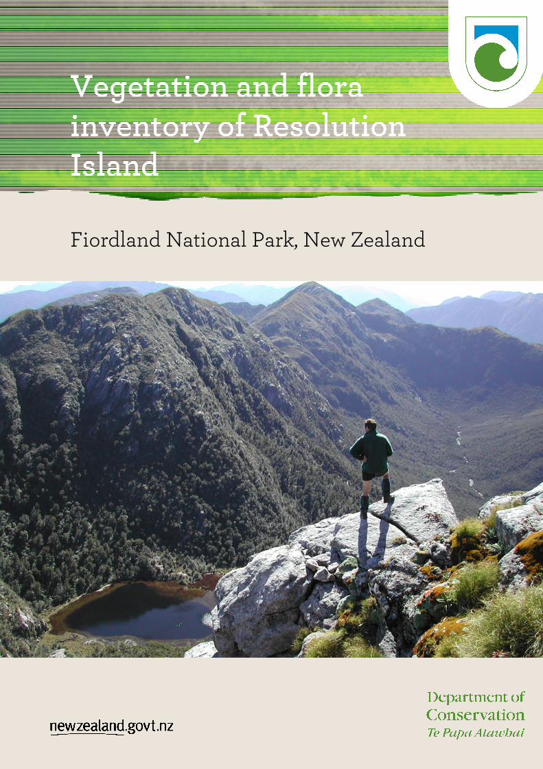
Cover image - Brain Rance looking north-east from near Mt. Roa, Resolution Island, March 2008 (George
Ledgard)
© Copyright August, 2011, New Zealand Department of Conservation
Published by
Department of Conservation, Southland Conservancy
PO Box 743, Invercargill, New Zealand
August, 2011
In the interest of forest conservation, we support paperless electronic publishing.

Vegetation and flora inventory of Resolution Island
Fiordland National Park, New Zealand
George A. Ledgard1; Brian D. Rance1; Richard Ewans2, and Sue Lake2
1Southland Conservancy, Department of Conservation, PO Box 743 Invercargill, 9840, New Zealand
2Te Anau Area Office, Department of Conservation, PO Box 29, Te Anau, 9640, New Zealand.
Email: [email protected]

Contents
Executive summary 1
1. Introduction 2
2. Background 3
3 Geology and Soils 4
4. Methods 6
5. Vegetation 7
5.2.1 Alpine and Upland Vegetation 9
5.2.2 Tussocklands 9
5.2.3 Shrublands 11
5.2.4 Forest 12
5.2.5 Coastal 14
5.2.6 Wetlands 15
5.2.7 Other 17
6. Flora 18
7. Fauna 22
8. Deer Impacts 24
9. Conclusions 27
10. Recommendations 28
10.1.1 Outcome monitoring for deer control: 28
10.1.2 Weed monitoring: 29
11. Acknowledgements 31
12. References 32
Appendix 1. Birds recorded 34
Appendix 2. Mini Recce and NZVCM description 35
Appendix 3. List of waypoints 40
Appendix 4. Map of waypoints 44
Appendix 5. Species recorded on Resolution Island and other sites in the Preservation Ecological
District 45

1
Executive summary
Resolution Island is situated in the southwest corner of Fiordland National Park between
the entrances to Breaksea and Dusky sounds. At 20,860ha Resolution Island is the seventh
largest island in the New Zealand archipelago and the largest island in New Zealand to
undergo a pest eradication attempt. Detailed vegetation surveys on Resolution Island and
within the wider Preservation Ecological District have been limited. With increased access
to this remote part of New Zealand, the opportunity was taken by the Department of
Conservation to conduct a comprehensive vegetation survey of the island while also
assessing the suitability of vegetation monitoring options to measure the outcomes of deer
eradication. The island was divided into four study areas and in March 2008 four staff
covered a study area individually over 10 days completing an inventory of the vegetation
using the unbounded Recce method and a condensed form of this method.
Diverse plant communities extending from the coastal environment, through forest habitat
up into the alpine environment were surveyed and comprehensively described. These
communities included localised and unusual communities as well as extensive
communities.
In total, 414 species have been recorded on the island making it more species rich than
Secretary Island, the second largest island in Fiordland. Threatened plants were inventoried
and a number of threatened species were found including Carex littorosa and all three
beech mistletoe species. In addition several plants of the umbrella fern Sticherus tener were
found at two locations and collected specimens identified were able to confirm this species
as present in New Zealand. Several new records to the Preservation Ecological District have
also been added, along with the identification of a number of new weed species for the
island.
The survey highlighted significant red deer (Cervus elephus scoticus) browse in lower
altitude, fertile, mesic sites and some alpine areas, where a distinct lack of palatable plant
species was observed within the browse tier. It is recommended that outcome monitoring
for deer control occurs, with Seedling Ratio Index (SRI) lines being established as a
minimum for forest habitats. For alpine sites, either Wraight 20x20m plots or Scott height-
frequency transects are recommended to assess the response of alpine vegetation to the
removal of deer.
Keywords: Resolution Island, Fiordland National Park, flora, vegetation inventory, Sticherus
tener, red deer, plant communities.
This paper may be cited as:
Ledgard, G. A.; Rance, B. D.; Ewans, R.; Lake, S. 2010. Vegetation and flora inventory of Resolution Island, Fiordland National Park, New Zealand.

2
1. Introduction
Introduced mammalian herbivores such as deer have had a major modifying effect on the
vegetation of New Zealand. Indeed, there are few places within the New Zealand
archipelago that are free from these introduced herbivores. There has been much progress
and many successes in removing introduced animals from islands. As a result of these
successes larger islands and additional species have been targeted in eradication
programmes. In 2003 a proposal was put to Treasury for the eradication of both stoats and
deer from Secretary and Resolution Islands. This funding bid was approved in 2004.
Resolution Island is a significant island, at 20,860ha it is not only the largest Fiordland
island but also the seventh largest island in the New Zealand archipelago. The island
extends from sea level up to the summit of 1069m on Mt Clerke and contains much
ecological diversity with extensive forest areas, several alpine areas, wetlands and a variety
of coastal habitat. The island is also important due to the fact that there are currently only
three introduced mammals on the island; stoats, red deer and mice. The island has never
been colonised by possums and rats reportedly disappeared off the island after the arrival of
stoats.
Secretary Island has received considerable botanical attention (e.g. Mark, Wardle & Baylis
1963; Mark & Baylis 1975; Mark, Baylis & Dickinson 1991; Monks et al. 2005) and
consequently its vegetation and flora are well documented. However Resolution Island is
relatively poorly described compared with many other Fiordland islands (especially
Secretary, Breaksea and Anchor Islands) and comprehensive flora surveys within this
region have been limited to the West Cape district (Wardle et al. 1963). The major survey
information available for the island is for the Disappointment Cove area (conducted by
Peter Johnson, 1992) and other localised surveys by DOC Southland Conservancy botanist,
Brian Rance.
In order to fully determine the ecological benefits of the removal of introduced animal pests
it is important to have an accurate assessment of the ecological resources present on
Resolution Island. The flora and vegetation represent major ecological resources that
required further investigation. This examination was the major function of the expedition.
The objectives of the expedition were:
• To describe the major vegetation types present on Resolution Island.
• To find and assess populations of threatened flora species.
• To compile a comprehensive flora list for the island.
• To consider the effect of deer upon the vegetation.
• To assess the suitability of different parts of the island for vegetation outcome
monitoring of the forthcoming deer eradication attempt.
• To record fauna sightings of interest including invertebrates.

3
2. Background
Formal vegetation surveys on Resolution Island have been limited with only localised
shore-based surveys being conducted at Five Fingers Peninsula and Disappointment Cove
by Brian Rance and Peter Johnston respectively. In the wider area (within the Preservation
Ecological District) surveys have been conducted on the Dusky Sound Islands (Rance
2002), Breaksea Island (Allen et al. 1990), and at West Cape (Wardle et al. 1973). These
surveys have provided some data on the flora of the area but are still inadequate in
comparison to the other intensively managed islands on the western Fiordland Coast e.g.
Secretary and Anchor Islands. The larger size of Resolution Island and the presence of Five
Fingers Peninsula have resulted in the occurrence of a variety of habitats and ecosystems
not found on these other islands and the likelihood of a greater diversity of plant species.
Major areas of potentially different vegetation on the island were identified as key areas for
botanical investigation. These priority sites were:
• Alpine areas (especially Mt Roa – the most extensive alpine area and Mt Clerke
– the highest alpine area).
• Coastal sites, especially beaches (e.g. Disappointment Cove); estuaries (e.g.
Goose/Woodhen Coves and the head of Duck Cove); and other open coastal
sites.
• North facing forest areas (these are expected to be more fertile and hence
favoured deer habitat).
• South facing forest areas.
• Five Fingers Peninsula (past work has indicated some differences in forest and
other vegetation).
• Other habitats that may be identified, in particular rock faces/outcrops,
wetlands and valley floors.
• Areas of different geology (the island is dominated by granite, therefore other
geological substrates may contain additional species).
On the basis of these prioritised sites and values the island was divided into four study
areas for the survey which was carried out between 2-11 March 2008.. The survey team
consisting of four people was split with each team member being responsible for
undertaking the survey in one of these study areas. This split was as follows:
South-west - Brian Rance
East - Sue Lake
North - George Ledgard
Five Fingers Peninsula - Richard Ewans

4
3. Geology and Soils
3.1 Geology
Plutonic rocks, of which c. 95% are granitoids, comprise c. 60% of the basement rocks in
southwest Fiordland and include the Resolution and Anchor Island groups. These episodes
of plutonism have occurred in response to terrane amalgamation, continental thickening,
and subduction along the alpine fault offshore of Resolution Island, resulting in the
development of the Southwest Fiordland upthrust landscape of which the island is a part of
(Allibone et al. 2007).
The island is dominated by paragneiss and granulite of the Paleozoic period with some
extrusions of biotite-schist and paragneiss, marble and quartzite around the
Disappointment Cove area (DSIR 1958). Exposed domes and outcrops of these granitoids
and gneiss occur along the central ranges of the island from Mt Roa through to Mt Wales
and at the northern end of Five Fingers Peninsula. The western and eastern sides of the
mainland of the island are dominated by diorite and gabbro while the remainder of Five
Fingers Peninsula consists of variably foliated biotite hornblende tonalite, quartz diorite
and diorite (Allibone et al. 2007). There is also an unusual occurrence of fossiliferous
mudstone on the southeastern shore of Five Fingers Peninsula with thin coal seams present
(Turnbull & Lindqvist 1981). The distinct shape and topography of the peninsula results
from relatively young (Pliocene to Pleistocene; 1.5-3Ma) marine upthrust benches being
forced up between the Alpine Fault offshore and a major fault system running up the
inshore of the peninsula.
Although looking similar to the landscape around it, Resolution Island is unique in its
geological composition and its combination of plutonics is not replicated in any other
landscape in southwest Fiordland. In saying this, the chemo-geological effect on fertility is
negligible within this landscape and this has resulted in infertile soils in many places. Of
geological interest is the discovery of an area of marble outcrop and associated sinkholes
near Mt Wales. Its influence on soil fertility and plant composition warrants further
exploration at the site.
3.2 Soils
Soils on Resolution Island vary with topography and elevation with distinct variations on
Five Fingers Peninsula, Wood Hen Cove and lower elevation sites on the northern coast
and at Duck Cove. Soils are described under the NZ genetic soil classification (Hewitt 1998).
The dominant soils are acid brown soils and podzols , which cover much of the higher
elevations and lower graded topography on the island (DSIR 1962; DSIR 1964). Recent soils
occur in exposed areas or areas of high soil disturbance and impeded development.
Glaciation has removed soils from some areas with extensive areas of scratched rock and
skeletal soils around areas such as Mt Roa. Five Fingers Peninsula is characterised by its
topographical nature which is similar to that of the West Cape, with uplifted mudstone and
conglomerate marine benches overlain with acid brown brown soils and podzols
interspersed by blanket peats/organic soils (DSIR 1964; Wardle et al. 1963). Sandy recent

5
soils characterised by dunes and alluvial outwashes are present at the head of Woodhen
Cove, while the lower elevated areas of the north coast and Duck Cove contain more fertile
brown soils. Gley recent soils are present adjacent to some of the larger rivers near the coast
(DSIR 1962; DSIR 1964). Gravel beach associations are sparse with the only significant site
being the gravel beach and bar in Disappointment Cove. One other minor gravel beach was
observed at the mouth of the largest river on the north coast (remains unnamed).
Salt marsh and estuarine systems consisting of marine sands and outwash silts and clays
are minimal but present at the head of Woodhen/Goose Cove and Duck Cove.
In general, nutrient availability from plutonic rocks is low however where sufficient soil
formation has occurred and soil temperature is adequate (such as north facing alluvial
gullies) fertility is high (McLaren & Cameron 1990), supporting a diverse range of forest
species.

6
4. Methods
Each team member completed vegetation assessments of distinct vegetation communities
that they encountered. These vegetation assessments were conducted in two forms. The
unbounded Recce method (see Hurst & Allen 2007a) was used as a more formal description
of sites of interest while a condensed Recce method (hereafter known as the mini Recce
method) was used where there were time constraints or limited vegetation significance
and/or diversity.
Recce method (unbounded): All data was recorded on the 2007 version of the National
Vegetation Survey Databank (NVS) Recce sheet (See Hurst and Allen 2007a) to standard
NVS protocol. The exceptions to this method were:
Plot layout was not recorded due to the Recce’s being unbounded;
Mesoscale topographic index not completed due to the lack of hypsometers being available;
Cover scores were given a percentage not a cover class in some instances (note: a ‘+’
denoted <1% cover).
Mini Recce method: This method was a reduced form of the Recce. Essentially it
incorporated the back page of the Recce (i.e. plant species present) with basic cover scores
and a few location descriptors. These forms were recorded within field notebooks. For an
example see Appendix 2.
Flora recording: An inventory of plants observed during the study was made. In some cases
several lists within a study site were completed. Additional notes were made on locations of
threatened plants, other notable plant records and palatable plant species abundances or
distributions.
All plant specimens unidentifiable in the field were collected, pressed and formally
identified back in the office. The remaining specimens whose identification could not be
confirmed were sent through to the Plant Identification Service at Landcare Research. In
addition some voucher collection specimens have been lodged at the Allen Herbarium and
additional specimens (ferns and Hebe spp. samples only) were identified and lodged at Te
Papa/National Museum of New Zealand.
Other records: Notes were made on locations of indigenous fauna, deer sightings, deer
impacts (including browsing, tracking and other deer sign) and other notable observations.

7
5. Vegetation
A total of 36 Recce Plots and 78 mini Recces were completed. Although the whole island was
not covered, the survey captured most key vegetation communities resulting in a
comprehensive flora list for the island. Alpine tops and forests in the central, southern and
eastern parts of the island were inventoried by Brian, Sue and George. Richard spent ten
days intensively exploring Five Fingers Peninsula and Goose Cove. Coastal forest, rocky
shorelines and coves along the north coast were visited by George. Swamps, valley floor
forests, salt marshes and bogs were also inventoried.
Overall the survey was comprehensive and most flora species expected to be on the island
were encountered along with some new recordings for the area. Notably Sticherus tener,
only recorded once previously in New Zealand, on Five Fingers Peninsula, was confirmed at
several locations on the island.
There were still some deficiencies however, and naturally rare ecosystems such as marble
outcrops and flushes need further investigation along with other communities which were
underrepresented in the surveys. The steep eastern side of the island (above Acheron
Passage) would also benefit from additional work.
5.2 Vegetation communities
A number of vegetation communities are present on the island, their distribution being
largely driven by aspect, altitude and soil development. Outlined in the below table are the
vegetation classes that occurred on the Island, their composition and distribution, and
structure. The New Zealand Vegetation Cover Map (NZVCM) classes (Newsome 1987)
were used as a descriptor of forest type. A summary of all the descriptor classes is in
Appendix 2.
Table 1 below shows a summary of the vegetation communities sampled and a brief
description of those communities.
Table 1: Summary of vegetation communities on Resolution Island.
Bio Climatic Zone
Vegetation Community
NZVCM Class
Composition Distribution Canopy Ht (M)
Altitude Plots R=Recce r= mini Recce
ALPINE Chionochloa acicularis tussockland
G4 Chinochloa acicularis, Celmisia spp., Carpha alpina and other associated species
Alpine tops 0.5 >700m 2R, 1r
Chionochloa pallens and C. rigida subsp. amara tussockland
GS4 Chinochloa pallens, Hebe odora and Dracophyllum spp. dominated tussock-shrubland
Alpine tops <1.5 >800m 1R, 1r
Fell field, exposed rock turf communities
M1 Set amongst rocky crags, scree and exposed granite domes. Low vegetation cover with prostrate shrub and plant communities
Mt Lort <0.5 >550m 1R, 6r
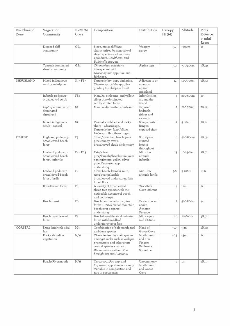
8
Bio Climatic Zone
Vegetation Community
NZVCM Class
Composition Distribution Canopy Ht (M)
Altitude Plots R=Recce r= mini Recce
Exposed cliff community
GS4 Steep, moist cliff face characterised by a mosaic of shrub species such as moss Epilobium, Gaultheria, and Bulbinella spp., etc
Western range
<0.5 >600m 1r
Tussock dominated shrub community
GS4 Chionochloa acicularis interspersed with Dracophyllum spp., flax, and Hebe spp.
Alpine tops 0.5 700-900m 3R, 3r
SHRUBLAND Mixed indigenous scrub – subalpine
S3 – FS7 Dracophyllum spp., pink pine, Olearia spp., Hebe spp., flax grading to subalpine forest
Adjacent to or amongst alpine grassland
1.5 500-700m 2R, 5r
Infertile podocarp-broadleaved scrub
FS2 Manuka, pink pine and yellow silver pine dominated scrub/stunted forest
Infertile sites around the island
4 200-600m 6r
Leptospermum scrub dominated shrubland
S2 Manuka dominated shrubland Exposed bedrock ridges and swamps
2 200-700m 2R, 5r
Mixed indigenous scrub – coastal
S1 Coastal scrub belt and rocky shore – Olearia spp., Dracophyllum longifolium, Hebe spp., flax, three finger
Steep coastal fringes, exposed sites
2 5-40m 2R,1r
FOREST Highland podocarp-broadleaved-beech forest
F5 Silver/mountain beech, pink pine canopy over a broadleaved shrub under story
Sub alpine stunted forests throughout
6 500-600m 2R, 3r
Lowland podocarp-broadleaved-beech forest, infertile
F4 – FS3 Rata/silver pine/kamahi/beech/rimu over a mingimingi, yellow silver pine, Coprosma spp. understorey
Mid - low altitude infertile
25 100-300m 2R, 7r
Lowland podocarp-broadleaved-beech forest, fertile
F4 Silver beech, kamahi, miro, rimu over palatable broadleaved understorey, fern forest floor
Mid - low altitude fertile
30+ 5-200m R, 1r
Broadleaved forest F8 A variety of broadleaved shrub-tree species with the noticeable absence of beech and podocarps
Woodhen Cove isthmus
4 11m 2r
Beech forest F6 Beech dominated subalpine forest - >85% silver or mountain beech over a sparse understorey
Eastern faces above Acheron Passage
12 500-800m 4r
Beech broadleaved forest
F7 Beech/kamahi/rata dominated forest with broadleaf understorey over fern
Mid slope – mid altitude
20 20-600m 5R, 7r
COASTAL Dune land with tidal fan
M3 Combination of salt marsh, turf and dune species
Head of Goose Cove
<0.5 <5m 2R, 2r
Rocky shoreline vegetation
N/A Characterised by matt species amongst rocks such as Isolepis praetextata and other short coastal species such as Blechnum banksii and Poa breviglumis and P. astonii.
North coast and Five Fingers Peninsula Shoreline
<0.5 <5m 2r
Beach/Rivermouth N/A Carex spp., Poa spp. and Coprosma spp. shrubs – weedy. Variable in composition and rare in occurrence.
Uncommon – North coast and Goose Cove
<2 1m 2R, 1r

9
Bio Climatic Zone
Vegetation Community
NZVCM Class
Composition Distribution Canopy Ht (M)
Altitude Plots R=Recce r= mini Recce
WETLAND Lake margin/wetland
M2 Dominated by rushes and sedges and freshwater aquatics such as Potamogeton spp.
Uncommon <1.5 600m 1r
Cushion bog N/A Characterised by Donatia novae-zelandiae, Drosera spp., Oreobolus spp., and other cushion bog species
Mt Roa, Five Fingers Peninsula
<0.5 600-850m 3R, 3r
Manuka wetland S2 Ecotone between bog areas and forest – manuka interspersed with stunted infertile forest spp. such as pink pine and mountain beech.
On the margins of valley floor bogs
<4 100-650m 3R
Lowland-montaine wetland
M2 Mixture of Chionochloa acicularis with moss interspersed with other wetland monocots
Poorly drained inter-montane basins and valley floors, Five Fingers Peninsula
<1 50-700m 3R, 8r
OTHER River banks N/A Varied depending on substrate and species rich – very diverse
Island wide 0.5-30 20-200m 1R
Slip/regenerating bush
FS3 Regenerating broadleaf species and herbs amongst crown fern, heavily browsed
Exposed steep faces and windswept ridges
3 400-100m 1r
Marble outcrop N/A Localised outcrop of marble with species that prefer higher fertility situations than the surrounding landscape exhibited: Fuchsia, pate and ribbonwood.
East of Mt Wales
8 498 1R
5.2 Community descriptions
5.2.1 Alpine and Upland Vegetation
There are several alpine areas the most extensive being Mt Roa - Mt Lort, North Phillips, Mt
Phillips, and Mt Clerke. Other smaller alpine areas include Mt Wales, Mt Lyall, Mt Forbes,
and other un-named peaks and ridges. In addition, there are other areas of open vegetation
below treeline in exposed areas and on shallow soils.
5.2.2 Tussocklands
There were five species of snow tussock encountered; Chionochloa acicularis and C.
crassiuscula are both widespread and common, while C. pallens, C. rigida and C. ovata are
both localised and uncommon.
Chionochloa acicularis tussockland
Recce: Roa 5 & Roa 6, SW 5 & SW 7
Altitude: c. 700 -1069m
This community is the most extensive alpine community. The community has minor
variability dependent upon site conditions. Typically the community is dominated by C.
acicularis with a cover of 40-75% (average 55%) cover and a canopy height of 30-80cm

10
(average 50cm). Other major associated species include Chionochloa crassiuscula (1-10%,
average 5%), Celmisia petrieii (1-8%, average 3%), Carpha alpina (1-8%, average 2%),
Dracophyllum pearsonii (0-5%, average 1%), D. menziesii (0-5%, average 1%), Astelia linearis
(0-5%, average 1%), Uncinia viridis (1%), Pimelea gnidia (0-4%, average <1%), D. longifolium (0-
2%, average 1%), Celmisia verbascifolia (0-2%, average 1%). Other widespread but minor
associates include Gentiana montana, Aciphylla lyallii, Celmisia du-reitzii, Anisotome
haastii, Schoenus pauciflorus and Oreobolus impar.
On damp sites the community contains more Chionochloa crassiuscula (10-20%), Carpha
alpina (c. 15%), Astelia linearis (c. 10%), Schoenus pauciflorus (c. 2%) Celmisia du-rietzii (c.2%)
and locally Donatia novae-zelandiae, Oreobolus strictus, Bulbinella gibbsii and Coprosma
elatirioides. Within the C. acicularis tussockland are localised areas where pineapple shrub
(Dracophyllum menziesii), pink pine (Halocarpus biformis) or leatherwood (Olearia
colensoi) may dominate.
The community grades into cushionbog/wetland on sites with impeded drainage; shrub-
tussockland generally at lower altitudes and on less exposed sites; and into sparsely
vegetated communities on eroded granite surfaces. In addition C. acicularis can dominate
on valley floor wetlands. These communities are described elsewhere in this report.
Chionochloa crassiuscula tussockland: Although widespread and locally common,
especially on damp sites, it is seldom dominant. Therefore this vegetation is best considered
a variant of C. acicularis tussockland.
Chionochloa pallens and C. rigida subsp. amara tussockland
Recce: Clerke 1
Mini Recce: G8
Altitude: c.900m
This community is very localised on the Mt Roa range whereas extensive areas occur on the
Mt Clerke range. The site on Mt Roa occupied a gully (c. 100x10m). The community was
dominated by Chionochloa pallens (c. 50% cover), with Dracophyllum menziesii (18%), Hebe
odora (15%), Celmisia verbascifolia (2%), Anisotome haastii (1%). A notable feature of this
community is Dracophyllum fiordense (1%).
On Mt Clerke the area surveyed had extensive deer damage with species such as
Chionochloa rigida subsp. amara and Anisotome haastii exhibiting heavy browse including
numerous dead C. rigida stumps. The community here was far more diverse with almost
double the species recorded. Dominant species included Chionochloa rigida subsp. amara
(5%), C. pallens (5%), Poa colensoi (c. 60%) and Oxalis lactea (c.20%). A similar community
was found near the summit of Mt Wales.
Fellfield, exposed rocky turf communities
Mini Recce: G1
Altitude: c.916m
This community is distinctive though localised and of limited extent. It occupies exposed
sites on ridges (e.g. saddles) at higher altitudes. At the study site the community consisted
of Dracophyllum politum (22%), Raoulia buchananii (10%), Chionochloa crassiuscula (2%),
Oreobolus impar (2%), Celmisia sessiliflora (1%) and other species in smaller amounts. The

11
total vegetation cover is variable but up to c. 60% with the remainder of the cover consisting
of mainly rock and gravel.
Shrub-tussockland
Recce: Roa 4
Altitude: c.500-650m
This community is widespread but fragmented. Though the community is transitional
between shrubland and tussockland it is sufficiently widespread to be included in its own
right. It is found on relatively exposed sites and generally on shallow soils. The canopy is
generally less than 1m tall, with the average height being c. 50cm. The community is
generally dominated by Chionochloa acicularis (c.30%) and manuka (25%). Other
components include pink pine (Halocarpus biformis) (4-10%), Carpha alpina (4-8%), Astelia
linearis (2-6%), inaka (Dracophyllum longifolium, 3%), mountain beech (Nothofagus solandri
var. cliffortioides, 3%), Gahnia procera (2%), Oreobolus impar (2%), O. strictus (1%), prickly
mingimingi (Leptecophylla juniperina), Gentiana montana, and other species.
5.2.3 Shrublands
Subalpine shrubland
Recce: Roa 8,
Mini Recce: Roa 3, Roa a1 & Roa a4
Altitude: c.780m
This community is found bordering the alpine to sub alpine tussocklands around the higher
elevation sites on the island. With decreasing altitude there is a graded transition into
higher stature vegetation which is described in the forest classifications. Prominent species
within this community consist of Halocarpus biformis (c.30%), Olearia colensoi (c.15%),
Dracophyllum spp. (c.15%), Nothofagus spp. (c.10%), Astelia spp. (c.5%), Phormium tenax
(c.2%). Other uncommon but distinguishing species are Pseudopanax colensoi var. fiordense
within the browse tier, Gahnia procera and Myrsine nummularia.
Podocarp - broadleaved shrubland - infertile
Recce: RR5
Mini Recce: Roa a4, R1 & G14
Altitude: c.400 – 700m
This is probably the most widespread shrubland community on the island. Its species
composition appears to be highly influenced by low soil fertility brought about in most
instances by impeded drainage. At higher altitude this shrub class has been differentiated
into a Subalpine Shrubland class (see previous paragraph), which is more mixed in species
composition and probably occurs on more fertile sites. Its typical composition is dominated
by Halocarpus biformis (c 40% canopy cover) (and Lepidothamnus intermedius on five
fingers) with Metrosiderous umbellata, Nothofagus menziesii and Leptospermum scoparium
comprising the remainder of the canopy. The sub canopy, if there is one, is sparse with

12
Dracophyllum menziesii (3%), Leptecophylla juniperina (2%) and Astelia spp. Ground covers
are usually dominated by bryophytes (c.50%) and litter (c.30%).
Manuka dominated shrublands
Recce: Roa 3
Mini Recce: Plateau Biv, Roa a6, SWa10 & SWa6
Altitude: c.550
These shrublands are highly variable with manuka varying in cover and stature. However,
there are some similarities and associations that allow this category to be used to document
a significant component of the island’s shrublands. This shrub type could be broadly
classified into two categories, high stature (2-5m) and low stature (<1.5m). The high stature
shrubland comprises Leptospermum scoparium (c.40%) and stunted forest species such as
Nothofagus solandri var. cliffortioides, Metrosiderus umbellata, Dracophyllum spp. and
Halocarpus biformis (totalling c.40%). The understorey was often sparse and the community
was often found at higher altitudes. Communities with almost 100% Leptospermum canopy
cover were found on infertile well drained ridges at mid altitude sites, however these were
the least common sub community. The low stature sites were much more diverse and
Leptospermum was less dominant and patchy in its overall presence. These sites were often
infertile or had impeded drainage. Associated species within this community were Carpha
alpina, Chionochloa acicularis, Astelia linearis var. linearis, Gentianella montana var.
montana, Donatia novaezelandiae and Drosera spp. These sites are closely linked to the
manuka wetland margin descriptions further on in the text.
Coastal shrub
Recce: NW4
Mini Recce: G14, R10 & R14
Altitude: c.10m
This community was most commonly found on exposed coastal slopes, particularly on the
western and northern sides of the island. The dominant shrub in this zone is Olearia
oporina (c.50%) with Dracophyllum longifolium (c.20%) sometimes dominating in localised
patches. Other common species are Phormium tenax (c.5%), Hebe elliptica, (c.5%)
Brachyglottis rotundifolia and Austroderia richardii.
5.2.4 Forest
Highland podocarp-broadleaved-beech forest
Recce: Roa 2, BR2, G1, RR5 & G14
Mini Recce: Roa a8, SWa7, SL8 & SL11
Altitude: c.600m
These forests are characterised by the presence of pink pine (Halocarpus biformis) (20%),
co-dominant with rata (20%), kamahi (30%) and mountain/silver beech (40%). The
understorey also contains species associated with this infertile habitat such as
Dracophyllum longifolium (5%), Olearia colensoi (10%), Archeria traversii (5%) and Myrsine

13
divaricata (5%). The forest floor is often open with a distinct lack of groundcover from
species such as ferns etc.
These forests are often found on poorly drained, infertile ridgelines, often with bedrock
close to the surface.
Lowland podocarp-broadleaved beech-forest - infertile
Recce: SW11, SW4, SW12, RR6, RR2 & RR1
Mini recce: R3, R9, R13, R17 & G17
Altitude: c.60m
Similar to the above description however distinguished by the presence of some of the taller
podocarps in less exposed sites. Rimu, miro, pink pine and totara dominate along with
pokaka, beech and kamahi to make up a taller statured forest overlying a relatively sparse
understorey of prickly mingimingi, coprosma spp. and other small leaved shrubs. Sites
where this forest type was present were flat, infertile boggy areas, often with standing water.
Lowland podocarp broadleaved beech forest - fertile
Recce: SW1
Altitude: c.10m
This fertile valley floor forest was characterised by the diversity of the forest and the
presence of a variety of palatable tree species such as mahoe, pigeon wood, pate and
fuchsia. The canopy was dominated by podocarps and beech with numerous epiphytes,
notably kiekie, which was not found anywhere else on the island. High levels of deer in the
area have impeded regeneration and the forest floor is dominated by crown fern (Blechnum
discolor). The largest tract of this forest was in the Disappointment Cove valley while some
small pockets were observed at the mouths of some of the larger rivers.
Broadleaved forest
Mini Recce: R15 & G16
Altitude: c.8m
The two locations of this forest type were on the isthmus of Woodhen Cove and on a steep
dynamic river bank, 400m inland on the north coast. The canopy height was low with
nothing present over four meters. A number of highly palatable forest species were present
with species such as pigeonwood, fuchsia, rata, broadleaf and karamu occurring (although
not within the browse tier at Goose Cove). Understorey species consisted of mainly non-
palatable grasses and ferns such as Blechnum discolor, Microlaena avenacea and Uncinia
unciniata. However, when access to deer was restricted a number of deer-preferred species
were observed such as Asplenium bulbiferum and fuchsia and marble leaf seedlings.
Beech forest
Recce: SW9 & RR3
Mini Recce: SL18, SL19, G11, Ba3, Ba5, G5, G7 & G15

14
Altitude: c.600m
This forest type was predominant on the high elevated slopes above Acheron Passage on
the eastern edge of the island with localised patches elsewhere. Areas with over 60% beech
dominating the canopy were assigned to this community. Other species present in the
canopy were most often kamahi and rata. The understorey commonly consisted of ferns
such as Cyathea colensoi and Blechnum spp. along with a variety of Coprosma spp. and
other small-leaved shrubs such as Pittosporum divaricatum sparsely scattered throughout.
Ground covers were dominated by bryophytes (c.70%) and the hook grass Uncinia filiformis
was usually present. Two lowland fertile sites dominated by silver beech were recorded
along the southwest coast. The understorey was more diverse than higher altitude sites and
this forest type may be more common along this coast.
Beech - broadleaved forest
Recce: WALES3, SW6, SW8, NW3 & NW2
Mini recce: SWa1, SWa2, R4, R5, R8, R11, R12, R16, G10, G11, SL9, SL12 & SL13
Altitude: c.500m – sea level.
Beech broadleaf is probably the most singularly dominant forest type on the island. This
forest type typically occurs on mid-to-low altitude, medium fertility, sloped sites. The two
primary dominant species are kamahi and beech. Beech broadleaved forests consist of a
combination of mountain and silver, with silver preferring the more productive sites and
usually the dominant of the two. Other minority species found in the canopy are rata,
broadleaf, marble leaf and Pseudopanax colensoi var. fiordense (epiphytic). In the mid tier
dominants consist of Coprosma foetidissima, C. cuneata, C. ciliata, Cyathea colensoi,
Dicksonia squarosa and others, while the understorey is dominated by Blechnum fern
species. Bush lawyer and supplejack are both common, while some podocarps (miro and
rimu) appear sporadically along the ridges. The lack of palatable plants observed within the
browse tier suggests that these forests hold high deer numbers.
5.2.5 Coastal
Dune land with tidal flats
Recce: RR7, RR8 & RR9
Altitude: 6m
The only extensive community comprised of salt marshes and dunes is located at the head
of Goose Cove. Other isolated patches occur at the head of coves along the south west
coast. The jointed rush, Leptocarpus similis is common around the intertidal zone (c.30%)
along with Samolus repens (c.10%), Isolepis cernuus and Crassula moschata (<5%). Further
inland the community is far more diverse with a number of turf species, rushes, sedges and
grasses present. Common species included Coprosma propinqua, Carex appressa,
Hydrocotyle novae-zealandiae, Centella uniflora and Leptinella squalida. Some stunted
podocarp species such as rimu and totara were also present further inshore.
Beach/Rivermouth
Recce: DISS 2

15
Mini recce: G13
Altitude: 1m
This habitat was very rare and only two sites were found: Disappointment Cove and an
unnamed cove on the North Coast. These sites consisted of a gravel/sand bar with a slight
back beach. Exposure, salt spray, and tidal fluctuations are the dominant environmental
variables which influence these plant communities. Carex, rushes, and sedges were
common at both sites while some locally and nationally rare and threatened species such as
pingao (Ficinia spiralis), kowhai (Sophora microphylla), Coprosma rugosa, mingimingi (C.
propinqua) and saltmarsh ribbonwood (Plagianthus divaricatus) were present at
Disappointment Cove. The pingao appeared to be healthy. The major threat to these sites
are weed invasions (gorse and scotch thistle were noticeable along the coast in some
locations) and intensive deer browsing preventing regeneration.
Rocky shoreline vegetation
Recce: RR10
Mini Recce: G13
Altitude: 1m
This vegetation type is found on the exposed rocky shorelines, typically along the western
and northern exposed coasts. Vegetation is low in stature and consists of plants tolerant to
sea spray. Total cover is dominated by exposed rock while Poa spp. (10%) and Carex
pleiostachys (10%) are dominants. Other common coastal species were Anisotome lyalii,
Lobelia anceps, Sagina procumbens and Blechnum banksii.
5.2.6 Wetlands
Cushion bog
Recce: Roa 9 & RR5
Mini Recce: Roa a5, R2 & R6
Altitude: 680-860m
This community is widespread and relatively common, although generally on a small scale.
The community grades into Chionochloa acicularis tussockland on better drained sites. The
major components of this community include Donatia novae-zelandiae (25-45%, average
35%), Carpha alpina (5-20%, average 12%), Oreobolus pectinatus (8-15%, average 10%),
Chionochloa crassiuscula (5-8%, average 6%), Oreobolus impar (2-10%, average 5%),
bryophytes (5%). Other characteristic species include Dracophyllum prostratum (1-6%,
average 4%), C. acicularis (2-4%, average 3%), Astelia subulata (1-4%, average 2%), Zotovia
thomsonii (2%), Rostokovia magellanica (2%), manuka (+-6%, average 1%), Astelia linearis (+-
5%, average 1%), Gaimardia setacea (1-3%, average1%), Lipparophyllum gunnii (+-3%, average
1%), Actinotus novae-zelandiae (1%), Rytidosperma nigricans, Mitrasacme novae-zelandiae,
Drosera arcturii, Pentachondra pumila, and other species.
Within the cushionbog are pools and areas that are temporarily flooded. These wet areas
tend to be dominated by Lipparophyllum gunnii with Centrolepis ciliata, C. pallida,
Gaimardia setacea, Zotovia thomsonii, Juncus antarcticus, Astelia subulata and bryophytes.

16
Around the margins of the cushionbog the community merges into other adjacent
communities, generally tussockland. A distinctive though discontinuous community that
was sampled contains Chionochloa crassiuscula (15-30%, average 22%), C. acicularis (10-20%,
average 15%), Carpha alpina (10-20%, average 15%), Donatia novae-zelandiae (5-15%, average
10%), Astelia linearis (5-20%, average 10%), bryophytes (5-12, average 8%), and Oreobolus
pectinatus (1-12%, average 5%). Also present are Dracophyllum politum (3%), Schoenus
pauciflorus (2%), Bulbinella gibbsii, Forstera sedifolia, Drosera arcturii, Zotovia thomsonii,
Hebe odora, and manuka.
Valley floor bogs
Reece: Roa1, SW10 & RR11
Mini Recce: Roa a7, SWa3 & SWa4
Altitude: 120-600m
This community is found on scattered sites on valley floors and depressions. It is generally
small-scale (the largest being > 2ha), though they are generally much smaller (often < 0.1ha).
The community is dominated by Chionochloa acicularis (10-75%, average 30%), with a
canopy height of 30-75cm (average 50cm). Major associated species include much
bryophyte (2-60%, average 20%) and Carpha alpina (15%). Astelia linearis (0-15%, average
2%), wirerush (Empodisma minus) (0-35%) and manuka (0-10%) are not always present,
however at some sites are common. Other associated species include Donatia novae-
zelandiae, Oreobolus pectinatus, O. strictus, Drosera spathulata, D. arcturii, Lycopodium
ramulosum, Gaimardia setacea, Zotovia thomsonii, Actinotus novae-zelandiae,
Liparophyllum gunnii Pentachondra pumila, Deyeuxia aucklandica, and other species. Litter
is generally common (c. 20% cover). Sprengelia incarnata and Lepidospermea australe may
be characteristic species at some lower altitude sites.
Manuka wetland
Recce: RR4, Diss 1 & SW 3
Altitude: 100-650m
This community is on wet, peaty soils, often around the margin of valley floor bogs. The
vegetation is a semi-open shrubland, the woody component is dominated by manuka (up to
4m tall) generally with some pink pine, yellow silver pine, inaka and mountain beech. The
understorey often includes Gahnia procera. The ground cover generally contains much
bryophyte along with Donatia-novae-zelandiae, Carpha alpina, Oreobolus strictus, O. impar,
Lycopodium ramulosum, Actinotus novae-zelandiae, Centrolepis ciliata, and other species.
Lake margins
Mini Recce: Roa 06
Altitude: 670m
Around the margin of a lake north of Mt Lort is a wetland community. This community is
distinctive though localised. The major vegetation is Isolepis aucklandicus (30%) and
bryophyte (25%), with Carpha alpina (15%), Juncus antarcticus (10%), Chionochloa acicularis
(5%), Schoenus pauciflorus (5%), Juncus bulbosus (5%), Hebe odora (2%), Chionochloa
crassiuscula (1%), and several other species in minor amounts.

17
5.2.7 Other
River Banks
Recce: NW3
Altitude: 20m
Only one Recce was conducted on a river bank however the diversity of vegetation was very
high with several communities present within this area e.g. dynamic gravel river bed, low
light, wet stable channel, sheltered, steep mossy bank and terrace edge/forest floor. The
fertile terrace edge forest was a mix of beech-podocarp-broadleaf species, while the moist
mossy bank and stream held a variety of Hymenophyllum species and palatable species
such as Asplenium bulbiferum in areas inaccessible to deer. The river bank which was
exposed to flooding was the residence of many small herb species and creepers such as
Hydrocotyle moschata, Oxalis exilis and Lobelia angulata.
Regenerating forest
Mini Recce: G12
Altitude: 400m
These sites tended to occur on the steep coastal country where slips had occurred or along
ridges where wind throw had occurred. Mountain beech was the main canopy species that
was seen to be regenerating, however the regeneration of other canopy species has been
impeded by heavy deer browse. These sites are often diverse with a number of herbs and
small perennials present. Dominant species include; Coprosma cuneata (20%), C.
pseudocuneata (20%), Blechnum procerum (20%), B. discolor (15%), and Nertera depressa
(2%).
Marble area to the east of Mt Wales
Recce: SL17
Altitude: 498m
This site was a damp forested area with large marble boulders and a sink hole
approximately 20m deep and 15m wide. The species encountered here are indicative of a
fertile site with pate, fuchsia, and ribbonwood all present. The floor of the sink hole was a
damp area with no trees present. Two plants found that are of particular interest were
Myosotis spathulata and a small Asplenium bulbiferum which is possibly the marble
specific A. cimmeriorum (due to small size and lack of bulbils). This is an unusual habitat
and definitely warrants further investigation.

18
6. Flora
This survey confirmed that Resolution Island has a very rich flora, with 411 indigenous
species recorded (see Appendix 5). The flora is highly representative of the Preservation
and southern Doubtful Ecological Districts. Notably this survey adds several new records to
our knowledge of the flora of the Preservation Ecological District (south-western Fiordland).
Future additional survey work is expected to further increase the known flora of Resolution
Island. It is noted that there are several species that have been recorded from adjacent
Dusky/Breaksea Sound Islands that were not recorded in this survey. In addition, there are
some species recorded from the Secretary Island and West Cape area that also were not
recorded. It is likely that the total flora could be in the vicinity of 450 indigenous species.
The richness of the flora recorded is largely a consequence of the size of the island, the
diversity of habitat available, and the intactness of the habitat. While it was not possible to
survey the island in its entirety, all major habitats and major portions of the island received
some attention. The south-western portion of the island contained the richest flora (291
species) which is largely a consequence of the diversity of habitat covered. Five Fingers
Peninsula was the least diverse area, which is probably a reflection of the relative lack of
diversity of habitat.
The diversity of the major different life forms is presented in Table 2. The greatest diversity
within the flora was that of herbaceous species (114 species), trees and shrubs (85 species),
and ferns (77 species). These groups represent 67% of the flora.
Table 2: Plant diversity of the major different plant life forms found on Resolution Island
(SW=South-west, SE=South-east, N=North, FF=Five Fingers Peninsula, T=total for Resolution
Island), Dusky Sound Islands (DI), West Cape (WC), Secretary Island (SI).
Plant groups SW SE N FF T DI WC SI
FERN 57 51 58 41 77 61 36 69
PODOCARP 6 4 5 5 6 6 5 8
TREES & SHRUBS 69 61 57 55 85 61 60 78
CLIMBERS & VINES 3 3 5 3 6 5 4 5
HERBACEOUS 67 72 52 43 116 36 26 94
GRASSES 25 19 12 10 32 6 9 26
SEDGES 28 20 26 24 41 27 14 32
ORCHIDS 14 11 13 14 22 13 12 17
RUSHES 10 7 7 9 16 7 3 10
OTHER MONOCOTS 12 10 7 7 13 8 8 13
Total 291 258 242 211 414 235 172 332
The flora is considered diverse compared to other areas of western Fiordland that have been
studied. Of particular note is the richer flora recorded from Resolution Island compared to
Secretary Island (414 c.f. 332 species) despite much more intensive studies on Secretary
Island. Likewise the greater diversity of Resolution Island compared to the flora of other
adjacent, smaller and lower altitude islands in Dusky/Breaksea Sound is highlighted (414 c.f.
230 species). The diversity of Resolution Island compares favourably to the limited
19
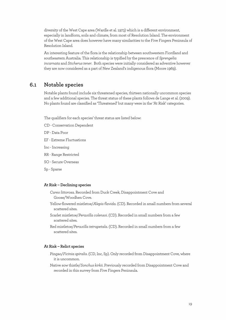
diversity of the West Cape area (Wardle et al. 1973) which is a different environment,
especially in landform, soils and climate, from most of Resolution Island. The environment
of the West Cape area does however have many similarities to the Five Fingers Peninsula of
Resolution Island.
An interesting feature of the flora is the relationship between southwestern Fiordland and
southeastern Australia. This relationship is typified by the prescence of Sprengelia
incarnata and Sticherus tener. Both species were initially considered as adventive however
they are now considered as a part of New Zealand’s indigenous flora (Moore 1969).
6.1 Notable species
Notable plants found include six threatened species, thirteen nationally uncommon species
and a few additional species. The threat status of these plants follows de Lange et al. (2009).
No plants found are classified as ‘Threatened’ but many were in the ‘At Risk’ categories.
The qualifiers for each species’ threat status are listed below:
CD - Conservation Dependent
DP - Data Poor
EF - Extreme Fluctuations
Inc - Increasing
RR - Range Restricted
SO - Secure Overseas
Sp - Sparse
At Risk – Declining species
Carex littorosa. Recorded from Duck Creek, Disappointment Cove and
Goose/Woodhen Cove.
Yellow-flowered mistletoe/Alepis flavida. (CD). Recorded in small numbers from several
scattered sites.
Scarlet mistletoe/Peraxilla colensoi. (CD). Recorded in small numbers from a few
scattered sites.
Red mistletoe/Peraxilla tetrapetala. (CD). Recorded in small numbers from a few
scattered sites.
At Risk – Relict species
Pingao/Ficinia spiralis. (CD, Inc, Sp). Only recorded from Disappointment Cove, where
it is uncommon.
Native sow thistle/Sonchus kirkii. Previously recorded from Disappointment Cove and
recorded in this survey from Five Fingers Peninsula.

20
At Risk - Naturally Uncommon species
Abrotanella muscosa. (RR). Recorded locally from Mt Roa from within moss on wet rock.
Note: previously thought to be a Stewart Island endemic species.
Anisotome lyallii. (Sp). Recorded from coastal habitat.
Brachyglottis bifistulosus. (Sp). Very localised.
Carex pleiostachys. (RR, Sp). Recorded from coastal habitat.
Crassula helmsii. (SO, Sp). Recorded locally from saltmarsh areas.
Gentianella lineata. (Sp). Recorded from alpine bogs.
Grammitis rigida. (Sp). Recorded from coastal rocks.
Myosotis rakiura. (RR, Sp). Recorded from coastal habitat. Note: This appears to be the
first Fiordland record for this species.
Myosotis spathulata. (DP, EF, Sp). Very localised.
Sprengelia incarnata. (SP, SO). Recorded from lowland bogs.
Uncinia viridis. (DP, Sp). Recorded from alpine tussockland.
Other notable species
Celmisia holosericera. Fiordland endemic.
Dracophyllum fiordense. Fiordland endemic.
Drymoanthus adversus. This species is uncommon in Southland and is probably
impacted by possum browsing. Note this record was by P. N. Johnson (1992).
Sticherus tener. This fern had previously been recorded from Fiver Fingers Peninsula ( a
single specimen) and this site was the only recorded site for this otherwise Australian
species (hence its current status as vagrant). During the current survey it was
recorded and collected from a few sites on Five Fingers Peninsula and also from near
Centre Biv. The identification of the specimens was confirmed by Dr. Patrick
Brownsey (Te Papa Tongarewa, Museum of New Zealand), confirming the presence
of this species in New Zealand. Another specimen subsequently collected from the
outlet of the lake on Indian Island (nearby in Dusky Sound) may be this species or
another species of Sticherus, previously unrecorded from New Zealand (Dr. Patrick
Brownsey, pers. comm, 26 August, 2011). Sticherus tener is classified as a Non-
Resident Native-Vagrant (DP, Sp) by de Lange et al. (2009).
Absent/localised species
A number of alpine species were localised in distribution, often with these being found only
on the eastern ridge (or much more common there) rather than Mt Roa. These species
included Chionochloa rigida var. amara, C. pallens, Ranunculus lyallii, Brachyglottis
bellidoides, Celmisia ramulosa, C. walkerii, Crasedia uniflora, Geum uniflorum, Ourisia
caespitosa and Poa colensoi. There is a paucity of alpine Hebe spp. (only H. odora and no
whipcord species), alpine Carex (only one species), bidibid (one species) and speargrass
(two species). For these groups this represents low diversity for Fiordland. No Dolichoglottis
lyallii or alpine bidibid were recorded either.

21
6.2 Weeds
A total of 23 exotic species were recorded from Resolution Island. Most of these exotic
species were confined to open coastal areas. Only two rush species were found in natural
areas within the alpine and wetland habitats. The only weed of conservation concern
recorded was gorse, recorded from Disappointment Cove and Woodhen Cove (see
Appendix 3). Both of these gorse sites are currently managed with annual visits to locate
and spray gorse by Biodiversity Threats staff from the Te Anau Area Office.
The sites containing the most exotic species were Goose/Woodhen Cove (16 species) and
Disappointment Cove Beach (11 species). These findings were not unexpected as both of
these sites frequently receive hunting parties and face the northerly swells which wash up
seed (such as gorse) among the driftwood debris. They are therefore key access and
establishment points for weeds on the island. Exotic species could potentially spread from
these sites to other sites with suitable habitat. The only exotic species recorded from upland
non-forest sites were two exotic rushes - jointed rush (Juncus articulatus) and bulbous rush
(J. bulbosus). Both were localised in natural wetland areas; Mt Roa bivvy area for jointed
rush and on the margin of the lake north of Mt Lort for bulbous rush. These were most likely
introduced by avifauna using the lake.
The bivvy sites are a centre for human activity and associated disturbance (e.g. pugging
and trampling) and/ or vegetation clearance (e.g. helicopter landing pads). On Secretary
Island (8140 ha.) in Doubtful Sound, where a similar pest eradication operation has been
underway for longer, weeds have been introduced by human activity to virtually all of the
newly established bivvy sites (Department of Conservation Te Anau Area Office,
unpublished data). Therefore the Resolution Island bivvy sites are likely sites for weed
invasion. Eleven of the twelve bivvies on the island were visited during the course of the
survey and checked for weeds (only Duck Cove bivvy was not inspected). There was no
evidence of exotic plant invasion at any of these sites, except for the Disappointment Cove
bivvy where some tomato plants were recorded beside the outside tap. The bivvies of
greatest concern for weed invasion are the alpine bivvies and those in non-forest habitats.
At these sites exotic plants that establish have few barriers to restrict their invasion into
surrounding intact habitat. Bivvies in forest environments are less likely to facilitate weed
spread as forest is a barrier to the spread of most exotic species. A check of the bivvy sites
and other at risk sites in December 2010 found weeds at most bivvy sites and at the
lighthouse (Five Fingers Peninsula) and repeater sites. A strategy for dealing with the weed
threat on Resolution Island has been recently implemented (Department of Conservation
Te Anau Area Office 2010).

22
7. Fauna
7.1 Birds
Kiwi call counts were conducted as part of the survey work and numerous kiwi were heard
from the call sites. Sporadic kiwi sign was seen when conducting our vegetation surveys.
Other birds seen were:
NZ falcon, kaka, kea, rifleman, bellbird, waxeye, grey warbler, tomtit, shining cuckoo,
blackbird, greenfinch, brown creeper, wood pigeon, pied shag, whiteface heron, skua, red
billed gull, pipit, fantail, oystercatcher, parakeet, sooty shearwater, morepork, fernbird.
7.2 Invertebrates
Entomological studies on the island have been limited to isolated collections and one
formal study. Bremner et al. (1984) investigated invertebrate levels on Resolution Island,
which has stoats and deer, in comparison to Breaksea Island (rats only) and Gilbert Island
No. 6 (no mammals). It was found that both Breaksea Island and Resolution Island had
lower populations of some species and this finding was thought to be from increased
disturbance and predation by these mammals.
Collections were made of a few insects during the survey. One species collected was the
stag beetle (Geodorcus helmsi). Those that have spent much time on the island thought that
these may be confined to the north of the island (Pete Kirkman, pers. comm., 23 November
2008). During this survey a specimen was observed and collected from south-east of the
The Basin bivvy (Track 3). This finding indicates that they are likely to be widespread on
the island though their density is likely to vary considerably. Two other stag beetles were
collected along the north coast.
Large snail shells (Powelliphanta fiordlandica) appeared to be confined to the southern half
of both the main part of the island and Five-Fingers Peninsula, where caches of empty shells
were found at various sites. Waypoints were taken when such shells were discovered (see
Appendix 3). Several shells were collected on Five-Fingers Peninsula and Mt Clerke ridge
and passed on to DOC Te Anau Biodiversity Assets staff (Hannah Edmonds) to be sent
away for identification.
7.3 Fauna habitat
Several bird species such as the kakapo, North Island kokako, Snares Is. snipe, pateke and
takahe have been identified as potential candidates for transfer to Resolution Island
(Wickes & Edge 2009). The vegetation associations and habitats encountered over the
island varied greatly providing a diverse habitat.
Although the island was not fully investigated by the team, certain vegetation associations
stood out as being valuable habitat for avifauna. Readers should be aware the following

23
observations were made by staff with primarily a botanical focus so any recommendations
and conclusions should be verified by someone with an ornithological background.
Alpine areas consist primarily of tussockland with areas of bluffs and rock outcropping,
boulder fields, wetlands and tarns. In these alpine areas the ranges to the east from Mt
Wales through to Mt Lyall appear to be more fertile, supporting a wide range of palatable
species, albeit this habitat is limited in size. Further to the west the extensive alpine areas of
Mt Roa, Mt Lort and Mt Phillips are relatively infertile, being dominated by Chionochloa
acicularis, with relatively few palatable species present.
Fertile, lowland, broadleaf-podocarp forest is known to support diverse numbers of
frugivorous bird species (O’Donnell & Dilks, 1994) and appeared to hold the highest
numbers of fruit and nectar bearing plant species on the island. Large tracts of this forest
type are known to be present along the north coast and Five Fingers Peninsula, particularly
on the valley floors and lower elevated, stable slopes (c. <100m a.s.l.). Bird-preferred species
such as mahoe, pate, wineberry, fuschia, and pigeonwood were present in moderate
numbers in the canopy however were depleted within the browse tier. Supplejack was
common in the canopy with kiekie locally common around the coast.
Taller podocarp forest containing species such as miro and rimu was scattered around the
island. We are unable to build up a clear picture of where large tracts of this forest exist
however areas such as the valley inland of Duck Cove, and elevated flat areas behind
Disappointment Cove, held large tracts of forest with numerous emergent podocarps.
By far the most dominant forest type was the beech–broadleaved forest occupying all but
the least fertile sites from sea level to 650m a.s.l. This forest type contained scattered
podocarps and fruit bearing broadleaved species. Disturbance is a major factor in the
dynamics of this forest system and numerous slips and wind throws were present. These
sites are prime habitat for early successional, fruit bearing shrubs and trees such as
Coprosma spp. and wineberry. Unfortunately these species are present in only low numbers
due to heavy deer browse. Infertile sites dominated by stunted podocarps and broadleaf
species held very low numbers of fruiting species.
Coastal areas were diverse. Along the southern coastline, in areas such as The Basin, tidal
flats and estuarine systems were present. There were forests and shrublands close to shore
that looked like suitable habitat for burrowing birds all along the coastline. Refining the
location and extent of these and other habitats would be further benefitted with the
production of a vegetation map of the island.
Major modifications to these habitats have occurred from deer browsing; this impact has led
to the localised reduction in some plant species, including food sources. Deer browsing has
also led to a modification and simplificationof some habitats, such as forests, shrublands,
and herb fields, through the preferential selection of some plant species. How deer removal
will improve faunal habitat is difficult to quantify with certainty, however the vegetation
improvement as a result of deer removal will generally improve fauna habitat.

24
8. Deer Impacts
Deer sign was present over the whole island, however there were areas where there were
noticeably higher deer numbers.
The tussock grassland surrounding Mt Roa, Mt Wales, and Mt Phillips showed light deer
sign although palatable species still showed moderate amounts of browse. It was interesting
to note that the grasslands were dominated by Chionochloa acicularis which is rather
unpalatable. The normally avoided Celmisia petreii also exhibited some browse. It appears
as though these areas are nutrient deficient and any deer are forced to feed on the less
palatable species. Most browse and deer sign was seen around the deer trails on the ridges.
It was also interesting to note that there was more sign and browse encountered on the tops
around Mt Clerke – perhaps there is higher fertility here. Palatable species such as
Dolichoglottis scorzoneroides, Ranunculus lyallii, Anisotome haastii and Celmisia
holosericea were largely limited to inaccessible areas and plants encountered outside of
these areas were small in size. This is likely to be because of a combination of both browse
and poor soil fertility, with vegetation on parts of the island being influenced by deer
browse e.g. Mt Clerke, while others most likely are being influenced by the lack of
favourable habitat and/or soil fertility e.g. Mt Roa and Mt Lort.
High deer numbers and sign were observed in lowland coastal areas, particularly on the
North Coast, at Disappointment Cove and around Goose Cove. High levels of browse were
encountered in these locations and there was a noticeable lack of palatable species within
the browse tier on what would otherwise be fertile, productive sites. This observation is
consistent with findings from other studies which show that mesic, fertile sites such as these
can support fast growth rates. Species that are associated with these sites often have fast
growth rates and are highly palatable. As a result these highly productive sites are preferred
by deer as they require low search effort to obtain highly nutritious food (Coomes et al.
2003).
Another area where deer are having selective pressure on regenerating species were slips
and wind throw sites. Here, accessible and palatable early successional species, such as
wineberry and fuchsia, were generally absent. If the current level of selective pressure is
maintained in the long term, the structure and composition of the forest on Resolution
Island could be permanently altered with the loss of key food species for avifauna.
Upper montane forest areas did not appear to get a lot of use as sign was low and in many
places numerous palatable species were present within the browse tier. There are several
possibilities why deer do not use this area; the lower fertility and difficult access through
tight scrub may hinder them. Also, it may be that there is not enough pressure for them to
access this area purely because the deer present at lower altitudes are not restricted by
resources yet. An increase in deer numbers on the island may express a correlative increase
in use of this habitat as food resources decline at lower altitudes. Possible sites and methods
for deer outcome monitoring will be discussed later in the report.
From our observations no species and habitats on the island have been completely lost due
to deer browsing. Deer-preferred sites are clearly showing the impacts of browsing pressure
and conversely we would expect these areas to show the greatest recovery. In general, these
preferred sites are the warmer, north facing lowland forests, coastal areas, lowland flats,
fertile alpine areas and slips. Coastal herb fields may be the possible exception as browsers

25
can maintain the diversity of these sites and prevent the encroachment of taller woody
species (Rogers 1999 ). However, the original extent of these herb fields is unknown likewise
their recovery uncertain, particularly Anisotome lyallii which is localised but a feature of the
Fiordland coast.
8.1 Palatable species
Deer palatable species encountered are listed below with associated abundance codes
(a=abundant, f=frequent, c=common, o=occasional, u=uncommon, l=local). Note that the
abundance code ‘l’ is often used in conjunction with other codes e.g. lc=locally common.
Palatable forest species recorded included the ferns hen and chicken fern/Asplenium
bulbiferum (o, lc) and Lastreopsis glabella (u); trees and shrubs: wineberry/Aristotelia
serrata (u), marbleleaf/Carpodetus serratus (o), Coprosma colensoi (c),
stinkwood/Coprosma foetidissima (f), glossy karamu/Coprosma lucida (o), tree
fuchsia/Fuchsia excorticata, (o), broadleaf/Griselinia littoralis (o), pigeonwood/Hedycaria
arborea (o), red mapou/Myrsine australis (u), mahoe/Melicytus ramiflorus (lc), southern
five finger/Pseudopanax colensoi var. fiordense (c), three finger/ P. colensoi var. ternatus (o),
lancewood/P. crassifolius (o), mountain lancewood/P. lineare (c), haumakoroa/Raukaua
simplex (c), Pittosporum crassicaule (lc), and pate/Schefflera digitata (u).
Of note was the absence of ferns: Pneumatopteris pennigera and Pteris macilenta; trees and
shrubs: Coprosma rotundifolia, Melicytus lanceolatus and Pittosporum tenuifolium.
Disappointment Cove contained several locally rare shrubs along the beach,
kowhai/Sophora microphylla, Coprosma rugosa, mingimingi/C. propinqua and saltmarsh
ribbonwood/Plagianthus divaricatus. Moderate browse on these species was noted and
there was no regeneration present in the area, which is heavily used by deer.
Palatable alpine species recorded included Anisotome haastii (c), Astelia petrieii (o),
Celmisia holosericea (c), C. petrieii (c), C. verbascifolia (o, lc), Chionochloa pallens (c), C.
ovata (u), C. rigida, Coprosma serrulata (o) and Dolichoglottis scorzoneroides (o),
Ranunculus lyallii. No large (i.e. mature) plants of Anisotome haastii, Celmisia holosericea,
Ranunculus lyallii (u) or Dolychoglottis scorzoneroides were observed except in inaccessible
sites (e.g. rock faces).
Palatable coastal species recorded included Anisotome lyallii which was restricted to sites
inaccessible to deer.
8.2 What are the likely vegetation changes on Resolution Island post deer eradication?
To date, there has been a significant amount of vegetation outcome monitoring relating to
deer control established on offshore islands in Fiordland (see the Recommendations section
for a précis of these studies). This information and other studies can tell us much about
what we could expect to see post deer eradication on Resolution Island. A key aim of
eradicating deer from Resolution Island is to protect its ecological values and to restore
biotic values. Even if eradication is not achieved, then the aim is to keep deer at such low
numbers that they no longer impact on the flora of the island (Wickes and Edge, 2009). One

26
of the main questions to address is: Are there factors that will prevent the island recovering
to its pre-deer state? This question is discussed in detail in Coomes et al. (2003), however
the main points are outlined here.
Will palatable species recruit through into the canopy? The short answer is yes, if deer
eradication is achieved and sustained. If deer remain on the island, even in very low
numbers, there is a chance that some highly palatable species will still remain highly
browsed and subject to regeneration failure as a result of preferential browsing on these
species.
Will the rate of recruitment into the canopy be affected? This question is hard to answer
without long-term monitoring. Strong browse pressure on palatable species can create a
vacant niche which becomes occupied by plant species not eaten by deer. This succession
can happen with shrubs such as Pseudowintera colorata and Neomyrtus pedunculata or
with ferns such as Blechnum discolor and B. procerum. There were dense patches of
Blechnum ferns throughout the island and at some localities Pseudowintera colorata was
also present at high densities. This dominance by certain species may lead to an irreversible
shift in vegetation dynamics in these areas and prevent the recruitment of more palatable
species. In the case of palatable ferns such as Asplenium bulbiferum the damage may have
already been done in some areas. A. bulbiferum was an uncommon plant species and the
high presence of crown fern and other non-palatable ground cover species suggest that its
niche has already been filled in some areas. This finding has also been documented in many
instances including Secretary Island where large numbers of A. bulbiferum were only noted
in deer-free areas (Mark & Baylis 1982).
Will there be local extinction of seed sources? This outcome is unlikely as most of the forest
types still have an adequate cover of palatable species above the browse tier. With the
increased abundance of birds and the absence of deer these plants should have the ability to
recolonise vacant areas. Naturally uncommon and rare plants, especially alpine plants, may
not do so well. These plants often have different mechanisms of spread and may never
recover and re-establish into their original range and habitats – e.g. in alpine areas where
plants such as Ranunculus lyallii and Anisotome haasti are uncommon, small in size, and
localised. If this distribution is due to deer browse this retraction in range may be
irreversible.
While we can speculate that the vegetation changes observed on other Fiordland islands
where deer have been removed will likely occur on Resolution Island, no two islands will
show the exact same response. However, any significant reduction in deer must provide for
increased regeneration and therefore some level of ecosystem recovery. There are a number
of studies in the wider Fiordland region that document the recovery of forests and alpine
areas with a reduction in deer numbers e.g. Stewart et al. (1987) and Rose & Platt (1987), but
see Ledgard (2007) or Coomes et al. (2007) for a synopsis. These studies have highlighted
that unless most or all of the deer are removed, recovery will be limited. In the absence of
vegetation outcome monitoring, results from plots and transects on Anchor and Secretary
Islands would provide some indication as to what general changes could happen but
statements made about Resolution Island will have little scientific credibility without robust
monitoring to support them.

27
9. Conclusions
This inventory of the vegetation and flora on Resolution Island was a major achievement
considering the time constraints and logistical considerations involved with such an
operation. All major vegetation communities and habitats were described along with a
number of other uncommon and rare habitats such as gravel beach communities and
marble sink holes. Over 400 plant species were recorded which puts Resolution Island
ahead of any other island in the Fiordland region for species richness. A number of these
species are locally rare with several new recordings for the Preservation Ecological District.
Indeed, there are likely to be more plant species recorded in the future as the scope of the
survey was limited by time and logistics and further exploration is desirable in a few key
areas.
The survey identified that the island is not only rich in plant species but also that it bears
little impact from weed species. Coastal sites exhibited the most weed species with long
shore drift a likely key source of weeds such as gorse washed down from northern Fiordland
and beyond. Key human visitation points such as Goose Cove and Disappointment Cove
were other sites of weediness and need to be surveyed and controlled regularly. Other
access points such as bivvys and mooring sites will need to be included in any weed
surveillance.
The impact of introduced fauna on the island was most visible in the effects of deer on
vegetation condition. Deer appear to be present in high numbers on the island and their
distribution is patchy with the highest impacts of deer observed on the northern coast of the
island in fertile mesic forests. Other sites where deer impacts were highly visible were on
slips, regenerating clearings, coastal clearings and beaches, and alpine areas around Mt
Lort and Mt Clerke. Outcome monitoring should be conducted to measure the impacts of
the deer eradication program on vegetation and this proposal is discussed in the following
section. A number of bird species were observed along with sporadic sign of kiwi in
localised areas.
Along with outcome monitoring, further trips to complete the flora inventory are
recommended. Although not the highest priority, if the opportunity arose it should be taken
to ensure that this inventory of the island achieves its full potential.

28
10. Recommendations
These recommendations have been listed in order of priority. We believe that monitoring
vegetation recovery in response to deer removal is essential to assess the success of the
eradication project. Monitoring is the only means by which we can quantify the outcomes of
the deer eradication programme.
10.1 High priority tasks
10.1.1 Outcome monitoring for deer control:
To put this monitoring in context with deer outcome monitoring on other islands in coastal
Fiordland we have included a brief outline of vegetation monitoring projects occurring on
nearby islands.
On Secretary Island (8140 ha) in Doubtful Sound; 43 permanent 20x20m plots, 30 Wraight
20x20m grassland quadrats, 17 Seedling Ratio Index (SRI) transects, and 6 variable size
browse plots are present. All of these were established or re-measured in the two years
immediately prior to the current deer eradication programme which began in 2006.
On Coal Island (c.1200 ha.) in Preservation Inlet; 20 SRI transects were established before
deer eradication began in 2006 (Geoff Rogers, DOC RD&I, pers. comm., 20 December
2008).
On Anchor Island (1380 ha.) in Dusky Sound, adjacent to Resolution Island; 9 permanent
20x20m plots established before deer eradication began in 2002. The plots have been re-
measured once in 2007.
Along with the vegetation outcome monitoring recommended for Resolution Island these
studies will provide valuable information on the response of a range of Fiordland island
vegetation communities to the removal of deer, or presence of deer at very low densities.
Collectively, they should also allow for a comparison of the strengths and weaknesses of two
main methods (permanent plots and SRI transects) in terms of their efficacy and efficiency
in recording vegetation responses.
Establish Seedling Ratio Index (SRI) lines to monitor vegetation recovery of the forest understorey associated with deer eradication.
In order to justify the removal of deer from the island a recovery in vegetation condition
should be demonstrated. To measure a change in vegetation condition there are several
monitoring methods available, however there are limitations in time and money dictating
which method to choose. The Seedling Ratio Index (SRI) method (Sweetapple and Nugent,
2004) is most suited to the Resolution Island situation when taking into consideration a
limited budget and very remote site. The SRI method is designed as a rapid monitoring
method to provide an indication of whether ungulate control is having the desired effect, in
the short-to-medium-term, on forest understoreys. It is a rapid method, requiring few
resources that, if replicated and measured correctly, provide a quick reliable estimate of

29
palatable plant health within the browse tier. The SRI is not designed to follow long-term
trends in forest structure (Sweetapple & Nugent 2004).
It is recommended that approximately 30 SRI lines be established on the island in the areas
of the highest deer concentrations such as the north coast and at Woodhen Cove. These are
also the sites where we would be likely to see a corresponding rapid recovery with deer
control. It is possible to locate lines in other areas, however the response of vegetation is
likely to take longer and it would be harder to determine any significant change within a
short timeframe. Also, being pragmatic, if we are to use this island as refugia for birds it
seems more sensible to be able to quantify the recovery of palatable species in these fertile
sites, which are prime habitat and feeding locations for a number of frugivorous and
insectivorous bird species.
Establish formal vegetation monitoring to document the recovery of alpine tussocklands following the removal of deer.
In the alpine tops around Mt Roa there is a noticeable absence of palatable species such as
Anisotome haastii and Ranunculus lyallii. There is a possibility that there may be a soil
fertility effect influencing this, however deer could be restricting the number of palatable
species. On Mt Clerke the vegetation is heavily impacted by deer and formal monitoring
would highlight how much of an impact they have been having. Without monitoring, the
effects of deer eradication on alpine tussockland health cannot be answered.
There are two methods recommended by Wiser & Rose (1997) to measure changes in
grassland structure and composition. Wraight plots involve collecting plant frequency data,
cover data, and tussock stature measurements, over a 20x20m quadrat. Scott Height-
Frequency transects involve collecting height and frequency data from different height tiers
in small quadrats along a 50m transect (Wiser & Rose 1997). Each method has its different
attributes but both are suited to our objective of quantifying grassland structure and
composition before and after deer eradication. Wraight Plots are a coarser method, better at
detecting large changes in tussock grasslands (Wiser & Rose 1997), however these plots
have been used on Secretary Island and would provide a useful comparison between the
two sites. Scott Height-Frequency transects have not been used in the area however they
are a more sensitive method and may highlight more subtle changes in a shorter timeframe.
Both take approximately the same amount of time to establish. The decision as to which
method is most suitable will require further discussion with scientists experienced in this
field.
Six sites on the Mt Roa tops, six on the Mt Wales tops, and six on the Mt Clerke tops should
give us enough power to make a statement on changes in grassland condition in those
areas.
10.1.2 Weed monitoring:
Prepare a weed surveillance plan for Resolution Island
This plan could be modelled on the Secretary Island Weed Management Strategy
(Department of Conservation Te Anau Area Office, 2008) and should include a regular
survey at each bivvy for the invasion of exotic plants.

30
10.2 Medium priority tasks
Prepare a vegetation map for the island (i.e. to map the vegetation types recorded from the island)
A vegetation map would enable anyone to calculate approximate areas of vegetation types
for the island. The most recent example of this technique being applied in the Conservancy
was calculating areas of potential North Island kokako habitat on Secretary Island prior to
their translocation. Waikato University have also created a vegetation map of Whenua Hou
taken from detailed aerial photos and a ground truthing exercise.
This map would also make it easier for anyone wishing to study or visit a vegetation or
habitat type for further exploration.
There will likely be further interest in the work on Resolution Island as it progresses,
particularly from external organisations, and any biophysical information would be a
welcome addition to the 1:50000 topo series.
Carry out additional vegetation/flora inventory in the future as the opportunity arises
It is important, when the opportunity arises, to continue to conduct flora assessments on the
island. This survey, although thorough, did not cover all parts of the island and there still
remain some habitats that have not been documented. The importance of this work lies in
building a wider knowledge of flora in the south-western Fiordland region. Currently, aside
from the West Cape study conducted in 1963, the present study is the most thorough survey
done in the Preservation Ecological District. Knowledge gained from surveys such as this
will add to the body of literature surrounding the flora of this part of New Zealand. It also
enables observations to be made on species distributions and abundance and allows
comparisons to be made with other areas of New Zealand.
Establish more comprehensive vegetation monitoring of representative vegetation on the island.
It has been argued that a network of permanent plots is the only adequate way to accurately
describe vegetation changes on Resolution Island. We support this notion, however we
appreciate that comprehensive monitoring, such as a network of permanent forest plots or
an extension of the alpine plot network, is resource intensive.
The value of this monitoring lies in the increased ability to detect more subtle vegetation
changes in long term structure, growth and composition, and gives a more comprehensive
overview of vegetation changes across the island. Permanently marked plots with tagged
trees are currently the only way with which to measure fundamental population parameters
such as recruitment, growth or mortality rates (Bellingham et al. 1999). As such, data can
only be obtained when following the fate of individual trees through time (Hurst and Allen
2007b).
If the opportunity to conduct such research arose, either from within DOC or through an
external organisation, it should be strongly considered.

31
11. Acknowledgements
We would like to thank those involved with the logistics, fieldwork and writing up of the
report. In particular we would like to thank the Te Anau Area Office islands team for their
support, especially Nick Torr for assisting with planning and logistics and to Kerri-Anne
Edge, Donna Worthy, Lindsay Wilson and Geoff Rogers for their comments on the draft.

32
12. References
Allen, R. B.; Lee W. G.; Johnson. P. N.; Rance B. D. 1990: Breaksea Island vegetation and
monitoring studies. Unpublished report prepared for the Department of Conservation
by Botany Division, DSIR, Dunedin. 17p.
Allibone, A. H.; Turnbull, I. M.; Tulloch, A. J.; Cooper, A. F. 2007: Plutonic rocks of the Median
Batholith in southwest Fiordland, New Zealand: Field relations, geochemistry, and
correlation. New Zealand Journal of Geology & Geophysics 2007, Vol. 50: 283–314.
Baylis, G. T. S; Wardle, P.; Mark, A. F. 1963: Vegetation studies on Secretary Island, Fiordland.
Part 1: General Introduction. New Zealand Journal of Botany 1: 167-170.
Bellingham, P. J.; Stewart, G. H.; Allen, R. B. 1999: Tree species richness and turnover throughout
New Zealand’s forests. Journal of vegetation science 10: 825-832.
Bremner, A. G.; Butcher, C. F.; Patterson, G. B. 1984: The density of indigenous invertebrates on
three islands in Breaksea Sound, Fiordland, in relation to the distribution of introduced
mammals. Journal of the Royal Society of New Zealand 14: 379-386.
Coomes, D. A.; Allen, R. B.; Forsyth, D. M.; Lee, W. G. 2003: Factors preventing the recovery of
New Zealand forests following the control of invasive deer. Conservation Biology 17:
450-459.
Coomes, D. A.; Mark, A. F.; Bee, J. 2007: Animal control and ecosystem recovery. Pp 339-350 in
Allen, R. B.; Lee, W. G. (Eds): Biological Invasions in New Zealand. Springer Publishing,
Germany. 2007. 457p.
de Lange, P.J.; Norton, D.A.; Courtney, S.P.; Heenan, P.B.; Barkla, J.W.; Cameron, E.K.;
Hitchmough, R.; Townsend, A.J. 2009: Threatened and uncommon plants of New
Zealnd (2008 revision). New Zealand Journal of Botany 47; 61-96.
de Lange, P.J.; Rolfe, J.R. 2010: New Zealand Indigenous Vascular Plant Checklist. Wellington,
New Zealand Plant Conservation Network. 164p.
Department of Conservation Te Anau Area Office. 2010: Resolution Island Weed Management
Strategy 2010-2020. Unpublished internal document, Department of Conservation, Te
Anau Area Office, September 2010. 23p.
Department of Conservation Te Anau Area Office. 2008: Secretary Island Weed Management
Strategy 2008-2018. Unpublished internal document, Department of Conservation, Te
Anau Area Office, July 2008. 34p.
Hewitt, A. E. 1998: New Zealand Soil Classification. Landcare Research Science Series No. 1.
Manaaki Whenua Landcare Research. 133p.
Hurst, J. H.; Allen, R. B. 2007a: The Recce Method for describing New Zealand Vegetation – Field
Protocols. Manaaki Whenua Landcare Research. 39p.
Hurst, J. H.; Allen, R. B. 2007b: The Permanent Plot Method for monitoring indigenous forests –
Field Protocols. Manaaki Whenua Landcare Research. 68p.
Johnson, P. N. 1992: The sand dune and beach vegetation inventory of New Zealand. II South
Island and Stewart Island. DSIR Land Resources Scientific Report No. 16. DSIR Land
Resources, Christchurch.
Ledgard, G. A. 2007: Fiordland Wapiti Area: A review of past vegetation monitoring within the
Wapiti Area and recommendations for the future. Internal report, Department of
Conservation, Southland Conservancy. 24p.
Mark, A. F.; Baylis, G. T. S, 1975: Impact of deer on Secretary Island, Fiordland, New Zealand.
Proceedings of the NZ Ecological Society 22: 19-24.

33
Mark, A. F.; Baylis, G. T. S. 1982: Further studies on the impact of deer on Secretary Island,
Fiordland, New Zealand. New Zealand Journal of Ecology 5: 67-75.
Mark, A. F.; Baylis, G. T. S.; Dickinson, K. J. M. 1991: Monitoring the impacts of deer on the
vegetation condition of Secretary Island, Fiordland National Park: A clear case for deer
control and ecological restoration. Journal of the Royal Society of New Zealand 21: 43-
54.
McLaren, R. G.; Cameron, K. C. 1990: Soil Science: An introduction to the properties and
management of New Zealand soils. Oxford University Press, Auckland. 294p.
Monks, A.; Lee, W. B.; Burrows, L. B.; McNutt, K. M.; Edge, K. 2005: Assessment of forest changes
on Secretary Island, Fiordland National Park, from 1975 to 2003, based on long term
plot measurements, in relation to the presence of deer. Landcare Research contract
report LC0506/007. 19p.
Moore, L. B. 1969: Sprengelia incarnata Sm.: An Australian plant in Fiordland. New Zealand
Journal of Botany 7: 96-99.
Newsome, P. F. J. 1987: The vegetation cover of New Zealand. Water and soil miscellaneous
publication 112.
New Zealand geological survey. Geological map of New Zealand. 1957. DSIR, Wellington.
O’Donnell, C. F. J.; Dilks, P. J. 1993: Foods and foraging of forest birds in temperate rainforest,
South Westland, New Zealand. New Zealand Journal of Ecology 18(2): 87-107.
Rogers, G. M. 1999: Coastal turfs of mainland New Zealand -their composition, environmental
character, and conservation needs. Science for Conservation 107. Department of
Conservation, Wellington, N.Z..
Rose, A. B.; Platt, K. H. 1987: recovery of Northern Fiordland alpine grasslands after reduction in
the deer population. New Zealand Journal of Ecology 10: 23-33.
Soil map of the South Island, New Zealand: Sheet 12. 1964. DSIR, Wellington.
Stewart, G.H.; Wardle, J.A.; Burrows, L.E. 1987: Forest understorey changes after reduction in
deer numbers, Northern Fiordland, New Zealand. New Zealand Journal of Ecology 10:
35–42.
Sweetapple, P. J.; Nugent, G. 2004: Seedling Ratios: a simple method for assessing ungulate
impacts on forest understories. Wildlife Society Bulletin 32(1): 137-147.
Taylor, N. H.; Pohlen, I. 1962: Soils of New Zealand, Part 1. Soil Bureau Bulletin 26(1). 142pp., with
1:1000 000 scale soil map of New Zealand. DSIR, Wellington.
Turnbull, I. J.; Lindqvist, J. K. 1981: Visit to tertiary outcrops on Five Fingers Peninsula, 19/23
August 1981. N.Z. Geological Service Immediate Report. 5p.
Wardle, P. A.; Mark, A. F.; Baylis, G. T. S. 1973: Vegetation and Landscape of the West Cape
District, Fiordland, New Zealand. New Zealand Journal of Botany 11: 599-626.
Wickes, C.; Edge, K-A. 2009: Secretary and Resolution Islands Restoration Plan. Updated
11/2/2011. Unpublished internal document, Department of Conservation Te Anau Area
Office, October 2009.
Wiser, S. K.; Rose, A. B. 1997: Two permanent plot methods for monitoring changes in
grasslands: A field manual. Manaaki Whenua Landcare Research. 51p.

34
Appendix 1. Birds recorded
Bellbird widespread and common
Blackbird widespread but occasional
Brown creeper widespread and common
Chaffinch widespread but occasional
Fantail widespread but occasional
Fernbird rare
Greenfinch widespread but occasional
Grey warbler widespread but occasional
Kaka occasional, recorded from several sites
Kea occasional, recorded from several sites
Kiwi (Southern tokoeka) widespread but occasional
Mallard duck occasional
Morepork occasional
NZ falcon uncommon
Paradise Duck uncommon
Parakeet spp. widespread but occasional
Pied shag locally common
Pigeon widespread but occasional
Pipit occasional on the tops
Red billed gull occasional around the coast
Rifleman locally common
Shining cuckoo occasional
Skua occasional
Sooty shearwater occasional
South Island pied oystercatcher uncommon
Tomtit widespread but occasional
Waxeye widespread but occasional
White-faced heron uncommon

35
Appendix 2. Mini Recce and NZVCM description

40
Appendix 3. List of waypoints
Waypoint IDWaypoint IDWaypoint IDWaypoint ID Collected ByCollected ByCollected ByCollected By DateDateDateDate EastingEastingEastingEasting NorthingNorthingNorthingNorthing AltitudeAltitudeAltitudeAltitude DescriptionDescriptionDescriptionDescription
8 Richard Ewans 03-MAR-08 1:49:28PM 2005789 5485160 71 spp. list
9 Richard Ewans 03-MAR-08 4:22:48PM 2006747 5485681 205.4 spp. list
12 Richard Ewans 06-MAR-08 2:31:56PM 2006051 5486212 244.5 spp. list
13 Richard Ewans 06-MAR-08 2:57:57PM 2006424 5486850 240.2 spp. list
15 Richard Ewans 06-MAR-08 4:36:38PM 2006510 5487274 247.7 Sticherus Location
16 Richard Ewans 08-MAR-08 4:12:40PM 2007764 5486457 10.7 spp. list
17 Richard Ewans 09-MAR-08 10:23:29AM 2007047 5485792 264.7 mini RECCE'/Sticherus Location
18 Richard Ewans 09-MAR-08 10:30:47AM 2007054 5485763 261.6 Sticherus Location
19 Richard Ewans 09-MAR-08 10:46:10AM 2007043 5485461 277.2 Sticherus Location
20 Richard Ewans 09-MAR-08 10:48:17AM 2007078 5485387 276.5 Sticherus Location
21 Richard Ewans 09-MAR-08 10:49:43AM 2007097 5485319 275.8 Sticherus Location
22 Richard Ewans 09-MAR-08 10:50:43AM 2007099 5485275 279.6 Sticherus Location
23 Richard Ewans 09-MAR-08 10:51:49AM 2007093 5485216 279.6 Sticherus Location
24 Richard Ewans 09-MAR-08 5:40:26PM 2003472 5479991 167.9 mini RECCE'
27 Richard Ewans 10-MAR-08 12:07:21PM 2001264 5479093 9.7 spp. list
BIV5 Richard Ewans 02-MAR-08 8:46:59PM 2006277 5483393 273.6 North 5-fingers biv
BOGCACI Richard Ewans 09-MAR-08 3:26:21PM 2005887 5482602 222.4 northernmost CHI aci bog
CREEEK Richard Ewans 03-MAR-08 4:32:06PM 2006792 5485685 197.4 spp. list
GORSE Richard Ewans 08-MAR-08 2:57:31PM 2007883 5486740 5.4 gorse location
GORSE2 Richard Ewans 08-MAR-08 2:59:32PM 2007882 5486755 5.9 gorse location
GORSE3 Richard Ewans 08-MAR-08 3:00:41PM 2007878 5486761 7.6 gorse location
GORSE4 Richard Ewans 08-MAR-08 3:02:40PM 2007889 5486765 7.3 gorse location
R1 Richard Ewans 03-MAR-08 10:30:06AM 2006137 5483693 269.5 mini RECCE'
R10 Richard Ewans 04-MAR-08 2:51:38PM 2004478 5484000 14.8 mini RECCE'
R11 Richard Ewans 06-MAR-08 12:09:13PM 2007161 5484986 280.3 mini RECCE'
R12 Richard Ewans 06-MAR-08 12:44:23PM 2006941 5485648 222.7 mini RECCE'
R13 Richard Ewans 06-MAR-08 1:02:16PM 2006798 5485678 190.2 mini RECCE'
R14 Richard Ewans 06-MAR-08 4:13:13PM 2006164 5487203 235.4 mini RECCE'
R15 Richard Ewans 08-MAR-08 1:24:30PM 2007886 5486615 1.6 mini RECCE'
R16 Richard Ewans 09-MAR-08 9:20:07AM 2007701 5486468 59.7 mini RECCE'
R17 Richard Ewans 09-MAR-08 9:58:22AM 2007202 5486251 236.4 mini RECCE'
R2 Richard Ewans 03-MAR-08 10:53:42AM 2006105 5483773 262.6 mini RECCE'
R3 Richard Ewans 03-MAR-08 12:34:04PM 2005725 5484352 250.1 mini RECCE'
R4 Richard Ewans 03-MAR-08 1:20:47PM 2005652 5484950 176.8 mini RECCE'
R5 Richard Ewans 03-MAR-08 2:55:45PM 2005937 5485329 150.6 mini RECCE'
R6 Richard Ewans 03-MAR-08 4:07:14PM 2006208 5485744 243.1 mini RECCE'
R7 Richard Ewans 03-MAR-08 4:11:44PM 2006364 5485725 246.5 mini RECCE'
R8 Richard Ewans 04-MAR-08 10:51:17AM 2005376 5484107 247.7 mini RECCE'
R9 Richard Ewans 04-MAR-08 11:16:54AM 2004952 5483852 200.6 mini RECCE'
ROPE Richard Ewans 03-MAR-08 2:25:04PM 2005832 5485206 114.5 spp. List
RR1 Richard Ewans 03-MAR-08 11:33:46AM 2005799 5484144 250.5 RECCE
RR10 Richard Ewans 10-MAR-08 12:50:46PM 2001307 5479080 11.4 RECCE
RR11 Richard Ewans 10-MAR-08 5:04:21PM 2003117 5479511 195.8 RECCE
RR2 Richard Ewans 03-MAR-08 3:06:44PM 2006021 5485376 193.8 RECCE
RR3 Richard Ewans 04-MAR-08 11:56:11AM 2004723 5483770 128.2 RECCE

41
Waypoint IDWaypoint IDWaypoint IDWaypoint ID Collected ByCollected ByCollected ByCollected By DateDateDateDate EastingEastingEastingEasting NorthingNorthingNorthingNorthing AltitudeAltitudeAltitudeAltitude DescriptionDescriptionDescriptionDescription
RR4 Richard Ewans 05-MAR-08 3:51:09PM 2006286 5483431 272.4 RECCE
RR5 Richard Ewans 05-MAR-08 4:28:47PM 2006301 5483371 276.3 RECCE
RR6 Richard Ewans 06-MAR-08 10:07:04AM 2006568 5483373 259 RECCE
RR7 Richard Ewans 08-MAR-08 12:32:44PM 2007853 5486675 11.2 RECCE
RR8 Richard Ewans 08-MAR-08 2:13:11PM 2007826 5486721 5.7 RECCE
RR9 Richard Ewans 08-MAR-08 3:31:01PM 2007815 5486606 0.1 RECCE
SCR R1 Richard Ewans 06-MAR-08 1:45:13PM 2006356 5485726 257 spp. list
SCRRR5 Richard Ewans 06-MAR-08 2:39:16PM 2006177 5486365 254.4 spp. list
SN3 Richard Ewans 10-MAR-08 9:59:53AM 2002330 5480075 71.7 snail shell location
SN4 Richard Ewans 10-MAR-08 2:18:38PM 2001866 5478853 146.2 snail shell location
SNAIL Richard Ewans 10-MAR-08 8:43:52AM 2002953 5479831 180.6 snail shell location
SNAIL2 Richard Ewans 10-MAR-08 9:11:34AM 2002675 5480313 154.9 snail shell location
STITEN Richard Ewans 06-MAR-08 12:22:35PM 2007107 5485080 291.2 Sticherus Location
G1 George Ledgard 03-MAR-08 3:44:29PM 2013175 5484321 908.1 mini RECCE'
G2 George Ledgard 03-MAR-08 4:11:48PM 2014483 5486026 913.1 mini RECCE'
G3 George Ledgard 03-MAR-08 5:44:05PM 2014479 5486366 830.9 mini RECCE'
G4 George Ledgard 03-MAR-08 6:14:46PM 2014593 5486358 823.2 mini RECCE'
G5 George Ledgard 03-MAR-08 6:33:43PM 2014683 5486420 747.1 mini RECCE'
G6 George Ledgard 03-MAR-08 7:24:36PM 2014731 5486587 675.4 mini RECCE'
G7 George Ledgard 03-MAR-08 8:18:00PM 2014923 5486655 702.8 mini RECCE'
G8 George Ledgard 03-MAR-08 9:37:29PM 2014267 5485713 896.8 mini RECCE'
G9 George Ledgard 04-MAR-08 4:51:36PM 2012502 5486461 738.2 mini RECCE'
G10 George Ledgard 04-MAR-08 5:40:10PM 2012225 5487131 485.6 mini RECCE'
G11 George Ledgard 04-MAR-08 8:17:59PM 2011782 5488125 466.1 mini RECCE'
G12 George Ledgard 05-MAR-08 3:13:49PM 2010865 5489546 386.6 mini RECCE'
G13 George Ledgard 05-MAR-08 8:02:56PM 2010726 5490606 7.8 mini RECCE'
G14 George Ledgard 07-MAR-08 6:49:49PM 2013604 5489206 544 mini RECCE'
G15 George Ledgard 07-MAR-08 8:28:57PM 2014003 5489718 550.7 mini RECCE'
G16 George Ledgard 08-MAR-08 4:26:55PM 2014460 5491080 165.7 mini RECCE'
DISS1 George Ledgard 08-MAR-08 7:38:16PM 2015999 5491402 307.3 RECCE
DISS2 George Ledgard 09-MAR-08 8:12:29PM 2016773 5492061 10.7 RECCE
DISSGORSE1 George Ledgard 09-MAR-08 8:48:33PM 2016728 5491862 7.8 Gorse Bush
NW1 George Ledgard 04-MAR-08 4:04:08PM 2012667 5486056 659.3 RECCE
NW2 George Ledgard 04-MAR-08 7:49:23PM 2011921 5487878 512.3 RECCE
NW3 George Ledgard 05-MAR-08 5:48:16PM 2011174 5490207 70.8 RECCE
NW4 George Ledgard 05-MAR-08 8:25:58PM 2010670 5490565 7.8 RECCE
PLATEAU BIV George Ledgard 07-MAR-08 3:19:12PM 2013803 5489796 532.5 BIV + mini RECCE'
ROA1 George Ledgard 02-MAR-08 2:10:44PM 2013120 5484361 586.5 RECCE
ROA2 George Ledgard 02-MAR-08 3:16:54PM 2013088 5484383 607 RECCE
ROA3 George Ledgard 02-MAR-08 4:15:05PM 2013077 5484290 577.6 RECCE
ROA4 George Ledgard 02-MAR-08 5:04:03PM 2012978 5484261 620.2 RECCE
ROA5 George Ledgard 02-MAR-08 7:49:46PM 2013340 5485292 792.7 RECCE
ROA6 George Ledgard 02-MAR-08 9:27:29PM 2012907 5484971 888.1 RECCE
ROA7 George Ledgard 03-MAR-08 1:29:21AM 2013176 5484320 603.6 RECCE
ROA8 George Ledgard 04-MAR-08 3:08:49PM 2012971 5485568 771.6 RECCE
SL1 Sue Lake 03-MAR-08 2017285 5488047 800 mini RECCE’
SL2 Sue Lake 03-MAR-08 2016788 5488810 974 mini RECCE'
SL3 Sue Lake 04-MAR-08 2017699 5487436 631 mini RECCE'
SL4 Sue Lake 04-MAR-08 2017456 5486993 796 mini RECCE'
SL5 Sue Lake 04-MAR-08 2016884 5486671 745 mini RECCE'

42
Waypoint IDWaypoint IDWaypoint IDWaypoint ID Collected ByCollected ByCollected ByCollected By DateDateDateDate EastingEastingEastingEasting NorthingNorthingNorthingNorthing AltitudeAltitudeAltitudeAltitude DescriptionDescriptionDescriptionDescription
SL6 Sue Lake 04-MAR-08 2016530 5485994 660 mini RECCE'
SL7 Sue Lake 04-MAR-08 2016538 5486027 661 mini RECCE'
SL8 Sue Lake 05-MAR-08 2017893 5487641 564 mini RECCE'
SL9 Sue Lake 05-MAR-08 2018096 5487244 478 mini RECCE'
SL10 Sue Lake 05-MAR-08 2018063 5487315 485 mini RECCE'
SL11 Sue Lake 06-MAR-08 2017908 5487797 651 mini RECCE'
SL12 Sue Lake 06-MAR-08 2018448 5487956 600 mini RECCE'
SL13 Sue Lake 06-MAR-08 2019477 5487997 607 mini RECCE'
SL14 Sue Lake 07-MAR-08 2019195 5485406 906 mini RECCE'
SL15 Sue Lake 07-MAR-08 2019466 5484735 835 mini RECCE'
SL16 Sue Lake 07-MAR-08 2019468 5484101 755 mini RECCE'
SL17 Sue Lake 08-MAR-08 2018715 5483209 963 mini RECCE'
SL18 Sue Lake 10-MAR-08 2019053 5482069 769 mini RECCE'
SL19 Sue Lake 10-MAR-08 2019609 5482371 512 mini RECCE'
SL20 Sue Lake 10-MAR-08 2018588 5482552 842 mini RECCE'
WALES1 Sue Lake 03-MAR-08 2017698 5487529 628 RECCE
WALES2 Sue Lake 04-MAR-08 2017707 5487371 675 RECCE
WALES3 Sue Lake 05-MAR-08 2017977 5487577 535 RECCE
WALES4 Sue Lake 06-MAR-08 2018797 5488355 498 RECCE
CLERKE1 Sue Lake 08-MAR-08 2018531 5483371 1073 RECCE
032 Brian Rance 2010433 5483280 Alepis flavida
033 Brian Rance 2015629 5484135 Alepis flavida
034 Brian Rance 2013981 5481443 Snail shell location
035 Brian Rance 2011954 5478271 Alepis flavida
036 Brian Rance 2012414 5478028 Alepis flavida
ROAA1 Brian Rance 05-MAR-08 2012773 5485895 680 mini RECCE'
ROAA3 Brian Rance 05-MAR-08 2012926 5485591 747 mini RECCE'
ROAA4 Brian Rance 05-MAR-08 2013227 5484721 700 mini RECCE'
ROAA5 Brian Rance 05-MAR-08 2013261 5484792 680 mini RECCE'
ROAA6 Brian Rance 05-MAR-08 2013250 5484330 650 mini RECCE'
ROAA7 Brian Rance 06-MAR-08 2013141 5484047 587 mini RECCE'
ROAA8 Brian Rance 06-MAR-08 2012566 5483729 478 mini RECCE'
ROA9 Brian Rance 03-MAR-08 2013497 5485112 720 RECCE
SW1 Brian Rance 06-MAR-08 2009629 5482896 300 RECCE
SW2 Brian Rance 06-MAR-08 2010441 5483297 410 RECCE
SW10 Brian Rance 10-MAR-08 2012960 5476820 130 RECCE
SW11 Brian Rance 11-MAR-08 2012829 5477304 20 RECCE
SW12 Brian Rance 11-MAR-08 2012839 5477098 117 RECCE
SW3 Brian Rance 08-MAR-08 2015559 5484544 208 RECCE
SW4 Brian Rance 08-MAR-08 2015702 5484605 220 RECCE
SW5 Brian Rance 09-MAR-08 2013915 5479370 849 RECCE
SW6 Brian Rance 09-MAR-08 2014245 5481313 699 RECCE
SW7 Brian Rance 09-MAR-08 2013628 5481416 RECCE
SW9 Brian Rance 10-MAR-08 2011415 5478836 350 RECCE
SWA1 Brian Rance 06-MAR-08 2009865 5482972 320 mini RECCE'
SWA10 Brian Rance 09-MAR-08 2014249 5480554 mini RECCE'
SWA11 Brian Rance 09-MAR-08 2013916 5481447 775 mini RECCE'
SWA12 Brian Rance 10-MAR-08 2013067 5476724 mini RECCE'
SWA2 Brian Rance 06-MAR-08 2010441 5483279 532 mini RECCE'
SWA3 Brian Rance 08-MAR-08 2015452 5484237 204 mini RECCE'

43
Waypoint IDWaypoint IDWaypoint IDWaypoint ID Collected ByCollected ByCollected ByCollected By DateDateDateDate EastingEastingEastingEasting NorthingNorthingNorthingNorthing AltitudeAltitudeAltitudeAltitude DescriptionDescriptionDescriptionDescription
SWA4 Brian Rance 08-MAR-08 2015545 5484569 205 mini RECCE'
SWA5 Brian Rance 08-MAR-08 2015525 5484358 209 mini RECCE'
SWA6 Brian Rance 08-MAR-08 2015521 5483655 351 mini RECCE'
SWA7 Brian Rance 08-MAR-08 2014717 5482005 576 mini RECCE'
SWA8 Brian Rance 09-MAR-08 2013897 5479896 783 mini RECCE'
SWA9 Brian Rance 10-MAR-08 2014015 5480035 2 mini RECCE’

44
Appendix 4. Map of waypoints

Appendix 5. Species recorded on Resolution Island and other sites in the Preservation Ecological District
Resolution Island Vascular flora list
ABUNDANCE HABITAT CODES SPECIFIC TO OTHER SURVEY COLUMNS IN TABLE a - abundant F - Forest R = plants recorded from Resolution Island (Duck Cove) (by B. D. Rance, 2001) f - frequent S - Shrubland F = plants recorded from Five Fingers Peninsula (by B. D. Rance, 2001) c - common T - Tussockland D = plants recorded from Disappointment Cove by Johnson (1992) o - occasional W - Wetland WC = plants recorded from West Cape district by Wardle et al. (1973) u - uncommon Fe - Fellfield P = plants recorded from Preservation Ecological District (species list, B. D. Rance) l - local A - Alpine I = plants recorded from Breaksea Island and islands in Dusky Sound (by B. D. Rance & others) √ - present R - Rock S = plants recorded from Secretary Island (various surveys) B - Boulderfield * = introduced species St - Stream Note: Taxonomy follows de Lange & Rolfe (2010) ? = unconfirmed identification L - Lake
C - Coastal
Note: codes are sometimes used in conjunction with each other e.g. lc – locally common, or CF – coastal forest
South-west Resolution Island South-east Resolution Island Northern
Resolution Island Five Fingers Peninsula
Other
Mt Roa
- Mt Lo
rt
Mt Roa-
Corm
ora
nt C
ove
Cen
tre
biv
vy to
Nort
h P
hill
ips
Nort
h P
hill
ips
to
Mt Phill
ips
Nort
h P
hill
ips
to
The
Bas
in
Resolution Is.
(B. D. Rance,
2001)
Mt W
ales
fore
st
Mt W
ales
alp
ine
Mt C
lerk
fore
st
Mt C
lerk
alp
ine
Duck
Cove
Nort
h C
oas
t fo
rest
s
Dis
appoin
tmen
t C
ove
Disappointm
ent
Cove (Johnson,
1992)
Five
Fin
gers
Pen
insu
la
Goose
/ W
oodhen
Cove
Five Fingers
Peninsula (B.
D. Rance, 2001)
Preservation E.
D. (species list,
B. D. Rance)
Dusky/
Breaksea (B. D.
Rance & others)
West Cape
(Wardle et al.,
1973)
Secretary Island
(various
surveys)
FERNS Adiantum cunninghamii R D P I S Asplenium appendiculatum ssp. appendiculatum
P I
Asplenium bulbiferum ssp. bulbiferum
F,o,lc R u F,o F,o D F,u F P I WC S
Asplenium flaccidum F,o F,o F,o R f c F,o F,o D F,S,c F,o F P I WC S Asplenium obtusatum C,u C,u D C,lc C,o F P I WC S Asplenium polyodon P I

Mt Roa
- Mt Lo
rt
Mt Roa-
Corm
ora
nt C
ove
Cen
tre
biv
vy to
Nort
h P
hill
ips
Nort
h P
hill
ips
to
Mt Phill
ips
Nort
h P
hill
ips
to
The
Bas
in
Resolution Is.
(B. D. Rance,
2001)
Mt W
ales
fore
st
Mt W
ales
alp
ine
Mt C
lerk
fore
st
Mt C
lerk
alp
ine
Duck
Cove
Nort
h C
oas
t fo
rest
s
Dis
appoin
tmen
t C
ove
Disappointm
ent
Cove (Johnson,
1992)
Five
Fin
gers
Pen
insu
la
Goose
/ W
oodhen
Cove
Five Fingers
Peninsula (B.
D. Rance, 2001)
Preservation E.
D. (species list,
B. D. Rance)
Dusky/
Breaksea (B. D.
Rance & others)
West Cape
(Wardle et al.,
1973)
Secretary Island
(various
surveys)
Asplenium scleroprium P I Asplenium appendiculatum ssp. appendiculatum
P I
Blechnum blechoides C, lo
C,u D C,lo C,o P I S
Blechnum chambersii F,l,o F,o,lc R lc u F,o F,u F,C,o D F,u F,u P I S Blechnum colensoi F,u R u u F,o F,o D P I S Blechum discolor F,o F,c F,o F,f R c lo F,f F,a F,f D F,a F,o F P I WC S Blechnum durum C,u D P I WC S Blechnum fluviatile F,o F,o F,o F,o R c o F,o F,f D F,o F,o F P I WC S Blechnum minus u D P WC Blechnum montanum F,S,T F,o u u F,lo P S Blechnum nigrum F,o R P I S Blechnum novae-zelandiae F,o F,o St,lc F,o,lf R o u o F,o F,o F,lc F,c P I WC S Blechnum penna-marina F,C,u P Blechnum procerum F,S,f F,f F,f F,c F,f R f f c c F,o F,f F,C,a D F,S,a F,C,c F P I WC S Blechnum vulcanicum F,lo F,lc R D P I WC S Ctenopteris heterophylla F,o F,o R u F,o D F,S,f F,o P I WC S Cyathea colensoi F,u F,o F,o U,o u F,o P S Cyathea medularis F,u D P I S Cyathea smithii F,o F,o F,o F,c R lc o F,f F,C,c D F,c F,c F P I WC S Cystopteris tasmanicus u l P Dicksonia fibrosa C,o C,f Dicksonia squarrosa F,o F,o u F,c F,c D F,f F,c F P I WC S Gleichenia dicarpa F,lc P WC S Gleichenia microphylla F,lo D W,f F P I Grammitis billardierii F,c F,c F,c F,f R f c F,c F,f F,Sa F,C,o F P I WC S Grammitis givenii R,lo F,lo F,o lo P S Grammitis poepiggiana R,lo u P S Grammitis rigida R D C,lo P I S Histiopteris incisa F,o R o F,o C,u D C,lo C,lc F P I WC S Huperzia australiana T,u Fe,lo o o P S Huperzia varia F,S,c F,o F,o S,o F,o,
lc c o c o F,o F,f F,W,
o D S,F,f C,o F P I WC S
Hymenophyllum atrovirens P I Hymenophyllum bivalve F,o P I WC S Hymenophyllum cupressiforme? S Hymenophyllum demissum F,c F,c R c f c F,c F,c F,c D F,f F,c F P I WC S Hymenophyllum dilatatum F,lc F,c R u u F,o D F,lc F,c F P I WC S Hymenophyllum ferrugineum F,c R F,c F,o D F P I S

Mt Roa
- Mt Lo
rt
Mt Roa-
Corm
ora
nt C
ove
Cen
tre
biv
vy to
Nort
h P
hill
ips
Nort
h P
hill
ips
to
Mt Phill
ips
Nort
h P
hill
ips
to
The
Bas
in
Resolution Is.
(B. D. Rance,
2001)
Mt W
ales
fore
st
Mt W
ales
alp
ine
Mt C
lerk
fore
st
Mt C
lerk
alp
ine
Duck
Cove
Nort
h C
oas
t fo
rest
s
Dis
appoin
tmen
t C
ove
Disappointm
ent
Cove (Johnson,
1992)
Five
Fin
gers
Pen
insu
la
Goose
/ W
oodhen
Cove
Five Fingers
Peninsula (B.
D. Rance, 2001)
Preservation E.
D. (species list,
B. D. Rance)
Dusky/
Breaksea (B. D.
Rance & others)
West Cape
(Wardle et al.,
1973)
Secretary Island
(various
surveys)
Hymenophyllum flabellatum F,c F,c R u o F,o F,f D F,c F P I WC S Hymenophyllum flexuosum D P S Hymenophyllum lyallii F,c F,o,lc F,o,lc R u F,c D F,o P I WC S Hymenophyllum minimum D F,u P I WC S Hymenophyllum multifidum F,S,R,c F,f F,f F,c F,f R c c o c F,c F,o F,c D F,S,c P I WC S Hymenophyllum peltatum S Hymenophyllum pulcherrimum F,o P I Hymenophyllum rarum F,c F,c F,o F,c R o c F,o F,o D F,c F P I S Hymenophyllum revolutum F,o F,o R u F,o F,o D F P I S Hymenophyllum rufescens F,u u P Hymenophyllum sanguinolentum
F,o F,c R F,f F,f F,C,o D F,c F,o F P I WC S
Hymenophyllum scabrum F,o R u u F,c F,o F,u D P I WC S Hymenophyllum villosum F,lc F,o F,o u u o P S Hypolepis amaurorachis P I Hypolepis ambigua? F,u P Hypolepis millefolium u D P S Hypolepis rufo-barbata o P I S Isoetes alpina P WC Lastreopsis glabella CF,u F,u F,o D P I S Lastreopsis hispida F,f F,c C,F,o D F,o F P I WC S Leptolepia novae-zelandiae F,o U F,o P S Leptopteris hymenophylloides P I Leptopteris superba F,o F,o F,o R o o F,o F,o D P I S Lindsaea trichomanoides F,c R F,u P I S Lycopodiellar diffusa W,o,lf F,o,lc F,W,c,
lf T,u B,F,c
,lf W,f F P I WC S
Lycopodium fastigiatum T,o W,lc T,o c c o c P WC S Lycopodium scariosum S,o,lc S,o,lf T,Fe,o,
lc F,u P I S
Lycopodium voluble F,o,lc F,o,lf R u u u F,o C,o D F,S,o C,o F P I WC S Ophioglossum coriaceum C,o C,u P S Microsorum pustulatum ssp. pustulatum
F,o F,o F,o F,c C,c D F,lf C,F,c F P I WC S
Pnuematopteris pennigera C,lc P I S Polystichum cystostegia u P S Polystichum neozelandicum F,u P Polystichum vestitum F,u F,u u o u o F,o F,C,o C,F,c D P I S Pteris macilenta D P I S Pyrrosia elaegnifolia C,F,o C,u D F,o P I S Rumohra adiantiformis F,o F,c R u u F,c F,lo F,o D F,c F,o P I S

Mt Roa
- Mt Lo
rt
Mt Roa-
Corm
ora
nt C
ove
Cen
tre
biv
vy to
Nort
h P
hill
ips
Nort
h P
hill
ips
to
Mt Phill
ips
Nort
h P
hill
ips
to
The
Bas
in
Resolution Is.
(B. D. Rance,
2001)
Mt W
ales
fore
st
Mt W
ales
alp
ine
Mt C
lerk
fore
st
Mt C
lerk
alp
ine
Duck
Cove
Nort
h C
oas
t fo
rest
s
Dis
appoin
tmen
t C
ove
Disappointm
ent
Cove (Johnson,
1992)
Five
Fin
gers
Pen
insu
la
Goose
/ W
oodhen
Cove
Five Fingers
Peninsula (B.
D. Rance, 2001)
Preservation E.
D. (species list,
B. D. Rance)
Dusky/
Breaksea (B. D.
Rance & others)
West Cape
(Wardle et al.,
1973)
Secretary Island
(various
surveys)
Schizaea australis S,W,o F,u S,o T,o F,S,o u W,F,o
W,o F P I WC S
Sticherus cunninghamii P Sticherus tener F,lc lo lc P Tmesipteris elongata F,c F,o F,c F,o P I S Tmesipteris tannensis S,F,u F,c F,c F,o R o c F,o F,u D F,S,c F P I WC S Trichomanes reniforme F,f F,o,lc F,f R u lc F,o F,c F,C,o D F,S,lf C,F,o F P I WC S Trichomanes strictum F,o F,c R u u F P I WC S Trichomanes venosum F,o F,o D P I S
TREES AND SHRUBS Podocarps Dacrycarpus dacrydioides P S Dacrydium cupressinum F,c F,c F,f R lc F,c F,o F,o D F,f F,c F P I WC S Halocarpus biforme S,F,T,
W,a F,f F,f S,T,f F,f a a u o F,S,
W, c F,W,
o S,a F P I WC S
Lepidothamnus intermedius S,lc F,lc F,f F,c,lf R W,o D S,f F P I WC S Lepidothamnus intermedius x laxiflora
P S
Phyllocladus alpinus F,o R P I S Podocarpus cumminghamii (=P. hallii)
F,c F,c F,c R u u F,o F,o F,o D F,f F,C,o F P I WC S
Prumnopitys ferruginea F,o F,c R u u F,o F,o F,o D F,c F P I WC S Other Alepis flavida F,u F,u F,o u F,u P I S Androstoma empetrifolia S,lo F,lo S,lc T,o,lc W,o o o S,u W,c F P I WC S Archeria traversii F,o F,c F,c F,o F,c R lc lc f o F,o F,S,o D F,f F P I WC S Aristotelia fruticosa F,o D P I S Arisotelia serrata F,u R F,o D F,o F P I S Ascarina lucida F,o F,c R u F,C,c F,c D F,lc F,c F P I WC S Brachyglottis bifistulosus u P Brachyglottis buchananii F,o F,o F,o F,o F,o o o F,o P I S Brachyglottis rotundifolia var. rotundifolia
C,lc R F,C,u D C,lo C,F,o P I WC S
Carmichaelia arborea S Carmichaelia australis S Carpodetus serratus F,lo u F,f F,c D F,c F P I WC S Coprosma cheesemanii T,o T,lo o u P S Coprosma ciliata F,o F,C,f D F,f F,c F P I S Coprosma colensoi F,S,f F,c F,c F,o F,c R o o o F,o F,S,f D F,S,f F P I WC S Coprosma crenulata T,S,o,lc T,o,lc c c u o P WC S

Mt Roa
- Mt Lo
rt
Mt Roa-
Corm
ora
nt C
ove
Cen
tre
biv
vy to
Nort
h P
hill
ips
Nort
h P
hill
ips
to
Mt Phill
ips
Nort
h P
hill
ips
to
The
Bas
in
Resolution Is.
(B. D. Rance,
2001)
Mt W
ales
fore
st
Mt W
ales
alp
ine
Mt C
lerk
fore
st
Mt C
lerk
alp
ine
Duck
Cove
Nort
h C
oas
t fo
rest
s
Dis
appoin
tmen
t C
ove
Disappointm
ent
Cove (Johnson,
1992)
Five
Fin
gers
Pen
insu
la
Goose
/ W
oodhen
Cove
Five Fingers
Peninsula (B.
D. Rance, 2001)
Preservation E.
D. (species list,
B. D. Rance)
Dusky/
Breaksea (B. D.
Rance & others)
West Cape
(Wardle et al.,
1973)
Secretary Island
(various
surveys)
Coprosma cuneata F,S,c F,o F,o,lc F,S,c F,c o o c F,o F,f D F,c F P I WC S Coprosma decurva F,lo P S Coprosma elatirioides W,lo W,lc TW,o P S Coprosma foetidissima F,c F,f F,c F,f R o o F,c F,S,f F,o D F,S,f F,c F P I WC S Coprosma lucida F,o F,o R F,o F,C,f D F,o F,o F P I WC S Coprosma perpusilla T,L,o lc o c P S Coprosma propinqua F,o C,o C,
la C,u D C,c P I S
Coprosma pseudociliata F,o F,o F,C,f P Coprosma pseudocuneata F,o F,o F,c F,o F,c o o o o F,S,f F,o P S Coprosma rhamnoides F,o C,F,o u o F,c F,u P I S Coprosma rotundifolia P I S Coprosma rugosa C,o D P WC Coprosma serrulata R,B,o u o P S Coprosma tayloriae D F,u P I Coprosma wallii P WC Coriaria arborea R F,o D F,lo F,c P I WC S Coriaria plumosa St,lc St,o S Dracophyllum fiordense S,T,o u P S Dracophyllum longifolium S,F,T,f F,c F,f F,S,T,c F,W,c R o o o o F o F,S,C
,f C,F,o D C,a F,C,c F P I WC S
Dracophyllum menziesii S,F,T,f F,c F,f F,S,o F,c R a f f c F,S,C,f
C,F,o S,f F P I WC S
Dracophyllum pearsonii T,S,o T,o,lc o f u P WC Dracophyllum politum W,R,f T,lc Fe,T,R,
c u f c W,u P WC S
Dracophyllum pronum? P S Dracophyllum prostratum c P Dracophyllum rosmarinifolium (= D. uniflorum)
T,S,c S,o S,o o u o P WC S
Elaeocarpus hookerianus F,o F,c F,c R u F,o F,o D F,c F P I WC S Fuchsia excorticata F,o R lc u F,o F,o F,o D F,lu F,o P I WC S Gaultheria antipoda St,o F,o P I S Gaultheris crassa Fe,R,lo Fe,R,lc u u o P S Gaultheria depressa T,o T,o,lc c P WC S Gaultheria rupestris R D F,u F P I WC S Griselinia littoralis F,o F,o F,o F,o R o √ o F,o F,C,c D F,c F,c P I WC S Griselinia lucida? P I Haloragis erecta P S

Mt Roa
- Mt Lo
rt
Mt Roa-
Corm
ora
nt C
ove
Cen
tre
biv
vy to
Nort
h P
hill
ips
Nort
h P
hill
ips
to
Mt Phill
ips
Nort
h P
hill
ips
to
The
Bas
in
Resolution Is.
(B. D. Rance,
2001)
Mt W
ales
fore
st
Mt W
ales
alp
ine
Mt C
lerk
fore
st
Mt C
lerk
alp
ine
Duck
Cove
Nort
h C
oas
t fo
rest
s
Dis
appoin
tmen
t C
ove
Disappointm
ent
Cove (Johnson,
1992)
Five
Fin
gers
Pen
insu
la
Goose
/ W
oodhen
Cove
Five Fingers
Peninsula (B.
D. Rance, 2001)
Preservation E.
D. (species list,
B. D. Rance)
Dusky/
Breaksea (B. D.
Rance & others)
West Cape
(Wardle et al.,
1973)
Secretary Island
(various
surveys)
Hebe cockayneana P S Hebe elliptica F,C,c C,F,o D C,o C,c P I WC S Hebe hectorii ssp. laingii P S Hebe mooreae P S Hebe odora S,T,c S,o T,S,c o c o c P S Hebe pauciflora P S Hebe salicifolia u F,o D F,lo F,o P I S Hebe subalpina P S Hedycaria arborea CF,o F,c F,o D P I S Hoheria glabrata u F,u D F,u P I S Ileostylis micranthus P I Kelleria crouzatii Fe,lc Fe,lo f P S Kelleria dieffenbachii o P S Leptecophylla juniperina ssp. juniperina
S,o F,o F,c F,c R o o F,o F,S,o F,o D S,c F P I WC S
Leptospermum scoparium S,T,a F,c S,T,W,F,a
F,S,T,a W,F,f R f a o F,S,lc C,W,c
D S,W,f C,o F P I WC S
Melicytus alpinus T,o P S Melicytus lanceolatus P I S Melicytus ramiflorus F,o D F,o P I S Metrosideros umbellata F,S,c F,f F,f F,f R f o c u F,C
,c F,o F,o D F,a F,c F P I WC S
Montitega dealbata (Cyathodes pumila)
P S
Myrsine australis F,o C,F,o R F,o F,o D F,lo F,c P I WC S Myrsine divaricata F,S,o F,c F,c F,o F,c R o o o u F,o F,f F,c D F,S,f F,c F P I WC S Myrsine nummularia T,S,c T,c o o u o P WC S Neomyrtus pedunculata F,c F,o F,c R F,o F,u F,o D F,f F P I WC S Nothofagus menziesii F,a F,c F,c F,c F,a R f o f o F,f F,f F,a D F,lc F P I WC S Nothofagus solandri var. cliffortioides
F,S,a F,a F,a F,a F,a R f f lc o F,c F,S,f F,W,c
D F,a F,f F P I WC S
Olearia arborescens F,u √ u F,C,o C,o D F,lu F P I WC S Olearia avicennaiefolia F,C,u F,C,c D C,o P I S Olearia colensoi S,F,a F,f F,c F,S,f F,f a a f F,o D F,lc P I WC S Olearia ilicifolia u P Olearia lacunosa P S Olearia laxiflora P S Olearia oporina C,lc R F,C,f F,C,c D C,la C,f F P I WC S Ozothamnus vauvilliersii P I S Pentachondra pumila T,W,c F,lo S,W,c T,c W,c o f S,u S,u W,c F P I WC S Peraxilla colensoi F,u lo F,o P I S Peraxilla tetrapetala F,u u P

Mt Roa
- Mt Lo
rt
Mt Roa-
Corm
ora
nt C
ove
Cen
tre
biv
vy to
Nort
h P
hill
ips
Nort
h P
hill
ips
to
Mt Phill
ips
Nort
h P
hill
ips
to
The
Bas
in
Resolution Is.
(B. D. Rance,
2001)
Mt W
ales
fore
st
Mt W
ales
alp
ine
Mt C
lerk
fore
st
Mt C
lerk
alp
ine
Duck
Cove
Nort
h C
oas
t fo
rest
s
Dis
appoin
tmen
t C
ove
Disappointm
ent
Cove (Johnson,
1992)
Five
Fin
gers
Pen
insu
la
Goose
/ W
oodhen
Cove
Five Fingers
Peninsula (B.
D. Rance, 2001)
Preservation E.
D. (species list,
B. D. Rance)
Dusky/
Breaksea (B. D.
Rance & others)
West Cape
(Wardle et al.,
1973)
Secretary Island
(various
surveys)
Pimelea gnidia T,S,F,c F,o F,S,c F,c F,C,o c c u c D F,o F P I WC S Pimelea urvilleana C,lc P Pittosporum rigidum (= P. crassicaule)
F,S,o F,o F,o F,o F,o o u o u F,f D F,c F P I WC S
Pittosporum tenuifolium R D F,lo F,o P I WC S Plagianthus divaricatus C,u F,o Pseudopanax colensoi var. fiordense
F,o F,o F,o F,o F,o o u o o F,c F,c D F,o F P I WC S
Pseudopanax colensoi var. ternatus
F,o R F,o P I WC S
Pseudopanax crassifolius F,o F,o F,o R o u o F,o F,c D F,f F P I WC S Pseudopanax lineare F,o F,c F,c F,o F,o R o c u F,o D F,S,f F P I WC S Pseudowintera colorata F,u F,o F,o,lc F,c R u lc F,o F,a F,C,f D F,c F,c F P I WC S Raukaua anomalis P WC Raukaua simplex F,o F,c F,c R c u c F,o F,c D F,f F P I WC S Schefflera digitata F,o lo u F,o D F,lo F,o P I WC S Sophora microphylla C,u D C,u P Sprengelia incanata W,lc W,c F P I WC *Ulex europaeus C,u D C,u P Urtica ferox F,C,c C,o D P I S Weinmannia racemosa F,o F,f F,f F,a R o u lc F,f F,S,a F,c D F,S,f F,c F P I WC S
VINES AND CLIMBERS Clematis paniculata D P I S Metrosideros diffusa F,f R lc F,c F,c F,o D F,lc F,c F P I WC S Metrosideros fulgens P WC Metrosideros perforata P I Muehlenbeckia australis C,lc C,lc D P I S Muehlenbeckia complexa C,o C,o Parsonsia sp. P S Rubus australis F,u P WC Rubus cissoides F,o u F,c D F,o F,o P I WC S
HERBS Abrotanella inconsicua Fe,o Fe,lo Abrotanella muscosa RW,o o S Abrotanella linearis W,o W,lc u F,l,u P S Acaena anserinifolia C,CF,
o,lc √ C,o D C,c C,f I
Acaena novae-zelandiae P S Aciphylla crosby-smithiana S Aciphylla lyallii T,o,lc T,lo u u lc P S Aciphylla pinnatifida St,W,o P Actinotus novae-zelandiae W,c W,c T,o o o W,u W,f P I WC S

Mt Roa
- Mt Lo
rt
Mt Roa-
Corm
ora
nt C
ove
Cen
tre
biv
vy to
Nort
h P
hill
ips
Nort
h P
hill
ips
to
Mt Phill
ips
Nort
h P
hill
ips
to
The
Bas
in
Resolution Is.
(B. D. Rance,
2001)
Mt W
ales
fore
st
Mt W
ales
alp
ine
Mt C
lerk
fore
st
Mt C
lerk
alp
ine
Duck
Cove
Nort
h C
oas
t fo
rest
s
Dis
appoin
tmen
t C
ove
Disappointm
ent
Cove (Johnson,
1992)
Five
Fin
gers
Pen
insu
la
Goose
/ W
oodhen
Cove
Five Fingers
Peninsula (B.
D. Rance, 2001)
Preservation E.
D. (species list,
B. D. Rance)
Dusky/
Breaksea (B. D.
Rance & others)
West Cape
(Wardle et al.,
1973)
Secretary Island
(various
surveys)
Anaphalioides bellidioides L,lc C,lo
C,F,u P S
Anaphalioides hookerii R,lc C,u D P S Anisotome aromatica Fe,o Fe,lo o Anisotome flexuosa P S Anisotome haastii R,Fe,o,
lc o u c P S
Anisotome imbricata var. prostrata?
Fe,o Fe,lo u
Anisotome lyallii D C,c P I WC S Apium prostratum C,u C,lo C,o P Brachyglottis bellidioides c o P S Callitriche petrieii D P *Callitriche stagnalis F,o Calystegis soldanella D P Cardamine sp. aff. debilis o F,u D C,o C,o P I S Celmisia argentia P S Celmisia bonplandii R,u P Celmisia coriacea T,S,o S,o S,o o o u c S,o P Celmisia discolor? P S Celmisia du-rietzii T,R,c o u P S Celmisia glandulosa WR,lo u P S Celmisia gracilenta T,W,o T,o u o P S Celmisia graminifolia P S Celmisia holosericea R,T,c R,o Fe,T,o,
lc u f u c P I WC S
Celmisia x linearis S,u Celmisia petrieii T,c T,c u c u f S,o P S Celmisia ramulosa u P S Celmisia semicordata var. semicordata
T,u P
Celmisia sessiliflora Fe,R,o,lc
c o P S
Celmisia verbacifolia T,c lc o P S Celmisia walkerii lc P S Centella uniflora C,lf C,o C,o D C,f P I *Cerastium fontanum C,o C,o D C,u C,c P S Chaerophyllum colensoi u P Chionohebe ciliolata var. fiordensis
P S
*Cirsium arvense D P *Cirsium vulgare C,u C,o C,o C,o P Colobanthus affinus A,lc c u P I S Colobanthius apetalus C,u C,c C,c P WC

Mt Roa
- Mt Lo
rt
Mt Roa-
Corm
ora
nt C
ove
Cen
tre
biv
vy to
Nort
h P
hill
ips
Nort
h P
hill
ips
to
Mt Phill
ips
Nort
h P
hill
ips
to
The
Bas
in
Resolution Is.
(B. D. Rance,
2001)
Mt W
ales
fore
st
Mt W
ales
alp
ine
Mt C
lerk
fore
st
Mt C
lerk
alp
ine
Duck
Cove
Nort
h C
oas
t fo
rest
s
Dis
appoin
tmen
t C
ove
Disappointm
ent
Cove (Johnson,
1992)
Five
Fin
gers
Pen
insu
la
Goose
/ W
oodhen
Cove
Five Fingers
Peninsula (B.
D. Rance, 2001)
Preservation E.
D. (species list,
B. D. Rance)
Dusky/
Breaksea (B. D.
Rance & others)
West Cape
(Wardle et al.,
1973)
Secretary Island
(various
surveys)
Colobanthus meulleri C,lc
P
Craspedia aff. uniflora lc S Crassula helmsii? C,lf P I Crassula moschata C,o D C,c C,lf P I Crassula ruamahanga? C,lf *Crepis capillaris C,o Dolchoglottis lyallii P S Dolchoglottis scorzoneroides T,St,R,
o T,o lc u o P S
Dolchoglottis scorzoneroides x lyallii
S
Donatia novae-zelandiae W,T,f W,lc W,T,c,lf
o a c W,lo W,a P WC S
Drosera arcturii W,c F,lo W,lc W,lo u o o P S Drosera spathulata T,W,c F,lc WS,lc T,c W,c o u W,S,
lo W,lc W,f F P I WC S
Drosera stenopetala T,R,o F,lo S,o T,c F,lc o c u c W,S, lo
W,lc W,o P WC S
Epilobium alsinoides var. alsinoides
A,lc u S
Epilobium brunnescens ssp. brunnescens
St,lo D F,C,o C,u P I S
Epilobium komarovianum C,o C,u P I WC Epilobium nummularifolium F,u Epilobium pedunculare C,o u F,o D C,c P I S Epilobium pernitens W,o W,lc u lc C,o C,u P S Euchiton limosum C,F,o C,o P S Euchiton ruahinicus C,F,c C,o D C,c P I S Euphrasia dyerii W,lo u W,u P WC S Euphrasia petrieii T,o,lc Fe,lo o u c S Euphrasia repens W,u S Euphrasia zelandica S Forstera sedifolia T,R,c R,lo T,f a u c P WC S *Galium aparine C,o *Galium palustre D Gentiana divisa √ P S Gentiana lineata W,o u P WC S Gentiana montana var. montana
T,S,W, c
F,lo W,S,o T,S,f W,o f f u o S,lc W,c P WC S
Gentianella patula S Gentianella saxosa D C,o P I S
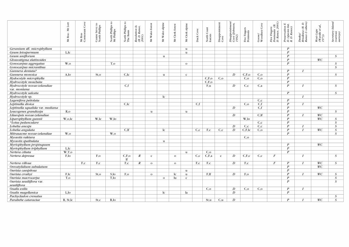
Mt Roa
- Mt Lo
rt
Mt Roa-
Corm
ora
nt C
ove
Cen
tre
biv
vy to
Nort
h P
hill
ips
Nort
h P
hill
ips
to
Mt Phill
ips
Nort
h P
hill
ips
to
The
Bas
in
Resolution Is.
(B. D. Rance,
2001)
Mt W
ales
fore
st
Mt W
ales
alp
ine
Mt C
lerk
fore
st
Mt C
lerk
alp
ine
Duck
Cove
Nort
h C
oas
t fo
rest
s
Dis
appoin
tmen
t C
ove
Disappointm
ent
Cove (Johnson,
1992)
Five
Fin
gers
Pen
insu
la
Goose
/ W
oodhen
Cove
Five Fingers
Peninsula (B.
D. Rance, 2001)
Preservation E.
D. (species list,
B. D. Rance)
Dusky/
Breaksea (B. D.
Rance & others)
West Cape
(Wardle et al.,
1973)
Secretary Island
(various
surveys)
Geranium aff. microphyllum u P Geum leiospermum L,lc u P Geum uniflorum u P S Glossostigma elatinoides P WC Gonocarpus aggregatus W,o T,o o P S Gonocarpus micranthus S Gunnera dentata? P I Gunnera monoica A,lo St,o C,lc u c D C,F,o C,o P S Hydocotyle microphylla C,F,o C,o C,o C,o P Hydrocotyle moschata C,F,o P Hydrocotyle novae-zelandiae var. montana
C,f F,u D C,c C,a P I S
Hydrocotyle salcata P S Hydrocotyle sp. lc I Lagenifera petiolata C,c P Leptinella dioica C,lc C,f C,o C,f P I Leptinella squalida var. mediana D C,f P WC Leucogenes grandiceps R,o u u P S Lilaeopsis novae-zelandiae D C,lf P I WC Liparophyllum gunnii W,o,lc W,lc W,lo W,lo P WC S *Lotus pedunculare C,c P S Lobelia anceps D C,c C,c P I S Lobelia angulata C,lf lc C,c F,c C,c D C,F,lc C,o P I WC S Mitrasacme novae-zelandiae W,o W,o P S Myosotis rakiura C,o Myosotis spathulata u Myriophyllum propinquum P WC Myriophyllum triphyllum L,lc P Nertera ciliata W,T,o u C,o P Nertera depressa F,lo F,o C,F,o
lf R c o C,c C,F,a c D C,F,c C,c F I S
Nertera villosa F,c F,c F,c R o o F,c F,c D F,c F P I WC S Oreostylidium subulatum P WC Ourisia caespitosa u P Ourisia crosbyi F,lc St,o S,lo F,o o lc u F,lf D F,o P I WC S Ourisia macrocarpa T,o T,lo o lu c P S Ourisia sessiliflora var. sessiliflora
P S
Oxalis exilis C,o D C,o C,o P I Oxalis magellanica L,lo lc la D P Pachycladon crenatus S Parahebe cataractae R, St,lc St,c R,lo St,u C,u D P I WC S

Mt Roa
- Mt Lo
rt
Mt Roa-
Corm
ora
nt C
ove
Cen
tre
biv
vy to
Nort
h P
hill
ips
Nort
h P
hill
ips
to
Mt Phill
ips
Nort
h P
hill
ips
to
The
Bas
in
Resolution Is.
(B. D. Rance,
2001)
Mt W
ales
fore
st
Mt W
ales
alp
ine
Mt C
lerk
fore
st
Mt C
lerk
alp
ine
Duck
Cove
Nort
h C
oas
t fo
rest
s
Dis
appoin
tmen
t C
ove
Disappointm
ent
Cove (Johnson,
1992)
Five
Fin
gers
Pen
insu
la
Goose
/ W
oodhen
Cove
Five Fingers
Peninsula (B.
D. Rance, 2001)
Preservation E.
D. (species list,
B. D. Rance)
Dusky/
Breaksea (B. D.
Rance & others)
West Cape
(Wardle et al.,
1973)
Secretary Island
(various
surveys)
Phyllachne colensoi Fe,o P S Plantago lanigera T,o Fe,lo u S *Plantago major P I Plantago triandra C,o C,c C,c P I S Plantago uniflora W,o W,lo c u c C,f P S Pseudognaphalium luteo-album C,o C,f D C,o P I S Psychrophylla novae-zelandiae W,o Fe,lo u P S Ranunculus acaulis C,o D P I Ranunculus glabrifolius P WC Ranunculus lyallii o P S Ranunculus membranifolius lo D P I S Ranunculus multiscapus P S *Ranunculus repens c P Ranunculus sp. L,lc u I Raoulia buchananii Fe,o,lc u S Raoulia grandiflora Fe,o Fe,c u u P S Raoulia subulata A,lo Raoulia youngii S Rumex flexuosus C,o P S Rumex neglectus C,u P WC S *Sagina procumbens C,u C,o C,u C,o P I S Samolus repens C,o,l,
c C,o D C,lo C,la P I
Schizeilema haastii var. cyanopetalum
R,lc √ u P
Schizeilema nitens P WC Scleranthus biflorus S Selliera radicans c,f P S Senecio biserratus? P I S Senecio glomeratus D P I Senecio lautus P S Senecio minimus P S Senecio wairauensis C,u C,o P I S *Sonchus aspera C,o P S Sonchus kirkii D P I S *Sonchus oleraceus C,u C,o D C,u P I S Stackhousia minima? u u *Stellaria media C,o P Stellaria parviflora F,o C,u D C,o P I WC S *Trifolium repens C,o C,o P I

Mt Roa
- Mt Lo
rt
Mt Roa-
Corm
ora
nt C
ove
Cen
tre
biv
vy to
Nort
h P
hill
ips
Nort
h P
hill
ips
to
Mt Phill
ips
Nort
h P
hill
ips
to
The
Bas
in
Resolution Is.
(B. D. Rance,
2001)
Mt W
ales
fore
st
Mt W
ales
alp
ine
Mt C
lerk
fore
st
Mt C
lerk
alp
ine
Duck
Cove
Nort
h C
oas
t fo
rest
s
Dis
appoin
tmen
t C
ove
Disappointm
ent
Cove (Johnson,
1992)
Five
Fin
gers
Pen
insu
la
Goose
/ W
oodhen
Cove
Five Fingers
Peninsula (B.
D. Rance, 2001)
Preservation E.
D. (species list,
B. D. Rance)
Dusky/
Breaksea (B. D.
Rance & others)
West Cape
(Wardle et al.,
1973)
Secretary Island
(various
surveys)
Viola cunninghamii P S Viola filicaulis F,o CF,o F,u F,lo P S MONOCOTS Grasses *Agrostis capillaris P I S Agrostis dyerii T,lc St,o W,o P S Agrostis meulleriana Fe,o Fe,o P S *Agrostis stolonifera C,o P *Anthoxanthus odoratum D C,lc P S Chionochloa acicularis T,S,W,
a F,lo W,f T,S,a W,lf o a o a W,F,
o W,a F P I WC S
Chionochloa conspicua St,o C,o C,u P WC Chionochloa crassiuscula var. torta
T,W,f T,c c o P WC S
Chionochloa ovata St,lo u P S Chionochloa pallens T,o,lc T,u o u o P S Chionochloa rigida var. amara u lc P S Austroderia richardii C,o F,lo C,c P WC S *Dactylis glomerata P S Deschampsia chapmanii u C,o C,o S Deyeuxia aucklandica T,o,lc T,o o u c C,o P WC S Dichelachne crinita C,u P Hierochloe novae-zelandiae T,o u P S Hierochloe recurvata T,o P S Hierochloa redolens P S *Holcus lanatus C,o D C,lc P I S Lachnogrostis pilosa u o F,u D P I S Lachnogrostis striata C,lc C,o C,o P S *Lolium perenne C,o P Microlaena avenacea F,c F,o u lc F,o F,f C,f D F,c F,C,f F P I WC S *Poa annua C,o P I S Poa astonii C,o C,c D C,lo P I WC S Poa breviglumis C,c C,o P WC Poa colensoi T,lc u o P S Poa hesperia/kirkii W,T,o T,o u P S Poa novae-zelandiae R,u,o P *Poa pratensis C,u P Rytidosperme gracile C,o C,o C,o C,o D C,o P I S Rytidosperme nigricans W,o u W,o P S Rytidosperme setifolia R,o T,o u D C,c P I WC S Trisetum tenellum? T,o P S

Mt Roa
- Mt Lo
rt
Mt Roa-
Corm
ora
nt C
ove
Cen
tre
biv
vy to
Nort
h P
hill
ips
Nort
h P
hill
ips
to
Mt Phill
ips
Nort
h P
hill
ips
to
The
Bas
in
Resolution Is.
(B. D. Rance,
2001)
Mt W
ales
fore
st
Mt W
ales
alp
ine
Mt C
lerk
fore
st
Mt C
lerk
alp
ine
Duck
Cove
Nort
h C
oas
t fo
rest
s
Dis
appoin
tmen
t C
ove
Disappointm
ent
Cove (Johnson,
1992)
Five
Fin
gers
Pen
insu
la
Goose
/ W
oodhen
Cove
Five Fingers
Peninsula (B.
D. Rance, 2001)
Preservation E.
D. (species list,
B. D. Rance)
Dusky/
Breaksea (B. D.
Rance & others)
West Cape
(Wardle et al.,
1973)
Secretary Island
(various
surveys)
*Vulpeia sp. P S Zotovia acicularis R,u P S Zotovia colensoi T ,o,lc u f P S Zotovia thomsonii W,c F,lo W,o W,C,T,
c o a o W,c W,c P WC S
Sedges Baumea tenax W,lf W,a F P I WC Carex appressa C,lc R C,c C,o C,c D C,o C,a P I S Carex acicularis R,o Fe,u S Carex berggrenii D P Carex comans C,o P S Carex coriacea P S Carex dissita L,o,lc F,lc C,l
c D F,o P I S
Carex flagellifera? C,o P I Carex gaudicaudiana P S Carex geminata C,o P I Carex inversa C,o Carex littorosa C,o C,o D C,o P Carex lucida S Carex pleiostachys C,o C,lc C,o D C,la P I WC S Carex pyrenoica var. cephalotes P S Carex secta W,o D P Carex solandri C,c C,o D C,o P I S Carex ternaria P I Carex trifida D P I Carex virgata P S Carpha alpina W,T,f F,lo W,c W,T,f W,c o f u f W,lf B,lf W,a F P I WC S Eleocharis acuta L,W,O,
lc L,c P I
Eleocharis gracilis W,lo W,lo I Eleocharis sphacelata L,c P I Ficinias nodosus W,lc P Ficinia spiralis D P Gahnia procera S,c F,o,lc F,f F,S,c F,c R o f u S,o C,o D S,W,a F P I WC S Isolepis aucklandica W,T,o,
lc W,o W,o o F,C,
o C,o F,u P WC S
Isolepis cernuua C,lc C,o W,o W,o D C,f C,c P I Isolepis habrus F,lc F,o F,o o P I WC S Isolepis inundata P S Isolepis preatextatus C,o CW,
u D C,lc C,c P I WC S
Lepidosperme australe W,lc W,lf W,c D W,c F P I WC S

Mt Roa
- Mt Lo
rt
Mt Roa-
Corm
ora
nt C
ove
Cen
tre
biv
vy to
Nort
h P
hill
ips
Nort
h P
hill
ips
to
Mt Phill
ips
Nort
h P
hill
ips
to
The
Bas
in
Resolution Is.
(B. D. Rance,
2001)
Mt W
ales
fore
st
Mt W
ales
alp
ine
Mt C
lerk
fore
st
Mt C
lerk
alp
ine
Duck
Cove
Nort
h C
oas
t fo
rest
s
Dis
appoin
tmen
t C
ove
Disappointm
ent
Cove (Johnson,
1992)
Five
Fin
gers
Pen
insu
la
Goose
/ W
oodhen
Cove
Five Fingers
Peninsula (B.
D. Rance, 2001)
Preservation E.
D. (species list,
B. D. Rance)
Dusky/
Breaksea (B. D.
Rance & others)
West Cape
(Wardle et al.,
1973)
Secretary Island
(various
surveys)
Oreobolus impar T,W,R, f
R,o T,f c u W,S,l,c
W,f P I WC S
Oreobolus pectinatus W,T,c W,o W,c,lf u o W,lo W,o P I S Oreobolus strictus W,c F,lo W,o W,c,lf W,c u W,lc W,u W,c F P I WC S Schoenus pauciflorus T,Wo T,W,c o u S,lc W,u C,c P I WC S Uncinia angustifolia P WC S Uncinia aucklandica CF,o D F,c P I Uncinia caespitosa U P S Uncinia drucei T,R,o R,o P S Uncinia egmontana? F P I S Uncinia filiformis F,o F,c F,o F,o F,c R c u o F,o F,c F,o D F,f F P I S Uncinia fuscovaginata T,o u u F,u P Uncinia gracilenta F,o o c o F,o D P I S Uncinia rubra C,f P Uncinia rupestris P S Uncinia uncinata F,o o u F,u C,o D F,o P I S Uncinia viridis T,c F,o T,c u F,o P WC S Uncinia sp. S,o F,c F,o F,o F,o u u I WC S Orchids Adenochilus gracilis F,u P Aporostylis bifolia F,S,c F,o F,c T,c F,Wo o u o F,c W,u S,lf F P I WC S Corybas cheesemanii P I Drymoanthus adversus D P I WC Earina autumnalis F,o F,c R lc F,o F,f C,f D F,c F,o F P I WC S Earina mucronata F,o F,o R √ lc F,o F,o D P I WC S Ichthyostonum pygmaeum F,u F P I WC S Microtis unifolia S Nematocerus acuminatus F,o F,o R D F,lo F P I S Nematocerus macranthus F,u P Nematocerus trilobus R u D F,lc P I Petalochilis spp. D P S Prasophyllum colensoi T,o R,o Fe,o W,o u u W,o F P I WC S Pterostylis australis D P S Pterostylis banksii? P I Pterostylis graminea F,o P WC Pterostylis montana? F,o F,o S Singularybas oblongus F,c F,o F,o R D F P I WC S

Mt Roa
- Mt Lo
rt
Mt Roa-
Corm
ora
nt C
ove
Cen
tre
biv
vy to
Nort
h P
hill
ips
Nort
h P
hill
ips
to
Mt Phill
ips
Nort
h P
hill
ips
to
The
Bas
in
Resolution Is.
(B. D. Rance,
2001)
Mt W
ales
fore
st
Mt W
ales
alp
ine
Mt C
lerk
fore
st
Mt C
lerk
alp
ine
Duck
Cove
Nort
h C
oas
t fo
rest
s
Dis
appoin
tmen
t C
ove
Disappointm
ent
Cove (Johnson,
1992)
Five
Fin
gers
Pen
insu
la
Goose
/ W
oodhen
Cove
Five Fingers
Peninsula (B.
D. Rance, 2001)
Preservation E.
D. (species list,
B. D. Rance)
Dusky/
Breaksea (B. D.
Rance & others)
West Cape
(Wardle et al.,
1973)
Secretary Island
(various
surveys)
Thelymitra cyanea W,T,R, c
F,lo W,c T,c W,o o c S,lc S,u W,a P WC S
Thelymitra longifolia T,o o D F P I WC S Thelymitra pachyphylla S Townsonia deflexa S,o I Waireia stenopetala T,W,o T,o u u u P WC S Winika cunninghamii F,c F,c R u F,o F,o D F,c F P I WC S Rushes Apodasmia similis C,o C,la P I S Centrolepis ciliata W,c W,o W,o,lc W,o o o o W,lo W,f F P I WC S Centrolepis minima S Centrolepis pallida W,o P S Empodisma minus W,lc T,lo W,lf u W,f F P I WC Gaimardia setacea W,c W,c W,o,lc u o W,lc W,o P I WC S Juncus antarcticus W,o,lc W,lc u c c P S *Juncus articulatus W,L,o P *Juncus bufonius C,u C,o P S *Juncus bulbosus L,c P Juncus edgariae C,c P I Juncus novae-zelandiae C,lc W,o S,u C,c P Juncus pauciflorus? C,o C,o P Juncus planifolius C,F,o C,u D C,o P I Apodasmia similis C,o C,la P I S Luzula banksiana var. acra D P I Luzula congesta F,u Luzula crinita var. petrieana T,o,lc Fe,lc u c P S Luzula picta var. limosa P S Luzula pumila Fe,lo P S Luzula rufa P S Rostokovia magellanica W,lc Triglochin striatum C,lf C,o D C,lf P Other monocots Astelia fragrans F,o,lf F,o F,o F,o F,o R c F,o F,o C,c D F,o F,c F P I S Astelia linearis T,W,f F,lc S,F,lc T,f W,o f c o f P I WC S Astelia nervosa F,S,o F,c F,c F,o f o o F,f P WC S Astelia nivicola var. moriceae P S Astelia petrieii S,B,o S,u o P S Astelia subulata? W,o,lc S Bulbinella gibbsii var. balanifera T,o T,c u c P WC S

Mt Roa
- Mt Lo
rt
Mt Roa-
Corm
ora
nt C
ove
Cen
tre
biv
vy to
Nort
h P
hill
ips
Nort
h P
hill
ips
to
Mt Phill
ips
Nort
h P
hill
ips
to
The
Bas
in
Resolution Is.
(B. D. Rance,
2001)
Mt W
ales
fore
st
Mt W
ales
alp
ine
Mt C
lerk
fore
st
Mt C
lerk
alp
ine
Duck
Cove
Nort
h C
oas
t fo
rest
s
Dis
appoin
tmen
t C
ove
Disappointm
ent
Cove (Johnson,
1992)
Five
Fin
gers
Pen
insu
la
Goose
/ W
oodhen
Cove
Five Fingers
Peninsula (B.
D. Rance, 2001)
Preservation E.
D. (species list,
B. D. Rance)
Dusky/
Breaksea (B. D.
Rance & others)
West Cape
(Wardle et al.,
1973)
Secretary Island
(various
surveys)
Cordyline indivisa P I S Freycinetia baueriana o,lc o,lc D F,lo F,o P I Libertia micrantha F,o F,o F,o,lc R u F,o F,lc P I WC S Luzuriaga parviflora F,o F,o F,o F,o,lc R o lc F,o F,o D F,lc F P I WC S Phormium cookianum S,T,o F,o S,o S,T,o F,o R c o c C,o F,C,S
,o C,o D C,F,S,
o C,c F P I WC S
Potamogeton cheesemanii St,lc St,lc c F,lu P S Potamogeton suboblongus St,o D P WC Rhipogonum scandens F,o F,o R F,o F,o D F,lo F P I WC S